


Highlights
What are the main findings?
- DCA-Net explicitly addresses boundary confusion in long-tail categories of MLS point clouds by jointly modeling local geometric context, channel-wise semantic responses, and class-boundary sampling.
- The proposed method improves the segmentation of minority categories, slender objects, and boundary regions, achieving mIoU scores of 96.6%, 84.1%, and 69.4% on the MLS, Toronto3D, and S3DIS datasets, respectively.
What are the implications of the main findings?
- The proposed design enhances intra-neighborhood point-to-point context modeling and strengthens local feature representation, enabling more discriminative LiDAR point cloud segmentation.
- The framework enables more accurate semantic interpretation of MLS-acquired urban road-scene point clouds, providing reliable perception information for road scene modeling and autonomous driving applications.
Abstract
Mobile LiDAR systems (MLS) enable rapid acquisition of large-scale 3D point cloud data. Semantic segmentation of the acquired point clouds is an important task in outdoor scene understanding and environmental perception for autonomous driving. However, existing methods tend to suffer from boundary confusion when segmenting MLS point clouds with long-tail categories. To address this problem, we propose the Dilated Context Attention Network (DCA-Net), which consists of a dilated local geometric encoding module, a channel attention pooling module, and a category-boundary sampling strategy. The dilated local geometric encoding module expands point-to-point connections within a fixed neighborhood to strengthen contextual modeling among neighboring points. The channel attention pooling module uses a channel attention mechanism to enhance informative channel responses in neighborhood features, thereby improving local feature representation. The category-boundary sampling strategy increases the sampling probabilities of minority-category points and boundary points, reducing feature information loss during down-sampling. Experimental results on the S3DIS, Toronto3D, and MLS road scene datasets show that DCA-Net achieves mIoU scores of 69.4%, 84.1%, and 96.6%, respectively. These results demonstrate that the proposed method alleviates boundary confusion in point cloud segmentation with long-tail categories, without causing a noticeable degradation in the segmentation performance of majority categories.
1. Introduction
Mobile LiDAR systems (MLS) can rapidly acquire large-scale 3D LiDAR point cloud data in outdoor scenes [1,2,3]. Semantic segmentation of MLS point clouds has important application value in road scene modeling, autonomous driving perception, and urban digital twins [4].
With the rapid development of deep learning, PointNet [5] first learns directly from unstructured 3D point clouds and lays the foundation for end-to-end point cloud feature learning. Subsequent models [6,7] further introduce local feature aggregation and hierarchical sampling strategies, enabling networks to learn more discriminative geometric features within local spatial regions. These methods based on fixed neighborhoods mainly rely on predefined local regions for feature aggregation, which makes it difficult to fully model contextual relationships among points outside the neighborhood. To enhance the representation of long-range dependencies in point clouds, Transformer architectures are introduced into point cloud semantic segmentation. Point Transformer [8] designs a vector attention mechanism based on spatial relationships in point clouds, allowing the model to capture contextual information while better preserving local geometric structures. Subsequent Point Transformer variants [9,10,11] further strengthen long-range dependencies among points and capture semantic context over larger spatial ranges, showing strong global modeling ability in complex scene understanding. However, Transformer-based models provide relatively limited explicit modeling of local geometric details and usually require large amounts of data to learn local spatial relationships. Existing semantic segmentation networks still tend to suffer from boundary confusion when processing MLS point clouds with long-tail categories. This problem is mainly reflected in three aspects: (1) Existing local neighborhood feature learning methods mostly rely on continuous nearest-neighbor point sets for aggregation, which causes contextual relationships among points to be insufficiently modeled during local aggregation. This limitation is especially evident for easily confused categories with similar geometric forms or strong contextual dependencies. (2) Existing local feature aggregation methods mainly focus on the feature importance of different points within a neighborhood, while paying insufficient attention to differences in semantic contribution across feature channels. As a result, redundant feature channels often weaken effective feature representations during aggregation, making relevant features difficult to sufficiently enhance and ultimately reducing segmentation accuracy. (3) The long-tail category distribution in large-scale MLS point clouds makes long-tail categories easy to be overwhelmed by majority categories during hierarchical feature learning. Existing sampling strategies, such as random sampling [12] and FPS [6], tend to retain majority-category points preferentially, causing the features of some long-tail category points to be weakened during sampling.
To address these practical challenges, this paper proposes the Dilated Context Attention Network (DCA-Net), which aims to improve semantic segmentation of MLS point clouds and alleviate boundary confusion in point cloud segmentation with long-tail categories. The main contributions are as follows.
- (1)
- We propose a dilated local geometric encoding module (DLGE). This module expands point-to-point connections within a fixed neighborhood and establishes richer contextual relationships among neighboring points, enabling the network to obtain more sufficient local structural information.
- (2)
- We propose a channel attention pooling module (CAP). By using a channel attention mechanism, CAP enhances informative channel responses in neighborhood features, strengthens semantically relevant feature representations, and suppresses interference from redundant channels.
- (3)
- We introduce a category-boundary sampling strategy (CBS). By increasing the sampling probabilities of long-tail category points and boundary points, CBS reduces feature information loss during sampling and improves semantic segmentation performance on MLS point clouds.
2. Related Work
2.1. Point Cloud Semantic Segmentation
With the development of deep learning, point cloud semantic segmentation methods gradually shift from hand-crafted feature design to end-to-end point cloud feature learning frameworks. PointNet-family methods [5,6,7] first introduce multilayer perceptrons into unordered point set modeling, and learn point cloud features through shared MLPs and hierarchical sampling and aggregation strategies while progressively enlarging the network receptive field. Point convolution methods [13,14,15,16,17] further incorporate convolution into unstructured point cloud processing, and learn neighborhood geometric structures through local graphs, continuous convolution kernels, or kernel point convolution. Methods such as PVCNN [18], KPConv [19] and SqueezeSegV3 [20] improve point cloud convolution from the perspectives of joint point-voxel modeling and adaptive convolution, further demonstrating the efficiency of convolution-based point cloud processing. Efficient point cloud segmentation methods represented by RandLA-Net [12] and its variants [21,22] adopt random sampling and multilayer local context aggregation to reduce the complexity of point cloud processing while enhancing local feature representation. Subsequent methods that follow the idea of local context aggregation [23,24,25] mainly enhance local geometric representation through neighborhood feature learning and multi-scale feature aggregation, and improve the adaptability of models to scale variations and uneven density distributions. However, these methods still make insufficient use of contextual relationships among points within local neighborhoods. Inspired by the performance of the Transformer framework [26] in NLP, related ideas are introduced into point cloud semantic segmentation and lead to Point Transformer (PTv1) [8]. PTv2 [11] further strengthens the original attention structure by introducing grouped vector attention. Around the Transformer architecture, Stratified Transformer [27], Fast Point Transformer [28], and OctFormer [29] also propose more efficient solutions for point cloud semantic segmentation. However, Transformer-based methods still suffer from high computational cost, since the complexity of self-attention increases significantly with the number of points, making them difficult to apply efficiently to large-scale MLS point cloud data. In addition, LPFP and PCLN [30] construct unified stacking and distillation frameworks to enhance the feature representation ability of point cloud segmentation networks. Beyond the standard supervised training paradigm, existing studies also attempt to improve model performance in weakly supervised [31,32,33] and few-shot point cloud [34,35] semantic segmentation settings.
2.2. Local Context Modeling
Local contextual modeling aims to extract discriminative semantic relationships from the neighborhood structures of irregular point sets. Existing studies [36,37,38] improve local structural representation by explicitly encoding spatial differences between points or enhancing feature interactions within neighborhoods. These methods compensate, to some extent, for the limited perception of local structural information in point-wise independent feature learning, enabling the network not only to focus on the features of individual points but also to use relative positions and feature differences among neighboring points for semantic discrimination. Most local relation modeling methods still take the center point as the core and aggregate neighborhood features into the center-point representation. Contextual interactions among non-center points within the neighborhood are often insufficiently explored, which limits the representation of local structural relationships. To obtain richer contextual information, another line of methods [39,40,41] attempts to enhance point cloud feature representation by introducing multi-scale neighborhoods or combining local and non-local relationships. These studies use sparse neighborhoods or joint local-global modeling mechanisms, allowing the network to capture point-wise dependencies over a larger spatial range and improving its adaptability to sparse distributions and complex local structures. To address point mixing in boundary regions, some studies [42,43] distinguish different semantic components within local regions from the perspectives of neighborhood semantic differences or boundary interaction relationships, thereby alleviating mutual interference between adjacent categories during feature aggregation. Existing methods mainly focus on the relative relationship between the center point and each individual neighboring point when encoding features within a fixed neighborhood, while the contextual connections among neighboring points remain insufficiently used. Therefore, this paper introduces a dilated local geometric encoding module, which expands contextual relationships among points within a fixed neighborhood through dilated convolution without changing the neighborhood search range.
Unlike existing point-cloud dilated convolution and multi-scale context modeling methods, DLGE does not enlarge the receptive field by increasing the neighborhood search radius or by constructing additional multi-scale neighborhoods. Instead, DLGE keeps the KNN neighborhood size unchanged and introduces dilated convolution along the neighborhood feature dimension. This design establishes sparse connections between non-adjacent neighboring points within the same local region, thereby enhancing point-to-point contextual modeling inside the neighborhood while preserving the original local support range.
2.3. Feature Aggregation with Attention
In point cloud semantic segmentation, attention mechanisms are commonly used to adaptively weight neighboring points or feature channels, thereby enhancing key feature responses and suppressing redundant features. Feature aggregation in early networks usually relies on max pooling, average pooling, or simple weighted fusion [5,6,13,19,36]. Simple pooling operations can capture the overall features of local regions, but they tend to ignore the differences in the contributions of different neighboring points to the semantic discrimination of the center point. Point Attention Network [44] introduces attention mechanisms into local neighborhood aggregation at an early stage and enhances interactions among point features within the neighborhood through point attention. Subsequent methods [42,45] introduce attention weights into local graph structures or nodes to measure the contribution of different neighboring points to the feature update of the center point. Refs. [46,47,48] start from contextual dependencies over larger spatial ranges and use spatial attention or dual attention mechanisms to enhance scene-level semantic understanding. Channel attention focuses on response differences across feature dimensions and strengthens semantically relevant channels by adaptively recalibrating channel-wise weights. SE-Net first improves convolutional feature representation by explicitly modeling inter-channel dependencies. Subsequently, methods such as [49,50,51] further improve attention modeling from the perspective of joint channel-spatial interaction, enabling networks to highlight key features and suppress redundant responses. These studies indicate that semantic responses along the channel dimension are not equally important, and channel-level feature enhancement can effectively improve the discriminability of feature representations. Although existing attention mechanisms achieve promising performance in point cloud semantic segmentation, most methods still make insufficient use of channel-level differences in local point features. In this paper, we introduce a channel-aware attention pooling module into the local feature aggregation process. This module enhances informative feature-channel responses in neighborhood features, thereby strengthening target-related features and improving local feature representation.
3. Methods
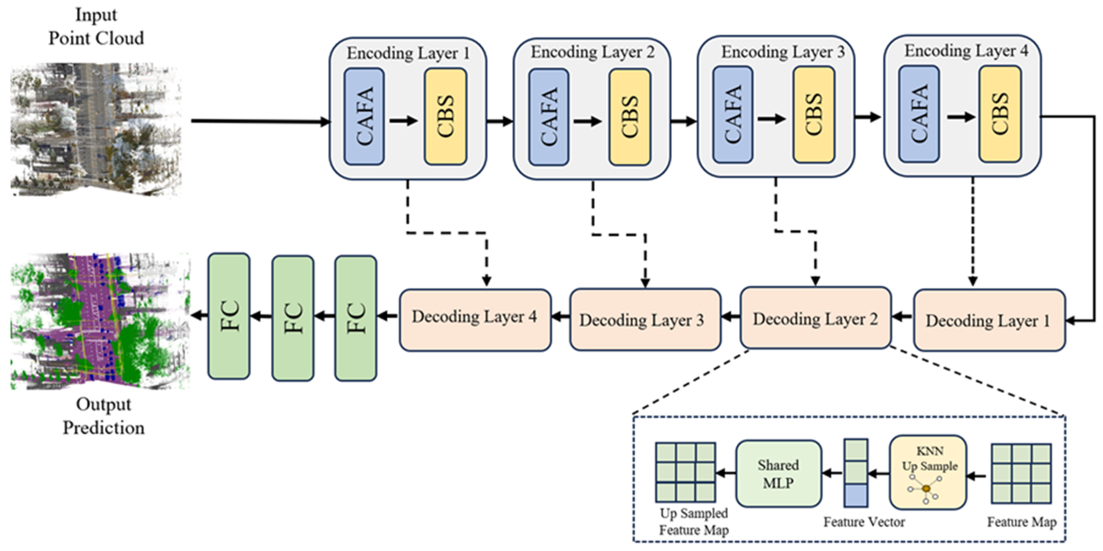
The proposed DCA-Net aims to address boundary confusion in MLS point cloud semantic segmentation with long-tail categories by expanding intra-neighborhood contextual relationships and enhancing channel-wise feature responses. As shown in Figure 1, DCA-Net adopts an encoder–decoder architecture, where the encoder consists of four hierarchical encoding layers. Each encoding layer contains Channel Attention Feature Aggregation and Class-Boundary Sampling, and skip connections are used to transfer encoded features at different levels to the corresponding decoding stages. The network takes the point cloud to be segmented as input. The input point features first enter the hierarchical encoding stage, where multiple layers of local feature learning and down-sampling progressively enlarge the receptive field and increase the feature dimension. The decoding stage gradually restores the resolution of point features and combines shallow features from the encoding stage to generate the final semantic segmentation results.
Figure 1.
The detailed architecture of the proposed DCA-Net.
3.1. Network Architecture
The encoder consists of four consecutive encoding layers. Each encoding layer mainly includes a channel-aware feature aggregation module and a category-boundary sampling strategy. The channel-aware feature aggregation module encodes geometric structures and semantic features within local neighborhoods, and improves local feature representation by enhancing informative channel responses. The category-boundary sampling strategy reduces the point cloud scale while increasing the retention probabilities of long-tail category points and boundary points during sampling, thereby alleviating the loss of key feature information caused by down-sampling in large-scale point clouds. The decoder also consists of four decoding layers, which gradually restore low-resolution semantic features to the original point cloud scale. As shown in Figure 1, each decoding layer adopts KNN-based up-sampling to propagate low-resolution point features to the point set of the previous layer, and uses shared MLPs to map the up-sampled features. To fully exploit structural details and semantic information at different levels, features from the corresponding encoder layers are transferred to the decoding stage through skip connections and fused with the up-sampled features.
To improve the readability and reproducibility of the proposed architecture, Table 1 summarizes the main configuration of each encoder layer. Before entering the encoder, the raw point features are first mapped to an 8-dimensional feature representation. Each encoder layer then applies dilated local geometry encoding, channel-aware attention pooling, residual feature aggregation, and class-boundary sampling. The neighborhood size is kept fixed during local feature aggregation, while the feature dimension is progressively increased along the hierarchical encoder.
Table 1.
Summary of encoder layer configurations in DCA-Net.
As shown in Table 1, the encoder progressively increases the feature dimension from 8 to 512 while reducing the point resolution through hierarchical sampling. This design enables DCA-Net to learn increasingly abstract semantic features while preserving local geometric context through fixed-size neighborhood aggregation.
After multi-level decoding, the network uses several fully connected layers to classify the restored point features. It outputs prediction scores for each point over all semantic categories and generates the final semantic label according to the category with the maximum response. DCA-Net extracts contextual semantic features through hierarchical encoding and introduces category-boundary sampling to preserve key point information.
3.2. Channel Attention Feature Aggregation (CAFA)
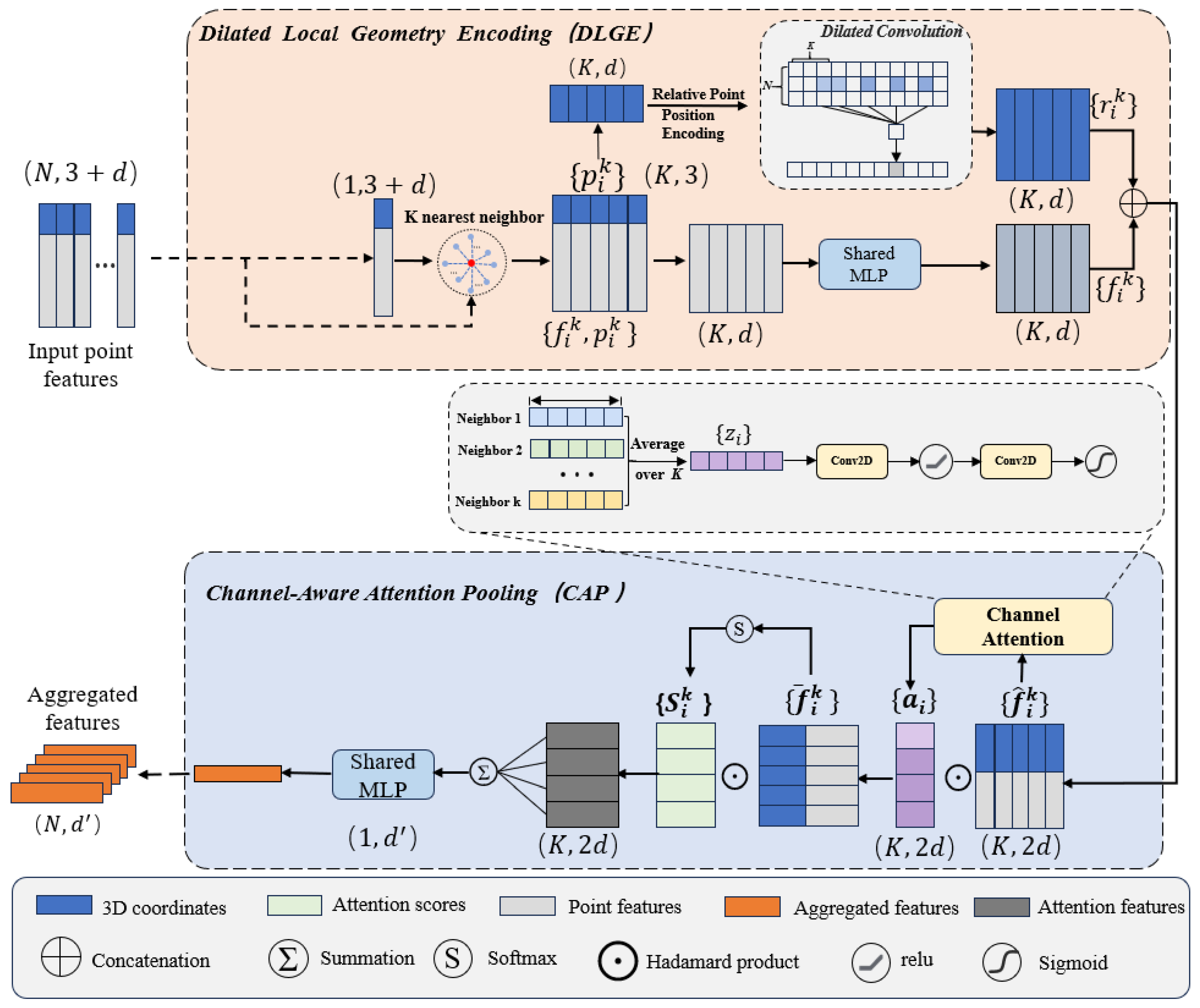
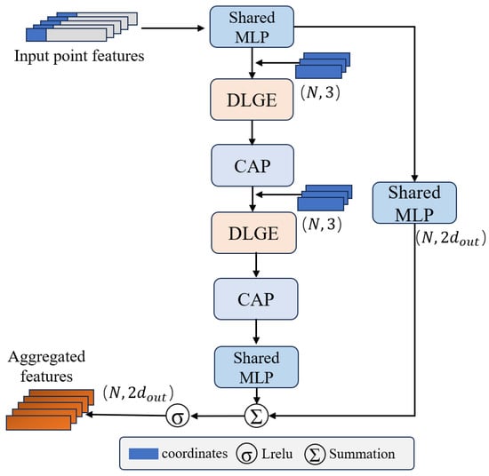
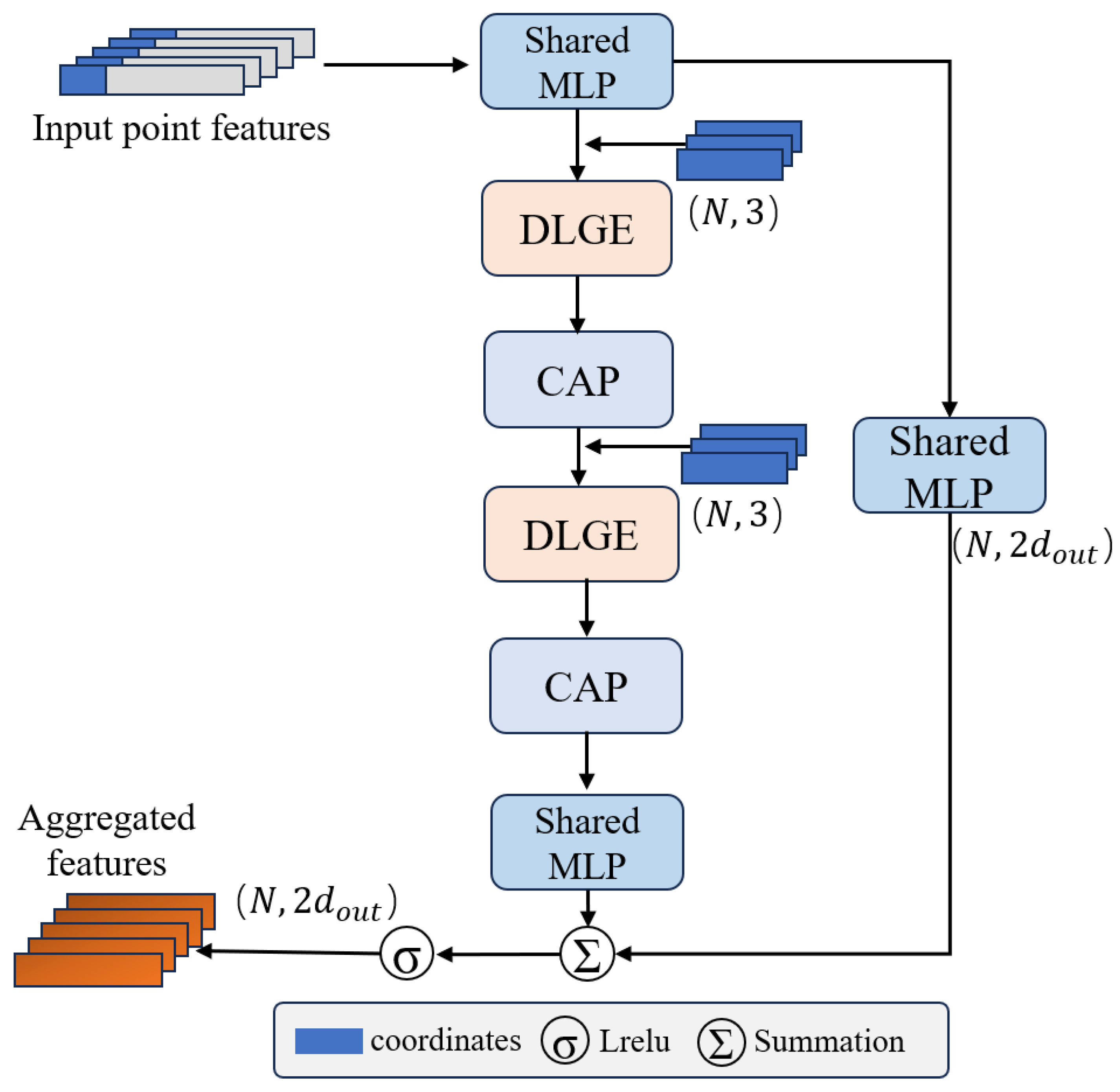
The proposed Channel Attention Feature Aggregation (CAFA) module is applied in parallel to each 3D point. As shown in Figure 2, it consists of two neural units: (1) Dilated Local Feature Aggregation and (2) Channel-Aware Attention Pooling.
Figure 2.
Channel-Aware Feature Aggregation Module.
3.2.1. Dilated Local Feature Aggregation
Neighborhood aggregation-based point cloud segmentation methods mainly extract point cloud features through local neighborhood construction and neighborhood feature encoding. However, their modeling of intra-neighborhood contextual relationships remains insufficient, which easily leads to boundary confusion or object discontinuity in point clouds with long-tail categories. To address this issue, this paper proposes the Dilated Local Geometry Encoding (DLGE) module. By introducing a dilated convolution mechanism into neighborhood feature encoding, DLGE effectively captures larger-scale point-to-point contextual information while keeping the neighborhood size unchanged. The module mainly contains the following steps.
Relative Position Encoding. Given a center point and its neighboring point set obtained by KNN, we first construct relative position encoding to characterize local geometric relationships. Specifically, for each neighboring point, the following feature representation is constructed:
where denotes the Euclidean distance and denotes the feature concatenation operation. This design integrates relative geometric information and absolute positional information. It preserves global spatial references while characterizing local structural relationships, thereby providing sufficient representational capacity for subsequent geometric modeling.
Dilated Local Feature Aggregation. After obtaining the neighborhood features, we introduce dilated convolution along the neighborhood dimension to enhance contextual relationship modeling. The neighborhood features are represented as a tensor , where denotes the batch size, denotes the number of feature channels, denotes the number of points, and denotes the neighborhood size of each point. A one-dimensional dilated convolution is then applied along the neighborhood index dimension, namely the dimension:
where denotes the dilation rate. By sampling neighboring points at intervals in the neighborhood index space, local feature aggregation can introduce point-to-point connections over a larger range, thereby extending contextual information among points. As shown in Figure 2, the proposed DLGE module adopts a dual-branch structure to jointly model neighborhood information and achieve effective fusion of spatial geometric structures and semantic features. One branch applies dilated convolution to the relative position encoding , enhancing the representation of local contextual relationships by introducing dilation along the neighborhood dimension. The other branch applies a shared multilayer perceptron (MLP) to the neighboring point features for semantic encoding, extracting stable and discriminative feature representations. After the two branches complete their respective feature transformations, their outputs are integrated through feature fusion and further mapped by a shared MLP to obtain the final local aggregated feature representation:
This dual-branch fusion strategy decouples geometric information and semantic features during modeling. Structural relationships are strengthened through dilated neighborhood modeling, while semantic representations maintain their stability.
3.2.2. Channel-Aware Attention Pooling
Unlike traditional hard aggregation operations such as max pooling or mean pooling, CAP performs a more fine-grained selection of fused neighborhood features through channel-level feature enhancement and neighborhood attention pooling. First, CAP models the importance of different feature channels along the channel dimension. For the fused neighborhood feature , average pooling is performed along the neighborhood dimension to obtain the channel descriptor corresponding to the center point :
where . By statistically aggregating the neighborhood representations, this descriptor characterizes the overall response intensity of the current local region on each channel. Then, a bottleneck structure composed of two convolutions is used to model inter-channel dependencies:
where and denote learnable convolution parameters, denotes the ReLU activation function, and denotes the Sigmoid activation function. The resulting serves as the channel attention weight, which is used to recalibrate the fused neighborhood features along the channel dimension:
After this step, channel responses with strong discriminative ability are adaptively enhanced, while redundant or interfering channel information is suppressed. The recalibrated neighborhood feature set is denoted as:
After channel recalibration, CAP further performs attention pooling along the neighborhood dimension to characterize the contribution differences in different neighboring points to the center-point representation. A shared function is used to generate attention responses, followed by Softmax normalization along the neighborhood dimension:
where is implemented by a convolution. In our implementation, the output dimension of is kept the same as the input feature channel dimension. Therefore, represents channel-related neighborhood attention weights. CAP then performs a weighted summation over the recalibrated neighborhood features according to the learned attention weights:
where denotes the channel-related attention weight corresponding to the neighboring point, and denotes the local feature after attention aggregation. Finally, a shared MLP is used to map the aggregated feature, producing the output feature of CAP:
3.2.3. Context-Expanded Residual Block
During large-scale point cloud encoding, repeated down-sampling may weaken or discard slender objects, boundary points, and minority-category points. To enhance the local contextual representation after down-sampling, this paper designs a Context-Expanded Residual Block, whose structure is shown in Figure 3. This module consists of two cascaded local feature aggregation units. Each unit includes dilated local geometry encoding and channel attention pooling, and residual connections are used to preserve shallow feature information. The input point features are first mapped by a shared MLP and then fed into the first local feature aggregation unit. This unit establishes richer point-to-point connections within the neighborhood through dilated local geometry encoding and enhances informative feature responses through channel attention pooling. In the second aggregation stage, the network further propagates the local features obtained from the previous stage, enabling the center point to indirectly perceive point-to-point relationships over a larger spatial range. Through this progressive aggregation scheme, the model can expand point-wise contextual information without directly increasing the neighborhood search size, thereby enhancing local structural continuity and semantic discrimination in boundary regions. Meanwhile, the residual branch maps shallow features to the same dimension as the main branch and adds them to the main-branch output point by point. The aggregated features are then obtained through an activation function. This design alleviates information attenuation caused by multi-level feature aggregation, enabling the network to obtain more sufficient contextual representation while preserving detailed features.
Figure 3.
Architecture of the Context-Expanded Residual Block.
3.3. Class-Boundary Sampling (CBS)
In large-scale point cloud semantic understanding, the sampling strategy has a fundamental influence on model performance. Therefore, this paper proposes a Class-Boundary Sampling (CBS) strategy, which jointly models center-point selection, local block reconstruction, and hierarchical down-sampling.
To increase the participation of long-tail category samples, we introduce a category distribution constraint in the center-point selection stage. Let the frequency of category in the training set be
where denotes the number of points in category . Based on this statistic, we construct the category sampling weight as
where is a regulating coefficient and is a numerical stability term. This weight assigns higher sampling priority to long-tail categories. For any point , whether it is selected as a center point is jointly determined by its current sampling state and the category weight:
where denotes the category label of the point. By selecting center points through minimizing , the sampling probability of long-tail categories is increased while spatial coverage is maintained. Meanwhile, to avoid distribution shift caused by excessive repeated sampling of extremely rare categories, we introduce a dynamic suppression strategy based on historical statistics. By recording the number of times each category is selected as the center point, categories that have been oversampled are adaptively masked, thereby achieving a stable balance between overall category balance and sampling diversity. After the center point is determined, a local point cloud block is constructed through nearest-neighbor search. Since the category distribution within a local region may still be highly imbalanced, this paper further adopts a category-adaptive resampling strategy to improve the stability of local feature learning.
Let denote the number of points of category in a local block. Its target sampling number is defined as
where is the threshold for extremely rare categories, and denotes the average target number of points computed according to the current number of categories. This strategy preserves the original distribution of extremely rare categories to avoid the risk of overfitting. For medium-frequency categories, it performs moderate enhancement to alleviate category imbalance during sampling. When the number of points after resampling exceeds the predefined upper bound, we design a category-frequency-based pruning mechanism. For each point , its removal probability is defined as
which means that majority-category points are preferentially removed, while minority categories are protected. Through the joint strategy of resampling and dynamic pruning within local blocks, the local blocks adaptively adjust their category distribution while satisfying the constraint on the total number of points.
In addition to category information, the geometric structure of point clouds is also an important factor affecting sampling quality. To enhance the model perception of local structural variations, we introduce a geometry-aware down-sampling strategy at the initial encoding stage. For each point , based on its neighboring point set , the geometric variation metric is defined as
This metric reflects the spatial variation intensity of a local region. Based on this metric, we construct the sampling probability distribution as
where [0, 1] is a trade-off parameter. This strategy assigns higher sampling probabilities to regions with strong geometric variations, such as boundaries or structural transition regions, thereby effectively preserving key local structural information. In subsequent layers, to control computational complexity and avoid excessive bias, we adopt random down-sampling, allowing the model to gradually shift from structure-sensitive sampling to global modeling.
To dynamically adjust the sampling process, we maintain a state variable that is updated during training. For a selected local block, the update amount of its corresponding points is defined as
where denotes the distance from the point to the center point, is the normalization term, and is the category update weight. This design makes the state values of points belonging to majority categories grow faster, thereby reducing their probability of being sampled again. In contrast, long-tail category points are retained for a longer period, which increases their probability of being sampled multiple times. Meanwhile, we set a lower bound for the update weight to ensure that visited regions can quickly reduce their priority, thereby improving the spatial coverage efficiency of the overall sampling process and avoiding repeated sampling of local regions.
4. Experiments and Analysis
4.1. Datasets
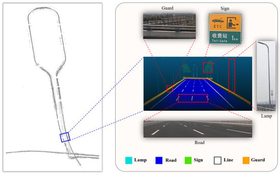
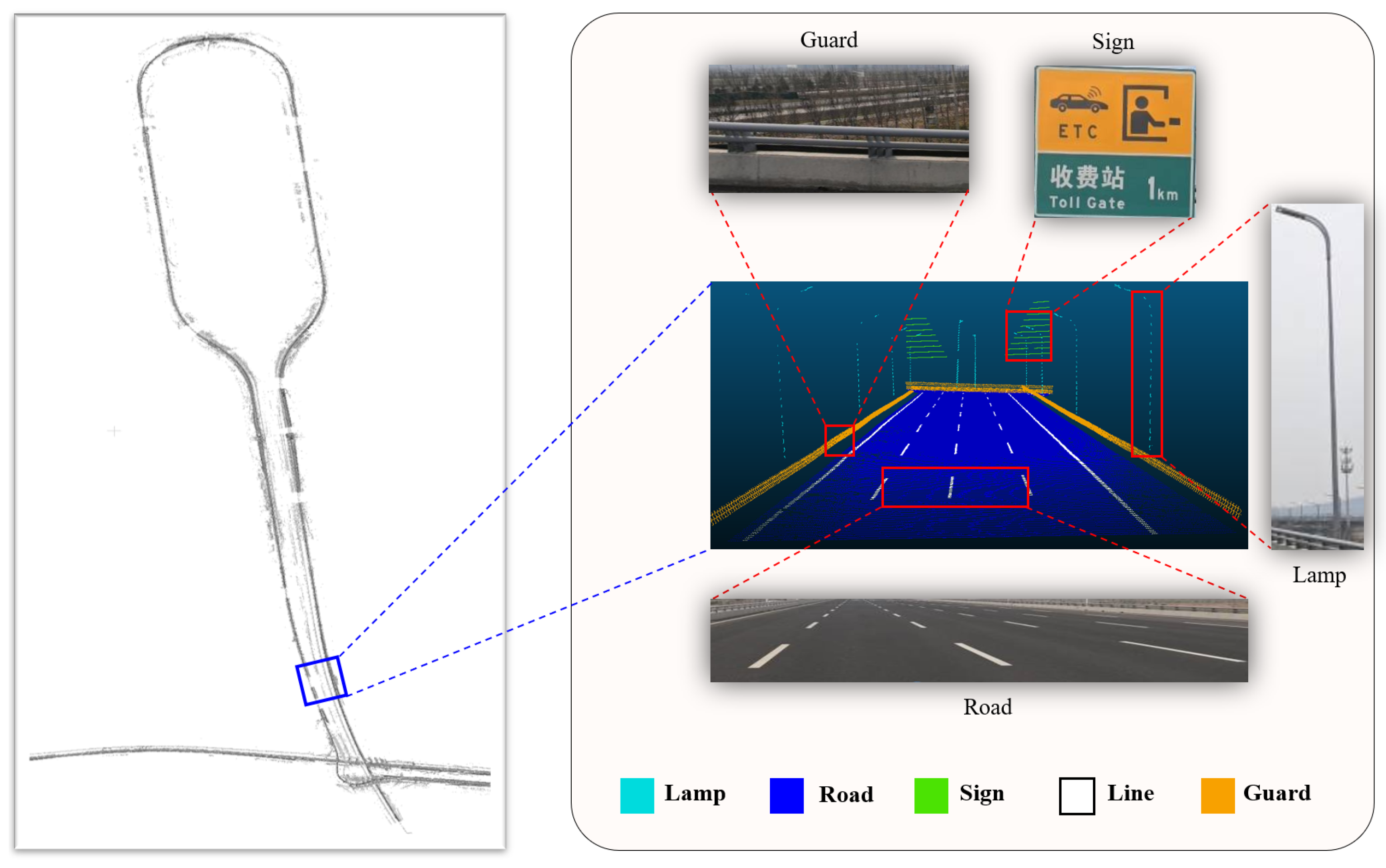
The MLS road scene dataset uses mobile laser scanning point clouds collected from approximately 180 km of roads around a large city in China as the data source, covering various typical road scenes. This dataset contains five types of objects: road, lane line, guardrail, lamp, and sign. As shown in Figure 4, different semantic categories are visualized with different colors. To comprehensively evaluate the effectiveness of the proposed method, this paper also selects two publicly available datasets, Toronto-3D [1] and S3DIS [52], for comparative experiments.
Figure 4.
Point cloud datasets by a mobile LiDAR system.
4.2. Experimental Setups
To quantify model performance and comprehensively evaluate the experimental results of DCA-Net on the three datasets, we use class-wise intersection over union (IoU), mean intersection over union (mIoU), and overall accuracy (OA) as the evaluation metrics, which are defined as follows:
where TP denotes the number of true positive samples, FP denotes the number of false positive samples, FN denotes the number of false negative samples, i denotes the i-th semantic category, n denotes the total number of semantic categories, and N denotes the total number of points.
All experiments are conducted on an NVIDIA RTX4090 GPU with 24 GB memory. The deep learning network model is implemented in Python 3.8, mainly using PyTorch 1.21.1, CUDA 12.8, and CuDNN 7.5. During training, the initial learning rate is set to 0.001, the batch size is set to 8, and the learning rate decay rate is set to 0.7.
4.3. Comparison Experiments
To comprehensively evaluate the semantic segmentation performance of DCA-Net, this paper conducts comparative experiments with various representative point cloud semantic segmentation methods on the MLS road scene dataset, the Toronto3D outdoor point cloud dataset, and the S3DIS indoor scene dataset. The MLS dataset is used to verify the segmentation performance of the proposed method on long-tail categories and boundary regions in road scenes, such as lane lines and guardrails. The Toronto3D dataset further evaluates the segmentation accuracy of the model in large-scale outdoor point cloud scenes. The results on the S3DIS dataset verify the generalization ability of the proposed method in complex indoor scenes.
4.3.1. Comparison Experiments on MLS
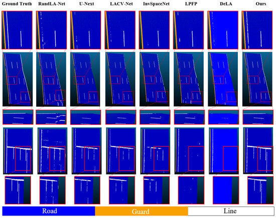
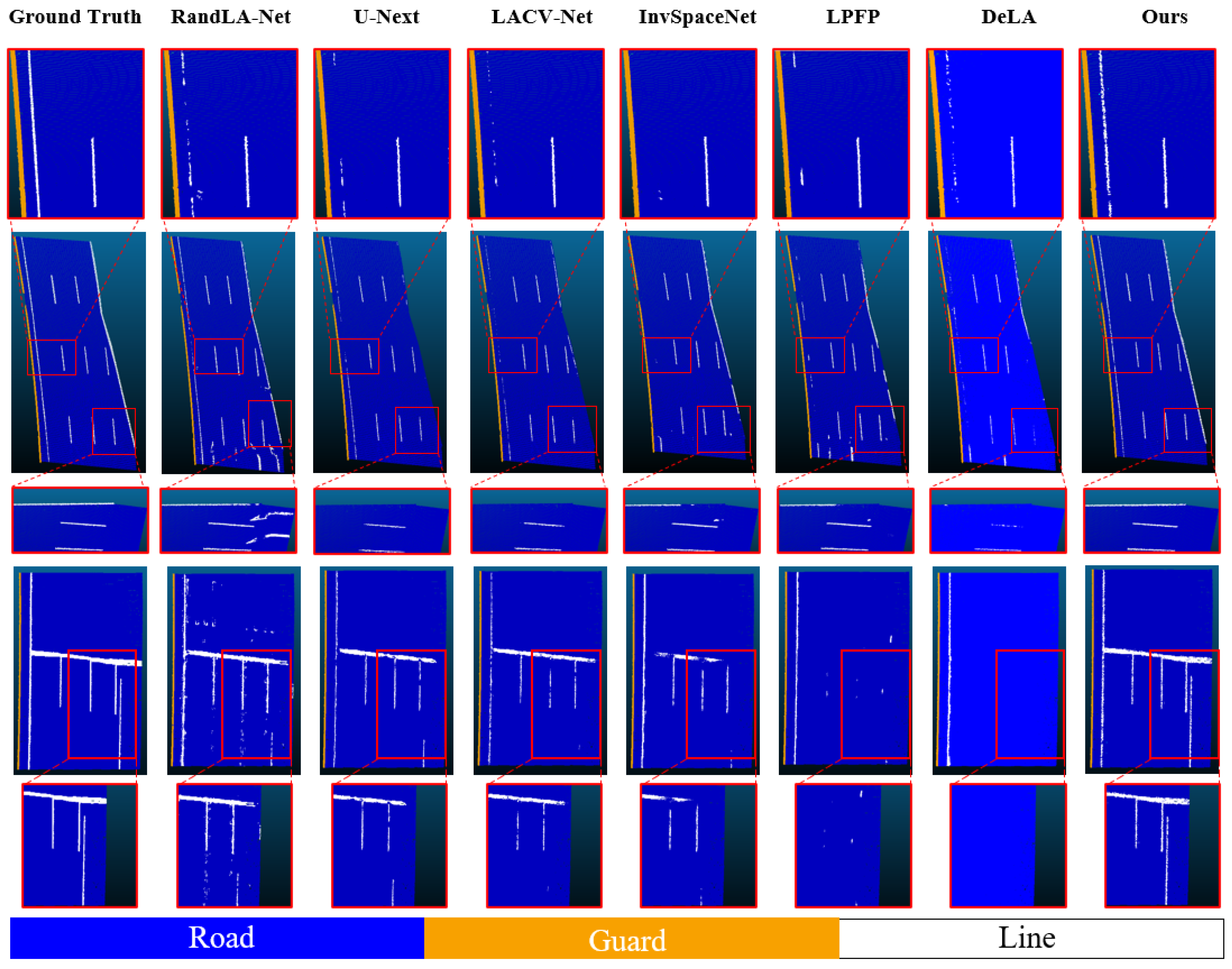
Table 2 reports the class-wise IoU comparison between the proposed method and existing point cloud semantic segmentation methods on the MLS dataset. Figure 5 shows the visual segmentation results of different methods in road scenes. As shown in Table 2, the proposed method achieves IoU scores of 97.6% and 98.9% on the Line and Guard categories, respectively, which are the best results among all compared methods. Although the proposed method does not achieve the best result on the Lamp category, it still maintains high segmentation accuracy. The visual results in Figure 5 show that some compared methods suffer from discontinuity in lane line regions, boundary adhesion, and confusion between road and line, whereas the proposed method generates more continuous and clearer lane line segmentation results and significantly reduces the erroneous absorption of lane line regions by road regions. This indicates that the proposed dilated local geometric encoding mechanism provides more sufficient multi-scale spatial contextual connections for linear objects, enabling the model to make predictions not only based on local point distributions but also by considering the relative positions between lane lines and surrounding road planes. The proposed method achieves the best IoU on the Guard category, indicating that the model can effectively capture continuous boundaries and local structural variations in slender objects. For categories such as Sign and Road, the proposed method also maintains stable performance. The Sign category usually has relatively clear local structures and semantic boundaries. The proposed method achieves an IoU of 99.2% on this category, which is comparable to the best-performing method, indicating that the proposed feature aggregation strategy maintains strong discriminability for small-scale objects. Road is a dominant category with a large proportion of points and continuous spatial distribution. The proposed method is only slightly lower than LPFP and InvSpaceNet on the Road category, while achieving clear improvements on categories such as Line and Guard. This shows that the category-boundary sampling strategy does not improve minority-category performance by significantly weakening the dominant category. The experimental results on the MLS dataset verify the segmentation effectiveness of the proposed method for large-scale point cloud data acquired by MLS and demonstrate that the proposed method effectively alleviates boundary confusion in long-tail categories.
Table 2.
Comparison of Single-Class IoU Results between Ours and Other Point Cloud Segmentation Methods in Test Regions.
Figure 5.
Visual comparison of semantic segmentation results on the MLS dataset.
4.3.2. Comparison on Toronto3D
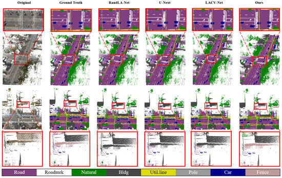
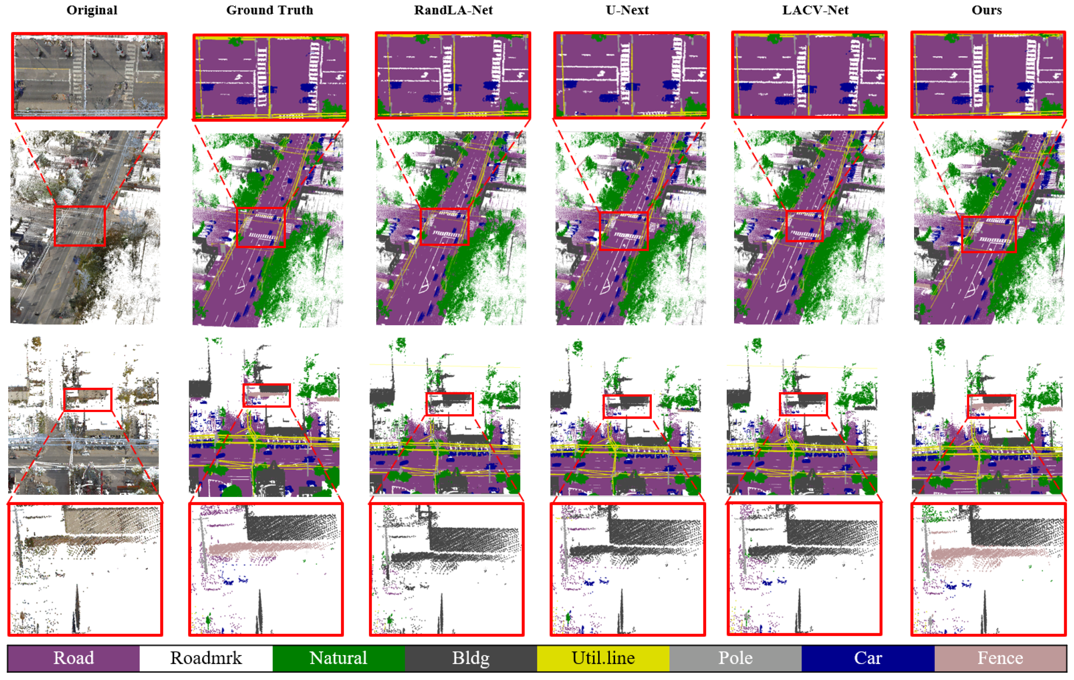
To further verify the effectiveness of the proposed method in large-scale outdoor point cloud scenes, this paper conducts comparative experiments with several advanced point cloud semantic segmentation methods on the Toronto3D [1] dataset. The quantitative results are shown in Table 3, and the visual results are shown in Figure 6. As shown in Table 3, the proposed method achieves an mIoU of 84.1% on the Toronto3D dataset, outperforming all compared methods and achieving the best overall class-balanced performance. While significantly improving the segmentation performance of minority categories and slender objects, the proposed method does not cause a large decrease in the segmentation accuracy of other major categories. This indicates that the proposed model enhances the representation ability of long-tail categories while maintaining stable modeling of the overall semantic structure of the scene. The proposed method achieves an IoU of 90.8% on the road marking category, significantly outperforming all compared methods. The visual results in Figure 6 show that, compared with other methods, the proposed method generates more continuous and clearer segmentation results in crosswalk and road marking regions, with clearly reduced boundary adhesion and misclassification. Meanwhile, the proposed method achieves an IoU of 56.9% on the fence category, outperforming most compared methods. As observed in Figure 6, the proposed method better preserves object continuity and boundary structures in fence regions, indicating that the proposed category-boundary sampling strategy can preferentially retain geometrically salient key points during sampling and alleviate feature information loss in hierarchical down-sampling. The quantitative and visual results on the Toronto3D dataset jointly verify the effectiveness of the proposed method in large-scale outdoor point cloud semantic segmentation. The proposed method not only achieves the best mIoU, but also shows clear advantages on long-tail categories or slender structures such as road marking and fence, indicating that DCA-Net has strong class-balanced modeling ability and adaptability to outdoor scenes.
Table 3.
Comparative experimental results between our method and existing methods on the Toronto-3D dataset (test region L002).
Figure 6.
Visual comparison of semantic segmentation results on the Toronto3D dataset.
However, the Toronto3D results also show that DCA-Net still has limitations in several categories. As shown in Table 3, although DCA-Net achieves the highest mIoU and obtains a clear advantage on the road marking category, its IoU on building is 77.3%, which is lower than most compared methods, and its IoU on natural is also lower than several baseline models. This suggests that the proposed method is more effective for slender or boundary-sensitive objects such as road markings and fences, but it may be less advantageous for large-area categories with complex surface variations. In the visual comparison in Figure 6, DCA-Net produces more continuous road marking segmentation and better preserves fence boundaries, whereas large planar or vegetation-like regions may still contain local ambiguities. One possible reason is that building and natural categories have broad spatial extents and diverse local geometric patterns, and their boundaries with surrounding objects may not always be sufficiently characterized by local geometric relationships alone. In addition, since the current model mainly uses geometric information, the absence of additional radiometric attributes, such as intensity, may limit its discriminative ability for categories with similar geometric structures.
4.3.3. Comparison on S3DIS
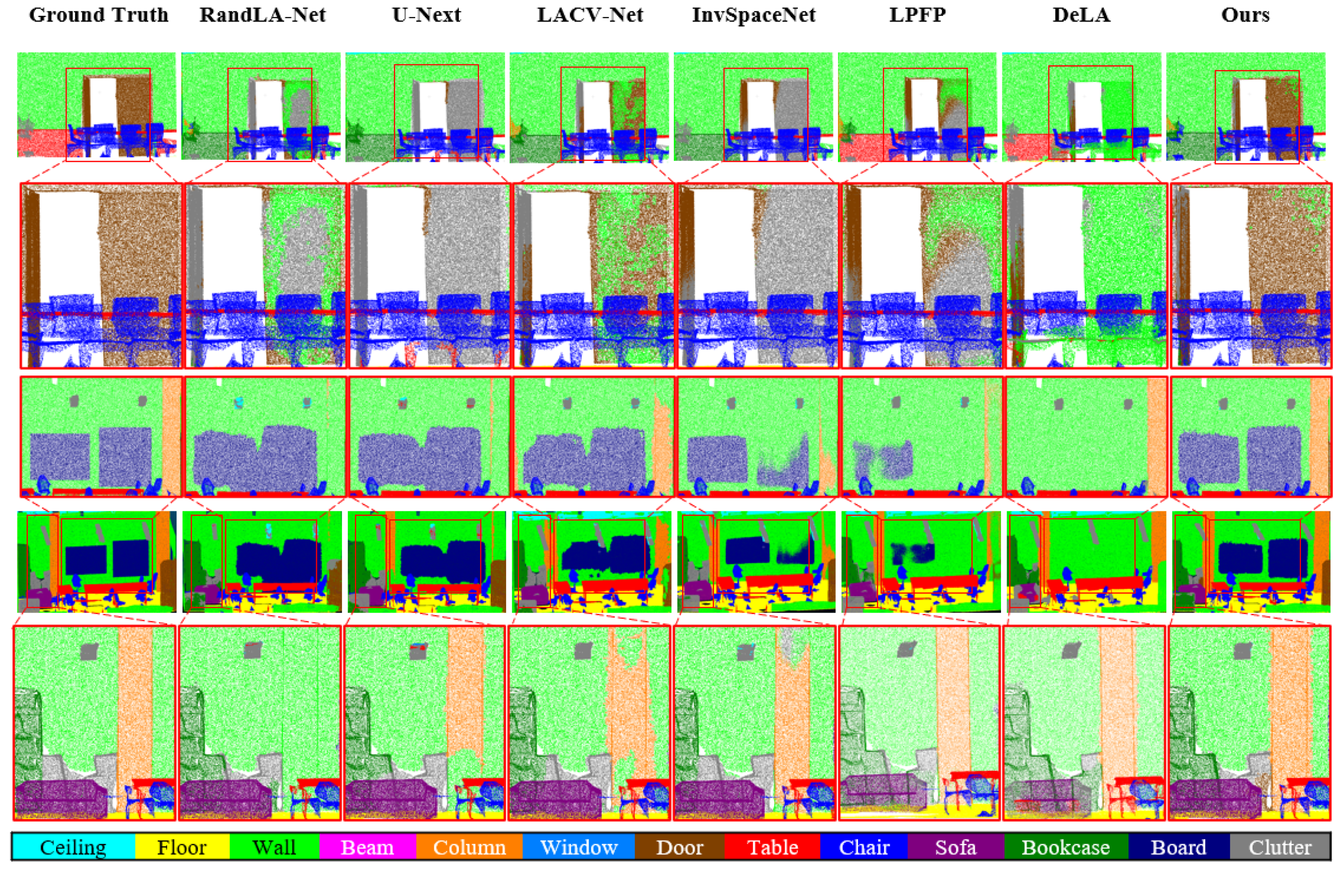
Table 4 reports the validation results of the proposed method and existing representative methods on the S3DIS dataset. Figure 7 shows the semantic segmentation visualization results of different methods in typical indoor scenes, where red boxes highlight regions in which other methods tend to produce misclassification or unclear boundaries. As shown in Table 4, the proposed method achieves an OA of 89.3% and an mIoU of 69.4%, outperforming most compared methods in terms of mIoU. Compared with RandLA-Net, BAAF-Net, LACV-Net, U-Next, and DeLA, the proposed method improves mIoU by 8.4, 3.0, 2.1, 2.5, and 2.3 percentage points, respectively. The visual results in Figure 7 further show that the proposed method generates more complete and continuous segmentation results on object boundaries, slender structures, and easily confused regions, with visibly fewer misclassified regions than other compared methods. The proposed method performs particularly well on minority categories such as column and easily confused categories such as board. Table 4 shows that the proposed method achieves the best IoU on both the column and board categories, indicating that the model can more effectively distinguish small-scale structures from their adjacent background categories. The red-box regions in Figure 7 also show that other methods tend to suffer from missing predictions, adhesion, or blurred boundaries around column boundaries and board regions, whereas the proposed method better preserves the structural integrity of objects. Although the proposed method is mainly designed for large-scale outdoor point cloud scenes acquired by MLS, the experimental results on the S3DIS indoor dataset show that it also has good generalization ability and semantic segmentation performance in indoor scenes with denser point distributions and more complex category shapes.
Table 4.
Comparative results between Ours and existing methods on S3DIS (Test region: Area-5).
Figure 7.
Visual comparison of semantic segmentation results on the S3DIS dataset.
The S3DIS results further indicate that the proposed method still has difficulty in some indoor categories. As shown in Table 4, DCA-Net achieves the best IoU on column and board, which is consistent with the visual observations in Figure 7 that the proposed method better preserves object boundaries and reduces missing predictions in the red-box regions. However, DCA-Net does not obtain the best results on several common indoor categories, such as ceiling, table, chair, sofa, bookcase, and clutter. This suggests that although DCA-Net is effective for boundary-sensitive and easily confused categories, its advantage is relatively limited for large planar regions or object categories with highly variable shapes. In the visual results in Figure 7, errors may still occur in cluttered regions where multiple objects are spatially adjacent or have similar local geometric patterns. These remaining errors may be caused by severe occlusion, dense object arrangements, and the limited discriminative information provided by local geometry alone. Therefore, incorporating richer contextual cues or additional point attributes may further improve the robustness of DCA-Net in complex indoor scenes.
4.4. Ablation Studies
To verify the effectiveness of the proposed modules, ablation experiments are conducted on the S3DIS dataset under the same training strategy and evaluation metrics. Table 5 reports the individual and joint contributions of DLGE, CAP, and CBS. A1 is the baseline model without the three proposed modules. A2, A3, and A4 introduce only DLGE, CBS, and CAP, respectively, to evaluate the independent contribution of each module. A5, A6, and A7 evaluate the pairwise combinations of the three modules, while A8 represents the complete DCA-Net with DLGE, CAP, and CBS simultaneously. As shown in Table 5, the baseline model A1 achieves an mIoU of 62.8%. When DLGE is introduced alone, A2 achieves an mIoU of 64.1%, improving the baseline by 1.3 percentage points. This indicates that DLGE enhances local geometric contextual modeling within fixed neighborhoods. When CBS is used alone, A3 achieves an mIoU of 63.1%, with a limited improvement of 0.3 percentage points. This suggests that sampling optimization alone cannot fully improve feature representation if the subsequent local feature extraction modules are not sufficiently enhanced. When CAP is introduced alone, A4 achieves an mIoU of 64.4%, improving the baseline by 1.6 percentage points, which shows that channel-wise feature recalibration helps strengthen effective semantic features. The pairwise combinations further demonstrate the complementarity among the proposed modules. A5 combines DLGE and CBS and achieves an mIoU of 67.9%, which is 5.1 percentage points higher than the baseline. A6 combines CAP and CBS and obtains an mIoU of 68.4%, with an improvement of 5.6 percentage points. These results indicate that CBS can better contribute to segmentation performance when it is combined with stronger local geometric encoding or channel-aware feature enhancement. In contrast, A7 combines DLGE and CAP without CBS and achieves an mIoU of 65.1%, improving the baseline by 2.3 percentage points. This result shows that although DLGE and CAP improve feature representation, the lack of category-boundary sampling still limits the preservation of long-tail category points and boundary points during point sampling. The complete model A8 achieves the best mIoU of 69.4%, outperforming the baseline by 6.6 percentage points. Compared with the pairwise variants, A8 also improves upon A5, A6, and A7 by 1.5, 1.0, and 4.3 percentage points, respectively. These results verify that DLGE, CAP, and CBS are complementary. DLGE strengthens local geometric context modeling, CAP enhances semantically effective channel responses, and CBS improves the preservation of long-tail and boundary points. Their joint use provides the most effective feature representation and sampling strategy, leading to the best semantic segmentation performance.
Table 5.
Ablation results on the S3DIS dataset.
5. Discussion
5.1. Effectiveness Analysis of the Proposed Method
The experimental results on three representative datasets show that the advantages of DCA-Net are mainly reflected in the accurate segmentation of long-tail categories, elongated objects, and boundary regions. On the MLS dataset, the segmentation results for lane lines and guardrails are more continuous, and the boundary confusion between roads and lane lines is substantially reduced. On the Toronto3D dataset, DCA-Net achieves favorable performance on categories such as road markings and fences. On the S3DIS dataset, small-scale or easily confused categories, such as columns and boards, are also more accurately recognized.
These observations indicate that the performance improvement of DCA-Net does not originate from a single dataset or a single category, but from the joint optimization of local structure preservation, channel-wise feature enhancement, and the sampling process. DLGE extends contextual interactions among points within a fixed neighborhood, enabling the model to exploit richer local geometric relationships. CAP enhances informative channel responses in neighborhood features and suppresses interference from redundant channels. CBS increases the retention probability of long-tail-category points and boundary points during sampling, thereby reducing the loss of critical structural information in hierarchical down-sampling.
5.2. Repeated-Run Stability Analysis
To reduce the influence of randomness and further evaluate the robustness of the reported performance, we repeated the experiments on the MLS dataset five times. In each run, the network was re-initialized and trained using the same data split, training protocol, and hyperparameter settings. In addition, we conducted statistical significance tests based on the repeated runs of DCA-Net to examine whether the observed performance improvement was statistically significant. As shown in Table 6, DCA-Net achieved an average OA of 99.1% and an average mIoU of 96.6%, with standard deviations of only 0.2% and 0.3%, respectively. The coefficient of variation for mIoU was 0.3%, indicating that the proposed method showed very small performance fluctuations across repeated runs. These repeated experiments further demonstrate the reliability and robustness of the proposed method.
Table 6.
Repeated-run results of DCA-Net on the MLS dataset.
5.3. Computational Efficiency Analysis
To further evaluate the practical feasibility of the proposed DCA-Net, we compared its computational efficiency with that of a representative baseline model under the same experimental environment on the MLS dataset. Table 7 reports the number of parameters, FLOPs, average inference time, peak GPU memory usage, and mIoU of the two methods. As shown in Table 7, DCA-Net achieves a higher mIoU of 96.6% while maintaining a moderate computational overhead. DCA-Net introduces more parameters and requires longer inference time and higher GPU memory usage, mainly due to the proposed DLGE and CAP modules. However, these additional costs are accompanied by a substantial improvement in segmentation accuracy. The results indicate that DCA-Net improves segmentation performance while maintaining acceptable computational efficiency. Although the proposed modules introduce a certain computational overhead compared with the lightweight RandLA-Net baseline, this overhead remains within a practical range and is well justified by the significant gain in mIoU. Therefore, DCA-Net provides a balanced solution between segmentation performance and computational efficiency for large-scale MLS point cloud semantic segmentation.
Table 7.
Computational efficiency comparison with representative baseline models.
5.4. Limitations and Future Work
Although DCA-Net achieves promising experimental results on multiple datasets, several limitations remain in the current study. First, the dilation parameters and neighborhood size in DLGE still need to be properly configured according to the scene scale and acquisition conditions, and fixed parameters may not maintain optimal performance across all scenarios. Therefore, designing a more adaptive neighborhood relation modeling mechanism remains an important issue for future research. Second, CBS relies on category statistics in the training set and boundary point determination results, and its generalization stability still requires further verification. In addition, although DCA-Net has been experimentally validated on two outdoor point cloud datasets, its generalization ability on more large-scale outdoor point cloud datasets remains to be further investigated.
Third, this study mainly evaluates boundary preservation through class-wise IoU and visual comparisons of boundary-sensitive categories, while unified boundary-specific metrics for 3D point cloud segmentation have not yet been introduced. Future research can further investigate more robust class-boundary sampling strategies and establish standardized evaluation protocols that include boundary point definition, tolerance distance, and boundary accuracy metrics. In addition, this study adopts XYZRGB six-channel point cloud inputs, thereby using both geometric coordinates and radiometric information associated with the point clouds. However, other point cloud attributes, such as intensity and scan angle rank, may still provide additional complementary information for distinguishing complex categories. Future research can explore effective fusion strategies for more point cloud attributes while maintaining the efficiency of the segmentation network, so as to further improve the semantic discrimination ability of the model in complex MLS scenes. Finally, the channel attention mechanism in CAP and the more complex local relation modeling in DLGE introduce additional computational overhead. Although the current efficiency experiments show that the computational cost of DCA-Net remains acceptable, further lightweight optimization is still needed for real-time mobile mapping, autonomous driving perception, or resource-constrained platforms. Future research will focus on more lightweight feature enhancement methods to improve the practical deployment efficiency of DCA-Net in large-scale MLS point cloud scenes.
6. Conclusions
This paper addresses boundary confusion in MLS point cloud semantic segmentation with long-tail categories and proposes the Dilated Context Attention Network, DCA-Net. The dilated local geometry encoding module, DLGE, expands point-to-point connections within fixed neighborhoods without changing the neighborhood search range, enriching contextual relationships among neighboring points and enabling the network to obtain more sufficient local structural information. The channel attention pooling module, CAP, enhances features before neighborhood aggregation, strengthens semantically relevant feature representations, and weakens the interference of redundant channels with effective features. The category-boundary sampling strategy, CBS, increases the sampling probabilities of long-tail category points and boundary points, reduces feature information loss during random sampling, and improves semantic segmentation accuracy. Experimental results on the MLS road scene dataset, the Toronto3D outdoor dataset, and the S3DIS indoor dataset show that DCA-Net effectively improves the segmentation accuracy of long-tail categories, slender objects, and boundary regions while maintaining stable overall segmentation performance.
Author Contributions
Conceptualization, B.D.; Methodology, B.D. and P.C.; Software, B.D., Z.Z. and P.C.; Validation, B.D., Z.Z. and P.C.; Formal analysis, B.D., Z.Z. and P.C.; Investigation, B.D.; Resources, B.D. and B.L.; Data curation, B.D., B.L. and P.C.; Writing – original draft, B.D., B.L., P.C. and Z.C.; Writing – review & editing, B.D., P.C. and Z.C.; Visualization, B.D. and Z.C.; Supervision, B.L. and Z.C.; Project administration, B.L. and Z.C.; Funding acquisition, B.L. and Z.C. All authors have read and agreed to the published version of the manuscript.
Funding
This research was funded by National Natural Science Foundation of China, grant number 42301532.
Data Availability Statement
Publicly available datasets were analyzed in this study. The S3DIS dataset is available from the Stanford Large-Scale Indoor Spaces 3D Dataset repository. The Toronto3D dataset is available from the corresponding public dataset source described in the original Toronto3D publication. The MLS road-scene dataset generated and analyzed during the current study is not publicly available due to institutional restrictions and data management requirements.
Conflicts of Interest
The authors declare no conflicts of interest.
References
- Tan, W.; Qin, N.; Ma, L.; Li, Y.; Du, J.; Cai, G.; Yang, K.; Li, J. Toronto-3D: A large-scale mobile LiDAR dataset for semantic segmentation of urban roadways. In Proceedings of the IEEE/CVF Conference on Computer Vision and Pattern Recognition Workshops, Seattle, WA, USA, 13–19 June 2020; pp. 202–203. [Google Scholar]
- Wang, Y.; Chen, Q.; Zhu, Q.; Liu, L.; Li, C.; Zheng, D. A survey of mobile laser scanning applications and key techniques over Urban Areas. Remote Sens. 2019, 11, 1540. [Google Scholar] [CrossRef] [Scilit]
- Zhao, J.; Wang, Y.; Cao, Y.; Guo, M.; Huang, X.; Zhang, R.; Dou, X.; Niu, X.; Cui, Y.; Wang, J. The Fusion Strategy of 2D and 3D Information Based on Deep Learning: A Review. Remote Sens. 2021, 13, 4029. [Google Scholar] [CrossRef] [Scilit]
- Wang, C.; Wen, C.; Dai, Y.; Yu, S.; Liu, M. Urban 3D modeling using mobile laser scanning: A Review. Virtual Real. Intell. Hardw. 2020, 2, 175–212. [Google Scholar] [CrossRef] [Scilit]
- Qi, C.R.; Su, H.; Mo, K.; Guibas, L.J. PointNet: Deep Learning on Point Sets for 3D Classification and Segmentation. In Proceedings of the 2017 IEEE Conference on Computer Vision and Pattern Recognition (CVPR), Honolulu, HI, USA, 21–26 July 2017; pp. 652–660. [Google Scholar] [CrossRef] [Scilit]
- Qi, C.R.; Yi, L.; Su, H.; Guibas, L.J. PointNet++: Deep Hierarchical Feature Learning on Point Sets in a Metric Space. In Proceedings of the Advances in Neural Information Processing Systems 30, Long Beach, CA, USA, 4–9 December 2017. [Google Scholar]
- Qian, G.; Li, Y.; Peng, H.; Mai, J.; Hammoud, H.; Elhoseiny, M.; Ghanem, B. Pointnext: Revisiting pointnet++ with improved training and scaling strategies. Adv. Neural Inf. Process. Syst. 2022, 35, 23192–23204. [Google Scholar] [CrossRef] [Scilit]
- Zhao, H.; Jiang, L.; Jia, J.; Torr, P.H.; Koltun, V. Point transformer. In Proceedings of the IEEE/CVF International Conference on Computer Vision, Montreal, QC, Canada, 10–17 October 2021; pp. 16259–16268. [Google Scholar]
- Guo, M.-H.; Cai, J.-X.; Liu, Z.-N.; Mu, T.-J.; Martin, R.R.; Hu, S.-M. Pct: Point cloud transformer. Comput. Vis. Media 2021, 7, 187–199. [Google Scholar] [CrossRef] [Scilit]
- Wu, X.; Jiang, L.; Wang, P.-S.; Liu, Z.; Liu, X.; Qiao, Y.; Ouyang, W.; He, T.; Zhao, H. Point transformer v3: Simpler faster stronger. In Proceedings of the IEEE/CVF Conference on Computer Vision and Pattern Recognition, Seattle, WA, USA, 16–22 June 2024; pp. 4840–4851. [Google Scholar]
- Wu, X.; Lao, Y.; Jiang, L.; Liu, X.; Zhao, H. Point transformer v2: Grouped vector attention and partition-based pooling. Adv. Neural Inf. Process. Syst. 2022, 35, 33330–33342. [Google Scholar] [CrossRef] [Scilit]
- Hu, Q.; Yang, B.; Xie, L.; Rosa, S.; Guo, Y.; Wang, Z.; Trigoni, N.; Markham, A. Learning Semantic Segmentation of Large-Scale Point Clouds with Random Sampling. IEEE Trans. Pattern Anal. Mach. Intell. 2022, 44, 8338–8354. [Google Scholar] [CrossRef] [Scilit] [PubMed]
- Li, Y.; Bu, R.; Sun, M.; Wu, W.; Di, X.; Chen, B. PointCNN: Convolution on X-Transformed Points. In Proceedings of the Advances in Neural Information Processing Systems 31, Montreal, QC, Canada, 3–8 December 2018. [Google Scholar]
- Lin, Y.; Yan, Z.; Huang, H.; Du, D.; Liu, L.; Cui, S.; Han, X. Fpconv: Learning local flattening for point convolution. In Proceedings of the IEEE/CVF Conference on Computer Vision and Pattern Recognition, Seattle, WA, USA, 13–19 June 2020; pp. 4293–4302. [Google Scholar]
- Tang, H.; Liu, Z.; Zhao, S.; Lin, Y.; Lin, J.; Wang, H.; Han, S. Searching efficient 3d architectures with sparse point-voxel convolution. In Proceedings of the European Conference on Computer Vision, Glasgow, UK, 23–28 August 2020; pp. 685–702. [Google Scholar]
- Wu, W.; Qi, Z.; Fuxin, L. Pointconv: Deep convolutional networks on 3d point clouds. In Proceedings of the IEEE/CVF Conference on Computer Vision and Pattern Recognition, Long Beach, CA, USA, 16–20 June 2019; pp. 9621–9630. [Google Scholar]
- Xu, M.; Ding, R.; Zhao, H.; Qi, X. Paconv: Position adaptive convolution with dynamic kernel assembling on point clouds. In Proceedings of the IEEE/CVF Conference on Computer Vision and Pattern Recognition, Nashville, TN, USA, 19–25 June 2021; pp. 3173–3182. [Google Scholar]
- Liu, Z.; Tang, H.; Lin, Y.; Han, S. Point-Voxel CNN for Efficient 3D Deep Learning. In Proceedings of the Advances in Neural Information Processing Systems 32, Vancouver, BC, Canada, 8–14 December 2019. [Google Scholar]
- Thomas, H.; Qi, C.R.; Deschaud, J.-E.; Marcotegui, B.; Goulette, F.; Guibas, L.J. Kpconv: Flexible and deformable convolution for point clouds. In Proceedings of the IEEE/CVF International Conference on Computer Vision, Seoul, Republic of Korea, 27 October–2 November 2019; pp. 6411–6420. [Google Scholar]
- Xu, C.; Wu, B.; Wang, Z.; Zhan, W.; Vajda, P.; Keutzer, K.; Tomizuka, M. Squeezesegv3: Spatially-adaptive convolution for efficient point-cloud segmentation. In Proceedings of the European Conference on Computer Vision, Glasgow, UK, 23–28 August 2020; pp. 1–19. [Google Scholar]
- Chen, J.; Zhao, Y.; Meng, C.; Liu, Y. Multi-feature aggregation for semantic segmentation of an urban scene point cloud. Remote Sens. 2022, 14, 5134. [Google Scholar] [CrossRef] [Scilit]
- Zhang, J.; Yan, J. RandLA-Net++: A Large-Scale Point Cloud Segmentation Method for Autonomous Driving. In Proceedings of the 2025 IEEE International Conference on Systems, Man, and Cybernetics (SMC), Vienna, Austria, 5–8 October 2025; pp. 2066–2072. [Google Scholar] [CrossRef] [Scilit]
- Wang, X.; Yuan, Y. MNAT-Net: Multi-Scale Neighborhood Aggregation Transformer Network for Point Cloud Classification and Segmentation. IEEE Trans. Intell. Transp. Syst. 2024, 25, 9153–9167. [Google Scholar] [CrossRef] [Scilit]
- Zeng, Z.; Qiu, H.; Zhou, J.; Dong, Z.; Xiao, J.; Li, B. PointNAT: Large-Scale Point Cloud Semantic Segmentation via Neighbor Aggregation with Transformer. IEEE Trans. Geosci. Remote Sens. 2024, 62, 5704618. [Google Scholar] [CrossRef] [Scilit]
- Fan, S.; Dong, Q.; Zhu, F.; Lv, Y.; Ye, P.; Wang, F.-Y. SCF-Net: Learning spatial contextual features for large-scale point cloud segmentation. In Proceedings of the IEEE/CVF Conference on Computer Vision and Pattern Recognition, Nashville, TN, USA, 19–25 June 2021; pp. 14504–14513. [Google Scholar]
- Vaswani, A.; Shazeer, N.; Parmar, N.; Uszkoreit, J.; Jones, L.; Gomez, A.N.; Kaiser, Ł.; Polosukhin, I. Attention Is All You Need. In Proceedings of the Advances in Neural Information Processing Systems 30, Long Beach, CA, USA, 4–9 December 2017. [Google Scholar]
- Lai, X.; Liu, J.; Jiang, L.; Wang, L.; Zhao, H.; Liu, S.; Qi, X.; Jia, J. Stratified transformer for 3d point cloud segmentation. In Proceedings of the IEEE/CVF Conference on Computer Vision and Pattern Recognition, New Orleans, LA, USA, 18–24 June 2022; pp. 8500–8509. [Google Scholar]
- Park, C.; Jeong, Y.; Cho, M.; Park, J. Fast point transformer. In Proceedings of the IEEE/CVF Conference on Computer Vision and Pattern Recognition, New Orleans, LA, USA, 18–24 June 2022; pp. 16949–16958. [Google Scholar]
- Wang, P.-S. OctFormer: Octree-Based Transformers for 3D Point Clouds. ACM Trans. Graph. 2023, 42, 1–11. [Google Scholar] [CrossRef] [Scilit]
- Han, J.; Liu, K.; Li, W.; Chen, G.; Wang, W.; Zhang, F. A large-scale network construction and lightweighting method for point cloud semantic segmentation. IEEE Trans. Image Process. 2024, 33, 2004–2017. [Google Scholar] [CrossRef] [Scilit] [PubMed]
- Sun, T.; Zhang, Z.; Tan, X.; Qu, Y.; Xie, Y. Image understands point cloud: Weakly supervised 3D semantic segmentation via association learning. IEEE Trans. Image Process. 2024, 33, 1838–1852. [Google Scholar] [CrossRef] [Scilit] [PubMed]
- Xu, X.; Lee, G.H. Weakly supervised semantic point cloud segmentation: Towards 10x fewer labels. In Proceedings of the IEEE/CVF Conference on Computer Vision and Pattern Recognition, Seattle, WA, USA, 14–19 June 2020; pp. 13706–13715. [Google Scholar]
- Zhang, Y.; Li, Z.; Xie, Y.; Qu, Y.; Li, C.; Mei, T. Weakly supervised semantic segmentation for large-scale point cloud. In Proceedings of the AAAI Conference on Artificial Intelligence, Virtual, 2–9 February 2021; pp. 3421–3429. [Google Scholar]
- Zhao, N.; Chua, T.-S.; Lee, G.H. Few-shot 3d point cloud semantic segmentation. In Proceedings of the IEEE/CVF Conference on Computer Vision and Pattern Recognition, Nashville, TN, USA, 20–25 June 2021; pp. 8873–8882. [Google Scholar]
- He, S.; Jiang, X.; Jiang, W.; Ding, H. Prototype adaption and projection for few-and zero-shot 3d point cloud semantic segmentation. IEEE Trans. Image Process. 2023, 32, 3199–3211. [Google Scholar] [CrossRef] [Scilit] [PubMed]
- Wang, Y.; Sun, Y.; Liu, Z.; Sarma, S.E.; Bronstein, M.M.; Solomon, J.M. Dynamic Graph CNN for Learning on Point Clouds. ACM Trans. Graph. 2019, 38, 1–12. [Google Scholar] [CrossRef] [Scilit]
- Zhao, H.; Jiang, L.; Fu, C.-W.; Jia, J. Pointweb: Enhancing local neighborhood features for point cloud processing. In Proceedings of the IEEE/CVF Conference on Computer Vision and Pattern Recognition, Long Beach, CA, USA, 16–20 June 2019; pp. 5565–5573. [Google Scholar]
- Liu, Y.; Fan, B.; Xiang, S.; Pan, C. Relation-shape convolutional neural network for point cloud analysis. In Proceedings of the IEEE/CVF Conference on Computer Vision and Pattern Recognition, Long Beach, CA, USA, 16–20 June 2019; pp. 8895–8904. [Google Scholar]
- Liu, Y.; Fan, B.; Meng, G.; Lu, J.; Xiang, S.; Pan, C. Densepoint: Learning densely contextual representation for efficient point cloud processing. In Proceedings of the IEEE/CVF International Conference on Computer Vision, Seoul, Republic of Korea, 27 October–2 November 2019; pp. 5239–5248. [Google Scholar]
- Engelmann, F.; Kontogianni, T.; Leibe, B. Dilated point convolutions: On the receptive field size of point convolutions on 3d point clouds. In Proceedings of the 2020 IEEE International Conference on Robotics and Automation (ICRA), Paris, France, 31 May–31 August 2020; pp. 9463–9469. [Google Scholar]
- Yan, X.; Zheng, C.; Li, Z.; Wang, S.; Cui, S. Pointasnl: Robust point clouds processing using nonlocal neural networks with adaptive sampling. In Proceedings of the IEEE/CVF Conference on Computer Vision and Pattern Recognition, Seattle, WA, USA, 13–19 June 2020; pp. 5589–5598. [Google Scholar]
- Wang, L.; Huang, Y.; Hou, Y.; Zhang, S.; Shan, J. Graph Attention Convolution for Point Cloud Semantic Segmentation. In Proceedings of the IEEE/CVF Conference on Computer Vision and Pattern Recognition (CVPR), Long Beach, CA, USA, 15–20 June 2019; pp. 10296–10305. [Google Scholar] [CrossRef] [Scilit]
- Luo, L.; Lu, J.; Chen, X.; Zhang, K.; Zhou, J. LSGRNet: Local spatial latent geometric relation learning network for 3D point cloud semantic segmentation. Comput. Graph. 2024, 124, 104053. [Google Scholar] [CrossRef] [Scilit]
- Feng, M.; Zhang, L.; Lin, X.; Gilani, S.Z.; Mian, A. Point attention network for semantic segmentation of 3D point clouds. Pattern Recognit. 2020, 107, 107446. [Google Scholar] [CrossRef] [Scilit]
- Han, W.; Wen, C.; Wang, C.; Li, X.; Li, Q. Point2node: Correlation learning of dynamic-node for point cloud feature modeling. In Proceedings of the AAAI Conference on Artificial Intelligence, New York, NY, USA, 7–12 February 2020; pp. 10925–10932. [Google Scholar]
- Huang, Z.; Wang, X.; Huang, L.; Huang, C.; Wei, Y.; Liu, W. Ccnet: Criss-cross attention for semantic segmentation. In Proceedings of the IEEE/CVF International Conference on Computer Vision, Seoul, Republic of Korea, 27 October–2 November 2019; pp. 603–612. [Google Scholar]
- Fu, J.; Liu, J.; Tian, H.; Li, Y.; Bao, Y.; Fang, Z.; Lu, H. Dual attention network for scene segmentation. In Proceedings of the IEEE/CVF Conference on Computer Vision and Pattern Recognition, Long Beach, CA, USA, 15–20 June 2019; pp. 3146–3154. [Google Scholar]
- Zhao, H.; Zhang, Y.; Liu, S.; Shi, J.; Loy, C.C.; Lin, D.; Jia, J. Psanet: Point-wise spatial attention network for scene parsing. In Proceedings of the European Conference on Computer Vision (ECCV), Munich, Germany, 8–14 September 2018; pp. 267–283. [Google Scholar]
- Woo, S.; Park, J.; Lee, J.-Y.; Kweon, I.S. Cbam: Convolutional block attention module. In Proceedings of the European Conference on Computer Vision (ECCV), Munich, Germany, 8–14 September 2018; pp. 3–19. [Google Scholar]
- Wang, Q.; Wu, B.; Zhu, P.; Li, P.; Zuo, W.; Hu, Q. ECA-Net: Efficient channel attention for deep convolutional neural networks. In Proceedings of the IEEE/CVF Conference on Computer Vision and Pattern Recognition, Seattle, WA, USA, 13–19 June 2020; pp. 11534–11542. [Google Scholar]
- Lu, H.; Chen, X.; Zhang, G.; Zhou, Q.; Ma, Y.; Zhao, Y. SCANet: Spatial-channel attention network for 3D object detection. In Proceedings of the ICASSP 2019 IEEE International Conference on Acoustics, Speech and Signal Processing (ICASSP), Brighton, UK, 12–17 May 2019; pp. 1992–1996. [Google Scholar] [CrossRef] [Scilit]
- Armeni, I.; Sener, O.; Zamir, A.R.; Jiang, H.; Brilakis, I.; Fischer, M.; Savarese, S. 3d semantic parsing of large-scale indoor spaces. In Proceedings of the IEEE Conference on Computer Vision and Pattern Recognition, Las Vegas, NV, USA, 27–30 June 2016; pp. 1534–1543. [Google Scholar]
- Qiu, S.; Anwar, S.; Barnes, N. Semantic segmentation for real point cloud scenes via bilateral augmentation and adaptive fusion. In Proceedings of the IEEE/CVF Conference on Computer Vision and Pattern Recognition, Nashville, TN, USA, 19–25 June 2021; pp. 1757–1767. [Google Scholar]
- Shuai, H.; Xu, X.; Liu, Q. Backward attentive fusing network with local aggregation classifier for 3D point cloud semantic segmentation. IEEE Trans. Image Process. 2021, 30, 4973–4984. [Google Scholar] [CrossRef] [Scilit] [PubMed]
- Zeng, Z.; Xu, Y.; Xie, Z.; Tang, W.; Wan, J.; Wu, W. Large-scale point cloud semantic segmentation via local perception and global descriptor vector. Expert Syst. Appl. 2024, 246, 123269. [Google Scholar] [CrossRef] [Scilit]
- Zeng, Z.; Hu, Q.; Xie, Z.; Li, B.; Zhou, J.; Xu, Y. Small but Mighty: Enhancing 3D Point Clouds Semantic Segmentation with U-Next Framework. Int. J. Appl. Earth Obs. Geoinf. 2025, 136, 104309. [Google Scholar] [CrossRef] [Scilit]
- Yang, W.; Lu, X.; Chen, B.; Lin, C.; Bao, X.; Liu, W.; Zang, Y.; Xu, J.; Wang, C. DeLA: An Extremely Faster Network with Decoupled Local Aggregation for Large Scale Point Cloud Learning. Int. J. Appl. Earth Obs. Geoinf. 2024, 135, 104255. [Google Scholar] [CrossRef] [Scilit]
- Han, J.; Liu, K.; Li, W.; Zhang, F.; Xia, X.-G. Generating inverse feature space for class imbalance in point cloud semantic segmentation. IEEE Trans. Pattern Anal. Mach. Intell. 2025, 47, 5778–5793. [Google Scholar] [CrossRef] [Scilit] [PubMed]
- Du, J.; Cai, G.; Wang, Z.; Huang, S.; Su, J.; Junior, J.M.; Smit, J.; Li, J. ResDLPS-Net: Joint residual-dense optimization for large-scale point cloud semantic segmentation. ISPRS J. Photogramm. Remote Sens. 2021, 182, 37–51. [Google Scholar] [CrossRef] [Scilit]
- Zeng, Z.; Xu, Y.; Xie, Z.; Wan, J.; Wu, W.; Dai, W. RG-GCN: A random graph based on graph convolution network for point cloud semantic segmentation. Remote Sens. 2022, 14, 4055. [Google Scholar] [CrossRef] [Scilit]
- Xu, Y.; Tang, W.; Zeng, Z.; Wu, W.; Wan, J.; Guo, H.; Xie, Z. NeiEA-NET: Semantic segmentation of large-scale point cloud scene via neighbor enhancement and aggregation. Int. J. Appl. Earth Obs. Geoinf. 2023, 119, 103285. [Google Scholar] [CrossRef] [Scilit]
- Yoo, S.; Jeong, Y.; Jameela, M.; Sohn, G. Human Vision Based 3D Point Cloud Semantic Segmentation of Large-Scale Outdoor Scenes. In Proceedings of the 2023 IEEE/CVF Conference on Computer Vision and Pattern Recognition Workshops (CVPRW), Vancouver, BC, Canada, 17–24 June 2023; pp. 6577–6586. [Google Scholar] [CrossRef] [Scilit]
- Zhang, J.; Jiang, Z.; Qiu, Q.; Liu, Z. TCFAP-Net: Transformer-based cross-feature fusion and adaptive perception network for large-scale point cloud semantic segmentation. Pattern Recognit. 2024, 154, 110630. [Google Scholar] [CrossRef] [Scilit]
- Xia, J.; Chen, Y.; Li, G.; Shen, Y.; Zou, X.; Chen, D.; Zang, Y. PGFormer: A point cloud segmentation network for urban scenes combining grouped transformer and KPConv. IEEE Trans. Geosci. Remote Sens. 2025, 63, 5704318. [Google Scholar] [CrossRef] [Scilit]
- Lu, D.; Xu, L.; Zhou, J.; Gao, K.Y.; Li, J. 3DLST: 3D Learnable Supertoken Transformer for LiDAR point cloud scene segmentation. Int. J. Appl. Earth Obs. Geoinf. 2025, 140, 104572. [Google Scholar] [CrossRef] [Scilit]
- Akwensi, P.H.; Wang, R.; Guo, B. PReFormer: A Memory-Efficient Transformer for Point Cloud Semantic Segmentation. Int. J. Appl. Earth Obs. Geoinf. 2024, 128, 103730. [Google Scholar] [CrossRef] [Scilit]
- Bayrak, O.C.; Uzar, M. Local Contextual Attention for Enhancing Kernel Point Convolution in 3D Point Cloud Semantic Segmentation. Appl. Sci. 2025, 15, 9503. [Google Scholar] [CrossRef] [Scilit]
- Landrieu, L.; Simonovsky, M. Large-scale point cloud semantic segmentation with superpoint graphs. In Proceedings of the IEEE Conference on Computer Vision and Pattern Recognition, Salt Lake City, UT, USA, 18–22 June 2018; pp. 4558–4567. [Google Scholar]
- Du, Z.; Ye, H.; Cao, F. A Novel Local-Global Graph Convolutional Method for Point Cloud Semantic Segmentation. IEEE Trans. Neural Netw. Learn. Syst. 2024, 35, 4798–4812. [Google Scholar] [CrossRef] [Scilit] [PubMed]

Disclaimer/Publisher’s Note: The statements, opinions and data contained in all publications are solely those of the individual author(s) and contributor(s) and not of MDPI and/or the editor(s). MDPI and/or the editor(s) disclaim responsibility for any injury to people or property resulting from any ideas, methods, instructions or products referred to in the content. |
© 2026 by the authors. Licensee MDPI, Basel, Switzerland. This article is an open access article distributed under the terms and conditions of the Creative Commons Attribution (CC BY) license.