


Highlights
What are the main findings?
- Multi-population based differential evolution refines the TLS–UAV registration of the Hasaköy (Sasima) Church to a 30-run median bidirectional trimmed RMSE of 0.3718 m, below the TR-ICP (0.4152 m), PSO, and Aquila Optimizer baselines under the same 6-DoF budget.
- Six-degree-of-freedom decomposition shows the residual adjustment concentrates near a 3.4° vertical-axis rotation and a 0.71 m translation norm.
What are the implications of the main findings?
- A parameter-light, training-free optimization framework supports reproducible highfidelity 3D documentation of partially overlapping multi-sensor heritage sites.
- Reporting bidirectional trimmed RMSE alongside facade-overlap accuracy and UAV block control avoids conflating decimeter-scale cross-source distances with centimeterscale sensor precision.
Abstract
The digital preservation of built cultural heritage requires precise documentation techniques capable of capturing complex architectural geometries often affected by occlusions and data voids. This study presents a robust multi-sensor fusion workflow integrating Terrestrial Laser Scanning (TLS) and Unmanned Aerial Vehicle (UAV) photogrammetry for the 3D reconstruction of the Hasaköy (Sasima) Church in Niğde, Türkiye. To address the limitations of traditional registration methods, specifically the susceptibility of the Iterative Closest Point (ICP) algorithm to local minima in datasets with partial overlaps, this study proposes a fine-tuning approach based on the Multi-population Based Differential Evolution (MDE) algorithm. The methodology employs a coarse-to-fine strategy, initiating with Fast Point Feature Histogram (FPFH) extraction and RANSAC (Random Sample Consensus) for global alignment, followed by TR-ICP, MDE, PSO, and Aquila Optimizer (AO) evaluation, computational-time analysis, FPFH-radius sensitivity testing, and 6-DoF transformation decomposition to characterize both accuracy and operational cost. In the 30-run fine-tuning evaluation, MDE reduced the mean bidirectional trimmed RMSE from 0.4152 m for TR-ICP to 0.3726 m. With a population parameter of 10, MDE retained a low median RMSE of 0.3718 m, while PSO exhibited a wider stochastic tail under the same bounded 6-DoF search budget. AO produced a higher mean bidirectional trimmed RMSE of 0.5233 m. The decimeter-scale bidirectional RMSE should be interpreted as a cross-source, partial-overlap distance metric rather than sensor precision; the overlapping facade objective was approximately 2.4–2.8 cm, and the UAV block was independently controlled with a 1.34 cm GCP RMSE. This study establishes a transparent and reproducible framework for heritage documentation, supporting the faithful digital preservation of endangered monuments with complex typologies.
1. Introduction
The preservation of built cultural heritage is increasingly critical as historic structures face constant threats from environmental pressures, anthropogenic damage, and structural degradation [1]. To ensure the protection and longevity of these monuments, understanding their preservation state through precise documentation is essential [2,3]. In recent years, reverse engineering technology and 3D reconstruction have become pivotal in modern industrial design and heritage conservation, allowing experts to transition from physical reality to digital preservation [4,5,6]. Specifically, the rapid development of “reality capture” technologies, such as photogrammetry and laser scanning, has enabled the creation of dimensionally accurate 3D models that serve as tangible links to the past [7,8].
However, documenting complex historic architectures presents significant challenges when relying on a single sensor. Terrestrial Laser Scanning (TLS) is widely recognized for generating high-density, reliable 3D point clouds with millimetric accuracy [9,10]. Despite these strengths, TLS is limited by its line-of-sight nature, often resulting in significant data voids, particularly on roofs and upper building zones that are inaccessible from the ground [11,12]. Conversely, Unmanned Aerial Vehicle (UAV) photogrammetry offers a cost-effective and flexible solution for capturing large areas and horizontal surfaces like roofs, yet it often lacks the terrestrial detail and geometric precision of TLS on vertical facades [8,11]. Recent studies emphasize that for vertical historical structures, compensating for ground-based blind spots with aerial sensors is crucial not only for geometric completeness but also for symmetry assessment and Heritage Building Information Modeling (HBIM) workflows [13]. Consequently, the integration of multi-source data, fusing the high-precision terrestrial detail of TLS with the comprehensive aerial coverage of UAVs, has become a standard workflow to ensure model completeness and integrity [10,14,15].
The fundamental challenge in multi-sensor fusion lies in the accurate registration of these disparate point clouds. The aim is to align datasets into a unified coordinate system, a process traditionally handled by the Iterative Closest Point (ICP) algorithm [16]. While ICP remains a prevalent tool for fine registration [17], it faces severe limitations documented extensively in recent literature. A primary deficiency is its susceptibility to local minima; if the initial positions of the point clouds are not already roughly aligned, the algorithm frequently fails to converge to the global optimum [18,19,20]. Furthermore, standard ICP approaches struggle with the uneven point distribution, noise, and partial overlaps inherent in fusing TLS and UAV data [21,22,23]. Researchers have noted that ICP assumes a point-to-point correspondence based on Euclidean distance, which can lead to incorrect matches and slow convergence speeds when handling the massive datasets typical of heritage sites [6,24,25]. Recent experimental studies have confirmed these shortcomings, demonstrating that in challenging UAV-TLS fusion scenarios involving complex geometries, standard automatic ICP approaches can fail to converge, resulting in significant misalignment errors [26].
To address these shortcomings, the research community has increasingly turned toward heuristic and metaheuristic optimization algorithms. These “swarm intelligence” methods mimic natural phenomena to perform global searches, effectively avoiding the local minima traps that hinder gradient-based methods like ICP [19,24]. Various algorithms have been proposed to enhance registration robustness, including Particle Swarm Optimization (PSO) [27], Aquila Optimizer (AO) [28], Artificial Rabbits Optimization (ARO) [29], and Artificial Bee Colony (ABC) [30], Whale Optimization [6], and Northern Goshawk Optimization [17]. Among these evolutionary strategies, Differential Evolution (DE) has emerged as a robust candidate for solving complex optimization problems [20]. However, standard DE often requires time-consuming tuning of mutation and crossover parameters, which limits its universality [31]. To overcome this, the Multi-population Based Differential Evolution (MDE) algorithm provides a robust and parameter-light alternative for complex search problems. MDE utilizes a power-law-based scale-invariant strategy to effectively escape local minima and features a parameter-free structure that eliminates the need for complex internal adjustments [31]. Recent comparative studies indicate that MDE can achieve competitive performance compared with other heuristic methods such as PSO, ABC, and Grey Wolf Optimizer (GWO) in terms of both convergence speed and robustness, particularly in complex spatial optimization tasks [32].
Learning-based point cloud registration networks, including PointNetLK, Deep Closest Point, PREDATOR, and GeoTransformer, have also advanced the field by learning feature representations and overlap-aware correspondences [33,34,35,36]. However, their direct use in this cultural heritage case is limited by the absence of site-specific training pairs, the strong domain shift between terrestrial laser scanning and UAV photogrammetry, the irregular density and low-overlap roof-facade geometry, and the need for an auditable optimization process in conservation documentation. For this reason, the present study focuses on a training-free heuristic optimization scheme that can be applied to a single monument without constructing a dedicated learning dataset, while learning-based registration remains an important future benchmark when representative heritage training corpora become available.
This study focuses on the 3D documentation of the Hasaköy (Sasima) Church in Niğde, Türkiye, a site characterized by complex architectural features that necessitate a fusion of terrestrial and aerial data. This monumental structure, constructed in 1848 by the architect Gregor Kalfa and dedicated to St. Stephanos, serves as a significant example of 19th-century Christian architecture in the Cappadocia region [37,38]. Classified as “Type 1G” in typomorphological analyses, the church features a three-nave basilica plan with three apses and a distinctive U-shaped narthex covered by cross vaults [37]. The structure is primarily built from black and grey basalt stone with walls reaching thicknesses of up to 2 m, presenting unique challenges for optical sensors due to the material’s texture and light absorption properties [39,40]. While the historical significance of Sasima is well established, notably as the bishopric seat assigned to Gregory of Nazianzus by Basil of Caesarea in 372 AD [41], this study represents the first attempt to document the church’s complex geometry using a robust multi-sensor fusion approach.
Addressing the limitations of traditional registration methods, this study proposes the application of the MDE algorithm to align TLS and UAV point clouds. This is the first time MDE has been applied to the specific problem of point cloud registration in a cultural heritage context. Unlike traditional ICP, which demands strict initialization and is prone to stagnation, the MDE approach leverages a multi-population structure and parallel processing capabilities to support global search [31]. The comparative design evaluates the Trimmed Iterative Closest Point (TR-ICP) variant, PSO, AO, and MDE with bidirectional trimmed Root Mean Square Error (RMSE), runtime, Fast Point Feature Histogram (FPFH) radius sensitivity, and six degrees of freedom (6-DoF) correction analyses from a common accepted coarse transformation. The resulting interpretation is deliberately conservative: MDE is treated as a robust, training-free optimizer that improves the TR-ICP result and remains competitive alongside PSO and AO in the same fine-tuning evaluation, rather than as a method that is universally superior under every stochastic search regime. This evidence supports a faithful digital reconstruction of the Hasaköy Church while avoiding overstatement of the engineering meaning of the aggregate cloud-to-cloud RMSE.
2. Materials and Methods
This section details the technical and mathematical foundations of the proposed hybrid coarse-to-fine approach for the automatic alignment of UAV and TLS-derived 3D point clouds. The point cloud registration problem is treated as a complex optimization task due to challenges such as noise, outliers, scale differences, and partial overlap. To ensure robustness against these issues, the proposed method consists of three main stages:
(1) Coarse Alignment: Achieving an initial transformation via a feature-based global matching approach; (2) Fine-Tuning: Refining the coarse alignment using both the classic ICP algorithm and the proposed metaheuristic optimization; (3) Final Transformation Integration.
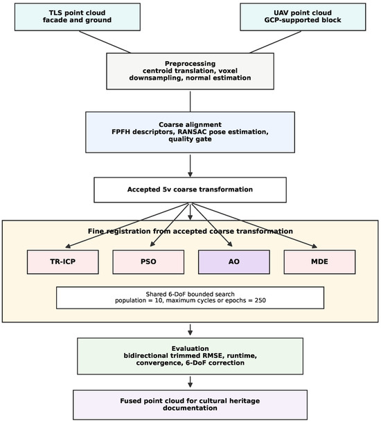
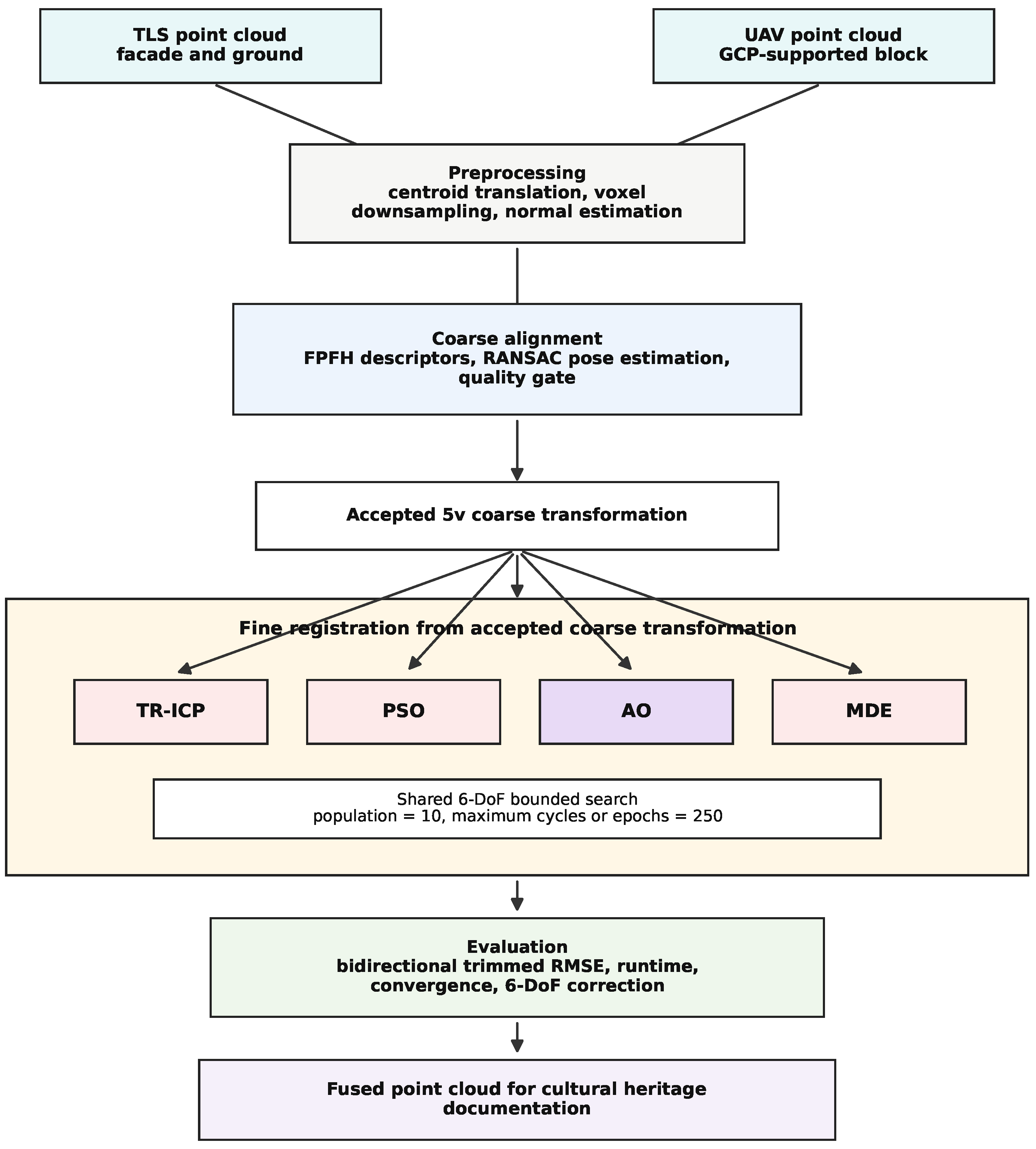
Designed to overcome the limitations of traditional methods, this approach focuses on efficiency and accuracy in handling large-scale datasets. The overall workflow of the proposed approach is summarized in Figure 1. The methodology is detailed sequentially in the following subsections.
Figure 1.
Workflow of the comparative registration approach, including TR-ICP, PSO, AO, MDE, runtime assessment, and 6-DoF correction analysis.
2.1. Study Area: Hasaköy (Sasima) Church
The application site of this study is the Hasaköy Church, also referred to in the literature as the Church of St. Macrina or St. Stephanos, located in the Hasaköy (Sasima) settlement on a volcanic plateau approximately 28 km north of the Niğde city center [38,40,42]. Constructed in the mid-19th century (1848) by the architect Gregor Kalfa using local materials provided by the volcanic masses of Mount Hasan and Mount Melendiz, which shape the geomorphology of Niğde and its surroundings, the structure stands as a significant example of monumental Christian architecture in the region [38,43]. The church functioned as a mosque until the 1970s and is currently out of use [42].
Evaluated as “Type 1G” in typomorphological classifications, the structure features a three-nave basilica plan extending on an east-west axis [37]. Its architectural configuration consists of the main worship space (naos), a seven-section narthex wrapping the western facade in a “U” shape, and a gallery level located above the narthex [40,42]. The primary elements increasing the geometric complexity of the structure include a single-nave burial chapel (parekklesion) built adjacent to the northeast corner and a bell tower located independently to the southeast, the upper section of which has collapsed [40,42].
The primary factor directly affecting the data acquisition process is the material and textural characteristics of the structure. The grey basalt and cut stones used as the main construction materials pose a risk of absorbing laser beams due to their dark color tones and surface roughness [39,42]. Furthermore, the courtyard walls surrounding the structure restrict the setback distance for Terrestrial Laser Scanner (TLS) installation, making it difficult to holistically capture the upper elevations from ground level [40,42].
The superstructure of the building, in particular, represents one of the primary areas where terrestrial methods prove insufficient. The pitched roof covering the barrel and cross vaults is clad in stone slabs specific to the region [39]. Although the freestanding bell tower does not constitute an obstruction for scanning, the fusion of aerial and terrestrial data became mandatory for a holistic 3D modeling of the structure, as the church’s expansive roof surfaces and the upper sections of the adjacent parekklesion cause data voids in ground-based scans [11,12].
2.2. Point Cloud Registration Problem and Preprocessing
The point cloud registration problem is a fundamental geometric optimization problem aimed at transforming two or more three-dimensional point sets into a common coordinate system. Factors such as scan angles, resolution differences, and environmental noise complicate the alignment process, particularly in clouds obtained from different sensor sources.
Technically, given a source point cloud and a target point cloud , the goal is to find the rigid body transformation that best aligns Q onto P. This transformation is expressed by a rotation matrix (special orthogonal group; ) and a translation vector . The general optimization formulation of the problem minimizes the mean distance of the transformed source points to the target point set, as shown in Equation (1) [16]:
where , is a function measuring the distance of the transformed point to its nearest neighbor within the target point cloud P. Since point-to-point correspondences are not known beforehand, is typically calculated using a KD-Tree based nearest neighbor search [44]. This optimization problem is generally non-convex and possesses multiple local minima. Therefore, local methods sensitive to the initial position may fail to find the correct solution in cases of poor initialization.
Preprocessing
To prepare for solving the problem, raw point clouds undergo a series of preprocessing steps. These operations increase computational efficiency by reducing data size and ensure geometric stability in subsequent stages.
(a) Voxel-Based Down-sampling: First, the point cloud is decimated using the voxel down-sampling method. The point cloud space is divided into equal-sized 3D cubic cells (voxels) with edge length v. Points within a voxel indexed by c are represented by the set , and the representative point is determined by the mean position according to Equation (2):
This operation homogenizes point density, suppresses high-frequency noise, and significantly reduces the computational load in large datasets consisting of millions of points.
(b) Estimation of Surface Normals: The second preprocessing step is the estimation of surface normals for each point. These normals are crucial for capturing the local geometric structure and are used particularly in the feature extraction stages. For each point , a neighborhood region with radius r is determined, and the covariance matrix with the points within this neighborhood is defined as shown in Equation (3):
Here, is the mean point of the neighborhood . The normal vector , which is the eigenvector corresponding to the smallest eigenvalue of the matrix calculated via Equation (3), is computed through the minimization problem in Equation (4) [45]:
This approach is based on Principal Component Analysis (PCA) [45] and can be improved using Minimum Spanning Tree (MST) or similar orientation strategies to ensure the directional consistency of the normals. The preprocessing step reduces noise effects while preserving the structural integrity of the point cloud and establishes a reliable geometric basis for the subsequent coarse alignment process [45].
2.3. Coarse Alignment: FPFH and RANSAC
Following the preprocessing steps, the first main alignment stage of the methodology, coarse alignment, is performed. The primary objective of this stage is to estimate a transformation matrix , independent of the initial position, that eliminates large-scale translation and rotation differences between point clouds P and Q. This is a critical step to overcome the local minimum problem resulting from the non-convex nature of the problem defined in Equation (1). Coarse alignment operates based on local geometric features rather than the direct coordinates of point clouds and provides a robust approach against low overlap rates, noise, or scale differences. In this study, a feature-based method is adopted, consisting of two fundamental components: (1) extraction of local geometric features using FPFH [46] and (2) robust transformation estimation via RANSAC (Random Sample Consensus) based on these features [47].
2.3.1. Local Geometric Feature Extraction: FPFH
FPFH is a noise-resistant and computationally efficient local feature descriptor that defines the surface morphology in the neighborhood of each point. The calculation of FPFH relies on an intermediate step called Simplified Point Feature Histogram (SPFH) [46]. For a point , SPFH is a histogram representing geometric relationships within the neighborhood.
SPFH calculates geometric measurements using the Darboux frame () for point and its neighbor : the angular features , , and , together with the Euclidean distance , where , , and [46].
These four measurements are distributed into predefined histogram bins to generate the SPFH of the point. FPFH, on the other hand, combines the SPFH of a point with the weighted SPFHs of its neighbors to encode a broader neighborhood effect and create a richer descriptor (Equation (5)) [46]:
Here, is the set of neighboring points within radius , and is the distance-based weight. The size of FPFH is typically 33 (11 bins for each parameter) and relies on the normals defined in Equations (3) and (4). These features are invariant to rotation and translation, and the computational complexity is (k being the average number of neighbors).
The neighborhood radius was selected relative to the coarse voxel size to reduce sensitivity to the strong density contrast between TLS and UAV data. In the implementation, normals were estimated with a radius of , and the default FPFH radius was also set to , where m is the coarse voxel size. A sensitivity check using , , and is reported in the experiments section. The test indicates that larger support radii can improve the initial RANSAC pose for this cross-source dataset, but the single-scale setting was retained as a conservative default to avoid excessive smoothing of local facade geometry. Multi-scale aggregation is therefore discussed as a promising extension rather than assumed in the present workflow.
The final TR-ICP, PSO, AO, and MDE comparison is based on the accepted coarse transformation. The result is reported only as a coarse-alignment sensitivity check. Because a different FPFH support radius changes the RANSAC initialization, it could also change downstream fine-registration values; therefore, no fine-registration ranking is inferred from the sensitivity result.
2.3.2. Feature-Based Matching and Robust Transformation Estimation with RANSAC
After extracting the FPFH feature sets and , the nearest matching point in the target for the source point is determined by a Nearest Neighbor search in the feature space according to Equation (6) [46]:
This forms the set of potential correspondences . However, due to repetitive geometries or noise, most of these correspondences are incorrect. RANSAC is a probabilistic method used to estimate the best rigid body transformation from datasets with high outliers. The algorithm follows these steps [47]:
(1) Sampling: correspondences are randomly selected from the set .
(2) Transformation Calculation: A transformation is calculated for these k correspondences using the least-squares method (Equation (7)) [47,48]:
(3) Verification (Inlier Detection): The transformation is applied to the entire set , and the set of “inlier” (consistent) correspondences that are closer than a threshold (a distance threshold) is found according to Equation (8) [47]:
(4) Selection: When a certain maximum number of iterations or a confidence probability p is reached, the transformation with the highest number of inliers is selected as the best coarse alignment according to Equation (9) [47]:
For additional robustness, the RANSAC process is typically integrated with additional geometric validators. For example, an ‘edge length check’ (ensuring the distances between the randomly selected k samples are consistent with the distances in their potential matches, e.g., 90%) or a ‘distance check’ (inlier threshold ) can be used. These checks increase the resilience of the transformation against distorted geometries.
2.3.3. Result: Coarse Transformation Matrix
At the end of the RANSAC process, the coarse alignment transformation is obtained as a matrix in homogeneous coordinates as shown in Equation (10) [47]:
This matrix initializes the global optimization in Equation (1) with an approximate solution and provides a critical starting position for the subsequent fine-tuning step.
2.4. Fine-Tuning
The transformation obtained as a result of the coarse alignment stage approximates the point clouds globally; however, full alignment is not achieved due to remaining deviations on a local scale. The fine-tuning stage is designed to locally refine the optimization problem in Equation (1) to minimize these deviations.
Here, represent the translation components, and represent the rotation components as Euler angles. To reduce the risk of traditional methods getting stuck in local minima, this study adopts an MDE-based metaheuristic optimization strategy and compares its fine-registration performance with the TR-ICP algorithm, PSO, and AO, which serve as deterministic, classic population-based, and recent population-based baselines, respectively. MDE is designed to exhibit robust performance in noisy and multimodal optimization problems by combining the global search capability of evolutionary algorithms with “partial-elitist” mutation and parameter-free crossover mechanisms.
2.4.1. Initial Alignment Evaluation and Adaptive Search Boundaries
Before fine-tuning begins, the quality of the coarse alignment is evaluated. The RMSE between the source cloud transformed by and the target cloud P is calculated by Equation (12):
Here, is the nearest neighbor distance. This metric dynamically determines the boundaries ( and ) of the parameter vector x within which the MDE algorithm will search. Based on the RMSE value, the translation range and rotation range are adjusted dynamically. Specifically, if the initial alignment is accurate (e.g., RMSE < 1.0 m), the search space is narrowed to prioritize fine-tuning (exploitation); conversely, for larger errors, the bounds are expanded to increase the probability of escaping local minima. The 6-DoF decomposition showed that the accepted coarse transformations may still require a residual rotation of approximately around the vertical axis. Therefore, the stochastic fine-registration stage uses a minimum rotation boundary of for PSO, AO, and MDE, even when the initial one-way RMSE is below 1.0 m. This adaptation accelerates convergence by making the search space efficient while preventing an excessively narrow rotational search in cross-source TLS-UAV data.
In this study, for all error values reported and the coarse alignment analysis, bidirectional trimmed RMSE was used instead of the classic one-way RMSE. Accordingly, nearest point distances are calculated in both source-to-target and target-to-source directions; after merging these two sets, the worst (largest) 10% are discarded as outliers, and the square root of the mean of the squares of the remaining distances is taken. Thus, alignment accuracy is evaluated in a more symmetric and robust manner, especially in point clouds containing partial overlaps and outliers. Equation (12), on the other hand, represents the one-way RMSE used solely for determining the adaptive search boundaries.
2.4.2. Trimmed Iterative Closest Point (TR-ICP)
ICP [16] is adopted as the standard fine-tuning method in the literature. Standard ICP is a local optimizer that takes the coarse transformation as a starting point and aims to minimize the squared error between the source point set Q and the target point set P. The objective function of standard ICP is defined over all point pairs as shown in Equation (13) [16]:
Here, represents the transformed source point, and represents the nearest neighbor within the target set P (). However, since standard ICP includes all correspondences in the optimization, it has a high risk of getting trapped in local minima in cases of partial overlap and outliers.
In this study, the TR-ICP variant [49] was used to overcome these limitations in the standard method. TR-ICP follows these steps in the iterative process:
(1) Matching and Filtering: Nearest neighbors are found in each iteration, and correspondences exceeding a certain distance threshold () () are directly eliminated.
(2) Trimming: The remaining correspondences are sorted by error magnitude, and only the “inlier” set with the lowest error ratio (in this study ) is selected.
(3) Minimization: Transformation parameters are updated to minimize the modified objective function in Equation (14) solely over this reliable set:
This minimization problem is solved analytically using Singular Value Decomposition (SVD) over the weighted covariance matrix H of the points in set (). This approach provides a much more stable convergence compared to standard ICP in noisy data and retains the trimmed-correspondence principle of the original TR-ICP formulation [49].
2.4.3. Particle Swarm Optimization (PSO)
Particle Swarm Optimization (PSO) was implemented as a population-based metaheuristic baseline for the fine-registration evaluation. PSO updates candidate transformations through inertial, cognitive, and social velocity components following Kennedy and Eberhart [27]. The symbols below follow the widely used source notation: the d-th component of particle i is updated from its position , velocity , personal best position , and global best position . Here, w is the inertia weight, and are the cognitive and social acceleration constants, and and are random numbers in :
PSO was run on the same 6-DoF vector in Equation (11), used the same adaptive translation and rotation boundaries as MDE, and minimized the same trimmed nearest-neighbor fitness function defined in Equation (17). The PSO swarm size and the MDE selected sub-population size were set to 10, and the maximum number of iterations or cycles was set to 250. PSO used an inertia coefficient of 0.7298, with cognitive and social coefficients of 1.49618. The same accepted coarse transformation was used for TR-ICP, PSO, AO, and MDE in the common-start evaluation to ensure that differences in the fine-tuning stage were not caused by different RANSAC initializations. These PSO update equations and parameters follow the canonical formulation of Kennedy and Eberhart [27].
2.4.4. Aquila Optimizer (AO)
Aquila Optimizer (AO) is a contemporary population-based metaheuristic introduced by Abualigah et al. [28]. It alternates between expanded exploration, narrowed exploration, expanded exploitation, and narrowed exploitation mechanisms that model the hunting behavior of Aquila. In the source notation of AO, denotes the current candidate position, is the best position at iteration t, is the population mean, is a randomly selected candidate, T is the maximum number of iterations, and are the lower and upper bounds, and is the Levy flight vector in dimension D.
Here, r is a random number in , x and y control the spiral movement in the narrowed exploration stage, and are exploitation adjustment constants, and , , and are AO quality and control functions as defined in the original formulation [28]. In this study, AO was applied to the same 6-DoF vector, adaptive bounds, accepted coarse transformation, population parameter of 10, maximum epoch budget of 250, and early-stopping patience of 30 used for the stochastic fine-registration comparison. This implementation follows the original AO formulation and notation of Abualigah et al. [28].
2.4.5. Multi-Population Based Differential Evolution (MDE)
To overcome the local minimum limitation of ICP, an MDE-based, stochastic, and population-based optimization approach is proposed in this study based on Karkinli’s multi-population based differential evolution formulation [31]. MDE searches within the 6-DoF parameter space defined in Equation (11) and offers two fundamental innovations:
(a) Accelerated & Robust Fitness Function: The objective function to be optimized by MDE is designed for computational efficiency and robustness against outliers. In each fitness evaluation, a random subsample () is used instead of the entire source cloud. The nearest neighbor distances of the transformed sample points to the target cloud are calculated, sorted, and a certain ratio of the worst (furthest) values are discarded as outliers. Fitness is calculated as the Mean Squared Error (MSE) of the remaining inlier points as shown in Equation (17):
Here, x denotes the 6-DoF candidate transformation vector, is the random source subsample size, is the discarded outlier ratio, and are the sorted nearest-neighbor distances retained after transformation. This approach ensures that the alignment process is less affected by partial overlap and noise. This trimmed distance-based objective function used in the MDE and PSO and AO searches is structured to be consistent with the trimming strategy used in the TR-ICP method; thus ensuring a fair comparison by evaluating TR-ICP, PSO, AO, and MDE over similar overlapping regions. While this fitness function optimized by the stochastic methods is defined on a random subsample, the final RMSE values reported throughout the study were calculated using the bidirectional trimmed RMSE metric over the entire fine-scale point clouds.
(b) MDE Optimization Process [31]: The algorithm initializes a population (A) of size within adaptive boundaries. In each iteration, a random sub-population (B) is selected from the main population, and evolutionary operators are applied. The symbols A, B, T, , , and are kept in the notation used by Karkinli’s original MDE formulation [31]. The fundamental equation of MDE is as given in Equation (18):
Here, T represents the trial vectors, B is the selected sub-population, is the mutation-derived temporary population, is the binary crossover map, is the diversity component, and ⊙ denotes element-wise multiplication. This equation combines the core components of MDE [31]:
(1) Mutation (): MDE uses a “partial-elitist” mutation strategy. This strategy generates the vector by combining differential vectors (difference of random individuals), the best individual (), and a dynamic, “power-law” based scale factor (F).
(2) Crossover (): Unlike the CR parameter of standard DE, MDE uses a parameter-free and probabilistic binary map matrix that determines which parameters are passed to the trial vector.
(3) Noise: A component is introduced to preserve population diversity and avoid premature convergence.
At the end of each iteration, if , meaning the trial vector provides a better fitness, it replaces the current individual in the population. If no improvement is observed in the fitness value for a certain iteration count, the algorithm performs “early stopping” and returns the best solution (). The optimization operators and stopping notation follow the original MDE formulation [31].
2.4.6. Final Transformation Integration
Once the fine-tuning stage is completed, a fine-tuning matrix is generated from the best parameters. The final transformation is obtained as the composition of the coarse alignment and fine-tuning matrices as shown in Equation (19):
3. Experiments
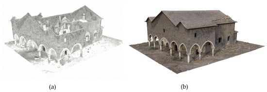
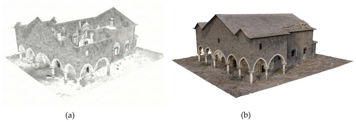
In this section, the performance of the proposed registration pipeline is evaluated based on the accuracy of input data, coarse alignment success, and comparative results in the fine-tuning stage (TR-ICP, PSO, AO, and MDE). The datasets used to evaluate the performance of the proposed method have different sensor characteristics and geometric coverage areas. A visual comparison of the datasets is presented in Figure 2.
Figure 2.
Point clouds used in the study: (a) TLS data containing only facade and ground details, (b) Reference UAV data containing roof and surrounding details.
3.1. Dataset Characteristics
3.1.1. Terrestrial Laser Scanning (TLS) Data
In this study, the TLS point cloud was used as the source dataset to be transformed into the reference coordinate system. The data was obtained by scanning the building facade from 16 different stations using a FARO Focus3D X 330 (FARO Technologies Inc., Lake Mary, FL, USA) TLS. The scanning resolution (step interval) of the laser scanner is the minimum 0.009° (40,960 points in a 360° scan) capable of being provided by the device horizontally and vertically. This high-density sampling capability is particularly effective in minimizing reflection losses on the grey basalt stone surfaces of the structure [9,39].
Raw scan data were merged using cloud-to-cloud and target-based registration methods using FARO SCENE 2019.0 (FARO Technologies Inc., Lake Mary, FL, USA). As a result of the registration process, the mean point error between stations was calculated as 2.0 mm, and the maximum point error as 3.2 mm (minimum overlap 10.6%). This obtained millimeter-level internal accuracy indicates that the merged TLS data preserves its geometric integrity and constitutes a high-quality source dataset for subsequent alignment stages. As an important point; due to scans being performed from ground level, the TLS data contains only the building facades and the ground surface, and does not harbor data regarding the building roof. This situation creates a “partial overlap” challenge in alignment performed with the reference UAV data which also includes the roof.
3.1.2. UAV Photogrammetric Point Cloud Data
In the alignment process, the dense point cloud generated with a DJI Phantom 4 RTK multicopter and integrated DJI FC6310R camera system (SZ DJI Technology Co., Ltd., Shenzhen, China) was used as the target (reference) dataset. A total of 707 images were collected with the camera having 5472 × 3648 pixel resolution (20 MP, 1-inch CMOS sensor) from an average flight altitude of 25 m over the study area, yielding a Ground Sampling Distance (GSD) of 6.2 mm, using oblique angles specifically to capture building facade details completely.
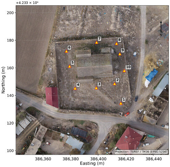
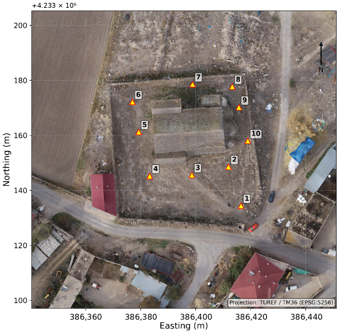
During the flight operation, the aerial vehicle was operated connected to the TUSAGA-Aktif (CORS) network, thus the exterior orientation parameters (coordinates and rotation angles) of the images were recorded directly with centimeter precision. In order to audit the absolute accuracy of the photogrammetric block adjustment and optimize georeferencing, 10 Ground Control Points (GCPs) were established with homogeneous distribution in the project area, and their coordinates were determined via terrestrial GNSS measurements using a CHC i80 GNSS receiver (Shanghai Huace Navigation Technology Ltd., Shanghai, China).
The spatial distribution of these ground control points is illustrated in Figure 3. The residual error amounts obtained at the GCPs as a result of block adjustment are summarized in Table 1.
Figure 3.
Spatial distribution of the 10 Ground Control Points (GCPs) established in the study area for georeferencing and accuracy assessment (Coordinate System: TUREF/TM36-EPSG: 5256).
Table 1.
GCP error values after UAV photogrammetric block adjustment.
Upon examining the data in Table 1, it is observed that the total positional error (RMSE) of the reference dataset is 1.34 cm, and the average reprojection error on the image plane is 0.462 pixels. These high accuracy values demonstrate that the UAV point cloud reliably represents the reference coordinate system to which the TLS data will be aligned. Furthermore, unlike the TLS data, the UAV data holistically includes the building roof and its surroundings, creating a difference in geometric coverage between the two datasets.
3.2. Coarse Alignment Results
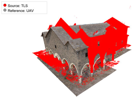
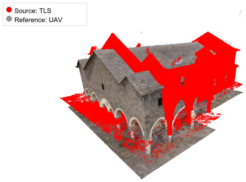
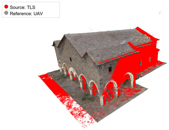
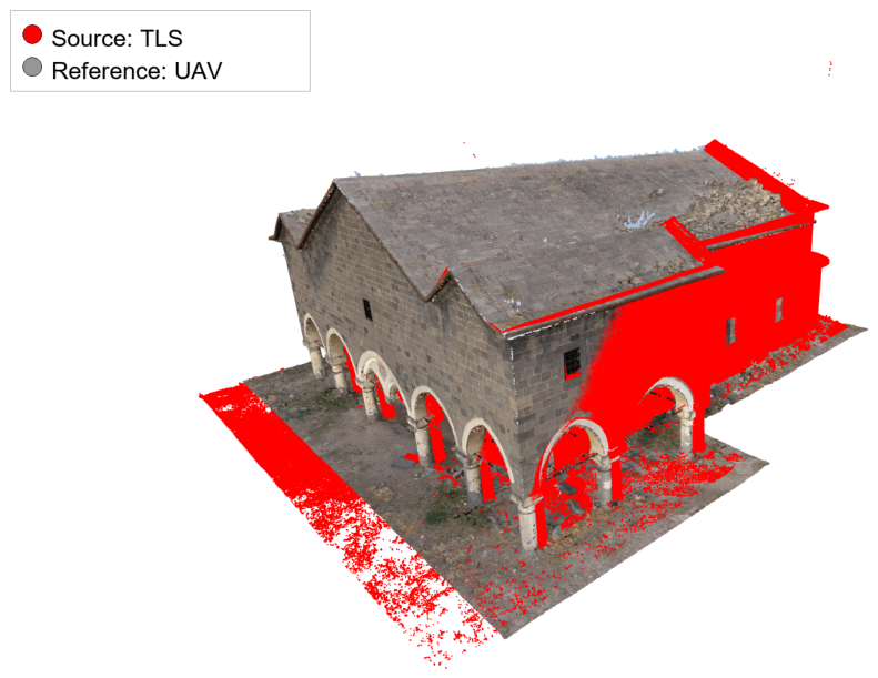
The first stage of the proposed alignment approach aims to eliminate large-scale transformation differences between the source TLS data in the local coordinate system and the reference UAV data in the global coordinate system. Both point clouds were first translated relative to their centroids to establish an initial position. Subsequently, FPFH attributes representing the geometric properties of the point clouds were extracted, and the coarse transformation matrix () was estimated using the RANSAC algorithm. Alignment performance was quantitatively analyzed based on average error values obtained from 30 repeated experiments. When the point clouds were translated solely based on their centroids in the initial stage, the average RMSE value was calculated as 1.75 m due to significant orientation (rotation) differences between the datasets, and this condition is visualized in Figure 4. Through the subsequently applied FPFH-based RANSAC process, the TLS data was coarsely aligned to the UAV data; as a result, the average bidirectional trimmed RMSE was reduced to 0.5668 m for the accepted setting. The visual result obtained after coarse alignment is presented in Figure 5.
Figure 4.
Initial position: Reference UAV (RGB) and source TLS (red) point clouds translated relative to centroids.
Figure 5.
Coarse alignment result after FPFH + RANSAC. Source TLS data (red), reference UAV (RGB) data. Visible residual differences also reflect partial overlap and sensor-specific coverage.
Upon examining Figure 5, the RANSAC result provides a usable global facade match, while visible differences remain in areas with incomplete overlap, different viewing geometry, or sensor-specific point density. Coarse alignment reduced the bidirectional trimmed RMSE from 1.75 m to 0.5668 m for the accepted setting, providing a suitable initial position that minimizes the risk of local minima for fine-tuning algorithms. Additionally, the quality of the coarse transformation obtained via RANSAC was evaluated in terms of bidirectional trimmed RMSE against the configuration obtained initially through centroid translation only; in cases where the RANSAC result produced a higher error than the initial state, the coarse transformation matrix was reverted to the identity transformation before proceeding to the fine-tuning stage. Thus, the propagation of erroneous global matchings to the TR-ICP, PSO, AO, and MDE stages was prevented.
To evaluate the sensitivity of the single-scale FPFH support radius, additional coarse-alignment tests were performed using neighborhood radii of , , and , where m is the coarse voxel size. The same RANSAC settings were retained for all tests. Table 2 shows that the larger radius provided the lowest coarse RMSE in this dataset, while remained a balanced default that preserves more local facade detail. This result confirms that FPFH scale is relevant for cross-source TLS-UAV registration and motivates future multi-scale aggregation.
Table 2.
Sensitivity of the FPFH neighborhood radius in the coarse alignment stage.
The fine-registration statistics reported below use the accepted coarse transformation, not the lower coarse-RMSE sensitivity pose. The setting was not substituted into the final comparison because doing so would define a different coarse-to-fine workflow rather than a controlled fine-stage comparison from the same starting transformation.
3.3. Fine-Tuning Evaluation of TR-ICP, PSO, AO, and MDE
The transformation matrix obtained in the coarse alignment stage, which reduced the bidirectional trimmed RMSE to 0.5668 m under the accepted setting, was provided as a common starting point for the fine-tuning stage. At this stage, the performances of TR-ICP, PSO, AO, and MDE were summarized over a set of 30 runs. For evaluation, the trim ratio was set to 90% and the maximum number of iterations to 50 for the TR-ICP method; whereas for PSO, AO, and MDE, a population parameter of 10, a maximum of 250 iterations or cycles, and an early stopping criterion after 30 successive iterations or cycles without improvement were applied.
Summary statistics for the RMSE values obtained from the experiments are presented in Table 3.
Table 3.
RMSE (m) statistics of fine alignment methods (30 runs). PSO, AO, and MDE used the same accepted coarse transformation and common stochastic search settings.
For the fine-tuning evaluation in Table 3, TR-ICP, PSO, AO, and MDE used the same accepted RANSAC transformation as initialization. PSO, AO, and MDE used the same 6-DoF vector, adaptive translation and rotation bounds, population parameter of 10, maximum budget of 250 iterations or cycles, and early stopping criterion after 30 successive iterations or cycles without improvement. MDE refers here to Karkinli’s multi-population based differential evolution algorithm [31]; denotes the selected sub-population size used by that formulation, while the main MDE population retains the three-sub-population structure defined in the algorithm.
The computational tests were run on a Windows 11 (Microsoft Corporation, Redmond, WA, USA) workstation with an Intel64 processor family, 16 logical CPU cores, and 15.67 GB of RAM using Python 3.12.13, Open3D 0.19.0, NumPy 2.3.5, and SciPy 1.17.1. AO was implemented with MEALPY 3.0.3 using the OriginalAO implementation. After fine voxelization, the TLS source cloud contained 648,388 points and the UAV target cloud contained 1,108,035 points; the coarse FPFH stage used 2401 TLS points and 2996 UAV points.
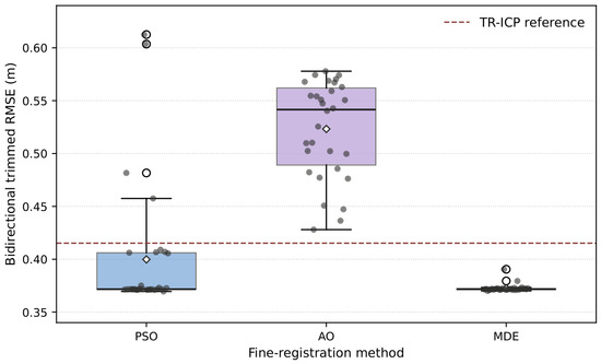
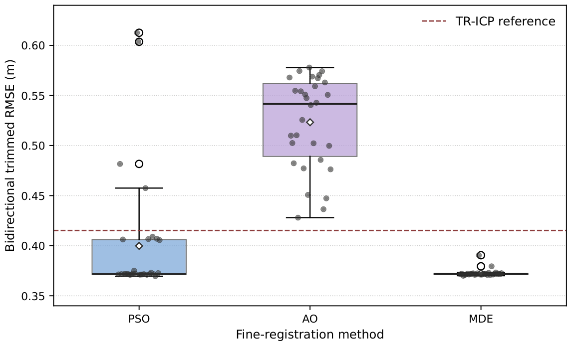
Table 3 reports one 30-run RMSE row for each fine-tuning method. Under the same accepted coarse transformation, PSO reached low-error runs but displayed a broader stochastic tail, whereas the MDE median remained 0.3718 m under the same population and cycle budget. AO remained farther from the low-error regime, with a mean RMSE of 0.5233 m and a median RMSE of 0.5416 m. Table 4 reports the corresponding runtime and convergence-cost statistics.
Table 4.
Runtime and convergence-cost statistics under common fine-stage settings.
The 6-DoF correction analysis in Table 5 further shows that the remaining refinement is not purely translational. The TR-ICP and MDE corrections under the common fine-stage settings concentrate near a translation norm of 0.71 m and a rotation angle of 3.4°, while PSO exhibits broader deviations under the same reduced population setting. AO follows the same 6-DoF search protocol and shows a smaller mean correction norm but a higher final RMSE, indicating that its early convergence did not reach the low-error alignment basin in this dataset. The dominant angular component appears around the z-axis. This decomposition supports the minimum rotational search boundary used after coarse alignment.
Table 5.
Six-DoF decomposition of the fine-registration correction relative to the accepted coarse transformation. AO is summarized from the same 30-run protocol.
For physical interpretation, it is important to distinguish the reported bidirectional trimmed RMSE from local registration precision in the overlapping facade region. The former still contains the effect of different sensor coverage, especially UAV roof and ground areas without TLS counterparts. When the same final transformations are evaluated with the one-way trimmed overlap objective on the TLS source points, the residuals are approximately 2.4 cm for TR-ICP and 2.4–2.8 cm for the best stochastic solutions. Therefore, the 0.37 m aggregate value should not be read as the dimensional accuracy of facade details, but as a conservative cloud-to-cloud distance metric for a severely partial-overlap fusion problem.
As shown in Figure 6, PSO and MDE form stochastic distributions around the common-start fine-registration error floor. The AO distribution is farther from the TR-ICP reference and the low-error MDE cluster under the same bounded search setting. Table 3 refines this interpretation. When PSO and MDE start from the same accepted coarse transformation and use a rotational search range wide enough to include the 6-DoF correction, the MDE median remains in the low-error regime, whereas PSO is more sensitive to the reduced population budget. AO provides a recent population-based baseline for method comparison and confirms that the observed MDE behavior is not explained only by comparison with classic PSO. Therefore, the performance claim is not that MDE is universally superior in mean RMSE, but that it is a competitive, training-free global optimizer while retaining a parameter-light structure.
Figure 6.
Distribution of bidirectional trimmed RMSE values for PSO, AO, and MDE under common fine-stage settings. The dashed line indicates the deterministic TR-ICP reference.
The MDE RMSE distribution was also evaluated relative to the deterministic TR-ICP reference in Table 3. The MDE differences from the TR-ICP RMSE did not follow a normal distribution according to the Shapiro–Wilk test (). A one-sample Wilcoxon Signed-Rank Test on these differences showed that the MDE RMSE values remained significantly below the TR-ICP reference (). This statistical result is interpreted together with the PSO and AO distributions in the same fine-tuning evaluation so that the algorithmic interpretation remains transparent and not based on one stochastic baseline.
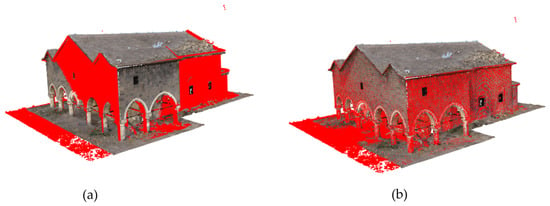
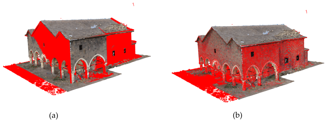
The alignment quality of the methods was evaluated through both holistic model appearance and cross-section analysis. In Figure 7, the general alignment results of TR-ICP and MDE methods are presented side by side. These visual comparisons should be read as qualitative evidence from partially overlapping TLS and UAV datasets, not as a complete separation between registration error and sensor-coverage effects.
Figure 7.
Comparison of alignment results: (a) TR-ICP and (b) MDE. Residual visible differences can also arise from partial overlap, different point densities, and sensor-specific coverage.
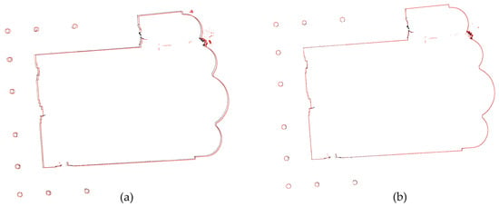
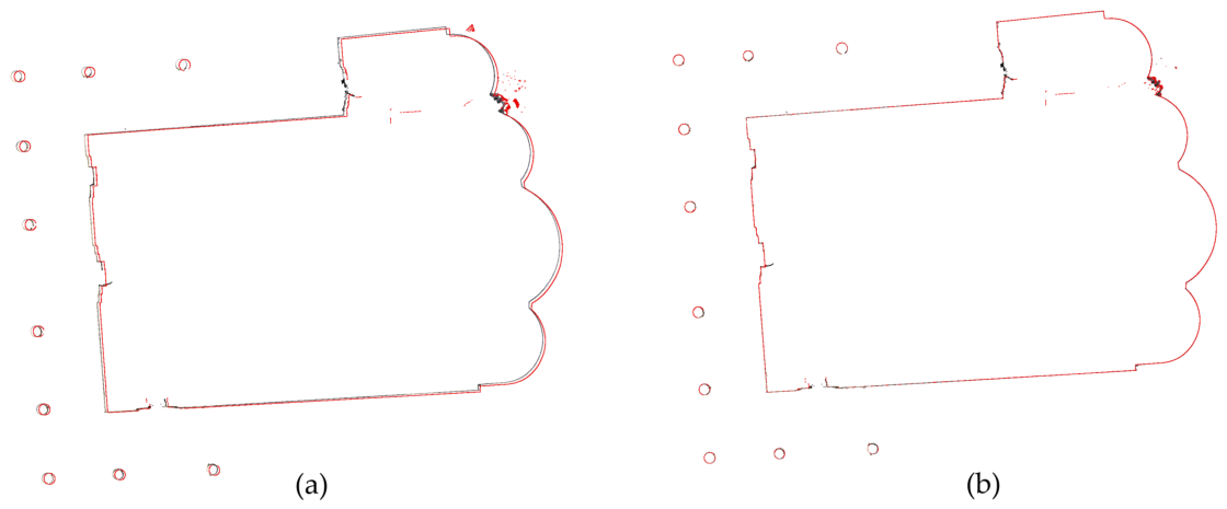
To examine this difference in local cross-sectional alignment, horizontal cross-sections taken from the building facade are compared in Figure 8. When the TR-ICP section in Figure 8a is examined, a systematic gap or shift is visible between the grey (reference) and red (source) wall surfaces in the overlapping facade portion. This pattern indicates that TR-ICP converged to a local minimum and terminated before the facade planes were fully aligned. However, not every residual difference in the cross-section should be attributed to registration failure, because coverage gaps and density differences also affect the visual comparison. In contrast, in the MDE section in Figure 8b, the overlapping wall surfaces show closer coincidence rather than a complete absence of residual difference. The MDE solution reduced this gap through population-based exploration of the fine-registration search space and produced a more consistent facade-plane alignment.
Figure 8.
Horizontal cross-section analysis: (a) Section obtained with TR-ICP, (b) Section obtained with MDE. The comparison emphasizes overlapping facade geometry; residual differences may also reflect partial overlap and sensor-specific sampling. In each section, the reference UAV cross-section is shown in grey and the registered TLS source in red.
Runtime and Convergence-Cost Analysis
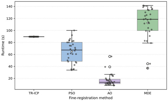
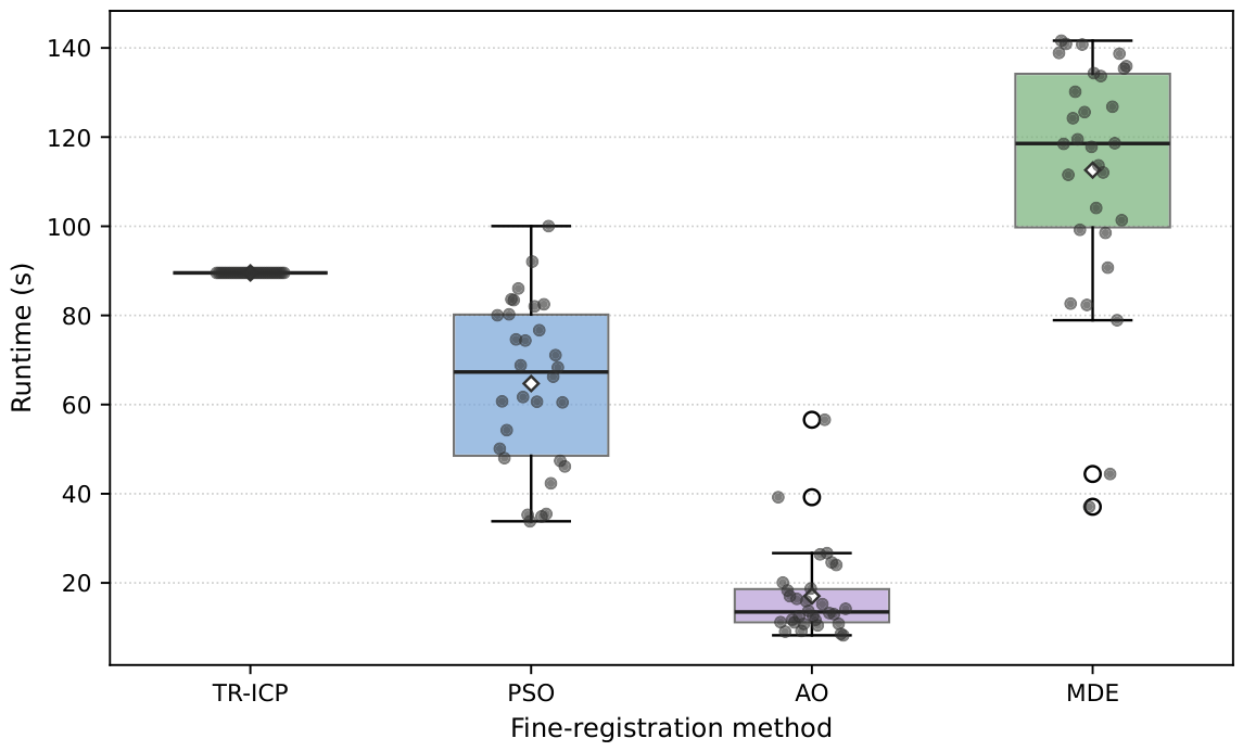
The optimization behavior of the methods was also examined through runtime and the number of iterations or cycles required by each method. Figure 9 summarizes the runtime distributions for TR-ICP, PSO, AO, and MDE.
Figure 9.
Runtime distributions for TR-ICP, PSO, AO, and MDE under common fine-stage settings. AO uses the same population and maximum epoch budget.
In Figure 9, the stochastic optimizers occupy different runtime regions. PSO is faster on average under the reduced population setting, AO terminates earlier on average but at a higher RMSE, whereas MDE spends more cycles in adaptive population-based fine search. TR-ICP provides the deterministic runtime reference under the same accepted coarse transformation. The runtime results in Table 4 show the expected cost trade-off among local deterministic refinement and population-based search. The MDE method therefore has a higher computational cost than deterministic fine-tuning, but it remains useful when a training-free global search is preferred for partially overlapping and heterogeneous heritage point clouds.
4. Discussion
The digital documentation of complex cultural heritage sites demands methodologies that can overcome the limitations of individual sensors while ensuring geometric consistency. This study addressed the challenge of fusing TLS and UAV photogrammetry data for the 3D reconstruction of the Hasaköy (Sasima) Church. The proposed Multi-population Based Differential Evolution (MDE) algorithm for point cloud registration demonstrates a practical route for automating the alignment of disparate datasets, a critical step in heritage preservation workflows.
4.1. Evaluation of Multi-Sensor Data Fusion
The morphological complexity of the Hasaköy Church, characterized by its “Type 1G” basilica plan, varying wall thicknesses, and expansive stone-clad roof, necessitated a multi-sensor approach. The findings confirm that relying solely on TLS results in significant data voids, particularly on the roof and upper structural zones inaccessible from the ground. This aligns with the observations of Handl [11], who noted that TLS captures vertical surfaces effectively but misses roofs, whereas UAVs excel at horizontal coverage but often lack the terrestrial detail required for complex facades.
The integration of UAV photogrammetry filled these voids and enabled a holistic model. This complementary relationship mirrors the findings of Alshawabkeh, Baik and Miky [9] and Li, Peng, Tang and Li [12], who demonstrated that fusion-based workflows significantly reduce data shadows and improve model completeness for complex structures. Furthermore, the statistical analysis of the UAV dataset revealed a total positional RMSE of 1.34 cm, validating its reliability as a reference system for aligning the terrestrial data.
The GCP error values should be interpreted separately from the TLS-UAV point cloud registration error. The GCP statistics quantify the absolute georeferencing quality of the UAV photogrammetric block after block adjustment, whereas the registration RMSE evaluates the cloud-to-cloud distance between two independent sensing products with different density, noise, and geometric coverage. Therefore, the centimeter-level GCP RMSE does not mean that the TLS-UAV registration should also be centimeter-level over the entire bidirectional cloud distance, especially because the UAV dataset includes roof and ground surfaces that have no TLS counterpart.
4.2. Performance of MDE Registration
The core contribution of this study is the application of the MDE algorithm to the point cloud registration problem. The fine-tuning evaluation of TR-ICP, PSO, AO, and MDE shows that MDE reaches the low-error registration regime while retaining an adaptive, parameter-light multi-population search. Under the common accepted coarse transformation and population parameter of 10, MDE produced a median bidirectional trimmed RMSE of 0.3718 m in this evaluation. The result positions MDE as a robust global-search alternative rather than as a universally faster or unconditionally more accurate method. As visualized in the horizontal cross-section analysis (Figure 8), the MDE solution improves the geometric congruency of the facade sections relative to the problematic local alignment case.
This finding addresses a pervasive limitation of the ICP algorithm reported extensively in the literature: its susceptibility to local minima when initial positions are not strictly aligned. While previous studies have attempted to mitigate this by hybridizing ICP with global optimizers, the results suggest that MDE offers a useful balance between robustness and implementation simplicity. The “parameter-free” structure and “power-law-based scale-invariant” strategy of MDE reduce the need for manual mutation and crossover tuning, as also highlighted by Karkinli [31]. This is further supported by the comparative study of Hüsrevoğlu, Janowski and Karkınlı [32], which found MDE to perform strongly against PSO, ABC, and GWO in complex spatial optimization tasks regarding both speed and robustness.
4.3. Comparison with State-of-the-Art Registration Methods
The performance of MDE in this study can be contextualized by comparing it with other recent metaheuristic approaches. For instance, Barrios, Guzman, Adams and Rudorfer [18] evaluated Artificial Rabbits Optimization (ARO) to overcome the computational complexity and local minima issues of PSO-based methods. Similarly, Ren, Zhao and Han [24] utilized chaotic maps to improve population diversity. While these methods show promise, the MDE approach utilized here distinguishes itself through its multi-population structure, which naturally facilitates parallel processing and diversity maintenance without the need for auxiliary chaotic maps or complex mutation operators.
The PSO and AO experiments provide modern metaheuristic baselines within the same Hasaköy Church dataset.
AO represents a recent population-based optimizer evaluated under the same accepted coarse transformation, 6-DoF search vector, population parameter, and maximum epoch budget. AO reached a mean bidirectional trimmed RMSE of 0.5233 m, which remained above the corresponding PSO and MDE values in this dataset. The common-start values show that the reduced population budget affects PSO and MDE search behavior differently. Together, the PSO and AO comparisons position MDE as a stable, parameter-light optimizer for this partially overlapping cultural-heritage case rather than as a universally dominant optimizer. The practical distinction is therefore better expressed through robustness, runtime, and parameterization rather than through a large mean RMSE gap.
Compared with learning-based registration approaches, the proposed workflow does not require a pre-trained model or site-specific training pairs. This is important for one-off endangered monuments, where conservation workflows often prioritize reproducibility, traceable parameters, and direct inspection of geometric corrections over learned generalization.
Furthermore, the coarse-to-fine strategy, employing FPFH and RANSAC for initial alignment followed by population-based refinement, proved effective. This hierarchical approach is supported by Tian, Yue and Zhu [6] and Shi, Liu and Han [25], who emphasize that providing a reliable initial pose is crucial for the success of fine registration algorithms. However, unlike standard workflows that rely solely on ICP for the final step, the comparative analysis demonstrates that stochastic optimizers can be evaluated as transparent alternatives for the final step. The runtime analysis (Figure 9) further illustrates this behavior: the stochastic optimizers occupy different runtime regions, TR-ICP converges to a stable deterministic solution, and MDE continues a population-based search with a parameter-light formulation. AO converged faster on average but did not achieve the same fine-registration RMSE level, illustrating the accuracy-runtime trade-off among contemporary metaheuristic alternatives.
4.4. Implications for Cultural Heritage Preservation
The faithful 3D reconstruction of the Hasaköy Church has significant implications for its preservation. As noted by Adamopoulos and Rinaudo [1], the integration of multi-source data is essential for understanding the preservation state of monuments facing environmental and structural threats. The specific architectural details documented in this study, such as the U-shaped narthex and the unique basalt stone texture, provide a permanent digital record that can support future restoration efforts.
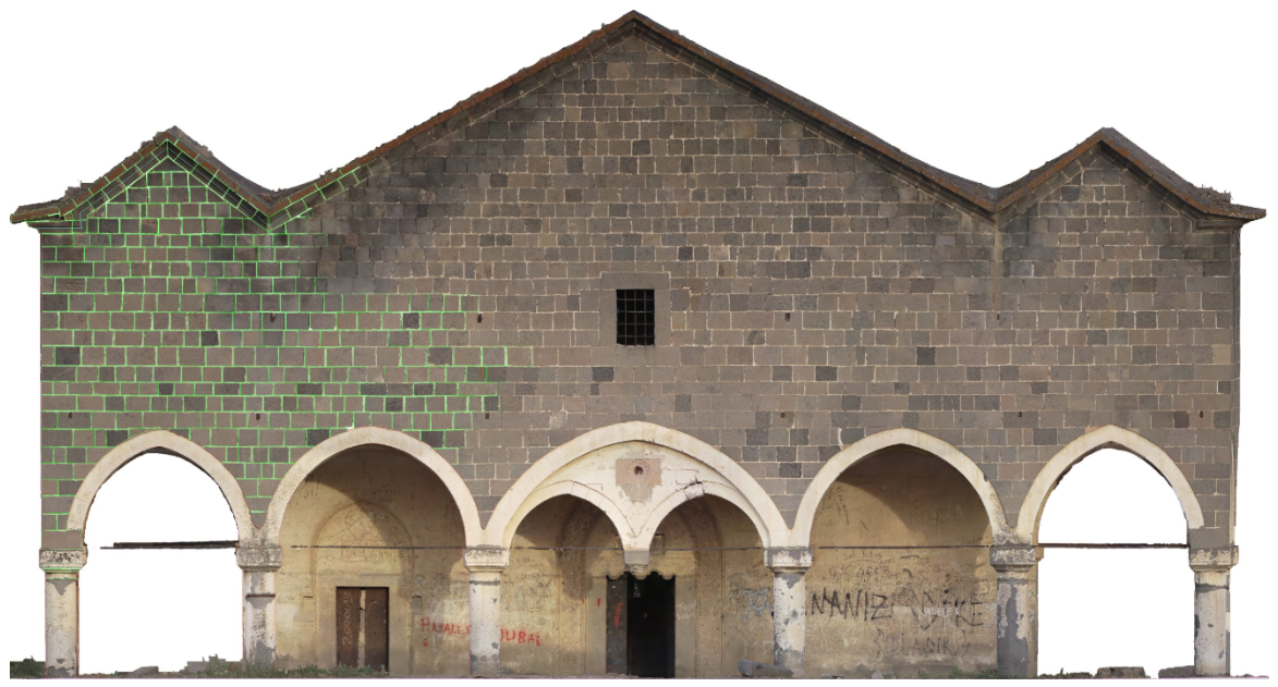
Furthermore, the geometrically consistent fused point cloud serves as a direct base for creating precise 2D architectural drawings (restitution), enabling the detailed vectorization of complex masonry patterns as demonstrated in Figure 10.
Figure 10.
Application of the fused point cloud for architectural documentation: 2D vectorization (röleve) of the basalt stone masonry facade, demonstrating the utility of the proposed method for detailed heritage recording.
Moreover, as the field moves towards “digital twins” and comprehensive Heritage BIM (HBIM), the ability to accurately and automatically register data from diverse sensors without manual intervention will become increasingly critical. The proposed methodology offers a robust solution to the alignment error propagation often cited as a barrier to effective multi-sensor fusion.
4.5. Limitations and Future Work
While the MDE algorithm demonstrated competitive accuracy in the fine-tuning evaluation, it incurred a higher average computational cost than PSO and AO and a similar or higher cost than the deterministic TR-ICP run in this implementation. The FPFH-radius test also shows that the single-scale descriptor support affects the RANSAC pose; therefore, a multi-scale FPFH strategy should be evaluated in future work. This trade-off between runtime, search-space coverage, and global optimality is a common characteristic of evolutionary algorithms. Future research could explore GPU parallelization of MDE, multi-scale feature aggregation, and semantic segmentation prior to registration so that alignment is driven by structurally significant masonry and facade features rather than vegetation, roof-only surfaces, or other non-overlapping elements.
5. Conclusions
This study presented a comprehensive workflow for the robust 3D documentation of complex cultural heritage sites, demonstrating the efficacy of fusing TLS and UAV photogrammetry. The application of this methodology to the Hasaköy (Sasima) Church addressed the significant challenges posed by its “Type 1G” architectural typology, specifically the occlusion of the expansive stone roof from ground-based sensors and the lack of facade detail in aerial views. The integration of these complementary datasets achieved a holistic digital reconstruction that preserves the geometric integrity of the structure’s unique basalt masonry and volumetric configuration.
The primary contribution of this research is the novel application of the Multi-population Based Differential Evolution (MDE) algorithm to the point cloud registration problem in a cultural heritage context. The fine-tuning evaluation of TR-ICP, PSO, AO, and MDE confirmed that MDE can recover a low-error alignment after coarse registration while using its adaptive multi-population search structure. Under a common accepted coarse transformation, MDE preserved a low median RMSE while PSO showed a wider stochastic tail under the reduced population budget. AO produced a higher RMSE distribution, further supporting the conservative interpretation that MDE is robust in this dataset. These findings validate MDE as a competitive and training-free global search option, while also clarifying that its advantage should be interpreted in terms of robustness and parameter-light optimization rather than universal mean-RMSE superiority.
Furthermore, the adoption of a coarse-to-fine registration strategy, initiating with FPFH feature matching and RANSAC, provided a reliable foundation for the optimization process. The success of this pipeline highlights the potential of evolutionary algorithms to automate the processing of massive heritage datasets, reducing the reliance on manual intervention and minimizing error propagation.
In conclusion, this study not only secures the digital legacy of the historic Hasaköy Church but also establishes a reproducible computational framework for future heritage documentation projects. The reported 0.37 m bidirectional trimmed RMSE is a conservative cross-source metric affected by partial overlap and unmatched UAV surfaces; it should be read together with the centimeter-level UAV GCP accuracy and the approximately 2.4–2.8 cm overlap objective in the facade region. Future research efforts will focus on accelerating MDE through GPU parallelization, evaluating multi-scale FPFH descriptors, and integrating semantic segmentation to further enhance registration resilience in cluttered environmental contexts.
Author Contributions
Conceptualization, A.E.K., A.J., L.K., B.G.H. and M.H.; methodology, A.E.K., A.J., L.K., B.G.H. and M.H.; software, A.E.K., A.J., L.K., B.G.H. and M.H.; validation, A.E.K., A.J., L.K., B.G.H. and M.H.; formal analysis, A.E.K., A.J., L.K., B.G.H. and M.H.; investigation, A.E.K., A.J., L.K., B.G.H. and M.H.; resources, A.E.K., A.J., L.K., B.G.H. and M.H.; data curation, A.E.K., A.J., L.K., B.G.H. and M.H.; writing—original draft preparation, A.E.K., A.J., L.K., B.G.H. and M.H.; writing—review and editing, A.E.K., A.J., L.K., B.G.H. and M.H.; visualization, A.E.K., A.J., L.K., B.G.H. and M.H.; supervision, A.E.K., A.J., L.K., B.G.H. and M.H.; project administration, A.E.K., A.J., L.K., B.G.H. and M.H.; funding acquisition, A.E.K., A.J., L.K., B.G.H. and M.H. All authors have read and agreed to the published version of the manuscript.
Funding
This research received no external funding.
Institutional Review Board Statement
Not applicable.
Informed Consent Statement
Not applicable.
Data Availability Statement
The TLS and UAV point clouds of the Hasaköy (Sasima) Church together with the registration source code that reproduces the workflow reported in this study are openly available at https://github.com/GeoHusrev/hasakoy-sasima-church-registration (accessed on 10 June 2026).
Conflicts of Interest
The authors declare that they have no known competing financial interests or personal relationships that could have appeared to influence the work reported in this paper.
References
- Adamopoulos, E.; Rinaudo, F. Close-range sensing and data fusion for built heritage inspection and monitoring: A review. Remote Sens. 2021, 13, 3936. [Google Scholar] [CrossRef] [Scilit]
- Kaderli, L.; Öğreten, M.T.; Hüsrevoğlu, B.G. Evaluation of current documentation methods: The case of Kültepe Karum Merchant Quarter. Cult. Herit. Sci. 2024, 5, 113–127. [Google Scholar] [CrossRef] [Scilit]
- Kaderli, L. Kültürel miras koruma yaklaşımlarının tarihsel gelişimi. TÜBA-KED 2014, 12, 29–41. [Google Scholar] [CrossRef] [Scilit]
- Flores-Fuentes, W.; Trujillo-Hernández, G.; Alba-Corpus, I.Y.; Rodríguez-Quiñonez, J.C.; Mirada-Vega, J.E.; Hernández-Balbuena, D.; Murrieta-Rico, F.N.; Sergiyenko, O. 3D spatial measurement for model reconstruction: A review. Measurement 2023, 207, 112321. [Google Scholar] [CrossRef] [Scilit]
- Liu, C.; Guang, M.; Yu, S. Point cloud and BIM model registration based on genetic algorithm and ICP algorithm. J. Phys. Conf. Ser. 2021, 2132, 012007. [Google Scholar] [CrossRef] [Scilit]
- Tian, Y.; Yue, X.; Zhu, J. Coarse–fine registration of point cloud based on new improved whale optimization algorithm and iterative closest point algorithm. Symmetry 2023, 15, 2128. [Google Scholar] [CrossRef] [Scilit]
- Karkınlı, A.E.; Civicioglu, P.; Beşdok, E.; Kesikoğlu, A.; Çoruh, L.; Tercan, E. Graphical documentation of antic relief surfaces. J. Cult. Herit. 2016, 21, 894–898. [Google Scholar] [CrossRef] [Scilit]
- Xing, Y.; Yang, S.; Fahy, C.; Harwood, T.; Shell, J. Capturing the Past, Shaping the Future: A Scoping Review of Photogrammetry in Cultural Building Heritage. Electronics 2025, 14, 3666. [Google Scholar] [CrossRef] [Scilit]
- Alshawabkeh, Y.; Baik, A.; Miky, Y. Integration of laser scanner and photogrammetry for heritage BIM enhancement. ISPRS Int. J. Geo-Inf. 2021, 10, 316. [Google Scholar] [CrossRef] [Scilit]
- Roggero, M.; Diara, F. Multi-Sensor 3D survey: Aerial and terrestrial data fusion and 3D modeling applied to a complex historic architecture at risk. Drones 2024, 8, 162. [Google Scholar] [CrossRef] [Scilit]
- Handl, M. Comparing and Integrating Terrestrial Laser Scanning and UAV-Photogrammetry Point Cloud Data: The Example of the Salzburg Cathedral. Master’s Thesis, Paris Lodron University Salzburg, Salzburg, Austria, 2023. [Google Scholar]
- Li, J.; Peng, Y.; Tang, Z.; Li, Z. Three-dimensional reconstruction of railway bridges based on unmanned aerial vehicle–terrestrial laser scanner point cloud fusion. Buildings 2023, 13, 2841. [Google Scholar] [CrossRef] [Scilit]
- Dąbrowski, P.S.; Zienkiewicz, M.H.; Tysiąc, P.; Burdziakowski, P.; Szulwic, J.; Sužiedelytė-Visockienė, J.; Paršeliūnas, E.; Obuchovski, R.; Bražiūnas, R.; Ossowski, R. HBIM symmetry parametrization using TLS and UAV LiDAR measurements. Measurement 2025, 253, 117750. [Google Scholar] [CrossRef] [Scilit]
- Guo, M.; Fu, Z.; Pan, D.; Zhou, Y.; Huang, M.; Guo, K. 3D digital protection and representation of burial ruins based on LiDAR and UAV survey. Meas. Control 2022, 55, 555–566. [Google Scholar] [CrossRef] [Scilit]
- Guo, M.; Sun, M.; Pan, D.; Huang, M.; Yan, B.; Zhou, Y.; Nie, P.; Zhou, T.; Zhao, Y. High-precision detection method for large and complex steel structures based on global registration algorithm and automatic point cloud generation. Measurement 2021, 172, 108765. [Google Scholar] [CrossRef] [Scilit]
- Besl, P.J.; McKay, N.D. Method for registration of 3-D shapes. In Proceedings of the Sensor Fusion IV: Control Paradigms and Data Structures, Boston, MA, USA, 12–15 November 1991; Proc. SPIE 1611. pp. 586–606. [Google Scholar] [CrossRef] [Scilit]
- Li, K.; Fu, S.; Huang, H.; Fan, Q. Enhanced Iterative Closest Point Algorithm Based on an Improved Northern Goshawk Optimization Algorithm and Random Sampling. In Proceedings of the 2024 2nd Asia Conference on Computer Vision, Image Processing and Pattern Recognition (CVIPPR 2024), Xiamen, China, 26–28 April 2024; pp. 1–5. [Google Scholar] [CrossRef] [Scilit]
- Barrios, P.; Guzmán, V.A.; Adams, M.; Rudorfer, M. A comparison of global optimizers applied to point cloud registration. In Proceedings of the 2024 13th International Conference on Control, Automation and Information Sciences (ICCAIS), Ho Chi Minh City, Vietnam, 26–28 October 2024; pp. 1–7. [Google Scholar] [CrossRef] [Scilit]
- Sabat, M.R.; Pattanayak, B.K.; Mohanty, B.; Dash, B.B.; Mohanty, A.K.; Behera, C. Hybrid metaheuristic and iterative approach for affine point cloud alignment. Int. J. Appl. Math. 2025, 38, 1596–1605. [Google Scholar] [CrossRef] [Scilit]
- Tao, L.; Nguyen, T.; Nguyen, T.; Bui, T. Hybrid Global optimization Methods and Iterative Closest Point on Point-based Approach for 3D Registration. In Proceedings of the 2020 International Conference on Advanced Mechatronic Systems (ICAMechS 2020), Hanoi, Vietnam, 10–13 December 2020; pp. 192–197. [Google Scholar] [CrossRef] [Scilit]
- Fontana, S.; Cattaneo, D.; Ballardini, A.L.; Vaghi, M.; Sorrenti, D.G. A benchmark for point clouds registration algorithms. Robot. Auton. Syst. 2021, 140, 103734. [Google Scholar] [CrossRef] [Scilit]
- Sun, R.; Zhang, E.; Mu, D.; Ji, S.; Zhang, Z.; Liu, H.; Fu, Z. Optimization of the 3D point cloud registration algorithm based on FPFH features. Appl. Sci. 2023, 13, 3096. [Google Scholar] [CrossRef] [Scilit]
- Wu, Y.; Liu, Y.; Gong, M.; Gong, P.; Li, H.; Tang, Z.; Miao, Q.; Ma, W. Multi-view point cloud registration based on evolutionary multitasking with bi-channel knowledge sharing mechanism. IEEE Trans. Emerg. Top. Comput. Intell. 2022, 7, 357–374. [Google Scholar] [CrossRef] [Scilit]
- Ren, B.; Zhao, H.; Han, S. A cross-source point cloud registration algorithm based on trigonometric mutation chaotic Harris hawk optimisation for rockfill dam construction. Sensors 2023, 23, 4942. [Google Scholar] [CrossRef] [Scilit] [PubMed]
- Shi, X.; Liu, T.; Han, X. Improved Iterative Closest Point (ICP) 3D point cloud registration algorithm based on point cloud filtering and adaptive fireworks for coarse registration. Int. J. Remote Sens. 2020, 41, 3197–3220. [Google Scholar] [CrossRef] [Scilit]
- Erdal, K.; Makineci, H.B. Adaptation analysis of produced 3D models from UAV-SLAM and UAV-TLS data combinations. Mersin Photogramm. J. 2023, 5, 18–23. [Google Scholar] [CrossRef] [Scilit]
- Kennedy, J.; Eberhart, R. Particle swarm optimization. In Proceedings of the ICNN’95-International Conference on Neural Networks, Perth, WA, Australia, 27 November–1 December 1995; pp. 1942–1948. [Google Scholar] [CrossRef] [Scilit]
- Abualigah, L.; Yousri, D.; Abd Elaziz, M.; Ewees, A.A.; Al-qaness, M.A.A.; Gandomi, A.H. Aquila Optimizer: A novel meta-heuristic optimization algorithm. Comput. Ind. Eng. 2021, 157, 107250. [Google Scholar] [CrossRef] [Scilit]
- Wang, L.; Cao, Q.; Zhang, Z.; Mirjalili, S.; Zhao, W. Artificial rabbits optimization: A new bio-inspired meta-heuristic algorithm for solving engineering optimization problems. Eng. Appl. Artif. Intell. 2022, 114, 105082. [Google Scholar] [CrossRef] [Scilit]
- Karaboga, D.; Basturk, B. A powerful and efficient algorithm for numerical function optimization: Artificial bee colony (ABC) algorithm. J. Glob. Optim. 2007, 39, 459–471. [Google Scholar] [CrossRef] [Scilit]
- Karkınlı, A.E. Detection of object boundary from point cloud by using multi-population based differential evolution algorithm. Neural Comput. Appl. 2023, 35, 5193–5206. [Google Scholar] [CrossRef] [Scilit]
- Hüsrevoğlu, M.; Janowski, A.; Karkınlı, A.E. Optimizing Vehicle Placement in the Residual Spaces of Unmarked Parking Areas: A Comparative Study of Heuristic Methods. Appl. Sci. 2025, 15, 6416. [Google Scholar] [CrossRef] [Scilit]
- Aoki, Y.; Goforth, H.; Srivatsan, R.A.; Lucey, S. PointNetLK: Robust and Efficient Point Cloud Registration Using PointNet. In Proceedings of the IEEE/CVF Conference on Computer Vision and Pattern Recognition (CVPR 2019), Long Beach, CA, USA, 16–20 June 2019; pp. 7163–7172. [Google Scholar] [CrossRef] [Scilit]
- Wang, Y.; Sun, Y.; Liu, Z.; Sarma, S.E.; Bronstein, M.M.; Solomon, J.M. Deep Closest Point: Learning Representations for Point Cloud Registration. In Proceedings of the IEEE/CVF International Conference on Computer Vision (ICCV 2019), Seoul, Republic of Korea, 27 October–2 November 2019; pp. 3522–3531. [Google Scholar] [CrossRef] [Scilit]
- Huang, S.; Gojcic, Z.; Usvyatsov, M.; Wieser, A.; Schindler, K. PREDATOR: Registration of 3D Point Clouds with Low Overlap. In Proceedings of the IEEE/CVF Conference on Computer Vision and Pattern Recognition (CVPR 2021), Nashville, TN, USA, 20–25 June 2021; pp. 4267–4276. [Google Scholar] [CrossRef] [Scilit]
- Qin, Z.; Yu, H.; Wang, C.; Guo, Y.; Peng, Y.; Xu, K. Geometric Transformer for Fast and Robust Point Cloud Registration. In Proceedings of the IEEE/CVF Conference on Computer Vision and Pattern Recognition (CVPR 2022), New Orleans, LA, USA, 18–24 June 2022; pp. 11143–11152. [Google Scholar] [CrossRef] [Scilit]
- Doğruer, M.S.; Özen Yavuz, A. Niğde 19. yüzyıl kiliselerinin biçim grameri bazlıtipomorfolojik analizi. GRID Archit. Plan. Des. J. 2025, 8, 32–62. [Google Scholar] [CrossRef] [Scilit]
- Pekak, M.S. Kappadokia bölgesi Osmanlıdönemi kiliseleri: Örnekler, sorunlar, öneriler. METU J. Fac. Archit. 2009, 26, 249–277. [Google Scholar] [CrossRef] [Scilit]
- Directorate General of Cultural Assets and Museums. Hasaköy Church Inventory Sheet; Cultural Heritage Inventory Documentation: Ankara, Türkiye, 1995.
- Parman, E. Niğde çevresi araştırmaları. Hacet. ÜNiversitesi Edeb. Fakültesi Derg. 1988, 5, 123–148. [Google Scholar]
- Özal, G.; Saban, D. Niğde’deki Rum Okullarının KorunmasıÜzerine Bir İnceleme. İdealkent 2022, 13, 66–96. [Google Scholar] [CrossRef] [Scilit]
- Genç, İ.G. Niğde Hasaköy Kilisesi (H. Makrina Kilisesi). Türkiye Turizm Ansiklopedisi 2024. Available online: https://turkiyeturizmansiklopedisi.com/nigde-hasakoy-kilisesi-h-makrina-kilisesi (accessed on 15 April 2026).
- Toroğlu, E. Niğde İli Yerleşmeleri ve Lokasyon Planlaması/Settlement of Niğde Province and Location Planning. Ph.D. Thesis, Ankara University, Ankara, Türkiye, 2006. [Google Scholar]
- Bentley, J.L. Multidimensional binary search trees used for associative searching. Commun. ACM 1975, 18, 509–517. [Google Scholar] [CrossRef] [Scilit]
- Hoppe, H.; DeRose, T.; Duchamp, T.; McDonald, J.; Stuetzle, W. Surface reconstruction from unorganized points. In Proceedings of the 19th Annual Conference on Computer Graphics and Interactive Techniques (SIGGRAPH ’92), Chicago, IL, USA, 26–31 July 1992; pp. 71–78. [Google Scholar] [CrossRef] [Scilit]
- Rusu, R.B.; Blodow, N.; Beetz, M. Fast Point Feature Histograms (FPFH) for 3D registration. In Proceedings of the 2009 IEEE International Conference on Robotics and Automation (ICRA 2009), Kobe, Japan, 12–17 May 2009; pp. 1848–1853. [Google Scholar] [CrossRef] [Scilit]
- Fischler, M.A.; Bolles, R.C. Random sample consensus: A paradigm for model fitting with applications to image analysis and automated cartography. Commun. ACM 1981, 24, 381–395. [Google Scholar] [CrossRef] [Scilit]
- Arun, K.S.; Huang, T.S.; Blostein, S.D. Least-Squares Fitting of Two 3-D Point Sets. IEEE Trans. Pattern Anal. Mach. Intell. 1987, PAMI-9, 698–700. [Google Scholar] [CrossRef] [Scilit] [PubMed]
- Chetverikov, D.; Svirko, D.; Stepanov, D.; Krsek, P. The Trimmed Iterative Closest Point algorithm. In Proceedings of the 16th International Conference on Pattern Recognition (ICPR 2002), Quebec City, QC, Canada, 11–15 August 2002; Volume 3, pp. 545–548. [Google Scholar] [CrossRef] [Scilit]

Disclaimer/Publisher’s Note: The statements, opinions and data contained in all publications are solely those of the individual author(s) and contributor(s) and not of MDPI and/or the editor(s). MDPI and/or the editor(s) disclaim responsibility for any injury to people or property resulting from any ideas, methods, instructions or products referred to in the content. |
© 2026 by the authors. Licensee MDPI, Basel, Switzerland. This article is an open access article distributed under the terms and conditions of the Creative Commons Attribution (CC BY) license.