Review

Glacial Lake Outburst Floods in High Mountain Asia: Historical Evidence, Future Changes, and Risk-Reduction Strategies from a Remote-Sensing Perspective

1
State Key Laboratory of Resources and Environmental Information System, Institute of Geographic Sciences and Natural Resources Research, Chinese Academy of Sciences, Beijing 100101, China
2
College of Resources and Environment, University of Chinese Academy of Sciences, Beijing 101407, China
3
China-Pakistan Joint Research Center on Earth Sciences, Islamabad 45320, Pakistan
4
Jiangsu Centre for Collaborative Innovation in Geographical Information Resource Development and Application, Nanjing 210023, China
5
School of Geographical Sciences, University of Nottingham Ningbo China, Ningbo 315100, China
*
Author to whom correspondence should be addressed.
Remote Sens. 2026, 18(12), 1883; https://doi.org/10.3390/rs18121883
Submission received: 30 March 2026 / Revised: 2 June 2026 / Accepted: 4 June 2026 / Published: 7 June 2026
(This article belongs to the Special Issue Advances in Remote Sensing for Glacier Preservation)

Highlights

What are the main findings?
  • GLOFs in HMA are strongly clustered by sub-region and dam type.
  • Robust prediction of GLOF event timing, magnitude, and frequency remains constrained by uncertainties.
What are the implications of the main findings?
  • Synthesize historical evidence, future changes, and risk-reduction strategies of GLOF across HMA.
  • Research priorities are proposed to support durable climate adaptation and disaster risk reduction across HMA.

Abstract

Glacial lake outburst floods (GLOFs) are a major cryosphere-related hazard in High Mountain Asia (HMA), where glacier mass loss and changing hydroclimatic conditions are reshaping glacial-lake systems and increasing the prevalence of potentially unstable lake–dam configurations. However, current knowledge remains fragmented across HMA. Therefore, this review synthesizes historical evidence, future changes, and risk-reduction strategies of GLOFs across HMA from a remote-sensing perspective. Historical evidence derived from satellite archives, multi-temporal lake inventories, geomorphological analyses, and documented event records indicate that reported GLOFs in HMA are strongly clustered by sub-region and dam type, with moraine-dammed lakes representing the dominant source of documented events, while ice-dammed lakes remain important in several mountain belts. The compiled record also shows that GLOFs have caused severe human, economic, geomorphic, and ecological losses. Future projections based on glacier evolution, glacial-lake expansion, and climate-sensitive hazard assessments indicate continued glacial-lake growth under global warming. However, reliable prediction of future GLOF event timing, magnitude, and frequency remains constrained by uncertainties in glacier evolution, dam stability, and triggering processes. This review further shows that effective GLOF risk reduction in HMA requires integrated systems that combine hazard and risk mapping, early warning, structural interventions, and non-structural measures. It also highlights the need to better link remote sensing with monitoring, assessment, and implementation frameworks, and proposes an integrated management cycle to support practical risk reduction. It concludes that the most urgent research priorities are harmonized multi-temporal lake inventories, targeted field observations, explicit consideration of heatwaves and compound extremes, transparent uncertainty propagation, and stronger operationalization of monitoring and warning systems to support durable climate adaptation and disaster risk reduction across HMA.

1. Introduction

High Mountain Asia (HMA) is one of the world’s leading hotspots for glacial lake outburst flood (GLOF) hazards due to rapid deglaciation, widespread growth of ice- and moraine-dammed lakes, and the frequent occurrence of extreme rainfall events and heatwaves [1,2]. Global warming accelerates the loss of glacier mass in HMA, resulting in substantial changes in cryospheric hazards, water resources, and associated environmental problems [3,4]. As a result, accelerated glacier retreat and thinning promote the formation and expansion of glacial lakes and may increase the potential for GLOFs [5,6]. Because much of this evidence has been derived from satellite observations, multi-temporal glacial-lake inventories, and related geospatial analyses, remote sensing has become central to understanding the spatio-temporal evolution, hazard characteristics, and downstream implications of GLOFs across HMA. Therefore, it is important to improve understanding of glacial lake and GLOF dynamics, spatio-temporal distribution, and potential consequences to support sustainable development, climate adaptation, and disaster risk management in HMA.
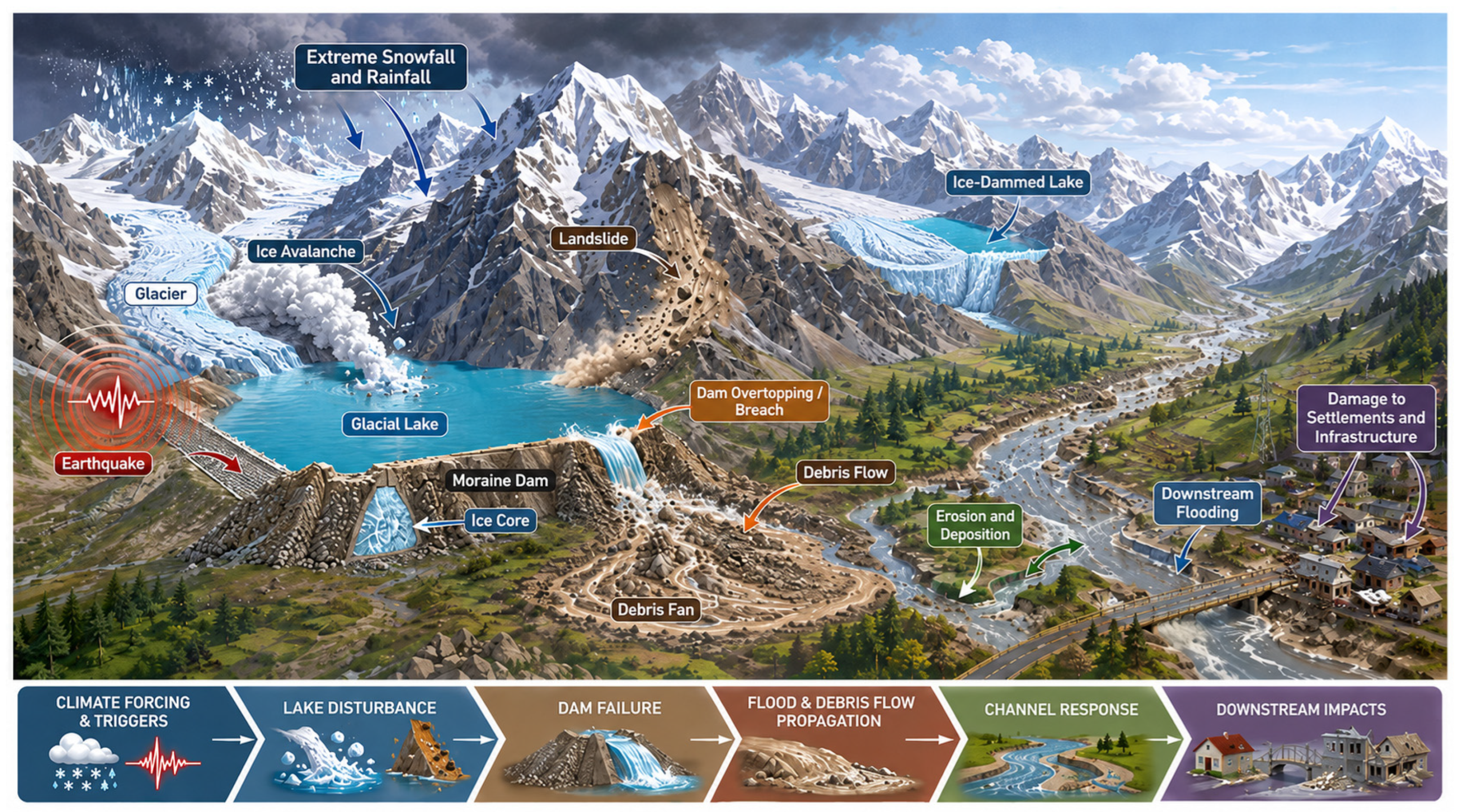
GLOFs occur when a glacial lake drains abruptly after the stability of its natural dam is compromised or overtopping occurs, producing sudden downstream flooding [7,8]. In HMA, GLOFs most commonly originate from moraine- and ice-dammed lakes, while outbursts from bedrock-dammed lakes are comparatively rare and are typically associated with overtopping [9,10,11]. The likelihood of outburst is conditioned by hydroclimatic variability, which regulates meltwater supply, lake filling, and dam stability over time [12,13]. Outburst initiation is also frequently associated with discrete external disturbances that destabilize the dam or promote overtopping, including earthquakes, cloudbursts, ice or rock avalanches, landslides, and related slope failures, which may breach the dam directly or induce sudden lake-level rise and overflow [1,14]. Figure 1 illustrates the GLOF hazard chain, including erosion–deposition processes and downstream damage pathways. In this review, GLOF hazard refers to the physical outburst process and associated flood or debris-flow intensity, including outburst susceptibility, flow depth, velocity, and inundation extent. GLOF risk is used in the formal disaster-risk sense as the potential for adverse consequences arising from the interaction of hazard, exposure, and vulnerability.
Long-term glacial-lake inventories for the HMA region provide the essential data foundation for GLOF research. Multi-temporal Landsat-based inventories have documented substantial changes in glacial-lake number, area, and spatial distribution, including HMA-wide inventories for 1990 and 2018 [6], Third Pole inventories for approximately 1990, 2000, and 2010 [15], and HMA lake-area change assessments extending to 2020 [16]. Regional studies have further provided important long-term evidence for specific mountain belts, including Himalayan lake-change assessments for 1990–2015 [17], Nepal Himalaya inventories for 1977–2017 [18], and northwestern Indian Himalaya inventories for 1984–2016 [19]. More recent annual products, such as the 30 m Hi-MAG glacial-lake dataset for 2008–2017 [20], have improved the temporal resolution of glacial-lake monitoring across HMA. Together, these inventories show that glacial lakes have generally expanded in many glacierized parts of HMA, although the magnitude and timing of change vary strongly among sub-regions. They also provide the baseline information needed for lake-volume estimation, susceptibility screening, historical GLOF interpretation, and future hotspot assessment. However, inventory comparisons must consider differences in minimum lake-area threshold, glacier-proximity rule, lake-type definition, seasonal image selection, and manual quality-control procedures, because these methodological choices strongly affect lake counts, mapped area, and the identification of potentially dangerous lakes.
Many studies suggest that GLOF hazard is likely to increase across HMA, particularly in basins with debris-covered glaciers and unstable moraines [5,17,21,22]. Model-based assessments further indicate substantial growth in future glacial-lake area and associated hazard potential during the 21st century in HMA [21,23]. However, robust projection of the timing, magnitude, and frequency of future GLOFs in HMA remains difficult because key controls are still poorly constrained, including incomplete event inventories, limited field measurements of lake and dam properties, and uncertainty in future glacier mass loss and climate forcing [4,24,25].
In response, GLOF risk reduction in HMA increasingly combines lake-level interventions, early warning, preparedness planning, land-use regulation, and governance coordination across lake, catchment, and community scales [24,26,27]. However, implementation remains uneven in remote and transboundary mountain regions because monitoring, maintenance capacity, institutional roles, and cross-border coordination are often limited. Therefore, it is necessary to evaluate how remote-sensing evidence can better support practical risk-reduction planning and implementation across HMA.
Despite the growing body of work, recent review articles have addressed GLOF hazards from different spatial and thematic perspectives. Zhang et al. [3] provided a broad global critical review of glacial-lake and GLOF characteristics, changes, future hazards, and risk frameworks. Ahmed et al. [24] reviewed glacial-lake expansion and associated GLOFs in the Himalayan region, while Ahmed [27] provided a global overview of GLOF hazard and risk-management strategies. Nurakynov et al. [28] synthesized advances in remote sensing for GLOF monitoring and risk assessment, whereas Shah and Ishtiaq [29] focused on adaptation strategies in the Hindu Kush Himalaya. Bazai et al. [30] examined surge-glacier-related GLOF hazards in the Karakoram, emphasizing ice-dammed lake formation and outburst processes. These studies provide important foundations, but their spatial focus, thematic scope, methodological depth, and management emphasis differ considerably. Moreover, existing reviews have not yet systematically integrated HMA-specific historical GLOF evidence, glacial-lake inventory development, Earth-observation methods, future hazard changes, uncertainty sources, and operational risk-reduction strategies within a single remote-sensing-oriented analytical framework.
Therefore, this review provides an HMA-focused, remote-sensing-oriented critical synthesis of GLOFs by integrating historical evidence, glacial-lake inventory development, assessment methods, future hazard changes, uncertainty sources, and risk-reduction strategies. Specifically, this review aims to: (i) synthesize glacial-lake evolution and documented GLOF characteristics, including dam type, failure mode, and triggering conditions; (ii) compare remote-sensing and modelling approaches for lake mapping, volume estimation, susceptibility screening, and flood simulation; (iii) identify where and why GLOF hazard may intensify across HMA sub-regions; and (iv) evaluate how Earth-observation evidence can support early warning, structural and non-structural measures, governance coordination, and implementation priorities.

2. Review Design, Literature Search, and Evidence Synthesis

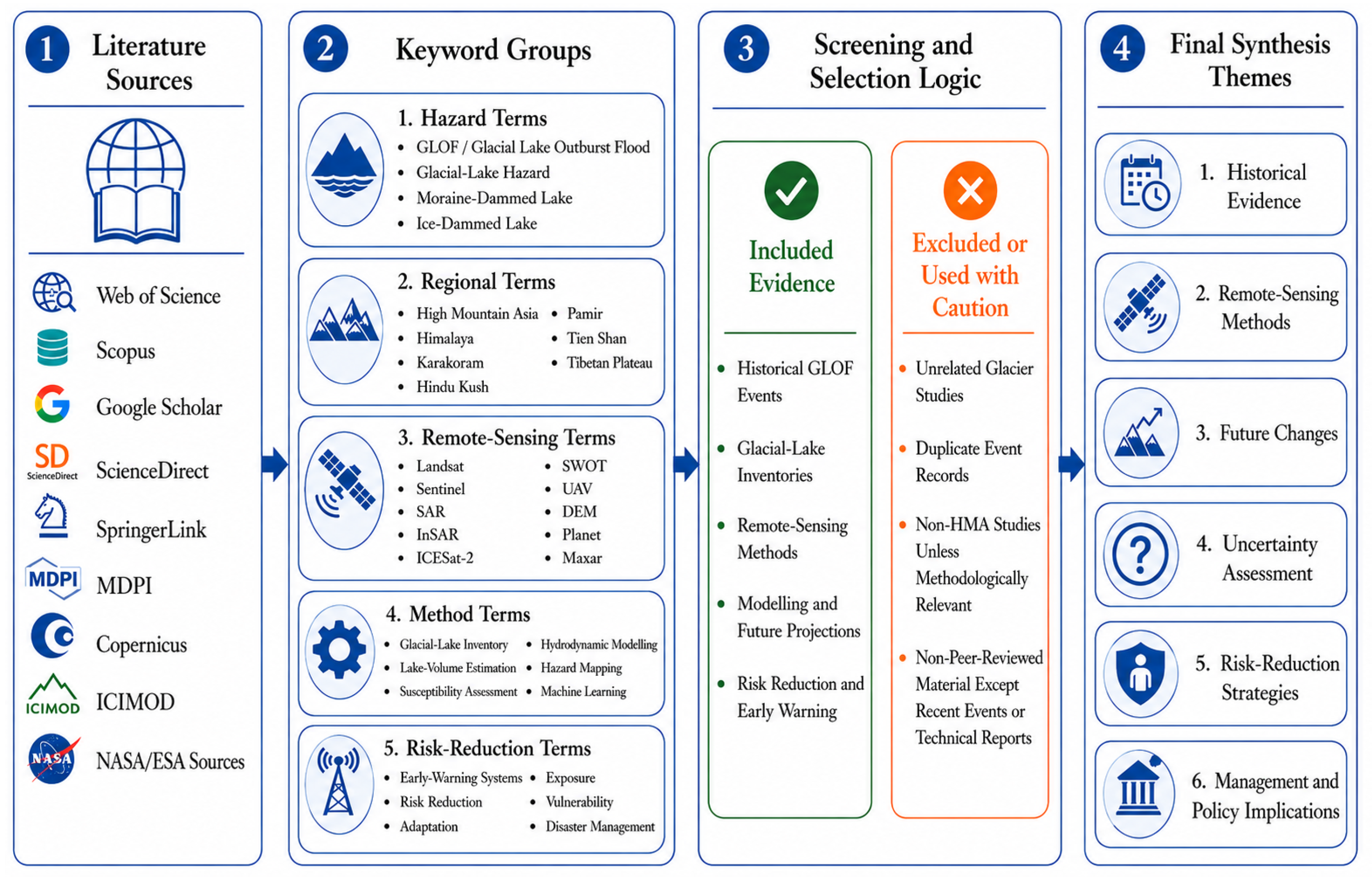
This review was designed as a structured critical narrative synthesis to integrate evidence on glacial-lake evolution, historical GLOF occurrence, remote-sensing and modelling approaches, future hazard changes, and risk-reduction strategies across HMA. The literature was identified from major scientific databases and technical sources, including Web of Science, Scopus, Google Scholar, ScienceDirect, SpringerLink, MDPI, Copernicus publications, ICIMOD reports, and relevant NASA, ESA, and national/international technical documents. The search combined terms related to hazard processes, regional context, remote-sensing datasets, methodological approaches, and risk management, including “GLOF/glacial lake outburst flood”, “glacial lake hazard”, “High Mountain Asia”, “Himalaya”, “Karakoram”, “Hindu Kush”, “Pamir”, “Tien Shan”, “Tibetan Plateau”, “glacial lake inventory”, “remote sensing”, “Landsat”, “Sentinel”, “SAR”, “InSAR”, “ICESat-2”, “SWOT”, “UAV”, “DEM”, “lake-volume estimation”, “susceptibility assessment”, “hydrodynamic modelling”, “hazard mapping”, “early warning”, and “risk reduction”. The overall search scope and evidence-synthesis framework are summarized in Figure 2.
Studies were prioritized when they met at least one of the following criteria: (i) they reported historical GLOF events or version-controlled GLOF inventories relevant to HMA; (ii) they developed or applied glacial-lake inventories, lake-area change analysis, lake-volume estimation, susceptibility screening, breach modelling, flood routing, or downstream exposure assessment; (iii) they used satellite observations, geospatial analysis, field validation, UAV data, hydrodynamic modelling, or machine-learning approaches relevant to GLOF assessment; or (iv) they discussed risk-reduction, early-warning, policy, governance, or adaptation strategies for high-mountain GLOF-prone regions. Studies outside HMA were considered only when they provided transferable methodological insights for glacial-lake mapping, GLOF modelling, uncertainty assessment, or risk management. Purely local glacier studies with no direct relevance to glacial lakes, GLOFs, remote sensing, modelling, or risk reduction were excluded. Non-peer-reviewed sources were used selectively for recent events, technical inventories, project information, and operational risk-reduction examples where the peer-reviewed literature was not yet available.
For historical event synthesis, version-controlled GLOF databases and published inventories were used as the primary evidence base. Recent events that occurred after the coverage period of major inventories were treated as case-study additions rather than automatically merged into the statistical database. To reduce duplication, reported events were cross-checked using available information on location, date, lake name, dam type, trigger, downstream impact, and original source. Where information on dam type, sub-region, or process attribution was incomplete, events were retained but clearly identified as unknown or unclassified. The evidence was then organized by sub-region, dam type, remote-sensing dataset, modelling approach, uncertainty source, and management relevance. This approach allowed to evaluate not only what has been reported across HMA, but also how differences in datasets, mapping thresholds, modelling assumptions, and reporting quality influence the interpretation of historical evidence, future hazard assessment, and practical risk-reduction strategies.

3. Remote-Sensing Methods Used for the Assessment of Glacial Lakes and GLOFs in HMA

3.1. Geographic Scope of High Mountain Asia

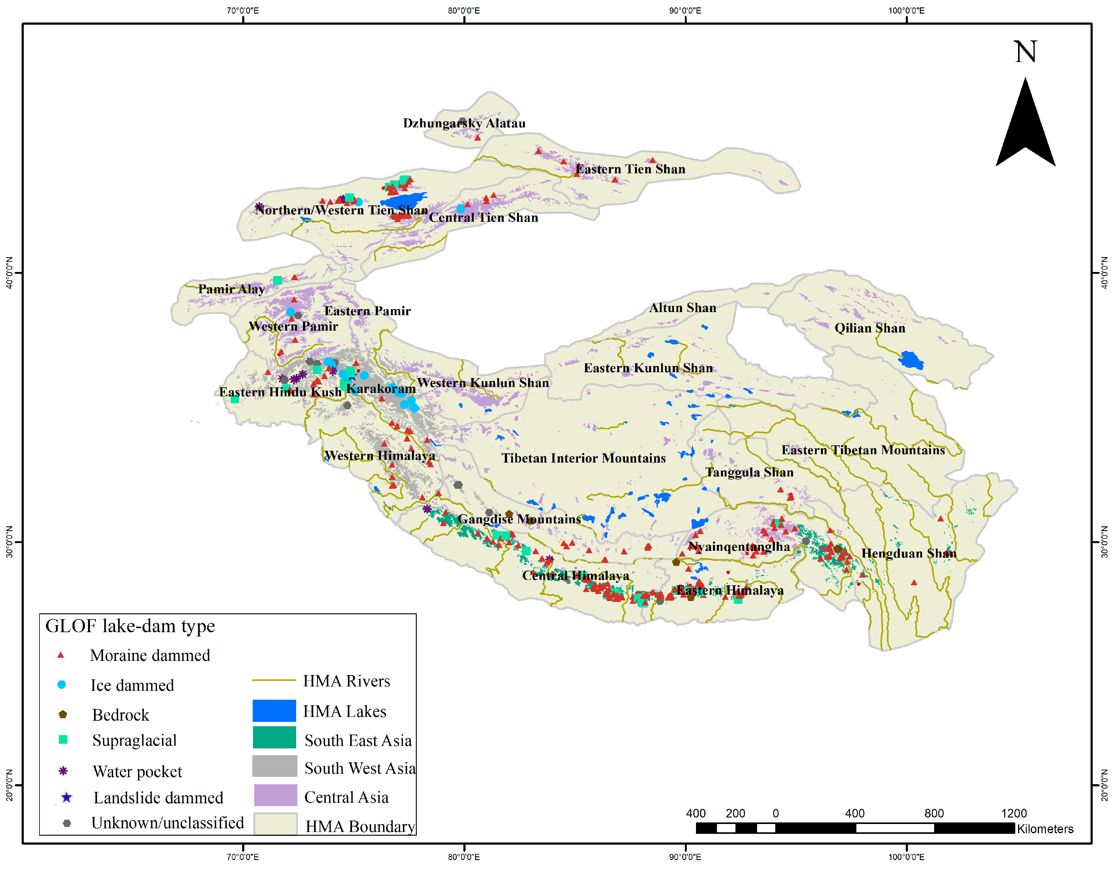
High Mountain Asia (Figure 3) is a mountain–plateau system comprising the Hindu Kush, Karakoram, Himalaya, Kunlun, Pamir, Tian Shan, and the Tibetan Plateau, extending across Afghanistan, Pakistan, India, Nepal, Bhutan, China, Tajikistan, Kyrgyzstan, Kazakhstan, and Uzbekistan [31,32]. HMA spans strong gradients in elevation and relief, from deeply incised mountain terrain to high-elevation plateaus, which creates sharp spatial contrasts in local climate and cryospheric conditions [33,34]. These contrasts also make regionally consistent hazard assessment difficult using field observations alone, thereby increasing the importance of remote sensing and geospatial analysis for documenting glacial-lake distribution and GLOF-related conditions across HMA. These contrasts shape glacier regimes and meltwater pathways and contribute to pronounced heterogeneity in where glacial lakes form and how they evolve among sub-regions. The geographic breadth and physiographic heterogeneity of HMA provide the essential spatial context for region-scale synthesis of glacial-lake and GLOF-related evidence.
HMA contains the largest concentration of glaciers outside the polar regions, sustaining major transboundary river systems such as the Indus, Ganges, Brahmaputra, and Mekong [36]. The HMA has over 95,000 glaciers and around 30,000 glacial lakes that combined cover about 2000 km2 [6,37]. These headwaters support downstream water and food security and underpin livelihoods in both mountain communities and densely populated lowlands [32,38]. Because river networks cross national boundaries, upstream cryospheric change can influence water availability, hydropower reliability, and resource planning across multiple countries. This strong downstream dependence makes HMA strategically important for understanding climate-sensitive hydrological change and related hazards.
The climate of HMA reflects the combined influence of the South and East Asian monsoons and midlatitude westerlies, which shape seasonal moisture transport and circulation over the Tibetan Plateau and surrounding ranges [39,40]. This circulation produces strong spatial gradients in precipitation amount and seasonality, with a pronounced summer peak on monsoon-influenced southern and eastern slopes and greater westerly influence toward the northwest [39,40]. The plateau environment is characterized by strong solar radiation, low mean temperatures, and a large diurnal temperature range, all of which influence snow persistence and melt timing [31,41]. In addition, warm extremes such as heatwaves can temporarily intensify meltwater production and lake-level rise during the melt season.

3.2. Glacial-Lake Mapping and Inventory Generation

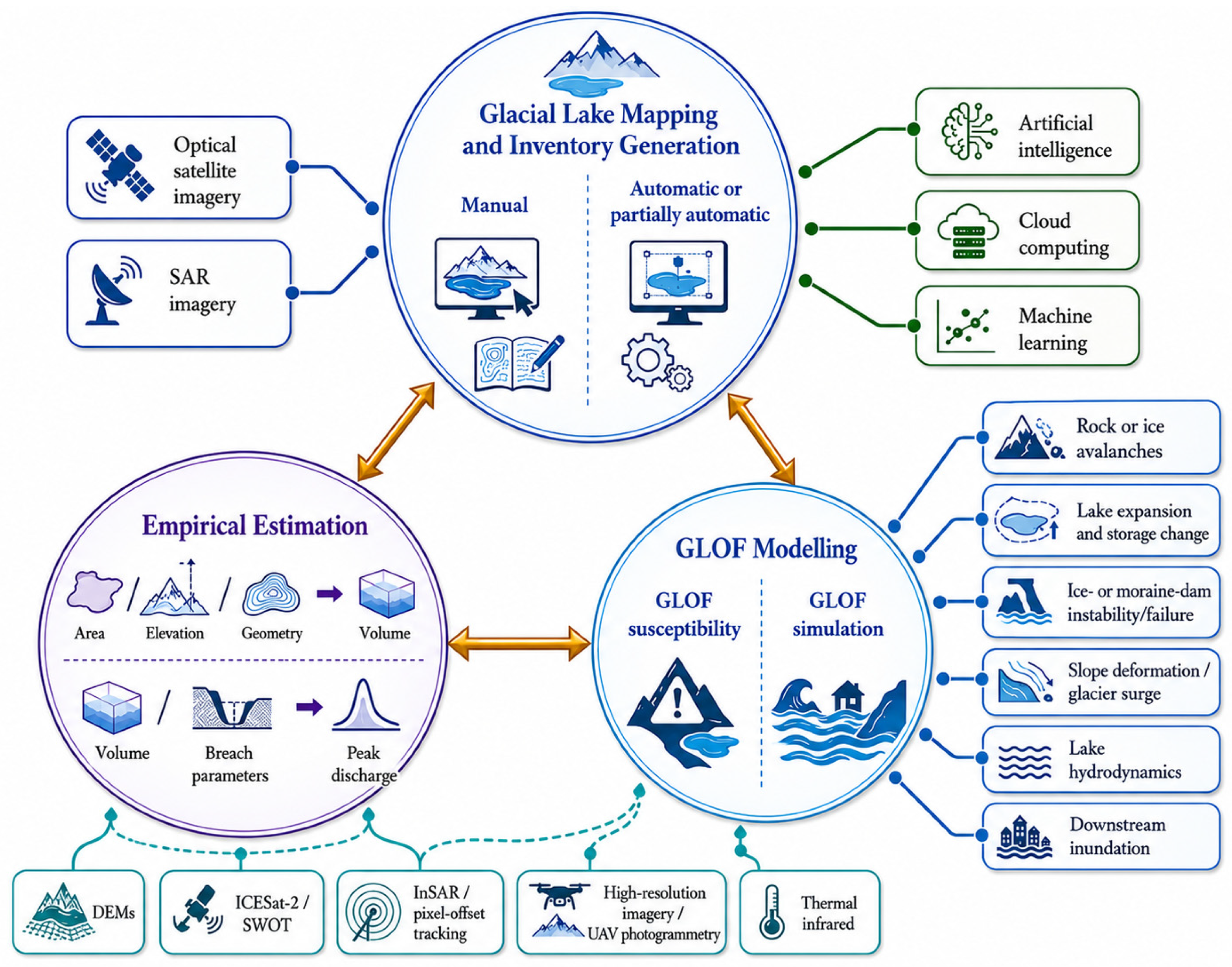
Comprehending glacial-lake attributes, distribution, and evolution is essential for evaluating and monitoring GLOF hazard in HMA because lake outlines and morphometric descriptors are the starting inputs for hazard screening and modelling workflows (Figure 4). In HMA, most region-scale glacial-lake assessments rely primarily on remote sensing because field-based mapping is logistically difficult, spatially uneven, and often impossible across many high-elevation and transboundary settings. Mapping has progressed from expert-led manual delineation of high-resolution optical and radar imagery, which can be highly accurate in complex terrain but is labour-intensive and may be sensitive to observer bias and data gaps [42,43]. Regional-scale efforts increasingly rely on automated or semi-automated classification using spectral water indices, most commonly the Normalized Difference Water Index (NDWI), to delineate lake boundaries consistently over large areas [6,44]. The expansion of satellite archives, together with cloud-computing platforms, has enabled reproducible multi-temporal processing for systematic lake inventories and change detection [45]. More recently, artificial intelligence and machine-learning segmentation have further improved the efficiency of large-area mapping in remote parts of HMA, especially when integrated with robust quality-control steps [46,47,48].
Furthermore, Landsat imagery remains widely used for NDWI-based lake mapping because its long, consistent archive supports repeated observations and multi-decadal inventories [5,49,50]. However, optical classifications can be degraded by seasonal snow and ice cover on lakes, mountain shadows, turbid water, and persistent cloud cover, all of which can increase omission and commission [50]. Additional uncertainty may arise from differences in image acquisition season, minimum mapping thresholds, and the treatment of supraglacial ponds, ice-contact lakes, and partially debris-covered margins, which can reduce comparability among inventories. Spaceborne SAR reduces cloud and illumination constraints, but its operational time series is often shorter than Landsat records and lake-surface backscatter can vary with roughness conditions, so SAR is typically used to complement optical mapping or support validation and targeted case studies [42,51]. Even with cloud computing and advanced classifiers, expert visual inspection and targeted manual correction remain important to remove persistent misclassifications and maintain temporal consistency in long-term monitoring products [52]. Therefore, differences in sensors, classification workflows, mapping thresholds, seasonal image selection, and validation practice can produce non-trivial inconsistencies in lake counts, area estimates, and the identification of potentially dangerous lakes across HMA inventories. These issues become especially relevant when comparing and integrating region-scale datasets, as summarized in the key inventories of glacial lakes and GLOFs applied across HMA (Table 1). Therefore, lake inventories should be compared cautiously because methodological differences can materially affect lake counts, area estimates, and the identification of potentially dangerous lakes.

3.3. Emerging Remote-Sensing Capabilities for GLOF Monitoring and Process Interpretation

Conventional optical lake mapping based on Landsat, Sentinel-2, and water indices remains essential for multi-decadal glacial-lake inventories in HMA, but it represents only one component of remote-sensing-based GLOF assessment. Landsat-based inventories have enabled region-wide and multi-decadal mapping of lake area and shoreline change, while annual 30 m products such as Hi-MAG provide consistent HMA glacial-lake coverage for recent decades [5,20]. However, lake outlines alone are insufficient for GLOF assessment because hazard interpretation also depends on lake level, volume change, dam geometry, glacier–lake contact, slope instability, ice-dam deformation, glacier-surge dynamics, flood and debris-flow pathways, and downstream exposure. Therefore, a more complete Earth-observation framework requires linking each sensor or method to specific GLOF-relevant variables and uncertainty sources (Table 2).
Satellite altimetry is becoming increasingly important for monitoring lake-surface elevation and estimating water-storage change in remote mountain basins. ICESat-2 ATLAS photon-counting laser altimetry provides elevation measurements that can be used to retrieve lake-surface height and, in optically clear shallow-water settings, support proxy bathymetry or lake-depth estimation when combined with optical imagery [59,60]. Studies on Tibetan Plateau lakes have demonstrated that ICESat-2 photon data can help reconstruct lakebed topography and water depth where photons penetrate the water column and where adequate denoising and track coverage are available [59,60]. SWOT further expands this capability by providing wide-swath measurements of surface-water elevation and extent for lakes, reservoirs, rivers, and wetlands, offering new opportunities to monitor lake-level change and downstream hydrological response in remote high-mountain catchments [61,62]. However, both ICESat-2 and SWOT have limitations in steep terrain, including track spacing, lake-size constraints, water-surface roughness, snow and ice cover, shoreline complexity, and data gaps in narrow valleys.
Radar-based approaches provide complementary information where optical imagery is limited by cloud, seasonal snow, shadow, or short revisit windows. Sentinel-1 and ALOS-2 SAR can support all-weather lake and flood mapping, while InSAR can detect deformation of ice dams, glacier termini, moraine slopes, and potentially unstable slopes adjacent to proglacial lakes [63,64,65,66,67]. Optical and SAR pixel-offset tracking are also important for identifying slope motion, glacier surging, and rapid ice-flow changes that may precede lake impoundment, dam failure, or impulse-wave generation. These methods are particularly relevant in the Karakoram, western Kunlun, Pamir, and related surge-glacier environments, where ice-dammed lake formation and repeated drainage events are closely linked to glacier dynamics [63,67]. For example, studies of Kyagar and Shisper/Shispare glaciers show that glacier surface velocity, terminus advance, ice-dam formation, and lake evolution can be reconstructed from multi-source optical, SAR, DEM, and feature-tracking datasets [63,64,65,66,67].
High-resolution commercial satellite imagery from Planet, Maxar, Pléiades, and similar constellations improves sub-event monitoring and event reconstruction by resolving narrow breach channels, shoreline changes, landslide sources, debris-flow deposits, damaged infrastructure, and post-event lake-level changes [68,69,70]. Such imagery is especially valuable for recent events, including the 2023 South Lhonak GLOF, where optical imagery, InSAR deformation analysis, and multi-source remote-sensing observations supported pre- and post-event interpretation of lake drainage, slope instability, dam breaching, and downstream impacts [68,69,70]. Thermal-infrared and land-surface-temperature products can complement optical and radar data by identifying thermal anomalies associated with glacier or moraine thermal stress, wet debris, exposed or buried ice, and possible englacial drainage pathways where spatial resolution and atmospheric conditions are suitable [4,70]. Nevertheless, thermal data remain underused in regional HMA GLOF studies because of coarse spatial resolution, mixed-pixel effects, complex terrain illumination, and limited field validation.
Overall, no single sensor provides a complete GLOF-monitoring solution. Optical imagery is best suited for long-term lake-area inventories, SAR improves all-weather mapping, altimetry provides elevation and storage-change information, InSAR and offset tracking reveal deformation and movement precursors, high-resolution imagery supports event-scale interpretation, and DEM products provide the topographic basis for dam geometry and downstream flood routing [4,5,20,59,60,61,62,63,64,65,66,67,68,69,70]. The most robust future GLOF assessment frameworks in HMA will therefore require multi-sensor fusion, uncertainty reporting, and targeted field validation rather than reliance on a single mapping product.
Table 2. Critical comparison of remote-sensing capabilities for GLOF monitoring and assessment in High Mountain Asia (HMA).
Sensor/PlatformTypical Spatial/Temporal ResolutionGLOF-Relevant Retrieved VariableMain Strengths for HMA GLOF ResearchKey LimitationsReference
Landsat Series30 m; 16-day revisit; archive from the 1970s/1980s depending on missionLake area, shoreline migration, lake expansion, glacier–lake contactBest long-term optical archive for multi-decadal inventories and historical change detection.Cloud, seasonal snow/ice, terrain shadow, mixed pixels, and limited sub-event detail.[6,20]
Sentinel-2 MSI10–20 m; approximately 5-day revisit with two satellitesLake boundaries, small lake changes, glacier–lake contact, post-event shoreline changeHigher spatial and temporal detail than Landsat; useful for annual to seasonal monitoring and recent event interpretation.Cloud, snow, mountain shadow, turbidity, and strong sensitivity to seasonal image selection.[5,20]
Sentinel-1 SAR10 m class; 6–12-day repeat depending on orbit availabilityOpen-water extent, flood traces, wet surfaces, lake-surface roughnessCloud-independent observations during monsoon/cloudy periods; complements optical lake mapping.Layover and radar shadow in steep terrain; wind, rough water, and frozen surfaces may complicate interpretation.[68,70]
Sentinel-1/ALOS-2 InSAR10–30 m class; repeat-pass interferometryIce-dam deformation, moraine/slope instability, glacier-terminus displacement, precursor deformationDetects deformation not visible in optical imagery; valuable for unstable slopes and dams around glacial lakes.Temporal decorrelation over snow, ice, water, and debris; geometric distortion in high relief; requires careful processing.[68,70]
Optical/SAR Pixel-Offset TrackingSensor-dependent; days to months depending on image pairsGlacier velocity, surge propagation, slope displacement, landslide motion, pre-failure movementCaptures rapid movement and surge dynamics that can generate ice-dammed lakes or impulse-wave triggers.Requires suitable image pairs and texture; affected by snow cover, shadow, decorrelation, and geolocation error.[70,71,72]
ICESat-2 ATLASAlong-track photon-counting laser altimetry; approximately 17 m footprint; repeat-track samplingLake-surface elevation, water-level change, shallow-water/proxy bathymetry, storage-change constraintsProvides elevation information for remote lakes; photon data can support water-depth/bathymetry estimation in suitable clear-water conditions.Track spacing, small/narrow lake coverage, water turbidity, ice/snow cover, shoreline complexity, and slope effects.[59,73]
SWOTWide-swath Ka-band radar interferometry; ~21-day repeat; water bodies meeting mission size thresholdsWater-surface elevation, surface-water extent, storage change, river/lake hydrodynamic indicatorsSystematic surface-water elevation and extent measurements for lakes, rivers, reservoirs, and wetlands; new opportunity for remote basin monitoring.Mission data are recent; complex terrain, lake size, valley geometry, and algorithm maturity constrain high-mountain applications.[74,75]
Planet/Maxar/Pléiades and Other Very-High-Resolution Optical ImagerySub-metre to ~3 m; daily to tasking-based depending on providerBreach channels, landslides, debris-flow deposits, damaged infrastructure, lake drainage, shoreline changesResolves narrow breach channels and local geomorphic impacts; strong for post-event mapping and detailed case-study reconstruction.Cost, access restrictions, cloud dependence, limited historical continuity, and tasking constraints.[68,70,76]
UAV/Structure-from-Motion Photogrammetrycm–dm scale; campaign-basedDam geometry, outlet elevation, breach morphology, shoreline position, deposit thickness, local validation dataVery high spatial detail; useful for validating satellite products and planning site-level mitigation.Limited spatial coverage; requires field access, permissions, weather windows, and operational safety.[76]
Thermal Infrared/Land-Surface Temperature Products30–1000 m depending on sensor; revisit from daily to 16-day depending on productThermal anomalies, surface wetness/ice indicators, glacier/moraine thermal stress, possible seepage or buried-ice indicatorsCan complement optical/SAR indicators where thermal stress, buried ice, or englacial drainage pathways are suspected.Coarse resolution, mixed pixels, atmospheric effects, terrain illumination, and limited direct validation for GLOF precursors.[70,76]
DEMs: SRTM, ASTER, TanDEM-X, Copernicus DEM, UAV DEMs10–90 m for regional DEMs; cm–dm for UAV DEMs; static or repeat-basedDam height, freeboard proxy, slope, lake catchment geometry, flow path, inundation model input, exposure corridorEssential topographic basis for susceptibility screening, breach modelling, flood routing, and downstream exposure assessment.Vertical error, voids, radar penetration into snow/ice, temporal mismatch, glacier-surface change, and scale mismatch.[22,76]
Note: The table emphasizes GLOF-relevant variables and limitations rather than presenting one sensor as sufficient for all tasks. Resolution and revisit values are approximate and depend on mission mode, orbit, latitude, cloud/snow conditions, and data availability. Abbreviations: DEM, digital elevation model; InSAR, interferometric synthetic aperture radar; SAR, synthetic aperture radar; SWOT, Surface Water and Ocean Topography; UAV, uncrewed aerial vehicle.

3.4. Lake Volume Estimation and Empirical Equations Applied in HMA

Lake-outline mapping alone is not sufficient for hazard quantification because lake volume provides the physical upper bound on water available for release and strongly conditions plausible outburst magnitude (Figure 4) [77]. Because direct bathymetric surveys are scarce in high-elevation environments, many regional assessments in HMA estimate lake volume indirectly from remotely sensed lake area, topographic context, and empirical scaling relationships [5,78,79]. The empirical relationships compiled for HMA include both global and regional calibrations and show substantial variation in sample size, explained variance, and domain of applicability (Table 3), reflecting differences in lake type, geomorphic setting, and calibration datasets [5,78,80]. For example, Table 3 includes relationships developed for lakes above specific size thresholds (e.g., >0.5 km2), for moraine-dammed lakes, for proglacial lakes, and for different HMA sub-regions, implying that selection should match lake type and mapping threshold [5,81]. Table 3 also shows that some relationships incorporate additional shape terms beyond area alone, which can improve performance where suitable calibration data exist [80]. Accordingly, uncertainty in remotely sensed lake extent, seasonal image selection, and inventory definition can propagate directly into volume estimates and influence subsequent hazard interpretation.
Once volume is estimated, studies commonly use empirical formulations and simplified breach approaches to generate plausible peak discharge and hydrographs for downstream simulation (Figure 4) [82,83,84]. The reliability of volume and discharge estimation therefore depends on (i) the quality and temporal consistency of lake outlines, (ii) the selection of an appropriate area–volume relationship (Table 3), and (iii) the transparency with which uncertainty is propagated into subsequent modelling steps. Where feasible, targeted field measurements and UAV/photogrammetry-derived geometry can strengthen calibration datasets and reduce uncertainty, but regional screening still largely depends on empirical relationships because bathymetry remains limited for most HMA lakes [85,86,87]. As a result, it is good practice to report the chosen relationship, its calibration setting (global vs. HMA sub-region), and the relevant lake-size/domain constraints (Table 3).
Table 3. Empirical area–volume relationships for glacial-lake volume estimation.
FormulaStudied RegionNR2ReferenceApplicability/Note
V = 0.1217A1.4129Global150.95[74]Bedrock-, ice-, and moraine-dammed lakes
V = 0.05057A1.2884Global420.38[78]Bedrock-, ice-, and moraine-dammed lakes
V = 0.1746A1.3725Global300.60[78]Bedrock-, ice-, and moraine-dammed lakes
V = 0.3211A1.324Global570.57[78]Bedrock-, ice-, and moraine-dammed lakes
V = 0.1697A1.3778Global450.75[78]Bedrock-, ice-, and moraine-dammed lakes
V = 1.0 × 10⁻¹⁷A1.76Global1220.99[5]Lakes > 0.5 km2
V = 0.0354A1.3724HMA (Himalayas)200.50[88]Moraine-dammed lakes
V = 0.087A1.434HMA (Himalayas)200.50[88]Moraine-dammed lakes
V = 4.067 × 10⁻²⁰A1.184 − 3.218 × 10⁻¹⁵(RmaxW/maxL)HMA (Central Himalayas)270.96[80]Lakes ≥ 0.1 km2; includes shape-ratio term
V = 5.574 × 10−27.73A2.455 − 2.005 × 10⁻¹⁶(RmaxW/maxL)HMA (Central Himalayas)700.80[80]Lakes < 0.1 km2; includes shape-ratio term
V = 1.26 × 10⁻²⁶A2 + 5.6 × 10⁻²⁴A + 1.32 × 10⁻¹⁷HMA (Himalayas)350.98[80]Lakes ≥ 0.5 km2
V = 2.35 × 10⁻²⁵A1.4083HMA (Himalayas)2270.90[80]Lakes < 0.5 km2
V = 5.5 × 10−0.5A1.25HMA (Himalayas)16N/A[89]Moraine-dammed lakes; South Lhonak case set
V = 0.0578A1.4683HMA (Himalayas)330.93[90]Moraine-dammed lakes
V = 4.3244 × 10⁻¹⁴A1.5307HMA (Himalayas)15N/A[91]Moraine-dammed lakes
V = 5.22 × 10⁻¹⁸A1.1766HMA (Himalayas)60.99[89]Moraine-dammed lakes
V = 4.93 × 10⁻¹⁶A0.9304HMA (North Himalayas)150.99[31]Moraine-dammed lakes
V = 0.096A1.426HMA (Central Himalayas)15N/A[92]Ice-, moraine-, and supraglacial-dammed lakes
V = 4 × 10⁻⁵A2 + 5.0564AHMA (Western Himalayas)N/A0.96[81]Proglacial lakes
Note: V denotes glacial-lake volume and A denotes glacial-lake surface area. Unit conventions follow the original references listed in the table and should be checked before direct application, because empirical area–volume relationships may be reported using different combinations of area and volume units. Where equations are applied after unit harmonization, V is expressed in m3 and A in m2. N is the number of bathymetric measurements used to develop the relationship; R2 denotes the coefficient of determination. RmaxW/maxL is the ratio of maximum lake width to maximum lake length. N/A = not available or not applicable. Each equation should be applied only within the lake-type, regional, and area-range domain reported by the original source.

3.5. Susceptibility Screening and Hazard Classification

Lake identification and volume estimation are necessary but insufficient; hazard evaluation also requires assessing whether a lake–dam system is susceptible to failure under plausible initiating processes and internal weakening (Figure 4). Susceptibility screening typically integrates geomorphological and hydrological indicators such as dam freeboard, lake and catchment geometry, glacier–lake contact, and surrounding slope conditions, alongside evidence of past instability where available [43,93,94]. Process understanding distinguishes external disturbances that can destabilize dams (e.g., avalanches, landslides, extreme precipitation, seismic shaking) from intrinsic degradation mechanisms (e.g., seepage, piping, melting of buried ice, progressive erosion) that reduce dam integrity over time [94]. These distinctions matter because moraine-dammed lakes often fail by overtopping erosion or internal piping, whereas ice-dammed lakes may drain abruptly through flotation or subglacial conduit development, implying different indicator sets and scenario assumptions [95,96]. However, susceptibility classification remains highly sensitive to the quality of remotely sensed inputs, the completeness of historical event inventories, and the transferability of screening criteria across contrasting HMA sub-regions.
Operational screening is implemented using multi-criteria decision analysis or statistical and machine-learning models that integrate physical predictors with available event inventories to classify lakes into hazard categories [43,97]. Remote-sensing predictors (e.g., glacier retreat metrics or thermal anomalies) increasingly support screening in data-scarce areas by extending spatial coverage across HMA [43]. At the same time, machine-learning applications remain constrained by limited GLOF cases, imbalanced datasets, and uneven regional reporting, which can reduce model robustness and generalizability if validation is weak or geographically narrow. However, model transferability remains constrained by incomplete event documentation and reporting bias, so susceptibility outputs are most defensible when presented as prioritization tools rather than deterministic predictions [79]. Consistency in baseline datasets is also important, since different lake and GLOF inventories differ in spatial coverage, time period, and mapping thresholds, as summarized in Table 1. Overall, susceptibility screening is most useful as a regional prioritization tool when field data are limited, whereas detailed process-based assessment should be reserved for priority lakes where lake geometry, dam condition, slope instability, and downstream exposure require closer evaluation.

3.6. Breach Modelling and Hydrodynamic Simulation of GLOFs

Hydrodynamic simulation typically links (i) breach initiation and growth to generate a source hydrograph and (ii) downstream flood routing to estimate inundation extents, flow depths, and velocities for hazard mapping and engineering design (Figure 4) [77,98]. In most HMA applications, these simulations depend heavily on remote-sensing-derived inputs, including lake extent, dam geometry, topography/DEMs, channel alignment, land cover, and exposure layers for downstream impact assessment. Breach development is sensitive to dam composition and structure, breach geometry and growth rate, and lake level, and uncertainty in these inputs often dominates uncertainty in peak discharge and inundation [84,99]. Scenario-based modelling is therefore widely used to represent alternative failure mechanisms such as overtopping erosion, internal piping, and impulse-wave overtopping from mass movements into lakes [99]. These hydrographs provide consistent boundary conditions for routing models and allow comparison across lakes under standardized assumptions.
A range of hydrodynamic tools is applied in HMA depending on terrain complexity and the processes that must be represented. As summarized in Table 4, widely used models include HEC-RAS (commonly implemented in 1D/2D forms based on Saint-Venant/shallow-water equations) and other platforms that can represent inundation mapping and, in some configurations, sediment transport, requiring inputs such as DEMs, breach hydrographs or breach parameters, and channel/floodplain roughness. Where process-chain behaviour and debris-laden flows are important, mass-flow and two-phase tools (e.g., RAMMS, r.avaflow) are increasingly used to represent flow transformation and sediment entrainment under steep mountain conditions [98,100]. Model performance therefore depends not only on hydraulic formulation, but also on the spatial resolution, vertical accuracy, and temporal representativeness of the remote-sensing-derived terrain and boundary-condition data used to initialize simulations. The models, dimensionality, typical inputs, and representative HMA applications should be reported consistently to support comparability, as structured in Table 4. In practice, model selection should follow the dominant process and decision need: 1D/2D hydraulic models are most suitable for flood routing and inundation mapping, while mass-flow or two-phase models are more appropriate where debris entrainment, landslide-generated impulse waves, or coupled process chains are expected.

4. Historical GLOFs and Documented Losses in HMA

4.1. Historical Records and Sources of GLOFs

Historical GLOFs in HMA represent rapid lake drainage following failure or overtopping of natural dams, most commonly moraine or ice, releasing impounded water and often debris in short-duration floods [33,94]. Here, the historical GLOFs record is reconstructed from multiple evidence streams, including satellite imagery, geomorphic and sedimentary traces, river-gauge information, published reports, and documented accounts [33]. However, triggers and failure modes are frequently unknown or inferred because observations at the time of failure are sparse, and diagnostic evidence may be short-lived or never recorded in remote terrain [3]. These limitations imply that catalogues are informative but incomplete, and apparent spatial–temporal patterns should be interpreted with explicit consideration of reporting bias and uneven observation effort through time [122,123].
Based on available compilations, approximately 711 reported GLOF records are identified across HMA for the historical synthesis [2]. These records include both dated events and records with incomplete temporal attribution; therefore, decadal analyses were based only on records with available event-year information, whereas sub-regional and lake–dam type summaries were calculated from the full compiled dataset. The records were organized using a single event-level dataset following the HMAGLOFDB structure, and the regional and lake–dam type percentages were calculated relative to the full compiled total. The HiMAP-based sub-regional grouping shows that reported GLOFs are concentrated mainly in the Tien Shan (n = 255; 35.9%), Karakoram/Western Kunlun (n = 160; 22.5%), Himalaya East/Hengduan Shan (n = 137; 19.3%), and Himalaya West/Central (n = 115; 16.2%). Smaller proportions are reported from the Hindu Kush (n = 19; 2.7%), Pamir and Alay (n = 13; 1.8%), and Tibet and Plateau/Fringe regions (n = 4; 0.6%), while records with insufficient information for sub-regional attribution are retained as unknown/unclassified (n = 8; 1.1%). These statistics should be interpreted as reported database records rather than a complete census of all historical outbursts, because observation intensity, source availability, and event documentation differ among sub-regions and across time [122,123].
For statistical reporting, GLOF records were grouped using a HiMAP/HMAGLOFDB-based regional aggregation. The detailed physiographic sub-regions shown in Figure 3 were aggregated into the broader categories used in Table 5 as follows: Dzhungarsky Alatau, Northern/Western Tien Shan, Central Tien Shan, and Eastern Tien Shan were grouped as “Tien Shan”; Pamir Alay, Western Pamir, and Eastern Pamir as “Pamir and Alay”; Karakoram and Western Kunlun Shan as “Karakoram/Western Kunlun”; Western Himalaya and Central Himalaya as “Himalaya West/Central”; Eastern Himalaya, Gangdise Shan, Nyainqentanglha, and Hengduan Shan as “Himalaya East/Hengduan Shan”; and the remaining Tibetan Plateau and fringe sub-regions as “Tibet and Plateau/Fringe regions.” Records with insufficient spatial information were retained as “unknown/unclassified.”
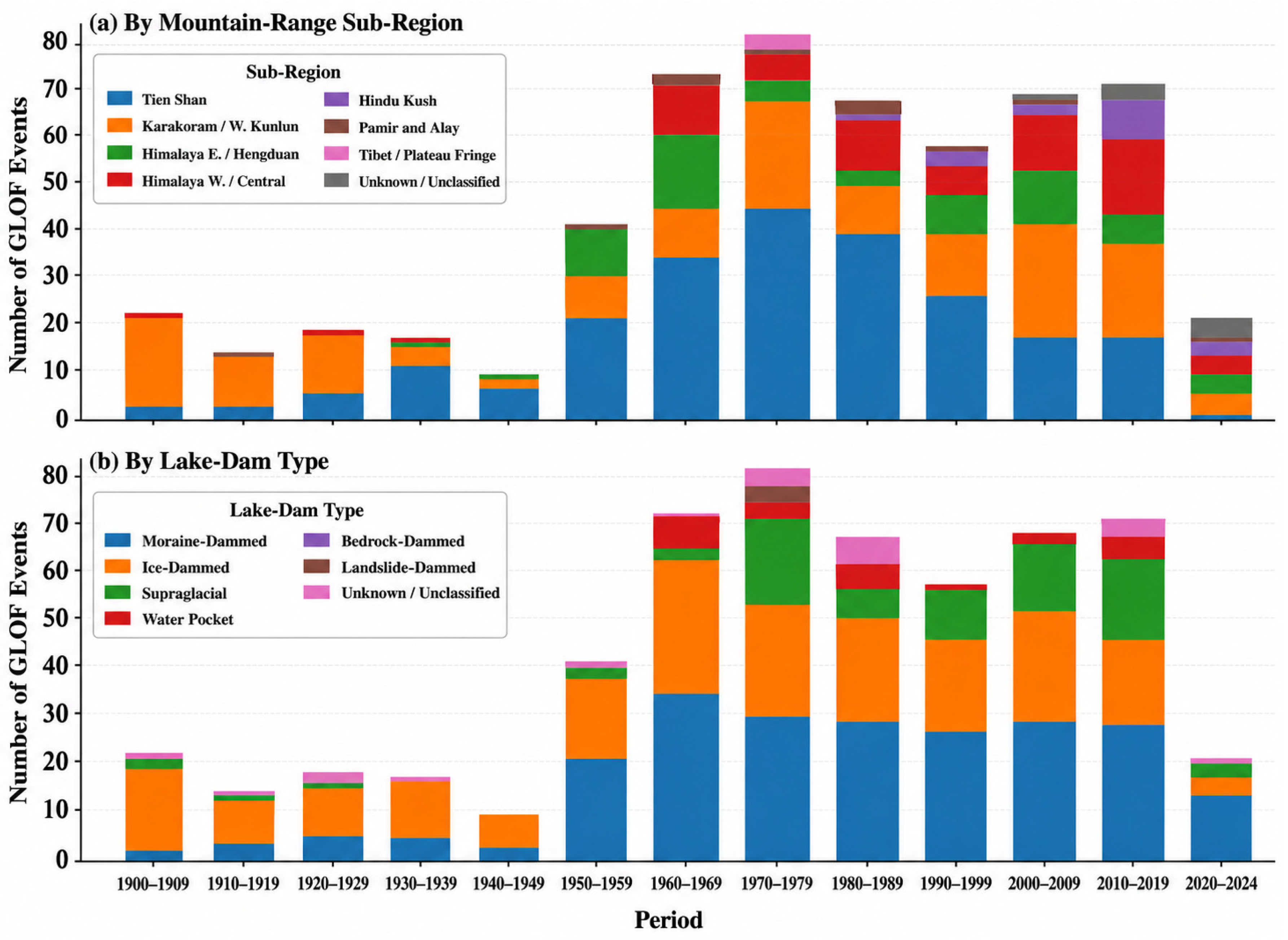
Decadal variability also differs by mountain-range sub-region and lake–dam type, highlighting that historical occurrence is not stationary in the reported record (Figure 5). The Tien Shan shows a strong mid-20th-century increase followed by a decline in the 1990s, whereas the Karakoram record exhibits multiple peaks beginning early in the 20th century, consistent with the occurrence of temporary lake formation associated with dynamic glacier behaviour in some basins. In the Himalaya and Hindu Kush, reported events show a more gradual rise, although totals remain lower than in the Tien Shan and Karakoram. These decadal patterns likely reflect both physical variability and major shifts in observation and reporting capacity, including the transition to satellite-era detection [122,123]. Accordingly, the historical record is best used to characterize event types, plausible process pathways, and regional contrasts, rather than to infer precise long-term frequency trends without careful bias treatment.

4.2. Historical GLOFs by Lake–Dam Type

4.2.1. Moraine-Dammed GLOFs

GLOFs in HMA arise from multiple lake–dam configurations, and the reported GLOFs are dominated mostly by moraine-dammed lakes. Moraine-dammed outbursts can be initiated by overtopping driven by mass movements or calving-related displacement waves, or by internal weakening processes such as seepage, piping, and melt-out of buried ice within unconsolidated dam material [94,96,124]. In the compiled record, moraine-dammed GLOFs account for ~53.2% (378/711) of reported GLOFs between 1900 and 2024, although their occurrence varies among sub-regions and lake settings [49,53]. Glacier-contact lakes can be especially sensitive to nearby disturbances, whereas detached proglacial lakes may become less exposed to some triggers as glacier–lake distance increases [125]. Overall, moraine-dammed events remain the largest contributor to reported historical GLOFs in HMA, consistent with the prevalence of moraine-impounded lakes in several mountain belts (Figure 3).

4.2.2. Ice-Dammed GLOFs

GLOFs from ice-dammed lakes are the second largest reported group, accounting for 207 records (29.1%) in the compiled dataset. Ice-dammed GLOFs are strongly controlled by glacier dynamics and drainage through or beneath the ice dam, including flotation and enlargement of subglacial conduits that can accelerate discharge rapidly once drainage initiates [85,95,126,127]. A defining characteristic is that ice dams can re-establish after drainage, enabling repeated outburst cycles in some settings [95,126]. In the compiled record, ice-dammed events are most common in Central Asia within HMA and less frequent in the Southeast Asia region (Figure 3). This type-specific behaviour is important because it affects both how events are documented historically and how recurrence is interpreted.

4.2.3. Subglacial and Bedrock-Dammed GLOFs

Subglacial/englacial and bedrock-dammed GLOFs are reported infrequently, and their representation in historical inventories is strongly shaped by detectability constraints. Subglacial outbursts can leave limited preserved geomorphic evidence and can be difficult to detect with optical remote sensing, contributing to under-reporting [128]. In contrast, bedrock dams are generally more stable than ice or unconsolidated moraine dams, and reported outbursts are rare and typically associated with overtopping, including displacement waves generated by mass movements entering the lake [9,10,11]. In HMA, bedrock-dammed events represent 0.8% of the compiled record (n = 6), while bedrock-dammed lakes can still be common in some Himalayan settings [49,53]. These contrasts emphasize that rarity in the event catalogue does not necessarily imply rarity of the lake type.

4.2.4. Water-Pocket and Landside-Dammed GLOFs

Water-pocket and landslide-dammed lakes contribute only a small fraction of reported events but remain relevant because their effects can be large despite low frequency. Water-pocket outbursts arise from small, isolated water bodies and account for 22 reported records (3.1%) in the compiled dataset [55]. GLOFs from landslide-dammed lakes are rare, accounting for three records (0.4%), and typically involve failure of loose valley-blocking material after overtopping or progressive erosion [10,11]. In addition, 22 records (3.1%) remain unknown or unclassified by lake–dam type because the available records do not provide sufficient information for confident attribution. Because geomorphic traces for small or rare lake types can be short-lived, these shares may be underestimated relative to moraine-dammed failures [129].
The historical record indicates strong lake–dam type dependence and pronounced regional clustering of reported GLOFs in HMA (Figure 3 and Figure 5), while remaining subject to substantial uncertainty due to incomplete documentation and reporting bias [33,122,123]. This historical evidence provides an observational basis for interpreting projected future hazards and for evaluating assessment and risk-reduction approaches in the following sections.

4.3. Documented Losses Associated with GLOFs in HMA

4.3.1. Human and Economic Losses

GLOFs in HMA have caused substantial loss of life and severe disruption to mountain communities, demonstrating that rare outburst events can produce extreme downstream consequences [3,55]. In the compiled database (Table S1) used for this review, reported fatalities total 7008 when compound and multi-hazard events are included. However, this aggregate value is strongly influenced by the 2013 Kedarnath/Chorabari disaster in Uttarakhand, India, where the lake-breach component was embedded within a broader compound event involving extreme monsoon rainfall, debris flows, and slope failures [55,93,123]. Excluding the 2013 Kedarnath/Chorabari fatalities from the primary GLOF-attributed mortality estimate reduces the fatality total to 1008. Therefore, the database-wide total and the more conservative primary GLOF-attributed estimate should be interpreted in parallel rather than as a single undifferentiated mortality statistic.
This distinction is important because global and regional GLOF databases differ in how they retain and describe compound-event losses. Lützow et al. [2] compiled historical GLOF records and associated consequences, while emphasizing that event documentation and attribution vary substantially across regions and time periods. Similarly, Shrestha et al. [55] preserved HMA event-level information on lake type, triggering conditions, drainage process, and downstream consequences, but many historical records still contain incomplete or uncertain attribution. Consequently, fatalities recorded in GLOF databases may include consequences from process chains in which lake drainage interacts with extreme precipitation, landslides, debris flows, or pre-existing slope instability. For this reason, loss statistics are best interpreted as reported database impacts with explicit attention to compound-event attribution, rather than as uniformly direct consequences of lake outburst alone.
Beyond fatalities, reported GLOFs have caused extensive damage to infrastructure, settlements, agricultural land, and hydropower systems across HMA. Documented consequences include at least 122 destroyed bridges, more than 2200 destroyed buildings, approximately 71 km2 of affected agricultural land, severe damage to hydropower facilities with a combined capacity of about 164 MW, and reported economic losses of approximately USD 5.3 billion [55]. GLOFs commonly damage roads, bridges, hydropower facilities, irrigation infrastructure, and farmland, generating both direct repair costs and prolonged service disruption [47,123]. The 1985 Dig Tsho outburst in Nepal illustrates this pattern, as it destroyed a hydropower facility and damaged bridges and agricultural land, with long-lasting consequences for local development [33]. Because transport and energy assets are often concentrated along narrow mountain river corridors, disruption can propagate far beyond the immediate flood footprint by interrupting access, markets, and emergency response [122]. However, reported economic losses often exclude indirect and long-term costs and remain uncertain due to reporting gaps and limited post-event field verification [55].

4.3.2. Geomorphic and Ecological Disturbance

GLOFs can drive major geomorphic change by mobilizing large sediment volumes, scouring channel beds and banks, and depositing debris across floodplains, thereby altering river morphology and sediment connectivity [94]. Channel widening, braiding, and avulsion can modify conveyance and roughness and leave legacy conditions that persist for years to decades, influencing subsequent flood behaviour and infrastructure exposure [77]. Aquatic systems can experience abrupt increases in turbidity and fine sediment, degrading habitat quality and affecting freshwater biodiversity [130]. In some basins, sustained erosion and deposition have modified river courses and local base-level controls, contributing to longer-term shifts in hydrological behaviour downstream [33].

4.3.3. Cascading Processes, Transboundary Consequences, and Uncertainty

Loss estimation for individual events is subject to substantial uncertainty, especially when GLOFs occur during monsoon floods or other extremes that generate overlapping damage pathways [93]. Early post-event assessments may miss delayed and cascading damage, such as secondary landslides from undercut slopes that occur hours to weeks after peak flow, complicating attribution and accounting [77,94]. Comparability across sub-regions is further limited by incomplete reporting and shifts in observation capacity through time, including changes in gauge networks and satellite-era detectability [122,123]. These uncertainties mean that synthesized loss totals are best treated as conservative and context-dependent indicators rather than complete accounting.
GLOFs in HMA also commonly occur within cascading process chains, where avalanches, landslides, seismicity, and extreme precipitation can destabilize dams or generate displacement waves that amplify downstream destruction [94,122]. Because major rivers originating in HMA cross national boundaries, outburst floods can propagate far downstream and create cross-border consequences, increasing the importance of coordinated monitoring and response [131]. The 2016 Gongbatongsha event exemplifies this, where a lake outburst in Tibet evolved into a debris-laden flood that crossed into Nepal and damaged hydropower and transport infrastructure [99,132]. Together, cascading behaviour and transboundary propagation underscore why effects cannot be evaluated purely at the lake scale and motivate integrated risk-reduction planning, which is addressed in the next section [55].

5. Future Changes and Risk Management Strategies for HMA

5.1. Future Changes in Glacial Lakes and GLOF Hazard in HMA Under Global Warming

5.1.1. Future Glacial-Lake Development and Hotspots

Future changes in GLOFs across HMA are commonly inferred from how glacial lakes are expected to form, expand, and redistribute under global warming, because lake storage and lake–dam configuration provide the physical preconditions for outburst events [3,23,133]. However, lake growth alone does not uniquely determine outburst likelihood or event magnitude, because dam type and stability, local glacier dynamics (including surging), and initiating environments evolve differently among sub-regions [23]. Accordingly, scenario-based results should be interpreted as guidance on where future lake development and associated hazard hotspots may intensify, rather than as deterministic predictions of event timing. Model-based assessments consistently indicate substantial increases in glacial-lake area and volume across HMA by the end of the twenty-first century, but the interpretation of these results depends on the climate-scenario framework used. Furian et al. [23] used CMIP6 climate projections under Shared Socioeconomic Pathway (SSP) scenarios and projected substantial glacial-lake growth by 2100. Under SSP1-2.6, they estimated an additional 474 ± 121 km2 of lake area and 22.8 ± 6.7 km3 of lake volume, whereas under SSP5-8.5 they estimated an additional 833 ± 148 km2 of lake area and 39.7 ± 7.7 km3 of lake volume by 2100 [23]. These results show that future glacial-lake expansion is strongly scenario-dependent and spatially heterogeneous across HMA.
A clear distinction is required when interpreting projections derived from SSP- and RCP-based scenario frameworks. SSP5-8.5 and RCP8.5 both represent high-end pathways associated with approximately 8.5 W m−2 radiative forcing by the end of the twenty-first century, but they are not identical. RCP8.5 is a CMIP5 concentration pathway, whereas SSP5-8.5 is a CMIP6 scenario that combines a high-forcing trajectory with a fossil-fuel-intensive socioeconomic storyline. Therefore, results derived from SSP5-8.5 and RCP8.5 can be interpreted qualitatively as evidence of high-emission or high-forcing futures, but they should not be merged quantitatively without acknowledging differences in scenario design, socioeconomic assumptions, emissions trajectories, climate-model generation, and forcing implementation. At the synthesis level, available projections indicate that future glacial-lake development in HMA should be interpreted as a spatially heterogeneous redistribution of lake storage, not simply as a uniform increase in lake area and volume [23]. High-forcing scenario assessments suggest that future lake-storage hotspots are likely to concentrate in particular mountain belts, but these spatial patterns should be interpreted qualitatively when comparing RCP- and SSP-based studies because the scenario frameworks differ in design, assumptions, and model generation [3,23]. Therefore, the most robust implication is that future hotspot assessment should focus on where expanding or newly forming lakes coincide with unstable glacier termini, steep surrounding slopes, moraine- or ice-dam conditions, and downstream exposure, rather than treating projected increases in lake area or volume as direct forecasts of GLOF occurrence.
A complementary perspective comes from inventories of potential future lakes based on over deepened basins exposed during retreat, which highlight where new lakes could form and where surrounding slopes may predispose lakes to mass-movement impacts [23,134]. Furian et al. [135] identified 25,285 potential future lake basins (>104 m2) across HMA with total area 2683 ± 773.8 km2 and volume 99.1 ± 28.6 km3, and they evaluated the predisposition of larger potential lakes to effects from adjacent slopes. Importantly, they reported a redistribution of future lake area/volume and associated hazard potential away from parts of the southwestern Himalaya toward the Karakoram, indicating that hotspot patterns may reorganize spatially as glaciers retreat. These findings reinforce that future lake change in HMA is best viewed as both an increase in total lake storage and a spatial reconfiguration of where the most consequential lake-slope settings may emerge.

5.1.2. Future GLOF Hazard and Risk Patterns

Syntheses combining historical evidence with future lake trajectories suggest that GLOF hazard in HMA is likely to intensify under ongoing global warming, although the magnitude and timing of change remain region-dependent [3,23]. Zhang et al. [3] highlighted the scenario-based evidence indicating substantial hazard increases by 2100 in HMA under strong global warming. Future GLOF hazard and risk patterns should therefore be interpreted through the combined effects of projected lake development, dam stability, trigger potential, downstream exposure, and vulnerability. Future assessments should not infer risk from lake expansion alone; instead, they should integrate lake storage, lake–dam configuration, slope-instability potential, hydrodynamic routing, settlement and infrastructure exposure, vulnerability, and local response capacity [3,23,129].
Future hazard change is also expected to be shaped by the emergence of new lake–slope configurations, not only by growth of existing lakes [23,133,135]. Where expanding or newly formed lakes coincide with steep, unstable terrain, mass-movement impacts into lakes can generate larger displacement waves and increase the likelihood of overtopping-driven failure, thereby amplifying hazard locally [23]. Consequently, future hotspot identification is most defensible when it jointly considers projected lake storage and the surrounding topographic predisposition to impacts, consistent with the hotspot-shift and slope-predisposition evidence reported for HMA [135].

5.1.3. Uncertainty and Interpretation Limits

Despite consistent signals of increasing lake area and volume, translating future lake estimates into robust forecasts of GLOF occurrence and magnitude remains uncertain [136]. A key limitation is that region-scale lake projections cannot reliably determine future dam type, outlet geometry, or outlet elevation, which strongly influence outburst susceptibility and breach behaviour, and these uncertainties propagate into any hazard inference [3,94,104]. Projection outcomes also vary because of differences in glacier-evolution assumptions, ice-thickness estimates, and how lake formation is represented, leading to scenario sensitivity and methodological dependence in both totals and hotspot location [23,135].

5.2. GLOF Hazards and Risk Management Strategies for HMA

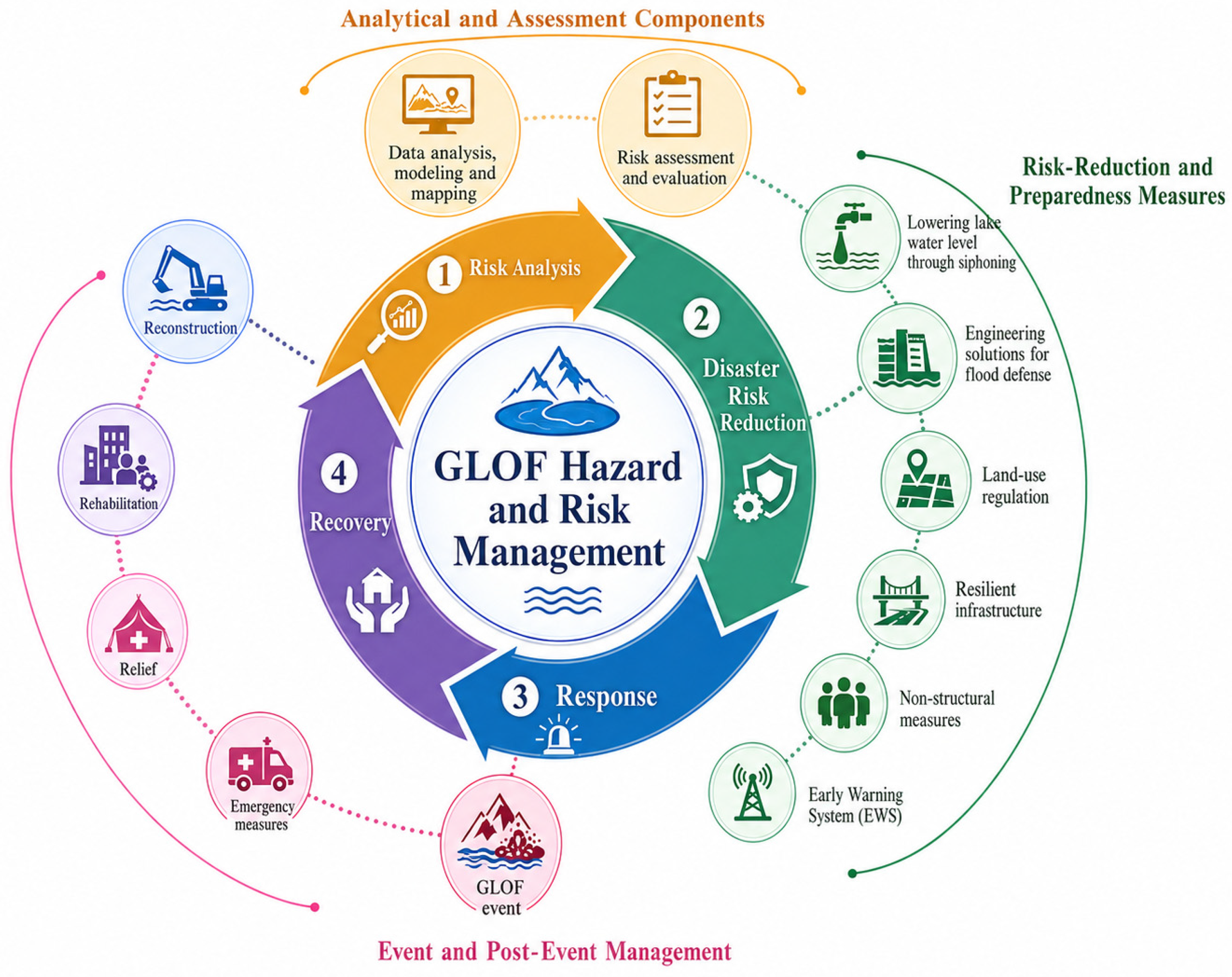
Effective GLOF risk reduction in HMA relies on combining hazard and risk mapping, early warning systems, and complementary structural and non-structural measures. Hazard-focused tools identify plausible outburst pathways, flow depths, velocities, and inundation extents, whereas risk-focused tools combine hazard information with exposure and vulnerability indicators to prioritize downstream communities, infrastructure, and assets where losses would be most likely or severe [34]. Because GLOFs are typically rapid-onset events with cascading process chains, successful strategies must balance targeted engineering at selected lakes with preparedness and governance across downstream corridors [98,104]. Figure 6 conceptualizes GLOF hazard and risk management as an iterative cycle linking risk analysis with disaster risk reduction, response, and recovery, and shows how structural and non-structural measures fit within this cycle.

5.2.1. Hazard and Risk Mapping

Hazard and risk mapping is a cornerstone of GLOF management because it links lake conditions to downstream flow pathways and identifies where damaging depths, velocities, and inundation footprints are plausible under defined scenarios [90,137,138]. In practice, mapping integrates remote sensing and DEM-based terrain analysis with empirical lake-volume/peak-discharge estimation and scenario-based hydrodynamic modelling to generate hazard layers representing plausible flood extents and intensities [139,140]. When hazard layers are combined with exposure and vulnerability information (population, critical infrastructure, access constraints), the result is a ranked basis for prioritizing lakes, corridors, and communities for monitoring, early warning systems deployment, or targeted interventions [122]. Because lakes and downstream assets change over time, mapping is most useful when it is updated iteratively and benchmarked against observations where possible [141].

5.2.2. Early Warning Systems

Early warning systems are a key strategy for reducing loss of life because they translate monitoring into timely alerts and actionable responses [104]. Effective systems integrate four interdependent components: risk knowledge, monitoring and forecasting, communication, and response capability [27,142]. Monitoring typically combines in situ sensors (e.g., lake level, outlet discharge, precipitation, ground motion) with repeat satellite observations to detect rapid lake and slope change where access is limited [5,43]. Communication and response depend on redundancy (sirens, radio, mobile networks, community messengers) and standard operating procedures that define alert levels and evacuation routes and are tested through drills [93,104,122]. The most common operational limitations are false alarms, power or telemetry outages, and maintenance constraints, which reinforces the need to embed early warning systems within local governance and sustained training rather than treating it as a standalone technical installation [143].

5.2.3. Structural and Non-Structural Measures

Structural interventions reduce hazard by modifying lake storage, stabilizing outlets, or strengthening vulnerable dam sections, and they are most effective when designed using site-specific field investigation and scenario modelling [27,95]. Common measures include controlled lake lowering (e.g., syphons, outlet excavation), engineered and armoured spillways, outlet-channel stabilization, and selective dam reinforcement where feasible [34]. Performance depends on dam material and ice content, lake geometry and inflow regime, valley confinement, site accessibility, and long-term operation and maintenance capacity [34,104]. Because no engineering solution eliminates residual hazard, structural works should be implemented alongside monitoring and early warning systems to ensure that reduced peak outflow translates into reduced losses [24].
Non-structural measures reduce losses by lowering exposure and strengthening response capacity without modifying the lake itself. Core elements include land-use planning and hazard zoning, risk communication and education, and preparedness planning that co-develops evacuation routes, shelters, and standard operating procedures with local communities [79]. These measures are most effective when institutionalized, regularly updated, and linked to drills so that alerts lead to timely action [104]. Persistent constraints include limited institutional capacity, communication gaps, and financial limitations that restrict long-term maintenance and equitable access to warnings and safe relocation [22]. Because many HMA rivers are transboundary, interoperable warning protocols, coordinated data sharing, and joint response planning are essential for managing downstream cascading consequences across borders [132]. The relevance of these issues is illustrated by two recent policy-relevant cases: the 2023 South Lhonak Lake GLOF in Sikkim and the 2025 Gyirong/Rasuwagadhi transboundary flood on the China–Nepal border (Box 1). These cases demonstrate that operational GLOF risk reduction in HMA requires a shift from static lake inventories toward multi-sensor monitoring of lake evolution, slope instability, dam conditions, downstream exposure, hydropower vulnerability, and transboundary communication pathways.
Box 1. Recent policy-relevant GLOF cases in HMA: South Lhonak 2023 and Gyirong/Rasuwagadhi 2025.
South Lhonak Lake, Sikkim, India, 3–4 October 2023: The South Lhonak Lake GLOF is one of the most consequential Himalayan GLOF disasters in recent years and provides a clear example of a cascading high-mountain hazard process. Recent event reconstructions indicate that the disaster involved slope or moraine instability above South Lhonak Lake, displacement-wave generation, rapid lake drainage, downstream flood and debris-flow propagation, sediment entrainment, and interaction with hydropower infrastructure [68,69,70]. The event caused major downstream destruction, including failure of the 1200 MW Teesta-III hydropower dam, and demonstrates that lake-growth monitoring alone is insufficient without slope-instability assessment, hydropower exposure mapping, process-chain modelling, real-time warning, and emergency-response planning.
Gyirong/Rasuwagadhi, China–Nepal border, July 2025: The July 2025 Gyirong/Rasuwagadhi transboundary flood illustrates a different but equally important risk pathway: rapid drainage of a supraglacial lake in a transboundary basin. Preliminary satellite-based assessments and media reports indicated that the flood originated from drainage of a supraglacial lake in Tibet, China, and propagated into Nepal’s Bhote Koshi/Rasuwagadhi corridor, causing fatalities, missing persons, damage to cross-border infrastructure, disruption of the Nepal–China trade corridor, and impacts to hydropower and transport systems [144,145,146]. Because some details of this event remain preliminary, it is treated here as a recent policy-relevant case rather than as a fully finalized database entry. Nevertheless, it highlights the urgent need for cross-border glacial-lake monitoring, rapid satellite-based event attribution, shared warning protocols, and coordinated disaster response in HMA transboundary river corridors.
Synthesis: Together, these two cases show that recent GLOF risk in HMA is increasingly shaped by compound and cascading processes rather than lake breaching alone. South Lhonak emphasizes the need to integrate slope-instability monitoring, hydropower exposure, and process-chain modelling into pre-event hazard assessment, while the Gyirong/Rasuwagadhi event highlights transboundary data-sharing and early-warning challenges. Both cases strengthen the argument that remote sensing should be used not only for periodic lake inventories but also for near-real-time monitoring, event reconstruction, exposure assessment, and operational risk reduction.

5.2.4. Integrated Implementation Framework

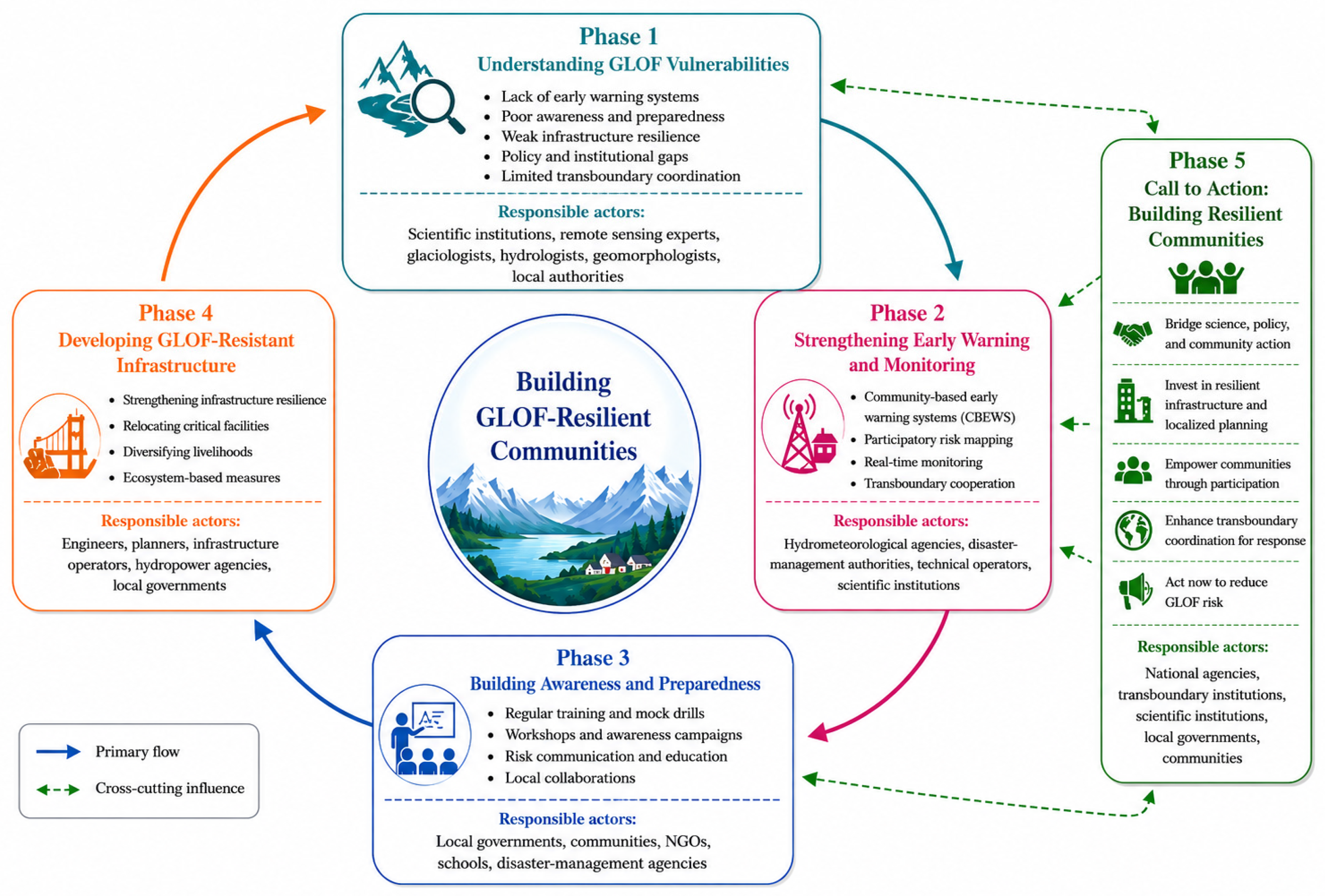
A coordinated approach is required to translate GLOF hazard assessment into durable risk reduction in HMA, combining mapping, monitoring, early warning system and structural interventions at prioritized lakes, and governance mechanisms that support sustained maintenance and preparedness [98]. Figure 6 conceptualizes GLOF hazard and risk management as an iterative cycle linking risk analysis with disaster risk reduction, response, and recovery, and it shows how structural and non-structural measures fit within this cycle. Figure 7 presents a five-phase pathway for building GLOF-resilient communities, moving from diagnosing vulnerabilities to strengthening monitoring and early warning, building awareness and preparedness, developing resilient infrastructure and planning, and sustaining coordinated action. Together, these frameworks highlight that effectiveness depends as much on sustained capacity and governance as on technical modelling and engineering design. The distinctive value of the proposed frameworks is that they translate the review evidence into an HMA-focused implementation pathway by linking remote-sensing-based monitoring, historical GLOF records, future lake-change assessment, uncertainty propagation, early warning, mitigation measures, governance coordination, and community resilience within a single operational cycle.
The phases shown in Figure 7 require different but coordinated responsibilities. Scientists, remote-sensing specialists, glaciologists, hydrologists, geomorphologists, and modelling experts are primarily responsible for generating and updating glacial-lake inventories, detecting lake and slope changes, modelling breach and flood scenarios, assessing uncertainty, and translating technical results into interpretable hazard and exposure products. Hydrometeorological agencies and disaster-management authorities are responsible for converting these products into warning thresholds, alert levels, standard operating procedures, and operational monitoring protocols. Local governments, infrastructure operators, NGOs, and community organizations are responsible for evacuation planning, preparedness drills, public communication, maintenance of warning infrastructure, and last-mile dissemination. Therefore, the transition from scientific knowledge to actionable risk reduction depends on sustained communication between researchers and authorities, including shared databases, co-produced hazard maps, agreed warning thresholds, periodic training, and feedback after drills or events.
Existing early-warning and mitigation examples show that technical systems alone are insufficient unless they are embedded in institutional and community response structures. In Nepal, Tsho Rolpa and Imja Tsho illustrate the role of lake lowering, monitoring, warning systems, and community preparedness in reducing potential downstream losses [63,64]. In Bhutan, the Punakha-Wangdue GLOF early-warning system demonstrates the importance of formal standard operating procedures, agency roles, sirens, communication chains, and preparedness planning [65]. Monitoring systems such as Cirenmaco in the Tibetan Plateau further illustrate how real-time sensors and defined warning thresholds can support downstream warning where maintenance capacity and communication pathways are reliable [66]. These examples indicate that effective GLOF early warning requires risk knowledge, monitoring and detection, communication of warnings, and response capacity [67].

6. Synthesis-Level Lessons and Future Research Priorities

6.1. Synthesis-Level Lessons from GLOF Research in HMA

Across HMA, the evidence reviewed in this paper shows that GLOF hazard is controlled by the coupled evolution of glacial lakes, dam stability, glacier dynamics, slope processes, hydroclimatic extremes, and downstream exposure. Five synthesis-level lessons emerge. First, historical GLOF records remain incomplete and unevenly documented across sub-regions, which limits robust inference about long-term frequency trends and trigger attribution. Second, methodological differences among lake inventories, minimum mapping thresholds, lake-volume equations, susceptibility indicators, DEM products, and hydrodynamic models can strongly influence hazard interpretation. Third, uncertainty propagates through the full assessment chain, from lake mapping and volume estimation to breach modelling, flood routing, exposure assessment, and risk prioritization. Fourth, recent events demonstrate that GLOFs often occur as part of compound and cascading process chains involving rainfall, slope failure, glacier instability, sediment entrainment, and infrastructure exposure. Fifth, remote-sensing products are most useful for risk reduction when they are linked to field validation, early warning, institutional coordination, and operational decision-making. These lessons provide the basis for the future research priorities outlined below.

6.2. Concrete Future Research Priorities for GLOF Assessment and Risk Reduction in HMA

6.2.1. Build Harmonized Multi-Temporal Lake Inventories for GLOF Applications

A first priority is to build consistent multi-temporal glacial-lake inventories for HMA that are explicitly designed for GLOF applications, using consistent mapping thresholds, glacier–lake proximity rules, and temporal coverage. These inventories should report lake type and glacier-contact state where possible, because these attributes directly affect GLOF susceptibility interpretation and scenario selection. Explicit quality control is needed for seasonal ice, shadows, debris influence, and cloud contamination, along with transparent version control so GLOF-relevant trends are comparable through time. Open reference datasets for training and validation are essential so automated mapping can scale without losing accuracy or temporal consistency. A unified inventory baseline would immediately improve the consistency of GLOF lake screening, hotspot identification, and multi-temporal monitoring across HMA.

6.2.2. Expand Targeted Field Observations of GLOF-Critical Parameters

A second priority is targeted field measurement of the parameters that most strongly control GLOF magnitude and model uncertainty, particularly lake bathymetry, outlet geometry and elevation, and dam composition including ice content and evidence of seepage or piping. Because field resources are limited, campaigns should focus on high-leverage lakes identified through screening and hotspot analyses, where improved constraints would most reduce uncertainty in breach development and peak outflow. Field datasets should be collected in a way that directly supports model calibration and benchmarking, including repeat measurements where feasible. Expanding calibration datasets for area–volume relations and dam properties will reduce systematic bias in regional GLOF scenario modelling and improve transferability across sub-regions.

6.2.3. Integrate Heatwaves and Compound Extremes into GLOF Hazard Assessment

A third priority is to treat warming-driven extremes explicitly, especially heatwaves and compound warm and wet periods, as both conditioning factors and potential initiators of GLOFs. Future studies should link extreme-temperature and intense-precipitation diagnostics to lake-level changes, snow and ice conditions, and slope-instability indicators, because these factors can elevate overtopping likelihood and breach potential over short timescales. This is necessary to stress-test GLOF early-warning thresholds, scenario design, and engineering assumptions under non-stationary extremes. Heatwave-aware monitoring and modelling will also help identify where GLOF hazard may increase disproportionately compared with background lake growth alone.

6.2.4. Standardize Uncertainty Propagation and Benchmarking of GLOF Models

A fourth priority is to propagate uncertainty consistently from lake mapping through volume estimation, breach generation, and routing, so GLOF hazard outputs are delivered as credible ranges rather than single-point estimates. In parallel, benchmarking datasets and minimum reporting standards are needed for comparing GLOF breach and routing models, including documentation of DEM resolution, roughness assumptions, breach parameterization, calibration evidence, and performance metrics. Where relevant, modelling should represent cascading GLOF process chains such as mass movement into lakes producing impulse waves and sediment-rich floods, because simplified representations can underestimate hazard in steep terrain. Consistent benchmarking will improve comparability across studies and increase confidence in decision-ready outputs.

6.2.5. Operationalize Early Warning, Risk Reduction, and Transboundary Coordination

A final priority is operationalization, ensuring that improved assessment products can be sustained through interoperable monitoring, warning, and response systems in remote and transboundary basins. Early warning must be designed around redundancy, maintenance feasibility, clear alert protocols, and regular drills that reliably convert warnings into action. Because many HMA rivers cross borders, compatible data standards, coordinated alerting, and joint response planning are essential to reduce downstream consequences beyond the source catchment. Strengthening institutional capacity and long-term funding models is therefore as important as technical advances for durable risk reduction. Together, these priorities translate the synthesis-level lessons into actionable research and operational needs for improving GLOF assessment, monitoring, and risk reduction across HMA.

7. Conclusions

GLOFs remain a major cryosphere-driven hazard in HMA, where glacier mass loss, changing hydroclimatic extremes, and evolving glacial-lake systems are reshaping high-mountain risk landscapes. This review provides an HMA-focused, remote-sensing-oriented synthesis of historical GLOF evidence, glacial-lake evolution, assessment methods, future hazard changes, uncertainty sources, and risk-reduction strategies. The reviewed evidence shows that reported GLOFs are strongly clustered by sub-region and lake–dam type, but historical records remain incomplete and affected by uneven documentation and attribution uncertainty.
The review further demonstrates that remote sensing has become central to GLOF assessment in HMA, supporting lake inventory generation, lake-level and storage monitoring, susceptibility screening, breach and hydrodynamic modelling, exposure mapping, and event reconstruction. However, the reliability of GLOF hazard and risk assessment depends on how uncertainties propagate through lake mapping, volume estimation, dam and slope characterization, model parameterization, and exposure analysis. Future GLOF hazard is expected to be shaped not only by glacial-lake expansion but also by lake–dam stability, triggering processes, compound extremes, slope instability, and downstream exposure.
Effective GLOF risk reduction in HMA therefore requires integrated systems that combine harmonized lake inventories, targeted field observations, multi-sensor monitoring, transparent uncertainty assessment, early warning, structural and non-structural measures, and transboundary coordination. By linking Earth-observation evidence with process understanding and operational risk-management needs, this review highlights a pathway toward more credible and actionable GLOF assessment under continued warming.

Supplementary Materials

The following supporting information can be downloaded at: https://www.mdpi.com/article/10.3390/rs18121883/s1.

Author Contributions

Conceptualization, A.T.; methodology, A.T.; validation, A.T., data curation, A.T.; visualization, A.T.; writing—original draft preparation, A.T.; Conceptualization, J.W.; writing—review and editing, J.W.; supervision, J.W.; project administration, J.W.; funding acquisition, J.W.; writing—review and editing, F.K.S.C. All authors have read and agreed to the published version of the manuscript.

Funding

This study was financially supported by the National Key Research and Development Program of China (No. 2025YFE0211500), the China–Pakistan Joint Research Centre on Earth Sciences, the Construction Project of China Knowledge Centre for Engineering Sciences and Technology (No. CKCEST-2023-1-5), and the CAS-ANSO scholarship for International Students.

Data Availability Statement

The data supporting the findings of this study are included within the article and its Supplementary Materials.

Acknowledgments

We thank the Institute of Geographic Sciences and Natural Resources Research, Chinese Academy of Sciences, for providing the platform to conduct this research. The authors used ChatGPT (version 5.2) solely to improve the English language, grammar, and readability of the manuscript. ChatGPT was not used to generate research content, ideas, data analysis, or conclusions. Figure 1 was prepared using Gemini (version 3.1 pro) software as a conceptual illustration. All scientific content, interpretations, and results are the authors’ own work.

Conflicts of Interest

The authors declare no conflicts of interest.

References

  1. Zheng, G.; Allen, S.K.; Bao, A.; Ballesteros-Cánovas, J.A.; Huss, M.; Zhang, G.; Li, J.; Yuan, Y.; Jiang, L.; Yu, T. Increasing risk of glacial lake outburst floods from future Third Pole deglaciation. Nat. Clim. Change 2021, 11, 411–417. [Google Scholar] [CrossRef]
  2. Lützow, N.; Veh, G.; Korup, O. A global database of historic glacier lake outburst floods. Earth Syst. Sci. Data 2023, 15, 2983–3000. [Google Scholar] [CrossRef]
  3. Zhang, G.; Carrivick, J.L.; Emmer, A.; Shugar, D.H.; Veh, G.; Wang, X.; Labedz, C.; Mergili, M.; Mölg, N.; Huss, M. Characteristics and changes of glacial lakes and outburst floods. Nat. Rev. Earth Environ. 2024, 5, 447–462. [Google Scholar] [CrossRef]
  4. Hugonnet, R.; McNabb, R.; Berthier, E.; Menounos, B.; Nuth, C.; Girod, L.; Farinotti, D.; Huss, M.; Dussaillant, I.; Brun, F.; et al. Accelerated global glacier mass loss in the early twenty-first century. Nature 2021, 592, 726–731. [Google Scholar] [CrossRef]
  5. Shugar, D.H.; Burr, A.; Haritashya, U.K.; Kargel, J.S.; Watson, C.S.; Kennedy, M.C.; Bevington, A.R.; Betts, R.A.; Harrison, S.; Strattman, K. Rapid worldwide growth of glacial lakes since 1990. Nat. Clim. Change 2020, 10, 939–945. [Google Scholar] [CrossRef]
  6. Wang, X.; Guo, X.; Yang, C.; Liu, Q.; Wei, J.; Zhang, Y.; Liu, S.; Zhang, Y.; Jiang, Z.; Tang, Z. Glacial lake inventory of High Mountain Asia in 1990 and 2018 derived from Landsat images. Earth Syst. Sci. Data 2020, 12, 2169–2182. [Google Scholar] [CrossRef]
  7. Sattar, A.; Goswami, A.; Kulkarni, A.V. Hydrodynamic moraine-breach modeling and outburst flood routing-A hazard assessment of the South Lhonak lake, Sikkim. Sci. Total Environ. 2019, 668, 362–378. [Google Scholar] [CrossRef] [PubMed]
  8. Jain, S.K.; Jain, S.K.; Ahmed, R. Glacial lake outburst floods (GLOFs): Causes, modeling, and mitigation in Indian Himalayan region. GeoJournal 2025, 90, 85. [Google Scholar] [CrossRef]
  9. Emmer, A. Glacier retreat and glacial lake outburst floods (GLOFs). In Oxford Research Encyclopedia of Natural Hazard Science; Oxford University Press: Oxford, UK, 2017. [Google Scholar]
  10. Huggel, C.; Haeberli, W.; Kääb, A.; Bieri, D.; Richardson, S. An assessment procedure for glacial hazards in the Swiss Alps. Can. Geotech. J. 2004, 41, 1068–1083. [Google Scholar] [CrossRef]
  11. Veh, G.; Lützow, N.; Kharlamova, V.; Petrakov, D.; Hugonnet, R.; Korup, O. Trends, breaks, and biases in the frequency of reported glacier lake outburst floods. Earth’s Future 2022, 10, e2021EF002426. [Google Scholar] [CrossRef]
  12. Tang, M.; Xu, Q.; Wang, L.; Zhao, H.; Wu, G.; Zhou, J.; Li, G.; Cai, W.; Chen, X. Hidden dangers of ice avalanches and glacier lake outburst floods on the Tibetan Plateau: Identification, inventory, and distribution. Landslides 2023, 20, 2563–2581. [Google Scholar] [CrossRef]
  13. Yang, L.; Lu, Z.; Zhao, C.; Kim, J.; Yang, C.; Wang, B.; Liu, X.; Wang, Z. Analyzing the triggering factors of glacial lake outburst floods with SAR and optical images: A case study in Jinweng Co, Tibet, China. Landslides 2022, 19, 855–864. [Google Scholar] [CrossRef]
  14. Muñoz, R.; Vaghefi, S.; Drenkhan, F.; Santos, M.; Viviroli, D.; Muccione, V.; Huggel, C. Assessing water management strategies in data-scarce mountain regions under uncertain climate and socio-economic changes. Water Resour. Manag. 2024, 38, 4083–4100. [Google Scholar] [CrossRef]
  15. Zhang, G.; Yao, T.; Xie, H.; Wang, W.; Yang, W. An inventory of glacial lakes in the Third Pole region and their changes in response to global warming. Glob. Planet. Change 2015, 131, 148–157. [Google Scholar] [CrossRef]
  16. Zhang, M.; Chen, F.; Guo, H.; Yi, L.; Zeng, J.; Li, B. Glacial lake area changes in high mountain Asia during 1990–2020 using satellite remote sensing. Research 2022, 2022, 9821275. [Google Scholar] [CrossRef]
  17. Nie, Y.; Sheng, Y.; Liu, Q.; Liu, L.; Liu, S.; Zhang, Y.; Song, C. A regional-scale assessment of Himalayan glacial lake changes using satellite observations from 1990 to 2015. Remote Sens. Environ. 2017, 189, 1–13. [Google Scholar] [CrossRef]
  18. Khadka, N.; Zhang, G.; Thakuri, S. Glacial lakes in the Nepal Himalaya: Inventory and decadal dynamics (1977–2017). Remote Sens. 2018, 10, 1913. [Google Scholar] [CrossRef]
  19. Prakash, C.; Nagarajan, R. Glacial lake inventory and evolution in northwestern Indian Himalaya. IEEE J. Sel. Top. Appl. Earth Obs. Remote Sens. 2017, 10, 5284–5294. [Google Scholar] [CrossRef]
  20. Chen, F.; Zhang, M.; Guo, H.; Allen, S.; Kargel, J.S.; Haritashya, U.K.; Watson, C.S. Annual 30 m dataset for glacial lakes in High Mountain Asia from 2008 to 2017. Earth Syst. Sci. Data 2021, 13, 741–766. [Google Scholar] [CrossRef]
  21. Zheng, G.; Bao, A.; Allen, S.; Ballesteros-Cánovas, J.A.; Yuan, Y.; Jiapaer, G.; Stoffel, M. Numerous unreported glacial lake outburst floods in the Third Pole revealed by high-resolution satellite data and geomorphological evidence. Sci. Bull. 2021, 66, 1270–1273. [Google Scholar] [CrossRef]
  22. Taylor, C.; Robinson, T.R.; Dunning, S.; Rachel Carr, J.; Westoby, M. Glacial lake outburst floods threaten millions globally. Nat. Commun. 2023, 14, 487. [Google Scholar] [CrossRef] [PubMed]
  23. Furian, W.; Maussion, F.; Schneider, C. Projected 21st-century glacial lake evolution in High Mountain Asia. Front. Earth Sci. 2022, 10, 821798. [Google Scholar] [CrossRef]
  24. Ahmed, R.; Wani, G.F.; Ahmad, S.T.; Sahana, M.; Singh, H.; Ahmed, P. A review of glacial lake expansion and associated glacial lake outburst floods in the Himalayan region. Earth Syst. Environ. 2021, 5, 695–708. [Google Scholar] [CrossRef]
  25. Mir, R.A.; Jain, S.K.; Lohani, A.; Ahmed, R.; Ahmad, S.T.; Wani, G.F. Application of mike 11 for one-dimensional GLOF modeling of a rapidly expanding dalung proglacial lake, indus river basin, Western Himalaya. In Challenges of Disasters in Asia: Vulnerability, Adaptation and Resilience; Springer: Singapore, 2022; pp. 147–161. [Google Scholar]
  26. Mool, P.K.; Bajracharya, S.R.; Joshi, S.P. Inventory of Glaciers, Glacial Lakes and Glacial Lake Outburst Floods: Monitoring and Early Warning Systems in the Hindu Kush Himalayan Region Nepal; International Centre for Integrated Mountain Development (ICIMOD): Kathmandu, Nepal, 2001. [Google Scholar]
  27. Ahmed, R. Glacial Lake Outburst Flood (GLOF) Hazard and Risk Management Strategies: A Global Overview: R. Ahmed. Water Resour. Manag. 2025, 39, 1–16. [Google Scholar] [CrossRef]
  28. Nurakynov, S.; Sydyk, N.; Baygurin, Z.; Balakay, L. Advancements in Remote Sensing for Monitoring and Risk Assessment of Glacial Lake Outburst Floods. Geosciences 2025, 15, 211. [Google Scholar] [CrossRef]
  29. Shah, S.; Ishtiaque, A. Adaptation to glacial lake outburst floods (GLOFs) in the Hindukush-Himalaya: A review. Climate 2025, 13, 60. [Google Scholar] [CrossRef]
  30. Bazai, N.A.; Cui, P.; Carling, P.A.; Wang, H.; Hassan, J.; Liu, D.; Zhang, G.; Jin, W. Increasing glacial lake outburst flood hazard in response to surge glaciers in the Karakoram. Earth-Sci. Rev. 2021, 212, 103432. [Google Scholar] [CrossRef]
  31. Yao, X.; Liu, S.; Sun, M.; Wei, J.; Guo, W. Volume calculation and analysis of the changes in moraine-dammed lakes in the north Himalaya: A case study of Longbasaba lake. J. Glaciol. 2012, 58, 753–760. [Google Scholar] [CrossRef]
  32. Immerzeel, W.W.; Lutz, A.F.; Andrade, M.; Bahl, A.; Biemans, H.; Bolch, T.; Hyde, S.; Brumby, S.; Davies, B.J.; Elmore, A.C.; et al. Importance and vulnerability of the world’s water towers. Nature 2020, 577, 364–369. [Google Scholar] [CrossRef]
  33. Carrivick, J.L.; Tweed, F.S. A global assessment of the societal impacts of glacier outburst floods. Glob. Planet. Change 2016, 144, 1–16. [Google Scholar] [CrossRef]
  34. Haeberli, W.; Butler, M.; Huggel, C.; Lehmann Friedli, T.; Schaub, Y.; Schleiss, A.J. New lakes in deglaciating high-mountain regions–opportunities and risks. Clim. Change 2016, 139, 201–214. [Google Scholar] [CrossRef]
  35. RGI Consortium. Randolph Glacier Inventory—A Dataset of Global Glacier Outlines, Version 7.0; National Snow and Ice Data Center: Boulder, CO, USA, 2023. [Google Scholar] [CrossRef]
  36. Brun, F.; Berthier, E.; Wagnon, P.; Kääb, A.; Treichler, D. A spatially resolved estimate of High Mountain Asia glacier mass balances from 2000 to 2016. Nat. Geosci. 2017, 10, 668–673. [Google Scholar] [CrossRef]
  37. Guillet, G.; King, O.; Lv, M.; Ghuffar, S.; Benn, D.; Quincey, D.; Bolch, T. A regionally resolved inventory of High Mountain Asia surge-type glaciers, derived from a multi-factor remote sensing approach. Cryosphere 2022, 16, 603–623. [Google Scholar] [CrossRef]
  38. Flores, J.A.; Gleason, C.J.; Brinkerhoff, C.B.; Harlan, M.E.; Lummus, M.M.; Stearns, L.A.; Feng, D. Mapping proglacial headwater streams in High Mountain Asia using PlanetScope imagery. Remote Sens. Environ. 2024, 306, 114124. [Google Scholar] [CrossRef]
  39. Schiemann, R.; Luthi, D.; Schär, C. Seasonality and interannual variability of the westerly jet in the Tibetan Plateau region. J. Clim. 2009, 22, 2940–2957. [Google Scholar] [CrossRef]
  40. Maussion, F.; Scherer, D.; Mölg, T.; Collier, E.; Curio, J.; Finkelnburg, R. Precipitation seasonality and variability over the Tibetan Plateau as resolved by the High Asia Reanalysis. J. Clim. 2014, 27, 1910–1927. [Google Scholar] [CrossRef]
  41. Kuang, X.; Jiao, J.J. Review on climate change on the Tibetan Plateau during the last half century. J. Geophys. Res. Atmos. 2016, 121, 3979–4007. [Google Scholar] [CrossRef]
  42. Shugar, D.H.; Jacquemart, M.; Shean, D.; Bhushan, S.; Upadhyay, K.; Sattar, A.; Schwanghart, W.; McBride, S.; De Vries, M.V.W.; Mergili, M. A massive rock and ice avalanche caused the 2021 disaster at Chamoli, Indian Himalaya. Science 2021, 373, 300–306. [Google Scholar] [CrossRef]
  43. Veh, G.; Korup, O.; Walz, A. Hazard from Himalayan glacier lake outburst floods. Proc. Natl. Acad. Sci. USA 2020, 117, 907–912. [Google Scholar] [CrossRef]
  44. McFeeters, S.K. The use of the Normalized Difference Water Index (NDWI) in the delineation of open water features. Int. J. Remote Sens. 1996, 17, 1425–1432. [Google Scholar] [CrossRef]
  45. Gorelick, N.; Hancher, M.; Dixon, M.; Ilyushchenko, S.; Thau, D.; Moore, R. Google Earth Engine: Planetary-scale geospatial analysis for everyone. Remote Sens. Environ. 2017, 202, 18–27. [Google Scholar] [CrossRef]
  46. Allen, S.K.; Zhang, G.; Wang, W.; Yao, T.; Bolch, T. Potentially dangerous glacial lakes across the Tibetan Plateau revealed using a large-scale automated assessment approach. Sci. Bull. 2019, 64, 435–445. [Google Scholar] [CrossRef]
  47. Huggel, C.; Cochachin, A.; Drenkhan, F.; Fluixá-Sanmartín, J.; Frey, H.; García Hernández, J.; Jurt, C.; Muñoz, R.; Price, K.; Vicuña, L. Glacier Lake 513, Peru: Lessons for early warning service development. WMO Bull. 2020, 69, 45–52. [Google Scholar]
  48. Kaushik, S.; Singh, T.; Joshi, P.K.; Dietz, A.J. Automated mapping of glacial lakes using multisource remote sensing data and deep convolutional neural network. Int. J. Appl. Earth Obs. Geoinf. 2022, 115, 103085. [Google Scholar] [CrossRef]
  49. Wilson, R.; Glasser, N.F.; Reynolds, J.M.; Harrison, S.; Anacona, P.I.; Schaefer, M.; Shannon, S. Glacial lakes of the Central and Patagonian Andes. Glob. Planet. Change 2018, 162, 275–291. [Google Scholar] [CrossRef]
  50. Wulder, M.A.; Roy, D.P.; Radeloff, V.C.; Loveland, T.R.; Anderson, M.C.; Johnson, D.M.; Healey, S.; Zhu, Z.; Scambos, T.A.; Pahlevan, N. Fifty years of Landsat science and impacts. Remote Sens. Environ. 2022, 280, 113195. [Google Scholar] [CrossRef]
  51. Wangchuk, S.; Bolch, T.; Zawadzki, J. Towards automated mapping and monitoring of potentially dangerous glacial lakes in Bhutan Himalaya using Sentinel-1 Synthetic Aperture Radar data. Int. J. Remote Sens. 2019, 40, 4642–4667. [Google Scholar] [CrossRef]
  52. Taylor, L.S.; Quincey, D.J.; Smith, M.W.; Baumhoer, C.A.; McMillan, M.; Mansell, D.T. Remote sensing of the mountain cryosphere: Current capabilities and future opportunities for research. Prog. Phys. Geogr. Earth Environ. 2021, 45, 931–964. [Google Scholar] [CrossRef]
  53. Maharjan, S.B.; Mool, P.K.; Lizong, W.; Xiao, G.; Shrestha, F.; Shrestha, R.B.; Khanal, N.R.; Bajracharya, S.R.; Joshi, S.; Shai, S.; et al. The Status of Glacial Lakes in the Hindu Kush Himalaya; ICIMOD Research Report 2018/1; International Centre for Integrated Mountain Development (ICIMOD): Kathmandu, Nepal, 2018. [Google Scholar]
  54. Shugar, D.; Burr, A.; Haritashya, U.; Kargel, J.; Watson, C.; Kennedy, M.; Bevington, A.; Betts, R.; Harrison, S.; Strattman, K. High Mountain Asia Near-Global Multi-Decadal Glacial Lake Inventory. In NASA National Snow and Ice Data Center Distributed Active Archive Center (DAAC) Data Set; NASA National Snow and Ice Data Center Distributed Active Archive Center: Boulder, CO, USA, 2020. [Google Scholar] [CrossRef]
  55. Shrestha, F.; Steiner, J.F.; Shrestha, R.; Dhungel, Y.; Joshi, S.P.; Inglis, S.; Ashraf, A.; Wali, S.; Walizada, K.M.; Zhang, T. A comprehensive and version-controlled database of glacial lake outburst floods in High Mountain Asia. Earth Syst. Sci. Data 2023, 15, 3941–3961. [Google Scholar] [CrossRef]
  56. ICIMOD. GLOF Database of High Mountain Asia. Available online: https://rds.icimod.org/metadata/8881454b-6f7c-461b-95c2-eaf7618230d9 (accessed on 5 March 2026).
  57. GLIMS Consortium. GLIMS Glacier Database, Version 1; National Snow and Ice Data Center: Boulder, CO, USA, 2026. [Google Scholar] [CrossRef]
  58. RGI Consortium. Randolph Glacier Inventory—A Dataset of Global Glacier Outlines, Version 6.0; National Snow and Ice Data Center: Boulder, CO, USA, 2017. [Google Scholar] [CrossRef]
  59. Han, X.; Zhang, G.; Wang, J.; Tseng, K.-H.; Li, J.; Woolway, R.I.; Shum, C.; Xu, F. Reconstructing Tibetan Plateau lake bathymetry using ICESat-2 photon-counting laser altimetry. Remote Sens. Environ. 2024, 315, 114458. [Google Scholar] [CrossRef]
  60. He, H.; Chen, J.; Sheng, H.; Lhakpa, D.; Sun, K.; Duan, Z. Mapping bathymetry on Tibetan Plateau lakes using ICESat-2 laser altimetry. Int. J. Remote Sens. 2025, 46, 4193–4214. [Google Scholar] [CrossRef]
  61. Biancamaria, S.; Lettenmaier, D.P.; Pavelsky, T.M. The SWOT mission and its capabilities for land hydrology. In Remote Sensing and Water Resources; Cazenave, A.C., Champollion, N., Benveniste, J., Chen, J., Eds.; Space Sciences Series of ISSI; Springer: Berlin/Heidelberg, Germany, 2016; Volume 55, pp. 117–147. [Google Scholar]
  62. Morrow, R.; Fu, L.-L.; Ardhuin, F.; Benkiran, M.; Chapron, B.; Cosme, E.; d’Ovidio, F.; Farrar, J.T.; Gille, S.T.; Lapeyre, G. Global observations of fine-scale ocean surface topography with the surface water and ocean topography (SWOT) mission. Front. Mar. Sci. 2019, 6, 232. [Google Scholar] [CrossRef]
  63. Round, V.; Leinss, S.; Huss, M.; Haemmig, C.; Hajnsek, I. Surge dynamics and lake outbursts of Kyagar Glacier, Karakoram. Cryosphere 2017, 11, 723–739. [Google Scholar] [CrossRef]
  64. Li, G.; Lv, M.; Quincey, D.J.; Taylor, L.S.; Li, X.; Yan, S.; Sun, Y.; Guo, H. Characterizing the surge behaviour and associated ice-dammed lake evolution of the Kyagar Glacier in the Karakoram. Cryosphere 2023, 17, 2891–2907. [Google Scholar] [CrossRef]
  65. Zhang, Z.; Zhao, J.; Liu, S.; Zhang, Q.; Jiang, Z.; Xu, Y.; Su, H. Characterization of three surges of the kyagar glacier, karakoram. Remote Sens. 2023, 15, 2113. [Google Scholar] [CrossRef]
  66. Bhambri, R.; Watson, C.S.; Hewitt, K.; Haritashya, U.K.; Kargel, J.S.; Pratap Shahi, A.; Chand, P.; Kumar, A.; Verma, A.; Govil, H. The hazardous 2017–2019 surge and river damming by Shispare Glacier, Karakoram. Sci. Rep. 2020, 10, 4685. [Google Scholar] [CrossRef]
  67. Rashid, I.; Majeed, U.; Jan, A.; Glasser, N.F. The January 2018 to September 2019 surge of Shisper Glacier, Pakistan, detected from remote sensing observations. Geomorphology 2020, 351, 106957. [Google Scholar] [CrossRef]
  68. Yu, Y.; Li, B.; Li, Y.; Jiang, W. Retrospective analysis of glacial lake outburst flood (GLOF) using AI Earth InSAR and optical images: A case study of South Lhonak Lake, Sikkim. Remote Sens. 2024, 16, 2307. [Google Scholar] [CrossRef]
  69. Sattar, A.; Cook, K.L.; Rai, S.K.; Berthier, E.; Allen, S.; Rinzin, S.; de Vries, M.V.W.; Haeberli, W.; Kushwaha, P.; Shugar, D.H. The Sikkim flood of October 2023: Drivers, causes, and impacts of a multihazard cascade. Science 2025, 387, eads2659. [Google Scholar] [CrossRef]
  70. Qu, G.; Li, S.; Li, C.; Yu, W.; Shan, Y.; Li, Z.; Li, W. Comprehensive analysis of the catastrophic October 4th 2023 glacial lake outburst flood in the South Lhonak Lake, Sikkim Himalayas. J. Hydrol. Reg. Stud. 2025, 60, 102578. [Google Scholar] [CrossRef]
  71. Gao, Y.; Wang, J.; Liu, S.; Yao, X.; Qi, M.; Liang, P.; Xie, F.; Mu, J.; Ma, X. Monitoring dynamics of Kyagar Glacier surge and repeated draining of Ice-dammed lake using multi-source remote sensing. Sci. Total Environ. 2024, 928, 172467. [Google Scholar] [CrossRef]
  72. Lovell, H.; Muhammad, S. Multiple phases of ice-dammed lake formation and drainage associated with a surge of Shisper Glacier, western Karakoram. J. Glaciol. 2025, 71, e10. [Google Scholar] [CrossRef]
  73. Zhang, G.; Chen, W.; Xie, H. Tibetan Plateau’s lake level and volume changes from NASA’s ICESat/ICESat-2 and Landsat Missions. Geophys. Res. Lett. 2019, 46, 13107–13118. [Google Scholar] [CrossRef]
  74. Fu, L.-L.; Pavelsky, T.; Cretaux, J.-F.; Morrow, R.; Farrar, J.T.; Vaze, P.; Sengenes, P.; Vinogradova-Shiffer, N.; Sylvestre-Baron, A.; Picot, N. The surface water and ocean topography mission: A breakthrough in radar remote sensing of the ocean and land surface water. Geophys. Res. Lett. 2024, 51, e2023GL107652. [Google Scholar] [CrossRef]
  75. Jet Propulsion Laboratory. Surface Water and Ocean Topography (SWOT) Mission Overview. Available online: https://swot.jpl.nasa.gov/mission/overview/ (accessed on 5 March 2026).
  76. Haritashya, U.K.; Kargel, J.S.; Shugar, D.H.; Leonard, G.J.; Strattman, K.; Watson, C.S.; Shean, D.; Harrison, S.; Mandli, K.T.; Regmi, D. Evolution and controls of large glacial lakes in the Nepal Himalaya. Remote Sens. 2018, 10, 798. [Google Scholar] [CrossRef]
  77. Cook, K.L.; Andermann, C.; Gimbert, F.; Adhikari, B.R.; Hovius, N. Glacial lake outburst floods as drivers of fluvial erosion in the Himalaya. Science 2018, 362, 53–57. [Google Scholar] [CrossRef]
  78. Cook, S.; Quincey, D. Estimating the volume of Alpine glacial lakes. Earth Surf. Dyn. 2015, 3, 559–575. [Google Scholar] [CrossRef]
  79. Rounce, D.R.; McKinney, D.C.; Lala, J.M.; Byers, A.C.; Watson, C.S. A new remote hazard and risk assessment framework for glacial lakes in the Nepal Himalaya. Hydrol. Earth Syst. Sci. 2016, 20, 3455–3475. [Google Scholar] [CrossRef]
  80. Qi, M.; Liu, S.; Wu, K.; Zhu, Y.; Xie, F.; Jin, H.; Gao, Y.; Yao, X. Improving the accuracy of glacial lake volume estimation: A case study in the Poiqu basin, central Himalayas. J. Hydrol. 2022, 610, 127973. [Google Scholar] [CrossRef]
  81. Patel, L.K.; Sharma, P.; Laluraj, C.; Thamban, M.; Singh, A.; Ravindra, R. A geospatial analysis of Samudra Tapu and Gepang Gath glacial lakes in the Chandra Basin, Western Himalaya. Nat. Hazards 2017, 86, 1275–1290. [Google Scholar] [CrossRef]
  82. Clague, J.J.; Mathews, W.H. The magnitude of jökulhlaups. J. Glaciol. 1973, 12, 501–504. [Google Scholar] [CrossRef]
  83. Walder, J.S.; Costa, J.E. Outburst floods from glacier-dammed lakes: The effect of mode of lake drainage on flood magnitude. Earth Surf. Process. Landf. 1996, 21, 701–723. [Google Scholar] [CrossRef]
  84. Emmer, A.; Vilímek, V. Lake and breach hazard assessment for moraine-dammed lakes: An example from the Cordillera Blanca (Peru). Nat. Hazards Earth Syst. Sci. 2013, 13, 1551–1565. [Google Scholar] [CrossRef]
  85. Carrivick, J.L.; Tweed, F.S.; Ng, F.; Quincey, D.J.; Mallalieu, J.; Ingeman-Nielsen, T.; Mikkelsen, A.B.; Palmer, S.J.; Yde, J.C.; Homer, R. Ice-dammed lake drainage evolution at Russell Glacier, West Greenland. Front. Earth Sci. 2017, 5, 100. [Google Scholar] [CrossRef]
  86. Dykes, R.; Brook, M.; Robertson, C.; Fuller, I. Twenty-first century calving retreat of Tasman glacier, Southern Alps, New Zealand. Arct. Antarct. Alp. Res. 2011, 43, 1–10. [Google Scholar] [CrossRef]
  87. Zhang, G.; Bolch, T.; Yao, T.; Rounce, D.R.; Chen, W.; Veh, G.; King, O.; Allen, S.K.; Wang, M.; Wang, W. Underestimated mass loss from lake-terminating glaciers in the greater Himalaya. Nat. Geosci. 2023, 16, 333–338. [Google Scholar] [CrossRef]
  88. Wang, X.; Liu, S.; Ding, Y.; Guo, W.; Jiang, Z.; Lin, J.; Han, Y. An approach for estimating the breach probabilities of moraine-dammed lakes in the Chinese Himalayas using remote-sensing data. Nat. Hazards Earth Syst. Sci. 2012, 12, 3109–3122. [Google Scholar] [CrossRef]
  89. Sharma, R.; Pradhan, P.; Sharma, N.; Shrestha, D. Remote sensing and in situ-based assessment of rapidly growing South Lhonak glacial lake in eastern Himalaya, India. Nat. Hazards 2018, 93, 393–409. [Google Scholar] [CrossRef]
  90. Khanal, N.R.; Hu, J.-M.; Mool, P. Glacial lake outburst flood risk in the Poiqu/Bhote Koshi/Sun Koshi river basin in the Central Himalayas. Mt. Res. Dev. 2015, 35, 351–364. [Google Scholar] [CrossRef]
  91. Sakai, A. Glacial lakes in the Himalayas: A review on formation and expansion processes. Glob. Environ. Res. 2012, 16, 23–30. [Google Scholar] [CrossRef]
  92. Wang, S.-j.; Zhang, T. Glacial lakes change and current status in the central Chinese Himalayas from 1990 to 2010. J. Appl. Remote Sens. 2013, 7, 073459. [Google Scholar] [CrossRef]
  93. Allen, S.K.; Linsbauer, A.; Randhawa, S.; Huggel, C.; Rana, P.; Kumari, A. Glacial lake outburst flood risk in Himachal Pradesh, India: An integrative and anticipatory approach considering current and future threats. Nat. Hazards 2016, 84, 1741–1763. [Google Scholar] [CrossRef]
  94. Westoby, M.J.; Glasser, N.F.; Brasington, J.; Hambrey, M.J.; Quincey, D.J.; Reynolds, J.M. Modelling outburst floods from moraine-dammed glacial lakes. Earth-Sci. Rev. 2014, 134, 137–159. [Google Scholar] [CrossRef]
  95. Richardson, S.D.; Reynolds, J.M. An overview of glacial hazards in the Himalayas. Quat. Int. 2000, 65, 31–47. [Google Scholar] [CrossRef]
  96. Clague, J.J.; Evans, S.G. A review of catastrophic drainage of moraine-dammed lakes in British Columbia. Quat. Sci. Rev. 2000, 19, 1763–1783. [Google Scholar] [CrossRef]
  97. Kougkoulos, I.; Cook, S.J.; Jomelli, V.; Clarke, L.; Symeonakis, E.; Dortch, J.M.; Edwards, L.A.; Merad, M. Use of multi-criteria decision analysis to identify potentially dangerous glacial lakes. Sci. Total Environ. 2018, 621, 1453–1466. [Google Scholar] [CrossRef]
  98. Mergili, M.; Pudasaini, S.P.; Emmer, A.; Fischer, J.-T.; Cochachin, A.; Frey, H. Reconstruction of the 1941 GLOF process chain at lake Palcacocha (Cordillera Blanca, Peru). Hydrol. Earth Syst. Sci. 2020, 24, 93–114. [Google Scholar] [CrossRef]
  99. Wang, X.; Tolksdorf, V.; Otto, M.; Scherer, D. WRF-based dynamical downscaling of ERA5 reanalysis data for High Mountain Asia: Towards a new version of the High Asia Refined analysis. Int. J. Climatol. 2021, 41, 743–762. [Google Scholar] [CrossRef]
  100. Schneider, D.; Huggel, C.; Cochachin, A.; Guillén, S.; García, J. Mapping hazards from glacier lake outburst floods based on modelling of process cascades at Lake 513, Carhuaz, Peru. Adv. Geosci. 2014, 35, 145–155. [Google Scholar] [CrossRef]
  101. Sattar, A.; Goswami, A.; Kulkarni, A.V.; Emmer, A.; Haritashya, U.K.; Allen, S.; Frey, H.; Huggel, C. Future glacial lake outburst flood (GLOF) hazard of the South Lhonak Lake, Sikkim Himalaya. Geomorphology 2021, 388, 107783. [Google Scholar] [CrossRef]
  102. Allen, S.; Frey, H.; Haeberli, W.; Huggel, C.; Chiarle, M.; Geertsema, M. Assessment Principles for Glacier and Permafrost Hazards in Mountain Regions. In Oxford Research Encyclopedia of Natural Hazard Science; Oxford University Press: Oxford, UK, 2022; Available online: https://oxfordre.com/naturalhazardscience/display/10.1093/acrefore/9780199389407.001.0001/acrefore-9780199389407-e-356 (accessed on 2 June 2026).
  103. Wang, W.; Gao, Y.; Anacona, P.I.; Lei, Y.; Xiang, Y.; Zhang, G.; Li, S.; Lu, A. Integrated hazard assessment of Cirenmaco glacial lake in Zhangzangbo valley, Central Himalayas. Geomorphology 2018, 306, 292–305. [Google Scholar] [CrossRef]
  104. Worni, R.; Huggel, C.; Clague, J.J.; Schaub, Y.; Stoffel, M. Coupling glacial lake impact, dam breach, and flood processes: A modeling perspective. Geomorphology 2014, 224, 161–176. [Google Scholar] [CrossRef]
  105. Lala, J.M.; Rounce, D.R.; McKinney, D.C. Modeling the glacial lake outburst flood process chain in the Nepal Himalaya: Reassessing Imja Tsho’s hazard. Hydrol. Earth Syst. Sci. 2018, 22, 3721–3737. [Google Scholar] [CrossRef]
  106. Ali, M. Assessing climate-driven impacts on Karakoram glacier surge: A geospatial analysis highlighting Shishper Glacial Lake outburst flood events (2019–2022) as prime example. Heliyon 2024, 10, e35951. [Google Scholar] [CrossRef]
  107. Mergili, M.; Schneider, J. Regional-scale analysis of lake outburst hazards in the southwestern Pamir, Tajikistan, based on remote sensing and GIS. Nat. Hazards Earth Syst. Sci. 2011, 11, 1447–1462. [Google Scholar] [CrossRef]
  108. Zheng, G.; Mergili, M.; Emmer, A.; Allen, S.; Bao, A.; Guo, H.; Stoffel, M. The 2020 glacial lake outburst flood at Jinwuco, Tibet: Causes, impacts, and implications for hazard and risk assessment. Cryosphere 2021, 15, 3159–3180. [Google Scholar] [CrossRef]
  109. Bajracharya, B.; Shrestha, A.B.; Rajbhandari, L. Glacial lake outburst floods in the Sagarmatha region. Mt. Res. Dev. 2007, 27, 336–344. [Google Scholar] [CrossRef]
  110. Maskey, S.; Kayastha, R.B.; Kayastha, R. Glacial lakes outburst floods (GLOFs) modelling of Thulagi and lower Barun glacial lakes of Nepalese Himalaya. Prog. Disaster Sci. 2020, 7, 100106. [Google Scholar] [CrossRef]
  111. Westoby, M.J.; Brasington, J.; Glasser, N.; Hambrey, M.; Reynolds, J.M.; Hassan, M.A.; Lowe, A. Numerical modelling of glacial lake outburst floods using physically based dam-breach models. Earth Surf. Dyn. 2015, 3, 171–199. [Google Scholar] [CrossRef]
  112. Nie, Y.; Liu, W.; Liu, Q.; Hu, X.; Westoby, M.J. Reconstructing the Chongbaxia Tsho glacial lake outburst flood in the Eastern Himalaya: Evolution, process and impacts. Geomorphology 2020, 370, 107393. [Google Scholar] [CrossRef]
  113. Thakur, P.K.; Aggarwal, S.; Aggarwal, S.; Jain, S.K. One-dimensional hydrodynamic modeling of GLOF and impact on hydropower projects in Dhauliganga River using remote sensing and GIS applications. Nat. Hazards 2016, 83, 1057–1075. [Google Scholar] [CrossRef]
  114. Goswami, U.P.; Goyal, M.K. Assessment of glacial lake development and downstream flood impacts of critical glacial lake. Nat. Hazards 2021, 109, 1027–1046. [Google Scholar] [CrossRef]
  115. Mir, R.A.; Jain, S.K.; Lohani, A.; Saraf, A.K. Glacier recession and glacial lake outburst flood studies in Zanskar basin, western Himalaya. J. Hydrol. 2018, 564, 376–396. [Google Scholar] [CrossRef]
  116. Wang, X.; Chen, G.; Dai, X.; Zhao, J.; Liu, X.; Gao, Y.; Zhang, J.; Chen, Y.; Li, X.; Qin, W. Improved process management of glacial lake outburst flood hazards by integrating modular monitoring, assessment, and simulation. Water Resour. Manag. 2022, 36, 2343–2358. [Google Scholar] [CrossRef]
  117. Yang, R.; Zhang, T.; Zhu, L.; Ju, J. Laigu glacial lake variation and its outburst flood risk in southeast Tibetan Plateau. Quat. Sci. 2019, 39, 1171–1180. [Google Scholar] [CrossRef]
  118. Kaushik, S.; Rafiq, M.; Joshi, P.; Singh, T. Examining the glacial lake dynamics in a warming climate and GLOF modelling in parts of Chandra basin, Himachal Pradesh, India. Sci. Total Environ. 2020, 714, 136455. [Google Scholar] [CrossRef] [PubMed]
  119. Rafiq, M.; Romshoo, S.A.; Mishra, A.K.; Jalal, F. Modelling Chorabari lake outburst flood, kedarnath, India. J. Mt. Sci. 2019, 16, 64–76. [Google Scholar] [CrossRef]
  120. Somos-Valenzuela, M.; McKinney, D.; Byers, A.; Rounce, D.; Portocarrero, C.; Lamsal, D. Assessing downstream flood impacts due to a potential GLOF from Imja Tsho in Nepal. Hydrol. Earth Syst. Sci. 2015, 19, 1401–1412. [Google Scholar] [CrossRef]
  121. Begam, S.; Sen, D.; Dey, S. Moraine dam breach and glacial lake outburst flood generation by physical and numerical models. J. Hydrol. 2018, 563, 694–710. [Google Scholar] [CrossRef]
  122. Harrison, S.; Kargel, J.S.; Huggel, C.; Reynolds, J.; Shugar, D.H.; Betts, R.A.; Emmer, A.; Glasser, N.; Haritashya, U.K.; Klimeš, J. Climate change and the global pattern of moraine-dammed glacial lake outburst floods. Cryosphere 2018, 12, 1195–1209. [Google Scholar] [CrossRef]
  123. Veh, G.; Korup, O.; von Specht, S.; Roessner, S.; Walz, A. Unchanged frequency of moraine-dammed glacial lake outburst floods in the Himalaya. Nat. Clim. Change 2019, 9, 379–383. [Google Scholar] [CrossRef]
  124. Tweed, F.S.; Russell, A.J. Controls on the formation and sudden drainage of glacier-impounded lakes: Implications for jökulhlaup characteristics. Prog. Phys. Geogr. 1999, 23, 79–110. [Google Scholar] [CrossRef]
  125. Emmer, A.; Merkl, S.; Mergili, M. Spatiotemporal patterns of high-mountain lakes and related hazards in western Austria. Geomorphology 2015, 246, 602–616. [Google Scholar] [CrossRef]
  126. Björnsson, H. Understanding jökulhlaups: From tale to theory. J. Glaciol. 2010, 56, 1002–1010. [Google Scholar] [CrossRef]
  127. Roberts, M.J.; Pálsson, F.; Gudmundsson, M.T.; Björnsson, H.; Tweed, F.S. Ice–water interactions during floods from Grænalón glacier-dammed lake, Iceland. Ann. Glaciol. 2005, 40, 133–138. [Google Scholar] [CrossRef]
  128. Emmer, A.; Allen, S.K.; Carey, M.; Frey, H.; Huggel, C.; Korup, O.; Mergili, M.; Sattar, A.; Veh, G.; Chen, T.Y.; et al. Progress and challenges in glacial lake outburst flood research (2017–2021): A research community perspective. Nat. Hazards Earth Syst. Sci. 2022, 22, 3041–3061. [Google Scholar] [CrossRef]
  129. Emmer, A. Vanishing evidence? On the longevity of geomorphic GLOF diagnostic features in the Tropical Andes. Geomorphology 2023, 422, 108552. [Google Scholar] [CrossRef]
  130. Schwanghart, W.; Bernhardt, A.; Stolle, A.; Hoelzmann, P.; Adhikari, B.R.; Andermann, C.; Tofelde, S.; Merchel, S.; Rugel, G.; Fort, M. Repeated catastrophic valley infill following medieval earthquakes in the Nepal Himalaya. Science 2016, 351, 147–150. [Google Scholar] [CrossRef]
  131. Taylor, C.; Robinson, T.R.; Dunning, S.; Carr, J.R. The rise of GLOF danger: Trends, drivers and hotspots between 2000 and 2020. Earth Space Sci. Open Arch. 2023. [Google Scholar] [CrossRef]
  132. Kääb, A.; Jacquemart, M.; Gilbert, A.; Leinss, S.; Girod, L.; Huggel, C.; Falaschi, D.; Ugalde, F.; Petrakov, D.; Chernomorets, S. Sudden large-volume detachments of low-angle mountain glaciers–more frequent than thought? Cryosphere 2021, 15, 1751–1785. [Google Scholar] [CrossRef]
  133. Zhang, M.; Yu, H.; King, A.D.; Wei, Y.; Huang, J.; Ren, Y. Greater probability of extreme precipitation under 1.5 °C and 2 °C warming limits over East-Central Asia. Clim. Change 2020, 162, 603–619. [Google Scholar] [CrossRef]
  134. Herreid, S.; Pellicciotti, F. The state of rock debris covering Earth’s glaciers. Nat. Geosci. 2020, 13, 621–627. [Google Scholar] [CrossRef]
  135. Furian, W.; Loibl, D.; Schneider, C. Future glacial lakes in High Mountain Asia: An inventory and assessment of hazard potential from surrounding slopes. J. Glaciol. 2021, 67, 653–670. [Google Scholar] [CrossRef]
  136. Rounce, D.R.; Hock, R.; Shean, D.E. Glacier mass change in High Mountain Asia through 2100 using the open-source python glacier evolution model (PyGEM). Front. Earth Sci. 2020, 7, 331. [Google Scholar] [CrossRef]
  137. Shrestha, A.; Eriksson, M.; Mool, P.; Ghimire, P.; Mishra, B.; Khanal, N. Glacial lake outburst flood risk assessment of Sun Koshi basin, Nepal. Geomat. Nat. Hazards Risk 2010, 1, 157–169. [Google Scholar] [CrossRef]
  138. Hu, K.; Zhang, X.; Gouli, M.R.; Liu, S.; Nie, Y. Retrospective analysis and hazard assessment of Gega glacial lake in the eastern Himalayan syntaxis. Nat. Hazards Res. 2022, 2, 331–342. [Google Scholar] [CrossRef]
  139. Frey, H.; Huggel, C.; Chisolm, R.E.; Baer, P.; McArdell, B.; Cochachin, A.; Portocarrero, C. Multi-source glacial lake outburst flood hazard assessment and mapping for Huaraz, Cordillera Blanca, Peru. Front. Earth Sci. 2018, 6, 210. [Google Scholar] [CrossRef]
  140. Hagen, I.; Allen, S.; Bahinipati, C.; Frey, H.; Huggel, C.; Karabaczek, V.; Kienberger, S.; Mechler, R.; Petutschnig, L.; Schinko, T. A reality check for the applicability of comprehensive climate risk assessment and management: Experiences from Peru, India and Austria. Clim. Risk Manag. 2023, 41, 100534. [Google Scholar] [CrossRef]
  141. Wood, J.L.; Harrison, S.; Wilson, R.; Emmer, A.; Yarleque, C.; Glasser, N.F.; Torres, J.C.; Caballero, A.; Araujo, J.; Bennett, G.L.; et al. Contemporary glacial lakes in the Peruvian Andes. Glob. Planet. Change 2021, 204, 103574. [Google Scholar] [CrossRef]
  142. Haque, A.; Akter, M.; Hussain, M.M.; Rahman, M.R.; Salehin, M.; Rahman, M. An integrated risk-based early warning system to increase community resilience against disaster. Prog. Disaster Sci. 2024, 21, 100310. [Google Scholar] [CrossRef]
  143. Shijin, W.; Yuande, Y.; Yanjun, C. Global snow-and ice-related disaster risk: A review. Nat. Hazards Rev. 2022, 23, 03122002. [Google Scholar] [CrossRef]
  144. Reuters. Tibetan Glacial Lake Drainage Triggered Deadly Flood in Nepal, Climate Body Says. Reuters, 10 July 2025. Available online: https://www.reuters.com/sustainability/climate-energy/tibetan-glacial-lake-drainage-triggered-deadly-flood-nepal-climate-body-says-2025-07-10/ (accessed on 5 March 2026).
  145. Poudel, A. Supraglacial Lake Outburst in Tibet Caused Bhotekoshi Flooding. The Kathmandu Post, 11 July 2025. Available online: https://kathmandupost.com/province-no-3/2025/07/11/supraglacial-lake-outburst-in-tibet-caused-bhotekoshi-flooding (accessed on 5 March 2026).
  146. Lord, A. Investigating an Emerging Climate Hazard: Transboundary Glacial Floods on the China–Nepal Border. Stimson, 19 July 2025. Available online: https://www.stimson.org/2025/investigating-an-emerging-climate-hazard-transboundary-glacial-floods-on-the-china-nepal-border/ (accessed on 5 March 2026).
Figure 1. Conceptual process chain of GLOF hazard occurrence, cascade propagation, and downstream consequences in High Mountain Asia (HMA).
Remotesensing 18 01883 g001
Figure 2. Review search scope and evidence-synthesis framework used in this study. The figure summarizes the literature sources, keyword groups, screening and selection logic, evidence integration process, and final synthesis themes used to structure this review.
Remotesensing 18 01883 g002
Figure 3. Location of High Mountain Asia (HMA) and recorded GLOF events according to lake–dam type. Glacier-region boundaries are based on the Randolph Glacier Inventory (RGI) [35]. Fine physiographic sub-regional labels are shown for spatial orientation; for statistical reporting, these sub-regions are aggregated into the HiMAP/HMAGLOFDB-based categories used in Table 5.
Remotesensing 18 01883 g003
Figure 4. Methodological workflow for remote-sensing-based glacial-lake and GLOF assessment, linking lake mapping and inventory generation with empirical estimation, susceptibility assessment, GLOF modelling, and downstream inundation analysis using conventional and emerging Earth-observation datasets.
Remotesensing 18 01883 g004
Figure 5. Decadal distribution of GLOF records with available event-year information in HMA by (a) mountain-range sub-region and (b) lake–dam type. The 2020–2024 bin is incomplete and should not be interpreted as a full decade. Records with incomplete temporal attribution are excluded from the temporal plot but retained in the full dataset summary presented in Table 5.
Remotesensing 18 01883 g005
Figure 6. Conceptual framework for GLOF hazard and risk management, linking risk analysis and the disaster-management cycle (risk reduction, response, recovery) with structural and non-structural measures.
Remotesensing 18 01883 g006
Figure 7. Five-phase framework for building GLOF-resilient communities in High Mountain Asia, showing key actions and responsible actors for vulnerability assessment, early warning and monitoring, awareness and preparedness, resilient infrastructure development, and coordinated long-term risk-reduction action.
Remotesensing 18 01883 g007
Table 1. Key glacial-lake inventories, GLOF event databases, and glacier-outline products applied or discussed across HMA.
Dataset/Study RegionSpatial CoverageTime Period of Data UsedInventory TypeMinimum Lake-Area Threshold/Mapping UnitReference/Use Note
Glacial lake inventory of High Mountain AsiaHMA1990; 2018Glacial-lake inventory≥0.0054 km2 (reported mapped size range: 0.0054–6.46 km2)HMA-wide Landsat inventory used for long-term lake distribution and area-change comparison [6].
Regional-scale assessment of Himalayan glacial-lake changesHimalaya1990–2015Glacial-lake inventory/change analysis≥0.0081 km2 (nine Landsat pixels)Regional Himalayan lake-change assessment using satellite observations [17].
Third Pole glacial-lake inventoryThird Pole region; subset overlaps HMA1990; 2000; 2010Glacial-lake inventory>0.003 km2Third Pole-scale historical glacial-lake inventory for multi-decadal comparison [15].
Glacial lakes in the Nepal HimalayaNepal Himalaya1977–2017National/regional glacial-lake inventory≥0.0036 km2Decadal inventory of glacial lakes in the Nepal Himalaya [18].
Glacial-lake inventory of the northwestern Indian HimalayaNorthwestern Indian Himalaya1984–2016Regional glacial-lake inventoryMinimum mapping unit reported in the original sourceUsed for regional Indian Himalayan comparison; included because threshold and mapping rules affect inter-inventory comparability [19].
Hi-MAG annual glacial-lake datasetHMA2008–2017Annual glacial-lake inventory≥0.0081 km2 (nine Landsat pixels)Annual 30 m Landsat-based HMA glacial-lake inventory [20].
HMA lake area changesHMA and sub-regions1990–2020HMA glacial-lake area-change product/synthesis≥0.0081 km2 where reported for Landsat-based HMA comparisonUsed for sub-regional lake-area trend comparison [16].
ICIMOD HKH glacial-lake inventory/status reportFive major HKH river basins: Amu Darya, Indus, Ganges, Brahmaputra, Irrawaddy, and Mansarovar Interior Basin2005 ± 2 yearsGlacial-lake inventory and potentially dangerous lake assessment≥0.003 km2ICIMOD HKH lake inventory and status assessment [53].
HMA_GLI/NSIDC High Mountain Asia Near-Global Multi-Decadal Glacial Lake InventoryNear-global, including HMA1990–2018; five multi-year periodsGlacial-lake extent productProduct-specific; 30 m Landsat-derived polygon productNear-global/HMA-relevant lake extent product; useful for GLIMS/RGI-linked comparison [54].
Global Landsat-derived glacial-lake inventoryGlobal; HMA subset1990–2018Global glacial-lake inventory0.05–200 km2Larger-threshold global comparison product; useful for understanding threshold effects [5].
HMAGLOFDB v1.0HMA1833–2022GLOF event databaseNot applicable (event database, not a lake-boundary inventory)Event-level HMA GLOF database used for historical event synthesis [55].
ICIMOD HMA GLOF database/Regional Database SystemHMAAccess-date dependent/updated recordsGLOF event databaseNot applicable (event database, not a lake-boundary inventory)GLOF event metadata and regional database [56].
Global historic GLOF databaseGlobal; HMA subset extractable850–2022; HMA subset depending on useGLOF event databaseNot applicable (event database, not a lake-boundary inventory)Global event database; not a glacial-lake inventory [2].
GLIMS/RGI glacier-outline products, if usedGlobal/HMA glacier outlinesVersion-dependentGlacier-outline productNot applicable (glacier outlines, not lake inventory)Included only as glacier-outline reference products for glacier context, glacier proximity, and glacier identifiers; not lake-boundary inventories [57,58].
Table 4. Hydrodynamic and process-based models used for GLOF modelling, with representative versions, and inputs.
Model/ProgramRepresentative Software Version/ReleaseDimension/Governing EquationsKey Represented ProcessesStandardized Typical InputsRepresentative HMA Event or CaseReferences
HEC-RASHEC-RAS 5.x–6.x where 2D modelling is used; exact version not always reported1D/2D Saint-Venant and shallow-water equationsClear-water flood routing, inundation extent, flow depth and velocity; sediment transport in selected configurationsDEM; lake volume or breach hydrograph; dam/breach geometry; channel/floodplain roughness; upstream/downstream boundary conditions; calibration water levels or observed flood extent where availableSouth Lhonak/Teesta basin; Central and Eastern Himalaya; SE Tibet; Indian Himalaya[101,102,103]
BASEMENTBASEMENT 2.x/3.x; exact version varies among cited studies1D/2D Saint-Venant equations with morphodynamic and breach modulesFlood routing, sediment transport, dam-breach evolution, morphodynamic responseDEM; lake volume; breach parameters; inflow/outflow hydrograph; bed-material/granulometry; roughness; boundary conditions; observed deposits or inundation for validationIndian Himalaya; Nepal Himalaya; Karakoram process simulations[104,105,106]
RAMMSRAMMS: Debris Flow 1.x; exact version not consistently reported2D depth-averaged Voellmy-type mass-flow modelDebris-flow routing, flow transformation, runout and depositionHigh-resolution DEM; release volume or hydrograph; Voellmy friction/rheology parameters; entrainment assumptions; calibration deposits/runoutNepal Himalaya and Pamir debris-flow or GLOF-related mass-flow cases [105,107]
r.avaflowr.avaflow 2.x; exact version varies among cited studies2D multi-phase mass-flow model using NOC-TVD numerical schemeWater–debris mixture, impulse waves, process chains, erosion–deposition and entrainmentDEM; release mass/volume; water–solid fractions; rheology/friction parameters; entrainment settings; observed deposits or runout for validationJinwuco, Tibet; process-chain GLOF reconstructions[98,108]
NWS-FLDWAVNWS-FLDWAV; legacy 1D flood-routing model, version not consistently reported1D Saint-Venant equationsUnsteady clear-water flood routing and breach-hydrograph propagationChannel cross-sections; breach hydrograph; downstream boundary condition; roughness; lateral inflow where availableSagarmatha/Nepal Himalaya GLOF routing applications[109,110]
HR BREACHHR BREACH/HR Wallingford breach model; version not consistently reported1D physically based breach-growth modelDam-breach erosion, breach widening/deepening and source hydrograph generationDam height and geometry; dam material; erodibility; lake level/volume; breach-initiation assumptionsDig Tsho reconstruction and moraine-dam breach applications[111]
DL BreachDL Breach/dam-break breach model; version not consistently reported1D Saint-Venant equations with breach formulationDam breach, water/debris routing and hydrograph generationDam geometry; breach parameters; lake volume; DEM/channel geometry; roughness; downstream boundary conditionsEastern Himalaya GLOF modelling cases[112]
MIKE 11/MIKE 21MIKE 11/21 releases used in cited studies; exact version varies among cited studies1D/2D Saint-Venant and shallow-water equationsFlood routing, inundation mapping and sediment transport in selected modulesDEM or cross-sections; breach/discharge hydrograph; roughness; boundary conditions; sediment parameters where used; observed flood extent/depth if availableIndian Himalayan and Tibetan basin GLOF simulations[113,114,115,116]
SMPDBKSMPDBK; version not consistently reported1D Saint-Venant routingDam-break flood routing and simplified debris-flow routingDam parameters; breach hydrograph; channel geometry/cross-sections; roughness; downstream boundary conditionSE Tibetan Plateau and Indian Himalaya applications[117,118,119]
FLO-2DFLO-2D Pro/FLO-2D releases used in cited studies; exact version varies among cited studies2D grid-based shallow-water equations with mud/debris-flow optionsFlood and debris-flow routing, inundation depth and velocity, sediment/debris effectsDEM; computational grid; inflow/breach hydrograph; roughness; rheology/sediment concentration; observed inundation/depositsImja Tsho and SE Tibet GLOF simulations[116,120]
TELEMAC-2DTELEMAC-2D v7/v8 family; exact version varies among cited studies2D shallow-water equationsHydrodynamics, flood routing, inundation and sediment transport where coupledDEM/bathymetry; mesh; boundary conditions; breach/source hydrograph; roughness; calibration flood levels or extentSouth Lhonak, Sikkim/Teesta basin[121]
Note: DEM denotes digital elevation model. Software versions are representative versions or model generations reported in the literature and should not be interpreted as the latest available release. Where exact versions are not consistently reported in HMA applications, this is stated explicitly. The standardized input column reports comparable input groups across models: terrain data, lake/dam geometry, breach or release hydrograph, roughness/rheology parameters, boundary conditions, and validation data where available. Many inputs are remote-sensing-derived, including DEMs, lake extent, dam geometry, channel alignment, land cover, post-event deposits, and exposure layers.
Table 5. GLOF event counts by HiMAP-based sub-region and lake–dam type in HMA.
CategoryClassNumber of GLOF EventsPercentage of Total Records (%)
Sub-regionTien Shan25535.9
Karakoram/Western Kunlun16022.5
Himalaya East/Hengduan Shan13719.3
Himalaya West/Central11516.2
Hindu Kush192.7
Pamir and Alay131.8
Tibet and Plateau/Fringe regions40.6
Unknown/unclassified by sub-region81.1
Total711100.0
Lake–dam typeMoraine-dammed37853.2
Ice-dammed20729.1
Supraglacial7310.3
Water-pocket223.1
Unknown/unclassified by lake–dam type223.1
Bedrock-dammed60.8
Landslide-dammed30.4
Total711100.0
Disclaimer/Publisher’s Note: The statements, opinions and data contained in all publications are solely those of the individual author(s) and contributor(s) and not of MDPI and/or the editor(s). MDPI and/or the editor(s) disclaim responsibility for any injury to people or property resulting from any ideas, methods, instructions or products referred to in the content.