


Abstract
Climate change has caused substantial shifts in species’ ranges and vegetation distributions in local areas of the Himalayas. However, the spatial patterns and dynamic changes of the vegetation lines in the Himalayas remain poorly understood due to the lack of comprehensive vegetation line dataset. This study developed a method to identify vegetation lines by combining the Canny edge detection algorithm with elevation parameters and produced comprehensive vegetation line datasets with 30 m resolution in the Himalayas. First, the Modified Soil-Adjusted Vegetation Index (MSAVI) was applied to indicate vegetation presence. The image was then smoothed by filling (or removing) small non-vegetated (or vegetated) patches scattered within vegetated (or unvegetated) areas. Subsequently, the Canny edge detection algorithm was applied to identify vegetation edge pixels, and elevation differences were utilized to determine the upper edges of the vegetation. Finally, Gaussian function-based thresholds were used across 24 sub-basins to determine the vegetation lines. Field surveys and visual interpretations demonstrated that this method can effectively and accurately identify vegetation lines in the Himalayas. The R2 was 0.99, 0.93, and 0.98, respectively, compared with the vegetation line verification points obtained through three different ways. The mean absolute errors were 11.07 m, 29.35 m, and 13.99 m, respectively. Across the Himalayas, vegetation line elevations ranged from 4125 m to 5423 m (5th to 95th percentile), showing a trend of increasing and then decreasing from southeast to northwest. This pattern closely parallels the physics-driven snowline. The method proposed in this study enhances the toolkit for identifying vegetation lines across mountainous regions. Additionally, it provides a foundation for evaluating the responses of mountain vegetation to climate change in the Himalayas.
1. Introduction
Alpine species’ ranges and vegetation distributions, determined by low temperatures and short growing seasons, are being shifted in response to rapid climate change [1,2,3,4,5]. By their nature, these shifts typically occur at the range edges [6,7]. Among these, upper edges represent the cold edge of the vegetation’s fundamental niche [6,8,9]. Species populations at the upper edges are on the frontline of climate change, making them particularly sensitive to the effects of environmental change [10,11,12]. The upper edges of forests (or alpine grasslands), identified from satellite remote sensing, are commonly considered treelines (or alpine grasslines) to analyze their spatial patterns and changing dynamics [8,13]. However, due to the resolution limitations, there are potential risks of confusing different vegetation types with similar characteristics (such as low shrubs and grasslands) identified from satellite remote sensing [14]. Therefore, this study focuses on upper edges where continuous vegetation (including shrubs, grassland, and subnival vegetation) is distributed above treelines and defines these as vegetation lines [15].
Vegetation line areas typically represent the highest elevation alpine vegetation can reach, and these areas generally experience a higher severity and frequency of extreme climatic events and tectonic activity [7,10,12]. Species in areas near the vegetation lines are at their physiological limits [1,7,16]. In past decades, upward shifts of low-elevation species and vegetation, driven by warming, have been well-documented [4,17,18]. These changes may promote the transformation of alpine vegetation towards more warmth-demanding and drought-adapted types [2]. In alpine vegetation, most species are persistent, slow-growing, and long-lived [2]. Their poor dispersal ability and narrow ecological niches may limit them from surviving under changing biotic and abiotic conditions or from adapting successfully to climate change [12,19]. This may increase the risk of losing endemic species in high mountains [8]. Therefore, monitoring changes in alpine vegetation lines is crucial for understanding the ecological impacts of climate change in mountain ecosystems.
The Himalayas harbor the highest elevation of vegetation distribution globally [15] and are also at the forefront of climate change [20]. The interaction between climate and the complex topography of the Himalayas leads to significant regional variations in the spatial patterns and dynamics of vegetation lines. For instance, in the western Himalayas, local surveys have confirmed that the vegetation line elevation is approximately 6000 m [21]. In contrast, in the Yarlung Zangbo Grand Canyon National Nature Reserve of the Eastern Himalayas, where subnival vegetation is found at 4400–4800 m elevations, the vegetation line elevations are much lower than the previously mentioned record [22]. Interestingly, two field investigations conducted on the southern and northern slopes of the Central Himalayas revealed that alpine meadows on the southern slopes are distributed between 3850 and 5120 m [23], while the upper limit of alpine grasslands of two sites on the northern slopes is 4997 m and 5310 m, respectively [19], which is higher than the southern slopes. Research on the vertical variation of land cover in the Central Himalayas also supports the finding that the upper elevational limit of vegetation on the northern slopes is higher than on the northern slopes [24]. Additionally, there are differing viewpoints from studies conducted in various regions of the Himalayas on the response of vegetation lines to climate change [19,25].
However, existing studies on alpine vegetation distribution and its changes in the Himalayas have relied on field surveys and remote-sensing retrievals at local scales [10,19,26,27]. While these studies have enhanced our understanding of spatial patterns and dynamics of vegetation lines in the region, their sparse observations and lack of large-scale remote-sensing inversion datasets prevent large-scale analysis. Several methods have been developed for identifying vegetation lines using remote-sensing images, such as the vegetation-index elevation gradient (VIEG) model and the graph-cut algorithm [13,15]. The VIEG model is often limited in accurately identifying the spatial locations of vegetation lines. Additionally, it requires a large number of sample points for training, which can result in a loss of resolution in the final output. In contrast, the Canny edge detection algorithm can identify boundary pixels with a sharp transition of synthetic feature values on the image [13,28] and is widely applied to identify treelines and alpine grasslines [8,13]. The method combining the Otsu and Canny edge detection algorithms within the framework of a graph-cut algorithm has accurately identified the alpine grasslines at a 30 m spatial resolution across the Tibetan Plateau [13]. However, its identifying process does not fully consider elevation parameters, which introduces the potential risk of confusing vegetation lines with lower edges. This study aims to develop a method that combines the Canny edge detection algorithm with elevation parameters to map complete vegetation lines based on satellite remote sensing across the Himalayas. This method could serve as a reference for identifying vegetation lines in other regions, and the complete vegetation line dataset produced using this method could provide a foundation for investigating the impacts of climate change on alpine ecosystems in the Himalayas.
2. Materials and Methods
2.1. Datasets
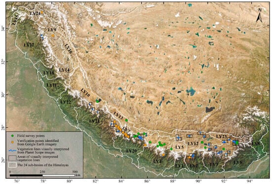
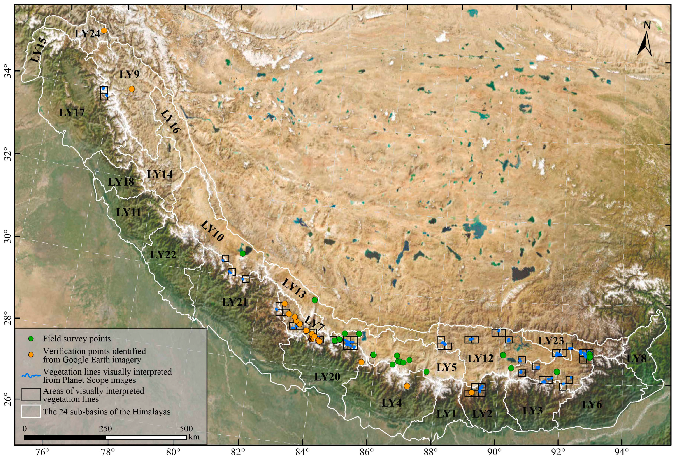
The data used in this study include Landsat reflectance, DEM, land cover products, and validation datasets of vegetation lines obtained in three ways (Table A1). Firstly, we conducted field surveys on the northern slopes of the Himalayas in China from 2022 to 2023, recording the longitude, latitude, elevation, and vegetation coverage near the vegetation lines. In total, we completed 57 field verification points (Figure 1). Conducting extensive field surveys of vegetation lines in the high-elevation areas of the Himalayas is challenging, and the existing ecological datasets available for validating vegetation lines are limited [25]. To collect as extensive validation datasets as possible, we also performed visual interpretation of vegetation lines using Planet Scope imageries (3 m) and Google Earth imageries (<1 m) to verify further the accuracy of the vegetation lines identified from Landsat data [29,30]. We visually interpreted approximately 500 km of vegetation line dataset based on Planet images acquired in July and August from 2022 to 2023 (Figure 1, Table A1). However, most Google Earth imagery does not correspond to the growing season. To accurately determine the positions of the vegetation lines, we searched for publicly accessible photographs where they could be clearly identified, aiding in their position determination (Figure A1). Although these photographs were not explicitly taken for our study, they can provide basic ecological information, such as geographic coordinates and the presence or absence of vegetation, which has also been used in other studies [25]. A total of 72 verification points were collected using this strategy, primarily located on the southern slopes of the Himalayas (Figure 1).
Figure 1.
Spatial distribution of field survey points, verification points identified from Google Earth imagery, and vegetation lines visually interpreted from Planet Scope images.
2.2. Vegetation Cover Mapping and Preprocessing
The vegetation index is commonly used to map vegetation cover [26,31,32]. The Normalized Difference Vegetation Index (NDVI) is the most widely used vegetation index for mapping vegetation distribution areas [32]. Although NDVI is the most popular index used for vegetation assessment, it is not universally effective. For example, NDVI is inevitably affected by soil reflectivity in sparse vegetation areas and suffers from saturation effects in densely vegetated areas [33,34]. When NDVI is insufficient for vegetation assessment or other purposes, alternative vegetation indices may be considered [32]. In higher-elevation mountains, vegetation cover is generally sparse [35]. In such areas, where vegetation cover is typically less than 25%, a Modified Soil-Adjusted Vegetation Index (MSAVI), which minimizes the influence of bare soil brightness, may be more appropriate [36,37,38]. Therefore, we used the median composite MSAVI from Landsat images during the growing season (June to September) between 2015 and 2021 to map vegetation cover and identify vegetation lines. To determine the optimal threshold for distinguishing between the presence and absence of vegetation, firstly, we extracted pixels consistently classified as bare land from four different land cover products and used them as bare land sample points (226,798) [39]. Subsequently, we selected the MSAVI value at the 92th percentile (Figure A2) as the optimal threshold to distinguish between the presence or absence of vegetation.
Based on the optimal threshold, we transformed the MSAVI image into a binary image in which vegetation pixels have a value of 1 and non-vegetation pixels have a value of 0. Identifying the vegetation boundaries from this derived vegetation map could be confounded by small patches of non-vegetated (vegetated) patches scattered inside a vegetated (non-vegetated) area. To avoid these problems, we filled non-vegetated patches, in which the elevation of the filled area was within the elevation of the natural vegetation area, to ensure the filled area did not mislead the subsequent identification of vegetation boundaries. Additionally, we removed small, vegetated patches scattered within non-vegetated areas. These strategies were also applied to identify treelines based on satellite remote sensing [8]. The above operations were all completed in ArcGIS 10.8.
2.3. Edge Detection and Vegetation Lines Identification
Based on the vegetation image processed in the previous step, we employed the Canny edge detection algorithm to identify the vegetation boundary pixels in the Himalayas using the OpenCV package [40]. The Canny edge detection algorithm [28], which is an edge detection algorithm that uses spatial gradient information, has been widely used to identify treelines, alpine grasslines, and coastlines [8,13,41].
Accurately identifying the upper-edge pixels of vegetation from the boundary pixels detected by Canny edge detection algorithms is a critical step in determining vegetation lines. In mountainous areas, land cover gradually transitions from vegetation to non-vegetation with increasing elevation. The upper regions of the vegetation’s upper edges are consistently covered by non-vegetation pixels. Consequently, the elevation differences between non-vegetated and vegetated pixels near the vegetation’s upper edges are expected to be positive. In contrast, elevation differences near other edges should be opposite. These significant elevation differences can be used to identify vegetation’s upper-edge pixels from boundary pixels. Therefore, we first calculated the elevation differences (DEVB) between the median elevation of non-vegetated and vegetated pixels within a specific window size centered on all vegetation boundary pixels to identify the vegetation’s upper edge from the boundary pixels. We calculated DEVB based on multiple window sizes and, through repeated trial and error, determined the optimal window size and the DEVB threshold for identifying vegetation edge pixels. The algorithm is represented as follows (Algorithm 1):
where and are the median elevations of vegetation and non-vegetation pixels within a window, respectively. and are the rasters of vegetation and non-vegetation cover, respectively. is the raster detected by Canny edge detection algorithms. N represents the window size. represents the value of vegetation boundaries. T is the threshold distinguishing the vegetation’s upper and lower edge pixels.
| Algorithm 1 Fast tree |
| 1: |
| 2: |
| 3: |
However, local topographical uplift or collapse may cause a small number of vegetation edge pixels to meet the condition of positive DEVB values. However, such pixels do not represent vegetation lines. The vegetation line elevations at local scales are assumed to follow a Gaussian distribution [8]. Therefore, we applied the Gaussian function to fit the elevations of the upper-edge pixels obtained in the previous step and defined elevation thresholds based on the 95% confidence interval to determine the vegetation lines further. Given the Himalayas’ vast elevation range and complex topography, applying a single universal elevation threshold to determine the vegetation lines is problematic. To address this, we divided the Himalayas into 24 sub-basins based on global HydroBASINS data [42] (Figure 1). The Gaussian function was applied to fit the upper-edge pixel elevations within each sub-basin and determine the optimal elevation thresholds for identifying the vegetation lines applicable to each region.
where α, μ, and σ are amplitude, centroid, and standard deviation in Gaussian function, respectively. The values (μ − 2σ and μ + 2σ) were used as elevation thresholds to define the vegetation upper lines.
2.4. Validation and Coverage of the Vegetation Lines
To verify the accuracy of the vegetation lines identified using this method, the vegetation lines visually interpreted from Planet Scope images were first resampled to a 30-m resolution. Then, each pixel of the interpreted vegetation lines was matched with the closest vegetation lines identified from Landsat images within a 2 km range, based on the nearest distance [13]. The same approach matched the vegetation line pixels with the verification points identified from Google Earth imagery and field survey. Finally, we quantified the positional accuracy of the vegetation lines using the mean absolute error (MAE), root mean squared error (RMSE), and the adjusted R² from a linear regression model.
Furthermore, we determined the vegetation coverage in the vegetation line areas identified using this method based on field survey results and unmanned aerial vehicle (UAV) images. The specific steps for determining vegetation coverage based on UAV imagery are as follows: First, we calculated the vegetation index (ExG-ExR) using the Red, Green, and Blue (RGB) bands from UAV imagery [43] and converted the results into binary (vegetation and non-vegetation) images using the Otsu algorithm with the ‘imagemetrics’ package in R [44]. The vegetation coverage was then calculated as the percentage of vegetation pixels relative to the total pixels in the entire image (Figure A3).
3. Results
3.1. Mapping the Vegetation Lines
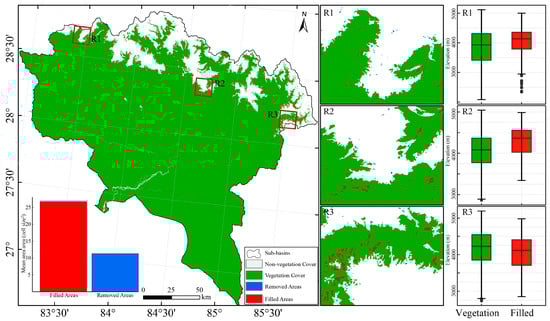
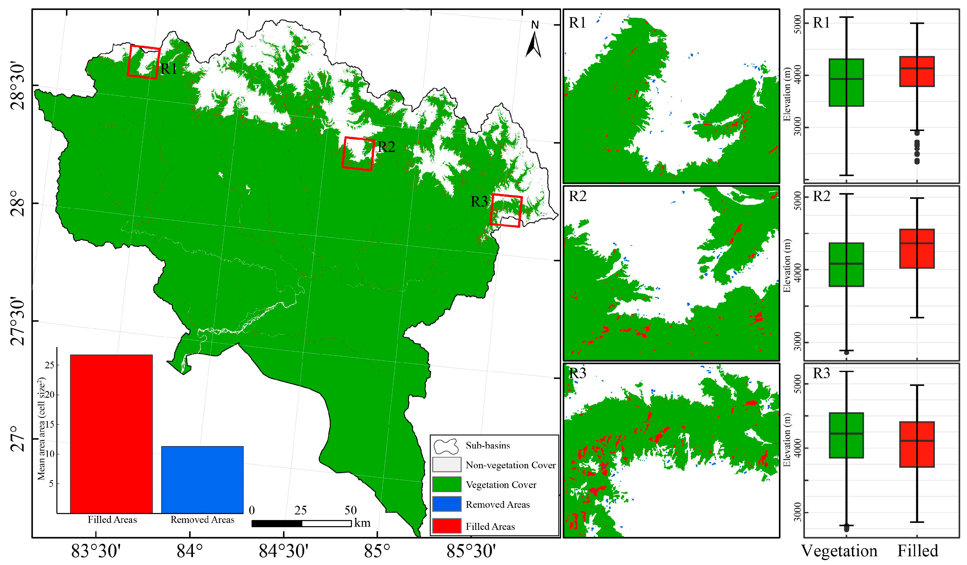
To reduce the impact of complex vegetation distribution patterns on vegetation line identification, non-vegetation patches embedded within vegetated areas were filled, while isolated, small vegetation patches embedded within non-vegetated regions were removed. To present the results more clearly, we selected one of the 24 sub-basins in the Himalayas as an example to demonstrate the results (Figure 2). In this sub-basin, the mean area of removed vegetation patches (less than 1 ha) is significantly smaller than that of the filled non-vegetation patches (less than 3 ha, Figure 2). Despite the relatively large area of the filled patches, their elevations do not exceed those of nearby vegetation at both local scales and the Himalayas (Figure A4 and Figure A5). This means these approaches avoid introducing artificial errors during the subsequent identification of vegetation boundaries.
Figure 2.
Spatial distribution of vegetation, filled non-vegetation patches and removed vegetation patches in the LY20 sub-basin of the Himalayas. The box plots show the elevations of vegetated and filled non-vegetation patches across three sub-regions within this sub-basin.
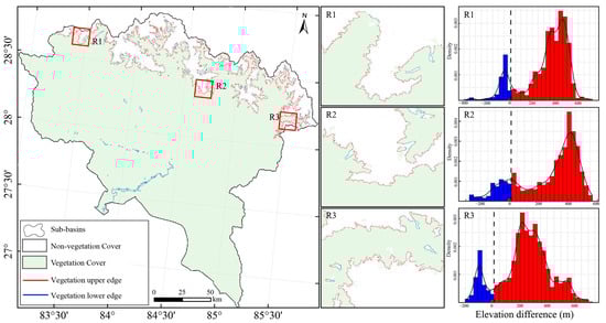
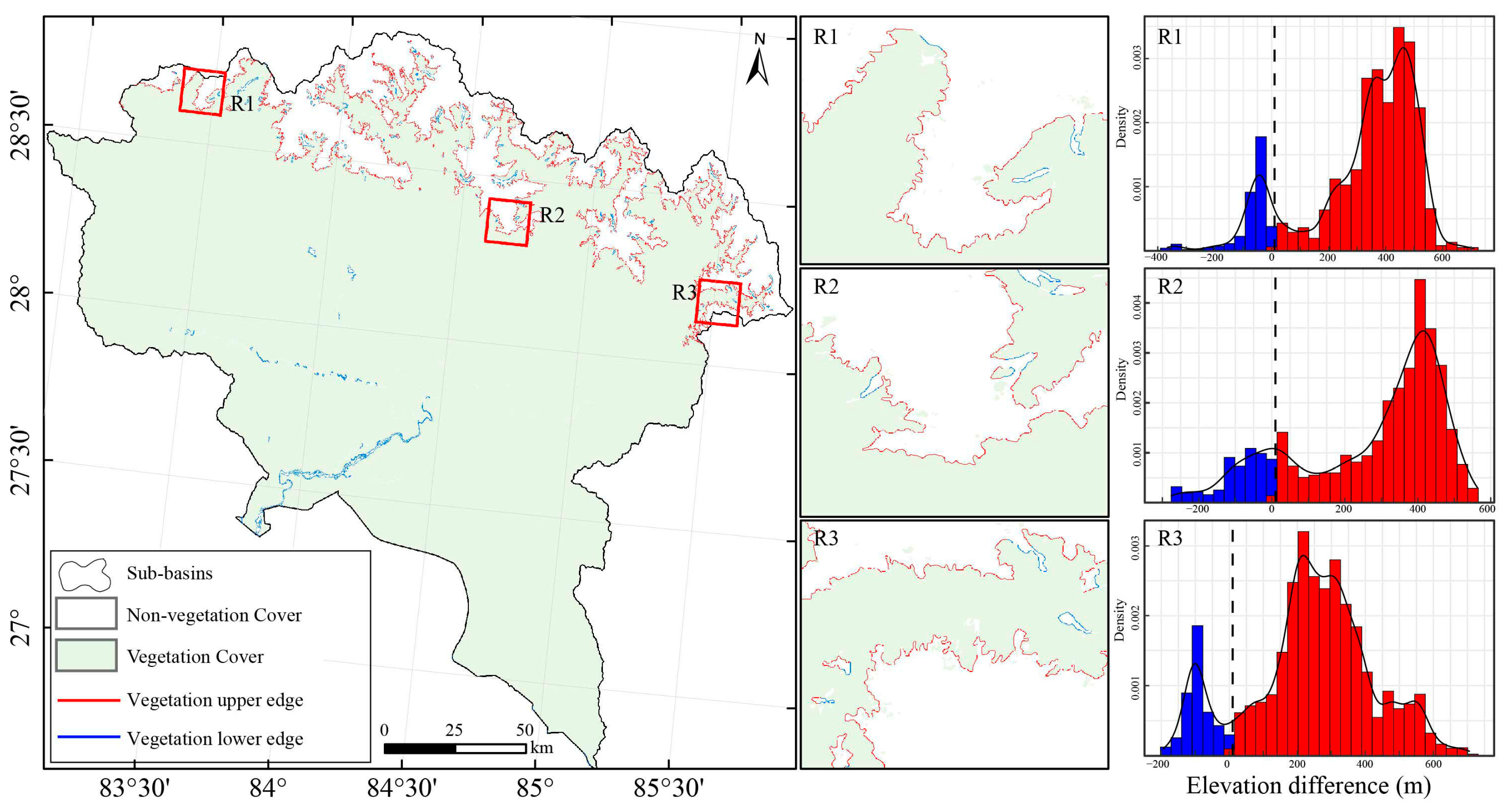
Significant differences are observed in the DEVB values and their distributions calculated from different window sizes (Figure A6 and Figure A7). When the window size is 55 pixels, the DEVB values range from −400 to 800 m and show a distinct bimodal distribution in the Himalayas (Figure A7). The DEVB values are unaffected by the vast elevation range across the Himalayas. The bimodal distribution pattern of DEVB values can also be observed at the more minor scales (Figure 3 and Figure A7). This indicates that a window size of 55 pixels can be optimal for calculating DEVB. Further, after experimentation, we determined that a DEVB value of ten can serve as a practical threshold for distinguishing between vegetation’s upper and lower edges (Figure 3 and Figure A7). Consequently, we removed all pixels with DEVB values of less than 10 in further analysis.
Figure 3.
Spatial distribution of upper and lower vegetation edges identified by elevation differences in the LY20 sub-basin of the Himalayas. The histograms show the distribution of elevation differences of the upper and lower edges across three sub-regions within this sub-basin. The black dotted line represents the value 10.
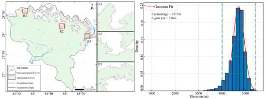
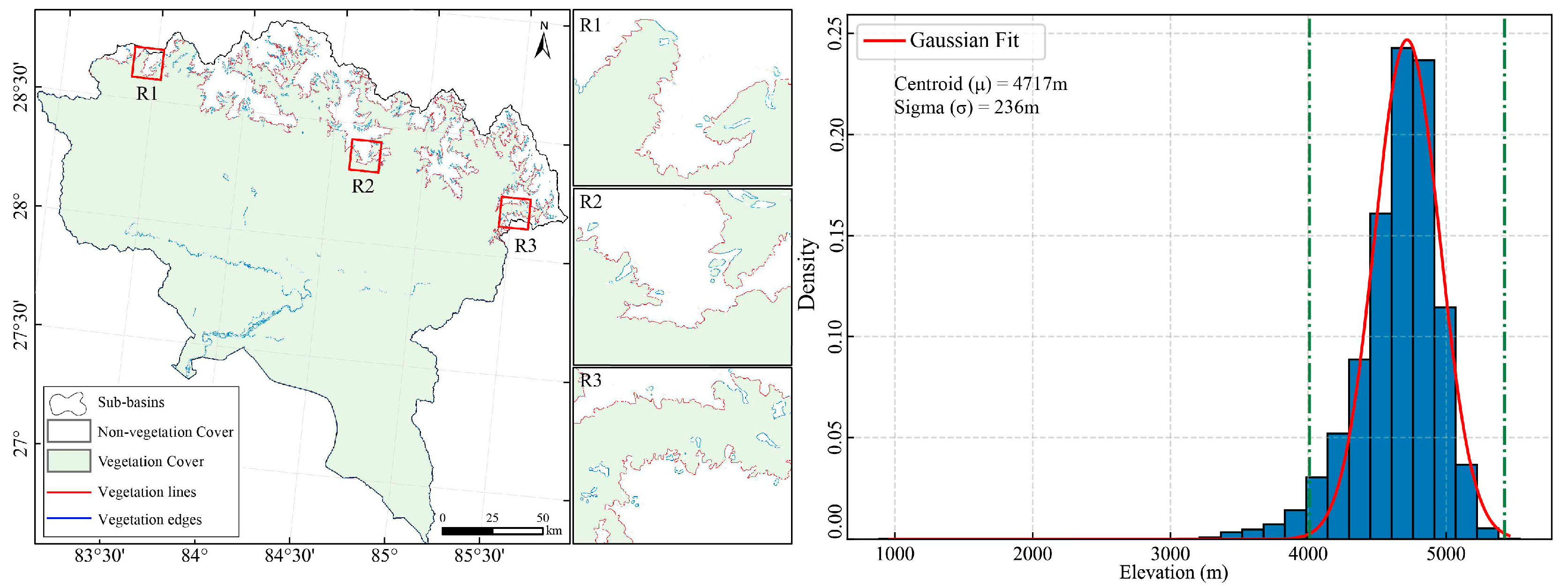
In each sub-basin, vegetation upper edge pixel elevations generally follow a Gaussian distribution (Figure A8). However, significant differences in the centroid (μ) and sigma (σ) values calculated using a Gaussian function are observed between 24 sub-basins (Figure A8). For instance, in the LY16 sub-basin of the northwest Himalayas, the centroid and sigma of vegetation upper-edge pixel elevations calculated using a Gaussian function are 5315 m and 257 m, respectively (Figure A8). In contrast, in the LY3 sub-basin of the southeast Himalayas, the centroid and sigma are 4926 m and 208 m, respectively (Figure A8). In the LY20 sub-basin, used as an example above, the centroid and sigma are 4717 m and 236 m, respectively (Figure 4). Consequently, the elevation thresholds for determining vegetation lines were 4245 m (μ − 2σ) and 5189 m (μ + 2σ) (Figure 4). The elevation thresholds for determining vegetation lines in other sub-basins were also calculated using the same method.
Figure 4.
Spatial distribution of vegetation lines and their elevations in the LY20 sub-basin of the Himalayas. The green dotted lines represent μ − 2σ and μ + 2σ values, respectively.
3.2. Accuracy and Coverage of Vegetation Lines
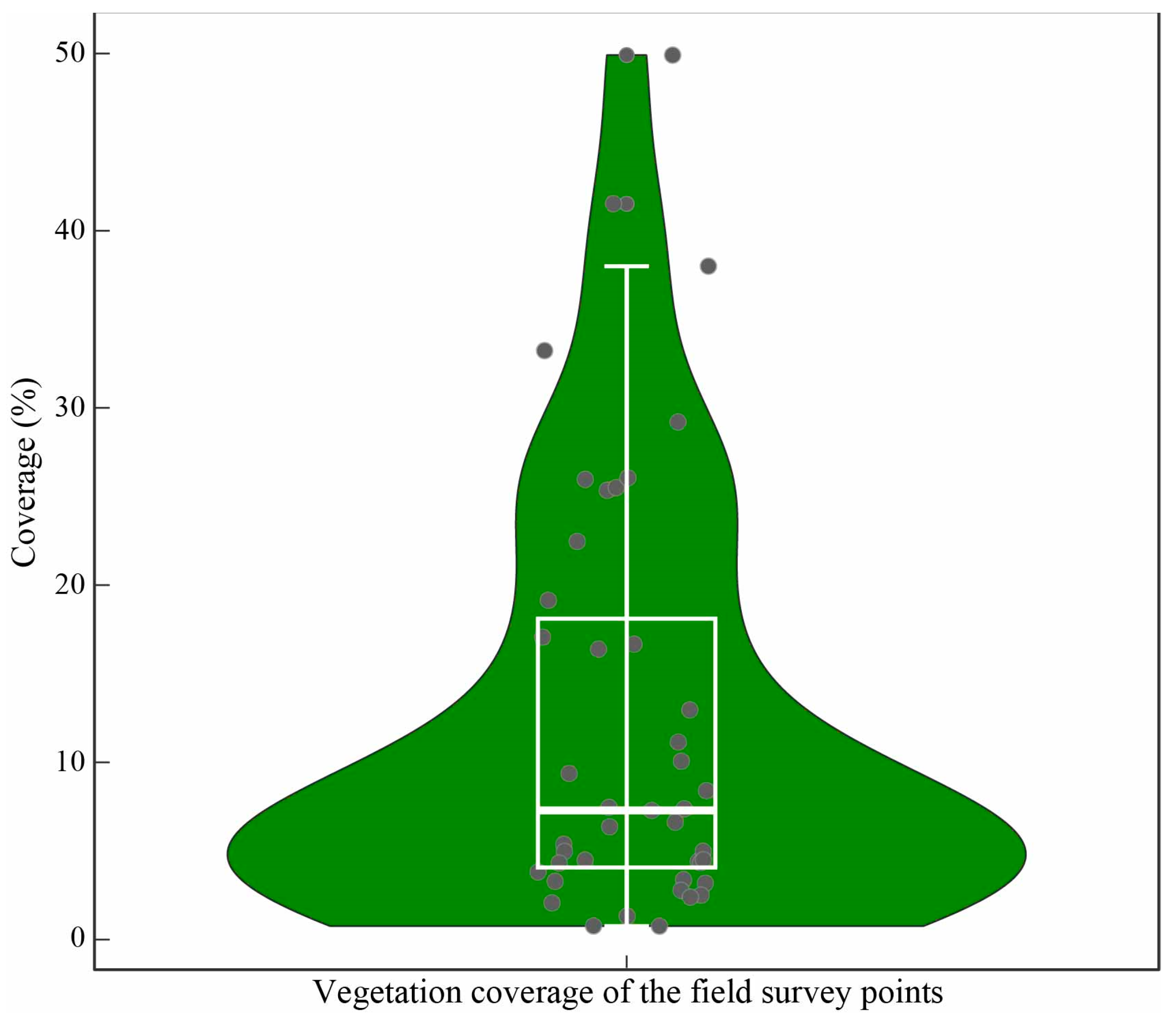
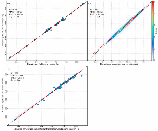
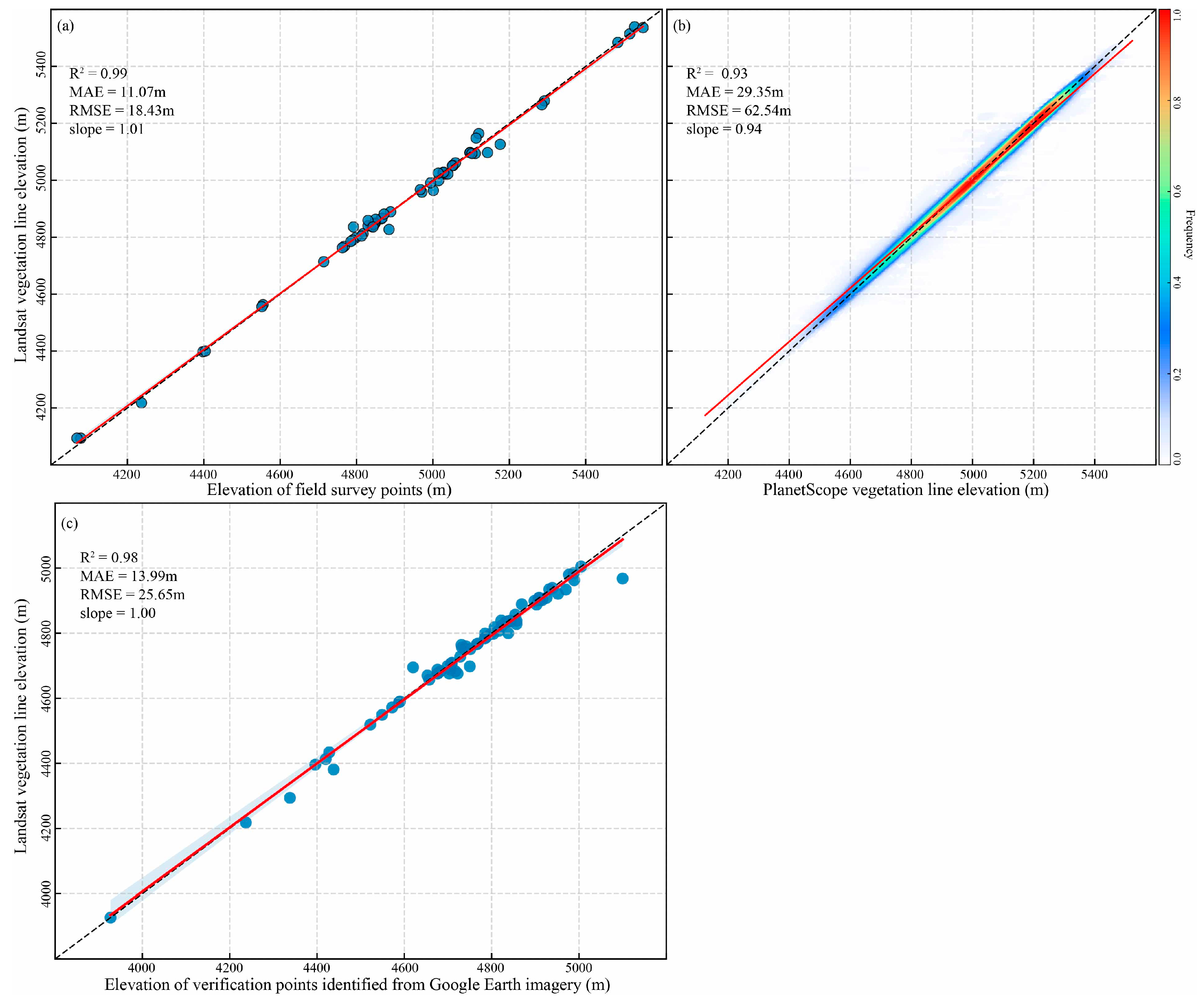
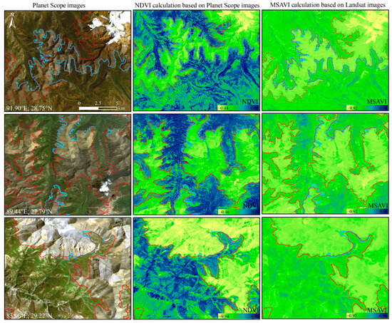
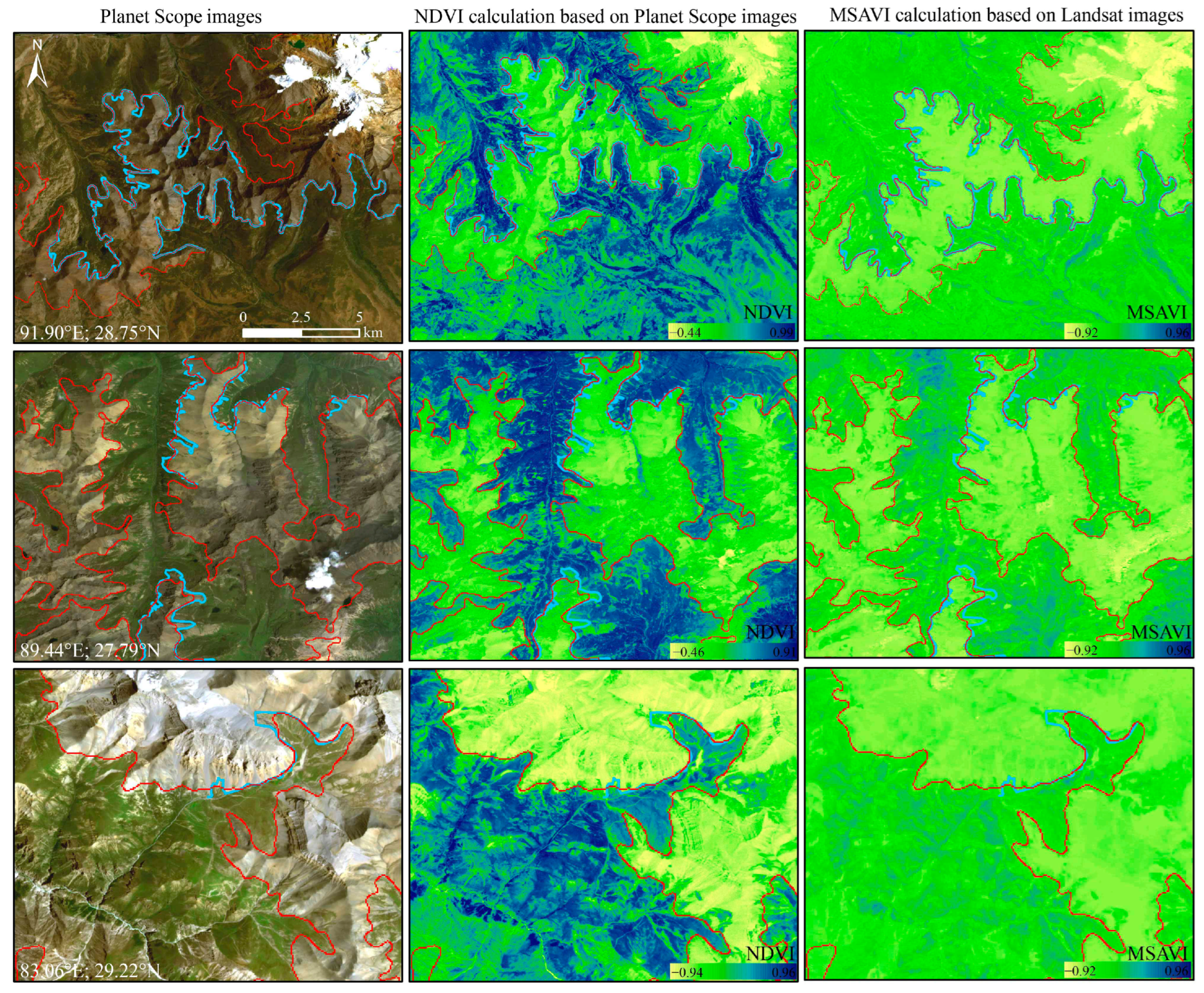
The mean absolute error (MAE) between the vegetation line elevations identified from Landsat images and those from field survey points, vegetation upper lines visually interpreted from Planet Scope images, and verification points identified from Google Earth imagery were 11.07 m, 29.35 m, and 13.99 m, respectively (Figure 5). The root mean square error (RMSE) values were 18.43 m, 62.54 m, and 25.65 m, respectively (Figure 5). The R² values were 0.99, 0.93, and 0.98, respectively (Figure 5). A visual comparison using Planet Scope images also demonstrates that the method proposed in this study can effectively identify vegetation lines in the Himalayas and is highly accurate (Figure 6 and Figure A9). Based on land cover products and field surveys, more than 80% of vegetation lines represent the upper elevational limit of continuous alpine grassland (Figure A10). They also include the upper elevational limit of a small portion of shrubs and subnival vegetation (Figure A10). Field surveys indicate that the coverage of vegetation lines is primarily concentrated around 7%, with the highest coverage exceeding 50% (Figure A11).
Figure 5.
Validation of vegetation lines identified from Landsat images: Comparison of their elevations with field survey points (a), visually interpreted vegetation lines from Planet Scope images (b), and verification points from Google Earth imagery (c). MAE and RMSE represent mean absolute and root mean squared errors, respectively. The red line is the linear fit between the elevations of verification points and the vegetation lines. The black dashed line is the 1:1 line.
Figure 6.
Spatial distribution of vegetation lines identified from Landsat images (red lines) and visually interpreted (blue lines) in three regions of the Himalayas.
3.3. Spatial Pattern of Vegetation Lines in the Himalayas
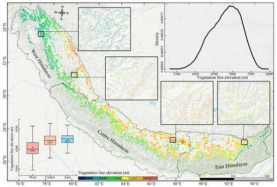
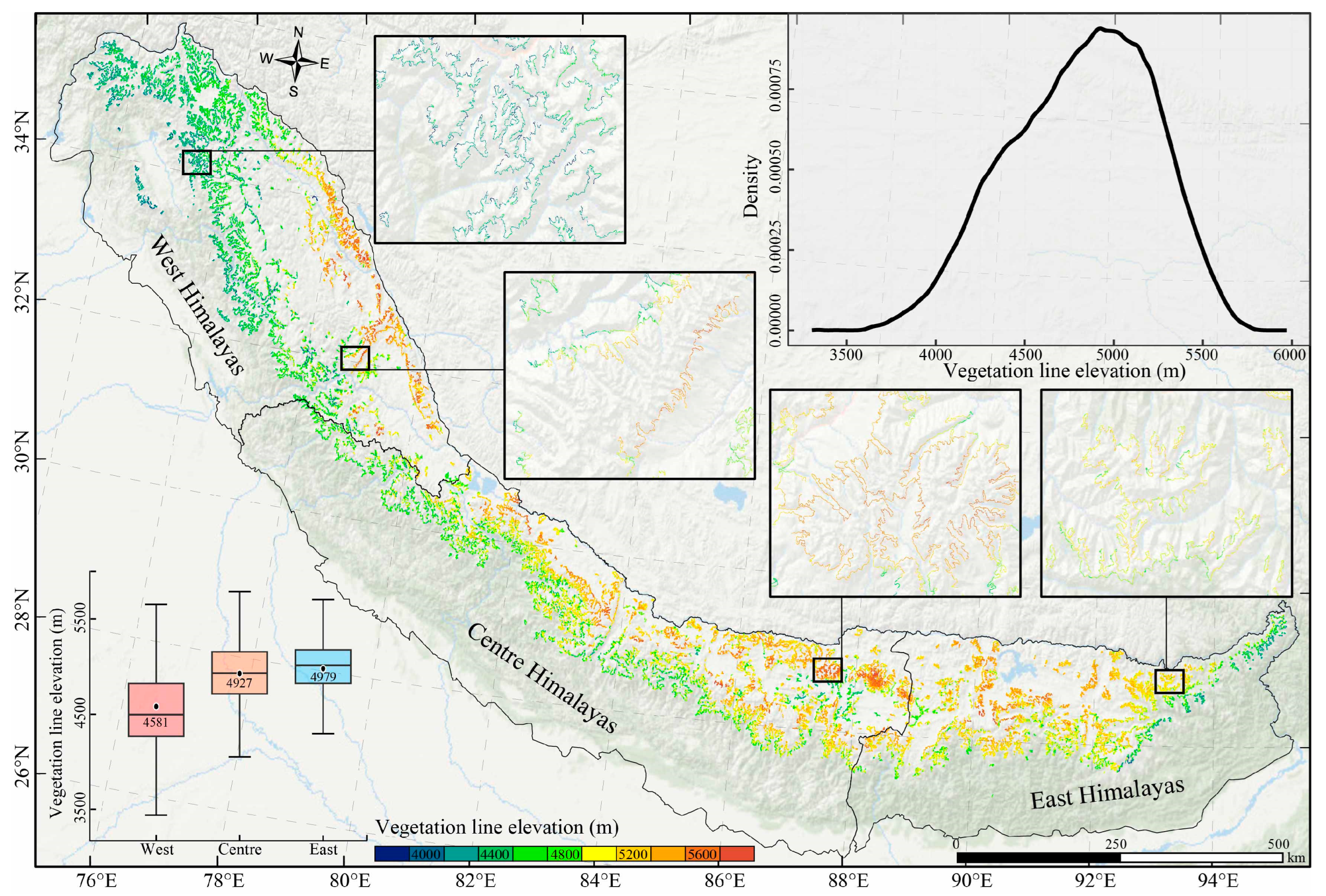
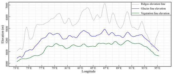
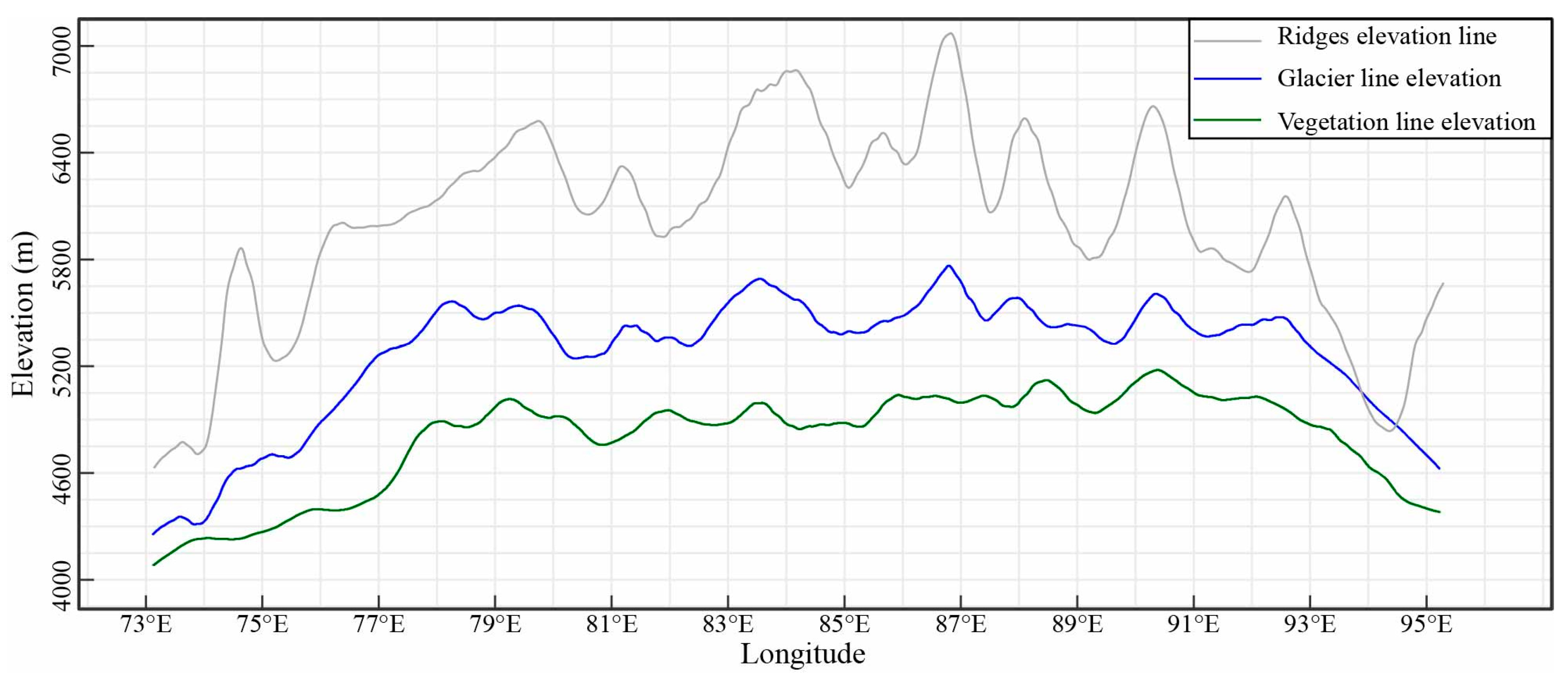
Across the Himalayas, vegetation line elevations vary significantly, ranging from 4125 m at the 5th percentile to 5423 m at the 95th percentile (Figure 7). The mean vegetation line elevation is 4816 m, and the median elevation is 4849 m. Longitudinally, the mean vegetation line elevations in the Himalayas begin at approximately 4123 m at 73°E, rise to about 5200 m at 90.5°E, and then decrease to around 4300 m at 95°E. The spatial patterns of vegetation lines along longitude in the Himalayas parallel the trend of the purely physics-driven snowline (Figure 8). Regionally, the mean vegetation line elevations in the western, central, and eastern Himalayas are 4581 m, 4927 m, and 4979 m, respectively (Figure 7). However, the variation in vegetation line elevations is considerably more significant in the western Himalayas than in other regions, while the eastern Himalayas exhibit the lowest variation (Figure 7).
Figure 7.
The spatial patterns and histogram of the vegetation line elevations in the Himalayas.
Figure 8.
Elevation changes of ridges, glaciers, and vegetation lines along longitude in the Himalayas. These three curves were smoothed using the loess function.
4. Discussion
It is widely expected that species’ distributions, currently limited by low temperatures and short growing seasons, will shift uphill under future warming [8,17,45]. The Himalayas have experienced significant warming over the past decades [20], and treelines are shifting to higher elevations in the region [8,17]. These upslope shifts are expected to continue under future warming, potentially resulting in the loss of habitats for endemic flora in the local areas [8]. However, there is still no unified understanding of the spatial patterns and changes in vegetation lines above the treelines in the Himalayas [10,19,25]. These issues originate from the lack of large-scale vegetation line dataset retrieved through remote sensing in the Himalayas. This study proposed a method that combines the Canny edge detection algorithm with elevation parameters to identify vegetation lines using satellite remote sensing. Further, using this method, the vegetation line dataset across the Himalayas, with a spatial resolution of 30 m, was identified from Landsat images (Figure 7).
Accurately mapping the vegetation distribution is a foundation for identifying the vegetation lines in the region of interest. In previous studies, vegetated areas are commonly determined by a vegetation index threshold [26,31]. In this study, MSAVI was employed to determine the vegetated areas in the Himalayas, instead of the widely used NDVI, because MSAVI is designed to minimize soil background influences and enhance the dynamic range of the vegetation signal, making it theoretically more reliable for identifying vegetated areas with sparse vegetation coverage [32,33,36,37,46]. However, determining vegetation lines based on the map identified by the MSAVI threshold can be confounded by non-vegetated boundaries (such as rivers, roads, and lakeshore lines) embedded within vegetated areas. To avoid these issues, we filled in non-vegetated patches scattered within the vegetated areas (Figure 2). The elevations of these artificially filled vegetation patches did not exceed the surrounding natural vegetation (Figure 2 and Figure A5). This means that this operation helps effectively identify vegetation lines in subsequent steps without introducing artificial errors. Moreover, isolated, small-scale vegetation patches were removed (Figure 2). These steps function like a large-scale filtering process designed to smooth the data and minimize the effects of vegetation area fragmentation in identifying vegetation lines. Similar operations are also used in research on identifying treelines using remote-sensing images [8]. Subsequently, the Canny edge detection algorithm was employed to detect the boundaries of the vegetation map obtained in the previous step.
However, the boundaries detected by the Canny edge detection algorithm include vegetation’s lower and upper edges. In a previous study, various elevation thresholds were used to distinguish the upper and lower edge pixels of forests in the Himalayas [8]. However, above the treelines, vegetation distribution becomes more fragmented, with boundaries often overlapping riverbanks, lake shores, and other features. Moreover, the lack of significant elevation differences among these boundaries makes it challenging to distinguish the upper edges of vegetation from these complex features using elevation thresholds alone. Therefore, this study proposed a strategy for identifying the upper edge of vegetation by elevation differences between non-vegetation pixels and vegetation pixels within a 55-pixel window size centered on vegetation boundary pixels (Figure 3, Figure A6 and Figure A7). This strategy can effectively identify the upper edge of vegetation without being affected by significant elevation differences in the region. The elevation of upper-edge pixels of vegetation identified using this strategy generally follows a Gaussian distribution in each of the 24 sub-basins of the Himalayas (Figure 4 and Figure A8). Therefore, we retained all pixels within the 95% confidence interval in each sub-basin based on Gaussian fitting as the vegetation lines in the Himalayas (Figure 4). Validation datasets obtained through multiple approaches have indicated the high accuracy of this vegetation line dataset, which was identified using the proposed method in this study (Figure 5, Figure 6 and Figure A9). The vegetation line elevations also align with the findings of multiple local studies conducted in the Himalayas [21,22,24]. Due to resolution limitations, vegetation with low coverage cannot be effectively identified using Landsat images with a resolution of 30 m. The vegetation lines identified in this study are primarily the upper elevation limit of continuous vegetation with coverage higher than 7% (Figure A11). Over 80% of the vegetation lines are the upper elevation limit of continuous alpine grasslands; the others represent the upper elevation limit of shrubs and subnival vegetation (Figure A10). It should be noted that the validation datasets used to evaluate the accuracy of vegetation lines identified in this study do not overlap temporally with the Landsat images employed for vegetation lines identification (Table A1). Given that the positions of vegetation lines may shift over time due to climate change [10,23,27], these non-overlapping datasets may introduce some uncertainty in the accuracy and vegetation cover assessments.
The vegetation line elevation ranges in the Himalayas identified using the method proposed in this study are comparable to those determined using the VIEG model and to the alpine grasslines identified using the graph-cut algorithm in previous studies [13,15]. Compared to the VIEG model, the proposed method can identify the positions of vegetation lines without losing data resolution. This allows for a more detailed analysis of regional variations and dynamic changes in vegetation line elevations at a finer scale. Compared with the graph-cut algorithm, which also employs the Canny edge detection algorithm, the method proposed in this study emphasizes the role of elevation differences between two types of land cover (vegetation and non-vegetation) in identifying alpine vegetation lines (Figure 3). Unlike the graph-cut algorithm, the method proposed in this study employs specific regional elevation thresholds at the basin scale. The thresholds determined in this study may not be directly transferable to other areas because of the significant elevation variations across different mountainous regions. Nevertheless, the proposed method mainly relies on the elevation difference between vegetation and non-vegetation arising from their transitions along the elevation gradient. These transition patterns are common in other mountainous regions and are independent of the absolute elevation. Therefore, the framework proposed in this study holds the potential for identifying vegetation lines in other mountainous areas.
Undeniably, the method proposed in this study involves some uncertainty. Firstly, vegetation indices exhibit suboptimal performance in the shadowed areas of the mountain [47]. As a result, relying on a single MSAVI threshold to indicate vegetation presence may introduce some bias, particularly in these shaded regions, potentially reducing the reliability of the identified vegetation lines in such areas. Secondly, identifying comprehensive vegetation lines in the Himalayas using Landsat images spanning only a few consecutive years is challenging due to persistent cloud cover on the southern slopes and southeastern regions during the growing season, influenced by the Indian monsoon [14,48]. Although vegetation lines can be identified more comprehensively using Landsat images from growing seasons over seven consecutive years, this approach may overlook the shifts in vegetation lines driven by climate change. These limitations can potentially be addressed in future research by integrating multi-source remote-sensing data and further optimizing key parameters.
5. Conclusions
This study proposed a novel method for automatically identifying vegetation lines from Landsat images and mapped a comprehensive vegetation line dataset of the Himalayas with a 30 m spatial resolution. Field verification and visually interpreted vegetation line verification points showed that the vegetation lines identified in this study had high accuracy. Across the Himalayas, vegetation line elevations range from 4125 m (5th percentile) to 5423 m (95th percentile), increasing and then decreasing from southeast to northwest, and show a parallel trend with the purely physics-driven snowline. Our study first identified vegetation lines with 30 m resolution across the Himalayas, providing a crucial foundation for understanding the response of vegetation ranges to climate change in this region. Furthermore, the proposed method offers a significant reference for identifying vegetation lines in other regions.
Author Contributions
Conceptualization, funding acquisition, project administration, supervision, L.L. (Linshan Liu) and Y.Z.; Formal analysis, writing—original draft preparation, methodology, software, visualization, B.W.; Visualization, investigation, software, D.G. and B.Z.; Visualization, writing—review and editing, L.L. (Lanhui Li), C.G. and B.P. All authors have read and agreed to the published version of the manuscript.
Funding
The study was funded by the Second Tibetan Plateau Scientific Expedition and Research (Grant No. 2019QZKK0603) and the Strategic Priority Research Program of the Chinese Academy of Sciences (Grant No. XDA20040201).
Data Availability Statement
All the data were created in this study can be provided by the corresponding author upon reasonable request.
Acknowledgments
We would like to thank Huange Xu, Xiaoyang Hu, and Haonan Cheng for providing help with the field investigation.
Conflicts of Interest
The authors declare no conflicts of interest.
Appendix A
Table A1.
Datasets used in this study.
Appendix B
Figure A1.
The photographs of vegetation lines could be identified, and verification points (the red dots, numbered S1 to S3 in the figures) were extracted from Google Earth imagery.
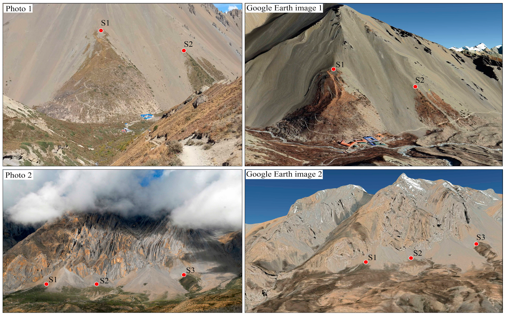
Figure A2.
MSAVI values for bare land sample points (a) and their standard deviation at different percentiles (b). After the 92th percentile, the standard deviation of MSAVI values for bare land samples increases sharply.
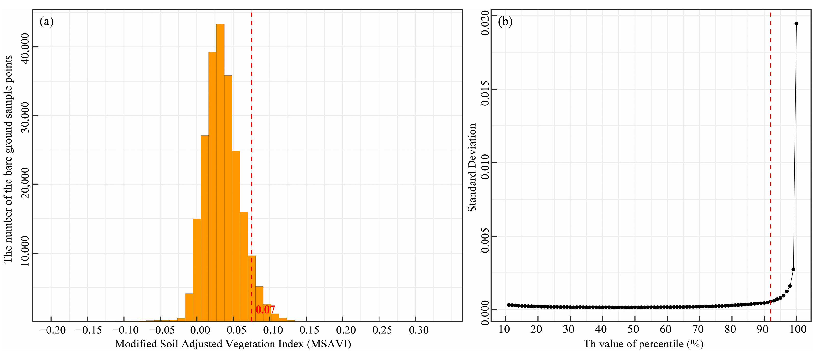
Figure A3.
Field photo (a) captured by unmanned aerial vehicles (UAV) and vegetation cover (b) identified using RGB bands.
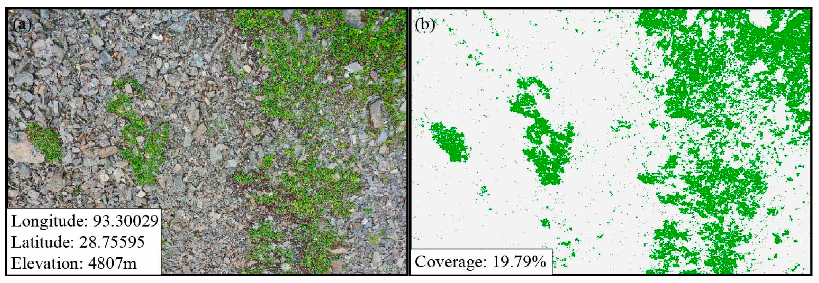
Figure A4.
The area of filled non-vegetation areas (a) and removed vegetation areas (b) in the Himalayas.
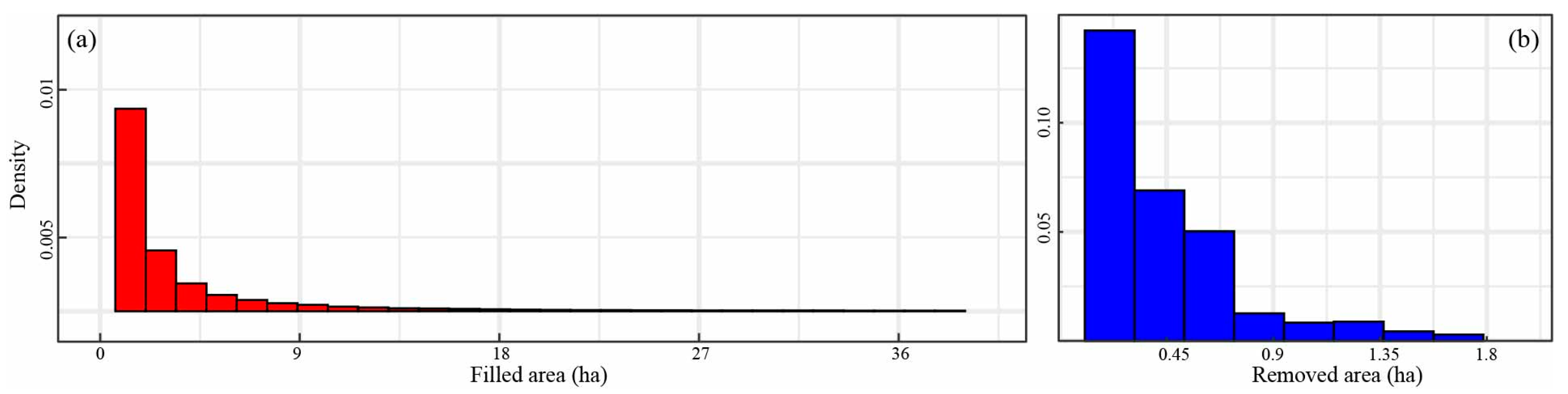
Figure A5.
Histogram of vegetation and filled area elevations in the Himalayas.
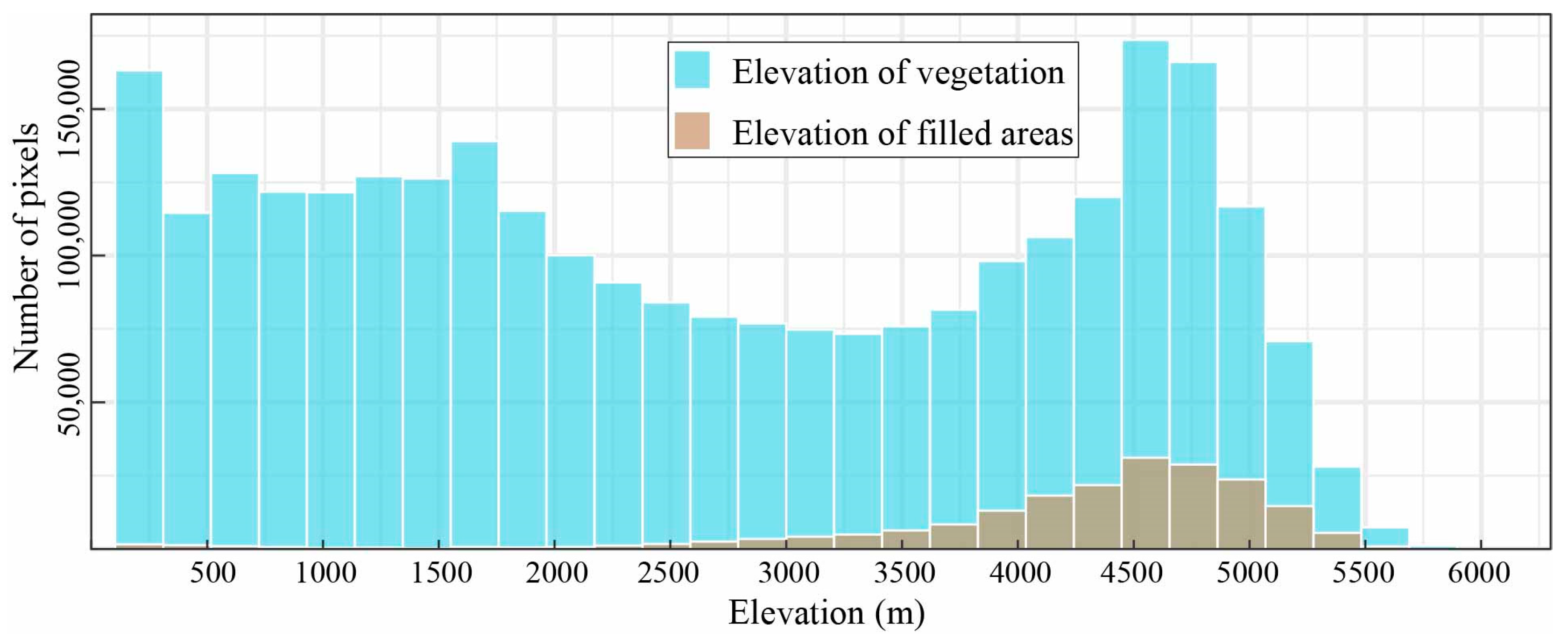
Figure A6.
The elevation differences between the median elevation of non-vegetated and vegetated pixels within various window sizes centered on all vegetation boundary pixels.
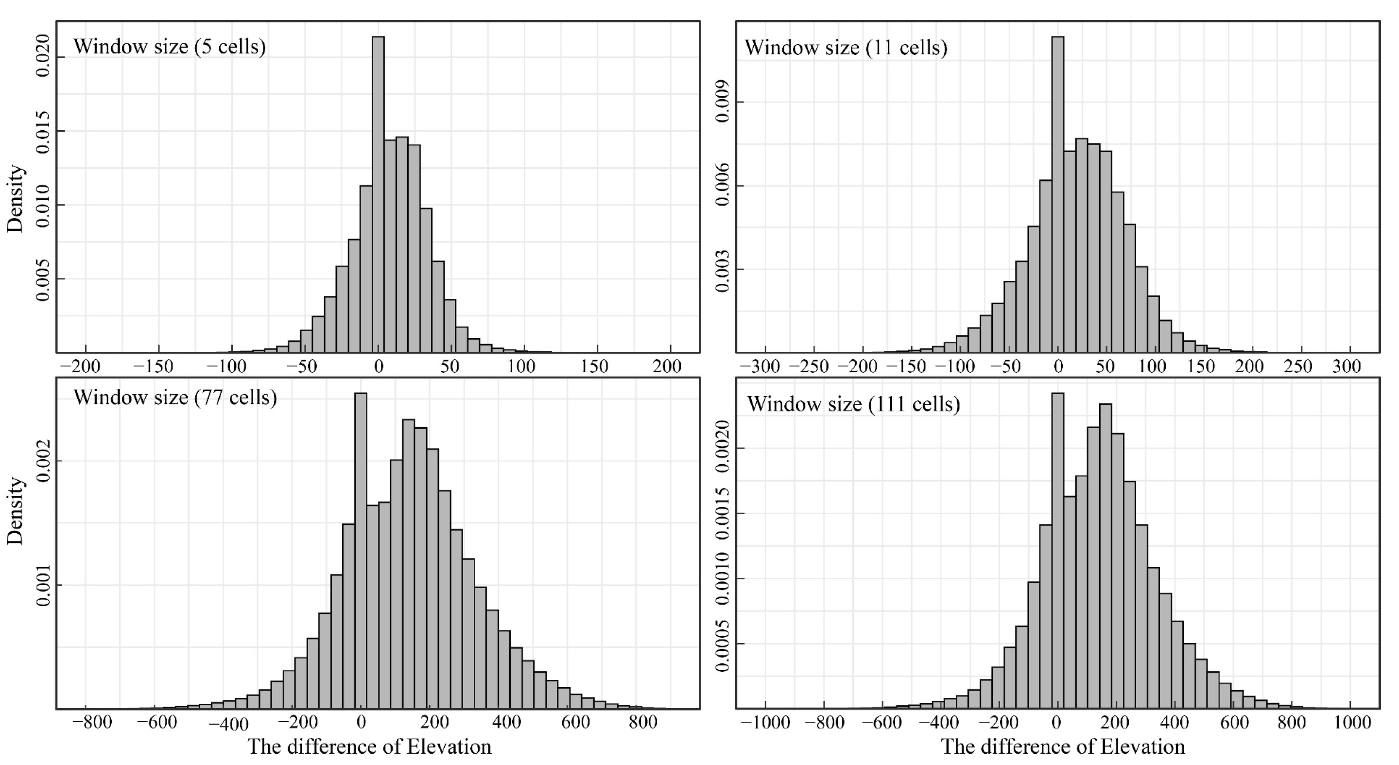
Figure A7.
The elevation differences between the median elevation of non-vegetated and vegetated pixels within 55-pixel window sizes centered on all vegetation boundary pixels. The blue and red bars represent negative and positive elevation differences, respectively. The red dotted line represents the value 10.
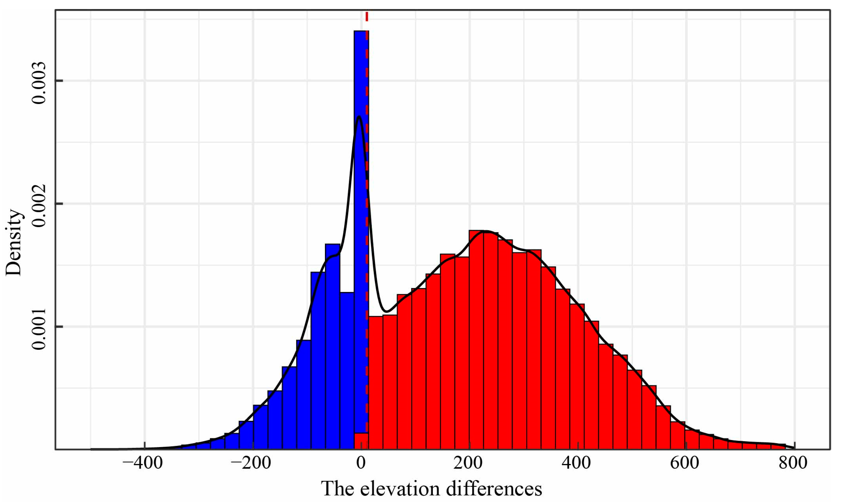
Figure A8.
Gaussian fit of the elevations of vegetation upper-edge pixels in 23 sub-basins. The green dotted lines represent the values of μ − 2σ and μ + 2σ, respectively.
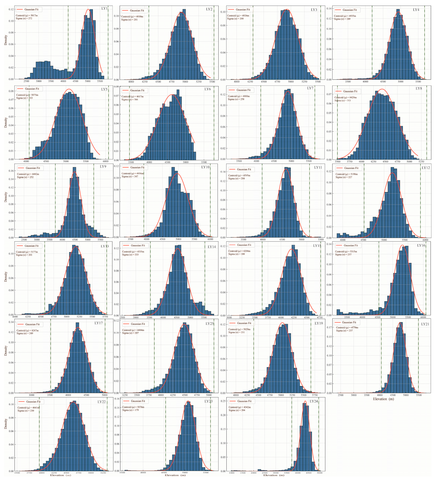
Figure A9.
Spatial distribution of vegetation lines on the northern slope of the Himalayas in Gyirong County and Nyalam County, China. The red lines represent the vegetation lines determined from field photographs. The blue lines represent the vegetation lines identified from Landsat images.
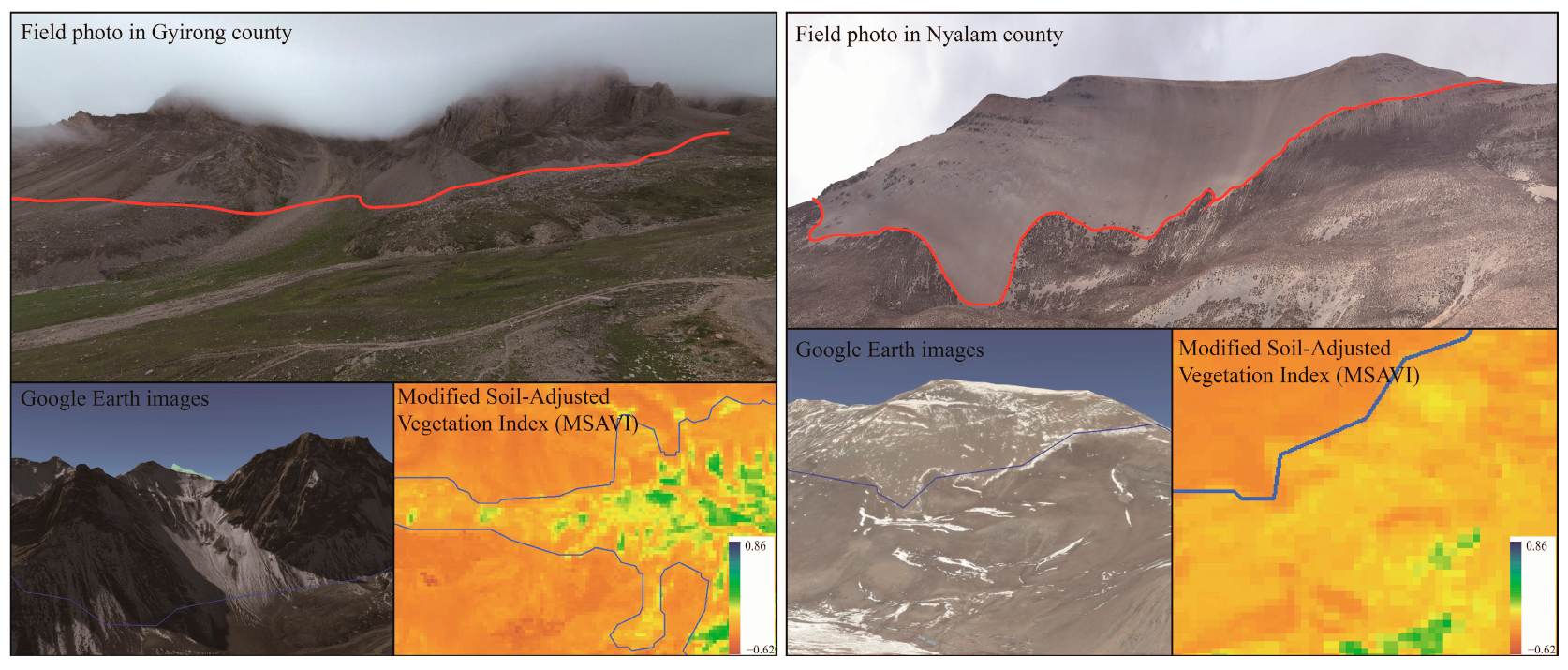
Figure A10.
The vegetation types in the vegetation line area in the Himalayas. The data are sourced from land cover products (a) and field surveys (b).
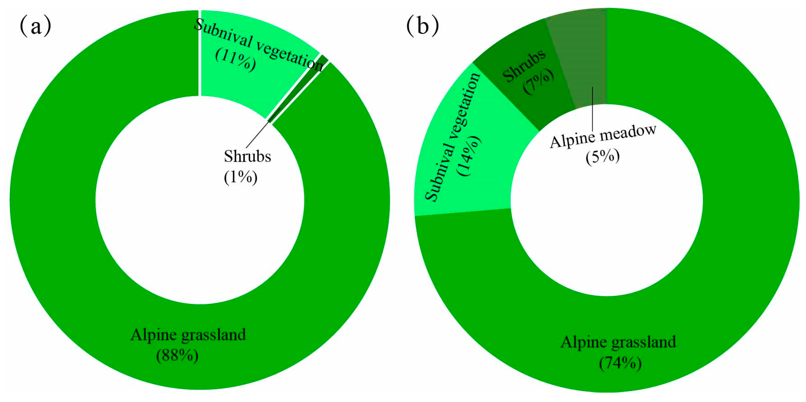
Figure A11.
Vegetation coverage at field survey points for the vegetation lines across the northern slopes of the Himalayas.
References
- Bürli, S.; Theurillat, J.-P.; Winkler, M.; Lamprecht, A.; Pauli, H.; Rixen, C.; Steinbauer, K.; Wipf, S.; Abdaladze, O.; Andrews, C.; et al. A common soil temperature threshold for the upper limit of alpine grasslands in European mountains. Alp. Botany 2021, 131, 41–52. [Google Scholar] [CrossRef] [Scilit]
- Lamprecht, A.; Semenchuk, P.R.; Steinbauer, K.; Winkler, M.; Pauli, H. Climate Change Leads to Accelerated Transformation of High-elevation Vegetation in the Central Alps. New Phytol. 2018, 220, 447–459. [Google Scholar] [CrossRef] [Scilit]
- Zu, K.; Wang, Z.; Zhu, X.; Lenoir, J.; Shrestha, N.; Lyu, T.; Luo, A.; Li, Y.; Ji, C.; Peng, S. Upward Shift and Elevational Range Contractions of Subtropical Mountain Plants in Response to Climate Change. Sci. Total Environ. 2021, 783, 146896. [Google Scholar] [CrossRef] [Scilit] [PubMed]
- He, X.; Jiang, X.; Spracklen, D.V.; Holden, J.; Liang, E.; Liu, H.; Xu, C.; Du, J.; Zhu, K.; Elsen, P.R. Global Distribution and Climatic Controls of Natural Mountain Treelines. Glob. Change Biol. 2023, 29, 7001–7011. [Google Scholar] [CrossRef] [Scilit] [PubMed]
- Zhu, K.; Song, Y.; Lesage, J.C.; Luong, J.C.; Bartolome, J.W.; Chiariello, N.R.; Dudney, J.; Field, C.B.; Hallett, L.M.; Hammond, M. Rapid Shifts in Grassland Communities Driven by Climate Change. Nat. Ecol. Evol. 2024, 8, 2252–2264. [Google Scholar] [CrossRef] [Scilit] [PubMed]
- Zu, K.; Wang, Z. Research Progress on the Elevational Distribution of Mountain Species in Response to Climate Change. Biodivers. Sci. 2022, 30, 21451. [Google Scholar] [CrossRef] [Scilit]
- Rehm, E.M.; Olivas, P.; Stroud, J.; Feeley, K.J. Losing Your Edge: Climate Change and the Conservation Value of Range-edge Populations. Ecol. Evol. 2015, 5, 4315–4326. [Google Scholar] [CrossRef] [Scilit]
- Wang, X.; Wang, T.; Xu, J.; Shen, Z.; Yang, Y.; Chen, A.; Wang, S.; Liang, E.; Piao, S. Enhanced Habitat Loss of the Himalayan Endemic Flora Driven by Warming-Forced Upslope Tree Expansion. Nat. Ecol. Evol. 2022, 6, 890–899. [Google Scholar] [CrossRef] [Scilit]
- Körner, C.; Hoch, G. Not Every High-latitude or High-elevation Forest Edge Is a Treeline. J. Biogeogr. 2023, 50, 838–845. [Google Scholar] [CrossRef] [Scilit]
- Dolezal, J.; Dvorsky, M.; Kopecky, M.; Liancourt, P.; Hiiesalu, I.; Macek, M.; Altman, J.; Chlumska, Z.; Rehakova, K.; Capkova, K. Vegetation Dynamics at the Upper Elevational Limit of Vascular Plants in Himalaya. Sci. Rep. 2016, 6, 24881. [Google Scholar] [CrossRef] [Scilit]
- Mountain Research Initiative EDW Working Group. Elevation-Dependent Warming in Mountain Regions of the World. Nat. Clim. Change 2015, 5, 424–430. [Google Scholar] [CrossRef] [Scilit]
- Eichel, J.; Stoffel, M.; Wipf, S. Go or Grow? Feedbacks between Moving Slopes and Shifting Plants in High Mountain Environments. Prog. Phys. Geogr. Earth Environ. 2023, 47, 967–985. [Google Scholar] [CrossRef] [Scilit]
- Liu, L.; Chen, J.; Shen, M.; Chen, X.; Cao, R.; Cao, X.; Cui, X.; Yang, W.; Zhu, X.; Li, L. A Remote Sensing Method for Mapping Alpine Grasslines Based on Graph-cut. Glob. Change Biol. 2024, 30, e17005. [Google Scholar] [CrossRef] [Scilit]
- Zhang, B.; Liu, L.; Zhang, Y.; Wei, B.; Gong, D.; Li, L. Spatial Consistency and Accuracy Analysis of Multi-Source Land Cover Products on the Southeastern Tibetan Plateau, China. Remote Sens. 2024, 16, 3219. [Google Scholar] [CrossRef] [Scilit]
- Zou, L.; Tian, F.; Liang, T.; Eklundh, L.; Tong, X.; Tagesson, T.; Dou, Y.; He, T.; Liang, S.; Fensholt, R. Assessing the Upper Elevational Limits of Vegetation Growth in Global High-Mountains. Remote Sens. Environ. 2023, 286, 113423. [Google Scholar] [CrossRef] [Scilit]
- Barbeito, I.; Dawes, M.A.; Rixen, C.; Senn, J.; Bebi, P. Factors Driving Mortality and Growth at Treeline: A 30-year Experiment of 92 000 Conifers. Ecology 2012, 93, 389–401. [Google Scholar] [CrossRef] [Scilit]
- Sigdel, S.R.; Zheng, X.; Babst, F.; Camarero, J.J.; Gao, S.; Li, X.; Lu, X.; Pandey, J.; Dawadi, B.; Sun, J. Accelerated Succession in Himalayan Alpine Treelines under Climatic Warming. Nat. Plants 2024, 10, 1909–1918. [Google Scholar] [CrossRef] [Scilit]
- Iseli, E.; Chisholm, C.; Lenoir, J.; Haider, S.; Seipel, T.; Barros, A.; Hargreaves, A.L.; Kardol, P.; Lembrechts, J.J.; McDougall, K. Rapid Upwards Spread of Non-Native Plants in Mountains across Continents. Nat. Ecol. Evol. 2023, 7, 405–413. [Google Scholar] [CrossRef] [Scilit]
- Huang, N.; He, J.-S.; Chen, L.; Wang, L. No Upward Shift of Alpine Grassland Distribution on the Qinghai-Tibetan Plateau despite Rapid Climate Warming from 2000 to 2014. Sci. Total Environ. 2018, 625, 1361–1368. [Google Scholar] [CrossRef] [Scilit] [PubMed]
- Yao, T.; Bolch, T.; Chen, D.; Gao, J.; Immerzeel, W.; Piao, S.; Su, F.; Thompson, L.; Wada, Y.; Wang, L. The Imbalance of the Asian Water Tower. Nat. Rev. Earth Environ. 2022, 3, 618–632. [Google Scholar] [CrossRef] [Scilit]
- Dvorský, M.; Chlumská, Z.; Altman, J.; Čapková, K.; Řeháková, K.; Macek, M.; Kopecký, M.; Liancourt, P.; Doležal, J. Gardening in the Zone of Death: An Experimental Assessment of the Absolute Elevation Limit of Vascular Plants. Sci. Rep. 2016, 6, 24440. [Google Scholar] [CrossRef] [Scilit]
- Wu, P.-P.; Wang, Z.; Jia, N.-X.; Dong, S.-Q.; Qu, X.-Y.; Qiao, X.-G.; Liu, C.-C.; Guo, K. Vegetation Classification and Distribution Patterns in the South Slope of Yarlung Zangbo Grand Canyon National Nature Reserve, Eastern Himalayas. Plants 2022, 11, 1194. [Google Scholar] [CrossRef] [Scilit]
- Bhatta, K.P.; Grytnes, J.; Vetaas, O.R. Downhill Shift of Alpine Plant Assemblages under Contemporary Climate and Land-use Changes. Ecosphere 2018, 9, e02084. [Google Scholar] [CrossRef] [Scilit]
- Zhang, Y.L.; Wu, X.; Zheng, D. Vertical Variation of Land Cover in the Central Himalayas. Acta Geogr Sin 2020, 75, 931–948. [Google Scholar] [CrossRef]
- Anderson, K.; Fawcett, D.; Cugulliere, A.; Benford, S.; Jones, D.; Leng, R. Vegetation Expansion in the Subnival Hindu Kush Himalaya. Glob. Change Biol. 2020, 26, 1608–1625. [Google Scholar] [CrossRef] [Scilit]
- Bandyopadhyay, D.; Mukherjee, S.; Singh, G.; Coomes, D. The Rapid Vegetation Line Shift in Response to Glacial Dynamics and Climate Variability in Himalaya between 2000 and 2014. Environ. Monit. Assess. 2023, 195, 70. [Google Scholar] [CrossRef] [Scilit] [PubMed]
- Hamid, M.; Khuroo, A.A.; Malik, A.H.; Ahmad, R.; Singh, C.P.; Dolezal, J.; Haq, S.M. Early Evidence of Shifts in Alpine Summit Vegetation: A Case Study from Kashmir Himalaya. Front. Plant Sci. 2020, 11, 421. [Google Scholar] [CrossRef] [Scilit] [PubMed]
- Canny, J. Collision Detection for Moving Polyhedra. IEEE Trans. Pattern Anal. Mach. Intell. 1986, 2, 200–209. [Google Scholar] [CrossRef] [Scilit] [PubMed]
- Marta, S. Planet Imagery Product Specifications; Planet Labs: San Francisco, CA, USA, 2018; Volume 91, p. 170. [Google Scholar]
- Xie, Y.; Shen, Z.; Wang, T.; Malanson, G.P.; Peñuelas, J.; Wang, X.; Chen, X.; Liang, E.; Liu, H.; Yang, M. Uppermost Global Tree Elevations Are Primarily Limited by Low Temperature or Insufficient Moisture. Glob. Change Biol. 2024, 30, e17260. [Google Scholar] [CrossRef] [Scilit] [PubMed]
- Gandhi, G.M.; Parthiban, S.; Thummalu, N.; Christy, A. Ndvi: Vegetation Change Detection Using Remote Sensing and Gis–A Case Study of Vellore District. Procedia Comput. Sci. 2015, 57, 1199–1210. [Google Scholar] [CrossRef] [Scilit]
- Huang, S.; Tang, L.; Hupy, J.P.; Wang, Y.; Shao, G. A Commentary Review on the Use of Normalized Difference Vegetation Index (NDVI) in the Era of Popular Remote Sensing. J. For. Res. 2021, 32, 1–6. [Google Scholar] [CrossRef] [Scilit]
- Montandon, L.M.; Small, E.E. The Impact of Soil Reflectance on the Quantification of the Green Vegetation Fraction from NDVI. Remote Sens. Environ. 2008, 112, 1835–1845. [Google Scholar] [CrossRef] [Scilit]
- Huete, A.R.; Liu, H.Q.; Batchily, K.V.; Van Leeuwen, W. A Comparison of Vegetation Indices over a Global Set of TM Images for EOS-MODIS. Remote Sens. Environ. 1997, 59, 440–451. [Google Scholar] [CrossRef] [Scilit]
- Pérez, F.L. Biogeomorphological Influence of Slope Processes and Sedimentology on Vascular Talus Vegetation in the Southern Cascades, California. Geomorphology 2012, 138, 29–48. [Google Scholar] [CrossRef] [Scilit]
- Qi, J.; Chehbouni, A.; Huete, A.R.; Kerr, Y.H.; Sorooshian, S. A Modified Soil Adjusted Vegetation Index. Remote Sens. Environ. 1994, 48, 119–126. [Google Scholar] [CrossRef] [Scilit]
- Rondeaux, G.; Steven, M.; Baret, F. Optimization of Soil-Adjusted Vegetation Indices. Remote Sens. Environ. 1996, 55, 95–107. [Google Scholar] [CrossRef] [Scilit]
- Zeng, Y.; Hao, D.; Huete, A.; Dechant, B.; Berry, J.; Chen, J.M.; Joiner, J.; Frankenberg, C.; Bond-Lamberty, B.; Ryu, Y. Optical Vegetation Indices for Monitoring Terrestrial Ecosystems Globally. Nat. Rev. Earth Environ. 2022, 3, 477–493. [Google Scholar] [CrossRef] [Scilit]
- Li, K.; Xu, E. Cropland Data Fusion and Correction Using Spatial Analysis Techniques and the Google Earth Engine. GIScience Remote Sens. 2020, 57, 1026–1045. [Google Scholar] [CrossRef] [Scilit]
- Bradski, G. The Opencv Library. Dr. Dobb’s J. Softw. Tools Prof. Program. 2000, 25, 120–123. [Google Scholar]
- O’Sullivan, C.; Coveney, S.; Monteys, X.; Dev, S. Automated Coastline Extraction Using Edge Detection Algorithms. In Proceedings of the IGARSS 2023—2023 IEEE International Geoscience and Remote Sensing Symposium, Pasadena, CA, USA, 16–21 July 2023; pp. 4135–4138. [Google Scholar]
- Lehner, B.; Grill, G. Global River Hydrography and Network Routing: Baseline Data and New Approaches to Study the World’s Large River Systems. Hydrol. Process. 2013, 27, 2171–2186. [Google Scholar] [CrossRef] [Scilit]
- Meyer, G.E.; Neto, J.C. Verification of Color Vegetation Indices for Automated Crop Imaging Applications. Comput. Electron. Agric. 2008, 63, 282–293. [Google Scholar] [CrossRef] [Scilit]
- Massicotte, P. Imagemetrics: Tools to Calculate Various Image Metrics. R Package Version 1.0. 2012. Available online: https://bitbucket.org/persican/imagemetrics/src/master/ (accessed on 1 December 2023).
- Couet, J.; Marjakangas, E.-L.; Santangeli, A.; Kålås, J.A.; Lindström, Å.; Lehikoinen, A. Short-Lived Species Move Uphill Faster under Climate Change. Oecologia 2022, 198, 877–888. [Google Scholar] [CrossRef] [Scilit] [PubMed]
- Zhen, Z.; Chen, S.; Yin, T.; Chavanon, E.; Lauret, N.; Guilleux, J.; Henke, M.; Qin, W.; Cao, L.; Li, J. Using the Negative Soil Adjustment Factor of Soil Adjusted Vegetation Index (SAVI) to Resist Saturation Effects and Estimate Leaf Area Index (LAI) in Dense Vegetation Areas. Sensors 2021, 21, 2115. [Google Scholar] [CrossRef] [Scilit] [PubMed]
- Ma, Y.; He, T.; McVicar, T.R.; Liang, S.; Liu, T.; Peng, W.; Song, D.-X.; Tian, F. Quantifying How Topography Impacts Vegetation Indices at Various Spatial and Temporal Scales. Remote Sens. Environ. 2024, 312, 114311. [Google Scholar] [CrossRef] [Scilit]
- Ma, J.; Yao, X.; Yuan, C. Characteristics and Formation Mechanism of the Cloud Vertical Structure Over the Southeastern Tibetan Plateau in Summer. Earth Space Sci. 2023, 10, e2022EA002811. [Google Scholar] [CrossRef] [Scilit]
- Farr, T.G.; Kobrick, M. Shuttle Radar Topography Mission Produces a Wealth of Data. Eos Trans. Am. Geophys. Union 2000, 81, 583–585. [Google Scholar] [CrossRef] [Scilit]
- Vermote, E.; Justice, C.; Claverie, M.; Franch, B. Preliminary Analysis of the Performance of the Landsat 8/OLI Land Surface Reflectance Product. Remote Sens. Environ. 2016, 185, 46–56. [Google Scholar] [CrossRef] [Scilit]
- Chen, J.; Chen, J. GlobeLand30: Operational Global Land Cover Mapping and Big-Data Analysis. Sci. China Earth Sci. 2018, 61, 1533–1534. [Google Scholar] [CrossRef] [Scilit]
- Zanaga, D.; Van De Kerchove, R.; Daems, D.; De Keersmaecker, W.; Brockmann, C.; Kirches, G.; Wevers, J.; Cartus, O.; Santoro, M.; Fritz, S. ESA WorldCover 10 m 2021 V200; Zenodo: Geneva, Switzerland, 2022. [Google Scholar] [CrossRef]
- Zhang, X.; Liu, L.; Chen, X.; Gao, Y.; Xie, S.; Mi, J. GLC_FCS30: Global Land-Cover Product with Fine Classification System at 30 m Using Time-Series Landsat Imagery. Earth Syst. Sci. Data 2021, 13, 2753–2776. [Google Scholar] [CrossRef] [Scilit]
- Yu, L.; Du, Z.; Dong, R.; Zheng, J.; Tu, Y.; Chen, X.; Hao, P.; Zhong, B.; Peng, D.; Zhao, J.; et al. FROM-GLC Plus: Toward near Real-Time and Multi-Resolution Land Cover Mapping. GIScience Remote Sens. 2022, 59, 1026–1047. [Google Scholar] [CrossRef] [Scilit]
Disclaimer/Publisher’s Note: The statements, opinions and data contained in all publications are solely those of the individual author(s) and contributor(s) and not of MDPI and/or the editor(s). MDPI and/or the editor(s) disclaim responsibility for any injury to people or property resulting from any ideas, methods, instructions or products referred to in the content. |
© 2024 by the authors. Licensee MDPI, Basel, Switzerland. This article is an open access article distributed under the terms and conditions of the Creative Commons Attribution (CC BY) license (https://creativecommons.org/licenses/by/4.0/).