

Remote Sens., Volume 14, Issue 11 (June-1 2022) – 216 articles
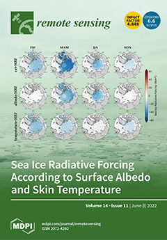
Cover Story (view full-size image):
Sea ice radiative forcing (SIRF) is the instantaneous perturbation of the Earth’s radiation at the top of the atmosphere (TOA) caused by sea ice. Previous studies focused only on the role of albedo on SIRF. Skin temperature is also closely related to sea-ice changes and is one of the main factors behind Arctic amplification. In this study, the net-SIRF was calculated by considering not only the albedo-SIRF, but also the temperature-SIRF. The albedo-SIRF and temperature-SIRF had similar effects on net-SIRF; however, there has been a rapid acceleration of changes in the temperature-SIRF compared to the albedo-SIRF. The SIRFs for each factor had different patterns depending on the season and region. This study indicates that skin temperatures may have a greater impact on the Arctic than albedo in terms of sea-ice surface changes. View this paper
- Issues are regarded as officially published after their release is announced to the table of contents alert mailing list.
- You may sign up for e-mail alerts to receive table of contents of newly released issues.
- PDF is the official format for papers published in both, html and pdf forms. To view the papers in pdf format, click on the "PDF Full-text" link, and use the free Adobe Reader to open them.
Previous Issue
Next Issue