You are currently viewing a new version of our website. To view the old version click .

Remote Sensing, Volume 13, Issue 7

April-1 2021 - 179 articles

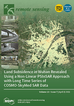
Cover Story: Wuhan is an important city in Central China, whose rapid development has led to increasingly serious land subsidence over the last few decades. In this study, we used nearly 300 high-resolution COSMO-SkyMed StripMap HIMAGE scenes acquired in 2012–2019 to monitor the long-term subsidence process and reveal its spatiotemporal variations. By combining the sequence of settlement curves in the subsiding area, the relationship between natural factors (soft soil consolidation, rainfall), human factors (subway construction, new urbanization, groundwater pumping), and ground deformation was discussed in detail. Our work unveils previously unknown characters of land subsidence in Wuhan and its causative factors, and also shows the benefits of non-linear PSInSAR to study the temporal evolution of such processes in dynamic and expanding cities. View this paper.
  • Issues are regarded as officially published after their release is announced to the table of contents alert mailing list .
  • You may sign up for email alerts to receive table of contents of newly released issues.
  • PDF is the official format for papers published in both, html and pdf forms. To view the papers in pdf format, click on the "PDF Full-text" link, and use the free Adobe Reader to open them.

Articles (179)

  • Article
  • Open Access
11 Citations
4,858 Views
17 Pages

5 April 2021

In this study, we analyze the influence of the Great East Japan Earthquake, which occurred on 11 March 2011, on the shoreline of the northern Ibaraki Coast. After the earthquake, the area experienced subsidence of approximately 0.4 m. Shoreline chang...

  • Article
  • Open Access
5 Citations
3,437 Views
18 Pages

5 April 2021

Photosynthesis and its sensitivity to the changing environment in alpine regions are of great significance to the understanding of vegetation–environment interactions and other global ecological processes in the context of global change, while their...

  • Article
  • Open Access
10 Citations
6,727 Views
15 Pages

5 April 2021

When flooding occurs, Synthetic Aperture Radar (SAR) imagery is often used to identify flood extent and the affected buildings for two reasons: (i) for early disaster response, such as rescue operations, and (ii) for flood risk analysis. Furthermore,...

  • Technical Note
  • Open Access
24 Citations
4,060 Views
11 Pages

4 April 2021

The high-frequency channel of lunar penetrating radar (LPR) onboard Yutu-2 rover successfully collected high quality data on the far side of the Moon, which provide a chance for us to detect the shallow subsurface structures and thickness of lunar re...

  • Article
  • Open Access
20 Citations
4,386 Views
18 Pages

4 April 2021

Ghosts are a common phenomenon widely present in unmanned aerial vehicle (UAV) remote sensing image stitching that seriously affect the naturalness of stitching results. In order to effectively remove ghosts and produce visually natural stitching res...

  • Article
  • Open Access
15 Citations
3,957 Views
30 Pages

4 April 2021

Ice phenology data of 22 large lakes of the Northern Hemisphere for 40 years (1979–2018) have been retrieved from passive microwave remote sensing brightness temperature (Tb). The results were compared with site-observation data and visual interpreta...

  • Article
  • Open Access
18 Citations
3,684 Views
15 Pages

A New Method for Determining an Optimal Diurnal Threshold of GNSS Precipitable Water Vapor for Precipitation Forecasting

  • Haobo Li,
  • Xiaoming Wang,
  • Suqin Wu,
  • Kefei Zhang,
  • Erjiang Fu,
  • Ying Xu,
  • Cong Qiu,
  • Jinglei Zhang and
  • Li Li

4 April 2021

Nowadays, precipitable water vapor (PWV) retrieved from ground-based Global Navigation Satellite Systems (GNSS) tracking stations has heralded a new era of GNSS meteorological applications, especially for severe weather prediction. Among the existing...

  • Article
  • Open Access
70 Citations
12,319 Views
25 Pages

Rice-Yield Prediction with Multi-Temporal Sentinel-2 Data and 3D CNN: A Case Study in Nepal

  • Ruben Fernandez-Beltran,
  • Tina Baidar,
  • Jian Kang and
  • Filiberto Pla

4 April 2021

Crop yield estimation is a major issue of crop monitoring which remains particularly challenging in developing countries due to the problem of timely and adequate data availability. Whereas traditional agricultural systems mainly rely on scarce groun...

  • Article
  • Open Access
9 Citations
3,689 Views
22 Pages

Mapping Surficial Soil Particle Size Fractions in Alpine Permafrost Regions of the Qinghai–Tibet Plateau

  • Chong Wang,
  • Lin Zhao,
  • Hongbing Fang,
  • Lingxiao Wang,
  • Zanpin Xing,
  • Defu Zou,
  • Guojie Hu,
  • Xiaodong Wu,
  • Yonghua Zhao and
  • Yu Sheng
  • + 4 authors

4 April 2021

Spatial information of particle size fractions (PSFs) is primary for understanding the thermal state of permafrost in the Qinghai-Tibet Plateau (QTP) in response to climate change. However, the limitation of field observations and the tremendous spat...

  • Article
  • Open Access
25 Citations
4,893 Views
25 Pages

Cereal Crops Soil Parameters Retrieval Using L-Band ALOS-2 and C-Band Sentinel-1 Sensors

  • Emna Ayari,
  • Zeineb Kassouk,
  • Zohra Lili-Chabaane,
  • Nicolas Baghdadi,
  • Safa Bousbih and
  • Mehrez Zribi

4 April 2021

This paper discusses the potential of L-band Advanced Land Observing Satellite-2 (ALOS-2) and C-band Sentinel-1 radar data for retrieving soil parameters over cereal fields. For this purpose, multi-incidence, multi-polarization and dual-frequency sat...

of 18

Get Alerted

Add your email address to receive forthcoming issues of this journal.

XFacebookLinkedIn
Remote Sens. - ISSN 2072-4292