


Abstract
Against the background of a warming and humidifying climate on the Qinghai–Tibet Plateau, increasing attention has been paid to the sustainability of water resources and ecosystems in the Qinghai Lake Basin. Investigating the characteristics of precipitation stable isotopes and moisture sources provides critical insights into the driving mechanisms of the regional hydrological cycle. In this study, precipitation samples collected at the Qinghai Lake Wetland Ecosystem National Observation and Research Station from June 2023 to October 2024 were analyzed for hydrogen (δ2H) and oxygen (δ18O) stable isotopes. The temporal variations of δ2H, δ18O, and deuterium excess (d-excess) were characterized, and their relationships with air temperature and precipitation amount were examined. In addition, a backward trajectory model was employed to identify the moisture sources of precipitation during the observation period. The results indicate that: (1) precipitation stable isotopes and d-excess exhibit pronounced seasonal variability, characterized by enrichment in summer and depletion in spring and autumn; (2) the Local Meteoric Water Line (LMWL) for the basin is defined as δ2H = 8.15δ18O + 38.71 (R2 = 0.93), with both slope and intercept exceeding those of the Global Meteoric Water Line (GMWL); (3) precipitation isotopes show a discernible temperature effect but are jointly controlled by multiple moisture sources and meteorological factors; and (4) backward trajectory analysis combined with d-excess values reveals that precipitation moisture is primarily derived from westerly transport, while locally recycled moisture and continental air masses also exert significant influences. Overall, these findings reveal the multi-source driving mechanisms of the regional hydrological cycle and provide critical scientific support for understanding hydrological processes in alpine inland basins and their responses to future climate change, thereby contributing to the sustainable management of regional water resources.
1. Introduction
Precipitation represents a fundamental input to terrestrial ecosystem hydrological processes. With ongoing global climate warming, precipitation over the Qinghai–Tibetan Plateau has shown an overall increasing trend, with an average increase of approximately 5.2 mm per decade. This increase is particularly pronounced in the northern part of the plateau [1,2]. Stable isotopes in precipitation serve as natural tracers that are highly sensitive to environmental changes. They provide valuable information on hydrological processes and can be effectively used to trace atmospheric moisture sources and transport pathways within the hydrological cycle [3].
Since 1961, the International Atomic Energy Agency (IAEA) and the World Meteorological Organization (WMO) have jointly established the Global Network of Isotopes in Precipitation (GNIP), which aims to systematically investigate the spatial distribution and temporal variations in precipitation stable isotopes worldwide [4]. Based on hydrogen and oxygen isotope data from precipitation, rivers, and lakes at more than 400 observation sites worldwide, Harmon Craig [5] first proposed the Global Meteoric Water Line (GMWL), expressed as δD = 8δ18O + 10. Subsequently, Willi Dansgaard [6], using GNIP monitoring data, demonstrated that the isotopic composition of precipitation is primarily controlled by factors such as latitude, elevation, temperature, precipitation amount, and distance from the ocean. He further identified several well-known controlling mechanisms, including the latitude effect, altitude effect, temperature effect, precipitation effect, and continental effect.
Research on precipitation isotopes in the Qinghai–Tibetan Plateau dates back to 1966, when Chinese scientific expeditions investigated the isotopic characteristics of snow and ice in the high-altitude regions of Mount Everest [7]. In 2004, China established the Chinese Network of Isotopes in Precipitation (CHNIP) to systematically monitor the characteristics of δD and δ18O in precipitation across the country [8]. In recent years, numerous studies based on GNIP and CHNIP observations have greatly improved the understanding of hydrogen and oxygen isotope variations in different regions and water bodies in China. In the Qinghai–Tibetan Plateau region, precipitation isotope studies have increasingly focused on temporal and spatial variations [9,10], environmental effects [11,12,13], and atmospheric moisture sources [14,15]. These studies cover a wide range of areas, including the eastern slope of the plateau [9], southern Tibet [16,17], the northern Tibetan Plateau [18], the source region of the Yangtze River [19], the source region of the Yellow River [20], the source region of the Nujiang River [21], and the Shule River headwaters [22]. Existing studies on precipitation stable isotopes in the Qinghai Lake Basin have primarily focused on the summer season. Jing et al. [15] analyzed precipitation isotope data collected during the summers (June–July) from 2012 to 2018 and revealed significant intraseasonal variability in δ18O and δ2H, as well as a significant positive correlation between δ18O and the El Niño–Southern Oscillation (ENSO) index. Wu et al. [23] collected event-based precipitation samples during summer, identifying temporal variations in stable isotope composition and further exploring the influences of atmospheric circulation and local moisture recycling on precipitation isotopes. Despite extensive studies on precipitation stable isotopes and moisture cycling across the Tibetan Plateau, high-temporal-resolution and continuous observational data of precipitation isotopes in the Qinghai Lake Basin remain relatively scarce in recent years. Consequently, the temporal variability of stable isotopes and their responses to environmental factors, such as air temperature and precipitation amount, are still insufficiently understood. In addition, quantitative assessments of the relative contributions from different moisture sources are still lacking.
The Qinghai Lake Basin is located in the northeastern Tibetan Plateau. Against the background of a warming and humidifying climate, the basin has experienced notable hydrological changes in recent years. During 2023–2024, the annual mean water level of Qinghai Lake increased cumulatively by 0.24 m, reaching 3196.84 m in 2024 [24]. Meanwhile, precipitation in the basin has increased at an average rate of 1.68 mm per year. As the primary water source of the lake, precipitation is jointly regulated by multiple moisture-related processes [25]. Among these processes, the relative contributions of enhanced oceanic moisture input and increased local moisture recycling induced by lake expansion remain unclear, and quantifying their respective roles in driving precipitation increases has become a key scientific issue in regional hydrological cycle research. Therefore, this study uses the Qinghai Lake Wetland Ecosystem National Observation and Research Station as a monitoring site to collect precipitation samples from June 2023 to October 2024. Hydrogen (δ2H) and oxygen (δ18O) stable isotopes were measured to systematically analyze the temporal variations in precipitation isotopic composition. Furthermore, the relationships between isotopic composition and meteorological factors (air temperature and precipitation amount) were examined, and backward trajectory modeling was employed to simulate moisture sources of precipitation. This study enhances the understanding of precipitation stable isotope characteristics and moisture sources and provides important insights into hydrological processes in alpine inland basins, thereby supporting the sustainable management of regional water resources.
2. Materials and Methods
2.1. Overview of the Study Area
The Qinghai Lake Basin is located in the northeastern Qinghai–Tibet Plateau, at the transitional zone between the arid regions of northwestern China, the Loess Plateau, and the alpine region of the Qinghai–Tibet Plateau. Characterized by high-altitude terrain and a typical semi-arid plateau continental climate, the basin is highly sensitive to climate change due to its unique geographical setting. The mean annual temperature ranges from −1.0 to 4.0 °C, while the annual precipitation varies between 291 and 579 mm. Precipitation exhibits strong seasonal variability, with more than 75% occurring during the wet season from May to September. In contrast, precipitation from October to February accounts for only 3–10% of the annual total, whereas that in March and April contributes approximately 15%, resulting in a distinct seasonal pattern of dry and wet periods [26].
2.2. Sample Collection and Analytical Methods
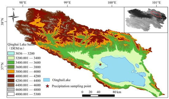
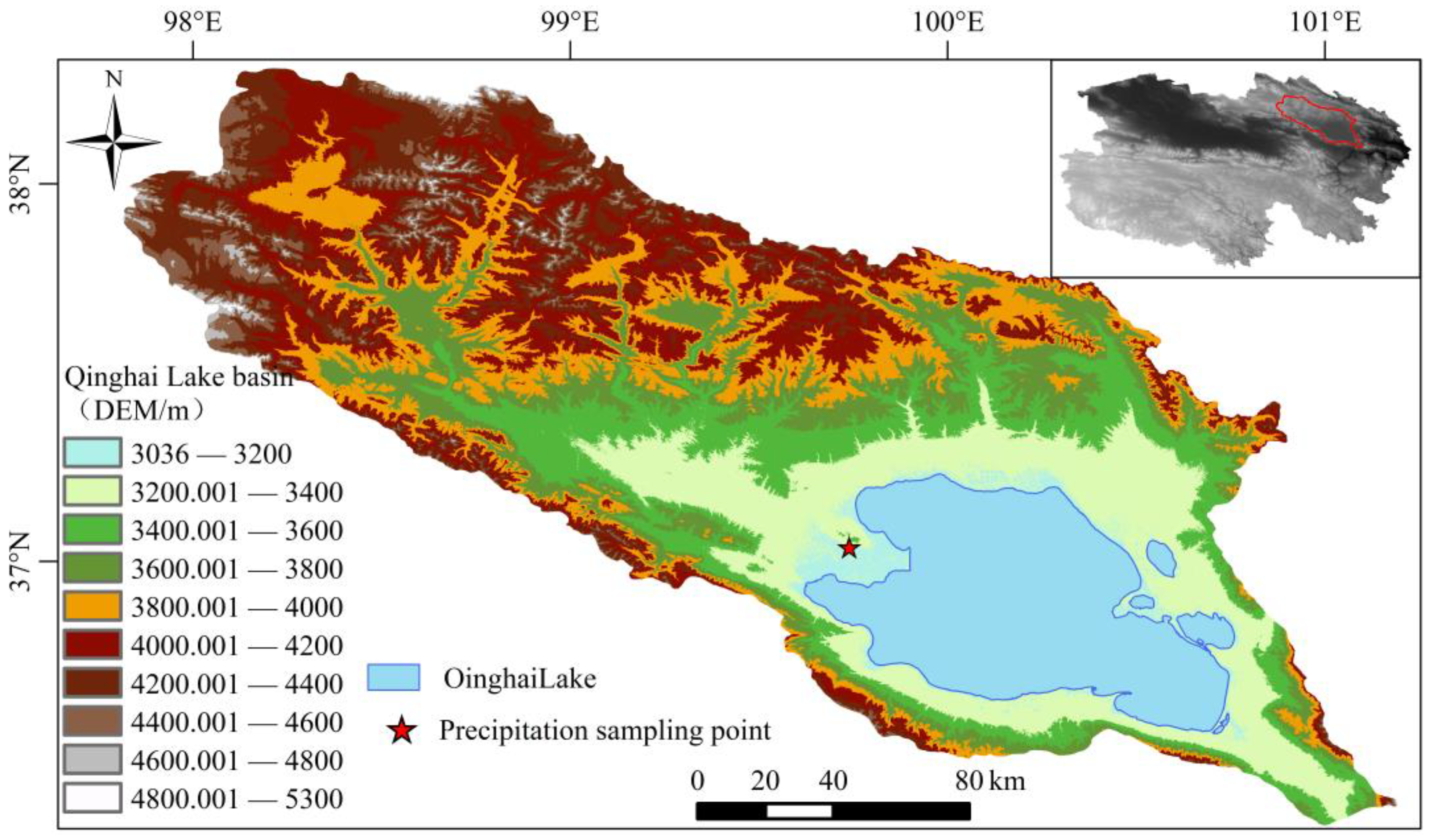
Precipitation samples were collected at the Qinghai Lake Wetland Ecosystem National Observation and Research Station (37.0368° N, 99.7391° E) (Figure 1) from June 2023 to October 2024. Sampling followed standard meteorological observation protocols, whereby all precipitation occurring between 20:00 on a given day and 20:00 on the following day was defined as a single precipitation event, and one corresponding sample was collected. Precipitation was collected using a custom-built sampling device consisting of a funnel and a conical flask. After each precipitation event, the collected water was transferred into 60 mL high-density polyethylene (HDPE) amber bottles. In total, 86 precipitation samples were obtained during the study period. It should be noted that from 1 December 2023 to 29 February 2024 (winter), the basin experienced cold and dry conditions, with only trace snowfall events (individual precipitation < 0.5 mm), all in solid form. Due to sampling limitations, no valid precipitation samples were obtained during winter. Therefore, this study focuses on isotopic characteristics and moisture source analysis for spring (March–May 2024), summer (June–August 2023 and 2024), and autumn (September–November 2023 and September–October 2024). All samples were sealed immediately after collection and transported to the laboratory for low-temperature storage. Prior to analysis, water was extracted using an automatic vacuum condensation extraction system (LI-2100, LICA Inc., Beijing, China) to avoid isotopic fractionation. The extracted samples were then transferred into 2 mL vials and sealed with Parafilm. Before measurement, samples were filtered through a 0.22 μm membrane filter. The δ2H and δ18O values were measured using a liquid water isotope analyzer (TLWIA-912, LGR Inc., Mountain View, CA, USA). During the analytical process, three standard samples were used for calibration, and measurements were conducted in a sequence of three unknown samples following each standard. Each analytical cycle consisted of 12 injections (3 standards and 9 samples), totaling 72 injections. At the end of each cycle, calibration curves were generated based on the standard samples to correct the measured values. Each sample was injected six times, with the first two injections discarded to eliminate potential memory effects. The average of the remaining four injections was used as the final isotopic value.
Figure 1.
Research area and the distribution of sampling points.
All isotopic results are reported in per mil (‰) relative to the Vienna Standard Mean Ocean Water (V-SMOW) standard [5]. The analytical precisions for δ18O and δ2H were ±0.05‰ and ±0.2‰, respectively. The isotopic compositions are expressed using the following equation:
where Rsample and RV-SMOW represent the isotopic ratios (2H/1H or 18O/16O) of the sample and the Vienna Standard Mean Ocean Water (V-SMOW) standard, respectively.
2.3. Meteorological Data
Meteorological data, including precipitation and air temperature, were obtained from the flux tower at the Qinghai Lake Wetland Ecosystem National Observation and Research Station. The flux tower is located approximately 500 m from the precipitation sampling site, ensuring good spatial representativeness of the observed meteorological variables.
2.4. Backward Trajectory Model
Atmospheric moisture transport pathways are commonly simulated using the Hybrid Single-Particle Lagrangian Integrated Trajectory (HYSPLIT) model developed by the National Oceanic and Atmospheric Administration (NOAA). In this study, meteorological input data were obtained from the Global Data Assimilation System (GDAS) provided by the National Centers for Environmental Prediction (NCEP), with a spatial resolution of 1° × 1°. The dataset includes key meteorological variables such as air pressure, wind speed, wind direction, temperature, and relative humidity. The Qinghai Lake Wetland Ecosystem National Observation and Research Station was selected as the trajectory endpoint, with an elevation of 3162 m. Considering that the maximum atmospheric moisture transport over China typically occurs at approximately 2000 m above ground level [27], the initial heights of air masses were set at 500 m, 1000 m, and 2000 m. The average residence time of water vapor in the troposphere was assumed to be 240 h [28], and a backward trajectory duration of 10 days (240 h) was adopted. This configuration allows for capturing continuous precipitation processes and improves the accuracy of identifying moisture source pathways. For each precipitation event, backward trajectories were calculated at 1 h intervals to trace moisture origins. Subsequently, the clustering module embedded in the HYSPLIT model was applied to group trajectories and quantify the relative contributions of different moisture transport pathways. Trajectory clustering analysis is based on grouping trajectories with similar spatial characteristics. The method calculates the mean trajectory by averaging the latitude and longitude positions weighted by the residence time at each hourly step [29]. The clustering process is further based on the calculation of spatial variance (SPVAR) and total spatial variance (TSV), which are used to classify all trajectories reaching the receptor site into distinct clusters. The SPVAR is calculated as follows:
where Dij represents the distance between the j-th hourly endpoint of the i-th trajectory and the corresponding point on the mean trajectory; t denotes the total trajectory duration; x represents the number of trajectories within a given cluster; and TSV (total spatial variance) is defined as the sum of SPVAR values across all clusters.
2.5. Data Analysis
Hydrogen and oxygen stable isotope data were first preprocessed using Microsoft Excel 2019. Statistical analyses were performed using SPSS 26, including Pearson correlation analysis and regression analysis to examine relationships between isotopic composition and meteorological variables. Figures illustrating the analytical results were generated using Origin 2025, while the spatial distribution map of the sampling site within the study area was produced using ArcGIS 10.2.
In this study, precipitation amount-weighted mean values of stable isotopes were calculated for the study period. This approach is based on the principle of isotope mass conservation and is expressed as follows:
where Pi represents the precipitation amount (mm) of the i-th event; δi denotes the corresponding δ18O, δ2H, or d-excess value (‰); and n is the total number of precipitation events. To avoid instability in weighting caused by extremely low precipitation amounts, events with precipitation < 0.5 mm were excluded from the calculation. A total of 79 precipitation events were retained for the weighted analysis.
3. Results
3.1. Characteristics of Stable Isotopes in Precipitation
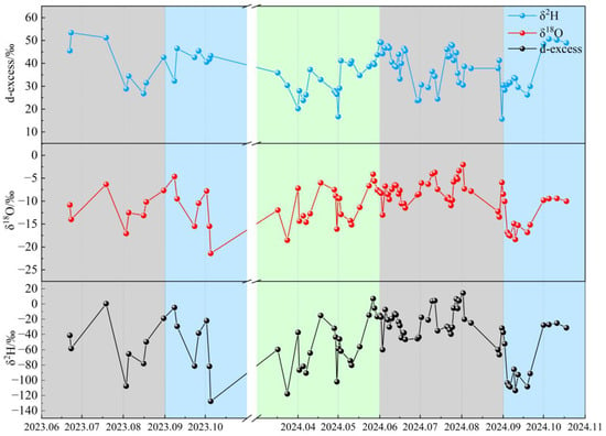
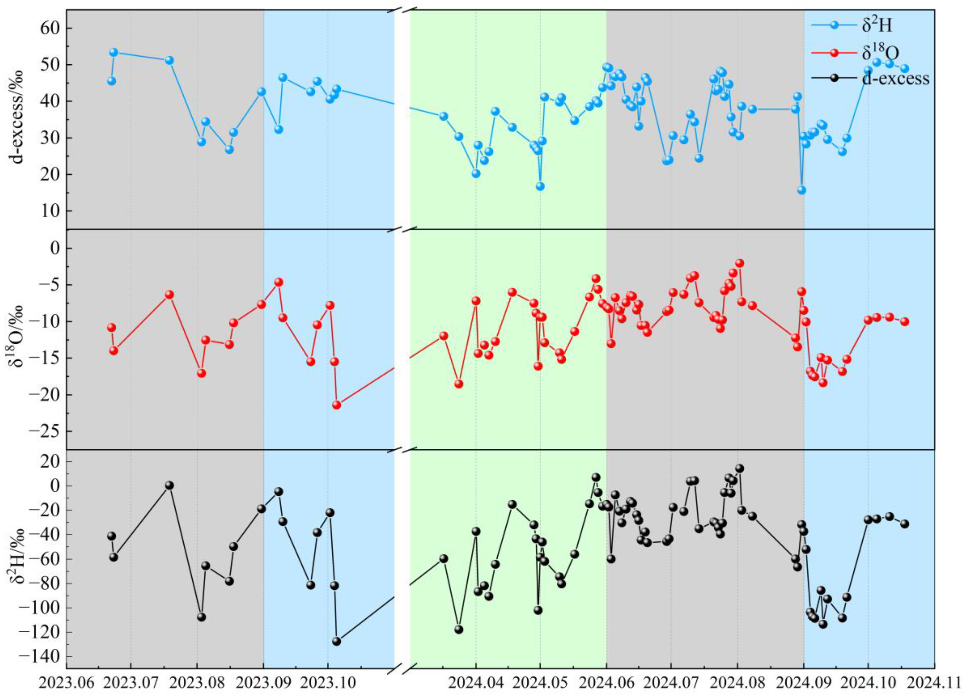
During the study period, a total of 86 precipitation samples were collected, with precipitation mainly concentrated from June to September. The temporal variations in precipitation stable isotopes are shown in Figure 2. The δ2H values ranged from −127.7‰ to 14.34‰, with an amount-weighted mean of −42.52‰ and a standard deviation of 33.68‰. The δ18O values ranged from −21.37‰ to −2.01‰, with an amount-weighted mean of −10.01‰ and a standard deviation of 4.02‰. On the temporal scale, precipitation stable isotopes exhibited pronounced fluctuations, reflecting differences in moisture sources and atmospheric processes among individual precipitation events. Overall, δ2H and δ18O values in the Qinghai Lake Basin were relatively low. This pattern is closely related to the high-altitude and semi-arid climatic conditions of the study area. In the basin, annual evaporation exceeds precipitation, and isotopic fractionation is likely to occur during both precipitation formation and falling processes, resulting in the depletion of heavy isotopes in precipitation [30]. In addition, lower temperatures in high-altitude regions enhance isotopic fractionation during moisture transport and condensation, further contributing to the relatively depleted isotopic composition of precipitation. At the national scale, precipitation stable isotopes in China exhibit a wide range, with δ2H values ranging from −210‰ to 20‰ and δ18O values ranging from −24‰ to 2‰ [31]. The δ2H and δ18O values observed in the Qinghai Lake Basin fall within this national range but are generally skewed toward the lower end.
Figure 2.
Temporal variations in precipitation δ2H, δ18O, and d-excess in the Qinghai Lake Basin. Note: Unshaded areas represent periods without observational data.
The stable isotopes of precipitation in the Qinghai Lake Basin exhibit clear seasonal variability, characterized by relative enrichment in summer and depletion in spring and autumn. This pattern is generally consistent with the temporal variation in precipitation isotopes observed across the Tibetan Plateau. The enrichment of isotopes in summer precipitation is closely related to locally evaporated moisture and moisture transported from northern regions [32]. Higher temperatures during summer enhance evaporation from lakes and land surfaces, and water vapor generated from the evaporation of Qinghai Lake is incorporated into the local atmospheric circulation, participating in precipitation formation and leading to relatively enriched isotopic values. In contrast, precipitation isotopes during spring and autumn are relatively depleted. Precipitation formed from oceanic air masses generally exhibits lower isotopic values [33], suggesting that moisture during these periods is primarily derived from long-distance transport of oceanic vapor. Previous studies conducted in the adjacent Heihe River Basin have reported similar seasonal patterns, with higher isotope values in summer compared to other seasons [34], which is consistent with the findings of this study. At the daily scale, precipitation isotopes also show pronounced variability. On 2 August 2024, isotopic values reached a maximum (δ2H = 14.34‰ and δ18O = −2.01‰), which may be attributed to a small precipitation event (1.1 mm) combined with relatively high temperatures (16.2 °C), resulting in strong sub-cloud evaporation during raindrop descent and consequent isotopic enrichment. In contrast, continuous precipitation from 1 to 10 September 2024 produced a dilution effect. In addition, interactions between raindrops and ambient atmospheric moisture during descent further contributed to the progressive depletion of δ2H and δ18O values in precipitation [34].
Dansgaard [6] defined the deuterium excess (d-excess) parameter of precipitation as d-excess = δ2H − 8δ18O, which is commonly used to indicate the degree of deviation from isotopic equilibrium caused by kinetic fractionation during moisture evaporation. In the Qinghai Lake Basin, d-excess values ranged from 15.67‰ to 53.39‰, with an amount-weighted mean of 37.55‰ and a standard deviation of 8.62‰. The d-excess values in the study area are generally high and significantly exceed the global average of approximately 10‰, indicating strong kinetic fractionation effects during moisture evaporation. From a seasonal perspective, d-excess exhibits clear variability, with higher values in summer and relatively lower values in spring and autumn. The maximum d-excess values occur in summer, which is consistent with the temporal variations observed for δ2H and δ18O.
3.2. Relationship Between δ18O and δ2H in Precipitation
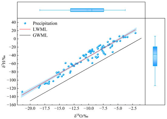
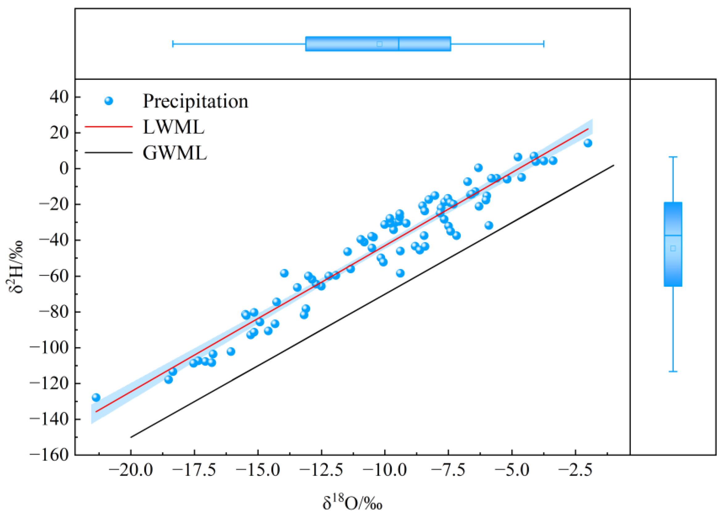
Craig [5] proposed the Global Meteoric Water Line (GMWL) based on the linear relationship between δ2H and δ18O in precipitation, expressed as δ2H = 8δ18O + 10. In this relationship, the slope reflects the fractionation relationship between δ2H and δ18O, while the intercept represents the deviation of deuterium excess (d-excess) from isotopic equilibrium conditions [35]. Due to variations in climatic conditions and atmospheric circulation patterns, the relationship between δ2H and δ18O differs across regions, resulting in the formation of Local Meteoric Water Lines (LMWLs). Based on precipitation isotope data from the Qinghai Lake Basin, the LMWL was established as δ2H = 8.15δ18O + 38.71 (R2 = 0.93) (Figure 3). Compared with the GMWL (δ2H = 8δ18O + 10), both the slope and intercept of the LMWL in the study area are notably higher. This pattern can be attributed to multiple processes. During long-distance transport of moisture into the interior of the Tibetan Plateau, repeated in-cloud condensation leads to progressive depletion of heavy isotopes, thereby increasing the intercept. Meanwhile, the relatively low air temperature at high altitudes, combined with strong evaporation from Qinghai Lake and relatively high humidity, results in weak sub-cloud evaporation, which contributes to a slightly higher slope than the global average [36]. In addition, the Tibetan Plateau is influenced by multiple moisture sources and a continental climate, leading to pronounced spatial variability in precipitation isotopes. Previous studies have shown that both the slope and intercept of meteoric water lines tend to increase with latitude [37]. As the study area is located in an arid to semi-arid region, evaporation processes exert a significant influence on isotopic composition. Limited precipitation, short rainfall duration, and dry atmospheric conditions enhance pre-condensation evaporation, causing deviations from isotopic equilibrium and contributing to the elevated slope and intercept of the LMWL [22]. Furthermore, strong evaporation from the lake surface intensifies regional moisture recycling, further influencing the isotopic composition of precipitation in terms of both hydrogen and oxygen isotopes.
Figure 3.
Meteoric water line of precipitation in the Qinghai Lake Basin.
Seasonal variations in the meteoric water line were further analyzed (Table 1). The results show that the slopes of the meteoric water lines for different seasons decrease in the following order: autumn (k = 8.87) > spring (k = 8.22) > summer (k = 6.68). Similarly, the intercepts follow the order: autumn (b = 49.74) > spring (b = 34.83) > summer (b = 28.38). The slope of the summer meteoric water line (6.68) is significantly lower than that of the Global Meteoric Water Line proposed by Harmon Craig, while its intercept is also relatively low. This indicates that precipitation during summer is strongly affected by evaporation during its formation and falling processes. Such characteristics are closely related to the relatively high air temperature, intense evaporation, and local moisture recycling in the Qinghai Lake Basin during summer. Previous studies have shown that in arid and semi-arid regions with strong evaporation, the slope and intercept of the meteoric water line generally decrease as evaporation intensity increases [38]. In addition, precipitation formation in the basin during summer may be influenced by locally evaporated water vapor, and secondary evaporation processes during raindrop descent may further reduce the slope of the meteoric water line. In contrast, the autumn meteoric water line shows a higher slope (8.87) and intercept (49.74) than those observed in spring and summer. This suggests that evaporation effects during precipitation formation are relatively weak in autumn, and the moisture sources are more likely to be dominated by long-distance transport. Meanwhile, enhanced cold air activity during this season may strengthen equilibrium fractionation processes during precipitation formation. The slope (8.22) and intercept (34.83) of the spring meteoric water line fall between those of summer and autumn. This indicates that precipitation during spring is influenced both by moisture transported by the westerlies and by a certain degree of local evaporation. Overall, the seasonal variations in the slope and intercept of meteoric water lines in the Qinghai Lake Basin reflect the combined influence of regional climatic conditions, evaporation intensity, and seasonal differences in moisture sources. The relatively low slope and intercept in summer highlight the important role of evaporative processes in isotopic fractionation, whereas the higher values observed in spring and autumn suggest weaker evaporation effects during precipitation formation.
Table 1.
Seasonal slopes and intercepts of the Local Meteoric Water Line (LMWL) in the Qinghai Lake Basin.
3.3. Backward Trajectory Cluster Analysis
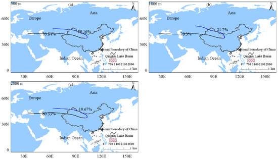
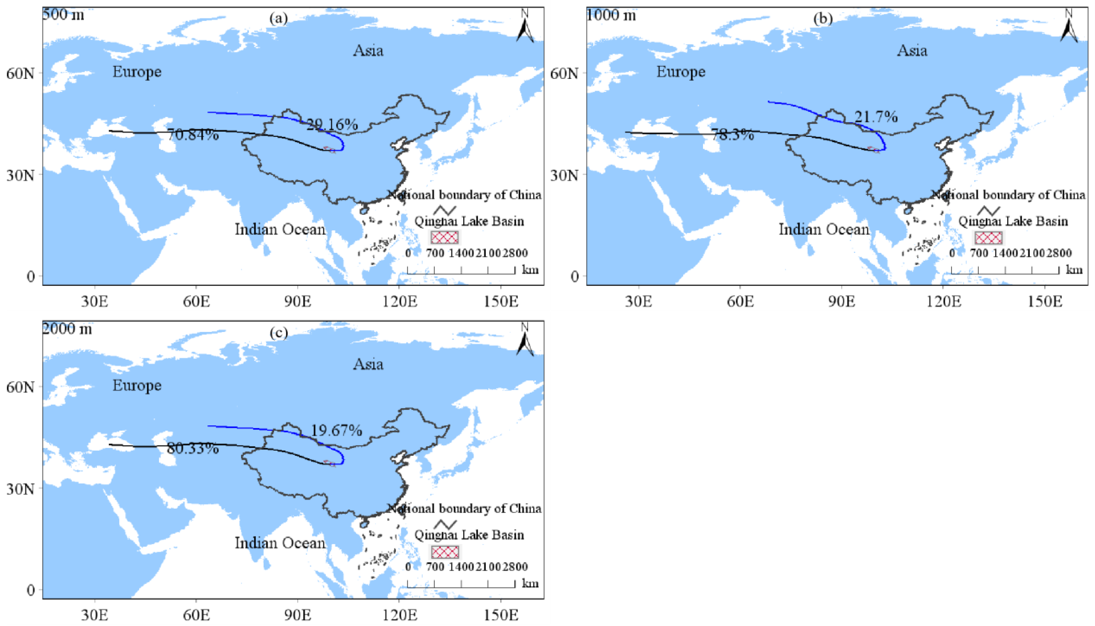
To analyze seasonal variations in moisture transport, backward trajectories of precipitation events were clustered separately for each season. The clustering results for spring (March–May 2024) are shown in Figure 4. At initial heights of 500 m, 1000 m, and 2000 m, moisture transported by the westerlies dominated the precipitation moisture sources, accounting for 70.84%, 78.30%, and 80.33% of the total, respectively. In contrast, moisture originating from long-distance transport along northern pathways contributed 29.16%, 21.70%, and 19.67%, respectively.
Figure 4.
Cluster analysis of backward trajectories of moisture sources during spring. Note: (a) Trajectory clustering based on initial heights at 500 m; (b) Trajectory clustering based on initial heights at 1000 m; (c) Trajectory clustering based on initial heights at 2000 m.
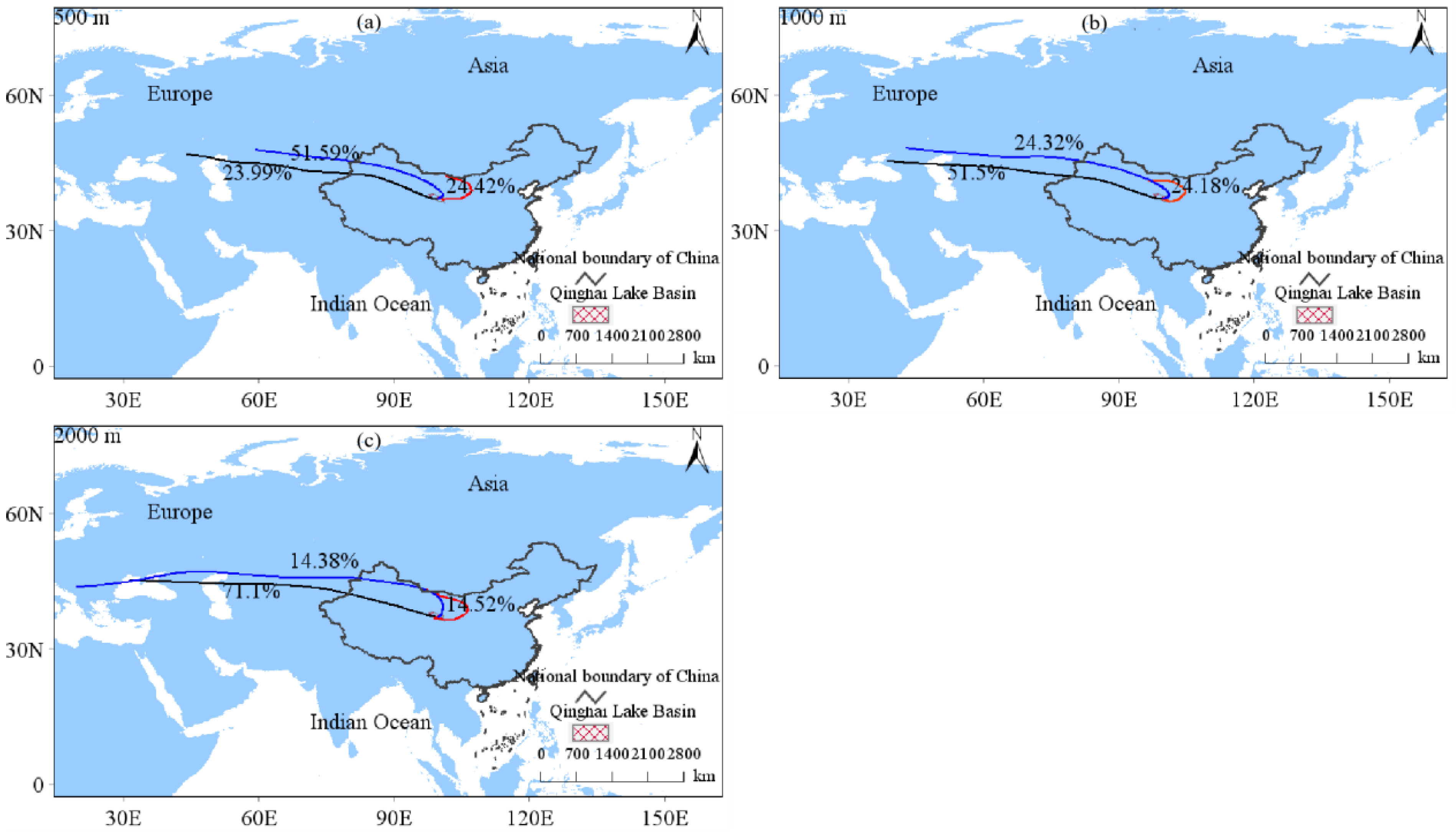
The clustering results of backward trajectories for summer precipitation (June–August 2023 and June–August 2024) are shown in Figure 5. At initial heights of 500 m, 1000 m, and 2000 m, moisture transported by the westerlies accounted for 23.99%, 51.50%, and 71.10% of the total, respectively. Moisture transported along long-distance northern pathways contributed 51.59%, 24.32%, and 14.38%, respectively, while locally recycled moisture accounted for 24.42%, 24.18%, and 14.52%, respectively.
Figure 5.
Cluster analysis of backward trajectories of moisture sources during summer. Note: (a) Trajectory clustering based on initial heights at 500 m; (b) Trajectory clustering based on initial heights at 1000 m; (c) Trajectory clustering based on initial heights at 2000 m.
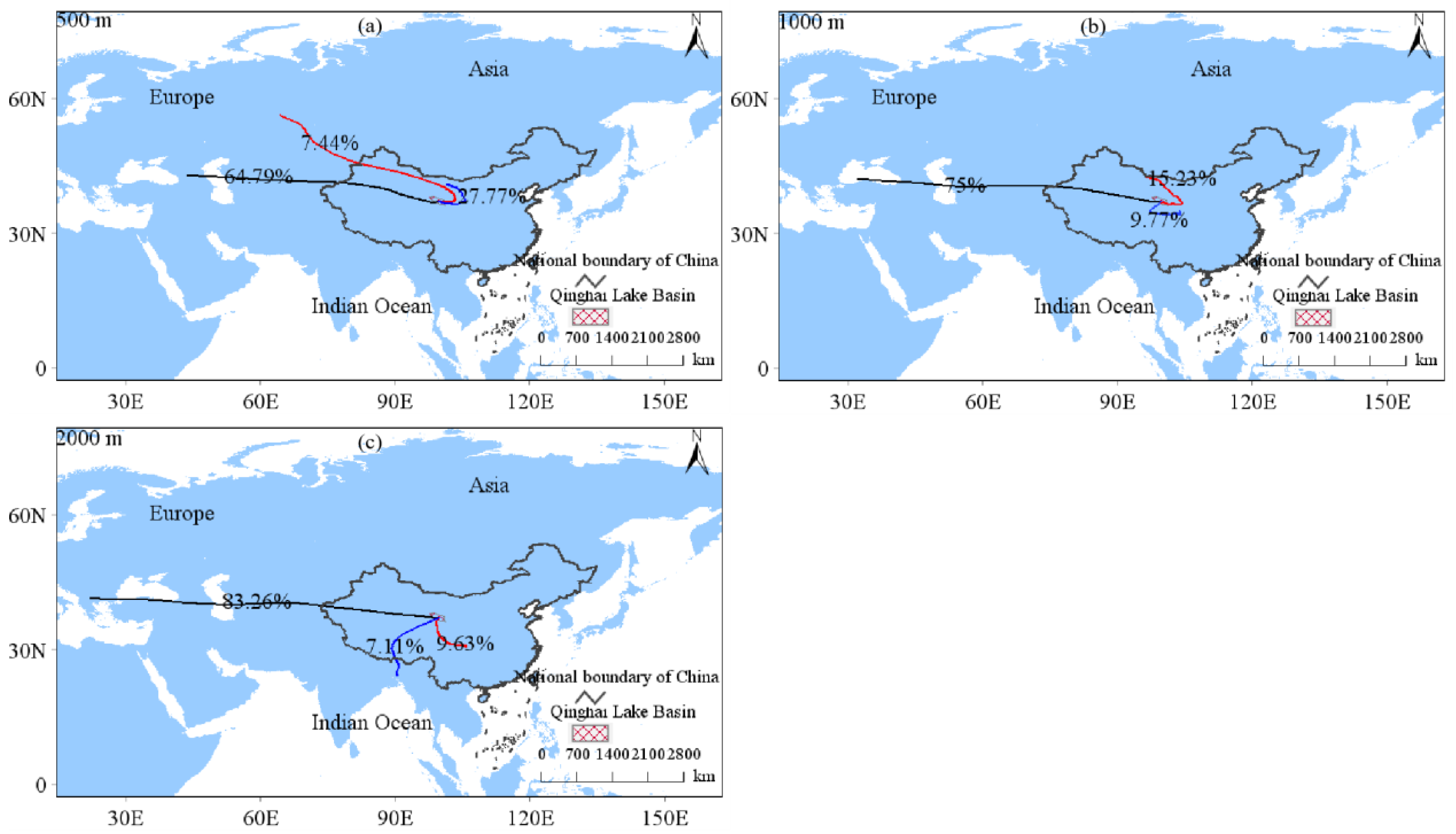
The clustering results of backward trajectories for autumn precipitation (September–October 2023 and September–October 2024) are shown in Figure 6. At initial heights of 500 m, 1000 m, and 2000 m, moisture transported by the westerlies accounted for 64.79%, 75.00%, and 83.26% of the total, respectively, indicating a dominant contribution from westerly airflow. At 500 m, moisture from long-distance northern pathways and locally recycled sources contributed 7.44% and 27.77%, respectively. At 1000 m, moisture transported via short-distance northern pathways accounted for 15.23%, while locally recycled moisture contributed 9.77%. At 2000 m, moisture associated with the Indian monsoon and East Asian monsoon contributed 7.11% and 9.63%, respectively. The backward trajectory clustering results were generally consistent across different initial heights (500 m, 1000 m, and 2000 m) during spring and summer, while some differences were observed in autumn. However, the dominant moisture transport pathways remained consistent, indicating that the results of this study are robust to the selection of trajectory starting heights.
Figure 6.
Cluster analysis of backward trajectories of moisture sources during autumn. Note: (a) Trajectory clustering based on initial heights at 500 m; (b) Trajectory clustering based on initial heights at 1000 m; (c) Trajectory clustering based on initial heights at 2000 m.
4. Discussion
4.1. Environmental Effects on Precipitation Stable Isotopes
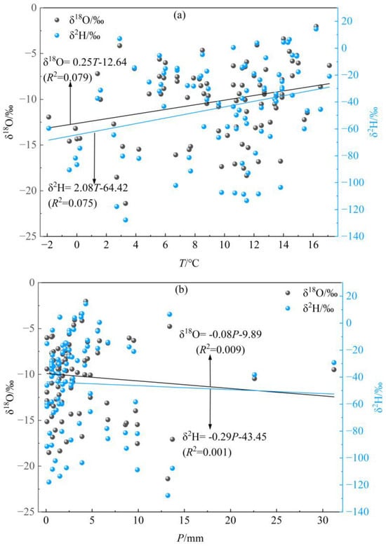
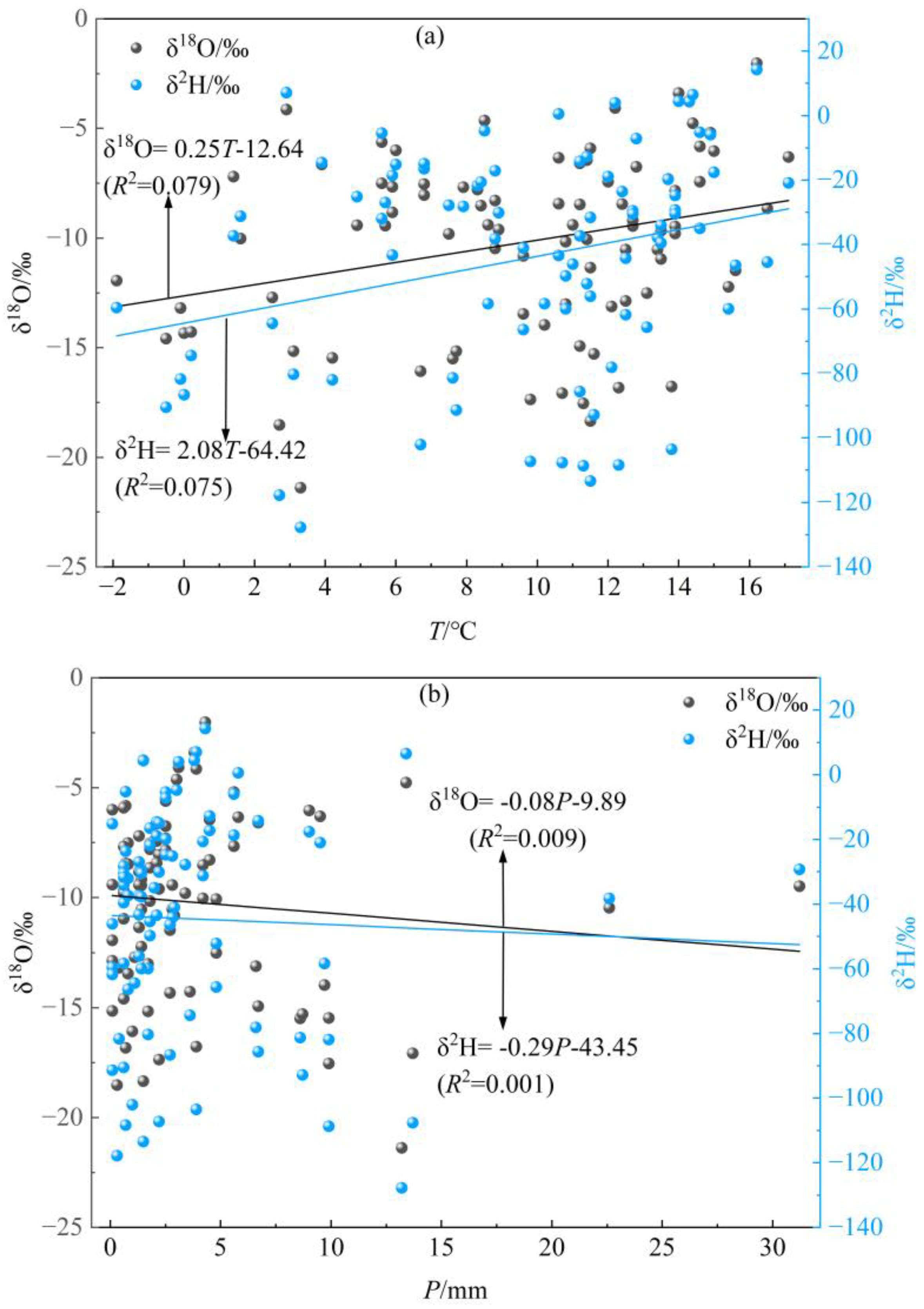
The isotopic composition of precipitation is closely related to environmental factors, with major controlling variables including moisture source, precipitation amount, temperature, and altitude [6]. Among these factors, air temperature is generally considered one of the most important controls on the variability of precipitation stable isotopes. The condensation temperature of cloud masses in the upper atmosphere is largely influenced by surface air temperature; therefore, a close relationship exists between air temperature and the isotopic composition of precipitation [39]. To clarify the relationship between precipitation stable isotopes and air temperature in the Qinghai Lake Basin, a correlation analysis between isotope values and temperature was conducted (Figure 7a). The results show that both δ2H and δ18O values exhibit an enrichment trend with increasing temperature. Specifically, δ2H increases by 2.08‰ and δ18O increases by 0.25‰ for every 1 °C rise in temperature, with coefficients of determination (R2) of 0.075 and 0.079, respectively. Both δ2H and δ18O show positive correlations with temperature (p < 0.05). However, the relatively low R2 values indicate limited explanatory and predictive power of the regression models. This suggests that, although temperature exerts a measurable influence on precipitation isotopes, it is not the sole controlling factor governing the isotopic composition of δ2H and δ18O. Nevertheless, the precipitation isotopes in the Qinghai Lake Basin exhibit a clear temperature effect. This finding is consistent with previous studies conducted in nearby regions, such as Zhangye Station [40] and the upper reaches of the Heihe River [27], where a significant temperature effect on precipitation isotopes has also been reported.
Figure 7.
Relationships between precipitation stable isotopes and meteorological factors (air temperature and precipitation amount) in the Qinghai Lake Basin. Note: (a) The relationship between stable isotopes in precipitation and air temperature; (b) The relationship between stable isotopes in precipitation and precipitation amount.
Precipitation amount is another important factor influencing stable isotopes in precipitation. In the Qinghai Lake Basin, precipitation exhibits clear seasonal variability, with higher amounts in summer and lower amounts in winter. To investigate the relationship between precipitation isotopes and precipitation amount, correlation analysis was conducted (Figure 7b). During the study period, δ2H and δ18O showed a slight depletion trend with increasing precipitation. Specifically, δ2H decreased by 0.29‰ and δ18O decreased by 0.08‰ for each 1 mm increase in precipitation, with coefficients of determination (R2) of 0.001 and 0.009, respectively. However, neither δ2H nor δ18O exhibited a statistically significant correlation with precipitation amount (p > 0.05), indicating the absence of a pronounced precipitation amount effect. This weak relationship may be attributed to the combined influences of short-term meteorological variability, local temperature differences, and the complexity of moisture sources [41]. The results are consistent with previous studies in inland regions [40], confirming that the precipitation amount effect is generally weak in arid and semi-arid inland areas of northern China.
To further clarify the relationships between precipitation δ2H, δ18O, temperature, and precipitation amount in the Qinghai Lake Basin, partial correlation analyses were conducted. Specifically, δ2H and δ18O were separately analyzed against temperature and precipitation amount. When controlling for temperature, the partial correlation coefficients between precipitation amount and δ2H and δ18O were −0.084 (p = 0.446) and −0.144 (p = 0.188), respectively, both of which were not statistically significant. This indicates that, after removing the influence of temperature, precipitation amount exerts only a weak effect on the isotopic composition of precipitation. Conversely, when controlling for precipitation amount, the partial correlation coefficients between temperature and δ2H and δ18O were 0.283 (p = 0.090) and 0.301 (p = 0.005), respectively. The correlation between temperature and δ18O reached statistical significance (p < 0.05), further highlighting the stronger influence of temperature compared to precipitation amount. To further quantify the combined effects of temperature and precipitation amount on δ2H and δ18O, a multiple linear regression model was applied to fit their relationships, and the resulting regression equations are presented as follows:
The regression results indicate that the influence of temperature on precipitation stable isotopes is substantially greater than that of precipitation amount. In the Qinghai Lake Basin, temperature emerges as the dominant controlling factor governing variations in δ2H and δ18O, whereas the precipitation amount effect is relatively weak. To some extent, the strong temperature effect may obscure the influence of precipitation amount on isotopic variability. This finding is consistent with the general patterns observed in high-altitude and high-latitude regions. Previous studies have demonstrated that precipitation isotopes in such environments are primarily controlled by temperature. This is because temperature directly influences the degree of isotopic fractionation during vapor condensation processes, resulting in increased enrichment of heavy isotopes in precipitation with rising temperature [42].
During the study period, δ2H and δ18O in precipitation from the Qinghai Lake Basin exhibited significant correlations with temperature but no significant relationships with precipitation amount. However, the relatively low coefficients of determination (R2) obtained from the regression models suggest limited explanatory and predictive power when using individual meteorological variables. These results indicate that the isotopic composition of precipitation in the study area is jointly influenced by multiple factors, including temperature, precipitation amount, relative humidity, and moisture sources, and thus cannot be adequately explained by any single environmental variable. Previous studies have similarly demonstrated that the weak correlations between precipitation isotopes and individual meteorological parameters are partly related to the limited length of observational records, as well as the inherent complexity and variability of controlling factors [43]. The Qinghai Lake Basin, located in the inland region of northwestern China, is influenced by multiple moisture sources, including warm and humid air masses transported from the North Atlantic, monsoonal moisture, dry polar air masses, and locally recycled vapor from the lake surface [40]. In addition, the pronounced temporal heterogeneity of hydrothermal conditions in this inland basin further enhances the complexity of isotopic composition and fractionation processes in precipitation.
4.2. Moisture Source Analysis
Deuterium excess (d-excess) contains critical information on moisture sources and serves as an important tracer for identifying the origin of precipitation isotopes [6]. In the Qinghai Lake Basin, the mean d-excess value was 37.02‰, which is substantially higher than the typical average (10‰) observed in inland regions of northwestern China. This elevated d-excess can be attributed to multiple processes. On the one hand, it reflects the contribution of locally recycled moisture, as evaporation from Qinghai Lake enhances d-excess values during the local moisture recycling process [44]. On the other hand, it may result from the interaction between oceanic moisture transported over long distances and locally evaporated vapor, which can intensify convective processes and modify isotopic signatures [45]. In high-altitude regions, some precipitation events may occur in solid form, and the formation and subsequent sublimation processes can introduce significant kinetic fractionation effects, leading to elevated d-excess values. For low-precipitation events, partial re-evaporation may occur during sample collection or transfer. In addition, a certain degree of measurement uncertainty may arise during instrumental analysis. Therefore, a precipitation amount-weighted mean approach was adopted in this study, and events with precipitation amounts less than 0.5 mm were excluded to minimize their potential influence on d-excess values. The large variation range of d-excess (up to 37.72‰) further indicates the complexity of moisture sources, as well as the variability in evaporation conditions and precipitation processes over the study area. Previous studies have shown that moisture originating from high-latitude continental evaporation typically exhibits d-excess values greater than 10‰, whereas moisture derived from low-latitude oceanic sources generally has d-excess values lower than 10‰ [46]. Therefore, the relatively high d-excess values observed in this study suggest a dominant continental characteristic of moisture sources in the Qinghai Lake Basin. In addition, evaporation from the lake surface and surrounding soils contributes locally recycled vapor to the atmospheric system, further elevating d-excess values. On the Tibetan Plateau, d-excess is also widely used as an indicator of large-scale atmospheric circulation. Higher d-excess values generally imply a stronger influence of westerly moisture transport, whereas monsoonal contributions are relatively weaker [47]. Previous studies have shown that the mean d-excess value of precipitation in the Muztagh region is 25.9‰, which is slightly lower than that observed in the Qinghai Lake Basin. When moisture is transported over long distances from regions such as the Mediterranean or the North Atlantic via the westerlies, d-excess values tend to increase significantly [48]. Therefore, the relatively high d-excess values in the Qinghai Lake Basin not only reflect the influence of local moisture recycling processes but also indicate that long-distance moisture transport by the westerlies plays an important role in precipitation formation in this region.
Due to the complexity of atmospheric processes, uncertainties remain when using hydrogen and oxygen isotopes alone to identify moisture transport pathways [49]. Therefore, combining isotopic observations with backward trajectory analysis provides a more robust approach for determining regional moisture sources. In this study, a backward trajectory model was applied to analyze the moisture transport pathways of precipitation in the Qinghai Lake Basin. Overall, the results indicate that precipitation moisture in the study area is predominantly derived from long-distance transport associated with the westerlies. In addition, contributions from locally evaporated moisture in the northwestern inland region, as well as long-range transport from northern pathways, also play supplementary roles in the regional moisture supply.
In spring, precipitation is jointly influenced by westerly air masses and continental air masses. As the initial height of air masses increases, the contribution of continental air masses transported along northern pathways decreases. Continental air masses are generally more stable and are associated with fewer precipitation events along their transport pathways [50], resulting in relatively limited progressive rainout of heavy isotopes. Consequently, isotopic fractionation during precipitation formation over the Qinghai Lake Basin is relatively weak. Spring d-excess values are comparatively low, with an amount-weighted mean of 32.54‰. Moisture originating from central and northern Asia is typically sourced from relatively dry regions, and the lower temperatures during spring at high elevations suppress secondary evaporation effects. As a result, d-excess values in spring are generally lower than those in summer and autumn. In summer, precipitation is primarily controlled by westerly air masses, with a significant contribution from locally recycled moisture. Moisture sources include long-distance Atlantic-origin vapor transported by the westerlies and short-distance locally evaporated vapor. Backward trajectory simulations indicate that, at an initial height of 500 m, locally recycled moisture accounts for up to 24.42% of the total contribution. Summer d-excess values are relatively high, with an amount-weighted mean of 40.31‰, exceeding those in spring and autumn. Elevated temperatures enhance surface evaporation, and evaporated water vapor inherently exhibits higher d-excess values. When this locally evaporated vapor mixes with atmospheric moisture, it significantly increases the d-excess of air masses. Moreover, evaporation from Qinghai Lake accounts for approximately 60–65% of the annual total during summer, further intensifying local moisture recycling and increasing the complexity of precipitation isotopic characteristics. In autumn, precipitation moisture is still dominated by westerly transport of Atlantic-origin vapor, with contributions exceeding 60% at initial heights of 500 m, 1000 m, and 2000 m. At higher altitudes (2000 m), additional influences from the Indian monsoon and the East Asian monsoon are observed, although their overall contributions remain limited. During long-distance transport, oceanic moisture undergoes multiple precipitation events with limited replenishment, leading to progressive depletion of heavy isotopes due to rainout processes, and consequently lower δ2H and δ18O values in autumn precipitation. Despite this depletion, autumn d-excess values remain relatively high, with an amount-weighted mean of 39.14‰, slightly lower than in summer. At an initial height of 500 m, the combined contribution of continental evaporation and locally recycled moisture reaches 35.22%, indicating a substantial influence of surface evaporation and local recycling. During transport, air masses are continuously supplemented by evaporated moisture from the underlying surface, which contributes to elevated d-excess values.
The consistency between the moisture source simulations and the elevated deuterium excess (d-excess) values jointly indicates that precipitation in the Qinghai Lake Basin is strongly controlled by westerly moisture transport. At the same time, moisture originating from low-altitude source regions is significantly influenced by local evaporation processes.
The Qinghai Lake Basin is located north of 35°N. Previous studies have classified regions north of 35°N on the Tibetan Plateau as dominated by the westerlies [51], indicating that the study area represents a typical westerly-controlled region. Oceanic moisture transported by the westerlies undergoes substantial evaporation under arid continental climatic conditions, leading to elevated d-excess values in precipitation. Previous studies have also demonstrated that the Qinghai Lake Basin is primarily influenced by westerly circulation [52], which is consistent with the findings of this study. In addition, nearby regions, including the Qilian Mountains [37], the upper reaches of the Heihe River [27], and the Muztagh Ata area [48], have also been shown to be predominantly influenced by westerly moisture transport.
In summary, during the study period, precipitation moisture in the Qinghai Lake Basin was predominantly controlled by westerly air masses. The primary moisture source was Atlantic-origin vapor transported by the westerlies across the Eurasian continent. During the transport process, locally recycled moisture from continental evaporation played a significant modulatory role in shaping the composition of precipitation moisture, thereby further influencing the stable isotopic characteristics of precipitation in the study area. This study improves the understanding of westerly-dominated moisture transport and local moisture recycling processes, providing important scientific support for enhancing the sustainability of hydrological systems under future climate change.
Despite the new insights obtained from continuous observations of precipitation stable isotopes from June 2023 to October 2024, several limitations and uncertainties remain in this study. First, the relatively short observation period and the use of a single sampling site constrain the ability to capture interannual variability and spatial heterogeneity of the regional climate system. The Qinghai Lake Basin is strongly influenced by large-scale atmospheric circulation patterns, and interannual climate variability, such as the El Niño–Southern Oscillation (ENSO), can substantially alter precipitation patterns, moisture transport pathways, and isotope fractionation processes. Therefore, analyses based on a single-year dataset may introduce systematic biases associated with anomalous climatic conditions, limiting the ability to quantify interannual variability and to disentangle the relative contributions of different climatic drivers to isotopic variations. Second, the identification of moisture transport pathways and the quantification of source contributions are subject to uncertainties arising from both the limited observation period and the inherent assumptions of the backward trajectory approach. The results presented in this study primarily reflect the characteristics of precipitation isotopes and moisture sources during the observation period and may not fully represent long-term variability. In addition, uncertainties in meteorological input data resolution and model parameterization within the trajectory model may further affect the accuracy of moisture source attribution.
Despite the aforementioned limitations, this study provides important scientific evidence for understanding hydrological processes in the Qinghai Lake Basin. The dataset comprehensively covers both the precipitation-intensive wet season and key non-rainy periods, yielding recent high-temporal-resolution observations of precipitation stable isotopes in the basin. Based on these observations, this study systematically characterizes the seasonal variability of isotopic composition and elucidates its responses to local environmental factors. Furthermore, the major moisture transport pathways during the observation period were identified through trajectory simulations. These findings fill the gap in recent observational data for the Qinghai Lake Basin and provide a solid empirical foundation for future investigations into regional hydrological processes and atmospheric moisture transport mechanisms.
5. Conclusions
(1) The δ2H values of precipitation in the Qinghai Lake Basin ranged from −127.7‰ to 14.34‰, with an amount-weighted mean of −42.52‰, while δ18O values ranged from −21.37‰ to −2.01‰, with an amount-weighted mean of −10.01‰. The stable isotopes exhibited pronounced seasonal variability, characterized by enrichment in summer and relative depletion in autumn. The mean d-excess value was significantly higher than the global average (10‰), indicating that precipitation moisture in the study area is primarily influenced by westerly-derived vapor and local moisture recycling. The Local Meteoric Water Line (LMWL) for the basin was defined as δ2H = 8.15δ18O + 38.71 (R2 = 0.93), with both slope and intercept exceeding those of the Global Meteoric Water Line (GMWL), reflecting the combined effects of regional climatic conditions and moisture source characteristics.
(2) Precipitation δ2H and δ18O values in the Qinghai Lake Basin exhibited enrichment with increasing air temperature, with δ2H and δ18O increasing by 2.08‰ and 0.25‰ per 1 °C rise, respectively. In contrast, both isotopes showed a depletion trend with increasing precipitation amount, with δ2H and δ18O decreasing by 0.29‰ and 0.08‰ per 1 mm increase in precipitation, respectively. These results indicate the presence of a discernible temperature effect on precipitation isotopes in the study area. However, the overall variability of δ2H and δ18O is jointly controlled by multiple moisture sources and meteorological factors and thus cannot be adequately explained by any single environmental variable.
(3) Backward trajectory simulations indicate that long-range moisture transported by the westerlies exhibits a seasonal pattern characterized by an initial decrease followed by an increase. Local evaporative recycling contributes substantially to precipitation during summer and autumn, while autumn precipitation is additionally influenced by the Indian monsoon and the southwest monsoon. Overall, precipitation moisture in the Qinghai Lake Basin is predominantly derived from westerly transport of oceanic vapor originating from the Atlantic Ocean, with locally recycled moisture also playing a significant role in modulating the isotopic composition and precipitation processes within the basin.
Author Contributions
Conceptualization, Y.C. and K.C.; Methodology, X.L.; Formal Analysis, Y.M.; Investigation, Y.C. and X.L.; Resources, K.C.; Data Curation, Y.C.; Writing—Original Draft Preparation, Y.C.; Writing—Review and Editing, Y.C.; Visualization, Z.Y.; Supervision, K.C.; Project Administration, K.C.; Funding Acquisition, K.C. All authors have read and agreed to the published version of the manuscript.
Funding
This study was supported by the Central Government Guidance Fund for Local Science and Technology Development of Qinghai Province (Grant No. 2025-ZY-043) and the National Natural Science Foundation of China (Grant No. 42461018).
Institutional Review Board Statement
Not applicable.
Informed Consent Statement
Not applicable.
Data Availability Statement
The original contributions presented in the study are included in the article; further inquiries can be directed to the corresponding author.
Acknowledgments
The authors gratefully acknowledge the financial support from the Central Government Guidance Fund for Local Science and Technology Development of Qinghai Province (Grant No. 2025-ZY-043) and the National Natural Science Foundation of China (Grant No. 42461018).
Conflicts of Interest
The authors declare no conflict of interest.
References
- China Meteorological Administration (CMA). Blue Book on Climate Change of China (2024) Unveiled. Energy Conserv. Environ. 2024, 7, 1. [Google Scholar]
- Yao, T.D.; Bolch, T.; Chen, D.L.; Gao, J.; Immerzeel, W.; Piao, S.L.; Zhao, P. The imbalance of the Asian water tower. Nat. Rev. Earth Environ. 2022, 3, 618–632. [Google Scholar] [CrossRef] [Scilit]
- Tian, L.D.; Yao, T.D.; MacClune, K.; White, J.W.C.; Schilla, A.; Vaughn, B.; Ichiyanagi, K. Stable isotopic variations in west China: A consideration of moisture sources. J. Geophys. Res. Atmos. 2007, 112, D10112. [Google Scholar] [CrossRef] [Scilit]
- Chen, Z.X.; Cheng, J.; Guo, P.W.; Lin, Z.Y.; Zhang, F.Y. Distribution characteristics and influencing factors of stable isotopes in precipitation in China. Acta Meteorol. Sin. 2010, 33, 667–679. [Google Scholar]
- Craig, H. Isotopic Variations in meteoric waters. Science 1961, 133, 1702–1703. [Google Scholar] [CrossRef] [Scilit]
- Dansgaard, W. Stable isotopes in precipitation. Tellus 1964, 16, 436–468. [Google Scholar] [CrossRef] [Scilit]
- Zhang, S.; Yu, W.X.; Zhang, Q.L.; Huang, C.H.; Zhang, R.S.; Gu, Z.N.; Wei, Q.G.; Xie, Z.C.; Zeng, Q.Z. Distribution of deuterium and heavy oxygen in snow and ice water in the Mount Qomolangma area of southern Xizang, China. Sci. Sin. Ser. A 1973, 16, 430–433. [Google Scholar]
- Li, Y.J.; Zhang, M.J.; Wang, S.J.; Li, Z.Q.; Wang, F.T. Research progress of stable isotopes in atmospheric precipitation in China. J. Glaciol. Geocryol. 2011, 33, 624–633. [Google Scholar]
- Li, J.; Pang, Z.H. Isotopic altitude gradient of precipitation on the eastern slope of the Tibetan Plateau. Sci. China Earth Sci. 2022, 65, 2193–2205. [Google Scholar] [CrossRef] [Scilit]
- Guo, X.Y.; Wang, L.; Tian, L.D. Spatial distributions and temporal variabilities of the recent Indian summer monsoon northern boundaries in Tibetan Plateau: Analysis of outgoing longwave radiation dataset and precipitation isotopes. Clim. Change 2023, 176, 43. [Google Scholar] [CrossRef] [Scilit]
- Li, Z.J.; Liu, M.Q.; Li, H.; Liu, F.; Yin, Z.L.; Feng, Q.; Liu, X.Y. Evolution mechanisms and environmental effects of stable isotopes in precipitation in the third pole. Clim. Dyn. 2025, 63, 388. [Google Scholar] [CrossRef] [Scilit]
- Guo, X.; Li, W.B.; Du, L.; Jia, D.B.; Liu, T.X. Characteristics and influencing factors of atmospheric precipitation isotopes in Inner Mongolia during summer. Chin. Environ. Sci. 2022, 42, 1088–1096. [Google Scholar]
- Rao, W.B.; Li, Y.W.; Tan, H.B.; Li, Y.G.; Wen, C.; Zhang, X.Y. Hydrogen and oxygen stable isotope composition of precipitation and its water vapor sources in alpine arid area: A case study of the Golmud River basin on the northern slope of the Kunlun Mountains. J. Hydraul. Eng. 2021, 52, 1116–1125. [Google Scholar]
- Xu, Z.B.; Yang, L.P.; Weng, B.S.; Yan, D.H.; Peng, H. Characteristics of hydrogen and oxygen stable isotopes in different water bodies on the Tibetan Plateau. South-North Water Transf. Water Sci. Technol. 2024, 22, 521–533. [Google Scholar]
- Jing, L.; Tang, L.H.; Xiong, X. Controls on daily to interannual variations of summer precipitation isotopic signatures from Qinghai Lake watershed, northeastern Tibetan Plateau. Theor. Appl. Climatol. 2023, 152, 1019–1029. [Google Scholar]
- Tian, L.D.; Yao, T.D.; Numaguti, A.; Duan, K.Q. Fluctuations of stable isotopes in monsoon precipitation and water vapor transport processes in the southern Tibetan Plateau. Sci. China Earth Sci. 2001, 44, 215–220. [Google Scholar] [CrossRef] [Scilit]
- Shi, X.Y. Study on the Influencing Mechanism and Simulation of Stable Isotopes in Precipitation in Southern Tibetan Plateau. Ph.D. Thesis, Lanzhou University, Lanzhou, China, 2020. [Google Scholar]
- Zhu, H.R.; Zhu, L.P.; Luo, L.; Li, J. Seasonal variations of modern precipitation stable isotopes over the North Tibetan Plateau and their influencing factors. Water 2023, 16, 150. [Google Scholar] [CrossRef] [Scilit]
- Li, Z.J. Runoff Source Apportionment in the Source Region of the Yangtze River Based on Stable Isotope Tracing. Master’s Thesis, Lanzhou University, Lanzhou, China, 2020. [Google Scholar]
- Li, S.L.; Xia, X.H.; Zhou, B.; Zhang, S.B.; Zhang, L.W.; Mou, X.L. Chemical balance of the Yellow River source region, the northeastern Qinghai–Tibetan Plateau: Insights about critical zone reactivity. Appl. Geochem. 2018, 90, 1–12. [Google Scholar] [CrossRef] [Scilit]
- Wang, J.X.; Zhang, M.J.; Argiriou, A.A.; Wang, S.J.; Qu, D.Y.; Zhang, Y.; Su, P.Y. Recharge and infiltration mechanisms of soil water in the floodplain revealed by water-stable isotopes in the upper Yellow River. Sustainability 2021, 13, 9369. [Google Scholar] [CrossRef] [Scilit]
- Wu, H.B.; Wang, X.X.; Shui, H.W.; Ganjurjav, H.; Hu, G.Z.; Lin, Q.H.; Gao, Q.Z. Spatiotemporal variations of water stable isotope compositions in Nujiang headwaters, Qinghai–Tibetan Plateau. Sustainability 2020, 12, 6654. [Google Scholar] [CrossRef] [Scilit]
- Wu, H.W.; Li, X.Y.; Zhao, G.Q.; Li, G.Y.; Li, Z.; Li, L. Variations of δ18O and δD in precipitation and river water in the Qinghai Lake Basin. J. Nat. Resour. 2014, 29, 1552–1564. [Google Scholar]
- Shi, L.; Li, Y.; Yang, Y. Impact of climate change on the water balance of Qinghai Lake. South-North Water Transf. Water Sci. Technol. 2025, 23, 20–23. [Google Scholar]
- Zhou, S.J.; Sun, C.J.; Chen, W.; Zhang, X. Characteristics of stable isotopes in summer half-year precipitation and analysis of water vapor sources in the eastern Loess Plateau. Acta Geogr. Sin. 2022, 77, 1745–1761. [Google Scholar]
- Ma, Y.Y.; Chen, K.L.; Han, Y.L.; Zhou, S.J.; Li, X.Y.; Zhu, S.C.; Zhao, H.R. Spatial patterns and drivers of ecosystem service values in the Qinghai Lake Basin, Northwestern China (2000–2020). Sustainability 2026, 18, 1141. [Google Scholar] [CrossRef] [Scilit]
- Meng, H.F.; Zhang, M.J.; Wang, S.J.; Qiu, X.; Zhou, S.E.; Zhang, Y.N.; Wang, W. Characteristics of precipitation isotopes and analysis of their water vapor sources in the upper reaches of the Heihe River. J. Glaciol. Geocryol. 2020, 42, 937–951. [Google Scholar]
- Zhang, Y.N.; Zhang, M.J.; Wang, S.J.; Du, M.X.; Ma, R.; Zhou, S.E.; Meng, H.F.; Yu, X.X. Water vapor sources of short-duration heavy precipitation in Xinjiang based on specific humidity corrected Lagrangian model. Arid Zone Res. 2019, 36, 698–711. [Google Scholar]
- Yu, W.X. Characteristics of Hydrogen and Oxygen Stable Isotopes in Atmospheric Precipitation and Moisture Sources in the Northeastern Tibetan Plateau. Master’s Thesis, Ludong University, Yantai, China, 2023. [Google Scholar]
- Chai, S.F.; Bu, Y.Q.; Bu, H.M. Hydrochemical characteristics and influencing factors of Qinghai Lake in summer. Environ. Chem. 2025, 44, 199–211. [Google Scholar]
- Zheng, S.H.; Hou, F.G.; Ni, B.L. Study on hydrogen and oxygen stable isotopes in atmospheric precipitation in China. Chin. Sci. Bull. 1983, 28, 801–806. [Google Scholar]
- Tian, L.D.; Yao, T.D.; White, J.W.C.; Yu, W.S.; Wang, N.L. High deuterium excess in precipitation of the central Himalayas related to westerly moisture transport. Chin. Sci. Bull. 2005, 50, 669–672. [Google Scholar] [CrossRef] [Scilit]
- Yang, M.X.; Yao, T.D.; Tian, L.D.; Lu, A.X. Analysis of water vapor sources of summer precipitation in the northern Tibetan Plateau. Sci. Geogr. Sin. 2004, 24, 426–431. [Google Scholar]
- Zhao, L.J.; Yin, L.; Xiao, H.L.; Cheng, G.D.; Zhou, M.X.; Yang, Y.G.; Li, C.Z.; Zhou, J. Isotopic evidence for the moisture origin and composition of surface runoff in the headwaters of the Heihe River basin. Chin. Sci. Bull. 2011, 56, 406–416. [Google Scholar] [CrossRef] [Scilit]
- Huang, Y.M.; Song, X.F.; Zhang, X.P.; He, Q.H.; Han, Q.; Fan, F.D.; He, W. Isotope research in different water bodies of the Dongting Lake Basin. Sci. Geogr. Sin. 2016, 36, 1252–1260. [Google Scholar]
- Zeng, D.; Wu, J.K.; Li, H.Y.; Zhao, Q.D.; Liu, S.W.; Qin, J. Research progress of hydrogen and oxygen isotopes in precipitation in arid regions of Northwest China. Arid Zone Res. 2020, 37, 857–869. [Google Scholar]
- Liu, F.; Cao, G.C.; Cao, S.K.; Zhang, Z.; Yang, Y.F. Characteristics of hydrogen and oxygen stable isotopes in water bodies on the southern slope of the Qilian Mountains. Arid Zone Res. 2020, 37, 1116–1123. [Google Scholar]
- Zhang, X.P.; Yao, T.D. Study on the relationship between δD and δ18O in modern precipitation in the northeastern Tibetan Plateau. J. Glaciol. Geocryol. 1996, 18, 74–79. [Google Scholar]
- Grappein, B.; Lasagna, M.; Capodaglio, P.; Caselle, C.; De Luca, D.A. Hydrochemical and isotopic applications in the western Aosta Valley (Italy) for sustainable groundwater management. Sustainability 2021, 13, 487. [Google Scholar] [CrossRef] [Scilit]
- Zhang, Y.Y.; Zhang, C.L.; Guo, X.Y.; Zhang, B.; Chen, N.; Shi, Y.F. Spatiotemporal distribution characteristics of stable isotopes in precipitation and their water vapor sources in the inland region of Northwest China. Environ. Sci. 2024, 45, 2080–2095. [Google Scholar]
- Gao, D.Q.; Zhang, B.B.; Xu, Q.; Jiang, C.W.; Ma, Y.B.; Liang, C.Q. Application of hydrogen and oxygen stable isotopes in the study of hydrological processes in freshwater wetland forests. World For. Res. 2017, 30, 20–25. [Google Scholar]
- Zhang, X.P.; Yao, T.D.; Liu, J.M.; Tian, L.D. Stable isotope variations at different time scales. J. Glaciol. Geocryol. 2003, 25, 428–432. [Google Scholar]
- Wang, F.G. Application of Isotope Techniques in the Study of Water Cycle Characteristics in the Lower Reaches of the Yellow River (Henan Section). Ph.D. Thesis, Jilin University, Changchun, China, 2006. [Google Scholar]
- Froehlich, K.; Gibson, J.; Aggarwal, P. Deuterium excess in precipitation and its climatological significance. J. Geophys. Res. Atmos. 2002, 107, 1–23. [Google Scholar]
- Wang, S.Y.; Wang, Q.L.; Wu, J.K.; He, X.B.; Ding, Y.J.; Wang, L.H.; Hu, Z.F. Characteristics of hydrogen and oxygen stable isotopes in precipitation and water vapor sources in the source region of the Yangtze River. Environ. Sci. 2019, 40, 2615–2623. [Google Scholar]
- Wang, S.J.; Zhang, M.J.; Hughes, C.E.; Zhu, X.F.; Dong, L.; Ren, Z.G.; Chen, F.L. Factors controlling stable isotope composition of precipitation in arid conditions: An observation network in the Tianshan Mountains, Central Asia. Tellus B Chem. Phys. Meteorol. 2016, 68, 26206. [Google Scholar] [CrossRef] [Scilit]
- Tian, L.D.; Yao, T.D.; Sun, W.Z.; Stievenard, M.; Jouzel, J. Relationship between δD and δ18O in precipitation on north and south of the Tibetan Plateau and moisture recycling. Sci. China Earth Sci. 2001, 44, 789–796. [Google Scholar] [CrossRef] [Scilit]
- Ren, X.K.; Gao, J.; Yang, Y.L.; Chen, M.L.; Niu, X.W.; Zhao, A.B. Intraseasonal variations of hydrogen and oxygen stable isotopes in atmospheric water vapor and their influencing factors in the Muztag Ata region. J. Glaciol. Geocryol. 2021, 43, 331–341. [Google Scholar]
- Park, J.; Ryu, J.; Kim, D.; Yeo, J.; Lee, H. Long-range transport of SO2 from continental Asia to Northeast Asia and the Northwest Pacific Ocean: Flow rate estimation using OMI data, surface in situ data, and the HYSPLIT model. Atmosphere 2016, 7, 53. [Google Scholar] [CrossRef] [Scilit]
- Li, G.; Zhang, X.P.; Zhang, L.F.; Wang, Y.F.; Deng, X.J.; Yang, L.; Lei, C.G. Characteristics of stable isotopes in different water bodies in Changsha area and their implications for water cycle. Environ. Sci. 2015, 36, 2094–2101. [Google Scholar]
- Yao, T.D.; Zhou, X.; Yang, X.X. Influence of Indian monsoon moisture on the δ18O lapse rate in precipitation and river water of the Tibetan Plateau. Chin. Sci. Bull. 2009, 54, 2124–2130. [Google Scholar] [CrossRef] [Scilit]
- Yang, X.X. Application of stable isotopes in water bodies in the study of atmospheric circulation over the Tibetan Plateau. Adv. Earth Sci. 2022, 37, 87–98. [Google Scholar]

Disclaimer/Publisher’s Note: The statements, opinions and data contained in all publications are solely those of the individual author(s) and contributor(s) and not of MDPI and/or the editor(s). MDPI and/or the editor(s) disclaim responsibility for any injury to people or property resulting from any ideas, methods, instructions or products referred to in the content. |
© 2026 by the authors. Licensee MDPI, Basel, Switzerland. This article is an open access article distributed under the terms and conditions of the Creative Commons Attribution (CC BY) license.