


Abstract
As a key spatial platform for implementing China’s Northeast Revitalization Strategy, coordinated development of production–living–ecological (PLE) functions in the Changchun Metropolitan Area is crucial for high-quality regional development. This study uses 24 counties (districts) in the metropolitan area as analytical units and develops a quantitative indicator system to evaluate PLE functions. We integrate the entropy-weighted TOPSIS method, social network analysis (SNA), and geographically and temporally weighted regression (GTWR) to examine the spatiotemporal dynamics, spatial correlation networks, and driving mechanisms of the three functions from 2013 to 2023. Temporally, the production function follows a growth–decline–recovery trajectory, the living function increases overall despite fluctuations, and the ecological function strengthens continuously. Overall, the three functions increasingly exhibit coupling and synergy. Spatially, the production function concentrates in core areas and diffuses along major axes. The living function is led by the core and followed by county-level catch-up. The ecological function is higher in the east, relatively stable in the west, and connected by corridors, together forming a multi-center, axis-based synergistic pattern. In the spatial correlation networks, densities of the production and ecological networks remain largely stable, whereas the living network becomes markedly denser. The three networks display distinct topologies and continue to evolve structurally. For driving mechanisms, the GTWR model provides the best fit. Geographic proximity positively contributes to the formation of all three functional networks, while the eight explanatory factors show pronounced spatiotemporal heterogeneity. These findings provide an evidence base for optimizing functional coordination and implementing differentiated spatial governance in metropolitan areas.
1. Introduction
Production–living–ecological (PLE) functional spaces constitute the primary spatial framework that supports human production and daily life while safeguarding ecological conservation efforts [1,2,3]. A spatial governance approach that coordinates PLE functions has become a key pathway for improving the efficiency of territorial space use and advancing ecological civilization [4,5].
The Report to the 20th National Congress of the Communist Party of China explicitly calls for “fostering a coordinated development pattern of large, medium, and small cities supported by urban agglomerations and metropolitan areas.” Metropolitan areas are a novel form of spatial organization that advances new-type urbanization and promotes the development of urban agglomerations. They therefore occupy a pivotal strategic position in shaping regional development patterns [6,7]. Within metropolitan areas, the mutually reinforcing and deeply integrated PLE functions are central to optimizing the territorial pattern of spatial development and protection and to supporting high-quality regional development [8,9]. As a key node in the Northeast China Revitalization Strategy, the development of the Changchun Metropolitan Area directly affects the effectiveness of transforming and upgrading the old industrial base. The region has a strong industrial base and provides critical ecological functions. At the same time, it faces challenges in integrated urban–rural development [10]. The interplay among these functions gives research on their spatial correlations substantial theoretical value and practical relevance.
However, achieving coordinated development of PLE functions in contemporary metropolitan areas remains challenging. On the one hand, rapid urbanization has often led to overconcentration of production functions, unequal distribution of living functions, and the marginalization of ecological functions [11,12,13]. On the other hand, current spatial planning largely emphasizes single-function optimization and lacks a system-level understanding of the spatial association network among PLE functions [14,15,16]. As a representative demonstration zone for transforming old industrial bases, the Changchun Metropolitan Area shows notable disparities among its counties and districts in production transformation, improvements in living quality, and ecological conservation. The spatial correlation patterns underlying these disparities, as well as their driving factors, remain to be clarified through systematic empirical research.
Current research on PLE functions mainly falls into two streams. The first examines the multifunctionality of land use through the lens of PLE functions, including conceptual definition [17], classification schemes [18], functional assessment [19], spatiotemporal variation [20], and identification of driving factors [21]; The second focuses on territorial-space optimization guided by PLE functions [22], such as delineating and zoning PLE spaces [23], and regionalizing and optimizing territorial space [24]. These studies cover multiple spatial scales, ranging from urban agglomerations [25] to provincial [26], municipal [27], and county administrative units [28], as well as urban–rural settlements [28], and urban–rural settlements [29]. As PLE integration has become a guiding principle for territorial-space optimization [30], recent studies have increasingly examined trade-offs and synergies among PLE functions and the mechanisms underlying their evolution [31]. Methodologically, previous studies have used various approaches to examine the PLE functions. Each of these approaches has its own limitations in addressing the main questions of this research. Primarily, the dominant methodologies for assessing PLE functionality include the Analytic Hierarchy Process (AHP), the Delphi method, and single-index comprehensive evaluation [32,33]. Both the AHP and Delphi methods heavily rely on expert assessments, thereby introducing substantial subjectivity and uncertainty in the assignment of weights, which in turn complicates the objective portrayal of the relative importance of indicators in the context of regional development divergence. Simultaneously, the single-index evaluation method fails to encapsulate the multidimensional and intricate nuances of PLE functions, resulting in incomplete and biased evaluation outcomes. Secondly, the examination of spatial interactions among PLE functions often employs bivariate correlation analysis, the coupling coordination degree model, and spatial econometric models, such as the spatial lag model and the spatial Durbin model [34,35]. Correlation analysis and coupling coordination models can quantify the overall synergistic or trade-off relationships between PLE functions at the attribute level; however, they do not elucidate the spatial flow direction, network structure, or cross-regional interaction characteristics among geographic units [36]. Conventional spatial econometric models depend on predetermined spatial weight matrices, primarily adjacency or distance matrices, which can solely encapsulate spatial spillover effects between geographically adjacent regions and fail to represent the intricate networked interactions among non-adjacent units across administrative boundaries. Third, ordinary least squares (OLS) and geographically weighted regression (GWR) are the predominant methodologies employed for identifying driving processes [37]. The OLS model, a widely used regression method, assumes that the effects of influencing factors are constant over space and time. This assumption does not account for the significant spatiotemporal variation in PLE functions in urban areas, which leads to biased estimation results. The GWR model, although it incorporates spatial heterogeneity, does not explicitly consider temporal aspects, operating under the assumption that the spatial coordinates of observations are constant throughout the study’s duration. This limitation hinders the model’s capacity to fully capture the temporal dynamics of the influencing variables, which could result in estimation bias and numerical instability due to coordinate overlap within panel data.
Against this research background, two core research gaps remain to be addressed. The first is the methodological framework gap: existing studies mostly use single- or two-stage analytical methods, which cannot simultaneously and systematically address the three interrelated scientific questions: “How do PLE functions evolve spatiotemporally?” “How is the cross-regional spatial interaction network structured?” and “What spatiotemporally heterogeneous driving mechanisms underlie the evolution of PLE functions?” There is a lack of an integrated methodological framework that links functional evaluation, network characterization, and mechanism dissection, which limits the systematicness and depth of PLE function research. The second is the empirical research gap: existing empirical studies mostly focus on coastal developed metropolitan areas or plain urban agglomerations, while there is a lack of targeted research on metropolitan areas with the dual attributes of old industrial bases and national commodity grain bases (represented by the Changchun Metropolitan Area). The Changchun Metropolitan Area, a vital component of China’s Northeast Revitalization Strategy, grapples with distinct hurdles. Chief among these is the delicate task of reconciling industrial evolution with the imperatives of food security and environmental conservation. The applicability of existing research findings from other metropolitan contexts is limited, and the spatial correlation patterns and underlying mechanisms of PLE functions within this specific area necessitate clarification through comprehensive empirical investigation.
To fill the above research gaps, this study constructs an integrated analytical framework that combines the entropy-weighted TOPSIS method, social network analysis (SNA), and geographically and temporally weighted regression (GTWR). County-level regions are multidimensional territorial units that integrate political, economic, cultural, and ecological functions and serve as the basic carriers of the national spatial governance system. Coordinated development of PLE functions in these regions has long been a priority for researchers and administrative authorities. In metropolitan areas, cross-county flows of economic and social factors are intensifying. This trend underscores the need to refine strategies for territorial space development and protection based on the structure and evolution of PLE functional association networks. Using 24 counties (districts) in the Changchun Metropolitan Area as the analytical units, this study establishes a systematic three-stage analytical framework: (1) we develop a targeted PLE function evaluation indicator system and use the entropy-weighted TOPSIS method to objectively quantify the PLE function level of each unit from 2013 to 2023; (2) we introduce the gravity model to convert functional attribute values into relational data and use SNA to systematically characterize the overall structure, individual node characteristics, and group block structure of the PLE functional spatial correlation networks; (3) we apply the GTWR model to examine the spatiotemporal heterogeneity of the driving factors of PLE functional coordination. The findings provide actionable evidence and theoretical support for designing feasible territorial space planning schemes tailored to metropolitan areas with diverse development endowments.
2. Theoretical Basis and Research Framework
At the metropolitan level, the development and progression of the spatial correlation network of PLE functions represent a complex system influenced by both self-organization and external factors (Figure 1). This system is chiefly regulated by the dynamic interplay between market-driven resource allocation and government-led institutional formation [38]. The market reallocates essential factors—labor, capital, technology, and information—based on efficiency principles, in response to and through the establishment of “potential gradients” in regional resource endowments and functional structures [39]. This mechanism enhances agglomeration and diffusion effects in central cities. It also fosters functional specialization and enhancement in adjacent cities through collaboration and complementarity. As a result, a preliminary functional network develops, structured around industrial, supply, and innovation chains. The network is articulated in three dimensions: (1) gradient transfer and coordination of production operations; (2) sharing and enhancement of living services; and (3) collective awareness of and reactions to ecological limits. Collectively, these activities establish a preliminary, efficiency-focused dependency.
Figure 1.
Formation mechanism of the spatial correlation network of PLE functions in Metropolitan areas.
However, this market-driven nascent network is often unstable and fragmented [40]. Transforming it into a stable, efficient, and sustainable PLE synergistic network requires institutional integration and strategic guidance across administrative boundaries [41]. Local governments can construct and strengthen key connectivity pathways through coordinated planning, policy alignment, and governance innovation. By integrating regional infrastructure and public service provision, they reduce both physical and institutional barriers to factor mobility [42]. Establishing joint mechanisms for ecological and environmental protection and co-governance embeds ecosystem carrying capacity and resilience as binding constraints and as the green baseline for network development. Coordinated industrial policies and shared innovation platforms steer the spatial reconfiguration of production functions and promote synergies among PLE functions. These arrangements consolidate market-generated functional linkages. More importantly, deliberate institutional design and policy intervention create positive feedback among PLE functions [43]. For example, stronger ecological conservation improves the living environment and increases the value of ecological assets. This, in turn, attracts high-quality production factors and accelerates green production and high-quality living. Demand for livable, convenient, and safe conditions then reinforces the green transformation of production modes and motivates higher standards of ecological protection. Ultimately, endogenous market dynamics and exogenous governmental shaping enable fragmented, hierarchical functional units within the metropolitan area to reorganize into a polycentric, less hierarchical, and highly resilient PLE spatial network with strong adaptive capacity. This network signals a shift from a singular emphasis on economic growth to a paradigm that maximizes economic, social, and environmental benefits. Integrated spatial organization and functional synergy provide a robust foundation for high-quality cross-regional communities.
3. Materials and Methods
3.1. Study Area
The Changchun Metropolitan Area is located near the geographic center of Northeast China and in central Jilin Province (Figure 2). According to the Changchun Metropolitan Area Territorial Spatial Plan (2021–2035), its planning boundary covers the full administrative areas of Changchun, Jilin, Siping, Liaoyuan, Songyuan, and Meihekou. The metropolitan area covers approximately 3.7 × 10⁴ km2 and has a resident population of about 12.1 million. It is responsible for approximately 67% of the GDP of Jilin Province. The construction plan was authorized by the National Development and Reform Commission in August 2025. The spatial architecture of the plan is as follows: “one core, three clusters, five corridors, and one innovation axis.” The plan aims to encourage coordinated growth by using the center city’s leadership, improving cooperation between industrial clusters, and creating synergies along five main industrial corridors. Ultimately, the objective is to create a Northeast Revitalization Science and Technology Corridor that connects Harbin, Changchun, Shenyang, and Dalian.
Figure 2.
Study area. Note: The upper left map shows the location of the Changchun Metropolitan Area in China; The base map shows the land use of the Changchun Metropolitan Area.
In recent years, regional coordination measures have significantly accelerated the movement of socioeconomic factors within the metropolitan area, supporting robust economic growth [44]. However, rapid urbanization and industrialization have intensified competition for limited territorial space among production, living, and ecological functions, especially in core areas. Marked spatial shifts among these three functions have generated ecological and environmental challenges, including black soil degradation and habitat fragmentation. These challenges largely stem from insufficient cross-regional functional coordination and weak spatial governance mechanisms. Therefore, investigating the network interactions and synergistic mechanisms of “production–living–ecological” functional spaces in the Changchun Metropolitan Area is theoretically important and practically relevant. This national-level metropolitan region is at a critical development stage, and insights from this case may inform sustainable development pathways in Northeast China and in comparable metropolitan areas worldwide.
3.2. Study Methods
To achieve a systematic understanding of the PLE functions within the Changchun Metropolitan Area, this study integrates the entropy weight-TOPSIS method, gravity model, social network analysis, geographical detector, and GTWR model to construct a comprehensive research framework encompassing “functional evaluation, network characterization, and mechanism dissection” (Figure 3).
Figure 3.
The research framework.
3.2.1. PLE Function Evaluation Index System Model
Drawing on prior studies of PLE function assessment and guided by the principles of regional differentiation [45,46], indicator comprehensiveness, and data availability, we developed a PLE function evaluation index system for the Changchun Metropolitan Area. The system includes eight sub-functions and 26 indicators (Table 1).
Table 1.
PLE function evaluation index system weights.
Its design and indicator selection are supported by two core bases. First, the system strictly follows the scientific connotation of PLE functions defined in classical studies and national territorial spatial planning policies [2,47]. Based on these definitions, three target layers and eight criterion layers were constructed to comprehensively capture the multidimensional nature of PLE functions. Second, it reflects the regional characteristics and strategic positioning of the Changchun Metropolitan Area, including its roles as an old industrial base in Northeast China, a national commodity grain production base, and an ecological barrier of the Songliao Plain. This makes the indicator system more region-specific than general PLE functions evaluation frameworks.
There were ten indicators used to look at the production function, which is the ability to provide material and non-material resources. The indicators were spread across three dimensions: economic growth, agricultural output, and industrial production. Living function refers to the ability of an individual to obtain housing services and goods necessary for life and social progress, and is measured through 11 indicators covering three areas: residential carrying capacity, social security, and human settlement services. Five variables were used to measure ecological carrying capacity and environmental purity. The ecological function is the ability to provide natural resources and services for sustainable growth. The ecological carrying capacity was found by looking at how much fertilizer was used, how much ecological room each person had, and the percentage of ecological land. Forest cover and the amount of water area showed that the environment was getting cleaner. To ensure objectivity, indicator weights were determined using the entropy weight–TOPSIS method [48], and the final PLE function values were obtained through comprehensive evaluation.
3.2.2. Gravity Model
This study conceptualizes county-level units in the Changchun Metropolitan Area as nodes in a PLE functional spatial network. We employ a gravity model to convert PLE functional attribute values into relational measures between units. This enables us to quantify the strength of functional linkages among the study units. We then construct separate spatial correlation networks for production, living, and ecological functions. The computational formula is given below:
where represents the gravitational strength value of research unit on research unit , and are the PLE function values of research unit and research unit respectively, Dmn is the distance between the research units, and is a constant, which is taken as 109 for the convenience of subsequent calculations. Because spatial interaction patterns differ across functions, we use the shortest driving time between unit centroids to represent distances for production and living functions. For ecological functions, we use the Euclidean distance between unit geometric centroids as a proxy for connection strength [49]. To ensure the distance measure distinction does not bias the comparison of network densities, we conducted a sensitivity analysis. The results showed that the relative differences and structural patterns of the networks remained stable, confirming that the chosen distance measures do not affect the comparative analysis.
3.2.3. Social Network Analysis
SNA is a methodological framework for analyzing relational connections among persons, communities, and organizations within social systems from a standpoint of interconnectedness [50]. By alleviating geographical limitations dictated by physical closeness, SNA facilitates the analysis of relationship data beyond local communities. It facilitates quantitative evaluation of interactions within spatial networks among nodes. This study uses SNA to quantify interactions within the PLE functional area of the Changchun Metropolitan Area. We concentrate on three network attributes: density, centrality, and block modeling.
- (1)
- Network Density
Network density quantifies the overall interconnectedness among research-unit nodes in a social network. Higher values indicate stronger connectivity among research-unit nodes. The metric is calculated as follows:
In Equation (2): represents the network density, is the relationship quantity between node and node , and is the number of nodes.
- (2)
- Network Centrality
Network centrality tells you how important a node is by measuring how important it is in the network. It also shows where the node is and what its job is in a spatial association network. This study employs degree, closeness, and betweenness centrality to delineate the structural roles of nodes representing PLE functions in the Changchun Metropolitan Area. Degree centrality shows how well a node is connected to the rest of the network. Closeness centrality shows how quickly a node can get to other nodes by using the shortest path. Betweenness centrality tells you how much of a middleman a node is by showing how many shortest pathways it connects to other nodes. The formulas for calculating these metrics can be found in the appropriate literature [51].
- (3)
- Block modeling
Block modeling is a key approach for characterizing network cohesion in social network analysis. It typically employs the CONCOR algorithm, which iteratively partitions nodes until convergence is reached. Building on prior studies [45,52], we classify the PLE functional spatial correlation network in the Changchun metropolitan area into four block types: “Broker,” “Net Spillover,” “Bidirectional Spillover,” and “Net Beneficiary.” These block types are identified by comparing the volume of ties transmitted between blocks and the share of ties occurring within blocks. A Broker block both sends spillover ties to other blocks and receives spillover ties from them, while maintaining a relatively low density of within-block ties. A Net Spillover block sends many spillover ties but receives few from other blocks. A Bidirectional Spillover block shows high levels of both sending and receiving, and it also has a high proportion of within-block ties. In contrast, a Net Beneficiary block receives substantially more ties from other blocks than it sends.
3.2.4. Geographically and Temporally Weighted Regression
The GTWR model extends the conventional GWR framework by explicitly incorporating time. GTWR accounts for spatial heterogeneity and addresses spatiotemporal nonstationarity [53]. Conventional GWR lacks an explicit temporal component and therefore treats observation coordinates as fixed throughout the study period. By contrast, GTWR introduces a temporal weighting structure, allowing observations to be associated with time-specific spatial coordinates or weights across different phases. This design helps reduce estimation bias and numerical instability due to coordinate overlap. It also supports analyses of complex spatiotemporal datasets, thereby improving the precision of parameter estimates. Prior to model construction, all explanatory and explained variables were subjected to min-max normalization to eliminate the influence of dimensional differences and magnitude disparities among indicators.
In Equation (3): denotes the PLE functional index of city i, where (i = 1, 2, …, n); n represents the total number of cities; m indicates the count of influencing factors; t signifies the temporal coordinate of city i; denotes the spatiotemporal constant term for city i; represents the value of the j influencing factor for city i; indicates the residual term. During the computation process, it is necessary to construct a spatiotemporal weight matrix to incorporate both temporal and spatial dimensions into the model. The function of the spatiotemporal weight matrix is defined as , where represents the spatial weight and denotes the temporal weight. In the application of the GTWR model, this study utilizes ArcGIS 10.8 software to calculate the regression coefficients of the influencing factors.
3.2.5. Preliminary Selection of the Driving Factors for PLE Functions
The Changchun Metropolitan Area plays a key role in revitalizing Northeast China, serving as a traditional industrial base, a major commodity grain producer, and an ecological barrier in the Songliao Plain. The development of PLE functions is shaped by complex interactions between geographical factors, economic vigor, industrial foundations, public service capability, and ecological resources. This study combines previous research with the area’s development context to identify key factors influencing PLE function improvements, using 10 factors from five areas to construct a framework for PLE functions (Table 2).
Table 2.
Influencing factors for the PLE functions in the Changchun metropolitan area.
Geographical conditions shape the spatial differentiation of PLE functions by affecting factor mobility, industrial siting, and ecosystem distribution; this dimension is measured by locational conditions and elevation. Economic strength underpins the upgrading of production, living, and ecological functions, and is captured through industrialization intensity and local economic scale. Agricultural development remains central in the Changchun Metropolitan Area, influencing both production and ecological functions, and is represented by the agricultural technology level and grain security capacity. Living functions emphasize well-being and livability, measured by educational development and population agglomeration capacity. Ecological functions provide the foundation for the entire PLE functions system, with sustainability assessed through ecological conservation status and environmental governance level.
3.3. Data Source
The period of 2013–2023 was selected as the research cycle for this study, considering the accessibility and representativeness of the data. Socioeconomic statistics were primarily obtained from the Jilin Province Statistical Yearbook (2014–2024), Changchun City Statistical Yearbook (2014–2024), Jilin City Statistical Yearbook (2014–2024), and other municipal- and county-level statistical yearbooks, as well as the Statistical Bulletins on National Economic and Social Development (2013–2023) for counties in the Changchun Metropolitan Area. Land-use data were sourced from the Resource and Environment Data Center of the Chinese Academy of Sciences (http://www.resdc.cn). Mean elevation was derived from 30 m digital elevation model (DEM) data provided by the National Basic Geographic Information Center. Forest coverage was estimated from interpreted Landsat-series imagery, and administrative boundaries were obtained from the 1:250,000 Basic Geographic Database of the same center. County- and district-level commuting time was retrieved via the AutoNavi Maps API and defined as the shortest driving time recorded at the end of each year from 2013 to 2023.
4. Results
4.1. Spatial and Temporal Evolution of the Development Level of PLE Functions
From 2013 to 2023, the PLE system in the Changchun metropolitan area underwent a clear, stage-based evolution (Figure 4). Overall, the production function fluctuated markedly, showing an “initial rise–subsequent decline–gradual recovery” trajectory. Early gains were driven by expansion in traditional industries. In the middle period, market volatility and excess capacity contributed to a downturn. In the later period, industrial upgrading supported a recovery. The living function exhibited a pattern of fluctuating growth. Despite periodic adjustments associated with population mobility and unequal access to public services, living function performance improved over time. This improvement was supported by urbanization and regional integration. Meanwhile, the ecological function increased continuously. Initiatives such as black-soil conservation and watershed management strengthened its supporting capacity. Through interactions among these functions, overall system performance shifted from initial “coordination” to “coupled” development following a period of oscillatory adjustment. Overall, these changes indicate a transition from simple functional aggregation to systematic synergy across the metropolitan system.
Figure 4.
Trend of annual average values of the PLE Functions index in the Changchun metropolitan area (2013–2023).
Spatially, PLE functions in the Changchun Metropolitan Area show clear differentiation and increasing coordination over time (Figure 5). The production function follows a “core agglomeration–axial diffusion” model. The central urban area of Changchun forms a high-value core and diffuses outward along industrial corridors toward Jilin and Siping nodal cities, creating a graded linkage structure. The living function is characterized by “core-city leadership and county-level catch-up.” The Changchun–Jilin core zone consolidates service advantages through urban integration, whereas peripheral counties gradually reduce disparities under urban–rural integration. The ecological function exhibits “eastern advantage, western stability, and localized optimization.” Eastern mountainous areas possess a stronger ecological baseline, while western plains show localized improvements attributable to environmental governance. Overall, the PLE functional space has transitioned from an early single-core imbalance to a multicenter pattern with axial coordination and stronger functional coupling. This spatiotemporal differentiation closely aligns with regional industrial transformation, urbanization, and ecological protection strategies.
Figure 5.
The spatial-temporal evolution of PLE functions of the Changchun Metropolitan area from 2013 to 2023 ((a–c) for production function, (d–f) for living function, (g–i) for ecological function).
4.2. Structural Characteristics of the PLE Functional Spatial Association Network
4.2.1. Characteristics of the Overall Network Structure
During the study period, the key nodes and transmission directions of the PLE functional spatial association network in the Changchun Metropolitan Area remained stable. Therefore, this paper reports only the 2023 spatial association pattern. Overall, the PLE functional network in the Changchun Metropolitan Area exhibits a differentiated yet coordinated structure. Because production, living, and ecological functions differ in their attributes, each subnetwork forms a distinct spatial association pattern (Figure 6). The production subnetwork follows a “strong core–multiple nodes–axial extension” pattern. Changchun’s main urban area serves as the primary core and is tightly connected to secondary nodes along industrial corridors, which channel the movement of production factors such as capital and technology. The living subnetwork is characterized by a “main-urban agglomeration with intensified urban integration” pattern. Linkages are concentrated between the Changchun–Jilin dual core and between the core and adjacent counties. This pattern suggests that urban integration facilitates the sharing of public-service resources, whereas connections among peripheral counties remain relatively weak. The ecological subnetwork is largely shaped by natural background conditions and exhibits an “ecological source–corridor linkage” structure. Key ecological nodes, including the eastern mountainous areas and western wetlands, are connected by river corridors. However, ecological associations are weaker in agriculture-dominated regions.
Figure 6.
The spatial correlation network of PLE functions of the Changchun Metropolitan area in 2023 ((a) shows the relationship of production functional space association, (b) shows the relationship of living functional space association, (c) shows the relationship of ecological functional space association).
We computed overall structural indices of the PLE functional spatial association network in the Changchun Metropolitan Area (2013–2023) using UCINET6. Over time, the three functional sub-networks exhibited distinct trends in connectivity and cohesion from 2013 to 2023 (Table 3). The living network density increased most significantly. This pattern suggests progressively stronger linkages among residential spaces and improved integration of urban–rural living services. In contrast, production network density fluctuated only slightly, implying that the industrial spatial association pattern of the metropolitan area is relatively mature and stable. Ecological network density varied least and remained broadly stable. This stability is consistent with persistent ecosystem patterns and sustained ecological protection policies. Collectively, these trends indicate that PLE functions in the Changchun Metropolitan Area evolved from relative independence toward stronger interconnections.
Table 3.
The overall network characteristics of the spatial correlation network of PLE functions of the Changchun metropolitan area.
4.2.2. Individual Network Characteristics
Out-degree centrality in the production-function network revealed a strong core–periphery “radiation” pattern in 2013 (Figure 7a). The urban districts of Changchun and Jilin City showed the strongest outward connectivity. By 2023, multi-node spillover effects had intensified along Changde, Changji, and Changgong major development corridors (Figure 7d). This shift indicates a transition from single-core diffusion to horizontal collaboration among regional nodes. In terms of inward closeness centrality, early in the study period, inputs and information reached core urban areas within the shortest time thresholds. Over time, spatiotemporal frictions decreased for corridor nodes such as Yongji, Dehui, and Gongzhuling, improving their capacity to absorb and integrate resources. Regarding outward closeness centrality, integrating air, rail, and road transport compressed effective travel times and distances. This multimodal connectivity expanded the market access of Dehui, Yushu, and Fuyu to domestic and international markets. Betweenness centrality indicates that in 2013, key flows were concentrated at “bottleneck” nodes, notably Yongji and Gongzhuling. By 2023, this concentration was reduced by multiple parallel bridging paths, including Fuyu–Qiangou–Changling, Dehui–Nongan–Yushu, and Huadian–Jiaohe–Panshi–Shulan. As a result, network redundancy increased and resilience to disruptions improved. Overall, the production-function network evolved from a single-core structure to a multi-node, corridor-oriented configuration characterized by stronger inter-node collaboration.
Figure 7.
The network centrality results of the spatial correlation network of PLE functions of the Changchun metropolitan area ((a–c) for PLE functions in 2013, (d–f) for PLE functions in 2023).
Using out-degree centrality to characterize the living-function network, in 2013, high-level medical, educational, and commercial services were exported mainly from the dual cores of Changchun and Jilin (Figure 7b). By 2023, service outflows from Dehui, Gongzhuling, Yushu, and Yitong had increased markedly, resulting in a hierarchical center–periphery supply pattern (Figure 7e). Using inward closeness centrality, in the early stage (2013), cross-county service demand was highly concentrated in the core area. By 2023, access resistance decreased for nodes such as Dehui, Yongji, and Fuyu. This change reduced the time required for residents to obtain high-quality public services. Using outward closeness centrality, Changchun Railway Station and Changchun Longjia International Airport transfer hubs and Gongzhuling, Dehui, and Siping key nodes strengthened connectivity. As a result, bead-like corridors—linear, node-linked spatial structures—emerged along the Changchun–Dehui, Changchun–Jilin, and Changchun–Gongzhuling routes. Using betweenness centrality, in 2013, nodes such as Yongji and Gongzhuling functioned as bottlenecks that controlled cross-county service flows. By 2023, this intermediary role was distributed across multiple linkages, including the Dehui–Fuyu–Qian Gorlos Mongolian Autonomous County axis, the Yushu–Nongan axis, and the Lishu–Shuangliao–Dongfeng–Dongliao axis. This redistribution reduced network congestion and vulnerability. Overall, the living-function network shifted from a single-core agglomeration to a multi-center structure characterized by collaborative interactions and more equitable accessibility.
With respect to ecological-function out-degree centrality, supply sources in 2013 were spatially dispersed, and ecological spillover from the southeastern mountains and western wetland–grassland complexes was limited (Figure 7c). By 2023, driven by the restoration of the Yitong River, the development of the green belt along the Songhua River, and wetland rehabilitation initiatives, ecological outputs from key river network nodes—including Dehui, Nongan, and Yushu—had significantly increased, fostering the emergence of a multi-source linkage system (Figure 7f). In terms of inward closeness centrality, during the initial phase, the built-up urban areas of Changchun and Jilin offered the highest level of near-time accessibility for leisure and recreational services. Over time, accessibility improvements in Gongzhuling, Dehui, and Fuyu enhanced the “near-nature” experience for residents in surrounding counties. With respect to outward centrality, the connectivity of ecological corridors such as the Yitong River–Xinlicheng–Songhua River and Chagan Lake–Momoge has been strengthened, resulting in reduced radiation resistance in Yushu, Dehui, and Yongji. In terms of betweenness centrality, control over ecological flows has transitioned from reliance on a few critical bottlenecks—such as Yongji and Dehui—to a more distributed network of parallel linkages, including Yitong–Yongji, Dehui–Nongan–Yushu, and Fuyu–Qianguo–Changling. This shift has enhanced system redundancy and resilience to disturbances. Overall, the ecological-function network evolved from a fragmented, vulnerable configuration to a multi-source, multi-bridge, high-resilience structure.
4.2.3. Structural Characteristics of Group-Level Network
To characterize the block structure of the PLE functional-space correlation network in the Changchun Metropolitan Area and clarify the roles of counties and cities, we applied block modeling to partition the network into discrete blocks. The results are summarized in Table 4 and illustrated in Figure 8. Production Function Block II is classified as a net-spillover block and includes Liaoyuan and Siping; it focuses on midstream links that support the industrial chain. It supplies components and semi-finished products to core areas, exhibits limited within-block collaboration, and depends strongly on spillovers from the core. Blocks I and III are bidirectional-spillover blocks located in Changchun’s urban industrial core and the industrial agglomeration zone of Jilin City. These blocks show strong internal industrial linkages. They export technology, capital, and core products while importing supporting inputs from surrounding areas, functioning as key hubs in the regional production network. Block IV is a net-beneficiary block concentrated in major agricultural areas such as Nongan County and Dehui City, and it primarily exports primary products. Because it relies heavily on external support for production technologies and market access, value addition remains constrained. Together, these blocks form a gradient interaction pattern characterized by “core leadership–supportive backing–basic supply” (Figure 8a).
Table 4.
The spillover effect of spatially related panels in the PLE functions of the Changchun metropolitan area in 2023.
Figure 8.
The spatial clustering results of PLE functions of the Changchun metropolitan area ((a) for production function, (b) for living function, (c) for ecological function).
Living Function Blocks I and III are classified as “bidirectional spillover” segments and are concentrated in Changchun’s urban core and the central district of Jilin City. These areas contain high-quality education, healthcare, and commercial amenities. They attract inflows from surrounding areas for employment and consumption. Through “urban integration” policies, they also extend public services to peripheral areas, forming a bidirectional agglomeration–diffusion relationship. Block II is designated as a “net spillover” segment and spans Liaoyuan and Siping. Limited high-quality local employment and lower-level public services drive the outmigration of young and middle-aged residents to core cities. Meanwhile, Block II leverages distinctive resources to provide short-distance cultural and tourism offerings that serve demand from the core areas. Block IV is identified as a “net beneficiary” segment and is located primarily adjacent to the core areas. Benefiting from a “half-hour commuting circle,” Block IV absorbs spillover residential and consumption functions from the core areas. As high-quality public services expand and local amenities and living conditions improve, the region’s dependence on core areas has steadily decreased (Figure 8b).
Ecological Function Blocks I and IV are classified as “net beneficiary” segments. They are located both in the ecologically sensitive western areas and in the densely populated zones around Changchun’s urban core. These blocks have limited ecological resource self-sufficiency and therefore depend on adjacent blocks for ecological regulation services. Network stability is maintained through mechanisms such as ecological compensation and cross-regional collaborative governance. Overall, the block delineation corresponds closely to geographic environmental types. Internal ecological connectivity is substantially stronger than connectivity between blocks. Block II is designated as a “net spillover” segment and is situated in eastern counties with relatively abundant ecological resources. It supplies ecological products and ecotourism resources that provide critical safeguards for core areas. However, its own ecological protection depends on regional collaborative policies. Block III is concentrated in ecological protection zones within the Dongliao and Songhua River basins and in areas with high forest cover. Supported by strong internal collaborative governance, Block III provides ecological regulation services to other blocks and also receives ecological protection technologies and financial support from the region. As a core barrier for metropolitan ecological security, it exhibits “bidirectional spillover” characteristics (Figure 8c).
4.3. Influencing Mechanism of PLE Functions
4.3.1. Model Selection
Before applying the GTWR model, all variables were standardized. To reduce the risk of spurious regression in subsequent analyses, we tested the standardized driving factors for multicollinearity (Table 5). The results showed that most explanatory variables had variance inflation factor (VIF) values below 5, indicating a low risk of serious multicollinearity. However, Elevation (×2) and Industrial Intensity (×3) had VIF values of 5.2876 and 7.2346, respectively, suggesting a moderate degree of multicollinearity.
Table 5.
Variance inflation factor values of the explanatory variables.
Although these two variables exceeded the threshold of 5, their VIF values remained below the commonly accepted critical threshold of 10. Therefore, they were retained in the model because they represent important topographic and socioeconomic drivers of PLE functions in the Changchun metropolitan area. Nevertheless, their regression coefficients were interpreted with caution, as moderate multicollinearity may inflate coefficient variance and affect estimation stability. Overall, because the multicollinearity level was not severe, it was considered acceptable and unlikely to substantially distort the overall explanatory power of the model.
Furthermore, we compared the fitting performance of the GTWR model with that of the OLS model and the GWR model (Table 6). The results showed that the coefficient of determination (R2) ranked as follows: GTWR (0.669) > GWR (0.532) > OLS (0.486). In contrast, the corrected Akaike information criterion (AICc) ranked as follows: GTWR (−3947.8) < GWR (−3831.2) < OLS (−3567.3). In addition, GTWR yielded the smallest residual sum of squares (RSS) and residual standard deviation (sigma), indicating the best overall fit. Collectively, these results indicate that GTWR, which accounts for both spatial and temporal heterogeneity, provides superior explanatory performance. Therefore, we selected GTWR as the most appropriate approach for analyzing the determinants of PLE functions in the Changchun metropolitan area.
Table 6.
Diagnostic information of the three models.
4.3.2. Spatiotemporal Heterogeneity Characteristics of PLE Function Driving Factors
We used the GTWR model to assess spatiotemporal heterogeneity in the strength of driving factors affecting the overall level of PLE functions in the Changchun Metropolitan Area (Figure 9).
Figure 9.
(a–h) The spatial distribution of regression coefficients for each key driving factor in the Changchun metropolitan area.
Results from the GTWR model reveal pronounced spatial heterogeneity in the drivers of PLE functions across the Changchun Metropolitan Area. Specifically, the effect of LC decreases in a concentric distance-decay pattern outward from the Changchun urban core. Areas with shorter commuting times—Changchun urban district, Dehui, and Gongzhuling—show the strongest positive effects, underscoring their roles as the metropolitan core for living and service functions. By contrast, peripheral counties and county-level cities exhibit weaker functional linkages to the core, consistent with distance-decay effects. High LES effects cluster in the metropolitan centers of Changchun, Jilin, and Liaoyuan, as well as in Meihekou. As economic growth poles, these areas strengthen production and living functions through industrial agglomeration, whereas surrounding counties show weaker effects. The effects of ATL and GSC largely coincide, forming a contiguous high-effect belt across the west–central black-soil plains (e.g., Yushu, Nongan, Fuyu, and Changling) and supporting the region’s role as a major grain-production base. Notably, ATL is negative in some eastern mountainous areas, likely reflecting topographic constraints that limit the adoption and diffusion of agricultural technologies. EDL and PAL effects are highly concentrated in the Changchun core, producing a pronounced monocentric pattern. This concentration enhances human-capital advantages and living quality in the core but also indicates strong polarization of high-quality resources and population across the metropolitan area. High ECS effects are concentrated in ecologically fragile western areas (e.g., Shuangliao, Changling, and Qianan), suggesting that ecological conservation imposes a binding constraint—an ecological baseline—on production and living activities. In contrast, EGL high-effect areas are fragmented and noncontiguous, implying that its influence depends on county-specific investments in pollution control and regulatory effectiveness; cross-jurisdictional coordination remains limited.
In general, the people who run PLE functions in the Changchun Metropolitan Area work under two different but related logics: a core–periphery structure and functional zoning. Core urban districts and their surrounding counties and districts are more affected by geography, economy, and population, which shows how the metropolitan center affects other areas. On the other hand, more distant large agricultural production areas and ecologically sensitive zones are mostly affected by agricultural and ecological factors. This shows that the regions have diverse functional responsibilities. The “central polarization–peripheral specialization” structure of the metropolitan region and the fact that counties and districts have different amounts of resources and different roles in the economy are what cause this spatial heterogeneity. These patterns show that metropolitan functional coordination needs to use different regulatory mechanisms that are specifically designed for spatial heterogeneity.
5. Discussion
5.1. Analysis and Comparison of Results
The Changchun Metropolitan Area’s evolutionary characteristics of PLE functions are distinct from those of coastal or plain metropolitan areas, due to its dual identity as an “old industrial base” and a “national commodity grain base,” a viewpoint corroborated by Tang et al. and Zhang et al. [10,54]. The “growth-decline-recovery” changes seen in production functions show the structural changes that happen when traditional manufacturing goes from extensive growth to high-quality development. The decline from 2013 to 2018 was caused by the phasing out of old production capacity and the slow growth of new industries. The recovery after 2018 was due to policy benefits from the Northeast Revitalization Initiative and technology. This trend aligns with the evolutionary laws of industrial structure adjustment in resource-based regions as revealed by Luo et al. [13].
The spatial patterns of PLE functions in the Changchun Metropolitan Area—“core agglomeration–axial diffusion” for production, “core-led county-level catch-up” for living, and “eastern high-quality–western stability–corridor connectivity” for ecology—are the conjoint outcomes of market-driven factor mobility and government-guided spatial planning, resonating with the dual regulatory logic of market and government as emphasized by Xiang and Berman [38,41]. Specifically, the agglomeration of production functions is attributed to industrial chain agglomeration effects and factor market accessibility; the outward radiation of living functions mirrors the equalization of public service resources under the impetus of urban–rural integration; and the spatial differentiation of ecological functions is inherently determined by natural endowments in the eastern region and ecological protection policies in the western region, consistent with the requirements for Songliao Plain ecological barrier construction proposed by Liu et al. [55].
PLE functions have formed differentiated network structures: an industrial chain-dominated production network, a public service-sharing living network, and a natural corridor-linked ecological network—supplementing Peng et al.’s insights into the spatial correlation heterogeneity of PLE functions [56]. Departing from the research paradigm of Wang et al. [57], which treated functional networks as monolithic entities, this study clarifies the formation logic of each network: the “strong core-multi-node” pattern of the production network relies on Changchun-Jilin-led industrial transfer and supporting industry agglomeration; the enhanced integration of the living network stems from improvements in transportation connectivity and public service optimization; and the “source-corridor” structure of the ecological network is the joint result of key ecological patch protection and ecological corridor construction. Analysis of network density reveals that production and ecological networks remain stable, while the living network density has increased markedly, reflecting the phased patterns of metropolitan functional evolution. These interactions between networks further highlight the need for collaborative governance.
The GTWR model shows excellent fitting performance, which can not only effectively capture the spatiotemporal non-stationarity of the driving factors of the coordination of the PLE functions, but also break through the limitations of the traditional linear regression model that ignores spatial heterogeneity. Its efficacy has been validated by Hu et al. [58]. The positive impact of geographical proximity on the three functional networks confirms that spatial accessibility is a fundamental prerequisite for regional functional linkage [59,60,61], while the spatio-temporal heterogeneity of the eight driving factors reflects the dual development logics of “core–periphery” and “functional zoning” within the metropolitan area.
Driving factors vary significantly across regions: Core and adjacent counties are dominated by the synergistic effects of location, economy, and population, highlighting the radiation effects of central cities [7,62,63]; Agricultural production areas such as Dehui and Yushu are primarily driven by agricultural technology and food security guarantee capabilities, aligning with their positioning as national commodity grain bases; Ecologically rich areas like Huadian and Panshi are subject to rigid constraints of ecological protection red lines; Industrial-intensive areas such as Siping and Liaoyuan depend on the level of environmental governance, in response to the green transformation demands of old industrial bases. This heterogeneity stems from the comprehensive effect of resource endowment, spatial structure, and the dual driving forces of the government and the market, and is a common law in the development process of metropolitan areas [64,65,66].
Spatial heterogeneity manifests across various regions, stemming from disparities in resource availability, economic structures, and policy approaches. Core and neighboring counties experience advantages stemming from economic agglomeration, industrial advancement, and the concentration of public services, thereby facilitating a more effective coordination of production and living standards. Nevertheless, ecological pressures arising from industrial expansion and land development persist as a significant concern. Conversely, agricultural counties such as Dehui and Yushu prioritize agricultural modernization, the equalization of rural services, and food security, which may impede the enhancement of living functions. Ecologically sensitive zones, such as Huadian and Panshi, prioritize conservation initiatives, thereby curtailing industrial growth while simultaneously enhancing ecological functions. Siping and Liaoyuan, both industrialized locales, encounter governance challenges arising from green transformation endeavors and the management of environmental hazards. The developmental trajectories of these regions exemplify the intricate interplay among resource availability, spatial configuration, and the combined effects of governmental and market forces, which subsequently shape the coordination of PLE functions.
This spatial heterogeneity demands the adoption of customized governance approaches. Integrated governance is essential in central areas, whereas agricultural zones prioritize food security; ecological areas require conservation initiatives, and industrial zones necessitate policies that support a green transformation. These region-specific governance approaches are, therefore, crucial for the effective coordination of PLE functions throughout the metropolitan area.
5.2. Limitations and Future Research Directions
There are several limitations in this study, which should be paid attention to in future research. First, the analysis is based on the county scale, so it fails to fully investigate the differentiated characteristics of functional areas within the city, which may lead to the masking of the micro-scale interaction mechanism between production-life-ecological functions. Second, the analysis of driving factors mainly covers the natural, economic and social dimensions, but fails to quantitatively evaluate the impact of policies. Policy intervention plays a key role in the transformation of old industrial bases, and its mechanism of action needs to be further explored. Finally, this study uses cross-sectional data, which can only provide a static evaluation framework. The dynamic response mechanism of PLE functions to external shocks -such as technological innovation and policy adjustment-needs to be systematically clarified.
Future research can be carried out in three directions. First, refine the spatial scale to the urban block level and integrate high-resolution remote-sensing imagery with point-of-interest (POI) data to examine within-city heterogeneity in PLE functions. Second, introduce policy variables by developing a policy evaluation index system, and quantify their effects on PLE functional coordination using a difference-in-differences design or the synthetic control method. Third, use panel data to support dynamic analyses of PLE functions, including long-term trajectories and response mechanisms. In addition, strengthen comparative studies across different types of metropolitan areas to identify generalizable patterns and context-specific features.
6. Conclusions and Suggestions
6.1. Conclusions
This study examined the spatiotemporal patterns, network configuration, and underlying influences of PLE functions within the Changchun metropolitan area, encompassing 24 counties (districts) from 2013 to 2023, employing entropy-weighted TOPSIS, SNA, and GTWR methodologies. The principal observations are as follows: (1) the production function exhibited temporal fluctuations, whereas the living function experienced consistent growth and the ecological function demonstrated continuous improvement, thereby fostering a more interconnected and synergistic interaction among the functions; (2) spatially, the production function conformed to a core–periphery model, the living function was concentrated in core areas with peripheral areas demonstrating convergence, and the ecological function displayed regional variability; (3) network densities for production and ecology remained consistent, while the living function network became denser, indicative of heightened metropolitan integration; (4) the GTWR model revealed significant spatiotemporal variability in the driving factors. Geographic proximity exerted a positive influence across all functional networks, whereas local economic scale, environmental governance level, and population agglomeration exhibited spatial effects that varied in their impact. Core–periphery dynamics were, in particular, shaped by the interaction of economic activity, population distribution, and regional specialization across agriculture, ecology, and industry.
These findings have several implications for urban planning. First, different development strategies should be used, specifically designed to account for functional characteristics and local conditions. Then, central areas should focus on innovation and service delivery, while peripheral regions should capitalize on their local strengths. Furthermore, the fortification of transport infrastructure, public services, and ecological corridors is essential for regional integration. Ultimately, cross-regional policy coordination should be enhanced to facilitate balanced development. To confirm the framework’s broader applicability, future research should include comparative studies across different cities. Moreover, further investigation into policy tools that can promote PLE functions synergy, such as land-use regulations, ecological compensation, and regional coordination, is essential for turning the research findings into practical urban strategies.
6.2. Policy Implications
This study elucidates the regional correlation characteristics of the PLE functions in the Changchun Metropolitan Area and its formation mechanisms, providing an empirical and theoretical basis for enhancing regional spatial governance and formulating related policies. It meets the needs of revitalizing traditional industrial bases and achieving sustainable high-quality development. Specific policy implications are as follows.
(1) A spatial coordination framework should be built around the interactive relationship of PLE functions and aligned with the “One Core, Three Zones, Five Corridors” strategy. In practice, the Changchun-Jilin Industrial Innovation Axis should strengthen industrial clustering by using a “core enterprise plus supporting enterprises” model. This is especially important in the automotive, agricultural, and optoelectronics sectors. At the same time, urban areas should improve the “15 min city” model by expanding access to healthcare, education, support for the elderly, and public green spaces. Ecological corridor initiatives should focus on the Songhua, Yitong, and Liao river systems. These projects require clearly defined restoration schedules, consistent ecological zoning standards, and regular monitoring procedures.
(2) Differentiated governance measures should be adopted for different regional types, with greater attention to urban–rural integration and ecological protection. Core urban centers should expedite the transition away from outdated industrial practices, fostering the growth of high-tech and service-oriented sectors, thereby enhancing overall urban quality of life. Conversely, suburban and county regions ought to cultivate integrated transport, logistics, and public service infrastructures, thereby supporting a “half-hour commuting circle” and enabling the reciprocal movement of labor, capital, and services between urban and rural locales. Major agricultural zones should strengthen black soil protection, strictly control farmland conversion, promote high-standard farmland construction, and improve the recycling of agricultural waste. Ecologically sensitive areas should enforce ecological red lines, prohibit high-intensity development, and promote wetland restoration, afforestation, and long-term biodiversity monitoring.
(3) To mitigate administrative fragmentation, cross-regional coordination mechanisms necessitate reinforcement. A metropolitan-level coordination platform, under the auspices of the provincial government, should serve to integrate spatial planning, industrial policy, ecological governance, and infrastructure investment. Concrete actions should encompass collaborative ecological compensation programs, the sharing of environmental monitoring data, the coordinated provision of rural public services, and the establishment of uniform assessment standards for evaluating urban–rural integration results. In addition, talent mobility, industry–university–research collaboration, and interjurisdictional infrastructure connectivity should be supported through targeted policy incentives and phased implementation plans.
Author Contributions
Conceptualization, S.D. and X.Z. (Xinbo Zhou); methodology, X.Z. (Xueqi Zhen) and Y.F.; software, X.Z. (Xinbo Zhou) and S.D.; validation, S.D. and X.Z. (Xinbo Zhou); formal analysis, Y.F.; investigation, S.D. and X.Z. (Xueqi Zhen); resources, S.D.; data curation, Y.F.; writing—original draft preparation, S.D.; writing—review and editing, S.D.; visualization, X.Z. (Xueqi Zhen); supervision, X.Z. (Xinbo Zhou) and Y.F.; project administration, S.D.; funding acquisition, S.D. All authors have read and agreed to the published version of the manuscript.
Funding
This research was funded by the 2025 Key Program of the Jilin Provincial Social Science Foundation (2025A4); Jilin Province Science and Technology Development Project (20200403065SF); The Planning Grant Program for Philosophy and Social Sciences of Changchun Municipality (CSKT2025ZD-012).
Institutional Review Board Statement
Not applicable.
Informed Consent Statement
Not applicable.
Data Availability Statement
The raw data supporting the conclusions of this article will be made available by the authors on request.
Conflicts of Interest
The authors declare no conflicts of interest.
Abbreviations
The following abbreviations are used in this manuscript:
| PLE | Production–Living–Ecological |
| SNA | Social Network Analysis |
| AHP | Analytic Hierarchy Process |
| GWR | Geographically Weighted Regression |
| GTWR | Geographically and Temporally Weighted Regression |
| LC | Locational Condition |
| Elev | Elevation |
| II | Industrialization Intensity |
| LES | Local Economic Scale |
| ATL | Agricultural Technological Level |
| GSC | Grain Security Capacity |
| EDL | Educational Development Level |
| PAL | Population Agglomeration Level |
| ECS | Ecological Conservation Status |
| EGL | Environmental Governance Level |
| POI | Point of Interest |
References
- Leng, A.; Wang, K.; Bai, J.; Gu, N.; Feng, R. Analyzing sustainable development in Chinese cities: A focus on land use efficiency in production-living-ecological aspects. J. Clean. Prod. 2024, 448, 141461. [Google Scholar] [CrossRef] [Scilit]
- Lin, S.; Li, C.; Li, Y.; Chen, L. Exploring Integrative Development of Urban Agglomeration from the Perspective of Urban Symbiosis and Production–Living–Ecological Function. Land 2024, 13, 258. [Google Scholar] [CrossRef] [Scilit]
- Li, Y.; Zhao, J.; Zhang, S.; Zhang, G.; Zhou, L. Qualitative-quantitative identification and functional zoning analysis of production-living-ecological space: A case study of Urban Agglomeration in Central Yunnan, China. Environ. Monit. Assess. 2023, 195, 1163. [Google Scholar] [CrossRef] [Scilit]
- Zhang, Z.; Li, J. Spatial suitability and multi-scenarios for land use: Simulation and policy insights from the production-living-ecological perspective. Land Use Policy 2022, 119, 106219. [Google Scholar] [CrossRef] [Scilit]
- Wang, X.; Li, X.; Sha, J.; Zhang, H.; Shifaw, E.; Guo, X.; Lai, S.; Wang, J. Trade-offs and synergies for urban Production-Living-Ecological spatial Patterns-Comparison study between Fuzhou, China, and Saskatoon, Canada. Ecol. Indic. 2024, 169, 112816. [Google Scholar] [CrossRef] [Scilit]
- Brunn, S.D.; Zeigler, D.J.; Williams, J.F. Cities of the World: World Regional Urban Development; Bloomsbury Publishing PLC: London, UK, 2003. [Google Scholar]
- Fu, J.; Yu, X.; Xu, Q. Standard Radiation: A New Perspective Leading the Coordinated Development of Urban Agglomerations. Sustainability 2023, 15, 1282. [Google Scholar] [CrossRef] [Scilit]
- Dong, Y.; Jin, G.; Deng, X. Optimization of territorial space layout in China. J. Geogr. Sci. 2024, 34, 1719–1738. [Google Scholar] [CrossRef] [Scilit]
- Zhang, P.; Zhang, J.; Yu, H.; Jiang, X.; Zhang, N. Research on the Identification, Network Construction, and Optimization of Ecological Spaces in Metropolitan Areas Based on the Concept of Production-Living-Ecological Space. Sustainability 2024, 16, 8228. [Google Scholar] [CrossRef] [Scilit]
- Zong, J.; Zhang, H.; Li, X.; Bai, X.; Hu, Y.; Cui, D.; Wang, Z.; Zhang, G. Process of mercury accumulation in urban strip river artificial wetland ecosystems: A case study of Changchun, a typical industrial city in Northeast China. Front. Plant Sci. 2024, 15, 1392904. [Google Scholar] [CrossRef] [Scilit]
- Patel, J.B.; Raval, Z. The impacts of urbanization on ecological systems: A comprehensive study of the complex challenges arising from rapid urban growth. Res. Rev. J. Indian Knowl. Syst. 2024, 1, 1–10. [Google Scholar] [CrossRef] [Scilit]
- Wang, G.; Wang, J.; Wang, L.; Zhang, Y.; Zhang, W. Land-use conflict dynamics, patterns, and drivers under rapid urbanization. Land 2024, 13, 1317. [Google Scholar] [CrossRef] [Scilit]
- Luo, Y.; Yang, B.; Fang, S.; Wu, H. Exploring the spatial effects of the coordinated development of population urbanization and land urbanization on urban resilience: Evidence from China. J. Clean. Prod. 2025, 537, 147242. [Google Scholar] [CrossRef] [Scilit]
- Yan, S.; Hu, M.; Ma, X.; Li, X. Exploring the nexus between spatial configuration of urban agglomerations and land use efficiency: A bidimensional analysis considering transport network connectivity. Cities 2025, 167, 106353. [Google Scholar] [CrossRef] [Scilit]
- Xie, Z.; Weng, Z.; Wang, Z.; Sun, L.; Yuan, M. Polycentric urban structure identification and spatial–temporal evolution analysis using a multisource remote sensing composite network. Appl. Geogr. 2026, 187, 103866. [Google Scholar] [CrossRef] [Scilit]
- Fang, C.; Yu, X.; Zhang, X.; Fang, J.; Liu, H. Big data analysis on the spatial networks of urban agglomeration. Cities 2020, 102, 102735. [Google Scholar] [CrossRef] [Scilit]
- Su, X.; Qiu, X.; Fang, Y.; He, X.; Jing, Z.; Yang, X. Evaluation of rural restructuring on the Qinghai–Tibet Plateau of China from the perspective of Production-Living-Ecological functions. Sustain. Futures 2025, 9, 100726. [Google Scholar] [CrossRef] [Scilit]
- Huang, A.; Wang, Y.; Xiang, Y.; Xu, Y.; Tian, L.; Zhou, G.; Zhuang, Y.; Zhu, L. A comprehensive framework for assessing spatial conflicts risk: A case study of production-living-ecological spaces based on social-ecological system framework. Habitat Int. 2024, 154, 103218. [Google Scholar] [CrossRef] [Scilit]
- Liang, C.; Zhou, Y. Evaluating the impacts of whole-region comprehensive land consolidation on the optimization of rural production-living-ecological spaces in China. Habitat Int. 2025, 162, 103438. [Google Scholar] [CrossRef] [Scilit]
- Xu, C.; Wei, B.; Hu, Y.; Zhu, Z.; Geng, X.; Chen, F. Spatiotemporal conversion and mechanism between production-living-ecological space and ecosystem service in the canal area. Ecol. Indic. 2024, 167, 112689. [Google Scholar] [CrossRef] [Scilit]
- Wang, J.; Sun, Q.; Zou, L. Spatial-temporal evolution and driving mechanism of rural production-living-ecological space in Pingtan islands, China. Habitat Int. 2023, 137, 102833. [Google Scholar] [CrossRef] [Scilit]
- Liang, Y.; Chai, D.; Zhou, X.; Ning, Y. Potential conflict diagnosis, simulation optimization and coordination of production-living-ecological space in gully areas of the Loess Plateau, China. Environ. Dev. 2024, 52, 101099. [Google Scholar] [CrossRef] [Scilit]
- Li, Y.; Zhang, S.; Zhao, J.; Zhang, G.; Qu, G.; Ma, S.; Liu, X. Spatiotemporal evolution and Sustainably comprehensive zoning optimization of production–living–ecological functions in the Mountain–Flatland areas. Heliyon 2024, 10, e23425. [Google Scholar] [CrossRef] [Scilit]
- Yang, X.; Chen, X.; Qiao, F.; Che, L.; Pu, L. Layout optimization and multi-scenarios for land use: An empirical study of production-living-ecological space in the Lanzhou-Xining City Cluster, China. Ecol. Indic. 2022, 145, 109577. [Google Scholar] [CrossRef] [Scilit]
- Li, K.; Zhang, B.; Xiao, W.; Lu, Y. Land Use Transformation Based on Production−Living−Ecological Space and Associated Eco-Environment Effects: A Case Study in the Yangtze River Delta Urban Agglomeration. Land 2022, 11, 1076. [Google Scholar] [CrossRef] [Scilit]
- Bao, S.; Lu, L.; Zhi, J.; Li, J. An Optimization Strategy for Provincial “Production–Living–Ecological” Spaces under the Guidance of Major Function-Oriented Zoning in China. Sustainability 2024, 16, 2248. [Google Scholar] [CrossRef] [Scilit]
- Cao, Y.; Huang, X.; Liu, X.; Cao, B. Spatio-Temporal Evolution Characteristics, Development Patterns, and Ecological Effects of “Production-Living-Ecological Space” at the City Level in China. Sustainability 2023, 15, 1672. [Google Scholar] [CrossRef] [Scilit]
- Lian, H.; Zhang, Y.; Xiong, X.; Han, W. Functional Assessment of Rural Counties Under the Production–Living–Ecological Framework: Evidence from Guangdong, China. Land 2025, 14, 995. [Google Scholar] [CrossRef] [Scilit]
- Heng, J.; Wang, H.; Fan, Y.; Wang, Z.; Gao, Y. Simulation and Optimization of Urban–Rural Settlement Development from the Perspective of Production–Life–Ecology Space: A Case Study for Aksu City. Sustainability 2021, 13, 7452. [Google Scholar] [CrossRef] [Scilit]
- Cheng, L.; Cui, H.; Liang, T.; Huang, D.; Su, Y.; Zhang, Z.; Wen, C. Study on the Trade-Off Synergy Relationship of “Production-Living-Ecological” Functions in Chinese Counties: A Case Study of Chongqing Municipality. Land 2023, 12, 1010. [Google Scholar] [CrossRef] [Scilit]
- Li, H.; Zhang, P.; Zhang, L.; Yang, J.; An, X. Research on the evolutionary characteristics and mechanism of production-living-ecological space in Shanxi Province, China. Sci. Rep. 2024, 14, 31379. [Google Scholar] [CrossRef] [Scilit] [PubMed]
- Hou, Y.; Zhang, Z.; Wang, Y.; Sun, H.; Xu, C. Function Evaluation and Coordination Analysis of Production–Living–Ecological Space Based on the Perspective of Type–Intensity–Connection: A Case Study of Suzhou, China. Land 2022, 11, 1954. [Google Scholar] [CrossRef] [Scilit]
- Cheng, Z.; Zhang, Y.; Wang, L.; Wei, L.; Wu, X. An Analysis of Land-Use Conflict Potential Based on the Perspective of Production–Living–Ecological Function. Sustainability 2022, 14, 5936. [Google Scholar] [CrossRef] [Scilit]
- Yang, Y.; Bao, W.; Liu, Y. Coupling coordination analysis of rural production-living-ecological space in the Beijing-Tianjin-Hebei region. Ecol. Indic. 2020, 117, 106512. [Google Scholar] [CrossRef] [Scilit]
- Ge, T.; Hao, X.; Li, J. Effects of public participation on environmental governance in China: A spatial Durbin econometric analysis. J. Clean. Prod. 2021, 321, 129042. [Google Scholar] [CrossRef] [Scilit]
- Zhang, X.; Xu, Z. Functional Coupling Degree and Human Activity Intensity of Production–Living–Ecological Space in Underdeveloped Regions in China: Case Study of Guizhou Province. Land 2021, 10, 56. [Google Scholar] [CrossRef] [Scilit]
- Pang, R.; Hu, N.; Zhou, J.; Sun, D.; Ye, H. Study on Eco-Environmental Effects of Land-Use Transitions and Their Influencing Factors in the Central and Southern Liaoning Urban Agglomeration: A Production–Living–Ecological Perspective. Land 2022, 11, 937. [Google Scholar] [CrossRef] [Scilit]
- Xiang, L.; Yong, T. An Overview of Government-Market Relationships: Evolving Perceptions, Role of the Market, and Government Functions. Contemp. Soc. Sci. 2023, 8, 65–84. [Google Scholar]
- Hu, L. The integration between and common prosperity of government and market: China’s experience of economic development. China Political Econ. 2020, 3, 289–302. [Google Scholar] [CrossRef] [Scilit]
- Liu, L.; Zhang, Y.; Zhang, J.; Zhang, S. Coupling Coordination Degree of Government Support, Financial Support and Innovation and its Impact on Economic Development. IEEE Access 2020, 8, 104039–104051. [Google Scholar] [CrossRef] [Scilit]
- Berman, E.M.; Korosec, R.L. Planning to coordinate and coordinating the plan: Evidence from local governments. Am. Rev. Public Adm. 2005, 35, 380–401. [Google Scholar] [CrossRef] [Scilit]
- Keast, R.L. Integrated Public Services: The Role of Networked Arrangements. Doctoral Dissertation, Queensland University of Technology, Brisbane, Australia, 2003. [Google Scholar]
- Zhou, D.; Xu, J.; Lin, Z. Conflict or coordination? Assessing land use multi-functionalization using production-living-ecology analysis. Sci. Total Environ. 2017, 577, 136–147. [Google Scholar] [CrossRef] [Scilit]
- Liu, K.; Qiao, Y.; Shi, T.; Zhou, Q. Study on coupling coordination and spatiotemporal heterogeneity between economic development and ecological environment of cities along the Yellow River Basin. Environ. Sci. Pollut. Res. 2021, 28, 6898–6912. [Google Scholar] [CrossRef] [Scilit]
- Wang, H. Regional ecological risk assessment through the application of production-living-ecology land use function indicators: A case study of the eco-economic zone of Yellow River Delta. Environ. Sci. Pollut. Res. 2024, 31, 50967–50982. [Google Scholar] [CrossRef] [Scilit]
- Fu, J.; Zhang, S. Functional assessment and coordination characteristics of production, living, ecological function—A case study of Henan Province, China. Int. J. Environ. Res. Public Health 2021, 18, 8051. [Google Scholar] [CrossRef] [Scilit] [PubMed]
- Tan, N.; Chang, X.; Ma, T. Study on Production–Living–Ecological Function Accounting and Management in China. Land 2023, 12, 1163. [Google Scholar] [CrossRef] [Scilit]
- Chodha, V.; Dubey, R.; Kumar, R.; Singh, S.; Kaur, S. Selection of industrial arc welding robot with TOPSIS and Entropy MCDM techniques. Mater. Today Proc. 2022, 50, 709–715. [Google Scholar] [CrossRef] [Scilit]
- Wei, C.; Lin, Q.; Yu, L.; Zhang, H.; Ye, S.; Zhang, D. Research on sustainable land use based on production–living–ecological function: A case study of Hubei province, China. Sustainability 2021, 13, 996. [Google Scholar] [CrossRef] [Scilit]
- Tabassum, S.; Pereira, F.S.; Fernandes, S.; Gama, J. Social network analysis: An overview. Wiley Interdiscip. Rev. Data Min. Knowl. Discov. 2018, 8, e1256. [Google Scholar] [CrossRef] [Scilit]
- Yu, Z.; Chen, L.; Tong, H.; Chen, L.; Zhang, T.; Li, L.; Yuan, L.; Xiao, J.; Wu, R.; Bai, L.; et al. Spatial correlations of land-use carbon emissions in the Yangtze River Delta region: A perspective from social network analysis. Ecol. Indic. 2022, 142, 109147. [Google Scholar] [CrossRef] [Scilit]
- Liu, S.; Xiao, Q. An empirical analysis on spatial correlation investigation of industrial carbon emissions using SNA-ICE model. Energy 2021, 224, 120183. [Google Scholar] [CrossRef] [Scilit]
- Huang, B.; Wu, B.; Barry, M. Geographically and temporally weighted regression for modeling spatio-temporal variation in house prices. Int. J. Geogr. Inf. Sci. 2010, 24, 383–401. [Google Scholar] [CrossRef] [Scilit]
- Tang, T.; Wang, Y.; Wen, S.; Yu, T.; Liu, L.; Yang, H. Spatiotemporal evolution and driving mechanisms of non-grain production rate of planting structure in Jilin Province from the perspective of grain security. Land 2025, 14, 212. [Google Scholar] [CrossRef] [Scilit]
- Liu, J.; Chen, B.; Zhang, M.; Wan, D.; Liu, X. Construction and optimization of ecological security patterns in the songnen plain. Front. Environ. Sci. 2024, 12, 1302896. [Google Scholar] [CrossRef] [Scilit]
- Peng, Y.; Luan, Q.; Xiong, C. Evaluation of Spatial Functions and Scale Effects of “Production–Living–Ecological” Space in Hainan Island. Land 2023, 12, 1637. [Google Scholar] [CrossRef] [Scilit]
- Wang, M.; Zheng, Q.; Liu, L. Dynamic evolution and network structure characteristics of the wellbeing eco-efficiency of cities in the Yellow River Basin, China. Front. Environ. Sci. 2025, 13, 1565441. [Google Scholar] [CrossRef] [Scilit]
- Hu, J.; Zhang, J.; Li, Y. Exploring the spatial and temporal driving mechanisms of landscape patterns on habitat quality in a city undergoing rapid urbanization based on GTWR and MGWR: The case of Nanjing, China. Ecol. Indic. 2022, 143, 109333. [Google Scholar] [CrossRef] [Scilit]
- Andersson, M.; Karlsson, C. The role of accessibility for the performance of regional innovation. In Knowledge Spillovers and Knowledge Management; Edward Elgar Publishing: Cheltenham, UK, 2004; Chapter 10; pp. 283–310. [Google Scholar]
- Vickerman, R. Location, accessibility and regional development: The appraisal of trans-European networks. Transp. Policy 1995, 2, 225–234. [Google Scholar] [CrossRef] [Scilit]
- Caschili, S.; De Montis, A.; Trogu, D. Accessibility and rurality indicators for regional development. Comput. Environ. Urban Syst. 2015, 49, 98–114. [Google Scholar] [CrossRef] [Scilit]
- Li, J.; Zhao, W.; Liang, Q. Agglomeration and Radiation: Central Cities and China’s Spatial Economy. Asian Econ. Pap. 2023, 22, 36–67. [Google Scholar] [CrossRef] [Scilit]
- Wang, J.; Guo, D. Siphon and radiation effects of ICT agglomeration on green total factor productivity: Evidence from a spatial Durbin model. Energy Econ. 2023, 126, 106953. [Google Scholar] [CrossRef] [Scilit]
- Pendergrass, R.W. A new functional classification of US metropolitan and micropolitan areas. PLoS ONE 2025, 20, e0334284. [Google Scholar] [CrossRef] [Scilit] [PubMed]
- Tian, G.; Wu, J.; Yang, Z. Spatial pattern of urban functions in the Beijing metropolitan region. Habitat Int. 2010, 34, 249–255. [Google Scholar] [CrossRef] [Scilit]
- Griffith, J.C. Evolution of metropolitan planning organizations (MPOs) into multi-functional regional roles. Iowa Law Rev. 2020, 106, 2241. [Google Scholar]
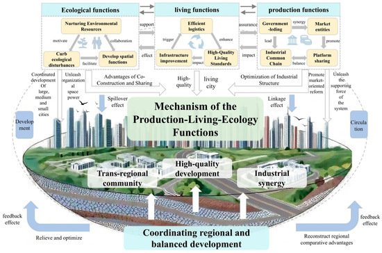
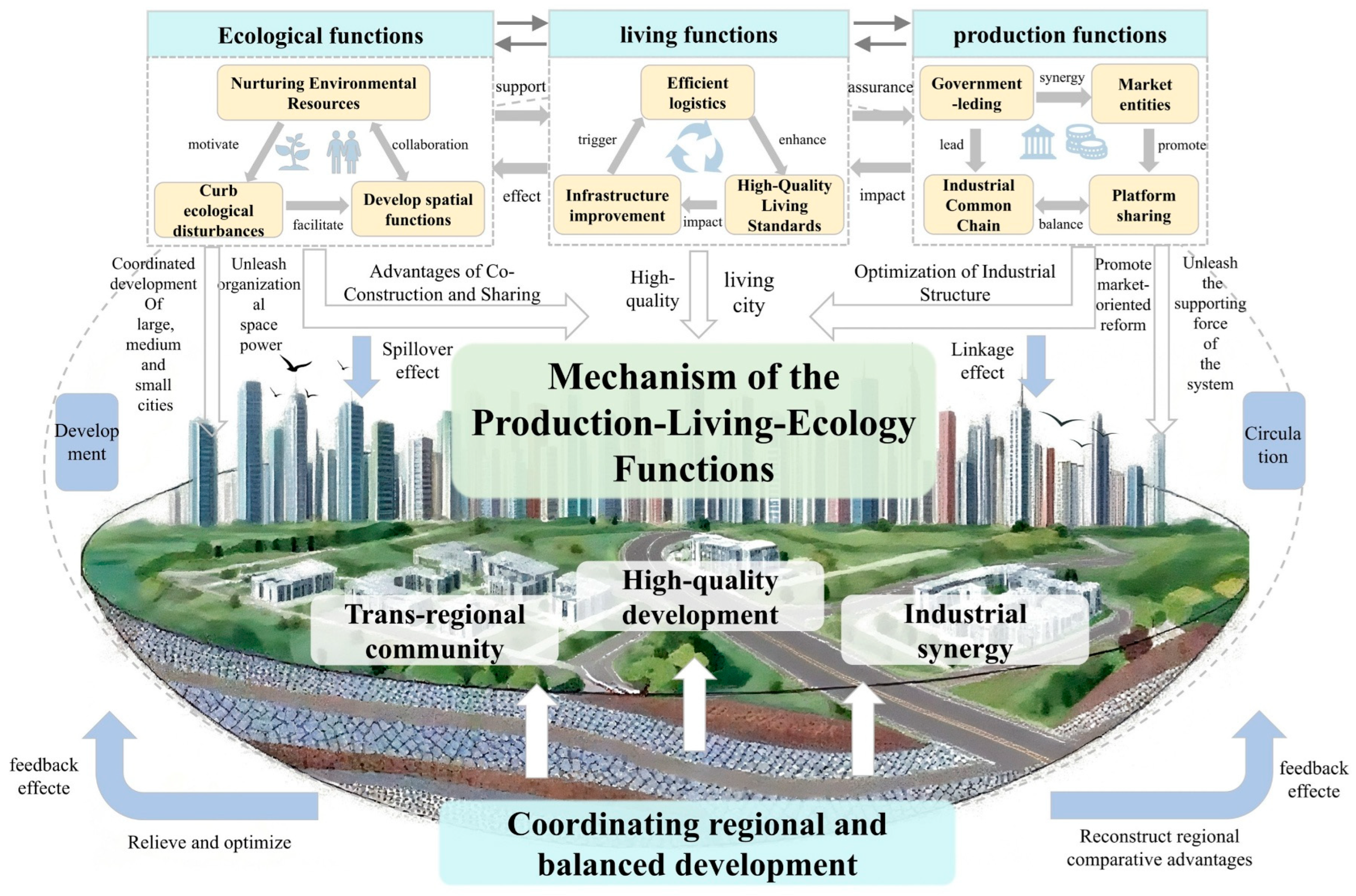
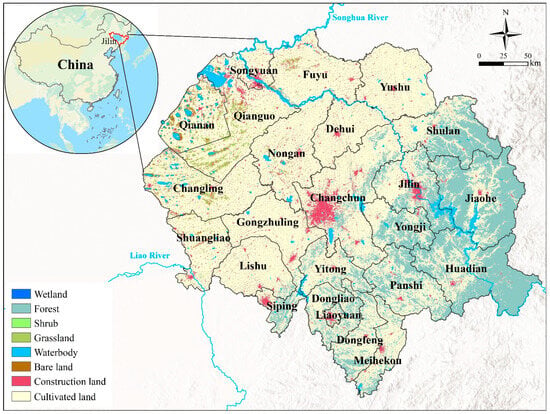
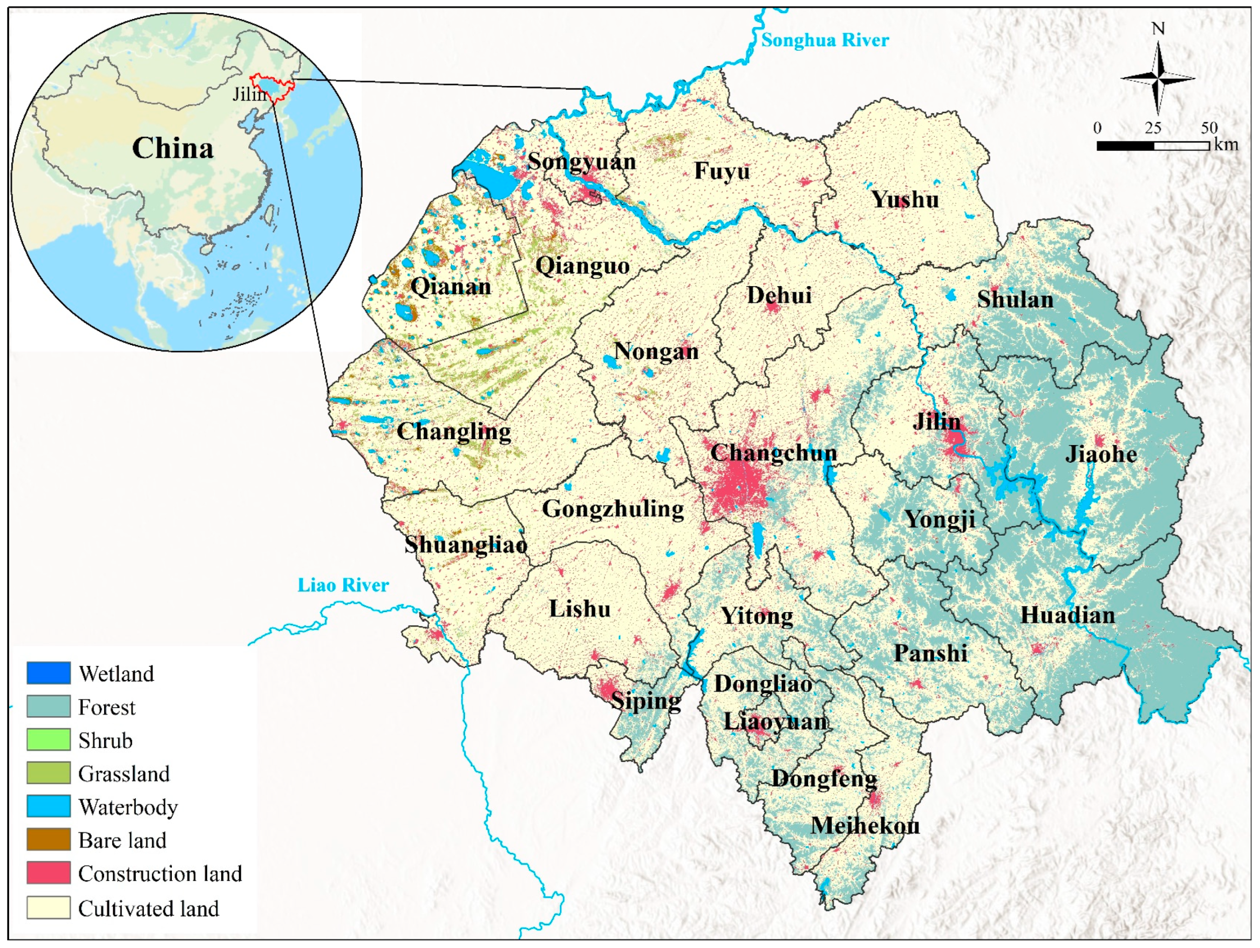
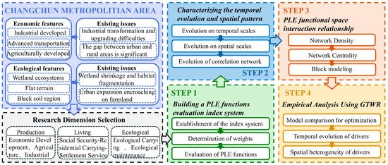
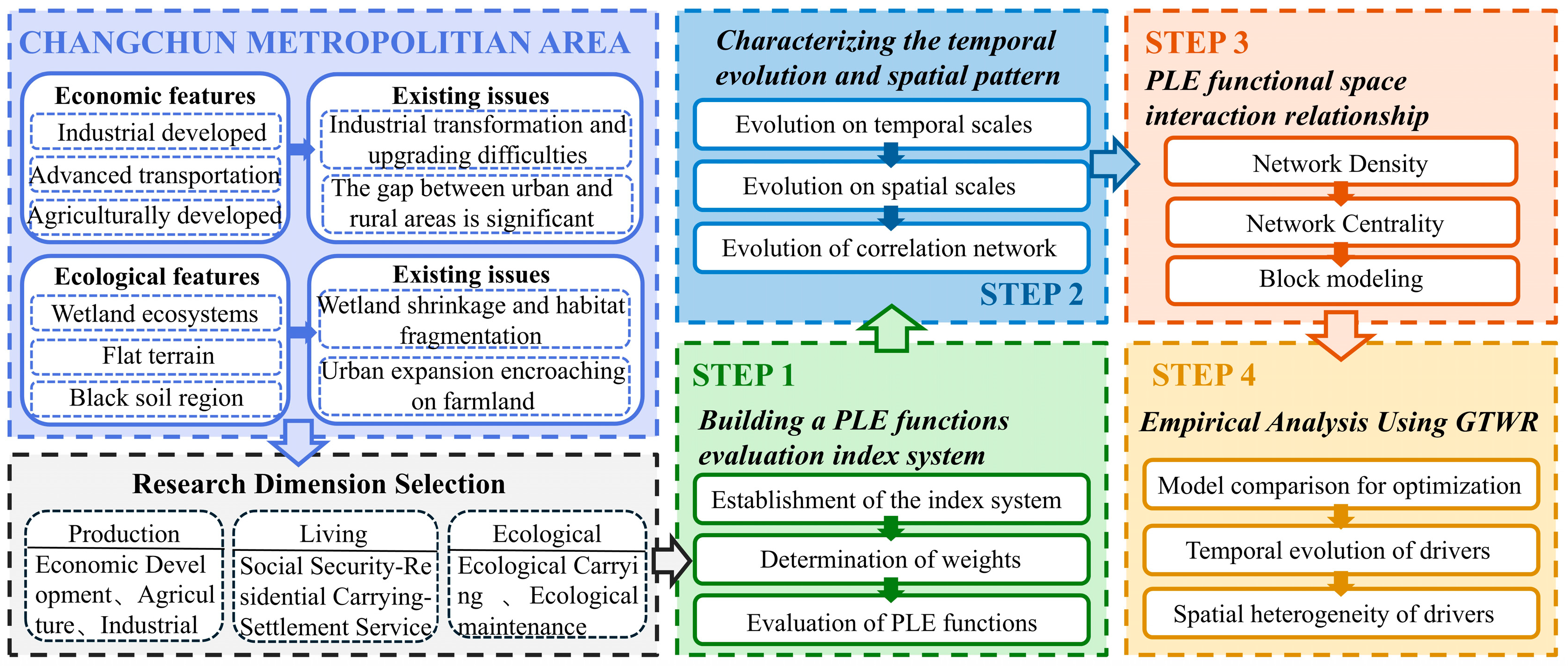
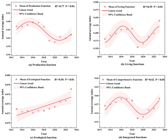
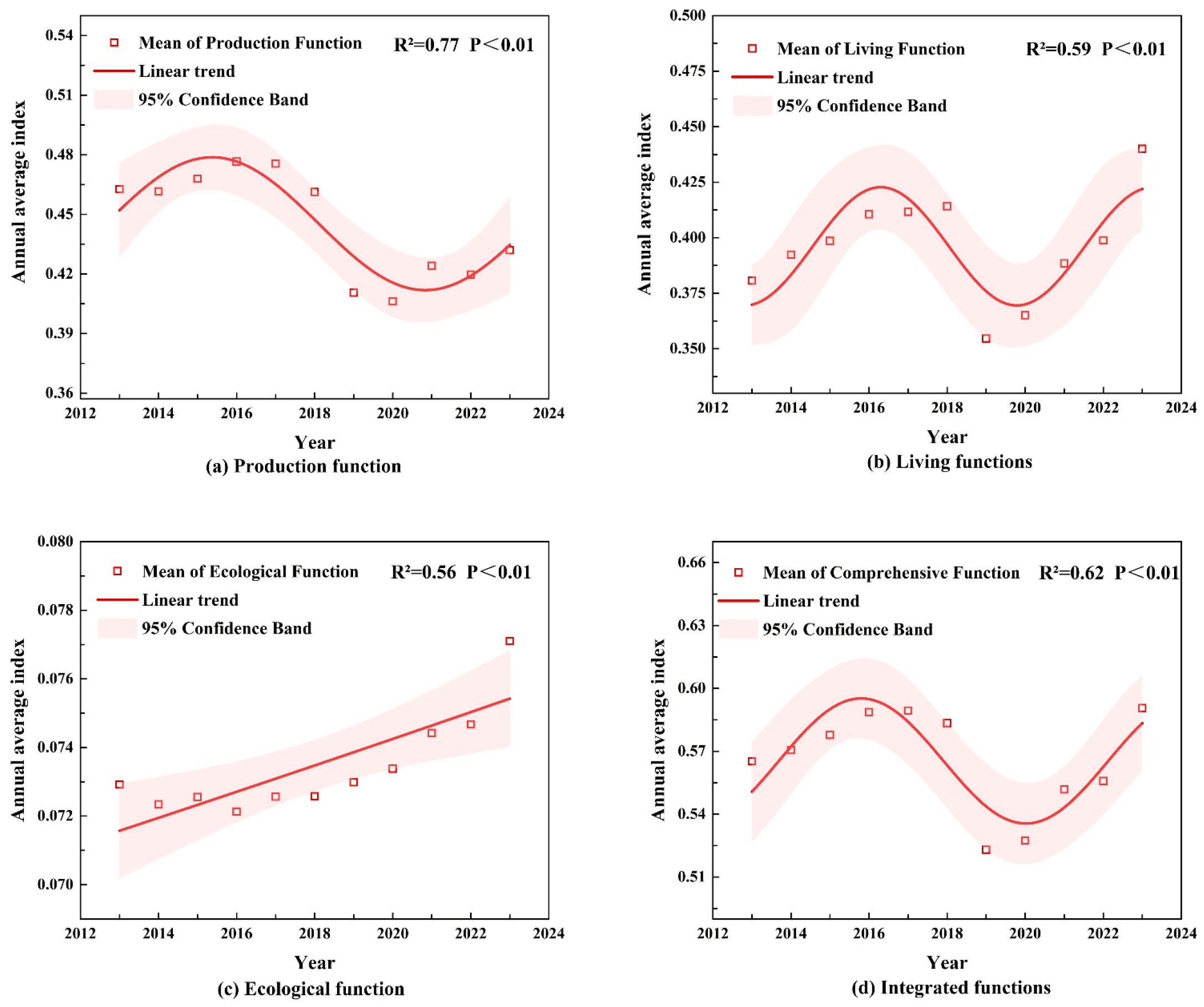
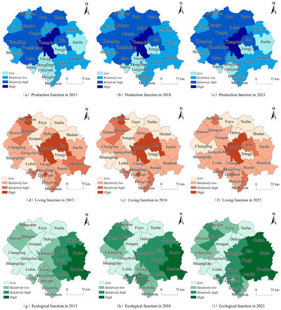
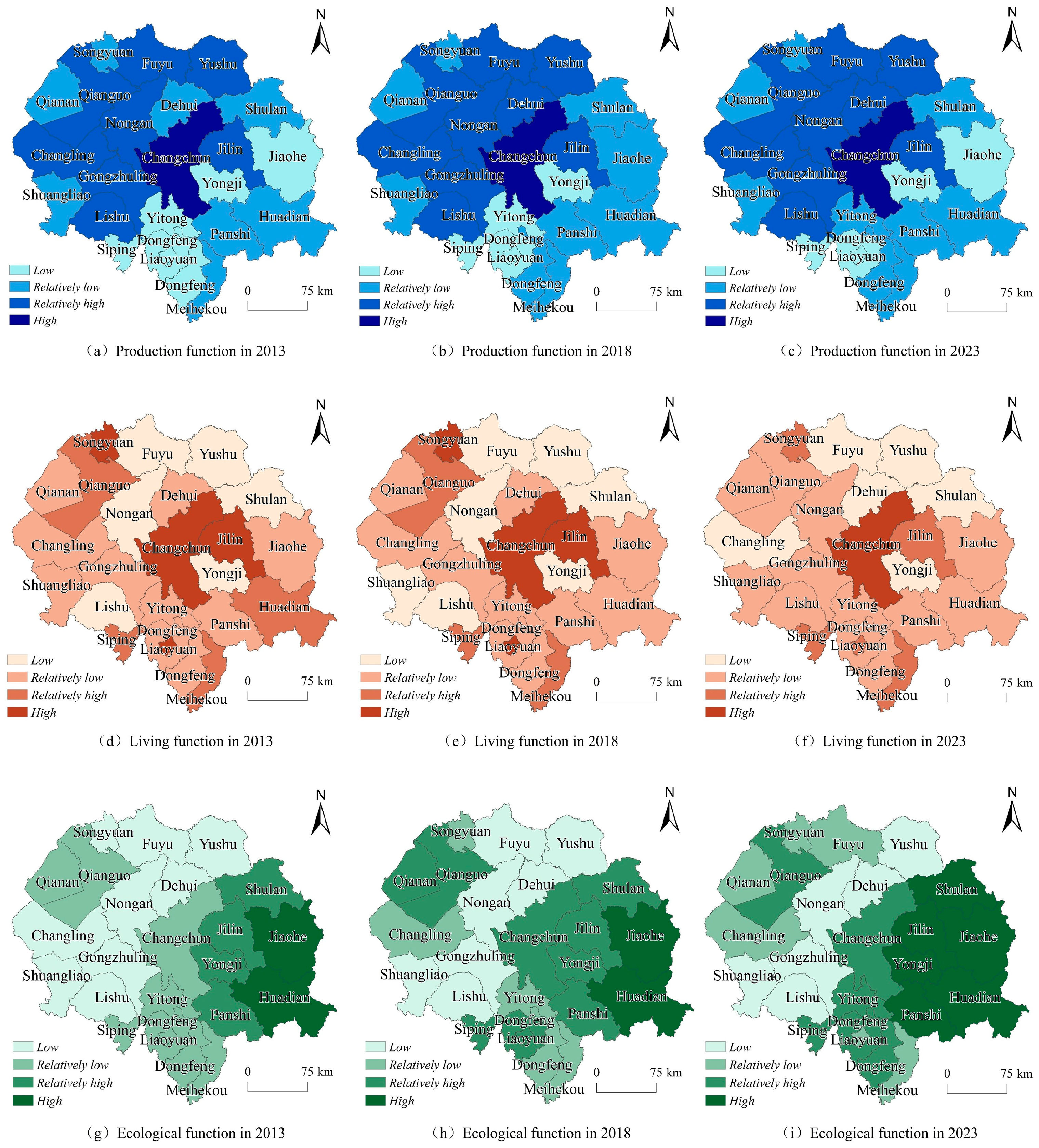
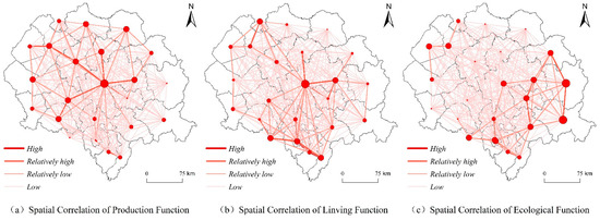
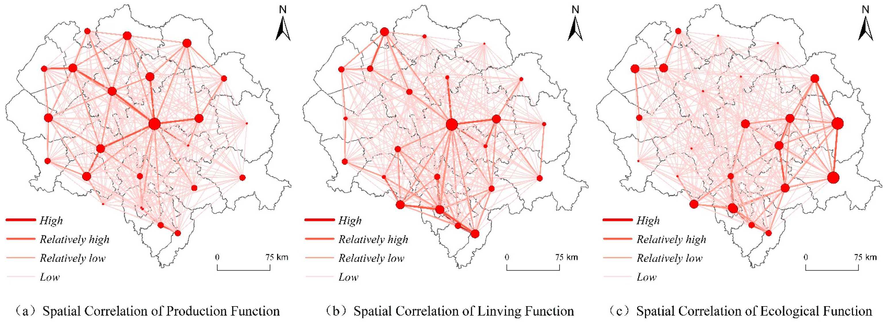
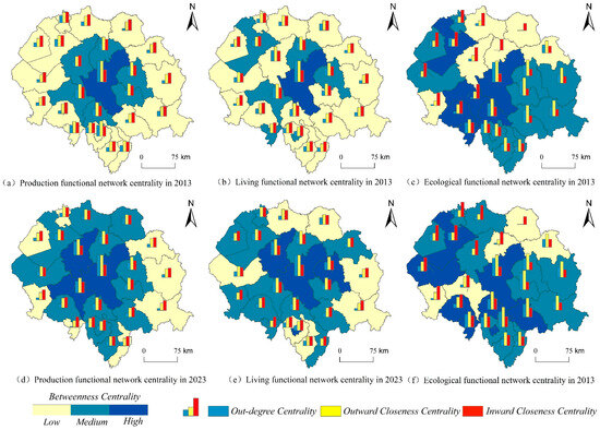
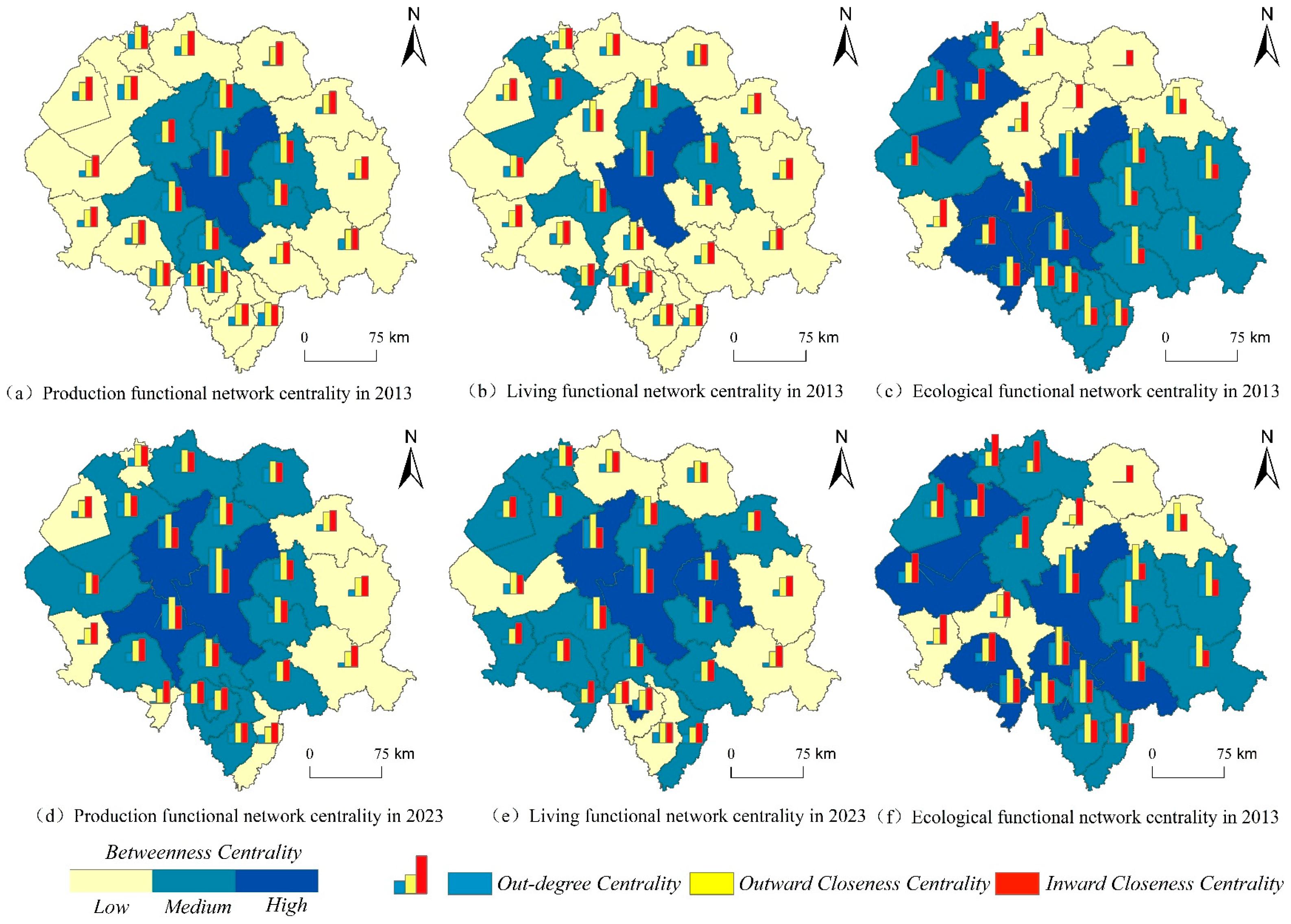
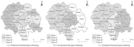
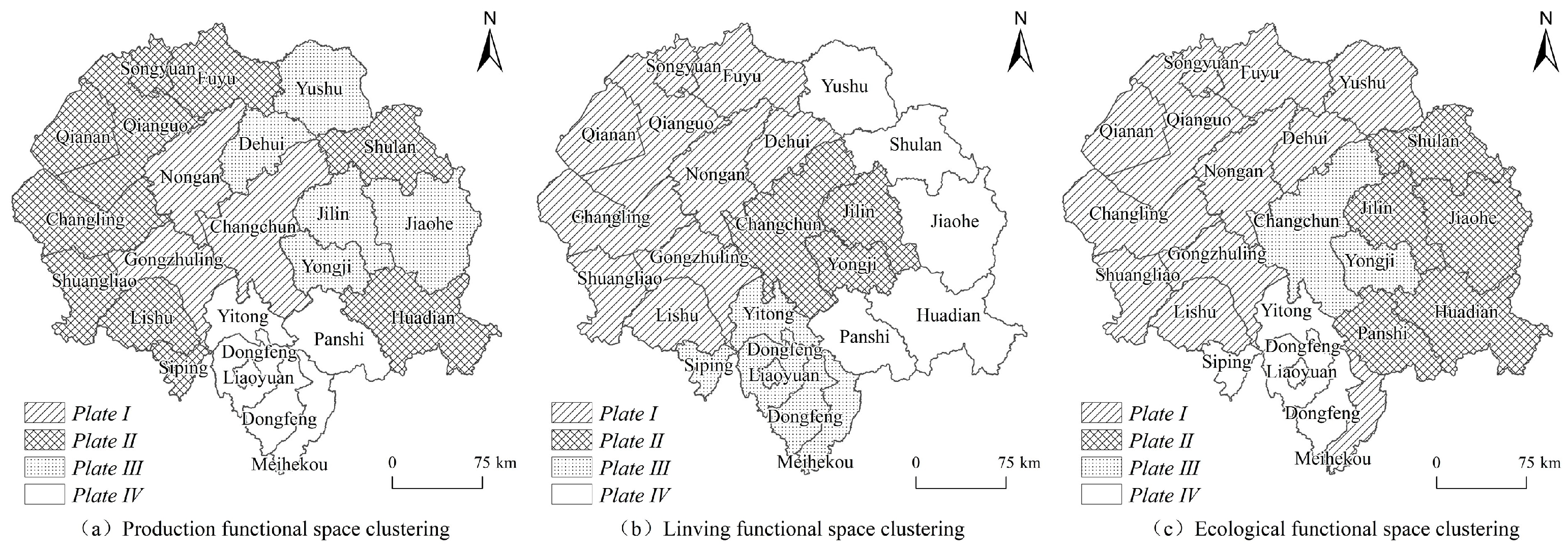
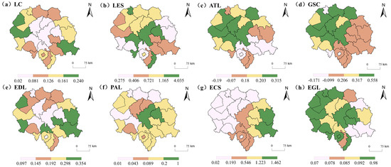
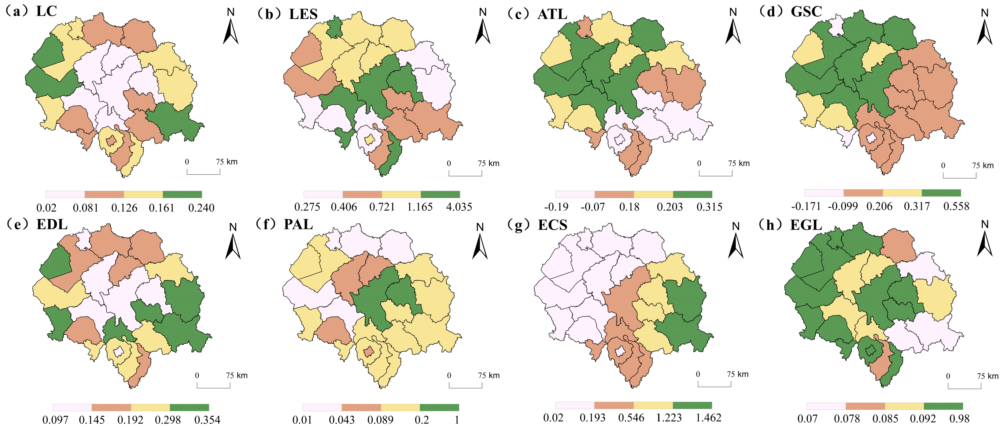

Disclaimer/Publisher’s Note: The statements, opinions and data contained in all publications are solely those of the individual author(s) and contributor(s) and not of MDPI and/or the editor(s). MDPI and/or the editor(s) disclaim responsibility for any injury to people or property resulting from any ideas, methods, instructions or products referred to in the content. |
© 2026 by the authors. Licensee MDPI, Basel, Switzerland. This article is an open access article distributed under the terms and conditions of the Creative Commons Attribution (CC BY) license.