


Abstract
This paper investigates the application of Transit-Oriented Development (TOD) principles to the retrofitting of historic Gulf urban cores through a comparative analysis of Souq Waqif (Doha) and Qasr Al Hokm (Riyadh). The research employs field observation, thematic mapping, and qualitative diagnosis using the Integrated Modification Methodology (IMM) to assess compactness, intricacy, and connectivity within walkable station catchments. The findings indicate that Souq Waqif has a highly compact and intricate historic core with robust pedestrian activity, yet exhibits discontinuities at its periphery, such as car-dominated streets, fragmented green spaces, and weak connections between the metro station, parks, and adjacent blocks. In Qasr Al Hokm, the analysis affirms the value of its fine-grained historic fabric and civic landmarks, but also identifies deficiencies in shading, last-mile connectivity, and land-use balance surrounding the new metro station. Drawing on lessons from Souq Waqif, the paper proposes a TOD-oriented urban design framework for Qasr Al Hokm, emphasizing shaded pedestrian corridors, active ground floors, intermodal hubs, and heritage-compatible mixed-use intensification. This comparative approach demonstrates how TOD can foster more livable, accessible, and climate-responsive historic cores in Gulf cities, while maintaining respect for local identity and governance structures.
1. Introduction
Since the emergence of mechanized modes of transport, urban landscapes have undergone radical shifts, introducing a host of new challenges. These range from infrastructural inefficiencies and increased levels of environmental pollution to the diminishing presence of human scale in urban design [1,2]. Such challenges extend beyond physical infrastructure, exerting substantial impacts on public health, community well-being, and ecological resilience [3]. Urbanization, identified by the United Nations as a defining trend of the 21st century, has already concentrated more than half of the global population in cities, with projections suggesting this proportion will approach 70% by 2050 [4]. In this context, the pursuit of sustainability has become a central priority in urban development, emphasizing the need for innovative planning frameworks that safeguard resilience and enhance long-term urban livability [5]. Transit-Oriented Development (TOD) represents one such framework. As an urban planning approach, TOD promotes compact, pedestrian-friendly neighborhoods structured around efficient, easily accessible public transport systems. By integrating land-use planning with mobility infrastructure, TOD seeks to reduce reliance on private vehicles, improve accessibility for diverse populations, and advance the creation of sustainable and socially vibrant urban environments foster the creation of sustainable, socially vibrant urban environments [2,6].
Scholars have extensively explored TOD as a progressive paradigm capable of fostering walkable, well-connected urban communities while mitigating the negative consequences of rapid metropolitan expansion [7,8]. Nonetheless, the literature cautions against adopting a universal or standardized TOD model. Su et al. [9] emphasize the need for context-sensitive frameworks tailored to distinct urban typologies. At the same time, Alam and Khalil [10] argue that successful TOD implementation must be shaped by a given place’s cultural, spatial, and socio-economic conditions. Empirical findings support the role of TOD in advancing sustainability objectives by promoting public transport use and curbing car dependency [11]. Yet a persistent gap remains in identifying the specific conditions that maximize TOD’s effectiveness across diverse contexts.
The selection of Souq Waqif in Doha and Qasr Al Hokm in Riyadh as comparative case studies is grounded in their shared role as historic, centrally located, mixed-use districts that are now being reshaped by the introduction of new metro systems. Souq Waqif represents Doha’s restored historic marketplace, an intensely used, low- to mid-rise heritage quarter that functions as a cultural, commercial, and touristic hub [9,12,13,14]. Qasr Al Hokm embodies the historic and civic core of Riyadh, an area that has evolved from the old city nucleus into a complex urban environment where heritage preservation [15,16,17], administrative functions, and new mobility infrastructures intersect [18].
Both districts sit on key metro corridors and are embedded in national regeneration agendas, making them well suited for examining how TOD principles can be adapted to heritage-based Gulf urban morphologies. Both analyses are conducted within a consistent 1000 m TOD catchment (≈3.14 km2) around the station access point, ensuring a like-for-like spatial frame for mapping and observation. In Doha, Souq Waqif is served by the Gold Line (≈14 km, 11 stations) within a metro system of roughly 76 km and 37 stations, operational since 2019. In Riyadh, Qasr Al Hokm is a major downtown interchange within the Riyadh Metro (176 km, 85 stations), connecting the Blue and Orange lines, with a reported station area of approximately 22,500 m2. At the district scale, the Qasr Al Hokm redevelopment program documents a phase area of 320,000 m2 (about 60% of the district), reinforcing the cases’ comparability as compact, metro-served heritage cores subject to public-realm retrofit constraints. Using the same 1000 m catchment also standardizes the comparative reading of mapped indicators (e.g., permeability and route continuity), allowing differences to be attributed to urban structure and station-edge conditions rather than study extent.
Souq Waqif was selected because it exemplifies a compact, heritage-based urban district where the introduction of metro infrastructure directly intersects with pedestrian life, tourism flows, and a regenerated historic fabric. Souq Waqif’s significance lies in its dual identity as a heritage marketplace and major mobility node within central Doha. Served by the Souq Waqif station on the Doha Metro, the area combines compact street patterns, arcaded commercial fronts, and a dense program of cafés, shops, hotels, and cultural venues within a highly walkable yet climatically demanding setting. The neighborhood has undergone intensive regeneration since the mid-2000s, with a comprehensive restoration program that reintroduced vernacular architectural language and reorganized its plazas and internal alleys to support pedestrian life. Nonetheless, despite its strong center–city location and human-scale fabric, the area continues to face challenges, including fragmented links to surrounding blocks, car-dominated edges, limited shaded connections to adjacent parks, and discontinuous cycling and pedestrian infrastructure.
Qasr Al Hokm, by contrast, represents Riyadh’s historic and administrative heart [15], anchored by Qasr Al Hokm Palace, Al Masmak Fort, the Imam Turki bin Abdullah Grand Mosque, and traditional souqs such as Al Zal. While its urban grain is inherently pedestrian-oriented, decades of piecemeal modernization have produced broad vehicular corridors, surface parking, and discontinuous public spaces that compromise walkability and microclimatic comfort. Qasr Al Hokm’s significance lies in its dual identity as a cultural and civic center and as a gateway for sustainable mobility integration within Riyadh’s downtown. The inauguration of the Qasr Al Hokm Metro Station on the Riyadh Metro Blue Line creates new possibilities for integrating TOD strategies within a heritage-sensitive context, but also exposes gaps in last-mile connectivity, shaded networks, and multimodal integration. The area combines traditional street patterns, compact blocks, and mixed-use activities, mosques, souqs, government buildings, and small-scale commerce, within a walkable yet climatically challenging setting [17]. The district has been the subject of successive regeneration initiatives since the 1980s, most notably the Qasr Al Hokm Development Project, which sought to revitalize the old city core through public space enhancement and architectural restoration. However, despite its pedestrian-oriented morphology, issues such as fragmented land ownership, limited shading, and inconsistent urban continuity persist, constraining the potential for true TOD integration. Examining Qasr Al Hokm thus enables the study to explore how TOD strategies can operate within heritage-sensitive, climatically extreme environments, where modernization must coexist with cultural authenticity [19,20].
The comparative approach, therefore, enables a cross-scalar understanding of TOD application in Gulf cities at different stages of modernization. Specifically, it examines how regulatory adaptation, design integration, and governance coordination can facilitate walkability, multimodal access, and mixed-use intensification in contexts with contrasting spatial legacies. Both case studies share the following baseline characteristics:
Central heritage districts with strong symbolic value;
Served by new metro stations;
Characterized by compact, intricate fabrics interlaced with car-oriented retrofits;
Targeted by national visions [21,22] that emphasize sustainable mobility and cultural preservation.
Within this scholarly discourse, the present research is positioned. The study seeks to address the central questions:
How do Souq Waqif and Qasr Al Hokm differ in their spatial morphology, land-use structure, and connectivity profiles relevant to TOD?
What cultural, regulatory, and design barriers constrain TOD implementation in heritage-based districts in Doha and Riyadh?
How can TOD principles be contextually operationalized to enhance livability and accessibility while preserving cultural identity and climatic resilience in both sites?
What comparative lessons from Souq Waqif and Qasr Al Hokm can inform adaptable TOD strategies for historic cores in Gulf cities more broadly?
Through these questions, the research aims to develop a context-responsive TOD framework that addresses both heritage preservation and sustainable growth, reinforcing urban resilience and accessibility across diverse Gulf environments.
To answer these questions, the study applies five TOD-informed design principles as evaluative lenses:
- (1)
- Pedestrian walkability;
- (2)
- Balanced land use at the ground level;
- (3)
- Integration of mixed-use development with public spaces;
- (4)
- Intermodality and transport hub efficiency;
- (5)
- A resilient public transportation network.
The research first contextualizes Souq Waqif within the broader policy and planning framework of TOD in Doha. It then grounds the analysis in TOD theory, with particular attention to the ways compactness, connectivity, and urban intricacy shape urban livability and resilience.
The methodological approach employs the Integrated Modification Methodology (IMM) and TOD-informed indicators, combining field observation, thematic/visual mapping, and qualitative diagnosis of station-area performance across the three IMM pillars (compactness, intricacy, and connectivity).
Findings reveal significant deficiencies in the connectivity and multimodal integration surrounding the Souq Waqif and Qasr Al Hokm metro stations. At the same time, the analysis demonstrates the potential of metro stations in heritage-rich areas to operate not only as transport infrastructures but also as catalysts for sustaining cultural identity and social interaction in rapidly modernizing urban settings.
The paper concludes by proposing design interventions that are both sensitive to the unique urban fabric of Souq Waqif and Qasr Al Hokm, particularly aligned with the broader goals of sustainable urban development. These recommendations reinforce the necessity of locally responsive planning approaches in rapidly urbanizing regions. By analyzing the interplay between porosity, proximity, and accessibility, the research contributes to a more integrated understanding of how TOD principles can be adapted to specific contexts. Ultimately, the study provides a comprehensive framework for reimagining transit-oriented development through strategies that are at once theoretically grounded and contextually tailored.
This study adopts a comparative logic because Souq Waqif and Qasr Al Hokm represent two emblematic Gulf historic cores that are simultaneously cultural destinations and emerging metro-access nodes. Comparing them enables the identification of transferable TOD retrofitting strategies, while also acknowledging context-specific constraints related to heritage protection, governance, and public-realm use. The comparison is therefore used to produce design-oriented guidelines aligned with compactness, intricacy, and connectivity. This study addresses a documented gap in Gulf TOD research by providing a cross-country, station-specific qualitative spatial diagnosis of newly realized metro precincts anchored in heritage cores, using IMM-based mapping to translate observed conditions into transferable retrofit guidance.
Accordingly, the study proceeds through Phase I context analysis and Phase II qualitative diagnosis using IMM-informed mapping and structured field observations, and then translates the diagnosed weaknesses into Phase III station-area retrofit guidance.
2. Background
2.1. Souq Waqif in Doha
The rapid urban expansion of Doha has generated a series of critical challenges, particularly in mobility. Among the most pressing issues are traffic congestion, unchecked urban sprawl, and the inefficiency of public transport systems [23,24]. These conditions not only undermine residents’ quality of life but also exacerbate environmental degradation and the overuse of finite natural resources [1,25]. The city’s urbanization strategies have historically prioritized large-scale infrastructure and private vehicular mobility, often at the expense of human-centered planning [13,26,27]. Consequently, Doha’s urban form frequently discourages pedestrian activity and weakens both place identity and community cohesion. The marginalization of walking as a viable mode of transport has particularly reduced the livability of central districts while reinforcing reliance on private automobiles [23].
In an effort to address these challenges, the State of Qatar introduced the Qatar National Vision 2030 [21], a comprehensive framework designed to balance rapid urban growth with long-term sustainability objectives. Central to this vision is the establishment of integrated, efficient transportation networks encompassing both roadway systems and public transit infrastructure. Against this backdrop, the present study evaluates the potential of Transit-Oriented Development (TOD) around the Souq Waqif metro station. The objective is to propose urban design and planning strategies that can strengthen livability, sustainability, social cohesion, and economic vitality within the surrounding neighborhood. Furthermore, the study situates Doha within the framework of a complex adaptive system (CAS). It examines how compactness, connectivity, and intricacy can be leveraged to retrofit, renovate, and revitalize the Souq Waqif area.
Souq Waqif, a historic marketplace with roots extending back at least a century, underwent major revitalization in 2006 to preserve its vernacular architecture while positioning it as a leading cultural and touristic attraction. Situated at the heart of Doha, it has since become both a commercial and cultural landmark [12,13,28]. Of particular relevance is the Souq Waqif metro station, strategically located along the metro network and providing direct access to key destinations, including Msheireb Downtown Doha, the Corniche, the Museum of Islamic Art, and the adjacent Asiri, Al Jabr, and Gold Souqs (Figure 1).
Figure 1.
Location map of the study area, red dotted line represents Souq Waqif neighborhood, red line represents Souq Waqif Metro Station area.
The study focuses on the Souq Waqif metro station, a key transit hub along the metro line that provides access to significant landmarks such as Msheireb Downtown Doha, the Corniche, the Museum of Islamic Art, and the traditional Asiri, Al Jabr, and gold Souqs (Figure 2).
Figure 2.
Significant landmarks near Souq Waqif.
This context offers a valuable case for exploring how intricacy, compactness, and connectivity, principles highlighted in the literature on sustainable urbanism, can inform regeneration practices. By applying TOD-driven design strategies, this research aims to support the transformation of Souq Waqif into a more sustainable, efficient, and pedestrian-oriented urban environment.
2.2. Qasr Al Hokm in Riyadh
While much of Riyadh’s TOD discourse has centered on emerging business corridors and planned megaprojects such as the King Abdullah Financial District, far less emphasis has been placed on the historic and civic heart of the city surrounding Qasr Al Hokm. This area, anchored by the eponymous palace and the nearby Imam Turki bin Abdullah Grand Mosque, represents the symbolic and administrative core of Riyadh, an urban fabric characterized by compact street networks, traditional souqs, and heritage structures interwoven with recent public realm improvements. The introduction of the Qasr Al Hokm Metro Station along Riyadh’s Blue Line provides a transformative opportunity to integrate sustainable mobility within this dense, walkable, and culturally significant environment.
Unlike post-oil-era corridors such as Olaya, Qasr Al Hokm was not shaped by automobile urbanism but rather by pedestrian-oriented morphology rooted in Najdi architectural traditions. Nevertheless, decades of ad hoc modernization, surface parking expansion, and fragmented redevelopment have weakened the area’s continuity and accessibility. TOD-oriented revitalization thus holds the potential to reconcile heritage preservation with contemporary mobility and livability goals.
The area’s fine-grained block structure, high population density, and proximity to major civic and commercial nodes create ideal preconditions for transit integration, mixed-use intensification, and climate-responsive public space retrofits [19,20,29]. Recent studies on Riyadh’s downtown regeneration highlight the challenge of balancing conservation mandates with vertical densification [30].
In this respect, Qasr Al Hokm offers a laboratory for low-rise, high-density TOD models compatible with heritage contexts, emphasizing shaded arcades, adaptive reuse of historic buildings, and micro-mobility linkages to adjacent neighborhoods such as Al Batha and Al Dirah. Comparative TOD research [31,32] underscores the role of form-based codes, pedestrian prioritization, and multimodal integration in achieving urban livability in climatically demanding cities [33,34]. Moreover, the integration of the station with Riyadh’s broader pedestrian network and public transport grid requires coordinated governance among the Royal Commission for Riyadh City (RCRC), the Saudi Public Transport Company (SAPTCO), and heritage preservation bodies [20].
In synthesis, Qasr Al Hokm stands as a pivotal site for applying TOD principles in a heritage-sensitive context, where urban mobility, cultural identity, and sustainable design intersect [35] (Figure 3). By aligning land-use policy, regulatory incentives, and public realm investment, the district can evolve into a model of contextual TOD that redefines central Riyadh as a walkable, connected, and inclusive urban core [31,32].
Figure 3.
Significant landmarks near Al Hokm. Orange and blue lines represent respectively Orange and Blue Metro lines in Riyadh.
3. Literature Review
Most urban studies addressing neighborhood analysis and activation tend to concentrate on isolated components of the built environment. By contrast, this research adopts a more systematic and integrative framework by applying the Integrated Modification Methodology (IMM). Unlike conventional approaches, IMM dissects the Design Ordering Principles (DOPs) of the built environment into their fundamental subsystems and provides a synthesis mechanism that highlights how these subsystems interact and reinforce one another (Figure 4).
Figure 4.
The list of the DOP (Ordering Design Principles) in IMM and their relationship with key categories (KC). Source: adopted from IMMdesignlab and re-elaborated by the authors.
The DOPs represent core principles for shaping sustainable and optimized urban environments. Grounded in systems thinking, they enable urban designers and planners to bridge multiple engineering domains while balancing competing trade-offs to arrive at holistic solutions. These principles emphasize dimensions such as building and population density (compactness), socio-spatial transactions and interactions (intricacy), and accessibility to key destinations (connectivity). The subsequent review will unpack these concepts to frame the research questions and situate the findings within the Souq Waqif and Qasr Al Hokm case studies (Figure 5).
Figure 5.
IMM overview adopted from IMMdesignlab and re-elaborated by the authors.
The spatial organization of a city plays a decisive role in shaping its environmental efficiency, energy consumption, transport performance, distribution of green and public spaces, and, ultimately, the well-being of its inhabitants. IMM conceptualizes the city as a Complex Adaptive System (CAS), in which a network of interdependent elements collectively shapes the behavior of the whole. Accordingly, the analysis considers both the tangible and intangible aspects of the built environment, encompassing urban volumes (built-up areas), urban voids (open spaces), land-use functions, and mobility infrastructures (Figure 5).
Central to IMM is the identification of Key Categories (KCs), which serve as diagnostic tools for detecting systemic weaknesses and dysfunctions within the urban fabric. These structural attributes provide insights into the city’s spatial complexity and performance. The methodology organizes eight KCs into three overarching themes: compactness, connectivity, and intricacy. The KCs include porosity, permeability, proximity, accessibility, effectiveness, interface, diversity, and continuity.
A substantial strand of Transit-Oriented Development (TOD) research operationalizes station-area performance through quantitative indicators and benchmarks [36,37], commonly focusing on density and mix measures, walk-shed/catchment analytics, and travel outcomes such as transit use and mode share. Empirical syntheses in the built-environment literature have demonstrated consistent relationships between travel behavior and measurable urban form variables, including proximity to transit, land-use diversity, and street-network characteristics, and these are frequently tested through statistical models and standardized indicator sets [2]. Complementing this evidence base, widely used assessment frameworks such as the ITDP TOD [38,39]. Standard translate TOD principles into measurable criteria that support benchmarking across station areas. Quantitative station typologies derived from the node–place family of models similarly classify TOD conditions by scoring transit “node” strength and urban “place” intensity/diversity, enabling comparative evaluation across contexts [36,40].
While these quantitative approaches are essential for network-wide performance auditing, they do not always capture the micro-scale, context-dependent conditions that often determine whether station areas function effectively as walkable TOD environments, particularly in heritage cores and hot–arid settings where last-mile comfort, interface quality, and barrier crossings can dominate user experience. For this reason, the present study positions IMM as a scientific, diagnostic, and comparative framework that complements quantitative TOD metrics by translating observed station-to-core conditions within the TOD radius into a structured identification of systemic weaknesses and retrofit priorities. This positioning aligns with contemporary measurement research that recognizes the value of combining mapped indicators with fine-grained diagnostic assessment of station-area environments when ridership or pre/post datasets are unavailable or not accessible at the required spatial resolution for heritage-core catchments.
The following sections examine these KCs under their respective thematic categories, demonstrating how each contributes to a comprehensive urban diagnosis. By applying IMM to the Souq Waqif and neighborhood, this study seeks to evaluate its structural organization and propose design interventions that enhance sustainability, mobility, and livability.
Recent scholarship has increasingly examined the intersection of Transit-Oriented Development (TOD) and historic districts, highlighting both synergies and tensions when new station-area intensification meets conservation imperatives [41]. A key thread argues that TOD implementation in heritage contexts must prioritize public-realm performance and access quality over conventional densification logics, because historic cores often already contain compact block structures and mixed uses, while their main constraints are typically last-mile friction, edge/interface conflicts, and pedestrian comfort rather than land-use scarcity. In this regard, Renne emphasizes that TOD and historic preservation can be mutually reinforcing when station planning is aligned with district character and when retrofit actions protect heritage value while improving walkability and multimodal access, but also notes that TOD delivery can generate conflicts if redevelopment pressures or infrastructure requirements undermine historic fabric or displacement-sensitive uses [41,42]. A second body of work focuses on station proximity to historic assets and the implications for planning controls, finding that a substantial share of station areas intersect with designated historic districts and therefore requires governance tools that go beyond standard TOD playbooks. Guidance-oriented studies show that the “heritage–TOD” interface benefits from a clearer distinction between interventions that are primarily physical-design and public-realm retrofits (often more transferable) and those relying on regulatory and operational mechanisms (often context-dependent), including curb allocation, parking management, enforcement, and incentive structures that mediate land-use change and visitor mobility. This distinction supports an evidence-led approach to TOD in historic settings, where the goal is to convert station proximity into low-friction, legible, and climate-comfortable station-to-anchor movement without compromising authenticity [42]. Within Gulf city scholarship, emerging work has begun to connect heritage regeneration and metro-era accessibility through station-area planning and retrofit strategies. Research on Souq Waqif, for example, frames station integration as an urban-regeneration problem in which heritage protection, land infill, and public-realm upgrading must be coordinated to improve walkability and the station interface, reinforcing the relevance of heritage-sensitive TOD toolkits for traditional market districts [12]. These studies collectively indicate a research gap that remains central to this paper: while TOD principles are widely discussed for Gulf metropolitan transformation, fewer studies operationalize how heritage-core morphology and microclimate constraints interact with station-edge operations and governance capacity to shape TOD performance. Addressing this gap requires methods that translate heritage-sensitive TOD concepts into mappable evidence and implementable retrofit priorities, which motivates the study’s IMM-based comparative diagnosis.
Ultimately, IMM provides an advanced analytical framework that captures the interdependencies within urban systems, generating actionable insights to guide urban regeneration and transformation.
3.1. Urban Morphology and Compactness: Pathways to Sustainability
Compact cities are typically defined by high-density development and a diverse mix of land uses. The literature underscores numerous benefits associated with compact urban forms, including reduced reliance on private vehicles, lower fuel consumption and emissions, and greater uptake of sustainable modes of mobility such as public transit, walking, and cycling [43]. Compactness also facilitates efficient access to services, improves the provision of infrastructure and utilities, and generates opportunities for urban regeneration.
A pedestrian-oriented focus in compact cities resonates with public demand for walkable and vibrant environments. By integrating different land uses within concentrated spaces, compact urban forms help to mitigate urban sprawl and prevent land fragmentation [44]. High-density, mixed-use environments are widely acknowledged as critical indicators of sustainable urbanism, addressing the challenges of rapid urbanization while maximizing economic, social, and ecological outcomes [25,45].
Extensive research links compact urban development to lower transportation-related emissions, reduced energy consumption, and improved accessibility to amenities. Furthermore, compactness fosters labor productivity through agglomeration economies and results in a smaller ecological footprint due to efficient energy and land use [39,46]. The Organization for Economic Co-operation and Development has also reported that compact city policies reduce carbon emissions and transport energy demand, while simultaneously lowering infrastructure costs and enhancing productivity.
Urban morphology plays a crucial role in reinforcing compactness. A well-designed physical layout, encompassing street patterns, block structures, and open spaces, can minimize land consumption, optimize infrastructure use, and enhance connectivity. Compact urban forms tend to support sustainable transport modes by encouraging walking, cycling, and public transit, thereby reducing congestion, greenhouse gas emissions, and air pollution [1]. They also improve social cohesion by ensuring proximity to essential services and fostering inclusive urban systems.
Compact cities further contribute to resilience by promoting efficient land use, enhancing connectivity, and reducing vulnerability to environmental risks. Their smaller per capita ecological footprint, particularly in terms of energy use and carbon emissions, supports environmental sustainability [47]. Social equity is also advanced, as compact urban environments provide more equitable access to education, employment, healthcare, and recreational opportunities.
The Integrated Modification Methodology (IMM) supports compactness as a key diagnostic tool for assessing a city’s resilience. Within IMM, compactness captures both the density and the spatial distribution of functions, focusing on proximity and interrelations among different components of the built environment [48]. IMM evaluates compactness through Key Categories (KCs), which highlight systemic strengths and weaknesses across dimensions such as porosity, permeability, proximity, accessibility, effectiveness, interface, diversity, and continuity. For instance, porosity, reflecting the degree of interconnection between built and open spaces, plays a pivotal role in understanding both the physical and functional aspects of compactness [49].
In sum, compactness emerges as a critical dimension of sustainable urbanism, influencing efficiency, livability, resilience, and inclusivity. This research extends the discussion by examining compactness as a multidimensional attribute of urban systems. Using the Souq Waqif metro station in Doha as a case study, this study investigates how compactness manifests in practice and how targeted interventions can enhance its role in promoting sustainable urban development.
3.2. Enhancing Urban Connectivity: Socio-Economic and Ecological Dimensions in Transit-Oriented Contexts
Urban connectivity can be broadly understood in two dimensions: socio-economic connectivity and ecological connectivity [50]. Socio-economic connectivity refers to the infrastructure and systems that enable the movement of people, goods, and services, such as transportation networks. Ecological connectivity, in contrast, emphasizes the integration of natural and semi-natural environments, including urban green parks and open spaces. Together, these dimensions contribute to urban sustainability, livability, and accessibility.
In recent decades, the focus of connectivity has shifted from prioritizing private vehicle movement to advancing sustainable forms of mobility. Increasingly, cities prioritize pedestrian connectivity and intermodal transportation systems, which enhance accessibility while reducing environmental impacts. This shift is reflected in Transit-Oriented Development (TOD) models, which promote integration of multiple transport modes, metros, buses, cycling, and walking, to strengthen urban connectivity [51].
Within the framework of the Integrated Modification Methodology (IMM), urban connectivity is analyzed through the relationship between:
- Mobility and built-up areas;
- Mobility and function, particularly through the dimensions of effectiveness and accessibility.
Accessibility refers to the ease of reaching key destinations through public transportation within reasonable travel times [49]. Effectiveness, on the other hand, evaluates the efficiency of public transport systems in relation to the volume of building blocks and their spatial layout [48].
From an IMM perspective, urban connectivity shapes a city’s overall performance in several ways:
- Efficient Mobility: Well-structured transport networks, including public transit and pedestrian pathways, facilitate access to services, jobs, and amenities, directly improving quality of life.
- Resource Optimization: By diagnosing systemic inefficiencies, IMM identifies opportunities to reduce energy use, ease traffic congestion, and allocate resources more effectively.
- Resilience and Adaptability: Robust connectivity enhances a city’s capacity to withstand and recover from disruptions such as natural disasters or socio-economic shocks.
- Data and Information Flow: In the digital era, connectivity supports governance, decision-making, and citizen participation by ensuring the efficient flow of information.
- Environmental Impact: IMM evaluates the ecological implications of connectivity, particularly regarding air quality, greenhouse gas emissions, and land-use patterns, to reduce negative externalities [26,52,53].
Closely related to connectivity is the concept of permeability, which refers to the ease of pedestrian movement and the degree to which urban layouts encourage access to public spaces. While permeability primarily concerns pedestrian flows, connectivity encompasses the broader movement of people, goods, and services across multiple urban systems [54]. In urban planning, the two are treated as interdependent: permeability fosters vibrant and walkable neighborhoods, while connectivity ensures integration across larger urban and regional scales [26,52,53].
This study applies IMM to assess the connectivity of the Souq Waqif metro station area in Doha, Qatar, where challenges include limited public transportation options and weak continuity between urban blocks. By diagnosing existing connectivity gaps, the research identifies design interventions that could strengthen accessibility and enhance overall mobility for residents and visitors alike.
3.3. Spatial Complexity and Functional Dynamics: Insights from the Integrated Modification Methodology
Modern cities are inherently complex, characterized by social diversity, uncertainty, and interwoven systems arising from the dense presence of people, activities, and infrastructures. Understanding the city as a complex system is essential for effective urban analysis and informed policymaking. Complex urban environments exhibit nonlinear, often unpredictable dynamics, in which minor interventions can lead to substantial, unforeseen consequences [55]. This unpredictability complicates the evaluation of policy impacts and underscores the necessity of careful, evidence-informed planning. Consequently, cities are frequently conceptualized as complex adaptive systems (CAS), in which components evolve and adapt in response to both internal dynamics and external influences [56,57].
To advance sustainable urban strategies, it is crucial to: (1) comprehend the behavior of cities and the built environment, and (2) identify the core characteristics of contemporary urban contexts. Within the Integrated Modification Methodology (IMM), the concept of urban intricacy is central. Urban intricacy is defined as the degree of efficiency in the distribution of functions across an urban area. Its analysis involves integrating functional diversity (the synthesis of activity types and spaces) and mobility interfaces (the movement and circulation of people and goods), thereby revealing imbalances or inefficiencies in urban functional arrangements. In essence, urban intricacy measures the organization, connectivity, and operational coherence of urban systems, providing a quantitative framework for assessing spatial complexity.
Urban intricacy is not static; it fluctuates over time and varies across different spatial scales. IMM accounts for these temporal and spatial dynamics to evaluate how urban systems adapt and evolve. A thorough understanding of intricacy enables urban designers and planners to optimize spatial layouts, enhance energy and resource efficiency, improve environmental performance, and elevate the overall quality of urban life [58].
Within IMM, urban intricacy serves as a key tool for identifying strategies that promote sustainable resource use, reduce environmental impacts, and increase urban livability. Two primary dimensions inform the analysis of urban intricacy:
Functional Diversity: This dimension examines the variety and spatial distribution of uses within urban blocks and across the city. Functional diversity provides insight into employment density, urban barriers (physical or psychological obstacles that impede movement), and catchment areas, the zones effectively served by specific land uses or facilities. For instance, around a metro station, the catchment area defines the region readily accessible to commuters. Land-use types, grouping functions often classify functional diversity according to their primary roles within the urban fabric [48].
Interface: This dimension evaluates urban circulation and transportation quality within the street network. Interface analysis illuminates the permeability and connectivity of urban voids, highlighting how efficiently people, vehicles, and goods traverse the city and how well distinct urban zones are interconnected.
By capturing both the distribution of functions and the dynamics of mobility, urban intricacy provides a comprehensive lens for evaluating and optimizing urban performance, sustainability, and quality of life. IMM leverages this concept to identify areas requiring intervention, ensuring cities are more accessible, resilient, and livable.
Applied to the Souq Waqif and Qasr Al Hokm neighborhood and metro stations, the study of urban intricacy underscores the importance of understanding functional distribution and movement patterns. By diagnosing gaps in connectivity, mobility, and accessibility, planners can propose interventions that enhance the efficiency of the urban system, improve livability, and support sustainable urban development.
3.4. Comparative TOD Framework for Historic Gulf Cores
Building on the comparative rationale established in the Introduction, this section defines the shared evaluation lens and the IMM/TOD criteria used to read both heritage cores consistently [52,59]. Both districts constitute historic cores retrofitted with modern metro infrastructure, yet they differ in their national planning frameworks, governance structures, and patterns of urban transformation (Table 1). Souq Waqif exemplifies a state-led, design-driven heritage regeneration project tightly coupled with new transit infrastructure. At the same time, Qasr Al Hokm illustrates a longer, more incremental trajectory of renewal, in which heritage, administrative, and mobility interventions have unfolded through multiple phases.
Table 1.
Key spatial, functional, and governance-related similitudes and differences between Souq Waqif and Qasr Al Hokm regarding TOD prospects.
Souq Waqif emerged as a traditional market at least a century ago and underwent major revitalization beginning in 2006, with the explicit goal of preserving vernacular architecture while promoting it as a cultural and touristic destination [60,61]. The Souq Waqif metro station, strategically located along the Doha Metro, provides direct access to key destinations such as Msheireb Downtown, the Corniche, and the Museum of Islamic Art, reinforcing its role as a transit-accessible cultural node. Despite its compactness and intense pedestrian activity, the surrounding blocks exhibit fragmented land use, car-dominated edges, limited greenery, and weak intermodal connections to the broader bus network.
Qasr Al Hokm, one of the oldest parts of Riyadh, developed organically around Al Masmak Fort and the palace complex, with an intricate street network serving traditional markets and civic functions [55,56,62,63]. Regeneration efforts since the 1980s have introduced open plazas, structured parking, and pedestrian linkages intended to bridge heritage areas and newer civic buildings. The arrival of Qasr Al Hokm Metro Station consolidates its role as a multimodal hub within central Riyadh, serving worshippers, employees, residents, and visitors. Yet, like Souq Waqif, the district suffers from heat exposure, discontinuous shading, and fragmented pedestrian connections to adjoining neighborhoods [64].
This comparative summary establishes a foundation for subsequent analysis. The dimensions highlighted, urban typology, spatial configuration, transit access, and governance, are revisited in the discussion to illustrate how TOD strategies must adjust across different historic cores while still pursuing shared goals of walkability, multimodal access, and heritage-compatible intensification. By juxtaposing Souq Waqif urban morphology with Qasr Al Hokm’s historic fabric, the study seeks to generate transferable insights on integrating sustainable mobility, mixed-use intensity, and livability across the historic metropolitan cores of the Gulf region [32,65,66].
3.5. Advancing Sustainable Urbanism in Qatar Through Transit-Oriented Development
Transit-Oriented Development (TOD) is a strategic urban planning approach that emphasizes the creation of compact, mixed-use communities centered around public transportation hubs, such as metro stations. Its primary goal is to foster walkable, livable, and sustainable neighborhoods that are seamlessly integrated with public transit systems, providing residents with convenient access to a variety of services and amenities. Over recent years, TOD has gained significant attention as an effective mechanism for promoting sustainable urbanism (Figure 6).
Figure 6.
Impact of TOD.
At its core, TOD seeks to harmonize land-use planning with transportation infrastructure. By focusing on dense, walkable, and mixed-use environments anchored around efficient public transit, TOD aims to enhance urban accessibility, reduce commuting times, and minimize environmental impacts, including energy consumption and land-use pressures [25]. Beyond transportation efficiency, TOD provides multiple social, economic, and health benefits. Encouraging active transportation modes such as walking and cycling promotes physical well-being, while access to public spaces and green areas supports mental health and fosters social cohesion [67]. TOD also improves accessibility for people with disabilities, contributes to public safety, stimulates local economies, and reduces overall carbon emissions [11,26].
From an environmental perspective, TOD enhances sustainability by promoting responsible land use, reducing greenhouse gas emissions, and increasing resilience to climate-related challenges. It also improves urban mobility and connectivity by reducing dependence on private vehicles, thereby facilitating easier access to essential services and amenities [61,68]. In Doha, TOD is increasingly recognized as a solution to pressing urban challenges, including traffic congestion, air pollution, and housing affordability [13]. The Qatar National Vision (QNV) 2030 and Saudi National Vision 2030 [22] emphasize the development of an efficient transportation network that integrates roads, public transit, and transit-oriented communities around metro stations [31]. By linking land use to transportation planning, TOD has the potential to transform Doha and Riyadh into more sustainable, connected, and livable cities [27,69].
Applied to the Souq Waqif neighborhood and metro station, the principles of TOD intersect with the study of urban intricacy, highlighting the importance of understanding functional distribution and movement patterns within the urban fabric. By analyzing how people, goods, and services circulate through the area, planners can identify interventions that enhance connectivity, mobility, and accessibility, ultimately improving the neighborhood’s overall sustainability and quality of life.
3.6. Navigating Rapid Urbanization: Challenges and Sustainable Approaches
Since the late 1990s, Doha has undergone a profound urban transformation driven by large-scale development initiatives [70]. This rapid urbanization has shifted the city from compact, vernacular settlements toward postmodern urban forms characterized by sprawl. Consequently, challenges such as traffic congestion, inefficient public transportation networks, and dispersed urban patterns have emerged [71] (Figure 7).
Figure 7.
Spatiotemporal transformation of the Souq Waqif neighborhood (1995–2024) based on historical satellite imagery. The Souq Waqif boundary (red dashed line) and the Souq Waqif Metro Station location (yellow) are indicated. (source: National Planning Council. Edited: Authors, Adapted from Osman et al. (2024) [72]).
The urban development of Riyadh over the past decades has been marked by rapid modernization, infrastructure expansion, and a heavy reliance on automobile mobility. Within this context, the area surrounding Qasr Al Hokm Metro Station, located in Riyadh’s historic administrative core, exemplifies the tensions between traditional urban form and contemporary mobility demands. While the district retains significant cultural and administrative importance, its current urban layout, narrow streets, fragmented public spaces, and limited pedestrian infrastructure, presents challenges for implementing effective Transit-Oriented Development (TOD) [73,74].
Recent policy reforms under Saudi Arabia’s Vision 2030, along with initiatives by the Royal Commission for Riyadh City, highlight a shift toward compact, walkable, and transit-integrated urban environments. The historic core’s strategic location, combined with Qasr Al Hokm’s metro connectivity, positions it as a key site for TOD-focused urban regeneration. Nevertheless, existing urban morphology and governance structures reveal persistent gaps that constrain the adoption of TOD.
Economic growth and urban planning policies in Doha and Riyadh have fostered diverse, dense neighborhood structures, often incorporating intermodal transportation systems to promote active, sustainable urban living. However, this rapid expansion has also contributed to the physical and functional separation of historic city cores from surrounding suburban areas [75]. In response, there has been growing interest in revitalizing these historic cores, particularly downtown, to leverage their central locations and preserve pre-oil-era built heritage. Redevelopment projects such as Souq Waqif and Msheireb in Doha and Qasr Al Hokm in Riyadh aim to strengthen urban identity, provide housing, and support economic activities, reflecting policymakers’ efforts to enhance the city’s livability [76].
Despite these initiatives, rapid urbanization has had notable negative impacts on the built and natural environment. The construction of roads, highways, and other infrastructure often results in community displacement and the degradation of natural habitats [13]. Additionally, the widespread reliance on private automobiles has contributed to increased air and water pollution, posing serious public health risks [77,78].
Moreover, the limited presence of pedestrian-friendly, human-scale urban environments can make city spaces feel unwelcoming and impersonal, undermining the sense of place and community cohesion [5]. These challenges underscore the need for sustainable urban strategies that reduce the negative effects of rapid development while enhancing the livability of Doha and Riyadh [68]. One such strategy is Transit-Oriented Development (TOD), which promotes the creation of compact, walkable, and well-connected communities centered around public transit hubs. TOD reduces reliance on private vehicles, improves mobility, and fosters pedestrian-friendly urban spaces, thereby supporting more sustainable and resilient urban growth [52].
4. Methodology: Applying (IMM) to Assess TOD Potential in Souq Waqif and Qasr Al Hokm
4.1. Study Design and Unit of Analysis
To comprehensively understand the built environment and its multiple layers of interaction, this study adopts a systemic approach that integrates direct observation with holistic urban analysis. The analysis is structured around walkable station catchments, using 400 m as the primary pedestrian shed and 800 m as a complementary buffer to capture broader land-use and access conditions around each metro node. A broader 1000 m TOD envelope is referenced only for comparability in the cross-case discussion, while the mapped diagnosis is consistently operationalized through the 400 m (primary) and 800 m (secondary) walk sheds.
At the core of this approach is the Integrated Modification Methodology (IMM), a structured yet flexible framework for analyzing urban environments and evaluating their performance across various design scenarios. IMM enables the identification of key weaknesses and the formulation of targeted interventions, offering an evidence-informed tool for assessing environmental performance and guiding urban regeneration strategies (Figure 8).
Figure 8.
Conceptual framework of the IMM-based methodological approach (Source: Authors).
IMM is distinguished by its integrative, multiscale, evidence-informed, and systems-oriented characteristics. It combines sustainability principles with model-based methods and aligns with the United Nations Sustainable Development Goals (UN SDGs), positioning it as a robust tool for addressing complex urban challenges. By conceptualizing cities as complex adaptive systems, IMM recognizes the intricate internal dynamics and external interactions that define urban environments.
A central principle of IMM is the relationship between urban structure and performance, whereby the spatial configuration of buildings, open spaces, and infrastructure directly influences energy efficiency, resource management, waste generation, and overall functionality. Developed in 2017 by IMMdesignlab at the Politecnico di Milano’s Department of Architecture, Built Environment and Construction Engineering (DABC), IMM comprises four primary phases:
- Context Analysis—Examining socio-cultural, economic, and spatial dimensions of the urban system.
- Identification of Key Weaknesses—Detecting deficiencies such as inadequate connectivity or limited land-use diversity.
- Proposal of Design Principles—Recommending interventions based on principles such as walkability, intermodality, and Transit-Oriented Development (TOD).
- Design Proposal and Implementation—Developing and executing tailored urban regeneration strategies.
IMM is further structured as a multi-stage, non-linear process encompassing Investigation, Formulation, Modification, Retrofitting, and Optimization. Its spiral-like design reflects the dynamic and evolving nature of cities, enabling adaptive, self-learning processes that operate across scales while maintaining both precision and flexibility in addressing shifting urban needs.
In this research, a simplified application of IMM is employed to qualitatively assess the TOD potential of the Souq Waqif metro station in Doha and compare it with the Qasr Al Hokm metro station in Riyadh. IMM is applied as a qualitative diagnostic workflow that covers Phase I context analysis and Phase II identification of key weaknesses through thematic mapping and structured field observations, and then advances to Phase III by translating the diagnosis into targeted retrofit guidance and station-area intervention packages, while leaving quantitative KPI benchmarking for future validation. The TOD potential is evaluated across five core urban design dimensions:
- Walkability;
- Ground Use Balance;
- Mixed-Use Spaces and Public Spaces;
- Intermodality and Transportation Hubs;
- Public Transportation Network.
4.2. Data Collection and Thematic Mapping
Consistent with the literature that distinguishes between quantitative TOD benchmarking and diagnostic evaluation, this study uses IMM to provide a structured qualitative assessment of station-to-heritage-core conditions within the TOD radius, complementing metric-based approaches when fine-grained ridership or pre/post datasets are not accessible for the selected catchments. The study employs two principal data collection strategies:
4.2.1. Site Visits and Field Observations
Fieldwork was conducted through structured site visits in both Riyadh (Qasr Al Hokm) and Doha (Souq Waqif) during the Fall season (September to December 2025), on weekdays and across multiple site-walk windows to capture typical station-area conditions and pedestrian experience. Using the same protocol in both catchments, repeatable walking transects were carried out from metro access points to primary heritage anchors to document spatial configuration, public-space use, transit accessibility, walkability, and street-level dynamics. Observations were recorded through field notes, mapping, photography, and geo-referenced photo logs, with particular attention to first and last mile friction (drop-off, parking conflict, and curb behavior), shaded-route continuity (thermal-comfort gaps), and station–edge interface quality (crossings, thresholds, and legibility). Photographs and annotated satellite imagery complemented the on-site documentation. To improve traceability, field evidence was triangulated with public geospatial and planning layers, including Royal Commission for Riyadh City open-data layers for metro lines and stations [79], Balady Urban Maps and other national open-data repositories [80], and publicly available Doha Metro station and line information from Qatar Rail sources [81], so that mapped accessibility and land-use interpretation could be cross-checked against observed movement and interface conditions.
4.2.2. Application of IMM Parameters
The IMM framework was applied to evaluate key spatial and functional indicators central to effective TOD implementation, including the porosity and permeability of the street–block structure, the diversity and distribution of land uses across core and peripheral blocks, the effectiveness and accessibility of transit networks linking Souq Waqif to major city nodes, and the balance of ground uses with the integration of open, green, and shaded spaces. These parameters were synthesized into thematic maps (street typology, ground use balance, land-use structure, transportation hubs, and network catchment), enabling a spatialized reading of TOD performance. Secondary sources (planning and regulatory documents, publicly available mapping layers, and station-area access information) were used to triangulate and validate the field-based interpretation.
In this study, the IMM key categories were read qualitatively through observable urban cues that could be mapped and cross-checked in the field, namely porosity through block permeability and passage availability, interface through edge activity and station threshold conditions, accessibility through directness and safety of routes and crossings, effectiveness through last-mile friction at curbs and drop-off zones, diversity through the spread of active ground-floor uses and destinations, and continuity through the presence of uninterrupted shaded pedestrian routes and legible connections between station exits and heritage anchors.
Building on the Phase II diagnosis derived from thematic mapping and structured field observations, the figures and maps serve as the main analytical outputs of the qualitative workflow used to operationalize the IMM assessment. The mapped layers synthesize structured field observations, photo documentation, and triangulated public planning/station-access information to visually test and compare Key Categories such as continuity, accessibility, effectiveness, interface, and permeability across the two station catchments. In this sense, the graphics function as evidence-informed tools that reveal spatial patterns of last-mile friction, barrier effects at arterial edges, discontinuities in shaded comfort, and gaps in legible station-to-core connections, which then directly structure the Phase II diagnosis and the Phase III retrofit guidance. This contribution responds to a clear gap identified in the current literature, namely the limited documentation and comparative analysis of recently realized metro systems in fast-growing Gulf capitals, and the absence of cross-country, station-specific studies focusing on strategic cultural-core precincts that represent national identity, such as Souq Waqif and Qasr Al Hokm.
The main IMM parameters were operationalized as consistent qualitative criteria applied in both catchments. Accessibility was interpreted as the ease of reaching the heritage anchors and everyday services from the station within the 400–800 m network shed, considering route continuity, barrier crossings, and the availability and legibility of feeder stops. Effectiveness was assessed as the time- and effort-efficiency of station-to-destination movement using observable proxies such as path directness, crossing safety, shade continuity, sidewalk obstructions, wayfinding cues, and transfer friction at station exits (curb and interchange conditions). Each parameter was judged qualitatively through repeated site observations and cross-checked against the thematic maps, ensuring that the Key Categories in Table 2 were systematically applied as assessment criteria rather than listed in general terms.
Table 2.
IMM synthesis: Key Categories (KCs) and related parameters used in the qualitative diagnosis.
The study’s claims of “deficiencies” and “potential” are therefore presented as criteria-led qualitative outputs of the IMM diagnostic process rather than as quantified impact measures. Specifically, weaknesses were identified only when converging evidence emerged across (i) repeated on-site observations and photographic documentation, and (ii) thematic maps derived from publicly available planning layers and station-area access information (e.g., metro network/line layers, right-of-way configurations, land-use and block structure). For Riyadh, this included publicly accessible datasets such as the RCRC Open Data portal metro-line layers, used to support station location and network interpretation. This triangulated approach strengthens the credibility of the diagnosis within the adopted qualitative methodology and clarifies how observational evidence is systematically translated into mapped findings and intervention logic.
While pedestrian counts, station-level ridership figures near the heritage cores, and pre/post-metro comparative metrics can strengthen an evidence-informed impact assessment, they were not part of the adopted IMM-based qualitative methodology implemented in this paper and were therefore not included in the analysis. In addition, such datasets are often not publicly available at the spatial granularity required for the specific station-area/heritage-core catchments examined here. Accordingly, the manuscript positions its results as a robust diagnostic baseline and a set of testable hypotheses that can be empirically validated in subsequent work through a mixed-method monitoring package.
Together, these instruments contributed to a field-informed diagnosis of Souq Waqif’s TOD performance, which is then mobilized to inform design guidelines for Qasr Al Hokm.
4.3. Analytical Procedure and Comparative Logic
The study adopts a qualitative, multi-method methodology tailored to the complex, context-specific dynamics of TOD in heritage cores. The primary analytical tool is the Integrated Modification Methodology (IMM), conceptualizing the city as a Complex Adaptive System and diagnosing urban performance through three key categories: compactness, connectivity, and intricacy. Here, intricacy refers to the fine-grained spatial and functional richness of the heritage core; its permeability, interface quality, land-use mix, and public-realm legibility, often discussed in urban studies as a form of spatial complexity.
The IMM framework is operationalized through six interrelated steps for Souq Waqif:
Context analysis—inventory of spatial, functional, and policy conditions around Souq Waqif metro station;
Identification of key weaknesses—diagnosing gaps in walkability, land-use integration, intermodality, and public realm quality;
Thematic mapping—producing maps of street typologies, ground use balance, land-use diversity, transit hubs, and network catchment areas;
Synthesis of key categories (KCs)—relating porosity, interface, functional diversity, effectiveness, and accessibility to observed conditions;
Definition of TOD-oriented design principles—focusing on compactness, intermodal connectivity, public realm activation, and climatic comfort;
Translation to Qasr Al Hokm—adapting Souq Waqif-derived principles to the Riyadh context.
The Integrated Modification Methodology (IMM) was applied to Souq Waqif to evaluate key spatial and functional indicators relevant to TOD implementation within a heritage-based district. As the primary testbed, Souq Waqif enables an examination of how compactness, connectivity, and functional diversity influence transit-oriented performance in restored historic cores. This structured yet flexible framework allows TOD and IMM principles to be tested and refined in a real-world heritage context, while simultaneously generating a contextually informed set of design strategies that can be transferred to Qasr Al Hokm, given their comparable climatic and cultural conditions. The same IMM-based reading was applied to Qasr Al Hokm to identify its specific constraints and to assess the transferability of the Souq Waqif-derived retrofit principles.
5. Findings
5.1. Case Study 1: Souq Waqif (Doha)
The findings are presented through a site analysis and a set of design recommendations for the Souq Waqif Transit-Oriented Development (TOD), organized according to the three thematic pillars of the Integrated Modification Methodology (IMM): Compactness, Intricacy, and Connectivity.
5.1.1. Compactness
The initial focus is on strategies that enhance pedestrian and bicycle accessibility, along with their effective integration into the public transportation network. These strategies are critical for promoting compact urban development grounded in human-scale mobility and sustainability.
In parallel, the analysis considers measures to increase permeability, the ability of people and goods to move efficiently through the urban environment. This involves creating interconnected open spaces, strengthening physical and visual linkages, and supporting urban metabolism, the continuous flow and interaction of resources within the city. A fundamental component of compactness is proximity, which is assessed through walkability within the study area.
5.1.2. Walkability
To better understand walkability in the Souq Waqif district, an assessment based on proximity to amenities and pedestrian-friendly urban characteristics has been applied. The evaluation considers the walking distance to key daily destinations, with closer amenities contributing more strongly to overall walkability, while those located farther away contribute progressively less. Destinations beyond a reasonable walking time are considered to have minimal influence on pedestrian activity.
Beyond proximity, walkability is examined through the physical qualities of the urban fabric, including population density, block length, and intersection density, all of which influence pedestrian movement and comfort. This analysis indicates that the area supports walking for certain daily activities, but it still presents notable constraints. These findings highlight both the opportunities and limitations of walkability in Souq Waqif and provide a foundation for proposing design interventions to strengthen pedestrian connectivity and enhance urban compactness.
The Souq Waqif area is served by a network of arterial and local roadways, with major thoroughfares such as Al Corniche Street, Ali Bin Abdullah Street, and Grand Hamad Street providing direct access to key community amenities and linking iconic landmarks, including Al Fanar and Souq Waqif (Figure 9). Site observations and mapping reveal three primary street typologies within the study area (Figure 10):
Figure 9.
Context and Transport System of Souq Waqif metro station (a) location (b) 400 m catchment area (c) entrance (Source: Authors).
Figure 10.
Mapping of street typology around Souq Waqif metro station (Source: Authors).
- (1)
- Streets flanked by buildings on both sides;
- (2)
- Streets bordered by buildings on one side and open spaces on the other;
- (3)
- Streets framed by open spaces on both sides.
The first typology, streets lined with buildings on both sides, emerges as the most prevalent, particularly along the neighborhood’s inner routes. Exceptions to this pattern are found in areas with vacant land, primarily within and along the site’s periphery.
The site includes some of Doha’s most prominent traditional marketplaces, such as the Gold Souq, Souq Asiri, Al Jabr Center, and Souq Al Dira. It displays a variety of urban typologies ranging from medium-rise office buildings to low-rise commercial developments. Despite this richness, the commercial zones within Souq Waqif are visually and functionally disrupted by urban voids, such as vacant lots repurposed for parking and streets designed primarily for vehicular traffic, that interrupt pedestrian continuity. These discontinuities, including on-street parking and fragmented sidewalks, reduce the vibrancy and legibility of the pedestrian network.
Visual connectivity is especially compromised along the periphery and toward the eastern edge of the neighborhood, where the street grid becomes more fragmented and less pedestrian-oriented. Unlike Souq Waqif, the adjacent Souq Zone comprises dispersed individual buildings with minimal physical continuity, further inhibiting pedestrian flow. These challenges are exacerbated in the eastern areas of the site, where a lack of dedicated pedestrian infrastructure, due to ongoing construction activities and diverted sidewalks, renders the environment uninviting and difficult to navigate on foot.
These conditions pose significant challenges to pedestrian safety. Although many streets are designed to accommodate pedestrian movement during favorable weather, excessive car use, temporary construction barriers, and the prevalence of on-street parking frequently obstruct pedestrian access and diminish its quality (Figure 11).
Figure 11.
Al Souq zone problems. (Source: Authors).
The site also lacks essential infrastructure for non-motorized transport, such as bicycle stations and dedicated cycling routes, thereby limiting the potential for intermodal connectivity. Moreover, sidewalks in the area are generally devoid of shading devices or tree canopies, rendering them inhospitable during Qatar’s extreme summer conditions, when temperatures can reach 50 °C. These environmental constraints further deter pedestrian activity.
In addition, the urban morphology of the areas surrounding Souq Waqif is characterized by autonomous buildings and large urban blocks, which do not foster a cohesive streetscape or promote a sense of community. This fragmented urban form disrupts spatial continuity, undermines walkability, and weakens opportunities for spontaneous social interaction. As a result, the compactness of these adjacent areas is significantly compromised. However, within Souq Waqif itself, walkability has been largely preserved through deliberate efforts to maintain a human-scale, pedestrian-friendly environment.
5.1.3. Compactness and Ground Use Integration in Souq Waqif
The study area encompasses significant cultural and institutional landmarks, such as Souq Waqif, the Al Fanar Islamic Centre, and various government buildings, including the Ministry of Municipality. Despite the presence of these important nodes, the public realm, defined as accessible spaces where social interaction occurs, is severely limited. Public green areas constitute only approximately 6% of the total land area (Figure 12), falling short of supporting a truly compact and vibrant urban environment. This study evaluates the balance of ground uses within the Souq Waqif area, emphasizing the concept of porosity, the degree to which built environments and open spaces are spatially interconnected. Field observations reveal a marked imbalance in ground-use distribution across the site. While several peripheral green spaces, including Souq Waqif Park, the Museum of Islamic Art (MIA) Park, and Al Bidda Park, offer potential for ecological continuity and recreational opportunities, these areas remain largely detached from the daily life of the neighborhood. This limited integration diminishes their functional value and restricts their contribution to local livability. Climatic factors, particularly Doha’s extreme summer temperatures, which often exceed 45–50 °C, further constrain the year-round usability of these outdoor spaces.
Figure 12.
Ground use balance (Source: Authors).
Furthermore, the architectural character of the area adjacent to Souq Waqif is discordant with the traditional vernacular of the historic core. The proliferation of uncoordinated urban elements, including haphazard on-street parking, undefined lots, and fragmented spatial arrangements, detracts from both the aesthetic coherence and the walkability of the district. These conditions compromise the sense of enclosure and continuity that is essential to compact urban form. Among the existing parks, Souq Waqif Park, located directly north of the Souq, is the most accessible. However, its connectivity to the broader neighborhood is hindered by “border vacuums,” such as major roadways, walls, and underutilized lots, which disrupt pedestrian circulation. For green spaces to fulfill their intended public function, they must be accessible from multiple directions and seamlessly linked to transit and pedestrian networks. In the case of Souq Waqif Park, its connection to the nearby metro station remains weak and poorly articulated.
5.1.4. Spaces Spatial Integration and Functional Diversity: Mixed-Use and Public Realm Dynamics in Souq Waqif
Within Souq Waqif, particularly at key nodes, a relatively balanced land-use composition supports pedestrian activity and social interaction. However, this diversity diminishes significantly toward the eastern and southern edges of the study area, where building functions become increasingly homogeneous. The southern edge, in particular, shows a clear dominance of single-use blocks. A hierarchical transition of land uses can be observed as one move outward from the Souq: beginning with commercial units at the core, transitioning into office buildings, and eventually into residential units towards the periphery. This gradation in land use reflects a lack of integration, weakening the area’s potential for continuous, vibrant urban life. This section examines the Design Ordering Principles (DOPs) related to: (1) achieving balanced distribution of functions and promoting multifunctional urban spaces; (2) establishing a cohesive system of open spaces; and (3) stimulating urban metabolism. Within Souq Waqif, a rich mix of land uses fosters pedestrian activity and social interaction, yet the adjacent eastern block, commonly referred to as the “Souq Zone” and located near the metro station, remains largely dominated by commercial retail. The area surrounding the metro station is primarily commercial, with only a limited number of residential units, typically occupied by low-income laborers. This pattern reflects socio-economic stratification and highlights a mismatch between the land uses prescribed in official planning documents and the functions observed on the ground. Within the historic core of Souq Waqif, land-use diversity supports a vibrant public realm. Key nodes feature a balanced combination of commercial, cultural, and social functions that encourage pedestrian engagement. Moving outward toward the eastern and southern peripheries, however, this diversity declines sharply. The southern edge, in particular, is dominated by mono-functional blocks, primarily commercial or office uses. A hierarchical gradation is observable: commercial activity is concentrated in the core, gradually transitioning to office buildings and ultimately to residential units at the outskirts (Figure 13). This uneven functional distribution undermines the potential for continuous urban vibrancy and diminishes neighborhood integration.
Figure 13.
Intricacy: Mixed-Use Spaces, Community and Public Spaces.
The disparity in land-use distribution is largely a result of isolated rehabilitation efforts concentrated within Souq Waqif itself. While the historic core has undergone intensive restoration, the surrounding blocks have received comparatively limited attention. Visual connectivity remains relatively intact to the north. Still, vacant parcels, surface parking, and unregulated development along the edges disrupt both spatial continuity and circulation patterns, thereby reducing overall urban cohesion and walkability. These fragmented conditions underscore the need for strategic interventions to enhance functional and spatial integration across the neighborhood.
Spatial segregation further exacerbates these challenges. The internal promenades and pedestrian alleyways of Souq Waqif create a walkable and inviting environment. Conversely, residential units are scarce in the northern sections, which governmental institutions and commercial developments predominantly occupy. Dispersed vacant plots, often used as surface parking, further fragment the urban fabric, weakening visual legibility and pedestrian connectivity.
The front two blocks, encompassing Souq Waqif and the adjacent Souq Zone, constitute the most active areas due to dense concentrations of retail outlets and traditional markets. However, activity diminishes eastward, where government buildings and office towers dominate, with mid-range hotels interspersed among commercial functions. Residential presence remains minimal, particularly near the metro station, resulting in isolated functional zones and limited opportunities for social interaction.
Souq Waqif Plaza and Souq Waqif Park serve as the primary public gathering spaces. The plaza hosts seasonal events, such as food festivals and Eid celebrations, while the park offers recreational facilities for people of all ages. Despite these focal points, inadequate pedestrian infrastructure and weak spatial connections between the Souq and surrounding areas continue to hinder seamless movement and compromise the urban environment’s cohesion.
5.1.5. Enhancing Urban Connectivity: Intermodality and Public Transit Networks in Souq Waqif
The bus stop catchment area provides significant coverage along the south and west of the site, with bus stations at Souq Waqif and Old Al Ghanim. The performance of public transportation could be improved by enhancing connections, particularly to the east, where transportation linkages are currently poor. Introducing walkways and bicycle tracks in this area could significantly enhance urban connectivity. Within the framework of connectivity, the key Design Optimization Proposals (DOPs) focus on: (1) transitioning from a multimodal to an intermodal transport approach, (2) optimizing the efficiency of public transit systems, and (3) introducing smaller urban blocks to increase intersections and naturally slow vehicular traffic.
Current observations indicate that intra-modal connectivity within the Souq Waqif area is relatively limited. The primary transportation infrastructure consists of two modes: the metro station and a nearby bus stop. Although there are visible cyclists, the lack of dedicated cycling lanes undermines safety and discourages cycling as a practical transportation alternative. Sidewalks are generally available; however, without designated bicycle paths, cycling remains marginalized within the mobility network.
The metro station serves as the most accessible public transport hub, attracting both transit users and private car visitors to Souq Waqif and the adjacent Souq Zone. Enhancing pedestrian and bicycle linkages from the metro station to surrounding high-footfall destinations, such as municipal offices and other government institutions, would significantly strengthen urban connectivity. Integrating bike lanes, bike-sharing stations, and e-bike options could foster a three-modal transport system combining metro, bus, and cycling, facilitating smoother intermodal transitions.
Souq Waqif’s accessibility is further supported by a hierarchy of arterial roads linking the district to surrounding neighborhoods, including Al Corniche Street and the ring roads encircling Old Doha. Key corridors, such as Al Muthaf Street, connect the Qatar National Museum to Souq Waqif. The road network features well-defined classifications, including six-lane primary roads, four-lane collectors, and two-lane access streets. Nevertheless, certain access points, particularly in Zone 17, are narrow one-way streets with insufficient parking regulation, contributing to recurrent congestion.
The bus network partially extends coverage along the southern and western edges, with stations at Souq Waqif and Old Al Ghanim. Yet, connectivity is notably weaker toward the eastern sector, limiting transit accessibility. Expanding pedestrian walkways and bicycle tracks in this area could mitigate connectivity gaps and promote a more integrated urban mobility framework (Figure 14).
Figure 14.
Mapping of the catchment area of public transportation networks around Souq Waqif metro station (Source: Authors).
Private car use predominates in the area, restricting the adoption of sustainable mobility options such as public transit, walking, and cycling. The existing Karwa bus system suffers from discontinuities, particularly in the last-mile connections from metro stations. Addressing these gaps through feeder route enhancements, route optimization, and service standardization would improve public transit efficiency and attractiveness. Moreover, medium-rise governmental office buildings to the east remain inadequately served by the bus network, creating a spatial divide in public transportation coverage.
In summary, Souq Waqif’s urban mobility landscape demonstrates both potential and constraints. Strategic interventions, including intermodal integration, enhanced pedestrian and cycling infrastructure, and improved public transport coverage, are essential to establish a seamless, sustainable, and accessible connectivity framework across the district.
5.2. Case Study 2: Qasr Al Hokm (Riyadh)
5.2.1. Site Analysis
The analysis of the urban environment surrounding Qasr Al Hokm Metro Station is grounded in urban design principles derived from the Integrated Modification Methodology (IMM) introduced by Tadi et al. [48] and expanded by Tadi and Bogunovich [82]. This analytical framework evaluates urban performance through three interdependent dimensions: compactness, Intricacy, and connectivity. These categories are applied in this study to systematically assess the existing spatial conditions of the Qasr Al Hokm district and to identify opportunities for Transit-Oriented Development (TOD) enhancement within Riyadh’s historical and administrative heart (Figure 15).
Figure 15.
TOD Riyadh—Qasr Al Hokm Metro Station. Mapping of the 400 m and 800 m catchment areas around Qasr Al Hokm Metro Station and its key heritage–civic destinations within Riyadh’s historic city center (Source: Authors).
Located at the interface between Al Batha and the Al-Dirah/Qasr Al Hokm historic core, the station area forms part of Riyadh’s most established inner-city commercial belt, widely recognized as one of the city’s oldest downtown trading districts with continuous street-level retail and wholesale activity. Within this historic city-center system, a fine-grained market fabric remains legible through compact blocks and active ground floors. At the same time, a hybrid street hierarchy, where traditional souq alleys and narrow corridors coexist with later widened vehicular streets and service access, creates a layered morphology that both concentrates destinations and intermittently fragments pedestrian continuity. Key heritage and civic anchors reinforce the readability of the historic center within the station catchment, including Al Masmak Fort as a primary heritage landmark, the long-established Souq Al Zal market as a traditional retail spine, and the Imam Turki bin Abdullah Grand Mosque as a major civic-religious focus adjacent to the Qasr Al Hokm ensemble. This urban tissue has also been shaped by structured regeneration efforts under the Qasr Al Hokm development program, which consolidated key squares and civic spaces and sought to re-position downtown Riyadh as a political, cultural, and commercial heart, an essential context for interpreting compactness, Intricacy, and connectivity in the TOD assessment.
Figure 16 maps land-use distribution and key destinations within the station’s walkable catchment, showing Qasr Al Hokm’s position between touristic–cultural assets, government functions, and active commercial frontages. The mapping confirms a destination-rich, compact context but reveals a fragmented last-mile interface across major corridors and discontinuous pedestrian links. This establishes the baseline for the IMM assessment of compactness and walkability.
Figure 16.
Mapping of the ground-use distribution and key destinations within the walkable catchment area around Qasr Al Hokm Metro Station (Source: Authors).
5.2.2. Compactness: Ground Use Balance and Walkability
Qasr Al Hokm, located at the core of Riyadh’s historic Al Batha district, is one of the city’s most symbolically significant and spatially compact urban areas. Dense urban blocks, narrow streets, and a rich layering of traditional and modern land uses, including governmental institutions, heritage sites, retail markets, and religious landmarks, define the surroundings of the metro station. The district’s compactness is deeply rooted in its pre-automobile urban fabric, which evolved organically around Qasr Al Hokm Palace, the Imam Turki Bin Abdulah Grand Mosque, and Al Zal Market.
Site observations confirm that the urban grain is highly fine-meshed, with buildings in proximity and minimal residual open land. This morphology supports short walking distances but also presents functional and climatic challenges. Many streets remain optimized for vehicular traffic or informal parking, limiting pedestrian safety and comfort. Despite its walkable scale, the absence of continuous shaded walkways, dedicated bicycle lanes, and well-designed crossings limits the district’s potential to fully support TOD principles.
Two dominant street typologies were observed:
Traditional narrow corridors, flanked by mid- to low-rise buildings, provide enclosure and visual continuity but often lack adequate pedestrian infrastructure.
Wider arterial streets were introduced during later modernization phases, such as Imam Turki bin Abdullah Street, which interrupts the pedestrian fabric with broad carriageways and limited crossing points.
These contrasting conditions create a fragmented walking experience. Additionally, while the district’s land-use intensity is high, the public realm lacks cohesive urban design, consistent paving, and adequate street furniture, elements essential for encouraging non-motorized mobility. Addressing these gaps is crucial to reactivating Qasr Al Hokm as a walkable, transit-oriented civic hub that integrates seamlessly with the Riyadh Metro network. Figure 17 documents these compactness and walkability conditions within the station’s immediate catchment by mapping the metro location and the main pedestrian pathways across the fine-grained urban blocks, while indicating key observation points that reflect the contrast between traditional narrow corridors and wider modern streets. The figure highlights where pedestrian continuity is strongest within the historic tissue and where it becomes interrupted by vehicular-dominated segments, thereby supporting the assessment of ground-use balance and the identification of priority links for a more continuous, safe, and climate-responsive walking network around Qasr Al Hokm Metro Station.
Figure 17.
Mapping of walkability conditions and pedestrian connectivity around Qasr Al Hokm Metro Station within the Al Batha historic city center (Source: Authors).
5.2.3. Spatial Complexity: Mixed Uses, Heritage, and Public Realm
The spatial complexity of the Qasr Al Hokm area is one of its defining characteristics. The district combines administrative, religious, commercial, and cultural uses within a relatively compact footprint. Landmark buildings, including the Qasr Al Hokm Palace, Al Masmak Fort, Imam Turki bin Abdullah Grand Mosque, and several municipal offices, anchor the area’s institutional and civic identity. Meanwhile, adjacent zones such as Al Zal Market and Deira Souq contribute vibrant layers of retail and social activity, attracting both residents and visitors.
However, site analysis reveals notable imbalances between heritage conservation and urban functionality. While restoration initiatives led by the Riyadh Development Authority (RDA) have revitalized key heritage assets and public squares, adjacent secondary streets remain underutilized or in deteriorating condition. Several traditional buildings have been replaced by low-quality modern structures, disrupting the area’s architectural continuity. Furthermore, open spaces around the metro station, though numerous, often lack clear programming, seating, shade, or visual coherence, resulting in underused or transient public areas.
Through field documentation and digital mapping, buildings in the vicinity of the metro station were categorized into three broad conditions:
Well-maintained heritage or civic structures, such as Qasr Al Hokm Palace and municipal offices;
Recoverable traditional buildings, which retain cultural value but require restoration or adaptive reuse;
Irrecoverable or poorly integrated modern additions disrupt scale and harmony.
While the district’s functional diversity is high, the vertical mix of uses remains limited, with most buildings dedicated to single functions (e.g., retail at ground level, storage above). This limits urban vitality beyond working hours. Similarly, the scarcity of green and shaded public spaces, a necessity given Riyadh’s climate, reduces outdoor livability and social engagement. Addressing these deficiencies would reinforce the area’s potential as a culturally vibrant, mixed-use TOD node linking Riyadh’s heritage core with its emerging multimodal transport network.
Figure 18 maps public-realm edge conditions within the 400 m catchment, distinguishing continuous building-to-building frontages from building-void/void-void segments. It shows where historic enclosure supports legibility and pedestrian comfort and where discontinuous edges weaken the public realm. These locations define priority areas for public-realm repair and activation.
Figure 18.
Mapping of street-edge typologies within the 400 m catchment area around Qasr Al Hokm Metro Station ((a) building–building vs. (b) building–void/void–void sections) (Source: Authors).
Figure 19 maps open spaces and vacant parcels around the station, indicating that many operate as residual or parking-dominated areas rather than active civic spaces. The distribution highlights priority plots for shade, seating, and clearer spatial definition to strengthen the public realm between the station and the area.
Figure 19.
Mapping of public open spaces and vacant parcels within the walkable catchment area around Qasr Al Hokm Metro Station, highlighting their distribution and potential role in strengthening the station-area public realm (Source: Authors).
5.2.4. Connectivity: Transit Integration and Accessibility
The Qasr Al Hokm Metro Station, located on the Blue Line (Line 1) of the Riyadh Metro, is strategically positioned at the intersection of historic pedestrian routes and modern transport corridors. The station serves as a vital access point for both local commuters and tourists visiting the historic center. However, the surrounding street network shows limited permeability and weak integration among metro entrances, bus stops, and pedestrian pathways.
Field observations and thematic mapping identified several key connectivity barriers:
- The discontinuity of shaded walkways linking the station to key landmarks such as Al Zal Market and the Imam Turki Bin Abdullah Mosque (Figure 15).
- A lack of multimodal integration, with few dedicated drop-off points for taxis or ride-share services;
- The dominance of surface parking and service roads fragments pedestrian movement and diminishes the spatial quality of arrival zones.
Priority shade interventions (lightweight devices and targeted planting) are most impactful along the primary pedestrian desire lines that connect metro exits to the main civic and heritage anchors, where observed gaps in shaded continuity currently weaken walking comfort and station-to-destination effectiveness.
Despite these challenges, the station’s proximity to major civic destinations provides a foundation for multimodal synergy. The introduction of last-mile connectivity measures, such as shaded pedestrian corridors, micromobility infrastructure, and enhanced wayfinding systems, could substantially improve accessibility and comfort. Additionally, adaptive reuse of adjacent vacant plots for pocket parks or community plazas could help knit the fragmented urban fabric together. Figure 20 supports the connectivity assessment by mapping the station’s immediate catchment and indicating the potential two-way cycling connections that could structure last-mile movement around Qasr Al Hokm Metro Station. By visualising the alignment of these links in relation to the metro entrance and the surrounding street network, the figure highlights where cycling continuity can be strengthened across key corridors and where gaps in safe, legible routes currently limit multimodal integration. In doing so, it reinforces the need to complement pedestrian upgrades with micromobility infrastructure and coordinated wayfinding, so that access between the station, nearby civic destinations, and the wider Riyadh Metro network becomes more direct, comfortable, and cohesive.
Figure 20.
Mapping of existing two-way cycling routes and related street sections within the walkable catchment area around Qasr Al Hokm Metro Station, indicating opportunities to strengthen active-mobility links to key destinations (Source: Authors).
Figure 21 documents pedestrian-accessibility gaps within the 400 m station catchment by mapping street segments requiring sidewalk upgrades, distinguishing between priority interventions along main roads and more localized improvements along secondary streets. The figure highlights how walking continuity is currently weakened by narrow or discontinuous sidewalks, vehicular encroachment, and inconsistent edge conditions, particularly on routes that should function as direct links between the metro entrance and nearby civic, commercial, and heritage destinations. By spatially locating these deficiencies, Figure 21 provides an operational basis for targeted public-realm repairs, continuous sidewalks, safer crossings, and climate-responsive comfort measures, needed to strengthen last-mile connectivity and reinforce Qasr Al Hokm Metro Station as a walkable TOD anchor.
Figure 21.
Mapping of sidewalks requiring improvement along main and secondary streets within the walkable catchment area around Qasr Al Hokm Metro Station, highlighting priority segments for upgrading pedestrian comfort and continuity (Source: Authors).
The IMM-based diagnosis of Qasr Al Hokm identifies five primary urban design challenges relevant to TOD adaptation:
- Urban Form and Block Structure—Irregular historic street patterns and narrow blocks limit visual continuity, pedestrian movement, and integration with surrounding areas;
- Pedestrian Infrastructure—Sidewalks are often narrow, discontinuous, or encroached upon by vehicular activity, reducing pedestrian comfort and accessibility;
- Functional Integration—Ground-floor uses, including shops and public services, are unevenly distributed and underutilized, weakening street-level vibrancy;
- Modal Hierarchy and Transit Interface—Roads continue to prioritize car movement over pedestrian and transit users, creating challenging conditions around the metro station;
- Public Realm Deficiency—A shortage of plazas, shaded areas, and communal spaces reduces opportunities for social interaction and limits neighborhood livability.
Following the point on public realm deficiency, Figure 22 maps the limited greenery and tree cover within the 400 m catchment of Qasr Al Hokm Metro Station. Vegetation appears mostly as small, discontinuous pockets and along selected street edges, rather than as a connected network of shaded corridors or usable public open space. This pattern helps explain the shortage of comfortable plazas and communal areas, and it highlights a key TOD-related gap in Riyadh’s historic core: the need for climate-responsive landscape interventions that improve microclimate comfort, support walkability, and convert residual streets and open plots into more livable, socially active public realms around the station.
Figure 22.
Mapping of existing greenery and tree-covered areas within the walkable catchment area around Qasr Al Hokm Metro Station, indicating where landscape elements support microclimate comfort and can be extended to strengthen shaded pedestrian routes (Source: Authors).
Despite these challenges, Qasr Al Hokm offers a unique opportunity to integrate TOD within a historically significant district. Its central location, administrative significance, and existing metro connectivity make it an ideal candidate for demonstrating how Riyadh can transition from car-dependent mobility to a more pedestrian-friendly, transit-integrated urban core. Successful TOD implementation here must balance three priorities: (1) preserving the historic and administrative character of the area; (2) enhancing the public realm through climate-responsive, pedestrian-oriented design; and (3) promoting equitable access to transit, amenities, and open spaces. The livability parameters [83] for mixed-use neighborhoods, functional diversity, accessibility, environmental comfort, and spatial identity, are contextualized within the historic, administrative, and cultural realities of Qasr Al Hokm, offering a tailored approach to transforming the area into a pedestrian-friendly, transit-oriented, and socially inclusive urban district. Figure 23 maps bus-stop locations and service coverage within the 400 m catchment, highlighting gaps in metro–bus transfer and supporting priorities for safer, shaded first/last-mile links and clearer wayfinding.
Figure 23.
Mapping of bus-stop locations and service coverage (200 m and 400 m radii) within the walkable catchment area around Qasr Al Hokm Metro Station, highlighting public-transport accessibility and feeder-network integration (Source: Authors).
5.2.5. Key Recommendations
- Repurposing urban voids into shaded plazas/pocket parks.
- Selective demolition/redevelopment of unsafe structures, respecting historic scale.
- Improve legibility and wayfinding (signage and naming).
- Preserve and strengthen mixed-use character.
- Support local economies and craft/cultural activities.
- Enhance multimodal connectivity through a prioritized station-interface package: formalize pick-up/drop-off and curb allocation at station exits, integrate feeder stops with safe crossings, and deliver unified wayfinding and continuous shaded pedestrian routes to the primary heritage anchors, complemented by protected cycling links on the highest-demand corridors.
To support policy prioritization within the qualitative scope of the study, the recommended actions are presented as a staged investment sequence derived from the mapped diagnosis of last-mile friction, barrier crossings, shade discontinuities, and station-edge interface conflicts. Near-term priority should be given to the “critical links” that most directly constrain accessibility and effectiveness, namely continuous shaded pedestrian connectors on dominant desire lines, upgraded crossings at arterial barriers, and organized interchange and curb operations at station exits supported by unified wayfinding. These priority measures are expected to yield the most immediate, observable gains in last-mile performance because they directly reduce station-to-anchor friction points identified in the maps, including unsafe crossings, discontinuous shade, and interchange conflicts. Mid-term actions should focus on consolidating public-realm hierarchy and edge repair to reduce conflicts and extend walkability beyond the immediate core. Longer-term actions can then reinforce TOD outcomes through targeted infill and active ground-floor activation on underused parcels and the programming of shaded civic spaces that extend activity into the wider catchment. Even without a formal cost–benefit assessment, this sequencing enables decision-makers to prioritize low-regret measures and track progress through practical implementation proxies aligned with the study findings, such as continuity of shaded routes, number and quality of safe crossings on key approaches, interchange functionality at station exits, and observed station-to-anchor travel-time friction.
5.3. Similarities and Differences Between the Two-Case Study
Table 3 summarizes the similarities and differences between the two case studies. Moving beyond descriptive juxtaposition, the cross-case reading indicates that governance and planning arrangements mediate the relationship between comparable heritage-core morphology and observed TOD performance. Where public-realm delivery and station-interface responsibilities are coordinated, retrofit elements such as continuous shaded connectors, legible wayfinding, and consistent crossing treatments are more likely to form a coherent station-to-core pedestrian system. Where responsibilities are distributed across actors and implemented incrementally, continuity is more likely to break at arterial edges, curbs, and transition zones, producing a patchier pedestrian interface even when destinations remain within reach. In governance terms, Souq Waqif reflects a more consolidated, destination-led regeneration model in which public-realm upgrades, heritage character, and station access can be delivered through a coordinated program, improving feasibility for network-consistent shade, wayfinding, and interface design. Qasr Al Hokm, by contrast, operates within a more complex civic–heritage setting where station-edge operations, curb allocation, and land-use activation typically require multi-agency alignment, approvals, and phased delivery, which can constrain direct transfer of operational and regulatory measures even when the physical design toolkit is replicable. This governance-to-morphology mechanism helps explain differences in permeability, legibility, and last-mile comfort across the two heritage cores and clarifies transferability. Interventions that are primarily morphology and public-realm design tools, such as shaded pedestrian spines linking station exits to anchors, upgraded crossings at barrier roads, and unified wayfinding, are largely transferable because they respond to recurring spatial conditions in heritage-core fabrics. By contrast, strategies that depend on operations and regulatory instruments, including curb allocation, parking controls, enforcement, and land-use incentive packages, require contextual tailoring to match each city’s institutional setting and implementation pathways. This “direct versus conditional” framing makes the knowledge-transfer logic explicit and strengthens the analytical contribution of the comparison.
Table 3.
Governance-to-Morphology Mechanism and Transferability Matrix. This matrix explains how governance/planning conditions translate into distinct morphological/interface outcomes and clarifies which interventions are directly transferable versus those requiring contextual tailoring.
6. Discussion
A Comparative Transit-Oriented Development Assessment of Souq Waqif and Qasr Al Hokm
The comparative reading confirms that both Souq Waqif (Doha) and Qasr Al Hokm (Riyadh) function as highly symbolic heritage cores with strong cultural centrality, yet their TOD performance is constrained by different types of “last-mile friction.” Souq Waqif demonstrates high public-realm vitality and a mature destination ecosystem. Still, TOD effectiveness is reduced by car-oriented edges, interface conflicts, and discontinuities in pedestrian/cycling approaches beyond the core. Qasr Al Hokm benefits from clear civic legibility and recent regeneration efforts. Yet the station-area experience remains weakened by road severance, fragmented shaded routes, surface parking, and incomplete multimodal interchange design. These differences are important because they clarify which retrofit actions are transferable across Gulf historic cores (e.g., shaded pedestrian continuity and interface design) and which require context-specific governance and land-use tailoring.
In Doha, Souq Waqif’s restored fabric and internal permeability support walkability and place-based activity, reinforced by its position on the Doha Metro Gold Line and its connection to central destinations. However, the approach streets and edges of the catchment remain discontinuous and car-dominated in places, limiting the effective pedestrian shed and undermining seamless station-to-souq access. In Riyadh, Qasr Al Hokm similarly anchors a concentration of civic and heritage landmarks, and the metro station positions the district as a key node within the emerging multimodal network. Yet the immediate surroundings continue to exhibit surface parking, uneven public realm continuity, and gaps in climatic comfort infrastructure, which reduce the appeal of walking and limit integration between metro access points and nearby heritage anchors.
Read through the IMM pillars, the comparative diagnosis highlights three aligned priorities. Compactness is not only a question of density or destination value (both cases already attract intense activity), but of whether the wider catchment supports short trips through active edges, proximate services, and continuous pedestrian access. Intricacy depends on fine-grain spatial continuity, legibility, and microclimatic comfort, critical in both contexts where exposed connectors and weak “stay” spaces discourage walking outside peak periods. Connectivity is the most immediate constraint for both districts, manifested in friction at the station-edge interface, incomplete intermodality, and discontinuous first- and last-mile networks. Wayfinding and feeder integration should be prioritized along the weaker approach corridors east of Souq Waqif to improve legibility beyond the core, and at Qasr Al Hokm station edges by organizing bus, taxi, and ride-share pick-up/drop-off interfaces at station exits and aligning them with safe crossings and unified signage.
To translate these findings into implementable guidance, the comparative diagnosis can be summarized as a set of pillar-based weaknesses and actions (Table 4). The table makes explicit how mapped evidence (street typology, land-use structure, hubs, and network catchment) is converted into targeted retrofit measures and expected TOD benefits.
Table 4.
IMM-based comparative diagnosis and retrofit actions.
The Phase III actions in Table 4 are framed as mechanism-based interventions rather than universal prescriptions. The “Expected TOD benefit” column is supported by empirical evidence showing that:
- Shade measurably affects pedestrian activity and comfort in hot conditions.
- Ground-floor interface quality and street elements influence staying/stopping behavior and street vitality.
- Wayfinding and protected active-mobility infrastructure improve navigation and mode uptake in comparable urban environments.
- To ensure a clear line of reasoning from evidence to recommendations, the findings are synthesized around the three recurring constraints that most consistently reduce TOD performance across both heritage cores: last-mile friction (car-dominated edges, surface parking, and pick-up/drop-off conflicts), discontinuous shaded pedestrian continuity (thermal-comfort gaps along key desire lines), and a weak station–edge interface (fragmented arrival spaces, unsafe crossings, and limited legibility at station exits). These mapped and observed weaknesses provide the direct basis for the concluding claims and the prioritization logic that follows: interventions are therefore framed first around public-realm retrofit and edge repair to reduce friction, second around continuous shaded connectors and upgraded crossings to convert proximity into comfortable walkability, and third around interchange/curb management and unified wayfinding to strengthen station-to-anchor integration and improve multimodal effectiveness.
7. Conclusions
Using this interdisciplinary, evidence-informed qualitative methodology, the study identifies shortcomings in urban design around Souq Waqif and Qasr Al Hokm. It proposes practical recommendations for strengthening TOD integration in Doha’s and Riyadh’s planning agendas. The research contributes to the evolving discourse on context-specific TOD applications in the Gulf region. It serves as a valuable reference for policymakers, planners, and designers striving to foster sustainable, pedestrian-oriented urban environments.
7.1. Addressing Challenges in the Souq Waqif Neighborhood
This study proposes a comprehensive planning strategy to tackle the challenges facing the Souq Waqif neighborhood, with a focus on enhancing connectivity, livability, and sustainability. Central to this strategy is the promotion of high-density residential development near well-integrated public transportation networks. Analysis of the area surrounding the metro station, particularly to the east of the Souq, indicates relatively low development density, offering an opportunity for targeted infill development that aligns with the principles of Transit-Oriented Development (TOD).
To improve the overall quality of the public realm, the study recommends a series of street-level interventions, including effective signage, dedicated bicycle lanes, and safe, comfortable pedestrian and cycling facilities. Place-making initiatives that activate public spaces within the Souq Waqif neighborhood are also encouraged, along with the development of a multimodal circulation network linking these spaces to nearby parks and green areas. These measures aim to foster a more vibrant, accessible, and socially inclusive urban environment.
The research underscores the importance of embedding sustainable development principles into planning processes, particularly in historic neighborhoods undergoing revitalization. Expanding and enhancing the public transportation network while systematically assessing mobility and accessibility is essential to advancing Doha’s vision as a sustainable, livable city, in alignment with Qatar National Vision 2030.
Finally, the study highlights the need for further research into the socio-economic and cultural dynamics that shape mobility and development patterns in Doha. Understanding these broader factors will provide valuable insights to inform urban planning strategies and ensure that future interventions are both context-sensitive and sustainable.
7.2. TOD Strategies for Qasr Al Hokm
The evolution of the historic core reflects Riyadh’s long-standing car-centric planning paradigm, with wide roads, fragmented public spaces, and limited pedestrian connectivity. However, these same characteristics create a unique opportunity: Qasr Al Hokm’s centrality, administrative importance, and existing density make it an ideal candidate for TOD-focused regeneration. This district can serve as a demonstration corridor for Riyadh’s Vision 2030 urban renewal agenda.
Qualitative spatial mapping and field observation indicate the district’s strengths, including compact urban footprints and a diverse mix of land uses, while highlighting deficiencies in pedestrian connectivity, continuity of public space, and thermal comfort. The proposed framework recommends phased, scalable interventions: retrofitting superblocks with pedestrian corridors, reactivating underused spaces through tactical urbanism, installing shading systems to enhance environmental comfort, and promoting mixed-use programs to boost street life and urban vibrancy.
Successful implementation requires coordinated governance, involving the Royal Commission for Riyadh City (RCRC), municipal planning authorities, and private-sector stakeholders. Regulatory incentives, such as density bonuses for mixed-use developments and streamlined approvals for projects aligning with TOD principles, should complement these efforts. Community engagement is crucial to ensure the transformation is inclusive, equitable, and culturally sensitive.
If executed effectively, Qasr Al Hokm could serve as a replicable model for TOD in other historic or administratively significant districts across Riyadh and the Gulf region. Future research should monitor TOD performance metrics, such as pedestrian flows, air quality improvements, land value capture, and social cohesion indicators, to inform adaptive design strategies and guide integrated, people-centered metropolitan development.
7.3. Souq Waqif vs. Qasr Al Hokm
A comparative assessment of Souq Waqif in Doha alongside Qasr Al Hokm in Riyadh underscores the extent to which Transit-Oriented Development (TOD) outcomes are contingent upon the morphological, socio-economic, and functional characteristics of each urban context. Souq Waqif exemplifies the potential of a restored heritage marketplace, where a compact, intricate street network and high levels of ground-floor activation substantially reinforce metro use and pedestrian circulation. Nevertheless, the district’s TOD performance remains constrained by car-dominated perimeter roads, fragmented and climatically exposed open spaces, and discontinuities in shaded pedestrian routes that weaken accessibility across the wider catchment.
When compared to Souq Waqif, Qasr Al Hokm, anchored by a civic–religious core and key administrative functions, exhibits a similarly fine-grained morphology and significant cultural value, yet confronts more pronounced structural and environmental challenges. These include extensive surface parking, spatial fragmentation, thermally stressful pedestrian environments, and limited integration between heritage assets and the emerging metro infrastructure. Addressing these constraints requires a TOD agenda centered on regeneration: retrofitting pedestrian linkages, rehabilitating shaded pathways, integrating green, climate-responsive public-space networks, and enhancing last-mile connectivity to ensure equitable access to transit and to reinforce the district’s civic and cultural identity. The insights from Souq Waqif provide a transferable reference for informing these interventions, particularly in extending heritage-based walkability beyond the immediate core and coordinating land-use intensification with intermodal upgrades.
More specifically, the directly transferable interventions include continuous shaded pedestrian spines along key desire lines, curb and pick-up/drop-off management, and unified wayfinding that links metro exits to heritage anchors, whereas governance coordination, land-use incentive tools, and implementation phasing require contextual tailoring to Riyadh’s institutional responsibilities and heritage controls.
Collectively, these two cases articulate the need for a differentiated, context-sensitive TOD approach. Historic or administratively significant districts such as Qasr Al Hokm require heritage-led revitalization strategies informed by precedents like Souq Waqif. In contrast, formally planned, commercially dominant districts call for performance-driven optimization. This comparative analysis highlights that successful TOD implementation in Riyadh, and in cities exhibiting similar urban conditions, must adopt a place-based planning logic that aligns transportation infrastructure with urban regeneration, environmental resilience, and sustainable socio-economic development, while safeguarding cultural identity and local community needs.
7.4. Contribution to Knowledge
This study contributes to urban planning and design in the Gulf region by examining how Transit-Oriented Development (TOD) principles can be applied within two historic and culturally significant urban cores: Souq Waqif in Doha and Qasr Al Hokm in Riyadh. By employing the Integrated Modification Methodology (IMM), the research provides a systematic, multidimensional qualitative diagnosis of compactness, connectivity, and intricacy across both districts, revealing critical insights into their spatial performance and TOD potential. This diagnosis is intended as a structured qualitative baseline for identifying priorities and guiding retrofit actions, rather than a performance audit validated through numerical standards, thresholds, or pre/post monitoring datasets.
For Souq Waqif, the study demonstrates how a regenerated heritage marketplace, characterized by compact urban morphology and dense ground-floor activity, provides strong foundations for walkability and public transit use. However, key weaknesses, such as fragmented edges, limited shading continuity, exposed streets, and weak multimodal integration, continue to undermine the district’s wider catchment performance. The analysis highlights the need for green and shaded public-space spines, stronger intermodal links, and land-use diversification to extend pedestrian activity beyond the immediate souq core.
For Qasr Al Hokm, the research underscores the value of its fine-grained Najdi fabric [90,91,92] and civic–religious landmarks, which provide inherent conditions for pedestrian-oriented urbanism [24]. Yet decades of incremental modernization have produced thermal discomfort, extensive surface parking, discontinuous shaded routes, and gaps in last-mile connectivity. The study demonstrates how TOD strategies, such as shaded pedestrian corridors, adaptive reuse of heritage structures, and intermodal upgrades, can restore spatial continuity while preserving the district’s cultural identity and administrative functions.
By comparing these two contexts, the study offers new theoretical and practical insights into how TOD must be adapted to heritage-based environments in arid climates. The findings show that while TOD principles provide a robust framework, their implementation requires sensitivity to cultural patterns, microclimatic constraints, governance structures, and historic fabric conditions. The comparative perspective reveals that Souq Waqif can serve as a reference for heritage-based walkability. In contrast, Qasr Al Hokm highlights the importance of climate-responsive public realm retrofits and coordinated intermodal planning.
More broadly, the study contributes to TOD scholarship by extending its application to historic Gulf cities, a context that remains underrepresented in the global literature. By integrating IMM with TOD principles, the research demonstrates a structured and replicable approach to diagnosing urban weaknesses, informing regeneration strategies, and aligning mobility, land use, and cultural sustainability. These contributions support ongoing national agendas, including Qatar National Vision 2030 and Saudi Vision 2030, which call for more livable, connected, and culturally grounded urban environments.
Souq Waqif and Qasr Al Hokm demonstrate that TOD in historic Gulf cities requires more than transit infrastructure; it requires integrated public realm strategies, culturally sensitive design, and governance coordination. When implemented holistically, TOD can strengthen cultural identity, enhance urban resilience, and foster livable, inclusive environments that reflect both local heritage and contemporary mobility needs.
7.5. Conditions of Applicability and External Validity
The study’s transfer claims are intended to apply to heritage-core metro precincts that share four boundary conditions: a walkable, fine-grained historic fabric within a roughly 1000 m station catchment; hot-arid microclimate constraints where shade continuity strongly conditions pedestrian choice; identifiable station-edge friction (curbside pick-up and drop-off, parking dominance, or arterial severance); and an active regeneration or heritage-management mandate capable of delivering public-realm retrofits. Findings should not be extrapolated to greenfield TODs, high-rise CBD station areas, or contexts where governance and curbside operations are not controllable, because the feasibility and sequencing of interventions depend on local institutional responsibilities, heritage controls, and implementation capacity.
8. Limitations and Advancement of Research
This study intentionally applies the Integrated Modification Methodology (IMM) as a scientific, qualitative and diagnostic framework to examine station-area conditions through comparative case-study analysis of two heritage-core precincts. The evaluation is grounded in structured field observations, systematic spatial mapping, and triangulation with publicly available planning layers and station-access information, producing a transparent analytical workflow that links observed patterns to clearly defined weaknesses and intervention priorities. Within this scope, the paper does not aim to provide a quantitative performance audit; instead, its contribution lies in offering a replicable qualitative method for diagnosing last-mile connectivity and public-realm performance in heritage-led TOD contexts, and in translating the diagnosis into actionable Phase III design guidance and graphic proposals that can directly inform TOD implementation strategies in rapidly transforming Middle Eastern capitals.
This study acknowledges several limitations inherent in its qualitative approach, particularly in Phases I and II of the IMM. A key limitation is that the study does not empirically test the impact of the proposed strategies; therefore, the recommendations should be interpreted as diagnostic, criteria-based actions derived from observation and mapping rather than as demonstrated performance gains. Assessing effectiveness would require empirical data, monitoring, and comparative pre/post analyses. Additionally, the study was conducted within a specific time frame, which may not fully capture ongoing changes or emerging trends in the urban context.
Despite these limitations, the comprehensive analysis of indicators and key categories across Phases I and II provides valuable insights into the current configuration of the urban system and identifies potential intervention areas. By considering the values, preferences, and needs of various stakeholders, the study proposes context-responsive strategies for urban regeneration grounded in TOD principles, intended as a robust diagnostic baseline and implementation guidance for heritage-core station areas.
To address these limitations, future research could integrate both qualitative and quantitative methods to provide a more holistic understanding of urban systems. Expanding the scope of study to multiple neighborhoods or cities would allow for the identification of broader patterns and trends, supporting the development of transferable strategies for sustainable urban planning and TOD implementation.
Author Contributions
R.F., S.M. and J.H.: Writing—original draft, review & editing, Data curation, Visualization, Supervision, Conceptualization, Methodology. R.F.: Writing—original draft, review & editing, Data curation, Visualization, Supervision, Conceptualization, Methodology, Software. S.M.: Writing—original draft, review & editing, Data curation, Visualization, Supervision, Conceptualization, Methodology, Software. J.H.: Writing—review & editing, Data curation, Visualization, Conceptualization, Methodology, Software. All authors have read and agreed to the published version of the manuscript.
Funding
The authors gratefully acknowledge Prince Sultan University, Research Initiative Center RIC for covering the article processing charges (APC) and financial incentives. The authors thank Qatar University and the Qatar National Library for providing financial discounts on the APC fees. They also express their gratitude to Prince Sultan University and Qatar University for supporting collaboration between institutions.
Institutional Review Board Statement
Not applicable.
Informed Consent Statement
Not applicable.
Data Availability Statement
Data are contained within the article.
Acknowledgments
The authors gratefully acknowledge Prince Sultan University and the Research Initiative Center (RIC) for covering the article processing charges (APC) and providing financial incentives. They also thank Qatar University and the Qatar National Library for supporting the publication through APC discounts. In addition, the authors appreciate the support from Prince Sultan University and Qatar University in facilitating and sustaining inter-institutional collaboration. The authors sincerely thank Qatar University for providing a supportive environment that fosters scientific research. We also extend our gratitude to the Government of Qatar, particularly the Ministry of Municipality and Urban Planning (MMUP), for their invaluable support. Finally, we wish to acknowledge the anonymous reviewers for their constructive feedback, which greatly enhanced the quality of this paper.
Conflicts of Interest
The authors declare no conflicts of interest.
References
- Ewing, R.; Hamidi, S.; Tian, G.; Proffitt, D.; Tonin, S.; Fregolent, L. Testing Newman and Kenworthy’s Theory of Density and Automobile Dependence. J. Plan. Educ. Res. 2018, 38, 167–182. [Google Scholar] [CrossRef] [Scilit]
- Ewing, R.; Cervero, R. Travel and the built environment: A meta-analysis. J. Am. Plann. Assoc. 2010, 76, 265–294. [Google Scholar] [CrossRef] [Scilit]
- Frumkin, H.; Frank, L.; Jackson, R. “Physical Activity, Sprawl, and Health”: From Urban Sprawl and Public Health: Designing, Planning, and Building for Healthy Communities (2004). In Sustainable Urban Development Reader; Routledge: London, UK, 2014; pp. 351–358. [Google Scholar]
- UN Department of Economic and Social Affairs. The Sustainable Development Goals Report 2018; Stylus Publishing, LLC: Sterling, VA, USA, 2018. [Google Scholar]
- Koprowska, K. Environmental justice in the context of urban green space availability. Acta Univ. Lodz. Folia Oeconom. 2019, 6, 141–161. [Google Scholar] [CrossRef] [Scilit]
- Al-Malki, A.; Awwaad, R.; Furlan, R.; Grosvald, M.; Al-Matwi, R. Transit-oriented development and livability: The case of the Najma and Al Mansoura neighborhoods in Doha, Qatar. Urban Plan. 2022, 7, 124–139. [Google Scholar] [CrossRef] [Scilit]
- Jacobson, J.; Forsyth, A. Seven American TODs: Good practices for urban design in transit-oriented development projects. J. Transp. Land Use 2008, 1, 51–88. [Google Scholar] [CrossRef] [Scilit]
- Knowles, R.D.; Ferbrache, F. Transit Oriented Development and Sustainable Cities; Edward Elgar Publishing: Cheltenham, UK, 2019. [Google Scholar]
- Su, S.; Zhang, H.; Wang, M.; Weng, M.; Kang, M. Transit-oriented development (TOD) typologies around metro station areas in urban China: A comparative analysis of five typical megacities for planning implications. J. Transp. Geogr. 2021, 90, 102939. [Google Scholar] [CrossRef] [Scilit]
- Alam, A.; Khalil, M. Mapping Sustainability for Hong Kong: Future Directions; The University of Tokyo: Tokyo, Japan, 2011. [Google Scholar]
- Jin, H.-Y.; Kwon, Y.; Yoo, S.; Yim, D.-H.; Han, S. Can urban greening using abandoned places promote citizens’ wellbeing? Case in Daegu City, South Korea. Urban For. Urban Green. 2021, 57, 126956. [Google Scholar] [CrossRef] [Scilit]
- Furlan, R.; AL-Mohannadi, A. An Urban Regeneration Planning Scheme for the Souq Waqif Heritage Site of Doha. Sustainability 2020, 12, 7927. [Google Scholar] [CrossRef] [Scilit]
- Tannous, H.O.; Furlan, R.; Major, M.D. Souq waqif neighborhood as a transit-oriented development. J. Urban Plan. Dev. 2020, 146, 05020023. [Google Scholar] [CrossRef] [Scilit]
- Cohen, A.; Shaheen, S. Planning for Shared Mobility; American Planning Association: Chicago, IL, USA, 2018. [Google Scholar]
- Mazzetto, S. Heritage Restoration as a Tool to Promote Architectural Identity in the Gulf Regions. Preserv. Digit. Technol. Cult. 2018, 47, 3–11. [Google Scholar] [CrossRef] [Scilit]
- Mazzetto, S. Social Values of Public Spaces for Heritage Restoration in the Middle East. In Urban Challenges in the Globalizing Middle-East; Azzali, S., Mazzetto, S., Petruccioli, A., Eds.; The Urban Book Series; Springer International Publishing: Cham, Switzerland, 2021; pp. 119–138. [Google Scholar] [CrossRef] [Scilit]
- Mazzetto, S. Sustainable Heritage Preservation to Improve the Tourism Offer in Saudi Arabia. Urban Plan. 2022, 7, 195–207. [Google Scholar] [CrossRef] [Scilit]
- Royal Commission for Riyadh City (RCRC). Qasr Al-Hukm District Development Project. Available online: https://www.rcrc.gov.sa/en/projects/qasr-al-hukum-development-program/ (accessed on 1 March 2026).
- Alhedr, T.M. Transit-Supportive Strategies for a Successful New Public Transportation System in Riyadh. Ph.D. Thesis, Ball State University, Muncie, IN, USA, 2016. [Google Scholar]
- Almatar, K.M. Transit-Oriented Development in Saudi Arabia: Riyadh as a Case Study. Sustainability 2022, 14, 16129. [Google Scholar] [CrossRef] [Scilit]
- General Secretariat for Development Planning. Qatar National Vision 2030. Report. 2008. Available online: https://www.npc.qa/en/QNV/Documents/QNV2030_English_v2.pdf (accessed on 1 March 2026).
- GOV.SA. Kingdom of Saudi Arabia Vision 2030. 2016. Available online: https://www.vision2030.gov.sa/ (accessed on 1 March 2026).
- Givoni, M.; Macmillen, J.; Banister, D.; Feitelson, E. From policy measures to policy packages. Transp. Rev. 2013, 33, 1–20. [Google Scholar] [CrossRef] [Scilit]
- Khan, A.H.; Major, M.D.; Tannous, H.O.; Paquet, T. Tradition, transformation, and Re-creation in two marketplaces: Souq Al wakrah and Souq Waqif, Qatar. Habitat Int. 2021, 116, 102438. [Google Scholar] [CrossRef] [Scilit]
- Cervero, R.; Dai, D. BRT TOD: Leveraging transit oriented development with bus rapid transit investments. Transp. Policy 2014, 36, 127–138. [Google Scholar] [CrossRef] [Scilit]
- Furlan, R.; Grosvald, M.; Azad, A. A social-ecological perspective for emerging cities: The case of Corniche promenade, “urban majlis” of Doha. J. Infrastruct. Policy Dev. 2022, 6, 1496. [Google Scholar] [CrossRef] [Scilit]
- Furlan, R.; Sinclair, B.R. Planning for a neighborhood and city-scale green network system in Qatar: The case of MIA Park. Environ. Dev. Sustain. 2021, 23, 14933–14957. [Google Scholar] [CrossRef] [Scilit]
- Furlan, R.; Al-Mohannadi, A.; Major, M.D.; Paquet, T.N.K. A planning method for transit villages in Qatar: Souq Waqif historical district in Doha. Open House Int. 2023, 48, 425–446. [Google Scholar] [CrossRef] [Scilit]
- Almatar, K.M.; Almulhim, A.I. The Issue of Urban Transport Planning in Saudi Arabia: Concepts and Future Challenges. Int. J. Sustain. Dev. Plan. 2021, 16, 317–1327. [Google Scholar] [CrossRef] [Scilit]
- Mazzetto, S.; Noca, S. The Mashrabiya in Islamic Public Architecture: A Comparative Analysis of Forms and Meanings Across Different Contexts. Heritage 2025, 8, 355. [Google Scholar] [CrossRef] [Scilit]
- Mazzetto, S.; Furlan, R.; Awwaad, R. Sustainable Urban Renewal: Planning Transit-Oriented Development (TOD) in Riyadh. Sustainability 2025, 17, 4310. [Google Scholar] [CrossRef] [Scilit]
- Mazzetto, S.; Furlan, R.; Hoblos, J. Transit-Oriented Development and Urban Livability in Gulf Cities: Comparative Analysis of Doha’s West Bay and Riyadh’s King Abdullah Financial District. Sustainability 2025, 17, 8278. [Google Scholar] [CrossRef] [Scilit]
- Jarrar, O.M.; Al-Homoud, M. Sustainable urban development in Riyadh: A projected model for walkability. Int. J. Urban Sustain. Dev. 2024, 16, 398–421. [Google Scholar] [CrossRef] [Scilit]
- Yu, D.-P.; Li, Z.-C.; Liu, B.; Nguyen-Phuoc, D.Q. Transit-oriented development and floor area ratio regulation in a transportation corridor: Formulation and a case study. Transp. Res. Part Policy Pract. 2023, 176, 103814. [Google Scholar] [CrossRef] [Scilit]
- Moscatelli, M. Cultural identity of places through a sustainable design approach of cultural buildings. The case of Riyadh. IOP Conf. Ser. Earth Environ. Sci. 2022, 1026, 012049. [Google Scholar] [CrossRef] [Scilit]
- Bertolini, L. Spatial Development Patterns and Public Transport: The Application of an Analytical Model in the Netherlands. Plan. Pract. Res. 1999, 14, 199–210. [Google Scholar] [CrossRef] [Scilit]
- Yang, Y.; Zhong, C.; Gao, Q.-L. An extended node-place model for comparative studies of transit-oriented development. Transp. Res. Part Transp. Environ. 2022, 113, 103514. [Google Scholar] [CrossRef] [Scilit]
- Jin, W.; Yao, Y.; Ren, G.; Zhao, X. Evaluation of Integration Information Signage in Transport Hubs Based on Building Information Modeling and Virtual Reality Technologies. Sustainability 2022, 14, 9811. [Google Scholar] [CrossRef] [Scilit]
- Hasibuan, H.S.; Soemardi, T.P.; Koestoer, R.; Moersidik, S. The Role of Transit Oriented Development in Constructing Urban Environment Sustainability, the Case of Jabodetabek, Indonesia. Procedia Environ. Sci. 2014, 20, 622–631. [Google Scholar] [CrossRef] [Scilit]
- Vale, D.S. Transit-oriented development, integration of land use and transport, and pedestrian accessibility: Combining node-place model with pedestrian shed ratio to evaluate and classify station areas in Lisbon. J. Transp. Geogr. 2015, 45, 70–80. [Google Scholar] [CrossRef] [Scilit]
- Renne, J.L.; Listokin, D. The opportunities and tensions of historic preservation and transit oriented development (TOD). Cities 2019, 90, 249–262. [Google Scholar] [CrossRef] [Scilit]
- Renne, J.L.; Listokin, D. Transit-oriented development and historic preservation across the United States: A geospatial analysis. Transp. Res. Interdiscip. Perspect. 2021, 10, 100373. [Google Scholar] [CrossRef] [Scilit]
- Burton, E. The compact city: Just or just compact? A preliminary analysis. Urban Stud. 2000, 37, 1969–2006. [Google Scholar] [CrossRef] [Scilit]
- Coorey, S.B.A.; Lau, S.S.Y. Urban compactness and its progress towards sustainability: The Hong Kong scenario. In WIT Transactions on Ecology and the Environment; WIT Press: Southampton, UK, 2025; Volume 84. [Google Scholar]
- Guan, C.; Keith, M.; Hong, A. Designing walkable cities and neighborhoods in the era of urban big data. Urban Plan. Int. 2020, 34, 9–15. [Google Scholar]
- Matsumoto, T.; Daudey, L. Urban Green Growth in Dynamic Asia: A Conceptual Framework. 2014. Available online: https://www.oecd.org/content/dam/oecd/en/publications/reports/2014/12/urban-green-growth-in-dynamic-asia_g17a25ae/5js7svlw8m0x-en.pdf (accessed on 1 March 2026).
- Furlan, R.; Sinclair, B.R.; Awwaad, R. Toward sustainable urban development in Doha: Implementation of transit villages through a multiple-layer analysis. J. Urban Plan. Dev. 2023, 149, 05023038. [Google Scholar] [CrossRef] [Scilit]
- Tadi, M.; Biraghi, C.A.; Zadeh, H.M. Urban transition, a new Pilot Eco-district in Porto di Mare area (Milan) via IMM methodology. In Un Futuro Affidabile per la Città Apertura al Cambiamento e Rischio Accettabile nel Governo del Territorio; Planum Publisher: Milan, Italy, 2017; pp. 171–180. [Google Scholar]
- Tadi, M.; Manesh, V.; Hadi Mohammad, M.; Zaniol, F. Transforming Urban Morphology and Environmental Perfornances via IMM® The Case of PortoMaravilha in Rio de Janeiro. GSTF J. Eng. Technol. 2015, 3, 13. [Google Scholar]
- Usher, K.; Reece, J. The Uneven Access to Healthy Food in Franklin County, Ohio and Its Disparate Impacts on the Health of Low-Income African Americans. 2017. Available online: https://www.researchgate.net/publication/343749684_The_Uneven_Access_to_Healthy_Food_in_Franklin_County_Ohio_and_its_disparate_Impacts_on_the_Health_of_low-income_African_Americans (accessed on 1 March 2026).
- Lu, M. Urban Space Restructuring towards a More Sustainable Urban Form—A Study of China’s Work Unit in the City of Wuhan. Ph.D. Thesis, National University of Singapore, Singapore, 2013. [Google Scholar]
- Furlan, R. Urban design and livability: The regeneration of the corniche in Doha. Am. J. Environ. Eng. 2016, 6, 73–87. [Google Scholar]
- Zaina, S.; Zaina, S.; Furlan, R. Urban planning in Qatar: Strategies and vision for the development of transit villages in Doha. Aust. Plan. 2016, 53, 286–301. [Google Scholar] [CrossRef] [Scilit]
- Handy, S.; Cao, X.; Mokhtarian, P. Correlation or causality between the built environment and travel behavior? Evidence from Northern California. Transp. Res. Part Transp. Environ. 2005, 10, 427–444. [Google Scholar]
- Mueller, B. Why public policies fail: Policymaking under complexity. EconomiA 2020, 21, 311–323. [Google Scholar] [CrossRef] [Scilit]
- Johnson, J. Cities: Systems of systems of systems. In Complexity Theories of Cities Have Come of Age: An Overview with Implications to Urban Planning and Design; Springer: Berlin/Heidelberg, Germany, 2011; pp. 153–172. [Google Scholar]
- Tadi, M.; Manesh, S.V. Transformation of an urban complex system into a more sustainable form via integrated modification methodology (IMM). Int. J. Sustain. Dev. Plan. 2014, 9, 514–537. [Google Scholar] [CrossRef] [Scilit]
- AlKhereibi, A.H.; Onat, N.; Furlan, R.; Grosvald, M.; Awwaad, R.Y. Underlying mechanisms of transit-oriented development: A conceptual system dynamics model in Qatar. Designs 2022, 6, 71. [Google Scholar] [CrossRef] [Scilit]
- Furlan, R.; Awwaad, R. Sustainable Urban Mobility in Qatar: Transforming Doha’s Built Environment through Transit-Oriented Development (TOD). J. Urban Mobil. 2025, 8, 100152. [Google Scholar] [CrossRef] [Scilit]
- Mazzetto, S. Conservative and Adaptive Reuse Interventions in Qatar. Preserv. Digit. Technol. Cult. 2022, 51, 39–49. [Google Scholar] [CrossRef] [Scilit]
- Mazzetto, S.; Petruccioli, A. Methods and Techniques Used in Significant Restoration Projects in Qatar. Stud. Conserv. 2018, 63, 303–314. [Google Scholar] [CrossRef] [Scilit]
- Klingmann, A. Re-scripting Riyadh’s Historical Downtown as a Global Destination: A Sustainable Model? J. Place Manag. Dev. 2022, 15, 93–111. [Google Scholar] [CrossRef] [Scilit]
- Taha, M.N.A. Balancing Heritage Preservation and Regeneration in Riyadh: Objectives and Considerations. In KEEP ON PLANNING FOR THE REAL WORLD. Climate Change Calls for Nature-Based Solutions and Smart Technologies. Proceedings of REAL CORP 2024, 29th International Conference on Urban Development, Regional Planning and Information Society, Mannheim, Germany, 15–17 April 2024; CORP—Competence Center of Urban and Regional Planning: Graz, Austria, 2024; pp. 59–71. [Google Scholar] [CrossRef]
- Garba, S.B. Managing urban growth and development in the Riyadh metropolitan area, Saudi Arabia. Habitat Int. 2004, 28, 593–608. [Google Scholar] [CrossRef] [Scilit]
- Azzali, S.; Mazzetto, S.; Petruccioli, A. (Eds.) Urban Challenges in the Globalizing Middle-East: Social Value of Public Spaces; The Urban Book Series; Springer International Publishing: Cham, Switzerland, 2021. [Google Scholar] [CrossRef] [Scilit]
- Moussa, R.A. A New Vision for Future City in the Middle East. In Resilient and Responsible Smart Cities; Springer: Berlin/Heidelberg, Germany, 2022; Volume 2, pp. 185–205. [Google Scholar]
- Smith, R.J.; Lehning, A.J.; Kim, K. Aging in place in gentrifying neighborhoods: Implications for physical and mental health. Gerontologist 2018, 58, 26–35. [Google Scholar] [CrossRef] [Scilit]
- Marthya, K.; Furlan, R.; Ellath, L.; Esmat, M.; Al-Matwi, R. Place-making of transit towns in Qatar: The case of Qatar national museum-Souq waqif corridor. Designs 2021, 5, 18. [Google Scholar] [CrossRef] [Scilit]
- Allison, E.W.; Peters, L. Historic Preservation and the Livable City; John Wiley & Sons: Hoboken, NJ, USA, 2010. [Google Scholar]
- Tannous, H.O.; Furlan, R. Livability and urban quality of the Souq Waqif in Doha (state of Qatar). Saudi J. Eng. Technol. 2018, 3, 368–387. [Google Scholar] [CrossRef]
- Furlan, R.; Sipe, N. Light rail transit (LRT) and transit villages in Qatar: A planning-strategy to revitalize the built environment of Doha. J. Urban Regen. Renew. 2017, 10, 379–399. [Google Scholar] [CrossRef] [Scilit]
- Osman, T.A.A.; Paquet, T.N.K.; Furlan, R.; Tadi, M.; Al-Matwi, R.S.; Isaifan, R.J. Transit-Oriented Development in Middle Eastern Cities: The Urban Renewal Framework for the Souq Waqif in Doha, Qatar. Urban Sci. 2024, 8, 182. [Google Scholar] [CrossRef] [Scilit]
- Al Hosain, N.; Alhussaini, A. Evaluating Access to Riyadh’s Planned Public Transport System Using Geospatial Analysis; King Abdullah Petroleum Studies and Research Center: Riyadh, Saudi Arab, 2021. [Google Scholar]
- Al Naim, M.A. Urban Transformation in the City of Riyadh: A Study of Plural Urban Identity. Open House Int. 2013, 38, 70–79. [Google Scholar] [CrossRef] [Scilit]
- Salama, A.M.; Azzali, S.; Wiedmann, F. The everyday urban environment of migrant labourers in Gulf Cities: The case of the old centre of Doha, Qatar. City Territ. Archit. 2017, 4, 5. [Google Scholar] [CrossRef] [Scilit]
- Moser, S.; Côté-Roy, L. New cities: Power, profit, and prestige. Geogr. Compass 2021, 15, e12549. [Google Scholar] [CrossRef] [Scilit]
- Furlan, R. An urban regeneration-placemaking strategy for the Qatar National Museum and Souq Waqif’s transit-oriented development in Doha, State of Qatar. J. Urban Regen. Renew. 2023, 16, 182–206. [Google Scholar] [CrossRef] [Scilit]
- Ibrahim, H.; Salama, A.; Wiedmann, F.; Aboukalloub, B.; Awwaad, R. Investigating land use dynamics in emerging cities: The case of downtown neighbourhood in Doha. J. Urban Des. 2020, 25, 387–411. [Google Scholar] [CrossRef] [Scilit]
- Metro Lines in Riyadh. 2025. Available online: https://opendata.rcrc.gov.sa/explore/dataset/metro-lines-in-riyadh-2024/?utm_source=chatgpt.com (accessed on 6 February 2026).
- Urban Maps|Balady Platform. Available online: https://balady.gov.sa/en/services/urban-maps?utm_source=chatgpt.com (accessed on 6 February 2026).
- Furlan, R.; AlSuwaidi, M. Doha metro system in the state of Qatar: The metamorphosis of Al Sadd district. Saudi J. Civ. Eng. 2018, 2, 89–109. [Google Scholar]
- Tadi, M.; Bogunovich, D. New Lynn–Auckland IMM Case Study. Low-Density Urban Morphology and Energy Performance Optimisation; A New Pilot Project in Auckland Using Integrated Modification Methodology (IMM); Epress Unitec Institute of Technology: Auckland, New Zealand, 2017; Volume 1. [Google Scholar]
- Al-Malki, A.A.E. Investigating Livability in Mixed-Use Neighborhoods: Case Study of Najma in Doha, Qatar. Master’s Thesis, Urban Planning and Design, College of Engineering, Qatar University, Doha, Qatar, 2017. [Google Scholar]
- Levenson, M.; Pearlmutter, D.; Aleksandrowicz, O. An observational analysis of shade-related pedestrian activity. Build. Cities 2025, 6, 398–414. [Google Scholar] [CrossRef]
- Berkovic, S.; Yezioro, A.; Bitan, A. Study of thermal comfort in courtyards in a hot arid climate. Sol. Energy 2012, 86, 1173–1186. [Google Scholar] [CrossRef] [Scilit]
- Hassan, D.M.; Moustafa, Y.M.; El-Fiki, S.M. Ground-floor façade design and staying activity patterns on the sidewalk: A case study in the Korba area of Heliopolis, Cairo, Egypt. Ain Shams Eng. J. 2019, 10, 453–461. [Google Scholar] [CrossRef] [Scilit]
- Mu, X.; Mu, L.; Zhang, J. The Impact of Street Elements on Pedestrian Stopping Behavior in Commercial Pedestrian Streets from the Perspective of Commercial Vitality. Sustainability 2024, 16, 7727. [Google Scholar] [CrossRef] [Scilit]
- Celik, E.; Yildirim, O.C. Wayfinding in historical urban landscapes: Unraveling the spatial-behavioral dynamics in Eskisehir’s Odunpazari. J. Asian Archit. Build. Eng. 2025, 1–20. [Google Scholar] [CrossRef] [Scilit]
- Chahine, R.; Duarte, J.; Gkritza, K. Effect of protected bike lanes on bike-sharing ridership: A New York City case study. J. Transp. Geogr. 2025, 123, 104147. [Google Scholar] [CrossRef] [Scilit]
- Alnaim, M.M. Urban Elements in the Saudi Arabian Najd Region and their Influence on Creating Threshold Spaces. J. Public Space 2021, 6, 9–24. [Google Scholar] [CrossRef] [Scilit]
- Alnaim, M.M. Traditional Najdi Settlement Architectural Elements: Harmonizing Function, Aesthetics, and Shared Socio-Cultural Meaning. J. Archit. Plan.-King Saud Univ. 2021, 33, 261–276. [Google Scholar] [CrossRef] [Scilit]
- Alnaim, M.M. Discovering the Integrative Spatial and Physical Order in Traditional Arab Towns: A Study of Five Traditional Najdi Settlements of Saudi Arabia. J. Archit. Plan. 2022, 34, 223–238. [Google Scholar]
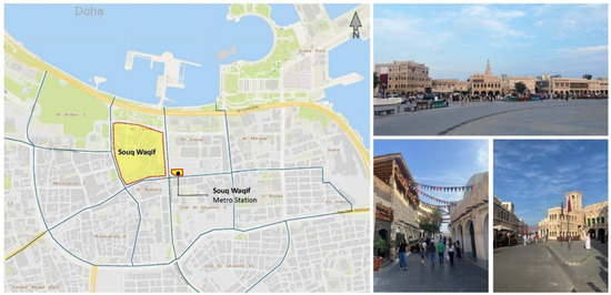
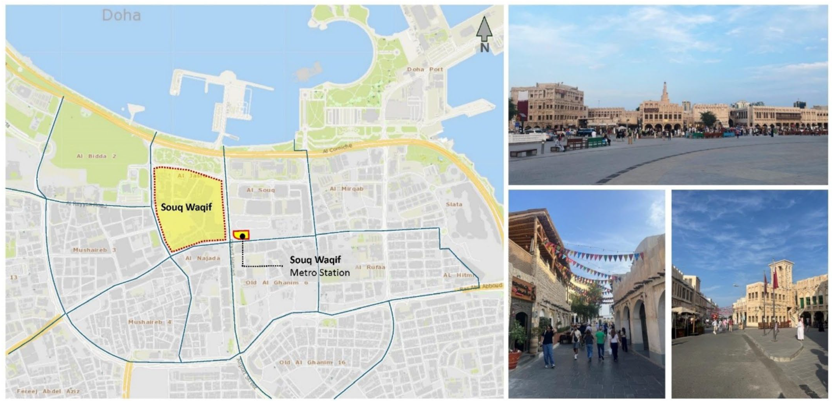
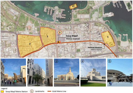
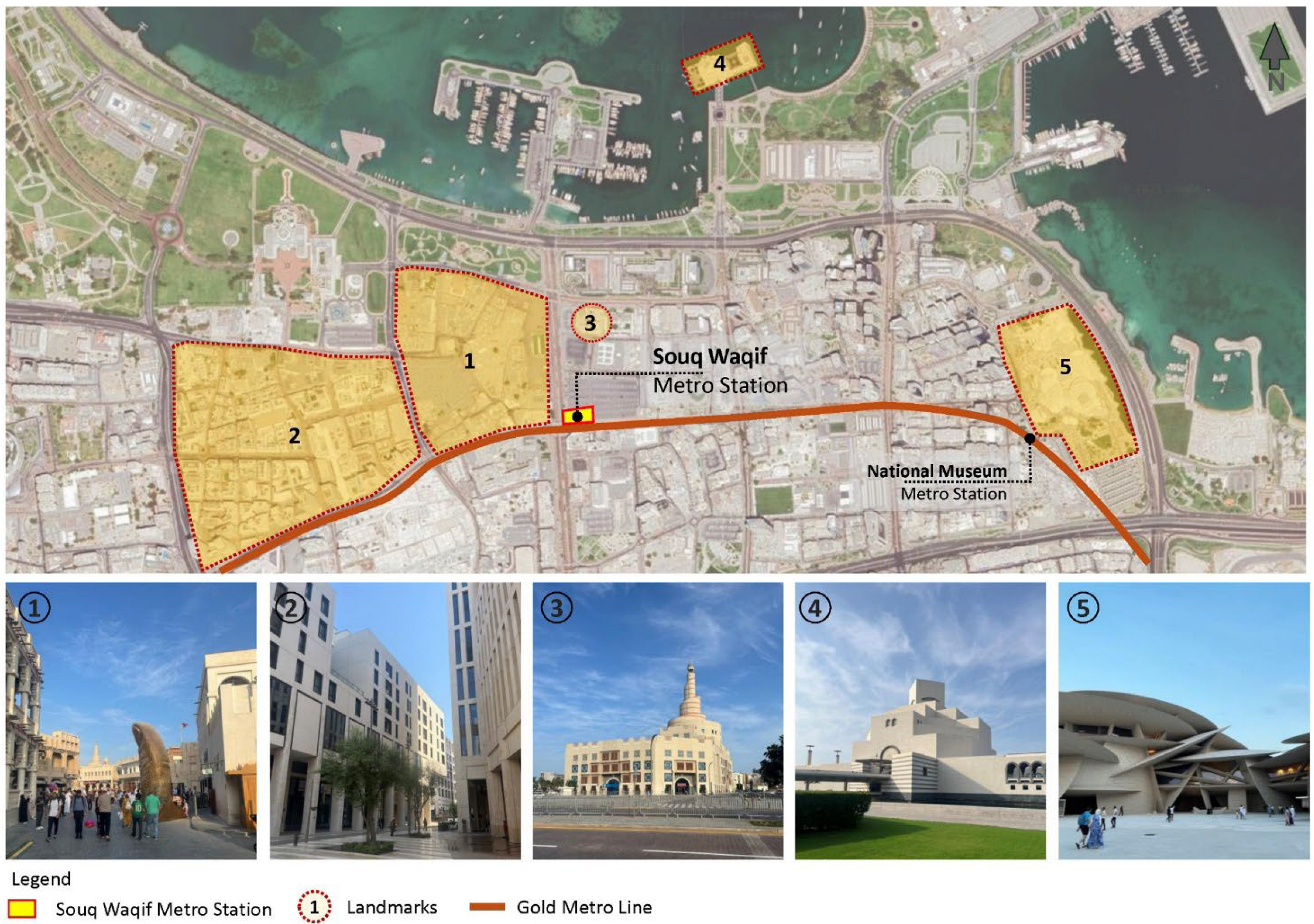
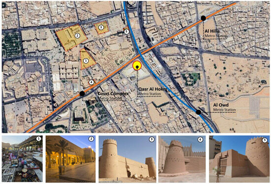
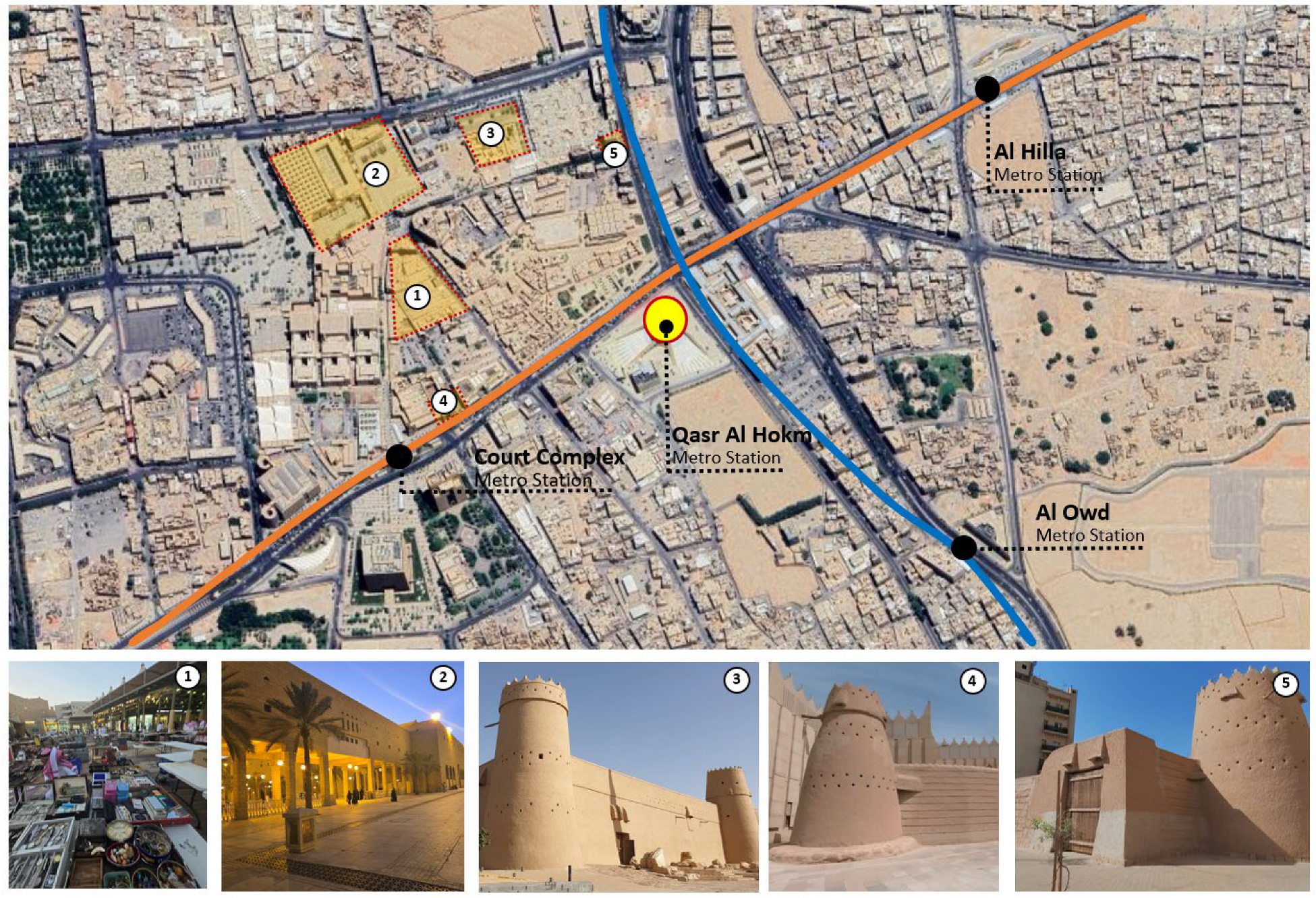
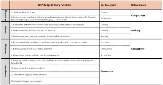
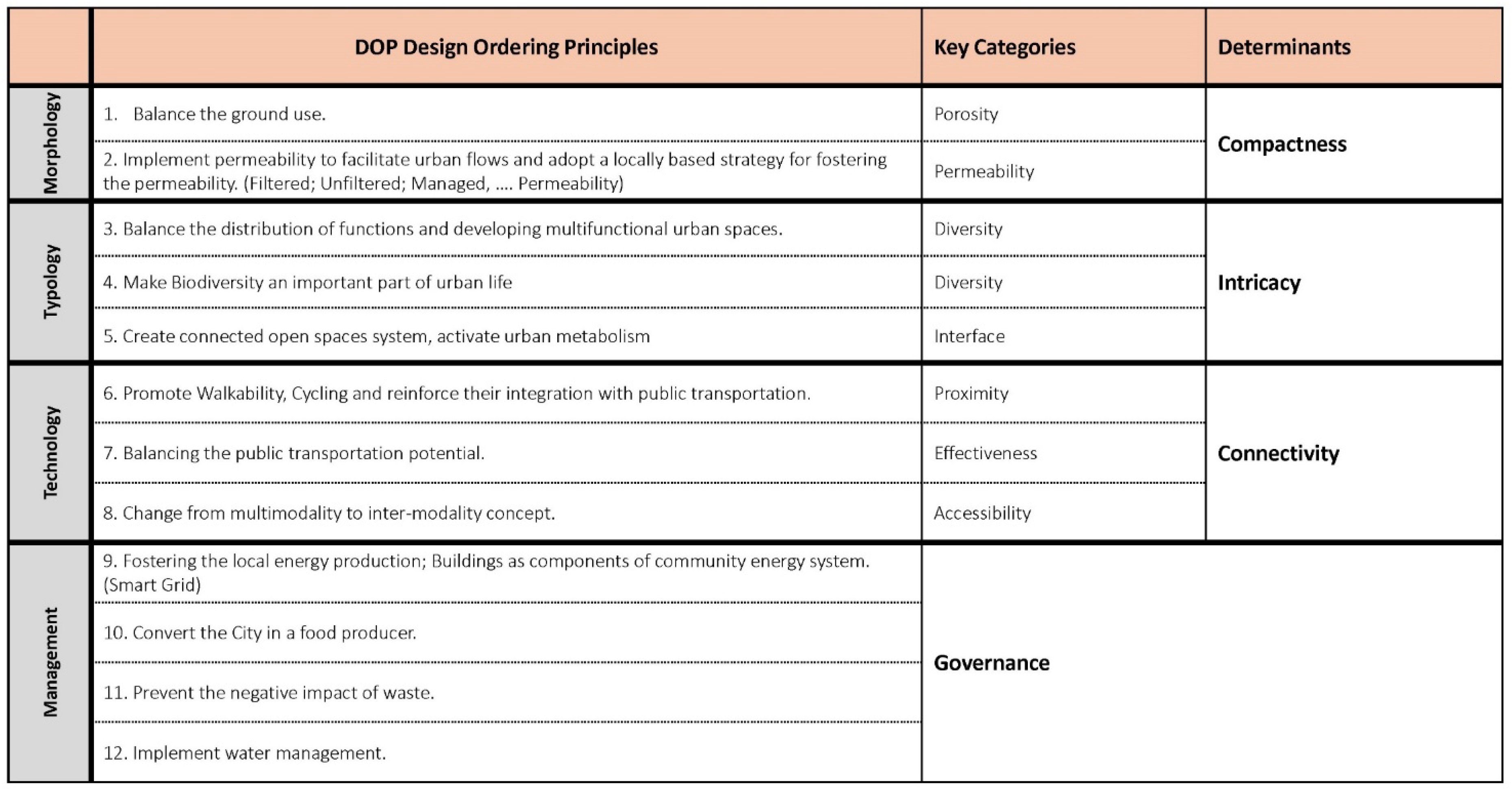
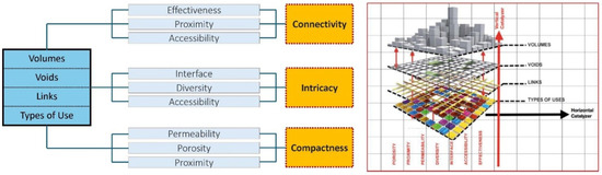
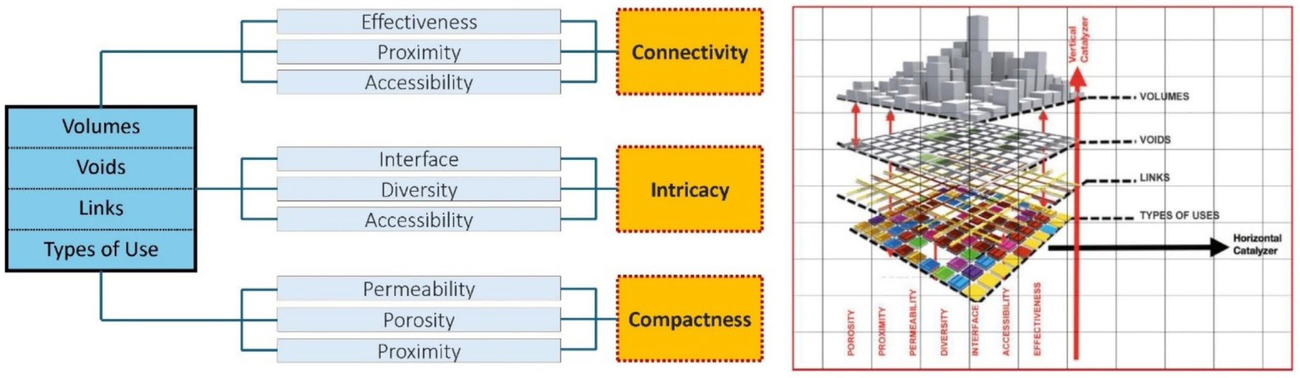
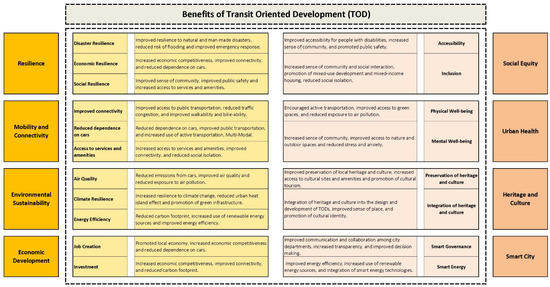
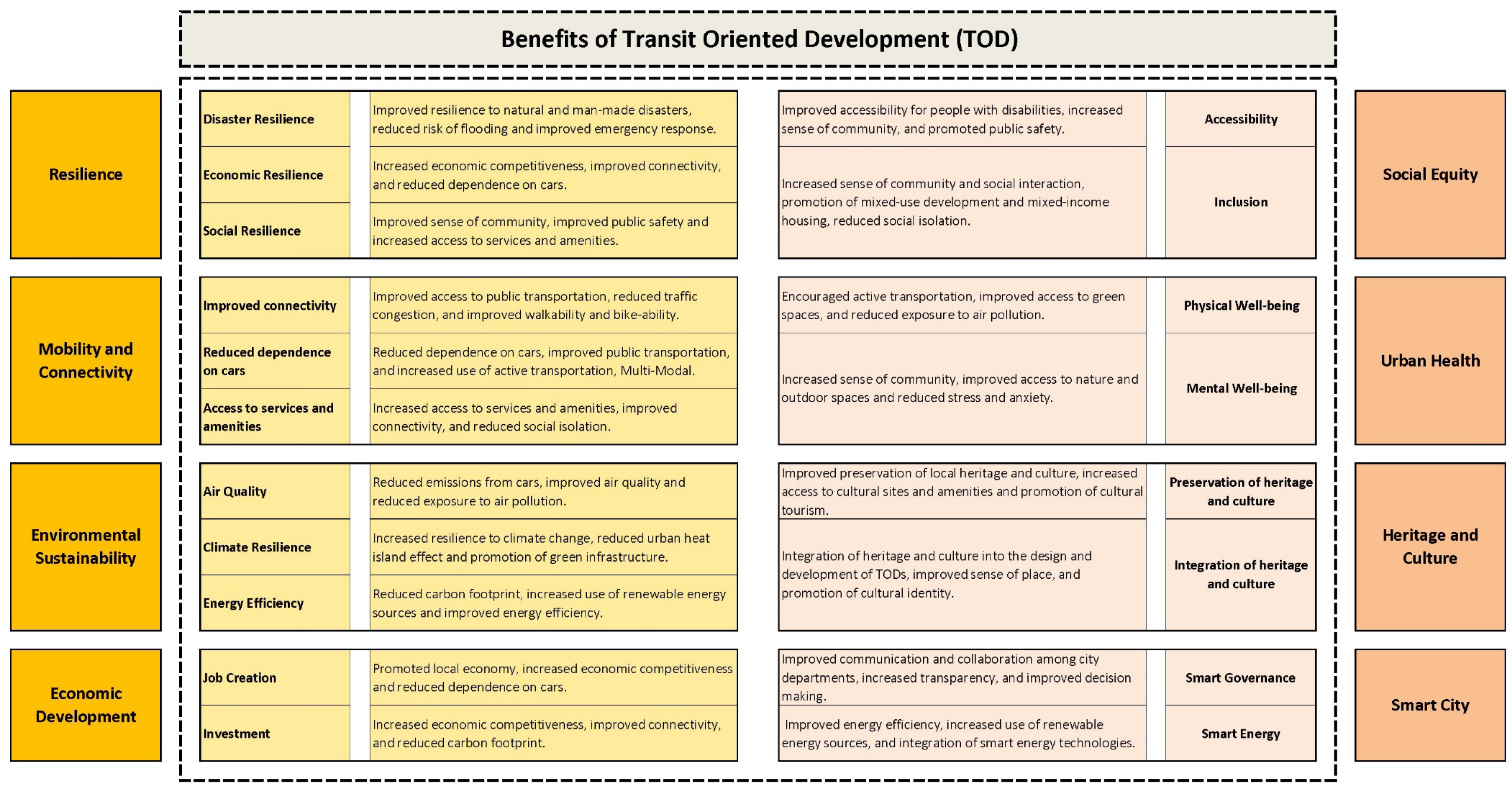
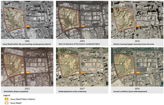
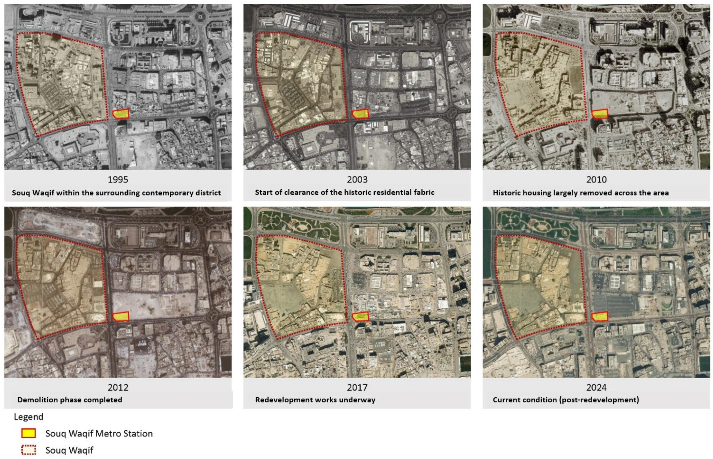
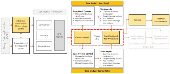
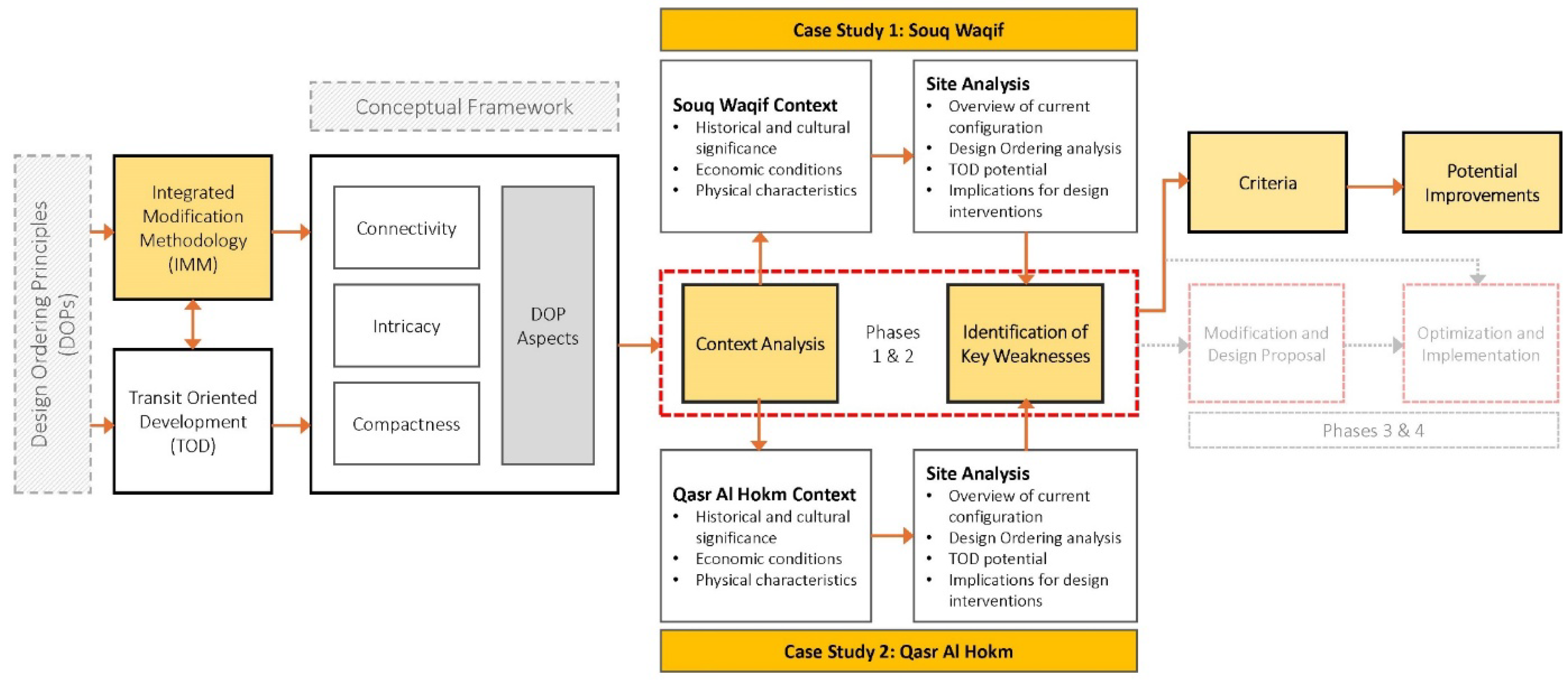
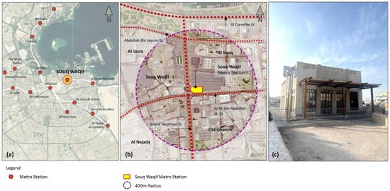
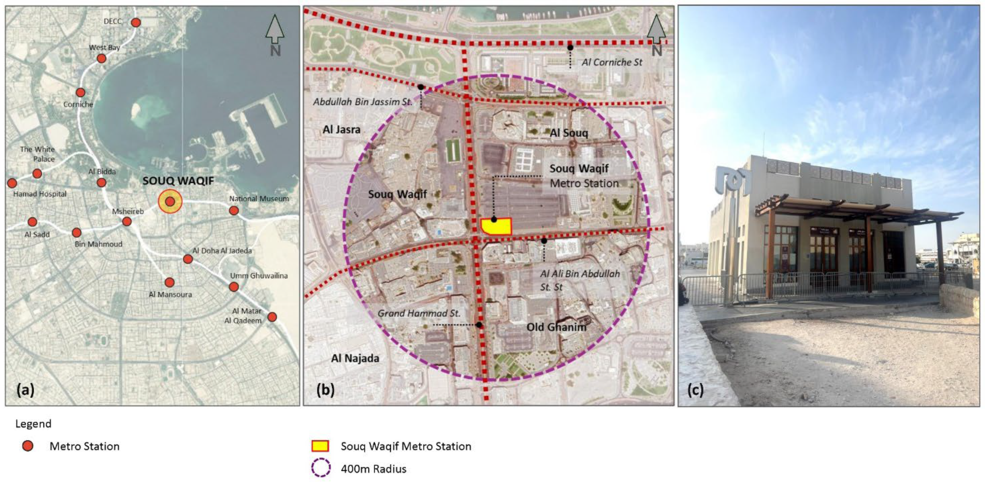
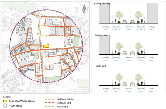
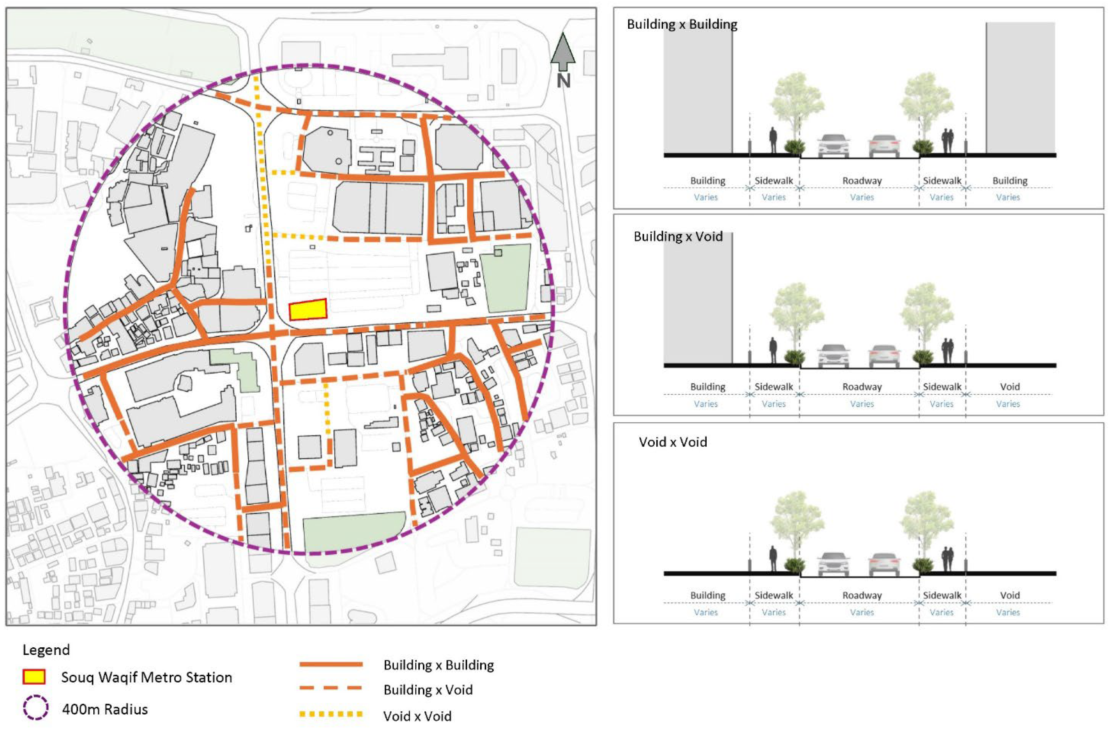
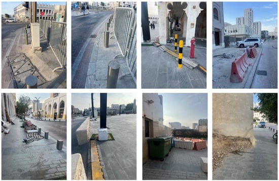
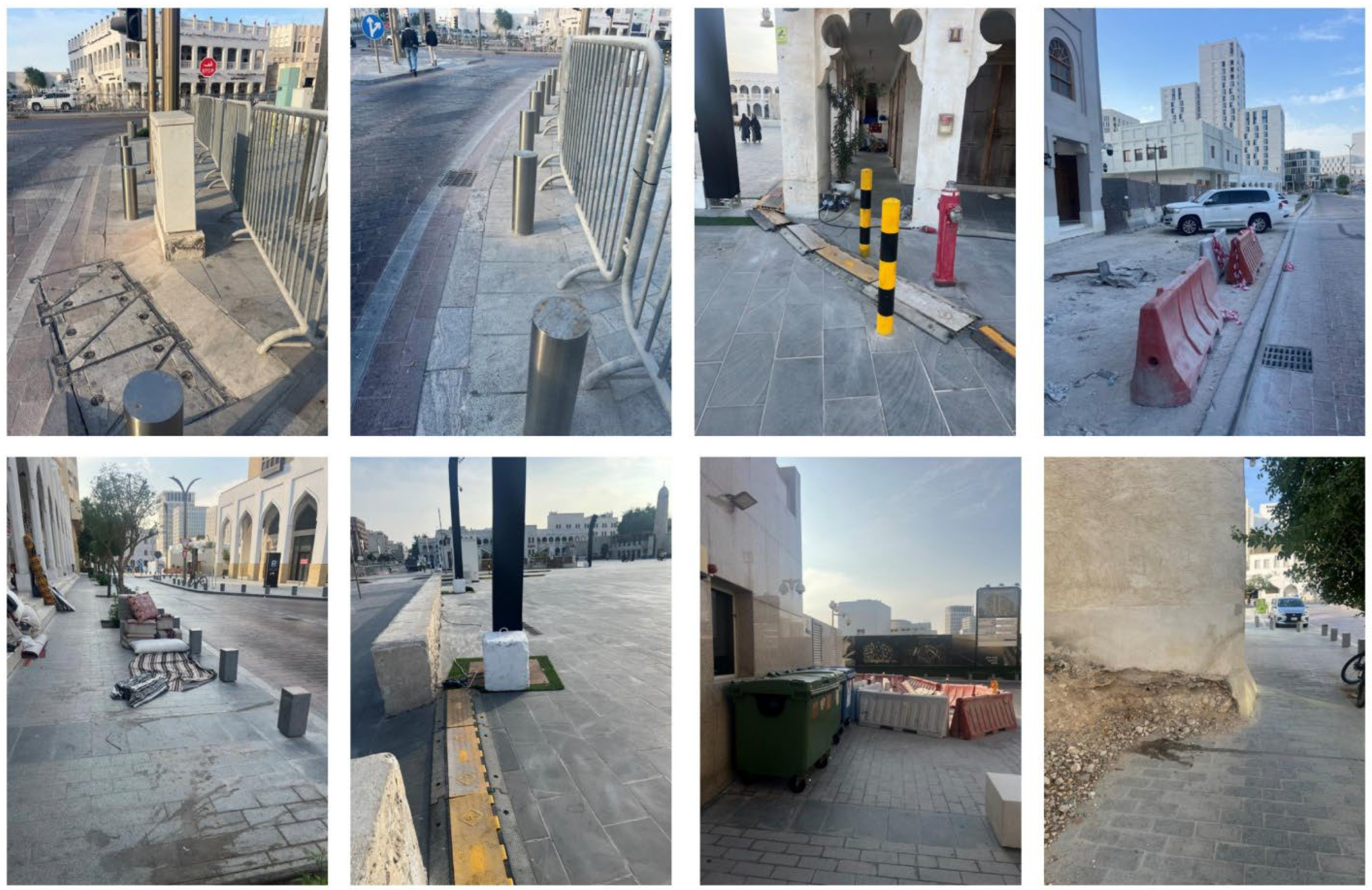
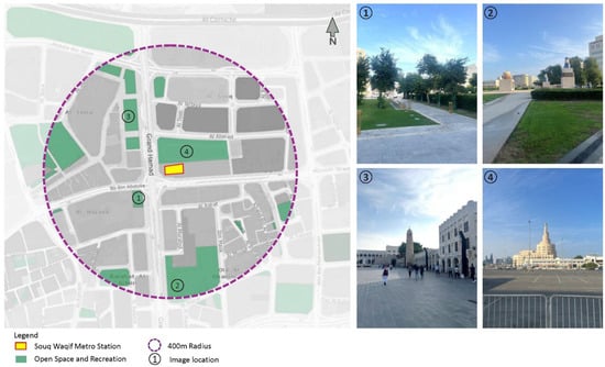
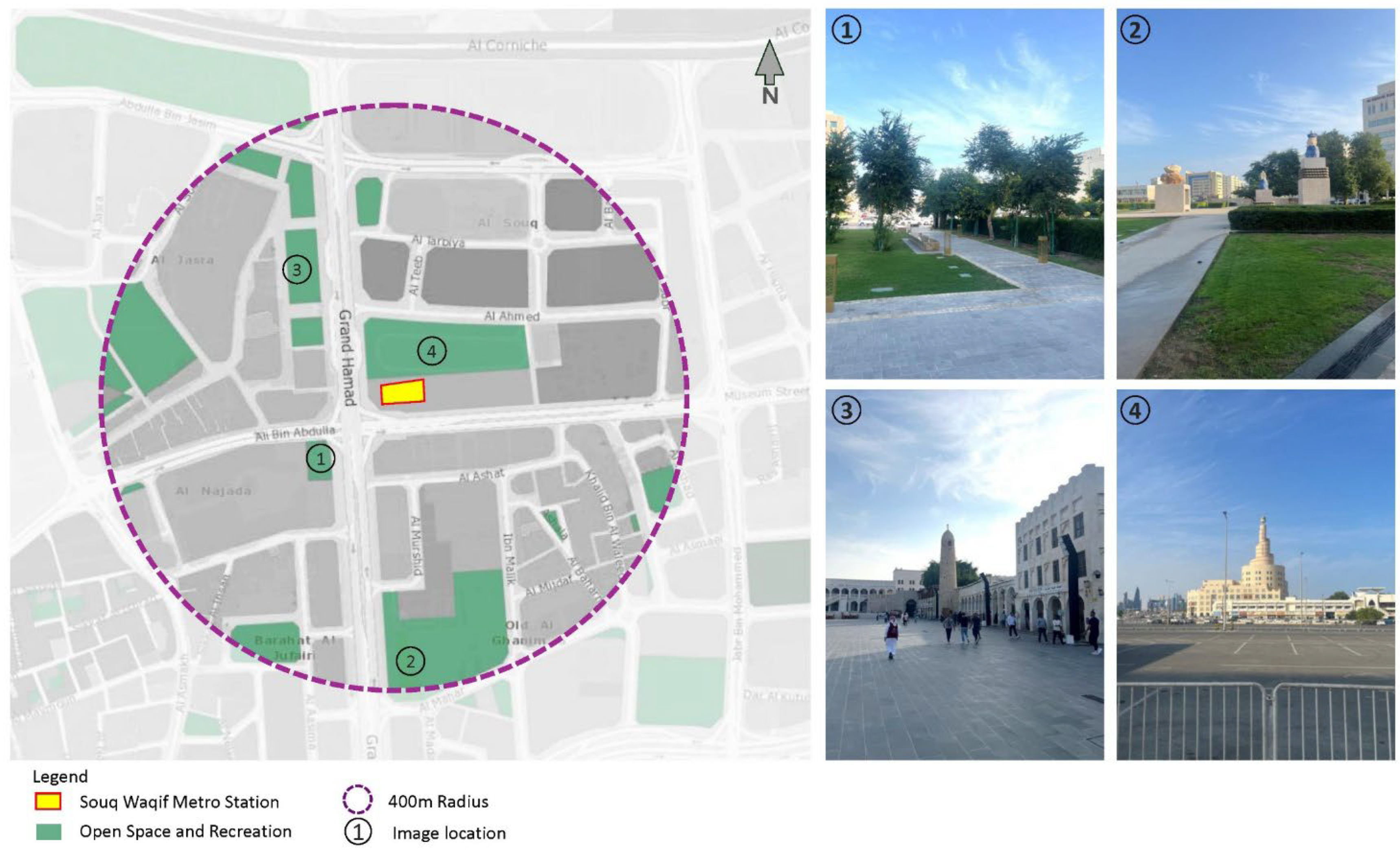
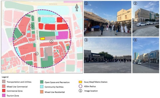
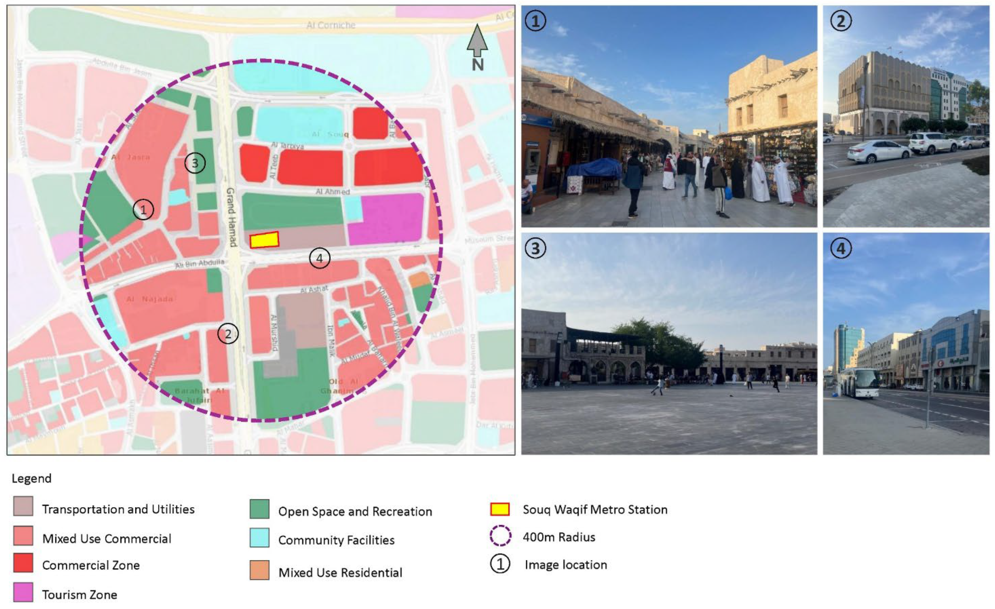
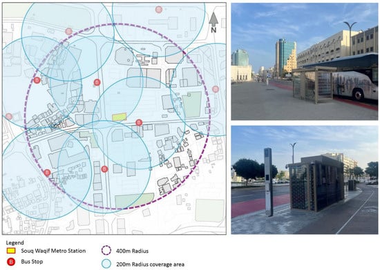
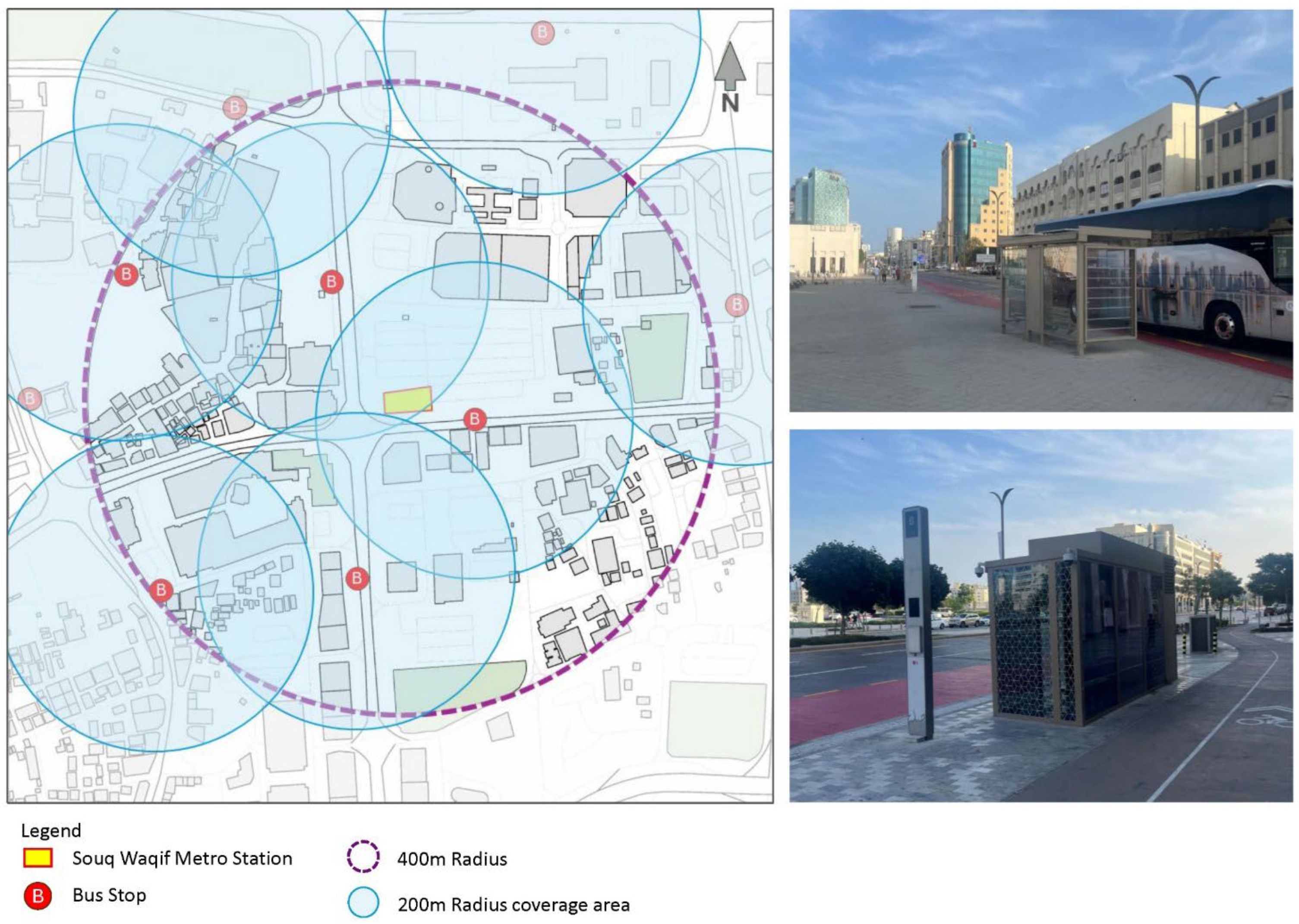
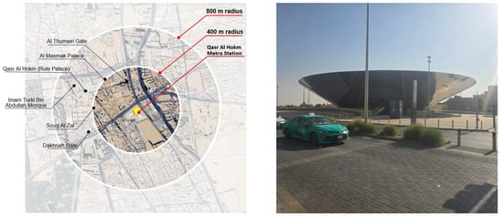
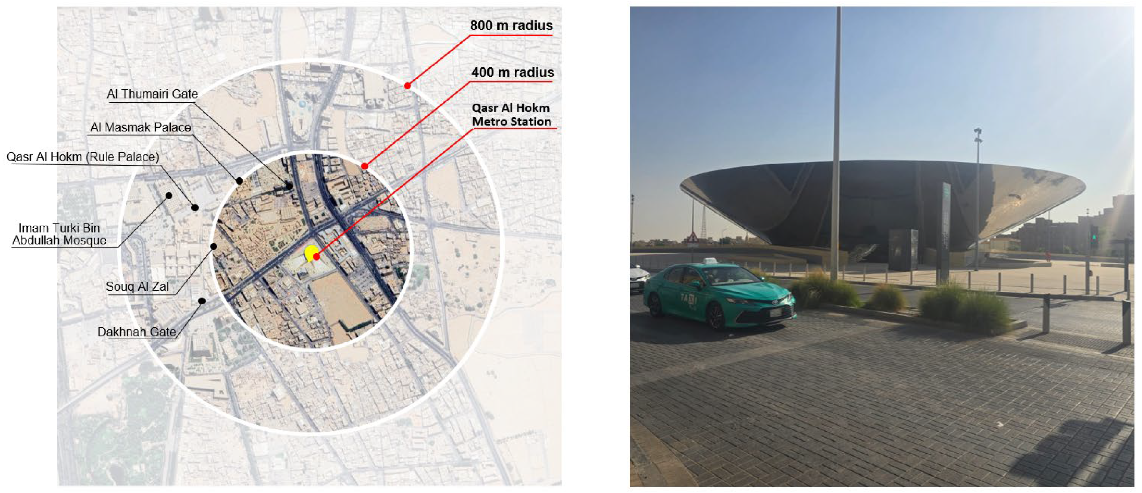
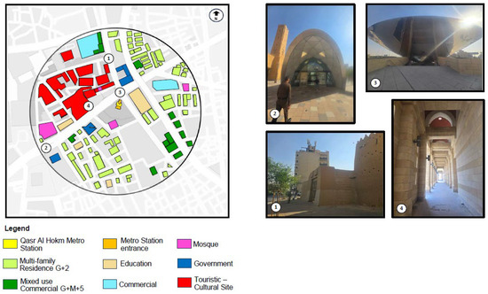
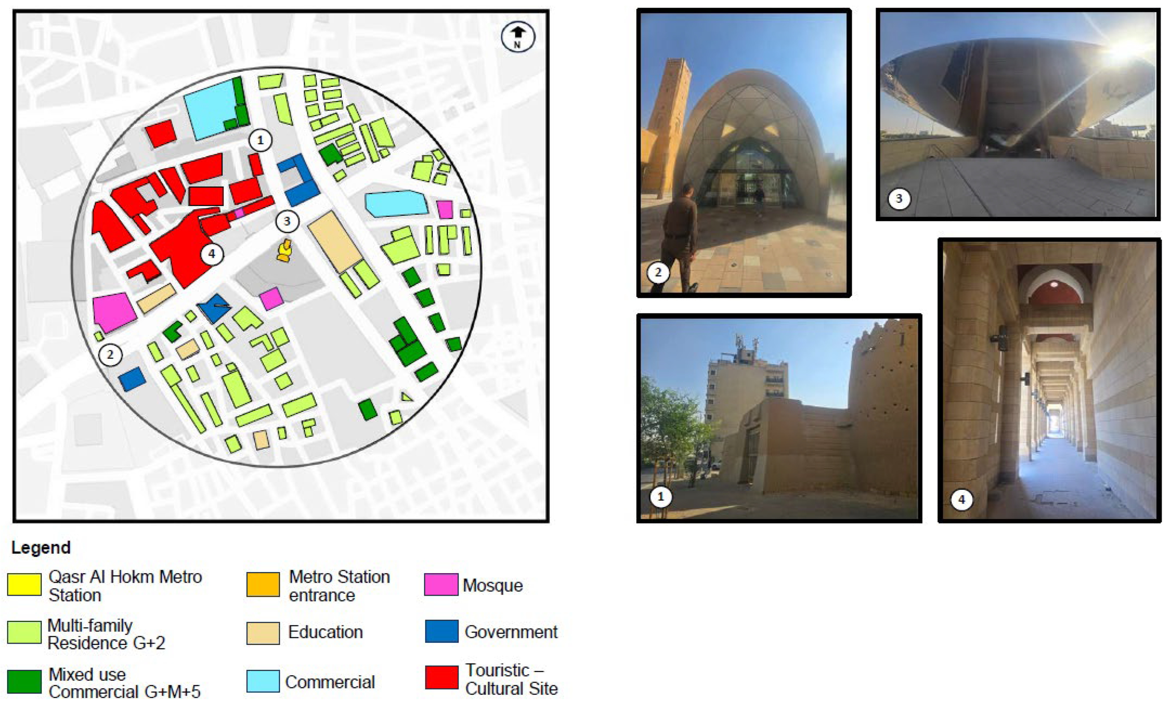
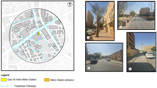
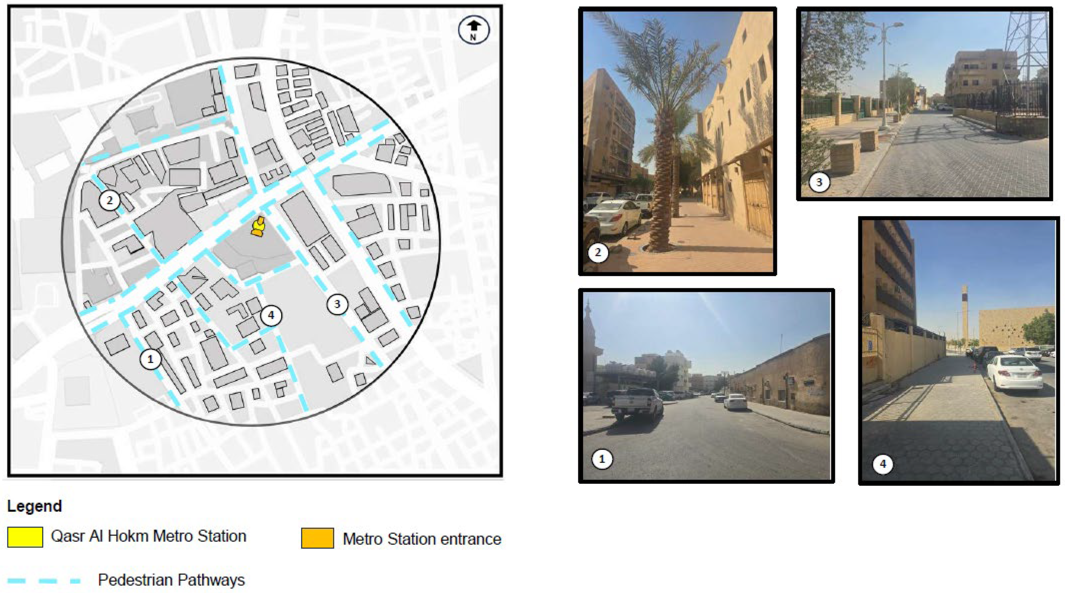
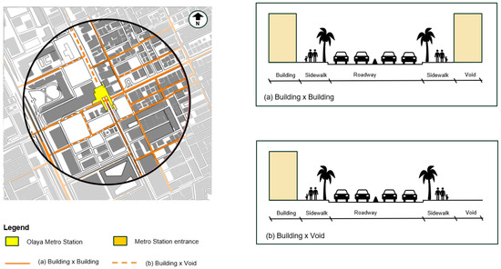
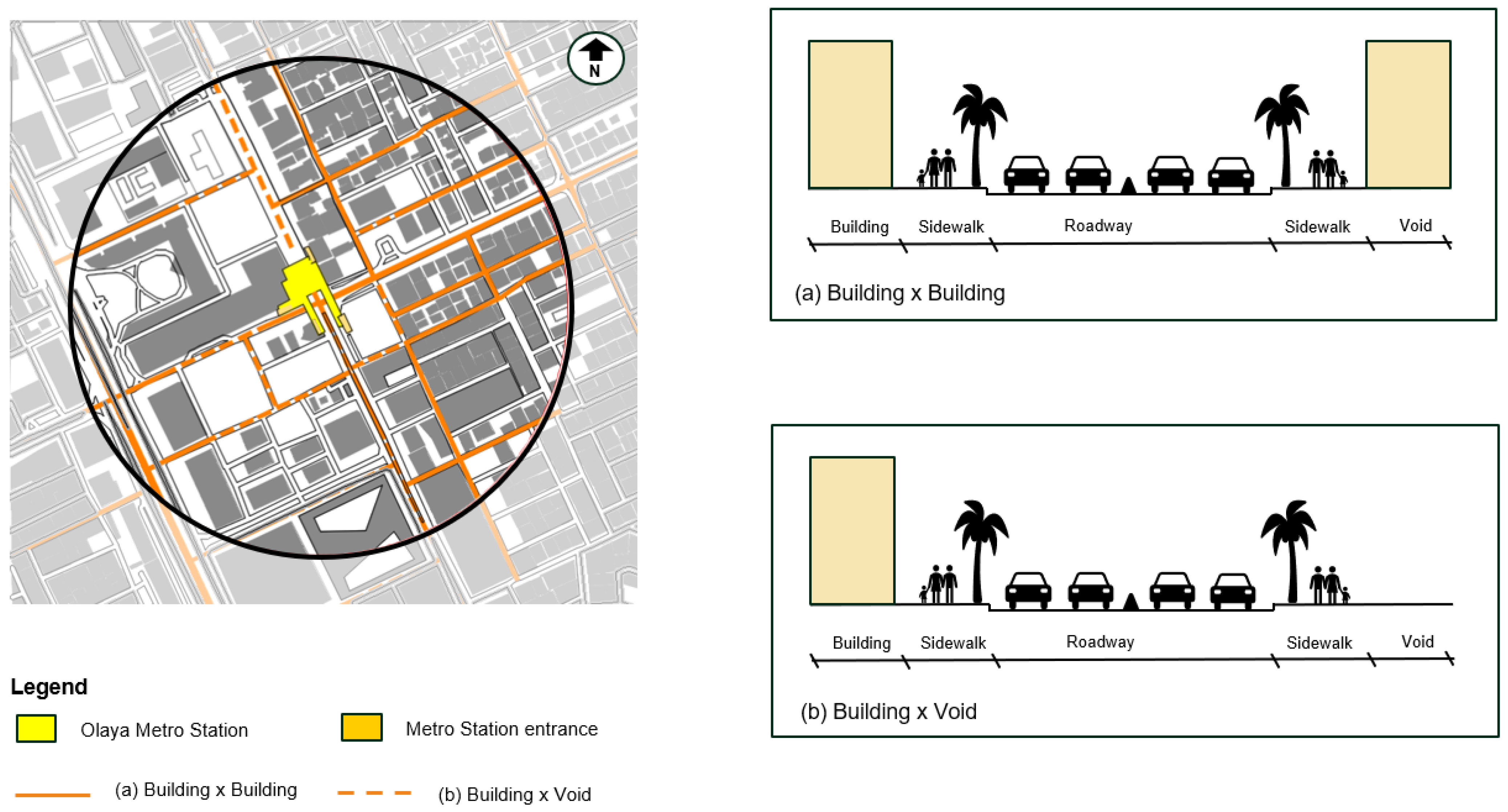
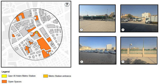
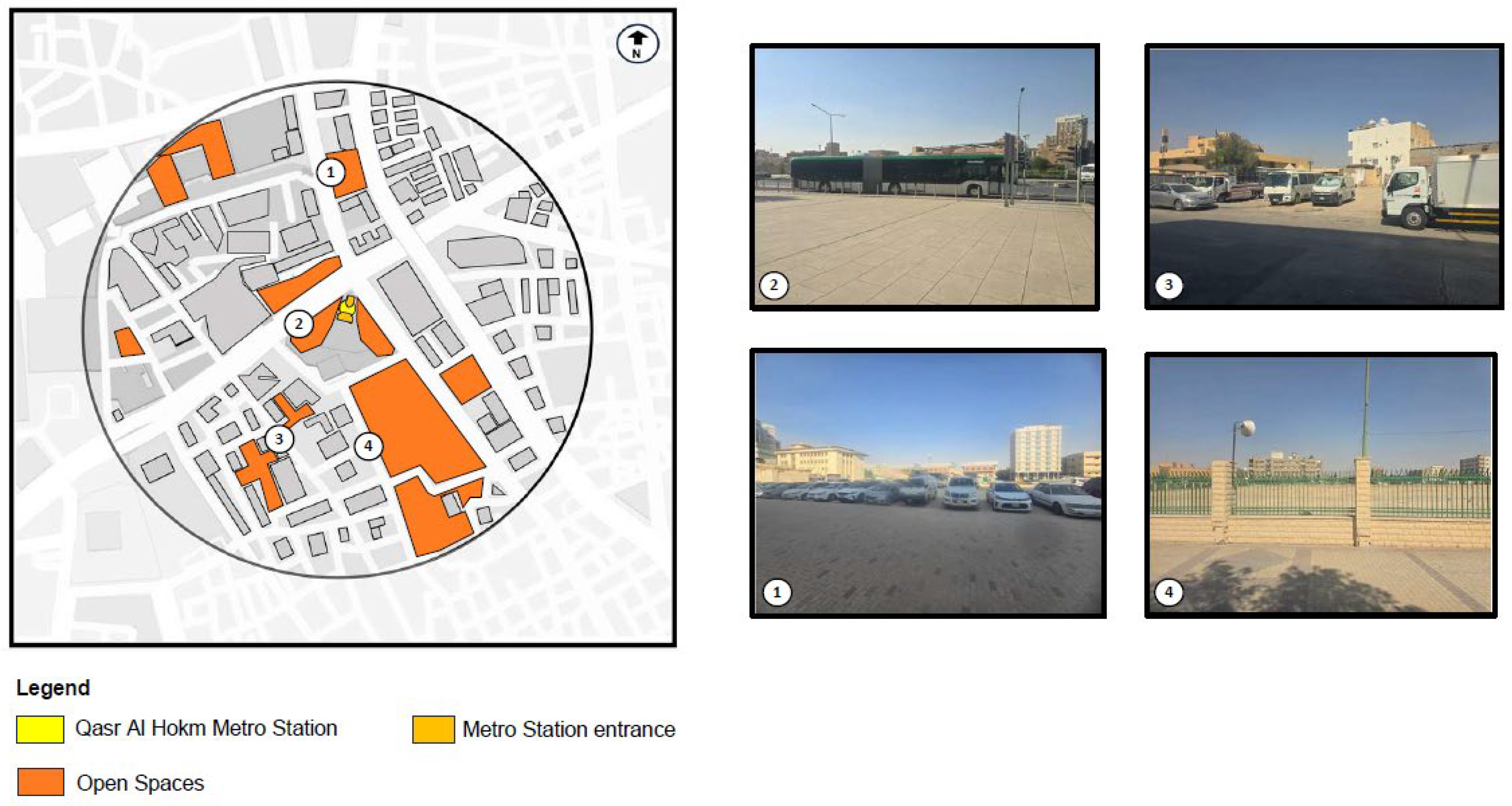
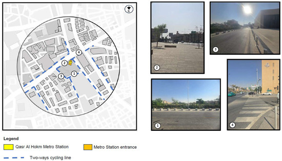
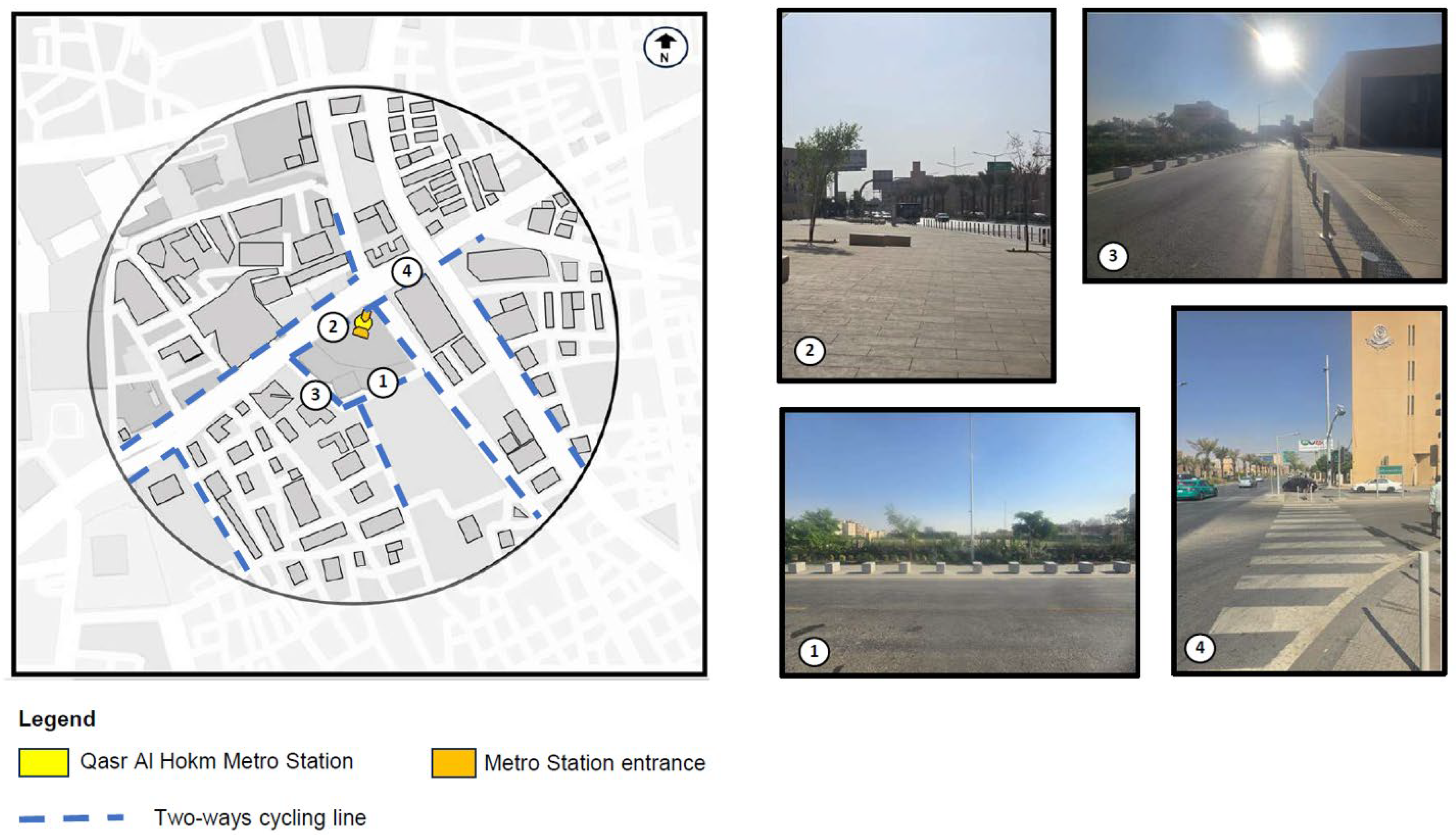
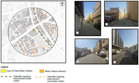
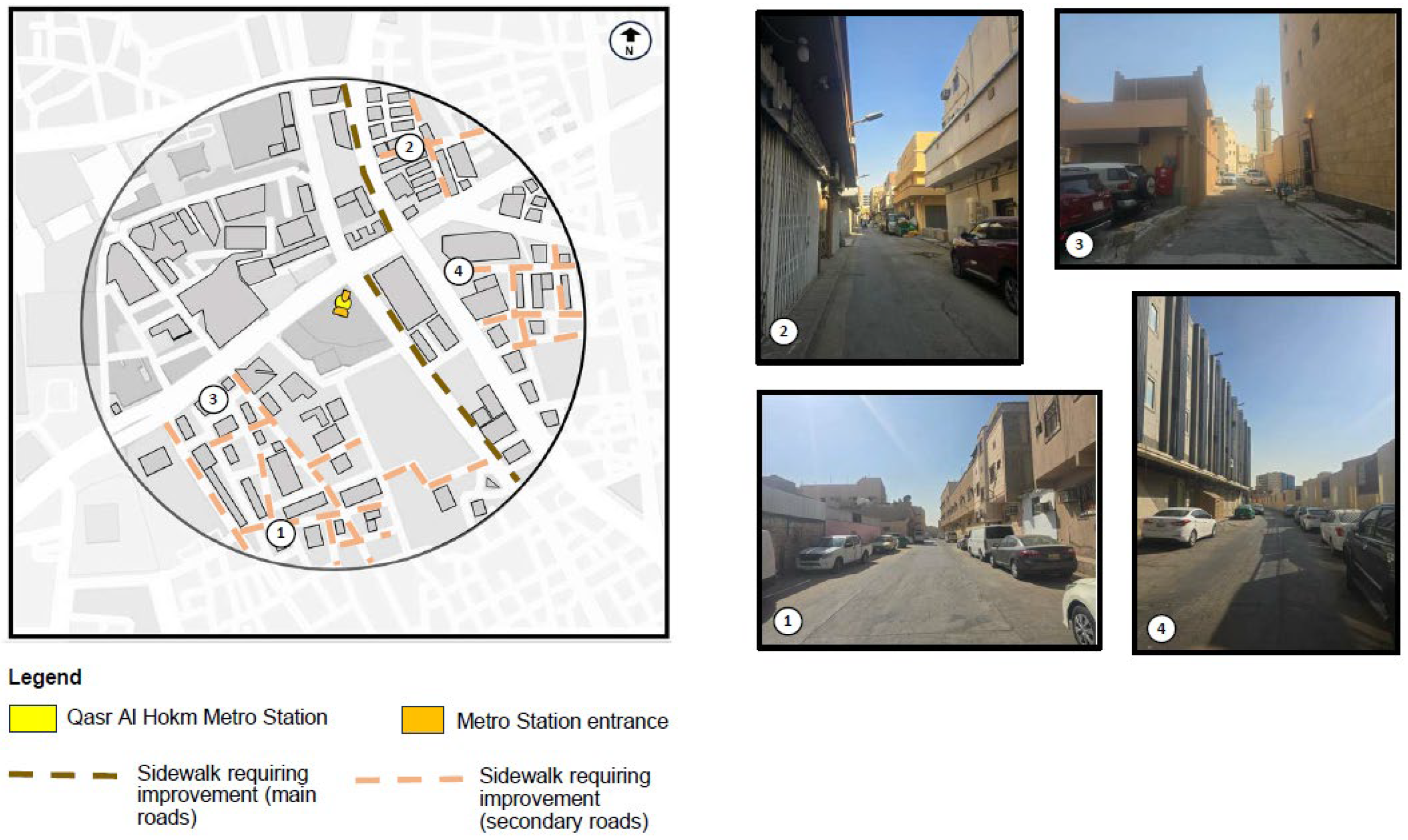
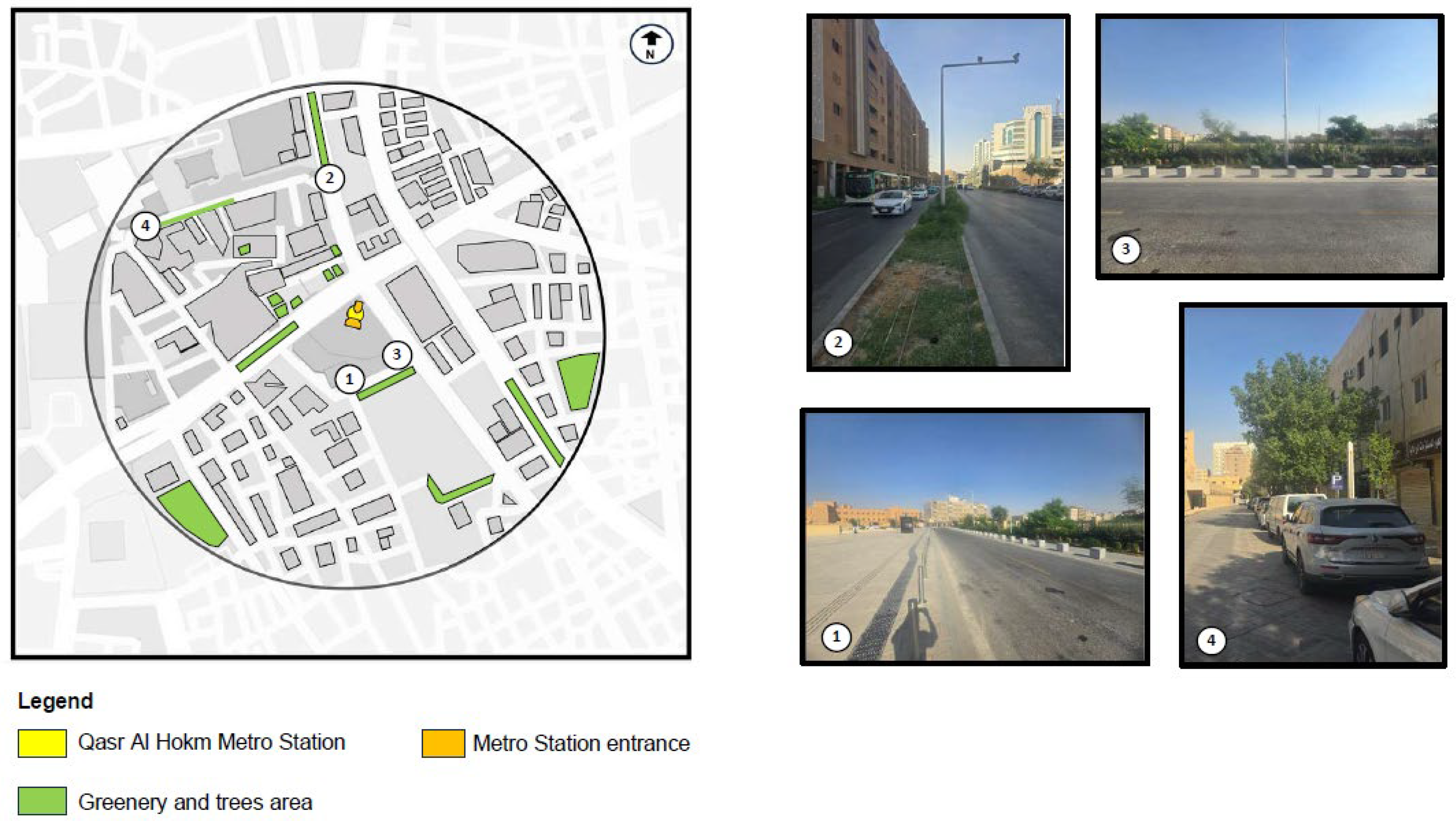
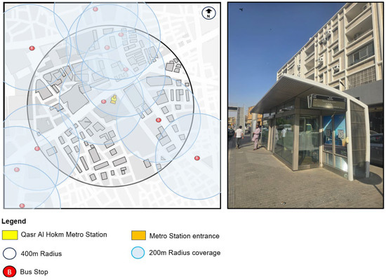
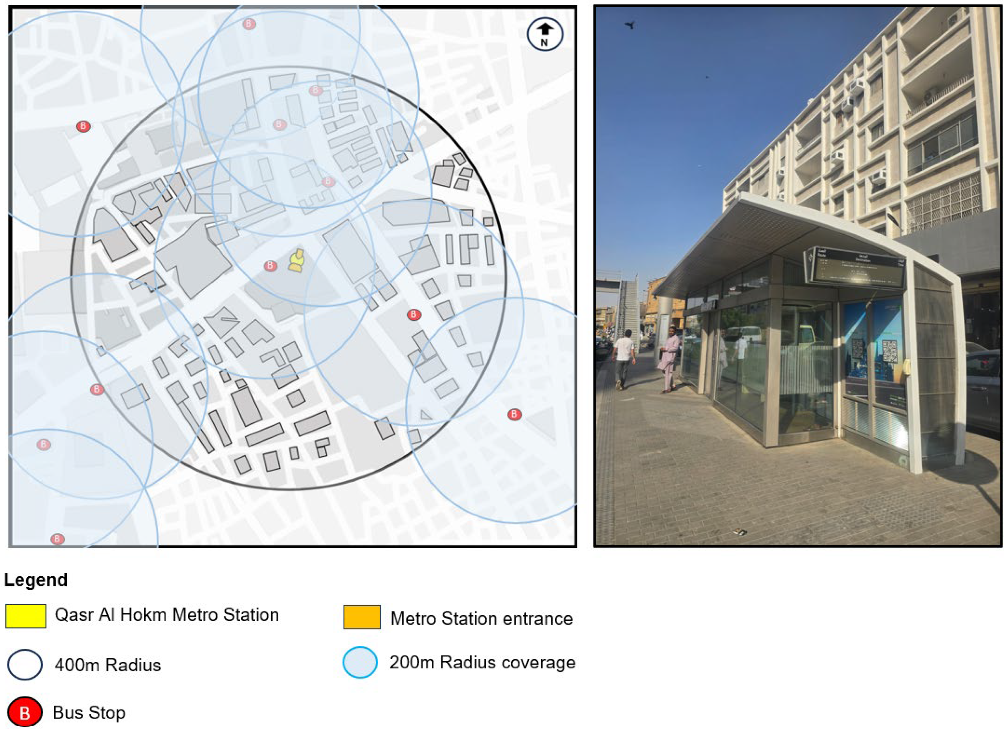

Disclaimer/Publisher’s Note: The statements, opinions and data contained in all publications are solely those of the individual author(s) and contributor(s) and not of MDPI and/or the editor(s). MDPI and/or the editor(s) disclaim responsibility for any injury to people or property resulting from any ideas, methods, instructions or products referred to in the content. |
© 2026 by the authors. Licensee MDPI, Basel, Switzerland. This article is an open access article distributed under the terms and conditions of the Creative Commons Attribution (CC BY) license.