


Abstract
In practice, village planning often suffers from an “emphasis on plan preparation but neglect of implementation”, a challenge that is especially evident in Sichuan Province, China, where highly diverse landforms and uneven development foundations make one-size-fits-all evaluation approaches difficult to apply. This study aims to develop a locally adaptable and operational method to quantify village planning implementation effectiveness control, enabling cross-type comparison and bottleneck diagnosis. We construct a three-level indicator system spanning eight domains—baseline control, land-use layout and construction, ecological protection and restoration, industrial development, infrastructure, public service facilities, living environment, and disaster prevention and mitigation—and determine indicator weights using the Analytic Hierarchy Process (AHP). To capture both compliance and progress, a dual-path scoring strategy is employed: constraint-based indicators are assessed using a threshold method by comparing current values (T1) with planning standards/thresholds (T2), while expectation-based indicators adopt a progress-ratio method incorporating baseline values before plan preparation (T0), current status (T1), and targets (T2). Three representative villages—Gaohuai (peri-urban integration), Sanlongchang (agglomeration and upgrading), and Lianmeng (characteristic protection)—are examined. Results show medium-to-high comprehensive scores (81–85) with pronounced type differences: Gaohuai ranks highest (85.37), whereas Sanlongchang is lowest (81.40), and Lianmeng is intermediate (83.71). Comparative diagnosis reveals shared bottlenecks driven by the superposition of “quota–space–ecological constraints”, alongside type-specific weaknesses requiring differentiated control strategies. The proposed framework offers a replicable, multi-source-data-oriented tool for implementation monitoring and adaptive policy adjustment. The novelty lies in reframing village plan implementation evaluation as implementation control effectiveness under a baseline-constrained planning system, while operationalizing a dual-path, unified-scale scoring scheme with a type-screenable indicator library for cross-type comparison and checklist-oriented diagnosis.
1. Introduction
Rural planning has long been criticized for “emphasizing preparation while neglecting implementation”: substantial effort is devoted to producing planning blueprints, yet systematic monitoring and evaluation of implementation processes and effects remain limited [1,2]. A growing body of evidence shows that implementation performance is tightly linked to plan legitimacy and real-world development outcomes; without continuous tracking and supervision, even well-designed plans may fail to resolve practical rural problems [3]. This challenge is particularly salient in Sichuan Province, where highly diverse geomorphology and marked socioeconomic disparities produce strongly differentiated village development conditions [4,5]. In particular, Sichuan’s “high-mountain–deep-valley–hilly–plain” landform mosaic and strong vertical zonation are coupled with frequent multi-hazard disturbances and dispersed, small-scale settlements, which jointly reshape construction suitability, infrastructure costs, and the enforceability of control rules across villages. Under such heterogeneity, uniform implementation measures are often ineffective. Therefore, an evaluation approach tailored to local contexts is needed to assess village plan implementation control, i.e., whether mandatory spatial constraints are complied with and whether planned actions progress toward targets in a traceable and comparable manner.
Moreover, China’s recent transition toward a unified Territorial Spatial Planning (TSP) system has changed the institutional “rule set” for village planning implementation and, in turn, raises new requirements for implementation evaluation [6]. Under the TSP framework, village plans are increasingly expected to operate as regulatory instruments that translate bottom-line constraints and spatial governance objectives into enforceable controls and project lists [7]; accordingly, implementation evaluation needs to simultaneously check (i) conformance to mandatory spatial control elements and (ii) performance toward development targets and public-service improvements [8]. This coupling of “rigid constraints + development actions” makes village plan implementation evaluation more complex in Sichuan, because the binding force and practical feasibility of controls vary sharply among mountainous, hilly, and plain/urban-fringe areas, and the same control item may require different thresholds, monitoring data, and enforcement pathways [9].
Urbanization has also intensified urban–rural disparities in many developing countries, making urban–rural integration a widely adopted policy direction [10,11,12]. In China, pronounced gaps in income, infrastructure, and public services persist even within megacity regions, reinforcing an urban–rural dual structure [13,14,15,16]. Accordingly, urban–rural integration has been elevated as a strategic priority worldwide and in China’s new-type urbanization and rural revitalization agendas [17,18,19,20]. Existing studies have (1) constructed indicator systems to measure urban–rural integration levels and spatial differentiation [21,22], (2) examined institutional and governance mechanisms shaping integration, including land-system duality and governance fragmentation [23,24], and (3) advocated a shift from purely regulatory planning toward development-oriented approaches that enhance rural autonomy [25]. Meanwhile, research on rural revitalization implementation highlights governance and coordination barriers and calls for stronger policy integration and implementation capacity [15,26,27,28]. These discussions collectively underscore a practical need: village plans must be evaluated not only by their stated objectives but also by how effectively they are implemented and controlled in diverse local settings such as Sichuan.
Plan implementation evaluation has developed from policy execution and project evaluation traditions. Pressman and Wildavsky’s seminal work emphasized that evaluation should examine how implementation unfolds, what outcomes are achieved, and which factors shape implementation [29]. Subsequent planning studies have operationalized evaluation through conformance and performance perspectives, assessing the degree of alignment between actual land use and planning intentions and the socioeconomic impacts of plan execution [30,31,32,33,34,35,36,37]. However, spatial planning differs from many policy domains because outcomes are reflected not only in policy indicators but also in spatial patterns and the built environment [38]. Therefore, scholars argue that implementation evaluation should move beyond binary success–failure judgments and instead scrutinize implementation behaviors and multidimensional effects [39,40,41]. Recent research on territorial and urban–rural plan implementation has expanded rapidly, often focusing on physical-space transformations [2,42,43]. In the context of TSP reform, implementation evaluation is increasingly framed as an iterative governance loop that links monitoring, evaluation, and plan adjustment, and scholars also emphasize that integrating conformance and performance lenses can yield a more diagnostic understanding of why implementation succeeds or fails [44,45]. Common frameworks include outcome-oriented approaches centered on target attainment and process-oriented approaches grounded in implementation behaviors; importantly, different lenses can yield different interpretations of the same implementation result [46]. Developing robust and operational approaches to evaluate planning implementation thus remains a key task—especially for village planning where control requirements are explicit and implementation conditions are highly uneven.
Methodologically, multi-indicator comprehensive evaluation and spatial monitoring tools provide a foundation for operationalizing implementation assessment. AHP and TOPSIS are widely adopted for weighting and multicriteria decision-making in rural sustainability, livability, and comparative development evaluations [47,48,49,50,51], and are often combined with Delphi, entropy methods, and related techniques to balance expert judgment and data-driven evidence [52,53,54]. TOPSIS has been applied to composite ranking and comparative assessments of rural development and settlement suitability [55,56]. GIS and RS have become essential for monitoring planning implementation by linking indicators to spatial locations, diagnosing land-use patterns and facility allocation, and tracking land-cover and ecological changes over time [57,58,59,60,61,62,63]. Existing studies also span macro-to-micro scales, from national assessments to regional diagnostics and village/community-level evaluations engaging practice contexts [49,64,65]. Together, these advances suggest a mainstream technical route—multicriteria evaluation supported by multi-source spatial data—that can be adapted to Sichuan’s village planning implementation effectiveness control.
Despite extensive research, three gaps remain for village planning implementation effectiveness control evaluation in Sichuan. First, many evaluation systems show limited local adaptability: indicators and models are often transferred from national templates or other regions and may not fit Sichuan’s distinctive physical and socioeconomic conditions. Second, governance- and process-related aspects of implementation are frequently discussed but are difficult to operationalize; existing systems therefore tend to emphasize measurable “hard” outcomes while paying less attention to implementation processes and monitoring logic. Third, dedicated assessment of the control dimension within implementation is still insufficient: many studies focus on outcomes but provide limited evaluation of how land use and construction behaviors are regulated against planning constraints during implementation. These gaps motivate this study to develop an implementation effectiveness control evaluation method suitable for Sichuan’s heterogeneous village contexts, strengthen process monitoring, and provide decision support for effective plan realization under the rural revitalization strategy.
2. Materials and Methods
This study establishes a complete methodological system covering indicator system development, data acquisition, weight determination, and comprehensive evaluation. Following the principles of classification guidance and zoning adaptation, typical village cases are selected. A qualitative–quantitative combined approach is adopted to construct an AHP-based evaluation framework for village planning implementation effectiveness control. The study includes four core components: study area and sample selection, data sources, evaluation methods, and indicator system construction. The overall research framework is shown in Figure 1.
Figure 1.
Research framework.
2.1. Study Area and Sample Selection
Sichuan Province was selected as the study area due to its pronounced geographical heterogeneity, encompassing plains, hills, mountains, and plateaus, which result in highly diverse rural development conditions. Additionally, Sichuan’s rural revitalization strategy classifies villages into distinct types, providing a representative microcosm for examining planning implementation under varied socio-economic and environmental contexts.
To reflect Sichuan’s rural geographical features and development disparities, this study divides rural areas across the province based on the five major economic zones delineated in the Sichuan Provincial Territorial Spatial Plan (2021–2035): Chengdu Plain Economic Zone, Southern Sichuan Economic Zone, Northeastern Sichuan Economic Zone, Panxi Economic Zone, and Northwestern Sichuan Ecological Demonstration Zone. This zoning comprehensively considers natural geographic conditions, economic development levels, population distribution patterns, and the strength of urban–rural linkages, and can effectively reflect differences in resource endowments and control difficulties faced in planning implementation among regions.
Based on Sichuan’s regional development strategy, the above five-zone division, and the three rural types proposed in the Sichuan Provincial Rural Revitalization Strategic Plan (2018–2022)—peri-urban integration type, agglomeration and upgrading type, and characteristic protection type—this study preliminarily screened 22 sample villages (Table 1) following the principles of “classification guidance, zoning adaptation, planning coordination, and solid foundations”.
Table 1.
Preliminary screening of study villages.
On this basis, the Northwestern Sichuan Ecological Demonstration Zone and the Panxi Economic Zone were excluded. The reason is that the key control focuses of rural construction in these two regions differ by development stage from the objectives emphasized in this study of “classification guidance and intensive development”: the Northwestern Sichuan Ecological Demonstration Zone prioritizes ecological protection as its core function, and rural construction focuses more on ecological conservation than on intensive development; the Panxi Economic Zone emphasizes resource development and industrial transformation, focusing more on resource utilization and economic transition. These differences produce a relatively large gap from the research objectives, so these zones are not treated as focal types.
Considering that the Chengdu Plain Economic Zone has a high degree of urban–rural integration and active factor flows, the Northeastern Sichuan Economic Zone has strong population agglomeration potential and concentrated public service demand, and the Southern Sichuan Economic Zone has solid characteristic industry foundations and rich cultural resources, a “three rural types × typical economic zones” correspondence is established: “peri-urban integration type + Chengdu Plain Economic Zone”, “agglomeration and upgrading type + Northeastern Sichuan Economic Zone”, and “characteristic protection type + Southern Sichuan Economic Zone”. Finally, through field investigations, planning coordination analysis, and consideration of development foundations, three representative villages are selected as typical cases (Figure 2 and Table 2):
Figure 2.
Location map of three typical village types in Sichuan Province.
Table 2.
Classification of village types and representative case villages.
- Gaohuai Village, Longgao Area, Jingyang District, Deyang City (peri-urban integration type);
Located in the near suburbs of Deyang with convenient transportation, relatively complete surrounding infrastructure, and high population density. The village is a model of urban–rural integration. Relying on location advantages, it has developed an “agriculture–culture–tourism + innovation fields” industrial model, transforming from traditional agriculture to cultural and tourism formats featuring rural coffee and cultural/creative design brands, forming new consumption scenarios integrating leisure, art creation, and parent–child research activities, attracting urban residents and young entrepreneurs. It represents a typical case of two-way flow of urban–rural factors and deep integration of new formats.
- 2.
- Sanlongchang Village, Guihua Area, Shuanggui Town, Jialing District, Nanchong City (agglomeration and upgrading type);
Sanlongchang Village, Guihua Area, Shuanggui Town, Jialing District, Nanchong City (agglomeration and upgrading type): located in the central area of Jialing District and serving as the core zone of the mulberry–tea industry in the Guihua area, with advantageous location, increasing population agglomeration, and abundant land resources. In recent years, it has promoted land centralized transfer and park-based modern agricultural operations, aiming to develop scaled and intensive characteristic agriculture. It has foundational conditions for industrial and population agglomeration and upgrading and represents a typical village of this type in Northeastern Sichuan.
- 3.
- Lianmeng Village, Zhuhai Town, Taoping Area, Yibin City (characteristic protection type).
Located in the shallow hilly area in the hinterland of the Shunan Bamboo Sea National Tourist Resort in southern Yibin and serving as the core area of the Taoping rice–crayfish modern agricultural park in Changning County. The village has unique bamboo ecological landscapes and bamboo cultural heritage, retains traditional building textures and commercial cultural contexts, and has a solid agricultural base. Relying on natural and cultural resources, it promotes integrated development of the bamboo industry and ecotourism. It is a typical characteristic protection village that develops diversified industries by leveraging ecological resources and provides an example for agricultural modernization and rural revitalization in hilly and mountainous areas.
This study evaluates the latest current status of planning implementation for the three typical villages (denoted as T1). To quantify the implementation progress of expectation-based indicators in the progress-ratio scoring method, the baseline reference value before plan preparation (T0) and the planning target value (T2) are introduced. Together with T1, they are used to calculate progress scores; for constraint-based indicators, only T1 and T2 are used via the threshold-based method.
2.2. Data Sources
Data in this study are mainly from two sources. The first is statistical and spatial data, including the Sichuan Statistical Yearbook, annual county/district development reports (available at http://tjj.sc.gov.cn/), the Second National Land Survey data (available at https://gtdc.mnr.gov.cn/), land-use status databases, and high-resolution remote sensing imagery (provided by Sichuan Institute of Geological Survey). These support quantification of indicators such as cultivated land protection, ecological resources, infrastructure, and industrial development, and are used for spatial overlay analysis, land-use change comparison, and identification of ecological protection scopes. The second is planning documents (provided by local governments) and field survey data, including planning texts and drawings for typical villages, thematic maps, status survey reports, as well as interviews with local governments, township departments, and village committee staff, and villagers’ questionnaires and oral materials. Planning texts are used to extract development goals, spatial layouts, project lists, and control redlines; field surveys are used to verify planning implementation and supplement information on public services, industrial project delivery, and homestead consolidation.
2.3. Evaluation Methods
2.3.1. Indicator Standardization
To ensure that the comprehensive evaluation system can effectively integrate multi-source data, it is necessary to address incomparability caused by inconsistent units and magnitudes among indicators. Therefore, the collected raw data are standardized to provide a foundation for subsequent comprehensive score calculation and comparative analysis, ensuring scientific rigor and comparability. The indicator system constructed in this study is based on planning documents with clear policy orientations. Thus, each indicator carries a specific policy goal: either a mandatory baseline to be followed or an expected direction of achievement. Therefore, during the evaluation, all indicators can be clearly categorized into positive, negative, or interval-type constraints. For different properties of constraint-based and expectation-based indicators, the threshold-based method and the progress-ratio method are used respectively, and all indicator scores are normalized to a 0–100 scale.
For constraint-based indicators (rigid targets that must be met in the plan, including upper-bound, lower-bound, and interval types), scoring adopts a threshold-based method by comparing the current value T1 with the target value T2 to determine compliance. When the current value does not meet the standard, a base score of 60 is assigned and deductions are made according to the proportion of non-compliance. When the standard is met, scoring starts from 80 and bonus points are added based on the proportion by which the target is exceeded, up to a maximum of 100. This method reflects the degree to which rigid planning constraint indicators are implemented.
For expectation-based indicators (guiding targets expected to be achieved in the plan, including positive and negative indicators), scoring adopts a progress-ratio method using T0 (baseline), T1 (current), and T2 (target). For positive indicators, if T1 reaches or exceeds T2, the score is 100; otherwise, the score is calculated as:
For negative indicators (e.g., pollutant emissions required to decrease), if T1 reaches or is better than T2, the score is 100; otherwise, the score is calculated as:
In this evaluation framework, there is no specific category for neutral indicators, as all indicators are tied to either compliance with required targets (constraint indicators) or achievement of expected goals (expectation indicators).
2.3.2. Indicator Weight Allocation
The Analytic Hierarchy Process (AHP) was selected to determine indicator weights, primarily for the following reasons. First, evaluating rural planning implementation is a multi-criteria decision-making problem that involves both quantifiable “hard” indicators and qualitative “soft” dimensions, which require expert judgment. AHP effectively transforms qualitative expert judgments about the relative importance of planning objectives into quantitative weights through pairwise comparison matrices. This is particularly suitable for regions like Sichuan, which exhibit significant geographical diversity, as it allows the flexible integration of localized expert knowledge to reflect varying regional development priorities. Furthermore, AHP’s hierarchical structure aligns perfectly with the hybrid weighting strategy used in this study. It allows us to assign fixed weights to primary and secondary indicators while providing a flexible structure for selectively adopting and equally weighting tertiary indicators based on specific village plans.
In comparison to alternative methods, the Best-Worst Method (BWM) reduces the number of comparisons but lacks flexibility with complex, multi-level indicator systems; the Decision-Making Trial and Evaluation Laboratory (DEMATEL) is better suited for analyzing causal relationships rather than direct weighting; and purely data-driven methods like the Entropy Weight (EW) and CRITIC methods determine weights based on data variability or correlation, but they do not proactively incorporate policy priorities or expert value judgments, nor can they handle the flexible tertiary indicators in our framework.
The AHP model used in this study was structured with multiple layers: the objective layer, primary indicators, secondary indicators, and tertiary indicators. The weight determination process includes two stages. First, AHP expert scoring is used to determine weights for primary and secondary indicators to establish a stable and comparable evaluation framework across the province. Second, in applications to specific villages, tertiary indicators are selected according to the village’s actual planning content, and the weight of each chosen tertiary indicator was then calculated by equal allocation within its parent secondary indicator.
The steps are as follows:
Pairwise comparison matrix construction: based on expert judgments, a pairwise comparison matrix is constructed, where each element represents the importance of one indicator relative to another.
Consistency test: the consistency ratio (CR) is used to test matrix consistency:
where is the maximum eigenvalue of the matrix, is the number of indicators, and is the random consistency index associated with . If , the matrix has acceptable consistency; if , the matrix should be adjusted.
Eigenvector computation: the principal eigenvector of the pairwise comparison matrix is computed to obtain indicator weights, and weights are normalized so that their sum equals 1.
After weights are assigned, the comprehensive score for each village is computed using a weighted sum:
where is the comprehensive score, is the weight of indicator , is the standardized score of indicator , and is the total number of indicators.
2.4. Construction of the Indicator System
Indicator selection is mainly based on relevant national and local policy requirements and village plan contents. On the one hand, the “five revitalizations” goals proposed in the Rural Revitalization Strategic Plan (2018–2022) are used as an overarching framework, covering key dimensions such as industry, ecology, culture, governance, and livelihoods. With reference to requirements for constraint indicators in documents such as the Ministry of Natural Resources’ Notice on Strengthening Village Planning to Promote Rural Revitalization and Sichuan’s Technical Guidelines for Village Plan Preparation, rigid control indicators such as cultivated land protection and ecological protection redlines are incorporated. On the other hand, considering development differences among village types in Sichuan, mandatory indicators and expectation-based indicators in village plans are combined to capture both common requirements and local characteristics. Indicators are preliminarily selected through literature review and expert consultation; high-frequency word analysis is used to extract potential indicators from planning texts; after multiple rounds of argumentation and screening, a complete, comprehensive, and non-redundant three-level indicator system is formed to ensure scientific rigor and applicability. In addition, ChatGPT (OpenAI, GPT-5.2) was used to draft the statistical charts for Figures 4–8, which present the evaluation scores of the three case study villages based on the provided datasets.
3. Results
3.1. High-Frequency Word Analysis and Indicator System Construction
To construct a scientifically sound and policy-oriented evaluation indicator system for village planning implementation, this study first conducted a systematic textual analysis of 12 key policy documents related to village planning, such as Sichuan Provincial Rural Revitalization Strategic Plan (2018–2022), Sichuan Province’s Technical Guidelines for Village Plan Preparation, and the Sichuan Provincial Land Spatial Plan (2021–2035). Word segmentation, frequency statistics, and semantic network analysis were performed using ROST Content Mining 6 software to extract the top 30 high-frequency words (Table 3) and generate their semantic network (Figure 3).
Table 3.
Top 30 High-frequency Words.
Figure 3.
Semantic network analysis.
The analysis results show that the high-frequency words highlight the core areas of current rural development policies, which can be grouped into four main thematic dimensions: (1) Planning goals dimension, such as “Development,” “Ecology,” “Protection,” and “Construction.” (2) Subjects of planning dimension, such as “Village,” “Agriculture,” “Farmland,” “Facilities,” and “Land use.” (3) Implementation means dimension, such as “Planning,” “Promotion,” “Strengthen,” “Upgrade,” and “Layout.” (4) Development philosophy and spatial unit dimension, such as “Characteristics,” “Culture,” “Services,” and “Region.”
Further semantic network analysis reveals that words like “Construction,” “Development,” “Advancement,” “Rural,” and “Village” occupy central positions in the network, with strong connections to other high-frequency words. This confirms the core logic emphasized across multiple policy documents develop within protection and build under planning. For example, “Protection” is closely linked with “Construction,” reflecting the policy intent to balance ecological protection with development. The word “Rural” is broadly connected to “Revitalization,” “Agriculture,” “Services,” and “Facilities,” reflecting the multidimensional nature of rural development.
Based on the high-frequency word analysis and thematic categorization, this study has initially identified the key domains that the evaluation system should cover. To ensure comprehensiveness and policy alignment, these domains are integrated with the overall requirements of the Rural Revitalization Strategy—“prosperous industry, livable ecology, rural civilization, effective governance, and affluent life”—and take into account rigid control requirements from documents such as the Ministry of Natural Resources’ Notice on Strengthening Village Planning. A hierarchical evaluation indicator system is thus developed, comprising 8 primary indicators, 21 secondary indicators, and multiple tertiary indicators.
The primary indicators summarize the key implementation domains covering environmental, economic, social, cultural, and governance dimensions: baseline control, land-use layout and construction, ecological protection and restoration, industrial development, infrastructure, public service facilities, living environment, and disaster prevention and mitigation (Table 4). The secondary and tertiary indicators further specify the evaluation content and measurement standards. For specific village evaluations, primary and secondary indicators are fixed, while tertiary indicators can be selected adaptively based on the type of village, with slight weight adjustments to ensure that the results accurately reflect actual implementation performance, effectiveness, and any issues encountered.
Table 4.
Description of first-level indicators.
3.2. Indicator Weight Results
Based on the established evaluation indicator system, this study employed AHP to determine the weights of each level of indicators. Initially, 15 experts from fields such as urban and rural planning, land management, and rural development were invited to perform pairwise comparisons of the importance of the first- and second-level indicators, creating the judgment matrices. The consistency ratios (CR) of all matrices were found to be less than 0.1, passing the consistency test and confirming that the expert judgments were logically consistent and reliable.
The weight allocation results of the general evaluation system are presented in Table 5. The detailed AHP weight calculation and consistency test results for first-level and second-level indicators are reported in Appendix A (Table A1 and Table A2). Among them, Baseline Control (A) received the highest weight (0.187), highlighting the priority of rigid constraints such as permanent basic farmland, ecological protection redlines, and other non-negotiable factors within the context of spatial planning. Infrastructure (E) and Public Service Facilities (F) followed closely with weights of 0.152 and 0.130, respectively, reflecting the ongoing focus on addressing rural development gaps and ensuring basic livelihoods in the current planning phase. The weights for Industrial Development (D) (0.121) and Land Use and Construction (B) (0.119) are relatively close, indicating the need for coordination between spatial planning and industrial economic revitalization. Ecological Protection and Restoration (C) (0.110), Living Environment (G) (0.104), and Disaster Prevention and Mitigation (H) (0.077) reflect a continued emphasis on environmental quality and safety resilience in rural planning.
Table 5.
Indicator weights and indicator types.
3.3. Comprehensive Scoring of Planning Implementation Performance
Based on the constructed indicator system and weights, comprehensive evaluation is conducted for the three case villages. Results show that comprehensive scores range from 81 to 85 (Figure 4), overall at a medium-to-high level, but with marked strengths and weaknesses across indicator domains. The following analysis combines regional contexts and development types for each village. Detailed indicator-level scoring results for Gaohuai, Sanlongchang, and Lianmeng Villages are provided in Appendix A (Table A3, Table A4 and Table A5).
Figure 4.
Comprehensive scores of three case villages.
3.3.1. Chengdu Plain Peri-Urban Integration Type: Gaohuai Village
As shown in Figure 5 and Table 6, Gaohuai Village achieves a comprehensive score of 85.37, indicating overall good planning implementation effectiveness control performance with effective implementation across most planning contents. Performance is particularly strong in baseline control, ecological protection and restoration, and public service facilities. Baseline control scores 17.68 (score rate 94.74%); constraint indicators such as permanent basic farmland protection, river management scope, geological hazard control lines, and highway control zones all reach full scores, indicating strict compliance with territorial spatial control requirements. Ecological protection and restoration scores 10.90 (98.90%), reflecting effective forest and grass-land protection and stable ecological quality. Public service facilities score 13.04 (100%); administrative management, education and medical facilities, and culture and sports facilities are fully configured and operational as planned, largely meeting residents’ needs.
Figure 5.
Score rate (%) of primary indicators for Gaohuai Village.
Table 6.
Statistics of first-level indicator scores for Gaohuai Village.
However, Gaohuai Village is relatively weaker in land-use layout and construction and industrial development. Land-use layout and construction scores 8.24 (69.38%): total construction land control is average, and the utilization rate of revitalized idle construction land is only 50%, indicating room for improvement in stock land use. Industrial development scores 7.82 (64.80%): the completion rate of rural industrial projects is only 33%, and limited construction land quotas prevent some key projects from being delivered, constraining industrial performance. Infrastructure scores 12.04 (79.10%), with room to improve gas coverage and domestic wastewater treatment.
3.3.2. Northeastern Sichuan Agglomeration and Upgrading Type: Sanlongchang Village
As shown in Figure 6 and Table 7, Sanlongchang Village scores 81.40 overall, with moderate implementation performance and considerable room for improvement in industrial development and spatial agglomeration. Some indicators perform well: baseline control scores 16.80 (90.01%), with permanent basic farmland protection and various control lines basically implemented; ecological protection and restoration scores 10.52 (95.42%), indicating good ecological foundations such as forests; disaster prevention and mitigation scores 7.73 (100%), with geological hazard remediation and fire protection and emergency facilities fully in place, forming a relatively complete disaster prevention system.
Figure 6.
Score rate (%) of primary indicators for Sanlongchang Village.
Table 7.
Statistics of first-level indicator scores for Sanlongchang Village.
However, industrial development and infrastructure lag significantly. Industrial development scores 7.04 (58.37%): the score rate of agricultural output value increase is only 20%, rural per capita disposable income only 30%, and mechanized farming penetration only 20%, reflecting weak industrial benefits and low agricultural modernization. Infrastructure scores 10.55 (69.32%): gas coverage is only 25% and domestic wastewater treatment rate is 40%, indicating serious lag in livelihood infrastructure. Living environment scores 7.42 (71.37%): progress in building new centralized settlements is slow, and the adoption rate of standardized rural house design atlases is not high.
3.3.3. Southern Sichuan Characteristic Protection Type: Lianmeng Village
As shown in Figure 7 and Table 8, Lianmeng Village scores 83.71 overall, with generally good performance but facing implementation challenges under strict ecological constraints. Several indicators perform well: baseline control scores 17.84 (95.62%), indicating strong implementation of baseline constraints such as permanent basic farmland retention; land-use layout and construction scores 9.61 (80.87%), with good control of total construction land and some progress in revitalizing idle land; infrastructure scores 14.08 (92.48%), reflecting high levels of basic guarantees in water supply, power, and communications; disaster prevention and mitigation scores 7.32 (94.70%), with relatively sound geological hazard prevention and emergency guarantees.
Figure 7.
Score rate (%) of primary indicators for Lianmeng Village.
Table 8.
Statistics of first-level indicator scores for Lianmeng Village.
However, ecological protection and restoration and living environment show prominent problems. Ecological protection and restoration scores 6.94 (62.94%): within the ecological protection redline, some existing homesteads have not been fully relocated and vacated, and conflicts exist between legacy issues and new ecological control requirements. Living environment scores 6.86 (65.96%), with slow progress in village landscape and style improvement. Industrial development scores 9.31 (77.19%): mechanized farming penetration is only 30%, and construction of primary processing and cold-chain logistics facilities for agricultural products lags, indicating insufficient industrial supporting facilities.
4. Discussion
4.1. Commonalities and Differences in Implementation Performance Among Village Types
The comprehensive scores of the three typical villages are 85.37 (Gaohuai), 81.40 (Sanlongchang), and 83.71 (Lianmeng), all at a medium-to-high level but with significant type differences. This indicates that under Sichuan’s fragmented landforms and high heterogeneity of village types, judging implementation effectiveness merely by whether planning documents are completed is insufficient. A unified-weight comprehensive evaluation can reveal differences and principal shortcomings across village types in a comparable manner, providing a basis for “village-specific measures and classified control”.
In terms of commonality, all three villages achieve relatively high score rates in baseline control, indicating that rigid constraints such as cultivated land protection, ecological protection redlines, and geological hazard prevention have formed strong execution inertia and institutional constraints at the grassroots level. The governance orientation of “baseline first” is effectively implemented in village planning, and constraint indicators with relatively high weights play a stabilizing role in the comprehensive evaluation, safeguarding provincial ecological and food security (Figure 8).
Figure 8.
Comparison of score rate (%) by primary indicators among the three villages.
In terms of differences, score levels are closely related to functional positioning, resource endowments, and external investment. Gaohuai benefits from peri-urban location and public fiscal investment, with strong performance in high-weight domains such as public services and ecological restoration, resulting in the highest total score. Lianmeng, although weaker in ecological restoration and living environment, maintains strengths in high-weight indicators, so its comprehensive score remains higher than Sanlongchang. Sanlongchang’s weaknesses lie in relatively high-weight domains such as industry and infrastructure, producing the lowest total score. In other words, the weight structure amplifies differences between “strengths and weaknesses” across village types and allows evaluation results to more truthfully identify the principal issues in implementation.
- Gaohuai Village: a “land-use–industry” bottleneck behind high scores.
Gaohuai performs strongly in baseline control, ecological protection and restoration, and public services, reflecting advantages of peri-urban integration villages in fiscal investment, facility provision, and governance capacity. As shown in Figure 9, Gaohuai is positioned as a cultural-creative and leisure node and has developed distinctive projects such as camping, homestays, and rural libraries. However, its land-use layout and construction and industrial development score rates remain relatively low. On the one hand, tight construction land quotas and low efficiency in revitalizing stock land constrain land carriers for new industrial projects and public-space improvements. On the other hand, despite strong near-urban market potential, the combination of “insufficient quotas” and “insufficient spatial supply” slows project delivery and suppresses industrial performance. This suggests that in peri-urban integration villages, the principal contradiction has shifted from “infrastructure shortage” to “insufficient high-quality utilization under constrained resources”.
Figure 9.
Schematic of location conditions, planning positioning, and representative business formats of Gaohuai Village.
- 2.
- Sanlongchang Village: a compound weakness of “industry–facilities–space mismatch”.
Sanlongchang’s baseline control and ecological restoration remain good, and disaster prevention achieves full scores, but industrial development (58.37%) and infrastructure (69.32%) become major constraints. It is planned as a “tea–mulberry agricultural development center plus an agro-tourism integration feature zone”, with a clear development direction and a good agricultural foundation. Figure 10 illustrates the location conditions and the intended spatial organization of the ‘mulberry–tea + agro-tourism integration’ industry. However, in practice, agricultural modernization and processing/logistics support are insufficient, and industrial carrying and agglomeration capacity has not formed. Meanwhile, construction land quotas are scattered, and some developable spaces are constrained by ecological redlines or permanent basic farmland, creating a typical mismatch where quotas exist but continuous usable space does not. Lagging livelihood infrastructure (gas and wastewater treatment) further weakens the attractiveness of industry to population. This indicates that for agglomeration and upgrading villages, the core obstacle is not the absence of a development direction, but the difficulty of coordinating industrial agglomeration demand with spatial and facility supply.
Figure 10.
Schematic of location conditions and the spatial layout of the “mulberry–tea + agro-tourism integration” industry in Sanlongchang Village.
- 3.
- Lianmeng Village: contradiction between strong protection and development needs.
Lianmeng shows a performance structure of strong baseline control and infrastructure, relatively weak ecological restoration and living environment. Strict ecological boundaries constrain development space. As summarized in Figure 11, a large share of reserved construction and industrial quotas fall within ecological redlines or protected areas, with complex approval processes and higher investment thresholds, resulting in slow progress in industrial project delivery and village style improvement. Moreover, the costs of relocation and ecological restoration for legacy homesteads within redlines are high, and residents’ motivation is insufficient, producing a situation of heavy protection tasks and high implementation difficulty. Thus, characteristic protection villages often show stable baseline execution but limited breakthroughs in development.
Figure 11.
Schematic of location conditions, ecological control constraints, and characteristic industry scenarios of Lianmeng Village.
4.2. Common Problems and Mechanisms
Building on the indicator-level results and the village-specific diagnostics in Section 4.1, the cross-case comparison reveals three recurrent bottlenecks that constrain village planning implementation across different village types in Sichuan. These shared constraints are not unique to the three cases; rather, they reflect broader institutional and governance mechanisms widely reported in planning implementation research.
- (1)
- Construction-Land Quota Constraints and the “Quota–Space” Mismatch
A first and pervasive barrier is the tension between tight construction-land quotas and insufficient usable construction space at the village scale. Across the three cases, the manifestation differs but the mechanism is consistent: (i) quota shortage constrains industrial and facility land supply (Gaohuai); (ii) quotas are fragmented or allocated to locations with limited developable carriers, yielding a “quota without space” situation (Sanlongchang); and (iii) quotas overlap with ecological redlines or other rigid control zones and become practically unusable (Lianmeng). Such patterns indicate a dual constraint in Sichuan: insufficient allocable quotas and an even more binding constraint of insufficient developable space under multiple bottom-line controls—an issue closely related to rigid quota allocation, planning adjustment practices, and local strategic responses in China’s land-use governance [2,66]. Similar quota-oriented management logics and their implementation dilemmas have been documented in quota-transfer instruments and rural land restructuring practices such as “increasing–decreasing balance” and the Link Policy [67,68].
Without cross-village or higher-level coordination mechanisms to reallocate, consolidate, or flexibly match quotas with suitable land carriers, planned industrial upgrading and public facility projects can remain “approved on paper” but difficult to land in space.
- (2)
- Conflicts between Ecological Protection and Development Goals
A second shared bottleneck is the conflict between strict ecological protection requirements and local development needs. In ecologically sensitive contexts such as Sichuan, ecological redlines are essential for safeguarding regional ecological security; however, their objective spatial compression effect can constrain industrial upgrading, settlement renovation, and the expansion of agro-tourism or processing space—particularly when developable land is already scarce. This protection–development tension is widely recognized in China’s ecological redline governance and related planning practices [69,70].
Mechanistically, the problem often arises not from the legitimacy of ecological protection itself, but from insufficiently refined zoning and implementation sequencing: when strict controls are applied uniformly without hierarchical differentiation, villages lack alternative development space or feasible project siting options, intensifying implementation conflicts. Evidence from evaluations of ecological control line planning also suggests that strict containment can be effective for curbing disorderly expansion, yet governance needs to be more flexible in conflict areas to better reconcile conservation and development [43].
- (3)
- Infrastructure Deficits and Weak “Soft Governance” Capacity
Third, lagging livelihood infrastructure and weak “soft governance” capacity jointly weaken implementation performance, especially in domains with high evaluation weights. Across the cases, livelihood-oriented facilities such as domestic wastewater treatment and clean energy supply show varying degrees of delay, with Sanlongchang exhibiting more pronounced gaps. Beyond “hard” facilities, implementation is also constrained by “soft” issues: ad hoc plan adjustments, incomplete supervision and accountability, limited cross-department coordination, and insufficient villager participation. These factors may not map neatly to single quantifiable indicators, yet they shape outcomes through practical pathways—delayed project delivery, difficulties in relocation or ecological restoration, and misaligned facility siting—ultimately depressing comprehensive scores [31].
This finding is consistent with broader evidence that infrastructure inequalities can widen with urbanization and development dynamics [11,12]. It is also in line with classic implementation theory emphasizing that program success depends on coordination, monitoring, and stakeholder engagement rather than plan design alone, and with empirical studies showing that plan implementation effectiveness is strongly conditioned by local capacity and participation [29,40]. Related assessments of rural revitalization and rural spatial planning in China further highlight that multi-actor coordination and local implementation capacity are decisive for translating plans into tangible outcomes [26].
4.3. Suggested Paths for Optimizing Village Planning Implementation
In response to the above issues, targeted optimization strategies can be proposed from planning preparation, land management, technical monitoring, and grassroots governance.
First, optimize planning preparation processes and implement classified guidance. Given Sichuan’s diverse landforms and village types, uniform measures are insufficient. Planning goals, land quotas, and safeguard measures should be designed by type and development stage to better match local needs. For example, peri-urban integration villages should emphasize integrated land-use coordination and infrastructure docking to accommodate urban spillovers; characteristic protection villages should prioritize ecological protection redlines and cultural protection and moderately weaken economic-growth indicators; agglomeration and upgrading villages should focus on safeguarding industrial space and improving infrastructure. Participation of villagers and stakeholders should be strengthened through publicity, hearings, and village councils to enhance acceptance and feasibility.
Second, improve land management mechanisms and raise land factor supply efficiency. To address quotas without usable space, mechanisms for revitalizing idle land and adjusting quotas should be established. Long-idle construction land quotas can be recovered and redistributed, or transferred across villages to urgent projects to avoid waste. For reasonable construction needs in protected areas, differentiated land policies should be developed. Under strict ecological control, necessary projects can be supported through quota coordination or off-site compensation to guarantee basic production and living needs. Meanwhile, approval and plan-adjustment procedures should be transparent and standardized, and supervision and accountability should be strengthened to ensure strict execution.
Third, build a multi-source integrated monitoring–evaluation closed loop to enhance monitorability and sustainability. A closed-loop control system of “technical monitoring–field verification–evaluation feedback–institutional safeguards” should be established. On the one hand, UAV photogrammetry and 3D digitization can be used to build village digital twins to rapidly identify anomalies such as farmland occupation, illegal construction, and style changes, and link with grid-based inspection applications for immediate reporting, forming a joint mechanism of “aerial scanning and ground verification”. On the other hand, high-resolution remote sensing imagery can be periodically compared with current/planned base maps to automatically extract land-use change patches, lock abnormal areas, and verify major changes using higher-precision imagery or field checks, ensuring monitoring continuity and accuracy. In the implementation-effect evaluation stage, AI technologies can be introduced to automate indicator data processing, weight assignment, comprehensive scoring, and visualization to improve periodic assessment efficiency and reduce manual bias, making evaluation more objective, comparable, and traceable. Finally, a normalized inspection system should connect to monitoring and feedback results by establishing a three-level network of “competent authority leadership–routine grid inspection–resident supervision and reporting”, combined with mobile inspection and UAV patrols, forming a “inspection–reporting–rectification–feedback” closed loop to ensure long-term stable operation and continuous support for collaborative grassroots governance (Figure 12).
Figure 12.
Closed-loop supervision and feedback framework for village planning implementation.
Finally, strengthen grassroots governance capacity and build a collaborative participation mechanism. Implementation ultimately occurs at the village-community level. Low villager participation and uneven professional capacity among grassroots cadres constrain effective implementation. Therefore, villager participation mechanisms should be improved, and democratic consultation and resident supervision mechanisms should be introduced (e.g., periodic hearings and village supervision groups), granting villagers more voice and supervision rights throughout planning preparation and implementation. Training for rural cadres and grassroots planning personnel should be strengthened to improve their command of planning regulations and technical methods, cultivating teams competent in both planning and governance. Incentive and assessment mechanisms should encourage township and village cadres to engage in frontline practice and reduce dependence on one-sided government-driven implementation. Drawing on experiences such as the United Kingdom’s neighborhood planning, more bottom-up participation modes can be introduced to align planning goals and implementation measures with local needs. Meanwhile, village organizations and governance structures should be improved, leveraging village self-governance organizations or collectives to coordinate implementation and enhance continuity and effectiveness.
4.4. Practical Applicability, Transfer Conditions, Limitations, and Future Work
The dual-path scoring scheme is operationally useful because it separates compliance checking from progress assessment, yet its practical performance depends on whether the chosen indicators match the assumptions of each scoring pathway. In particular, the progress-ratio approach should be applied selectively rather than uniformly to all expectation-based indicators. It works best when baseline and target values are measurable and credible, when the desired direction of change is clear, and when progress can be treated as reasonably continuous over time. These conditions are often not met for several indicator types. For milestone or delivery indicators, progress is discontinuous and is better represented by completion or checkpoint scoring. For indicators that exhibit ceiling effects, a piecewise scoring logic better reflects diminishing marginal gains near an upper bound. For indicators that fluctuate strongly due to external shocks, short-term changes can distort the meaning of progress, and smoothing rules or multi-year averaging can improve interpretability. Future applications should therefore classify expectation-based indicators by measurement properties and match them with appropriate scoring rules. Continuous measurable indicators can remain progress-ratio based, milestone indicators can use completion scoring, and indicators with ceiling effects can adopt piecewise scoring. Governance and process attributes that shape implementation but are difficult to quantify should be supported by standardized survey instruments or calibrated expert scoring. Sensitivity analysis on baseline and target definitions and transparent uncertainty reporting would further strengthen robustness under heterogeneous data conditions.
The framework also has transfer potential because it evaluates implementation by jointly examining compliance with binding constraints and advancement toward development and service targets, supported by a multi-domain indicator library and multi-source monitoring. Effective transfer depends primarily on institutional clarity and data feasibility. The approach is most suitable where binding constraints are explicitly defined and enforceable, where targets or benchmarks can be specified in a measurable manner, and where stable data pipelines exist for periodic monitoring. When adapting the framework to a new region, it is advisable to retain the high-level domain structure while localizing the indicator set, thresholds, and scoring rules to align with local standards and priorities. Weights should be recalibrated with locally relevant expertise and, where possible, checked against data-driven evidence. Monitoring sources should be selected to match feasibility, drawing on administrative statistics, spatial datasets, remote sensing products, facility registries, and community surveys. Where baseline or target values are unavailable, progress assessment can shift toward benchmarking against peer settlements, historical trajectories, or minimum policy standards, but such substitutions should be documented because they change the interpretation of results.
Several limitations motivate future work. Expert-based weighting inevitably involves subjectivity, and validation based on a limited number of cases constrains broad generalization. Future studies should expand samples across more settlement types and contexts, and conduct robustness checks by comparing alternative weighting methods and testing sensitivity to weight perturbations. In addition, governance factors such as coordination capacity, enforcement strength, and participation often shape implementation outcomes but are not fully captured by purely quantitative indicators. Integrating a compact governance module with standardized survey questions and triangulating it with process tracing would improve explanatory power. Finally, practical deployment can be enhanced by linking the indicator system to routinely updated spatial and administrative datasets and automating parts of the monitoring workflow, enabling timelier early-warning diagnosis and more responsive adjustment in rolling evaluation cycles.
5. Conclusions
This study developed an evaluation framework for rural plan implementation control effectiveness, organized into eight domains: baseline control, land use and construction, ecological protection and restoration, industrial development, infrastructure, public service facilities, living environment, and disaster prevention and mitigation. Application to three representative village types produced medium-to-high comprehensive scores, while revealing clear structural differences in constraints and weaknesses. Gaohuai scored 85.37, with strong baseline control, ecological protection and restoration, and public service facilities, but weaker performance in land use and construction (69.38%) and industrial development (64.80%). Sanlongchang scored 81.40 and shows a typical development-capacity bottleneck, with industrial development as the most prominent weakness (58.37%) together with lagging livelihood infrastructure (69.32%). Lianmeng scored 83.71 and performs well in baseline execution, but faces slower progress in ecological protection and restoration (62.94%) and living-environment improvement (65.96%) under strict ecological constraints.
Cross-case synthesis indicates that implementation control is commonly constrained by three interacting mechanisms. First, tight construction-land quotas and the mismatch between quotas and developable land carriers often prevent planned projects and spatial optimizations from being realized. Second, strong ecological protection requirements can compress available space for renovation and upgrading when zoning and implementation sequencing are not sufficiently refined. Third, deficits in livelihood infrastructure and limitations in coordination, supervision, and participation can jointly slow delivery and weaken the realization of plan intentions. These common constraints are expressed differently across village types, which confirms the value of classification guidance. Peri-urban integration villages should prioritize higher-efficiency use of constrained land resources and improve stock-land revitalization and project landing mechanisms. Agglomeration and upgrading villages should focus on strengthening industrial foundations and matching livelihood infrastructure to reduce the “industry–facilities” gap. Characteristic protection villages should target the high-cost and high-difficulty links of ecological restoration and living-environment renewal through refined zoning, incentive or compensation arrangements, and low-impact improvement strategies.
In terms of academic contributions, this work makes three main advances. First, it reframes implementation evaluation as an “implementation control effectiveness” logic that simultaneously emphasizes compliance with binding constraints and progress toward plan targets, thereby strengthening diagnostic interpretability. Second, it operationalizes a unified-scale scoring scheme that enables cross-village comparability while preserving indicator heterogeneity, supporting checklist-oriented bottleneck identification and rectification. Third, it provides a type-screenable tertiary indicator library that balances comparability with local adaptability and offers a stable structure for annual rolling monitoring and iterative adjustment.
The framework is primarily intended for village-level implementation assessment in planning contexts where binding constraints and staged targets are clearly specified and where routine monitoring data can be obtained. It can also support higher-level (e.g., county- or province-level) implementation reporting through consistent village-level application and aggregation, but indicators, thresholds, and weights should be recalibrated when policy standards, physical constraints, or development priorities differ substantially across regions.
Several limitations warrant attention. The results are based on a limited number of case villages, and weighting relies on AHP, which inevitably introduces expert-judgment subjectivity. In addition, not all expectation-oriented indicators are suitable for progress-based measurement, especially those characterized by milestone completion, saturation effects, or strong external shocks. Future work should expand the case pool, test the robustness of weights and scoring rules, and refine expectation-oriented indicators using differentiated measurement strategies that better match indicator properties, thereby improving interpretability and operational feasibility in routine monitoring.
Author Contributions
Conceptualization, Z.Z., C.J. and K.S.; Methodology, Z.Z., C.J. and K.S.; Software, C.J. and Z.Z.; Validation, Z.Z., C.J. and M.W.; Formal analysis, Z.Z., C.J. and Y.C.; Investigation, Z.Z., C.J., M.W., Z.W., G.L. and Y.B.; Resources, C.J. and K.S.; Data curation, G.L. and Y.C.; Writing—original draft preparation, Z.Z., C.J., M.W., Z.W., G.L. and Y.B.; Writing—review and editing, C.J., Z.Z., K.S., M.W., Z.W., G.L., Y.B. and Y.C.; Visualization, Z.W. and Y.B.; Supervision, C.J. and K.S.; Project administration, C.J. and K.S.; Funding acquisition, C.J. and K.S. All authors have read and agreed to the published version of the manuscript.
Funding
This research was funded by the Survey and Planning Research Center of Sichuan Institute of Geological Survey, grant number SCIGS-CZDXM-2025008.
Institutional Review Board Statement
Not applicable.
Informed Consent Statement
Not applicable.
Data Availability Statement
The data used in this study are available upon request from the corresponding author.
Acknowledgments
During the preparation of this manuscript, the authors used ChatGPT(GPT-5.2) for generating the statistical charts in Figure 4, Figure 5, Figure 6, Figure 7 and Figure 8 based on the data provided by the authors. The authors reviewed and edited the output and take full responsibility for the content of this publication.
Conflicts of Interest
The authors declare no conflict of interest.
Appendix A
Table A1.
Results of first-level indicator weight calculation.
Table A2.
Weights and consistency tests for second-level indicators.
Table A3.
Detailed Scoring Results for Gaohuai Village.
Table A4.
Detailed Scoring Results for Sanlongchang Village.
Table A5.
Detailed Scoring Results for Lianmeng Village.
References
- Wang, W.; Wang, Y.; Wang, H.; Liu, Y.; Yang, Q. Rural spatial planning strengthens rural resilience and sustains development in China. Sustain. Futures 2025, 10, 101123. [Google Scholar] [CrossRef] [Scilit]
- Li, L.-L.; Wang, J.-J.; Yang, C.-X.; Wei, C.-F. Implementation process of general land-use planning and its adjustment: A case study of Rongchang District in Chongqing, China. Int. J. Environ. Res. Public Health 2021, 18, 5639. [Google Scholar] [CrossRef] [Scilit] [PubMed]
- United Nations Human Settlements Programme. Planning Sustainable Cities: Policy Directions: Global Report on Human Settlements 2009; UN-Habitat: Nairobi, Kenya, 2009. [Google Scholar]
- Du, S.; Yang, J. The role of new-quality productivity in the sustainable development of the economic–social–environmental system: Evidence from 67 ethnic counties in Sichuan Province. Sustainability 2025, 17, 9609. [Google Scholar] [CrossRef] [Scilit]
- Tan, Y.; Xiang, M.; Lu, H.; Duan, L.; Yang, J.; Meng, J.; Li, A.; Deng, L. Spatial difference studies and driving force analysis of rural settlements in the Northwest Sichuan Plateau. Sustainability 2023, 15, 7074. [Google Scholar] [CrossRef] [Scilit]
- Chen, W.; Pan, S.; Ye, X. Land-use planning in China: Past, present, and future. J. Geogr. Sci. 2023, 33, 1527–1552. [Google Scholar] [CrossRef] [Scilit]
- Ge, D.; Lu, Y. A strategy of the rural governance for territorial spatial planning in China. J. Geogr. Sci. 2021, 31, 1349–1364. [Google Scholar] [CrossRef] [Scilit]
- Wen, L.; Sun, Y.; Zhang, T.; Shen, T. Policy Transmission Mechanisms and Effectiveness Evaluation of Territorial Spatial Planning in China. Land 2026, 15, 145. [Google Scholar] [CrossRef] [Scilit]
- Qiu, Y.; Zhou, A.; Li, M.; Guo, Y.; Hao, C.; Ma, C. Territorial spatial usage regulation based on resources endowment and sustainable development: A case of Wuhan, China. J. Clean. Prod. 2023, 385, 135771. [Google Scholar] [CrossRef] [Scilit]
- Xin, S.; Qian, H. From urban planning to territorial spatial planning: The evolution of China’s planning system and the persistent barriers to urban–rural integration. Land 2025, 14, 1520. [Google Scholar] [CrossRef] [Scilit]
- Pandey, B.; Brelsford, C.; Seto, K.C. Rising infrastructure inequalities accompany urbanization and economic development. Nat. Commun. 2025, 16, 1193. [Google Scholar] [CrossRef] [Scilit]
- Pandey, B.; Brelsford, C.; Seto, K.C. Infrastructure inequality is a characteristic of urbanization. Proc. Natl. Acad. Sci. USA 2022, 119, e2119890119. [Google Scholar] [CrossRef] [Scilit]
- Liu, Y.; Li, Y. Revitalize the world’s countryside. Nature 2017, 548, 275–277. [Google Scholar] [CrossRef] [Scilit]
- Ye, C.; Ma, X.; Gao, Y.; Johnson, L. The lost countryside: Spatial production of rural culture in Tangwan village in Shanghai. Habitat Int. 2020, 98, 102137. [Google Scholar] [CrossRef] [Scilit]
- Sarfo, I.; Qiao, J.; Li, L.; Zhu, Q.; Darko, G.; Yeboah, E.; Alriah, M.A.A.; Gagakuma, D.; Amara, D.B. Why is rural revitalization difficult to achieve? An in-context discussion of conceptual barriers to China’s 2018–2022 strategic plan. Environ. Dev. Sustain. 2024, 1–36. [Google Scholar] [CrossRef] [Scilit]
- Chen, C.; LeGates, R.; Zhao, M.; Fang, C. The changing rural–urban divide in China’s megacities. Cities 2018, 81, 81–90. [Google Scholar] [CrossRef] [Scilit]
- Xu, J.; Zeng, Z.; Xi, Z.; Peng, Z.; Chen, G.; Zhu, X.; Chen, X. Research on sustainable urban–rural integration development: Measuring levels, influencing factors, and exploring driving mechanisms—Taking eight cities in the Greater Bay Area as examples. Sustainability 2024, 16, 3357. [Google Scholar] [CrossRef] [Scilit]
- Zhang, L.; Sun, Y.; Li, C.; Li, B. Promoting sustainable development in urban–rural areas: A new approach for evaluating the policies of characteristic towns in China. Buildings 2024, 14, 1085. [Google Scholar] [CrossRef] [Scilit]
- Zou, D.; Wang, K.; Tan, J.; Ma, K. Developing and planning strategy of China’s villages and towns under the background of new urbanization. Strateg. Study CAE 2019, 21, 1–5. [Google Scholar] [CrossRef] [Scilit]
- Chen, M.; Zhou, Y.; Huang, X.; Ye, C. The integration of new-type urbanization and rural revitalization strategies in China: Origin, reality and future trends. Land 2021, 10, 207. [Google Scholar] [CrossRef] [Scilit]
- Pan, W.; Wang, J.; Li, Y.; Chen, S.; Lu, Z. Spatial pattern of urban–rural integration in China and the impact of geography. Geogr. Sustain. 2023, 4, 404–413. [Google Scholar] [CrossRef] [Scilit]
- Shan, B.; Zhang, Q.; Ren, Q.; Yu, X.; Chen, Y. Spatial heterogeneity of urban–rural integration and its influencing factors in Shandong province of China. Sci. Rep. 2022, 12, 14317. [Google Scholar] [CrossRef] [Scilit]
- Xiang, B.; Chen, Y.; Zhang, Y. Effects of the pilot policy on integrated urban–rural development in China: A quasi-natural experiment analysis. Cities 2026, 168, 106420. [Google Scholar] [CrossRef] [Scilit]
- Liu, Y.; Zhou, Y. Territory spatial planning and national governance system in China. Land Use Policy 2021, 102, 105288. [Google Scholar] [CrossRef] [Scilit]
- Qian, Y.; Li, X.; Liu, J.; Lin, Y. Beyond spatial development: A study on rural community development in China based on an actor-social network integration approach. Land 2025, 14, 2088. [Google Scholar] [CrossRef] [Scilit]
- Wang, Y.; Zhu, Y.; Yu, M. Measuring the implementation effects of rural revitalization in China’s Jiangsu Province: Under the analytical framework of “deconstruction, assessment and brainstorming”. Growth Change 2022, 53, 1146–1169. [Google Scholar] [CrossRef] [Scilit]
- Liu, Y.; Qiao, J.; Xiao, J.; Han, D.; Pan, T. Evaluation of the effectiveness of rural revitalization and an improvement path: A typical old revolutionary cultural area as an example. Int. J. Environ. Res. Public Health 2022, 19, 13494. [Google Scholar] [CrossRef] [Scilit]
- Feng, Z.; Robinson, G.M.; Tan, Y. Rural revitalization in China: Reversing rural decline and eliminating poverty. Geogr. Compass 2025, 19, e70039. [Google Scholar] [CrossRef] [Scilit]
- Pressman, J.; Wildavsky, A. Implementation; University of California Press: Berkeley, CA, USA, 1984. [Google Scholar]
- Janin Rivolin, U. Conforming and Performing Planning Systems in Europe: An Unbearable Cohabitation. Plan. Pract. Res. 2008, 23, 167–186. [Google Scholar] [CrossRef] [Scilit]
- Feitelson, E.; Felsenstein, D.; Razin, E.; Stern, E. Assessing land use plan implementation: Bridging the performance-conformance divide. Land Use Policy 2017, 61, 251–264. [Google Scholar] [CrossRef] [Scilit]
- Calkins, H.W. The Planning Monitor: An Accountability Theory of Plan Evaluation. Environ. Plan. A Econ. Space 1979, 11, 745–758. [Google Scholar] [CrossRef] [Scilit]
- Baer, W.C. General Plan Evaluation Criteria: An Approach to Making Better Plans. J. Am. Plan. Assoc. 1997, 63, 329–344. [Google Scholar] [CrossRef] [Scilit]
- Shen, X.; Wang, X.; Zhang, Z.; Lu, Z.; Lv, T. Evaluating the effectiveness of land use plans in containing urban expansion: An integrated view. Land Use Policy 2019, 80, 205–213. [Google Scholar] [CrossRef] [Scilit]
- Oliveira, V.; Pinho, P. Measuring success in planning: Developing and testing a methodology for planning evaluation. Town Plan. Rev. 2010, 81, 307–332. [Google Scholar] [CrossRef] [Scilit]
- Shen, X.; Wang, X.; Zhang, Z.; Fei, L. Does non-conforming urban development mean the failure of zoning? A framework for conformance-based evaluation. Environ. Plan. B Urban Anal. City Sci. 2021, 48, 1279–1295. [Google Scholar] [CrossRef] [Scilit]
- Talen, E. Do Plans Get Implemented? A Review of Evaluation in Planning. J. Plan. Lit. 1996, 10, 248–259. [Google Scholar] [CrossRef] [Scilit]
- Li, G.; Wang, L.; Wu, C.; Xu, Z.; Zhuo, Y.; Shen, X. Spatial Planning Implementation Effectiveness: Review and Research Prospects. Land 2022, 11, 1279. [Google Scholar] [CrossRef] [Scilit]
- Talen, E. Success, Failure, and Conformance: An Alternative Approach to Planning Evaluation. Environ. Plan. B Plan. Des. 1997, 24, 573–587. [Google Scholar] [CrossRef] [Scilit]
- Berke, P.; Backhurst, M.; Day, M.; Ericksen, N.; Laurian, L.; Crawford, J.; Dixon, J. What Makes Plan Implementation Successful? An Evaluation of Local Plans and Implementation Practices in New Zealand. Environ. Plan. B Plan. Des. 2006, 33, 581–600. [Google Scholar] [CrossRef] [Scilit]
- Lyles, W.; Stevens, M. Plan Quality Evaluation 1994–2012: Growth and Contributions, Limitations, and New Directions. J. Plan. Educ. Res. 2014, 34, 433–450. [Google Scholar] [CrossRef] [Scilit]
- Long, Y.; Han, H.; Lai, S.-K.; Jia, Z. Evaluation of Urban Planning Implementation from Spatial Dimension: An Analytical Framework for Chinese Cities and Case Study of Beijing. Habitat Int. 2020, 101, 102197. [Google Scholar] [CrossRef] [Scilit]
- Li, C.; Yang, H.; Wang, Z.; Yan, S. Evaluating the Implementation of Ecological Control Line Planning (ECLP): A Case Study of Wuhan Metropolitan Development Zone. Land 2024, 13, 926. [Google Scholar] [CrossRef] [Scilit]
- Guo, Z.; Hu, Y.; Zheng, X. Evaluating the effectiveness of land use master plans in built-up land management: A case study of the Jinan Municipality, eastern China. Land Use Policy 2020, 91, 104369. [Google Scholar] [CrossRef] [Scilit]
- Li, H.; Hu, X.; Jung, C.; Chen, M. Integrating conformance and performance for the evaluation of urban planning implementation from a goal-oriented perspective: A case study of Hangzhou. Environ. Plan. B Urban Anal. City Sci. 2022, 49, 737–753. [Google Scholar] [CrossRef] [Scilit]
- Faludi, A. The Performance of Spatial Planning. Plan. Pract. Res. 2000, 15, 299–318. [Google Scholar] [CrossRef] [Scilit]
- Yuan, Z.; Wen, B.; He, C.; Zhou, J.; Zhou, Z.; Xu, F. Application of Multi-Criteria Decision-Making Analysis to Rural Spatial Sustainability Evaluation: A Systematic Review. Int. J. Environ. Res. Public Health 2022, 19, 6572. [Google Scholar] [CrossRef] [Scilit] [PubMed]
- Zhao, L.; Yue, Q.; Liang, J.; Cheng, S. Evaluation of Rural Livability Considering Social Interactions and Implications for Rural Revitalization: A Case Study of Ezhou City, China. Sustainability 2025, 17, 3989. [Google Scholar] [CrossRef] [Scilit]
- Chen, Y.; Zhu, L.; Du, J.; Hong, W. Evaluation of Rural Comprehensive Development Level and Obstacle Factors in Various Countries around the World. PLoS ONE 2025, 20, e0317282. [Google Scholar] [CrossRef] [Scilit] [PubMed]
- Wang, C.; Zhang, G.; Zhai, Y. Integrating AHP-Entropy and IPA Models for Strategic Rural Revitalization: A Case Study of Traditional Villages in Northeast China. Buildings 2025, 15, 2475. [Google Scholar] [CrossRef] [Scilit]
- Lin, S.; Zhang, H.; Lam, J.F.I. Assessing agritourism-integrated rural human settlement environment under the “Dual-Carbon” goal: Evidence from Zhejiang, China. J. Asian Archit. Build. Eng. 2025, 24, 5981–6003. [Google Scholar] [CrossRef] [Scilit]
- Chen, X.; Jiang, X.; Lu, Y. Study on the rural ecotourism resource evaluation system. Environ. Technol. Innov. 2020, 20, 101131. [Google Scholar] [CrossRef] [Scilit]
- Mo, W.; Xiao, S.; Li, Q. AHP–Entropy Method for Sustainable Development Potential Evaluation and Rural Revitalization: Evidence from 80 Traditional Villages in Cantonese Cultural Region, China. Sustainability 2025, 17, 9582. [Google Scholar] [CrossRef] [Scilit]
- Cui, Y.; Long, Y.-L. Study on rural industry–city integration based on AHP-fuzzy comprehensive evaluation in rural areas. Acta Agric. Jiangxi 2020, 32, 138–144. [Google Scholar] [CrossRef]
- Zhang, R.; Ma, C.; Wu, D.; Wu, Y.; Wang, K. The Evaluation and Optimization Methods of Villages in China: In the Background of a Rural Revitalization Strategy. Comput. Intell. Neurosci. 2022, 2022, 7314446. [Google Scholar] [CrossRef] [Scilit]
- Guo, Y.; Ma, X.; Zhang, L. Comprehensive Evaluation of the Quality of Rural Habitat Environment in Huizhou Cultural and Ecological Protection Zone. Pol. J. Environ. Stud. 2024, 33, 2077–2092. [Google Scholar] [CrossRef] [Scilit]
- Radi, A.M.; Ziboon, A.T.; Ismael, H.S. Rural development using geomatics technology (GIS& RS): Literature review. AIP Conf. Proc. 2023, 2793, 020007. [Google Scholar] [CrossRef] [Scilit]
- Shi, G.; Pan, D.; Meng, L.; Zeng, Z.; Shen, Z. Optimizing rural waste management: Leveraging high-resolution remote sensing and GIS for efficient collection and routing. Int. J. Appl. Earth Obs. Geoinf. 2024, 104219. [Google Scholar] [CrossRef] [Scilit]
- Liu, J.; Zhang, Y.; Meng, F.; Gong, J.; Zhang, D.; Peng, Y.; Zhang, C. Rural Settlement Mapping and Its Spatiotemporal Dynamics Monitoring in the Yellow River Delta Using Multi-Modal Fusion of Landsat Optical and Sentinel-1 SAR Polarimetric Decomposition Data by Leveraging Deep Learning. Remote Sens. 2025, 17, 3512. [Google Scholar] [CrossRef] [Scilit]
- Yang, Z.; Yang, D.; Geng, J.; Tian, F. Evaluation of Suitability and Spatial Distribution of Rural Settlements in the Karst Mountainous Area of China. Land 2022, 11, 2101. [Google Scholar] [CrossRef] [Scilit]
- Zhang, C.; Teng, J.; Liu, P.; Liu, C. Ecological suitability evaluation of traditional village locations in Jiangxi Province based on multi-model integration using artificial intelligence. PLoS ONE 2025, 20, e0332375. [Google Scholar] [CrossRef] [Scilit] [PubMed]
- Lausch, A.; Selsam, P.; Heege, T.; von Trentini, F.; Almeroth, A.; Borg, E.; Klenke, R.; Bumberger, J. Monitoring and modelling landscape structure, land use intensity and landscape change as drivers of water quality using remote sensing. Sci. Total Environ. 2025, 960, 178347. [Google Scholar] [CrossRef] [Scilit]
- Potapov, P.; Hansen, M.C.; Pickens, A.; Hernandez-Serna, A.; Tyukavina, A.; Turubanova, S.; Zalles, V.; Li, X.; Khan, A.; Stolle, F.; et al. The Global 2000–2020 Land Cover and Land Use Change Dataset Derived from the Landsat Archive: First Results. Front. Remote Sens. 2022, 3, 856903. [Google Scholar] [CrossRef] [Scilit]
- Liu, Z.; Wang, H. Regional revitalizing divergences and reasons for targeted policy-driven rural development in China: An assessment based on provincial-level data. J. Geogr. Sci. 2025, 35, 483–500. [Google Scholar] [CrossRef] [Scilit]
- Xiao, C.; Zhou, J.; Shen, X.; Cullen, J.; Dobson, S.; Meng, F.; Wang, X. Rural Living Environment Governance: A Survey and Comparison between Two Villages in Henan Province of China. Sustainability 2022, 14, 14136. [Google Scholar] [CrossRef] [Scilit]
- Wang, J.; Wu, Q.; Yan, S.; Guo, G.; Peng, S. China’s local governments breaking the land use planning quota: A strategic interaction perspective. Land Use Policy 2020, 92, 104434. [Google Scholar] [CrossRef] [Scilit]
- Zhao, Q.; Zhang, Z. Does China’s ‘increasing versus decreasing balance’ land-restructuring policy restructure rural life? Evidence from Dongfan Village, Shaanxi Province. Land Use Policy 2017, 68, 649–659. [Google Scholar] [CrossRef] [Scilit]
- Cheng, L. China’s rural transformation under the Link Policy: A case study from Ezhou. Land Use Policy 2021, 103, 105319. [Google Scholar] [CrossRef] [Scilit]
- Gao, J.; Wang, Y.; Zou, C.; Xu, D.; Lin, N.; Wang, L.; Zhang, K. China’s ecological conservation redline: A solution for future nature conservation. Ambio 2020, 49, 1519–1529. [Google Scholar] [CrossRef] [Scilit] [PubMed]
- Wang, L.; Zheng, H.; Chen, Y.; Huang, B. How ecological redline policy improved Sustainable Development Goals? Evidence from China. Glob. Ecol. Conserv. 2024, 56, e03306. [Google Scholar] [CrossRef] [Scilit]
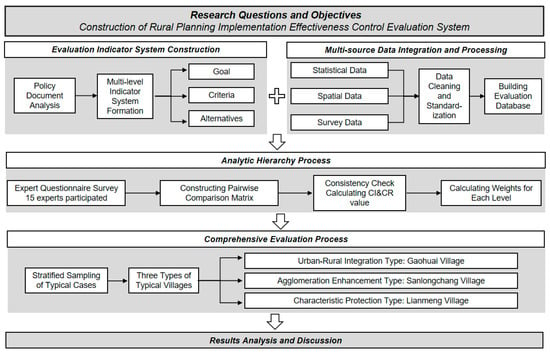
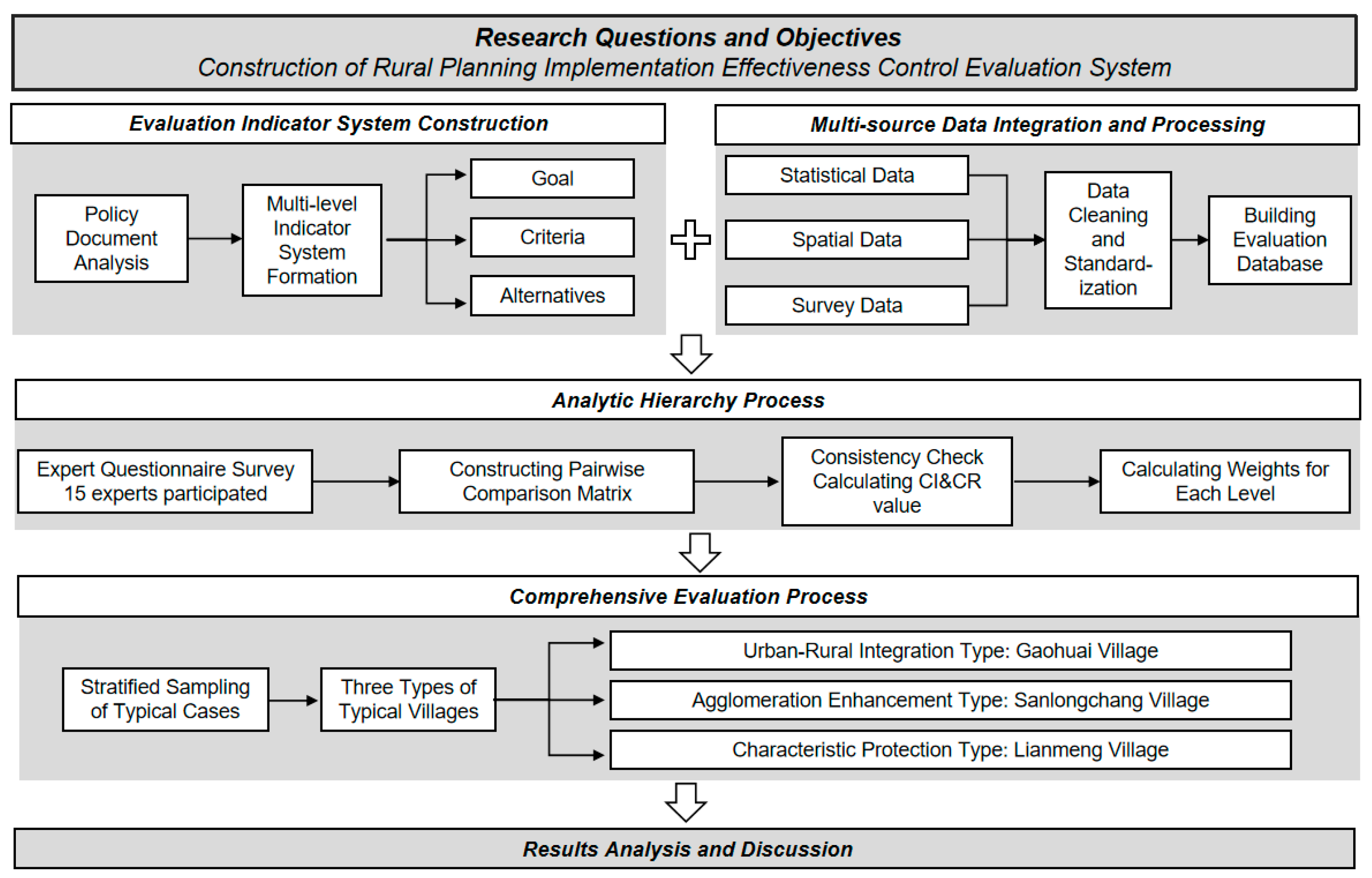
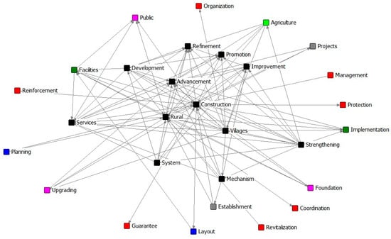
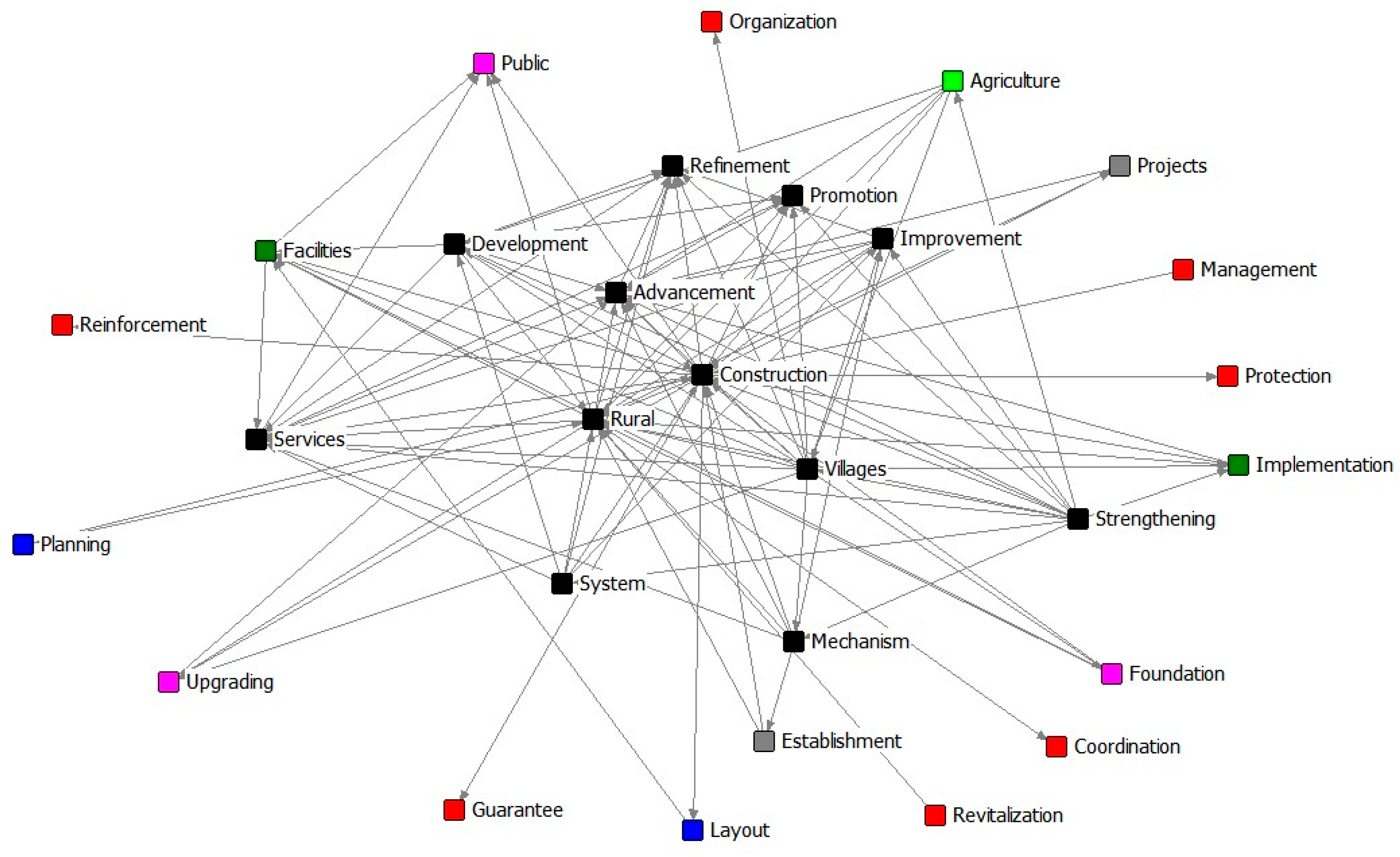
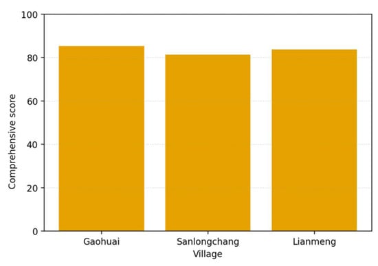
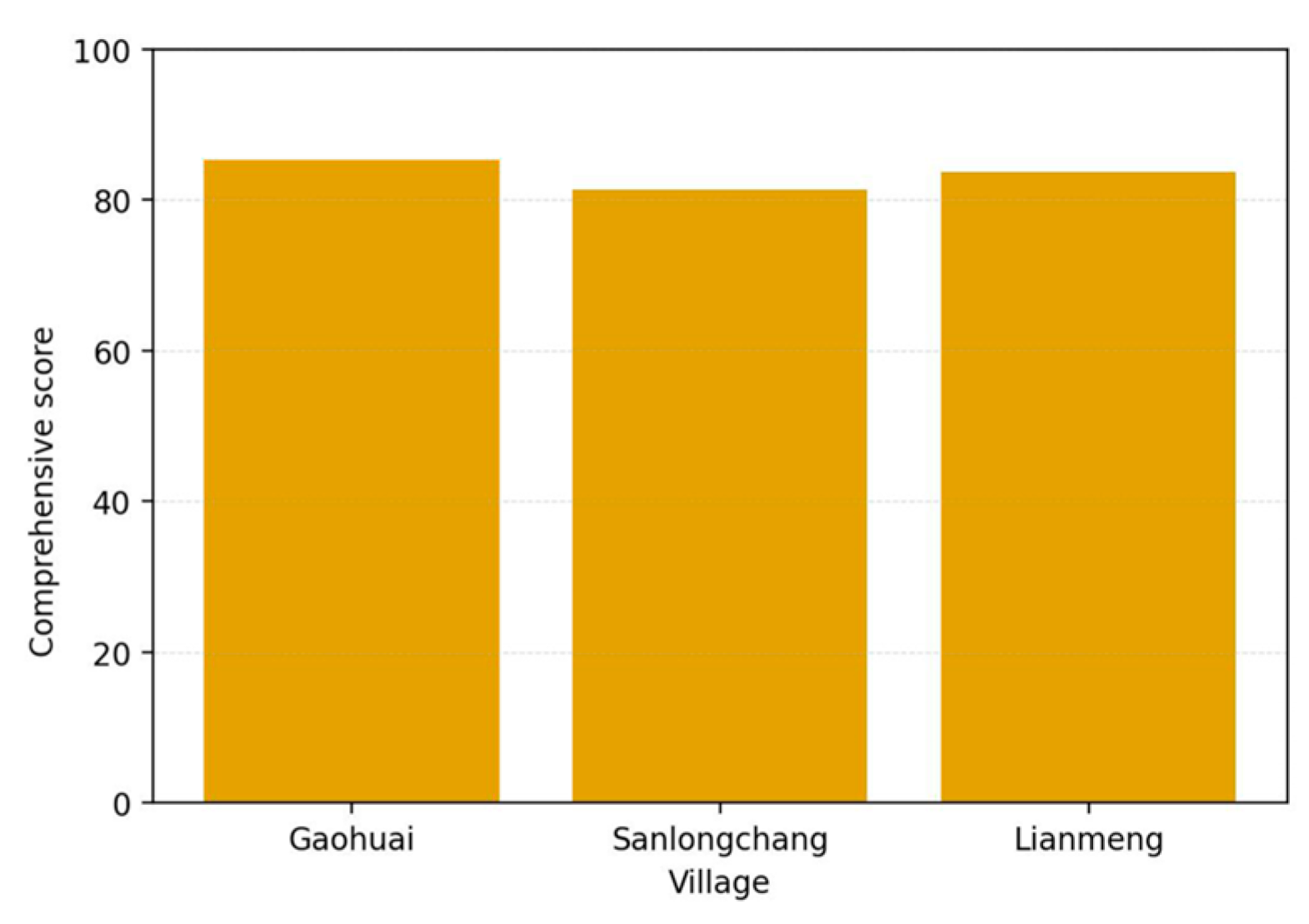
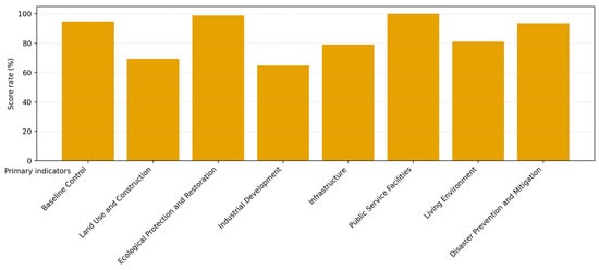
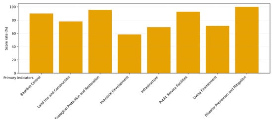
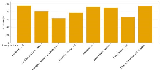
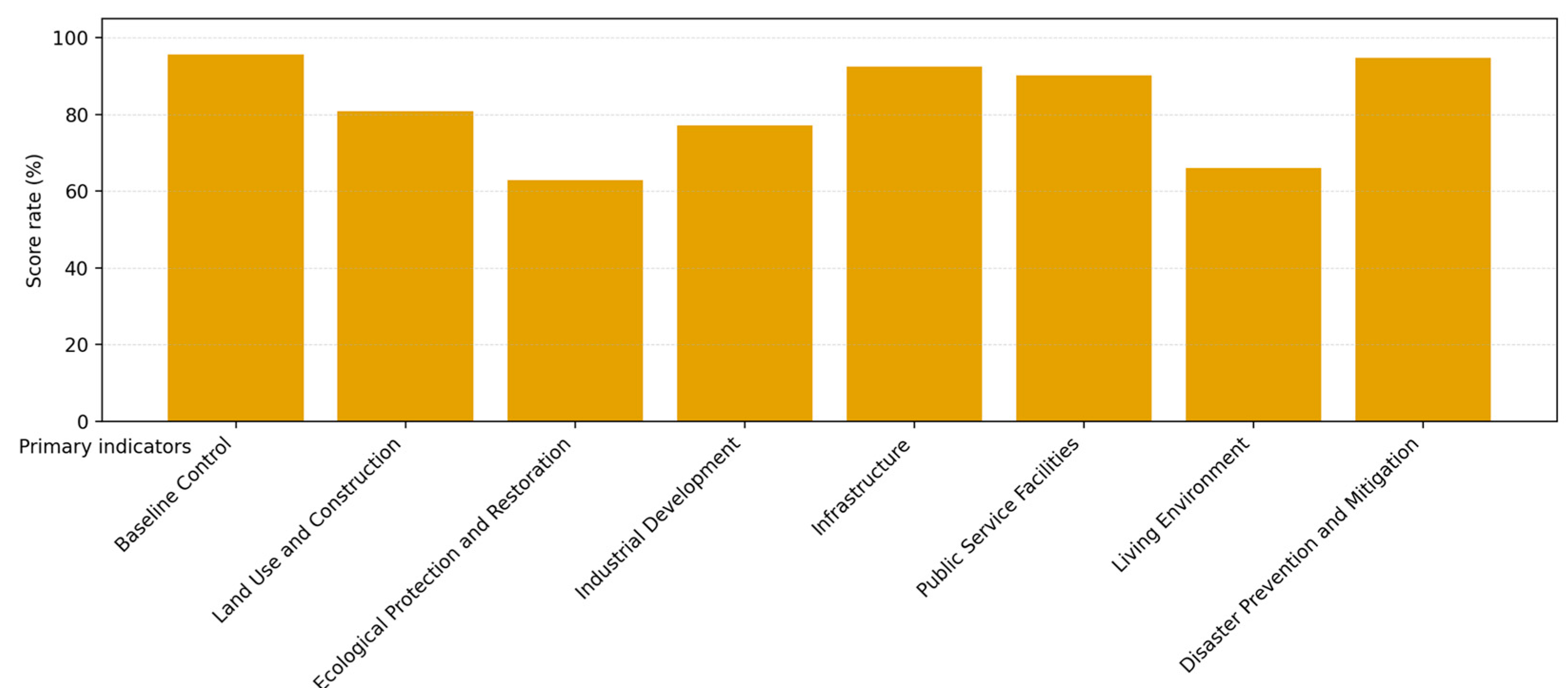
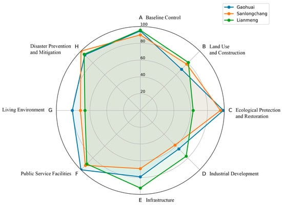
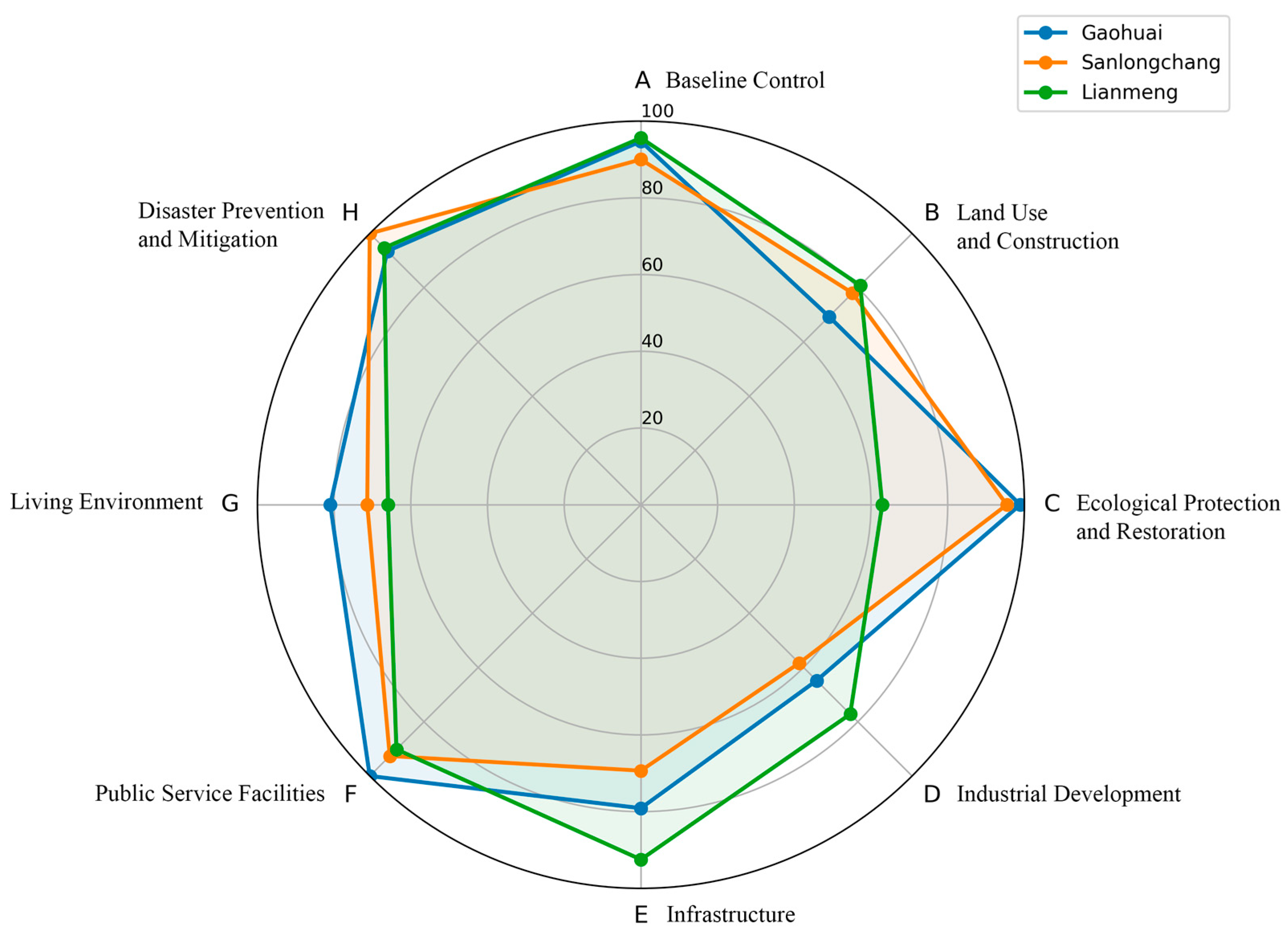
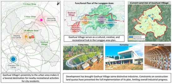
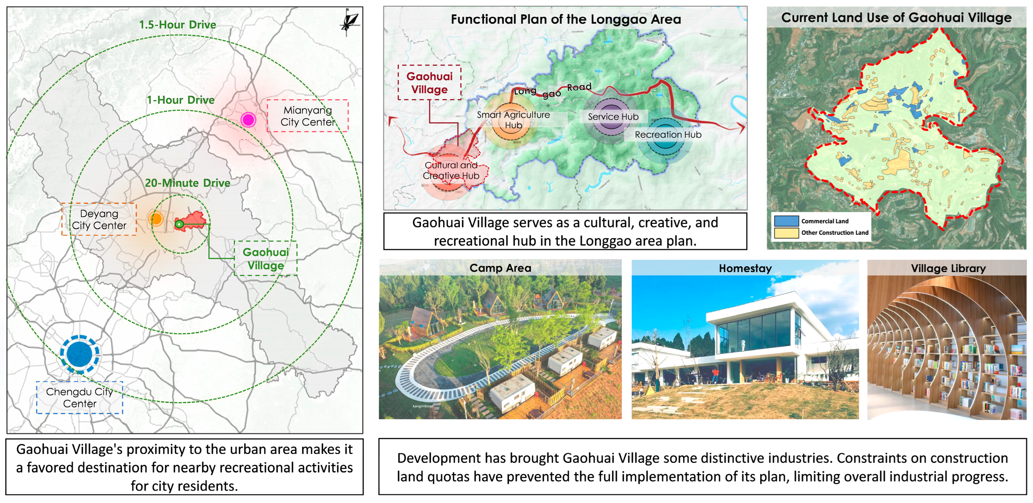
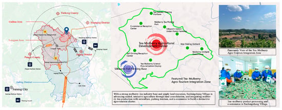
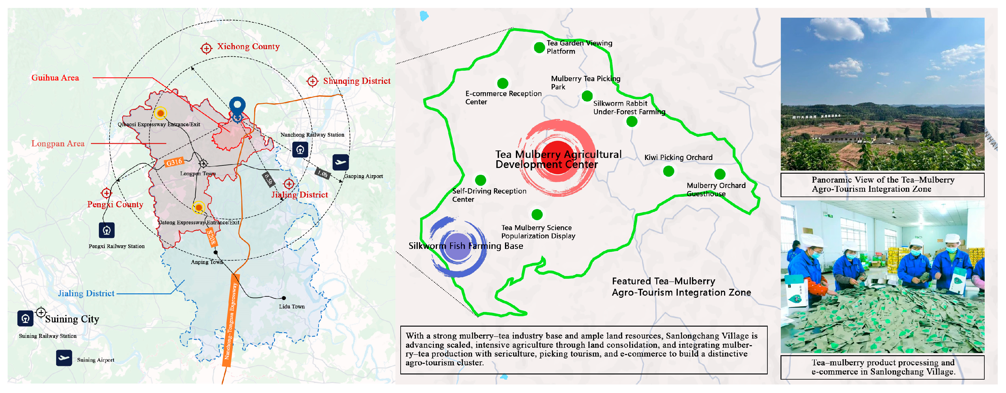
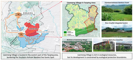
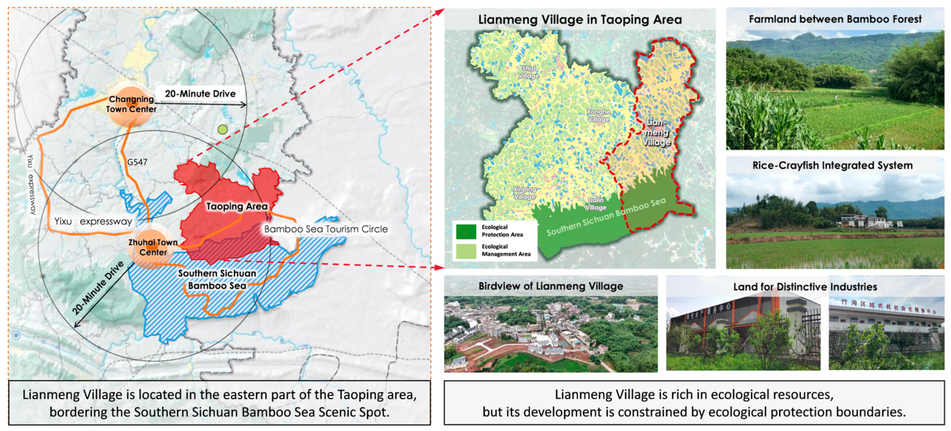






Disclaimer/Publisher’s Note: The statements, opinions and data contained in all publications are solely those of the individual author(s) and contributor(s) and not of MDPI and/or the editor(s). MDPI and/or the editor(s) disclaim responsibility for any injury to people or property resulting from any ideas, methods, instructions or products referred to in the content. |
© 2026 by the authors. Licensee MDPI, Basel, Switzerland. This article is an open access article distributed under the terms and conditions of the Creative Commons Attribution (CC BY) license.