


Abstract
This article discusses the research that formed the scientific and substantive basis for selecting appropriate locations for planting trees in Kraków’s Market Square. This conservation and archaeological protected area has a rich surface architectural heritage and a complex underground stratigraphy, including numerous relics and cultural layers. The article presents the analytical and non-invasive field research methods employed, including the authors’ stage method, which they developed themselves and which allows for the consistent designation and elimination of exclusion zones from the market space. This methodology can support investment of this kind in urban historic zones subject to stringent legal regulations, including those listed as UNESCO World Heritage Sites. The issue raised in the article is relevant due to the increased demand for urban greening in an era of climate change and rising summer temperatures. Such projects affect various areas of the city, often including city squares. This contradicts the basic function of the square, particularly in a historical context. The preservation of historical spaces, such as the one analysed here, is crucial and takes precedence over social initiatives. This is why it is important to pursue sustainable policies for managing historic cities. In this type of project, it is important to recognise that not every urban space is suitable for such undertakings because conservation restrictions can significantly impact the outcome of the project, failing to deliver the expected results. The policy must be aware of the specific historical conditions of such spaces. The authors hope that this case will serve as a starting point for further discussions on the rules of conduct for such projects.
1. Introduction
This article analyses the possibility of planting new trees in the historic market square in Kraków, Poland. This would involve intervening in a protected cultural landscape zone, as the square is included on the UNESCO World Heritage List and in the Municipal Inventory of Monuments and the Register of Monuments. It has also been recognised as a Historic Monument by the President of the Republic of Poland. This type of undertaking also involves earthworks. Given the complex stratigraphic situation of the market square, with underground architectural relics lying close to the surface, the selection of new locations for planting trees is further limited. This analysis was carried out on the basis of the social project entitled ‘Let’s plant trees in the Main Market Square!’ submitted to City Hall and was intended to determine the boundary conditions of the project from the point of view of protecting the Main Market Square in Kraków as a unique cultural heritage site of global significance. This includes protecting the underground historical-cultural structure of the Main Market Square, which forms its architectural and archaeological stratigraphy. The aim is to develop conservation guidelines.
The idea of planting new trees is closely linked to the issue of limited green shade in the historic centre of Kraków and to the goal of mitigating climate change. The project involves modernising the greenery system and supporting technical infrastructure while taking the legal context into account. An analysis and set of guidelines were carried out to ensure that the planned new tree plantings in the Main Market Square would comply with national, EU and international legislation regarding protected areas and would not violate the protected historic substance. These conservation aspects are the main focus of this article.
2. Objective and Methodology
This article aims to demonstrate the crucial importance of sustainable management of the historic fabric of urban centres in the context of climate change adaptation. Using the example of a tree-planting initiative aimed at improving thermal comfort, the article demonstrates that implementing such solutions in historic areas requires a multi-criteria spatial and conservation analysis. The authors note that urban characteristics and stringent legal and conservation restrictions limit the suitability of certain public areas—particularly historic city squares—for traditional forms of anthropogenic green transformation. Consequently, failure to take into account the genius loci and the requirements of conservation doctrines may lead to dissonance and prevent the achievement of the intended ecological and social indicators. This article advocates for the development of a thoughtful, tailored planning policy that complements the requirements of modern environmental engineering with the imperative of cultural heritage preservation. The authors also aim to demonstrate the entire analytical process related to the citizens’ project on the Main Market Square in Kraków, a challenging case study with significant restrictions on activities. The methodology of the research was based on parallel comparative scientific studies, which were applied to the fields of humanities and technology. This strengthened the efficiency and credibility of comparative analysis and contextual interpretation in relation to historical iconographic material, documentation from archaeological research, contemporary technical documentation and the interpretation of bibliographic sources and texts, as well as GPR research, LIDAR and TLS. Contemporary issues related to global warming are driving the integration of green spaces into existing urban environments. This need also applies to—and perhaps even primarily to—historic areas. In light of these challenges, the authors present the problems encountered during the preparatory research for the project, along with their analysis and the solutions implemented. They hope that these experiences will be helpful for future projects of this kind in historic city centres across Europe and around the world.
3. History of Place Transformation
Prior to the foundation of the town, the area of the present-day market square was part of an open settlement that functioned in the early Middle Ages. In 1257, the town was founded under Magdeburg law, resulting in the creation of a main town square measuring 200 × 200 m with streets running perpendicular to it. The exceptions were Grodzka and Floriańska Streets, which were part of the former royal road leading to Wawel Royal Castle. During the Middle Ages, the market square was systematically developed to include administrative and commercial buildings. In the southwestern quarter, a town hall with a tower was built, and a prison was located in its basement. Over the centuries, a granary and a guardhouse were added to the town hall. The town hall building underwent various construction and modernisation projects until the 18th century. In the central part of the square, the main commercial building, the Cloth Hall, was erected in the Middle Ages. It had a strongly elongated rectangular design. This was surrounded by other commercial buildings, some of which were made of brick and known as ‘rich stalls’, as well as wooden stalls, butchers’ shops and other trading sites. In the southern part of the market stood the brick building of the Grand Scales and, in the south-eastern quarter, the Small Scales building. Two churches of a pre-location character also exist in the space in question to this day, which explains their location, which is not related to the later urban layout.
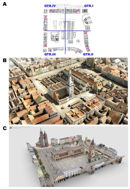
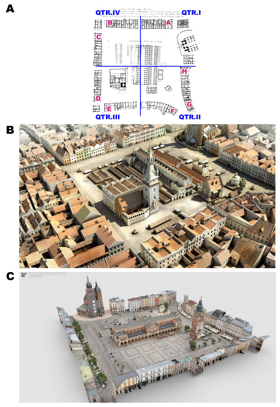
These are the Romanesque St Adalbert’s Church, which now bears traces of the Baroque era, and the Gothic St Mary’s Church, which served as the town parish church in the Middle Ages. Tenement houses that have existed since the Middle Ages line the frontage of the market square and have been transformed alongside the buildings and the size of the plots. Some of these houses have stone perrons that extend well beyond the façades. The dense development of the market square occupied almost 80% of its area until the 19th century, when the city council decided to tidy up the heavily neglected space. As a result, the square’s function was transformed from administrative and commercial to representative. During this reorganisation, some of the commercial buildings covering the market square were demolished, along with the Grand and Small Scales and the town hall building. Only the town hall tower remained, and all the rich and wooden stalls were removed. The main building of the Cloth Hall was restored, preserving its original Renaissance attic, which is decorated with gargoyle sculptures, and its side balcony loggias. The remaining part was re-Gothicised by introducing neo-Gothic arcades in the longitudinal façades. The market space has remained unchanged in this strongly transformed form to the present day, and it was inscribed on the UNESCO World Heritage List in 1978 (Figure 1).
Figure 1.
(A) Dominik Puck’s plan from 1787, the development of the Main Market Square in Kraków, National Museum in Kraków, the red capital letters show the historical markings of the market frontage. These are the lines labelled AB, CD, EF and GH, the division into quarters marked by the authors; (B) 3D reconstruction of the Main Market Square in the half of the 15th century [1]; (C) Kraków Market Square 3D [2].
4. State of Research
Throughout its centuries-long history, the area of the Main Market Square in Kraków has undergone multiple transformations and construction activities, leading to the formation of a rich cultural stratigraphy. Following changes to the organisation of the square, the market underwent numerous works relating to the replacement of the surface, repairs, installations, conservation procedures and archaeological research. The first studies of the Main Market Square were carried out as early as the late 1883 and focused mainly on the Romanesque Church of St Adalbert; these were architectural and inventory surveys [3]. The next studies, which were archaeological in nature, took place during the interwar period [4]. Further work was carried out in the north-eastern part of the square, in the vicinity of St Mary’s Church, during World War II. After the war, in the 1950s, it became necessary to build new technical infrastructure beneath the market square, primarily a sewerage network. During this work, the walls of the Renaissance Town Hall and the levels of stone paving were recorded [5,6]. Work continued from 1955 to 1976 [7,8]. Between 1961 and 1963, and again in 1992, sequences of burials from the church cemetery were uncovered during isolation works at the sacristy of St Adalbert’s Church [9,10], as were further relics within the Cloth Hall [11].
The 21st century was critical in terms of recognising the underground structure of the square. At that time, problems relating to the Market Square surface re-emerged. The heavily damaged and cracked slab allowed rainwater to pass through. At the junction with the Cloth Hall walls, capillary action pulled water up through the building’s foundations, threatening the monument’s condition. A similar situation occurred within the frontage, affecting the technical condition of the pavements. In 2002, work began to modernise the area and replace the existing technical installations. From 2003 to 2004, strict archaeological supervision was carried out in relation to the continuation of these works [12,13,14]. Research works were carried out on the eastern side, including in the area of St Adalbert’s Church, relating to the replacement of the mosaic [15].
The remains of the underground interiors of the Rich Stalls, Grand and Small Scales buildings were also uncovered. Between 2005 and 2010, the final research phase took place on the Main Market Square in Kraków. This was not only related to the modernisation of the pavement, but also to the concept of an underground museum exhibiting architectural relics, cultural layers and a significant quantity of high-quality artefacts uncovered during the excavations [16,17,18,19]. The conservation design of the archaeological and architectural reserve was carried out by the ARCHECON architectural studio, with Andrzej Kadłuczka as the main designer [20,21,22,23]. Unlike all the previously mentioned stages of archaeological research, which were archaeological supervision or limited survey research, this last stage of archaeological research was wide-ranging. For the first time, it was possible to conduct archaeological research on such a large scale. The architectural relics, utility levels and archaeological ‘witnesses’ (untouched preserved cultural layers) that were uncovered during the research were included in the subsequent exhibition. The underground archaeological reserve covered an area of 6000 m2 [24,25].
5. The Current Stage of the Greenery in Kraków’s Market Square
On the Main Market Square in Kraków there are currently 50 trees growing in very difficult soil and spatial conditions with numerous limitations, both above ground and underground. Among the species, the false acacia (Robinia pseudoacacia L.) dominates in different varieties. In addition, different greenery installations are created related to the arrangement of seasonal café gardens in the vicinity of tenement house frontages, made of several forms of low greenery, mainly shrubs, flowers or perennials placed in containers. An extensive network of underground infrastructure serving buildings and events organised on the market square is a limitation in the proper development of trees. An additional complication is the existing objects, surface and heritage of past centuries, which are subject to protection. The analysed trees were subjected to a thorough application in accordance with the applicable European Standard for Tree Assessment using the Basic Tree Assessment method. The team analysed dendrometric parameters for all trees, including crown condition, trunk condition, and rooting conditions. For this purpose, special tree observation cards were prepared, summarising the parameters. After the assessment, the results were presented in summaries and maps based on the individual case reports [26]. Nearly half of the trees are in medium or poor condition, which indicates that the existing possibilities of growing trees on the market, especially in the era of difficult climatic conditions, especially drought and heat, are slowly running out, and solutions need to be found to improve the living conditions of trees, especially within the root systems.
6. Identification and Analysis of the Underground Architectural and Archaeological Structure Within the Frontage and Main Market Square in Kraków
The research and analysis were divided into several stages. First, an analysis of the existing architectural relics under the surface of the Market Square, which constituted the first exclusion zone, was carried out. Then, the occurrence of objects not discovered during field research but known from archival documentation, written sources and iconographic sources was taken into account. These objects, together with intact archaeological layers, constituted another exclusion zone. Further analysis concerned the existing underground technical infrastructure. The penultimate stage involved preserving protected views and the cultural landscape, which included the inscription on the UNESCO World Heritage List.
Ideally, a summary of all exclusion zones would provide information on suitable locations for tree planting. However, the list of restrictions became increasingly long, resulting in the gradual elimination of such areas as the research progressed. In the final pre-design phase, the areas selected for tree planting were subjected to non-invasive tests using GPR, supported by LIDAR and TLS. This was the final stage of the research, and the results had to be submitted to the Heritage Conservation Authority for approval together with the design concept.
As part of the research, the market space was conventionally divided into four quarters: I north-east, II south-east, III south-west and IV north-west. To analyse the archaeological situation within the frontage of the market square, the following nomenclature was used: Line A–B: northern frontage; Line C–D: western frontage; Line E–F: southern frontage; Line G–H: eastern frontage.
6.1. Identified Underground Structures
6.1.1. Underground Market Square Archaeological Reserve
The Underground Market Square is an archaeological and architectural exhibition space created through the exploration and excavation of fragments of the Rich Stalls and the Grand Scales, as well as the opening of the cellars in the northern part of the Cloth Hall. Designed and implemented between 2006 and 2010, it was co-financed by the European Regional Development Fund. Over 140 burials have been documented throughout the entire area occupied by the reserve. The necropolis was in use in the 11th century, and the number of skeletons suggests that it was an extensive cemetery that extended beyond the current boundaries of the Market Square, where the deceased inhabitants of the original location of Kraków were buried [16]. The entire area of the reserve is covered by a reinforced concrete slab ceiling, which is why introducing greenery to the surface above it was not an option. Similar restrictions apply to the proposed protective buffer zone established along the vertical load-bearing walls of the reserve to enable conservation and emergency work on this structure, if necessary.
6.1.2. The Small Scales
The Small Scales is one of two weigh houses in the Main Market Square in Krakow, located on the eastern side of the Rich Stalls. In the eighteenth century, the building was in poor condition and, despite renovation attempts, was demolished in 1801. When designating the archaeological protection area in quarter “qtr–II” (south-east), it was necessary to recognise the precise location of the Small Scales building relics under the Main Market Square and to qualify this area as strictly protected. Additionally, a 3-metre-wide protective buffer zone was established around the outline of the building’s floor plan to safeguard the stratigraphy of this area and the context of the building.
6.1.3. Town Hall
The town hall may have been built in the last quarter of the 13th century. Wiktor Zin and Władysław Grabski identified the remains of the eastern section of the town hall cellars under this building. These cellars ran parallel to the cloth merchants’ stalls and were destroyed when the German occupiers built a reinforced concrete fire reservoir on this site in 1944. The earliest written reference to the stone building dates to 1316 (in the oldest surviving court and municipal records of Kraków, in which the word ‘rathus’ appears), while the first mention of the town hall tower dates to 1383 [27]. The building was single-bay on a rectangular plan, measuring 30 by 10 m, with an adjacent town hall tower to the southeast [27,28].
The rows of walls uncovered during archaeological research lie just below the surface of the square. Due to the walls’ shallow foundations, which are the remains of demolished town hall buildings and adjoining areas, it is not advisable to plant greenery in this area, except in places previously occupied by trees. The current location of the trees near the town hall tower resulted from a project to modernise the pavement and add greenery, which was carried out immediately after the archaeological research and at the exposed crowns of the walls. This enabled the relics to be bypassed when planting trees, which is why they are not in a perfect line.
On the north side of the tower, above the relics, there are two reinforced concrete slabs. One slab is a load-bearing element that protects the relics from loads and pressures. The other slab covers the post-German reservoir. For this reason, it is not possible to introduce rooted greenery in this area.
6.1.4. The Cemeteries Around the Mariacki and St Adalbert Churches
The cemetery at the Mariacki Church dates back to the construction of the Romanesque basilica around 1222. It had an independent cemetery chapel dedicated to St Barbara which was demolished a few years later and rebuilt as a church between 1394 and 1399. The area around the Church of the Blessed Virgin Mary, which was occupied by a cemetery, is documented on Kołłątaj’s Map of Kraków (late 18th century) and Dominik Puck’s Map of the Market Square in Krakow (second half of the 17th century). The cemetery was surrounded by a high wall with four or five gates, with the main gate located directly opposite the church entrance. For health reasons, the cemetery was closed in 1796 [29]. Another exclusion zone has been established here.
Archaeological research at St Adalbert’s Church has gradually led to the discovery of several churches that once stood here. The oldest, a wooden structure, dates to 990–999; the youngest, a single-nave structure made of limestone blocks whose masonry bonds and details are still visible today, dates to 1079–1100 [9]. Until the end of the fifteenth century, there was a small cemetery around the church of St Adalbert, which was liquidated at the beginning of the sixteenth century during the great Renaissance levelling of the Market Square.
The current surroundings of the church are marked with a different type of modern surface to indicate the extent of the church cemetery. This area was not recognised as a total exclusion zone due to the possibility of planting in places where archaeological digs have taken place and the cultural stratigraphy has been removed.
6.1.5. Wooden Stalls at the Western Wall of the Cloth Hall
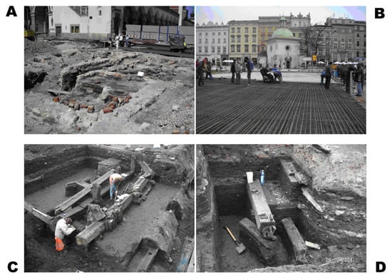
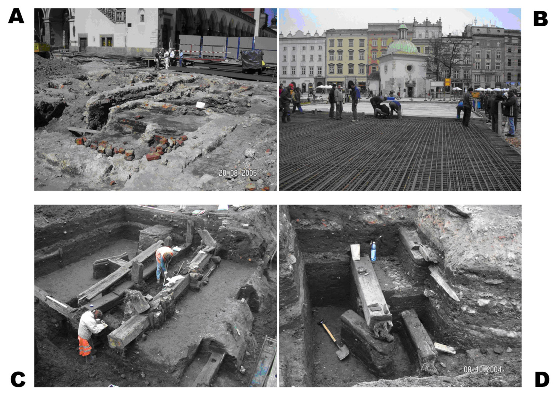
Archaeological and architectural research was conducted in this area in 2004, resulting in the discovery of wooden structures and ground floor walls, as well as the remains of a paved surface between them. The Archaeological Museum in Kraków conducted the archaeological research, with the participation of staff from the Faculty of Architecture at the Krakow University of Technology [12,13,14]. The relics were inventoried and protected with a layer of soil before new hardening layers were laid for the Market Square pavement. This area is not suitable for planting (Figure 2).
Figure 2.
(A) The exposed crown of the walls of the Grand Scales, archaeological research 2005; (B) Installation of the ceiling structures of the “Underground Market” reserve above the Grand Scales relic, 2010; (C,D) Archaeological research on the western side of the Market Square 2004–2005 and the discovery of relics of wooden stalls in the area between Badylak’s well and the northern part of the Cloth Hall, all photos by A. Kadłuczka.
6.1.6. Mediaeval Perrons
The perron was a structure added to the front façade of the tenement house at ground floor level. As a result of the continuous cleaning and levelling work carried out on the rapidly rising Market Square, the perron sank, making direct external communication difficult [30,31]. Andrzej Kadłuczka carried out a detailed study of Krakow’s perrons [32,33,34]. As part of this study, the condition of the perrons in the tenement houses surrounding the market square was assessed, revealing that they have been preserved in 75% of buildings. It was also found that, on average, the usable level of the perrons is 470–530 cm below the current level of the Main Market Square pavement, and that most of them are vaulted with arches running parallel to the frontage regulation line.
Considering their current state of preservation, they form a single, compact, authentic archaeological relic with great scientific and research potential, which does not preclude their future musealisation. Therefore, in terms of planting, it is proposed that a buffer zone be created in front of the market square houses.
6.2. Objects Known from Historical Sources—Not Identified in Field Research
Butcher’s shops and wooden stalls were still in existence in the fourth quarter of the 18th century. They were catalogued by Dominik Puck (Figure 1A) and depicted fragmentarily in iconographic sources. These sources provide fairly accurate reproductions of the wooden structures and architectural details in the north-western corner of the Market Square between 1850 and 1859. This area belongs to quarter IV. With the exception of the wooden stall structures located near the western wall of the Cloth Hall, which were identified in field research, the area has not been investigated archaeologically. Replacing the pavement involved digging down to a depth of 1.2 m—the thickness of the modern technical, insulating and structural layers of the current pavement, which must meet modern standards relating to resistance to the pressure of fire engines and other heavy equipment. Below this level, intact cultural layers are present. Due to their critical and archaeologically sensitive nature, almost the entire area has been designated a protected zone. The boundaries extend to the point where the wooden stalls reportedly ended, according to available historical sources. Only a narrow strip, which is potentially free of historical structures, has been left for further consideration.
7. Research Results with a Proposal of Places and Number of Trees to Be Planted
Due to numerous construction interventions in the past, the cultural layers above the mediaeval period have practically been removed in many places around the Main Market Square. Recent studies (2004–2010) have recorded fragmentary Renaissance layers, for example, near the Town Hall building and during the uncovering of a Renaissance cellar on the north-western side of the square. In many places, only late mediaeval layers were uncovered during the research, as these cultural layers lie practically under the contemporary pavement. In 2005, fragments of 19th-century cobblestones were discovered near the Grand Scales. These had survived the replacement of the pavement in the 1960s, when most of the cobblestones were demolished. Documentation from recent studies clearly indicates that the crowns of underground building walls, reshaped by demolition work, lie very shallowly. The stone and brick structures uncovered during the 2005–2010 research were mostly incorporated into the underground museum exhibition. For understandable reasons, including the construction technique used for the ceiling above the museum space (reinforced concrete slab), the area above the museum is not suitable for planting trees and lies within the exclusion zone.
Outside the museum are the Town Hall, the Small Scales buildings and some of the rich stalls. The remains of the wooden stalls, including those on the west side of the Cloth Hall, constitute another exclusion zone. Following the recent modernisation of the Market Square, the construction and technical layers are approximately 1.2 m thick and have no historical value, as mentioned above. Based on the collected materials, including archival research on the archaeological and architectural stratigraphy of the Main Market Square, the layout of the underground technical infrastructure, and the analysis of the architectural, historical and visual exposure values of the tenement houses, the most suitable areas for implementing the project have been proposed. These areas are located in quarters II, III and IV. A two-stage scale was used to assess the safety of the proposed locations for hidden heritage:
- The green colour marked on the map indicates areas that are safe for tree planting and recommended in terms of archaeological heritage protection;
- The yellow colour indicates a zone that is permitted under certain conditions.
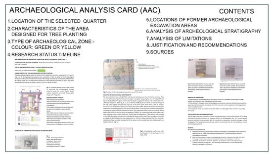
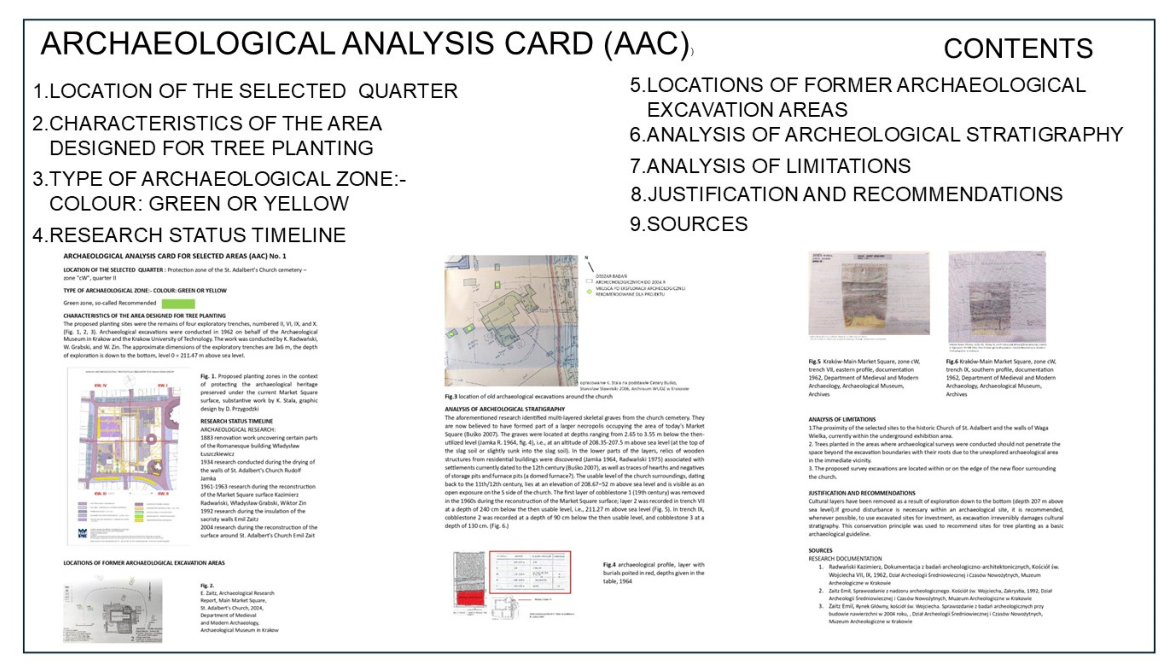
A developed Archaeological Analysis Card has been created for each of the proposed areas (AAC) (Figure 3).
Figure 3.
An example of an Archaeological Analysis Card for Quarter IV of the St Adalbert Church site. The content and graphic design are by K. Stala.
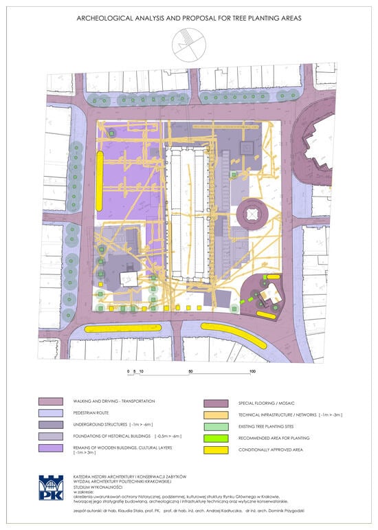
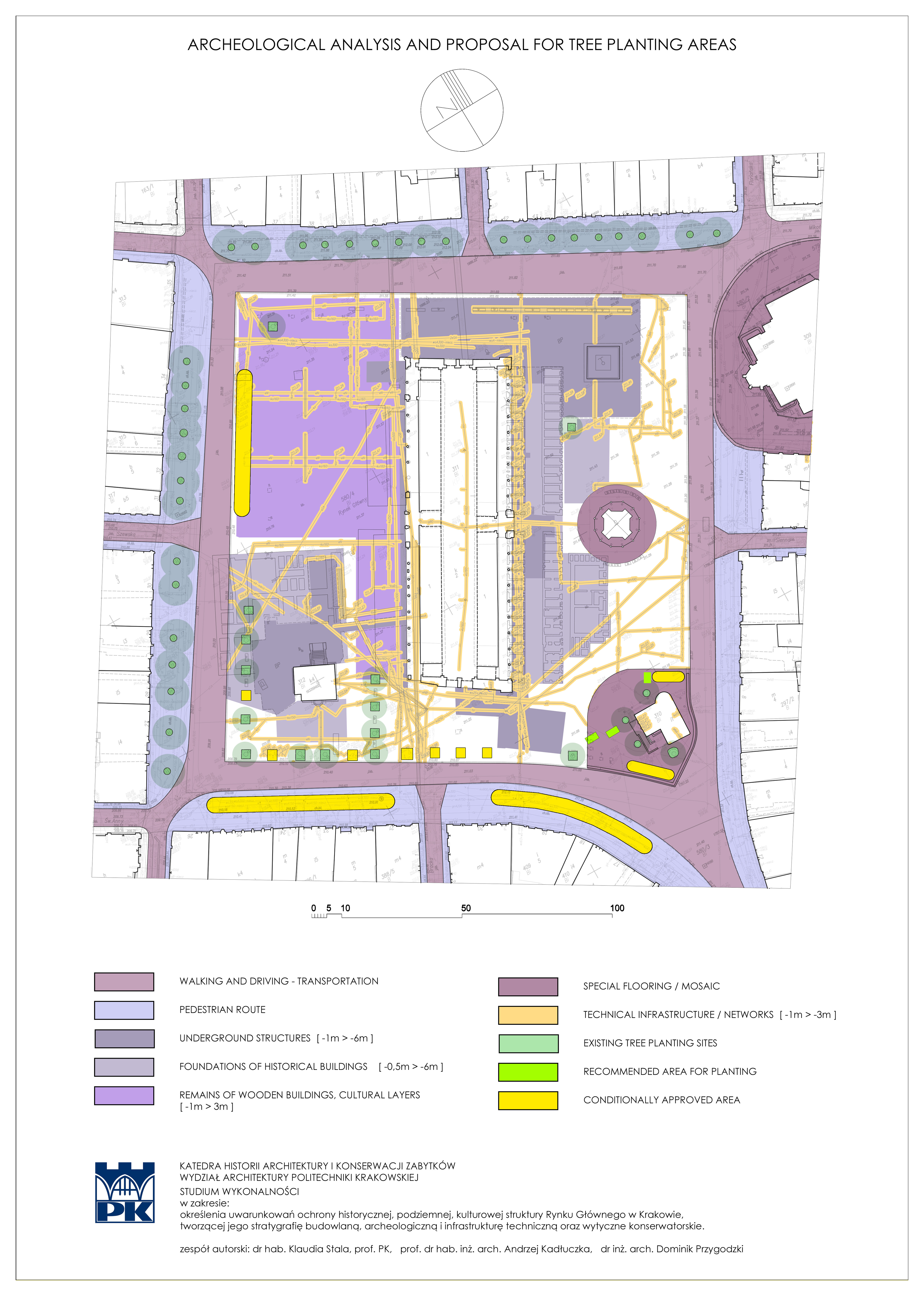
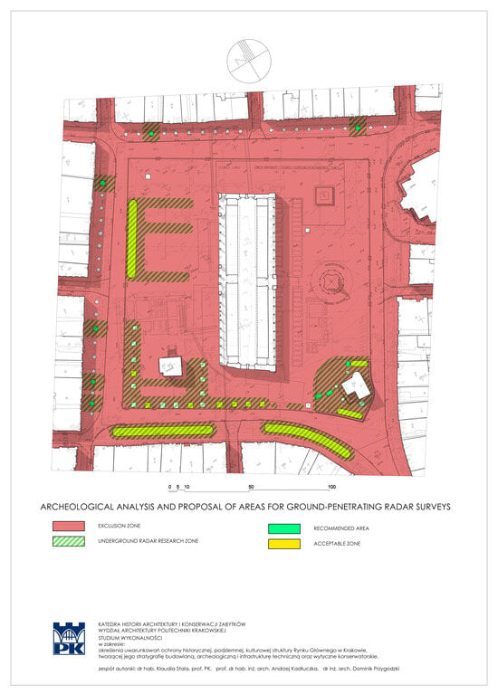
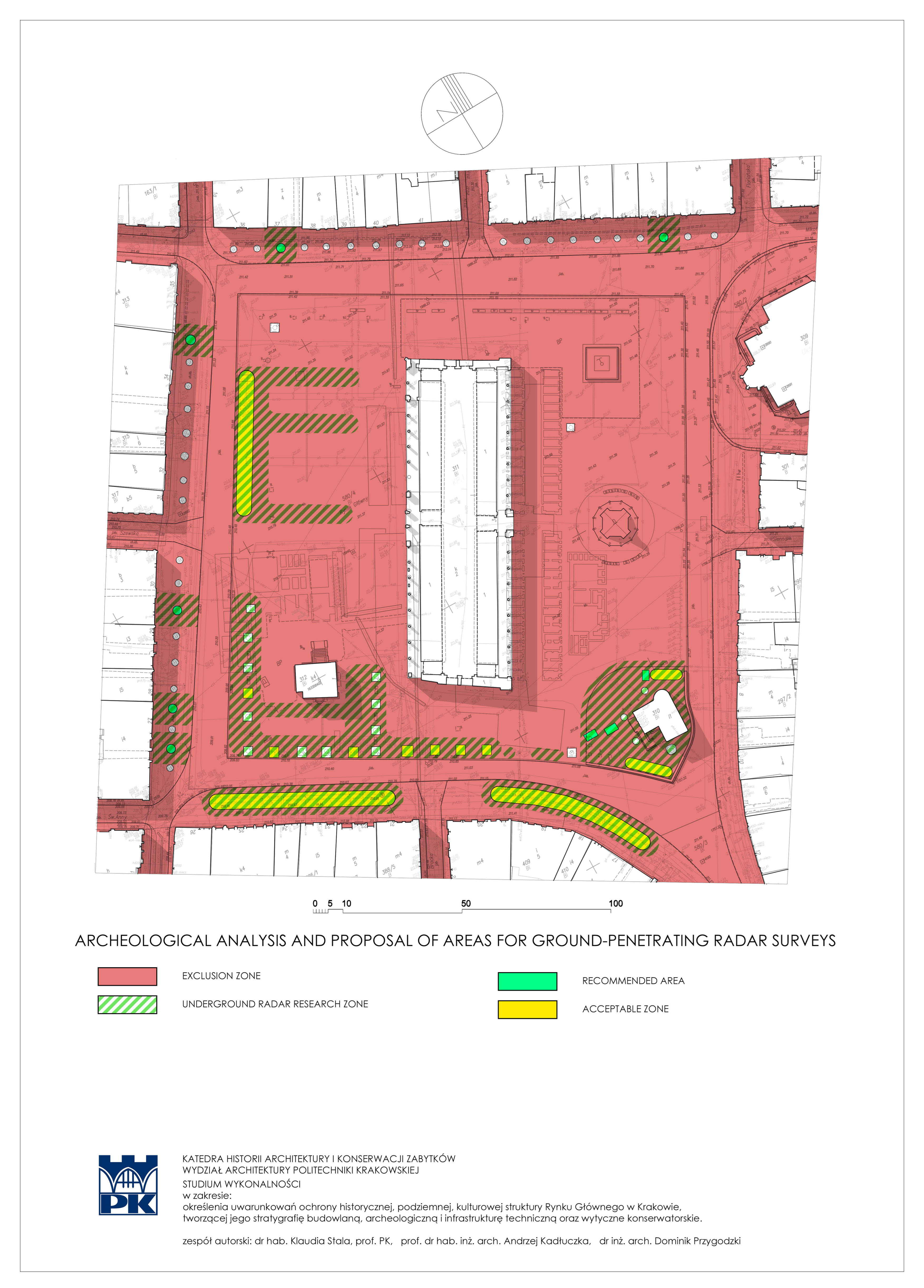
The proposed planting areas were marked on the board, along with the indicated archaeological exclusion zones (Figure 4):
Figure 4.
Map of the Krakow Market Square showing the proposed areas for planting trees and exclusion zones, legend below, at the bottom of the page information about the affiliation of the authors conducting the research: Department of History of Architecture and Monument Preservation, Faculty of Architecture, substantive work by A. Kadłuczka, K.Stala, D. Przygodzki, graphic design by D. Przygodzki.
- The area marked in purple is unexplored and has preserved cultural stratigraphy.
- Dark grey marks show the existing and functioning underground museum zone.
- Light grey indicates underground architectural relics located outside the exhibition area of the reserve and the foundations of underground buildings.
- Orange indicates the course of technical infrastructure.
- White with a thick black line around the perimeter indicates objects standing on square paving.
Only four new sites were marked in green; all of these were located in the cemetery area next to St Adalbert’s Church. These were former archaeological test pits in which cultural layers up to the depth of the natural subsoil had been explored, with no relics of immovable monuments found. Unfortunately, the surveys left a few too-small former test pit zones, each measuring approximately 3 × 6 m. These would only allow for the planting of individual deeply rooted trees, as exploration in these places reached a depth of 2.65 to 3.55 m below the current usable level, i.e., 211.47 m above sea level. The basic conservation principle was applied here: when it is necessary to interfere with the ground at an archaeological site, it is recommended to use areas that have been examined by excavation for investment purposes, since excavation work irreversibly destroys cultural stratigraphy.
The remaining explored areas were unsuitable for the project. This was because they were located within the reserve, contained architectural relics lying close to the surface or had to be excluded to preserve the view of the most important historic buildings in the market square. Therefore, the focus shifted to areas classified as conditionally acceptable and marked in yellow on the map and in the Archaeological Analysis Cards. These were areas that had not been archaeologically surveyed; however, based on available historical sources, they were not expected to contain any relics of underground architecture. The primary restriction applied to these sites was therefore to limit the planting depth to 1.2 m from the square paving, i.e., the depth at which the layers were disturbed during the modernisation of the pavement. To limit the spread of roots, two appropriate planting systems were proposed alongside tree species corresponding to the existing Market Square greenery. These species were resistant to contemporary environmental and climatic conditions and could grow with shallow roots. The planting systems are based on the construction of underground planters in two different variants. The first variant involves constructing a prefabricated reinforced concrete planter with significantly larger dimensions than existing ones: 2.5 × 5 × 1.2 m [35]. This solution was tested in terms of design and implementation in Polish conditions during the reconstruction of the Market Square in Nieszawa. The purpose of this system is to provide a safe environment for the trees to take root while restricting their growth by creating pot walls. The second option uses modern anti-compression modules to create load-bearing layers between the reinforced concrete bottom slab, protecting the historical layers of anthropogenic origin [34]. This second solution is permanent and not as easily reversible as the first option. The yellow areas consisted of narrow, long strips of land, which allowed a larger number of trees to be planted in a single row. Three such areas were selected in Quarter II: two within the cemetery next to St Adalbert’s Church, and one along the southern boundary on Line E–F. Similarly, in Quarter III, a narrow strip was selected on the southern frontage on the same line. The locations selected within the southern frontage had to be far enough away from the former perrons’ underground structures—this was one of the buffer zones we had designated, which is why the greenery areas were located quite close to the transport route. The last location was proposed in quarter IV, in the north-western part of the market square, outside the area recognised as a potential place for the occurrence of wooden stalls. We obtained data on the location of these wooden structures from iconography and the aforementioned plan of Puck, as well as from 19th-century Austrian military documentation (the south-eastern part of Poland was under Austrian partition at that time), which is likely to be accurate. The location was also important from a composition point of view, as it was situated on the axis of a row of trees that were planted during archaeological research when the tops of the walls of the former town hall were still visible. Despite the strength of the historical data, screening georadar surveys were conducted on all selected sites marked in yellow. This was the final stage, but it could still generate changes to the design and reduce the number of selected sites (Figure 5).
Figure 5.
Map of the Krakow Market Square showing the proposed area for a non-invasive geophysical survey using GPR, LIDAR and TLS. Legend below, at the bottom of the page information about the affiliation of the authors conducting the research: Department of History of Architecture and Monument Preservation, Faculty of Architecture, Substantive development by A. Kadłuczka, K. Stala, D. Przygodzki, graphic design by D. Przygodzki.
8. GPR Research and Preparation of Final Test Results in Order to Provide Design Guidelines
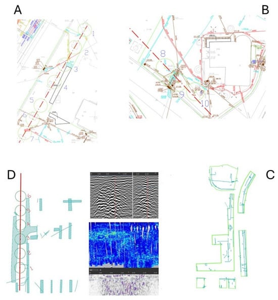
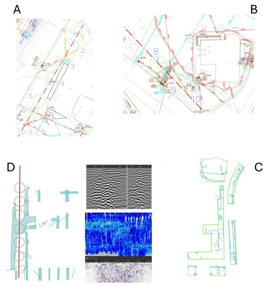
In accordance with the above recommendation, non-invasive prospecting was carried out in selected locations conditionally approved for planting at the end of November 2024. This involved the use of ground-penetrating radar and detectors installed in sewer manholes. An inventory of the indicated market areas was also made using laser scanning. From the perspective of protecting archaeological heritage, it was important to rule out potential conflicts between the project and relics not included in sources or earlier studies. Once the data had been collected, the team interpreted it in terms of anomalies occurring in critical locations and formulated additional recommendations (Figure 5). For non-invasive surveys, the IDS Stream DP ground-penetrating radar was used to create three-dimensional maps of underground objects and urban utilities. The Stream DP’s EsT (Equalised Scrambled Technology) is capable of utilising the full power of the electromagnetic wave emitted by the radar and ensures proper detection of both lower and higher. The second ground-penetrating radar used was the Leica DS 2000, equipped with a dual-frequency antenna (250–700 MHz—depth from 0 to 4 m), which detects objects located at greater depths (250 MHz antenna) as well as objects located shallowly beneath the ground surface (700 MHz antenna). In addition, it is possible to trace the distribution of geological formations with different electrical properties. The following equipment was also used: RD8000 and RD8100 detectors, a SIRIUS GNSS receiver, a Leica BLK 360 laser scanner, and a Geomax ZOOM95 3” total station. The ground was not damp during the survey. GPR work was carried out in accordance with BS-PASS-128.
8.1. The Western Row of Trees by the Town Hall Tower
In this area, plans are in place for additions to existing plantings and the replacement of diseased specimens. No extensive ground disturbance is anticipated. When replacing trees, it is recommended that they be planted in the same locations. Archaeological supervision is also recommended for all earthworks in this area. GPR survey results confirmed that the existing tree row is located in close proximity to the underground remains of the former town hall. The roots of trees No. 3 and 4 are particularly close to these remains (Figure 6A).
Figure 6.
Non-invasive survey: (A) research results in the vicinity of the Town Hall Tower (south-western part), Quarter III; (B) research results in the vicinity of St Adalbert’s Church (south-eastern part), Quarter II; (C) research results on the southern frontage of the Market Square, the Perrons Zone (line E–F), Quarters II and III; (D) research results in Quarter IV. Graphical presentation of the presence of relics in relation to the concept of tree location in this place. Clusters of irregular GPR signals presented in vertical sections. Potential rubble or remains of foundations. Tree No. 3 in the middle circle and a visible accumulation of signal interference [36].
8.2. The Area Around St Adalbert’s Church and Its Former Cemetery
Research has shown that, with the exception of tree no. 8, there were no anomalies that could be interpreted as relics of former buildings. The area where tree no. 8 is to be planted is located near two unidentified georadar anomalies facing the planned location. However, it should be noted that the georadar signal breaks off slightly earlier, and the readings did not rule out planting trees in the planned location. When planting trees, it is necessary to ensure constant archaeological supervision (Figure 6B).
8.3. Southern Frontage of the Market Square, Perrons Area, Line E–F P3 Quarter II
The tree line in this area needed to be moved to a safe distance from the zone designated in this study in order to protect the perrons. The size of the buffer zone meant that planting could only be done at the junction of the pedestrian and transport routes. Georadar surveys revealed a significant number of linear anomalies and small subsurface objects in these areas that were not marked on the technical infrastructure map. These are most likely remnants of old networks, buildings and foundations. Some of these networks are still active and cannot be detected by any method other than ground-penetrating radar. Therefore, the plan to plant trees in this area was abandoned (Figure 6C).
8.4. Northwestern Part of the Market Square, Quarter IV
An area has been designated for planting a row of trees in a location practically on the border between the square and the transport route. These trees will be aligned with the existing row running parallel to the northern wall of the town hall tower. According to the analysis carried out, the aforementioned quarter should contain the remains of wooden stalls which have not yet been examined by archaeologists but which are documented in written and iconographic sources, as well as in Austrian historic geodetic documentation. To avoid the area of the presumed wooden buildings, the potential planting site was selected based on the aforementioned data, outside the range of the buildings.
The GPR surveys were carried out over the entire area of the quarter. The research revealed numerous anomalies across the entire study area, forming regular, longitudinal lines running parallel to the western wall of the Cloth Hall. Such georadar readings may indicate the remains of foundations or rubble resulting from the demolition of buildings. The pattern visible in the readings unambiguously indicates the remains of the aforementioned stalls, confirming the reliability of historical sources. Verification of the readings with existing sources shows minor but significant, from the point of view of the project, differences in the extent of the relics’ location compared to the existing documentation. According to the readings obtained, the planned tree-lined avenue is located between two parallel lines of signals, which may be the remains of wooden stalls that should not be located in this place. The changes occur at a depth of approx. 2 m from the current usable level of the square paving. In the locations of the proposed tree plantings nos. 1, 2, 4, 5, and 6, the signal is negligible, and the readings show continuity of the soil structure, which means that there are no relic remains in the soil in these specific locations. However, the biggest problem arose with the location proposed for planting tree no. 3. The tree collided with anomalies that begin to be visible at a depth of 1 m from the current usable level. This is the limit depth at which the modern technological layers under the market square surface end. The data from the GPR reading at this location are as follows:
Spatial Resolution: Vertical (radial) Resolution: Estimated using the Rayleigh criterion for a wavelength of 20 cm in the given medium, which yields approximately 5 cm. This confirms our capability to clearly distinguish the top of the horizontal anomaly. Horizontal (lateral) resolution: Determined by the inline triggering interval (5 cm) and the first Fresnel zone radius at a depth of 1.0 m (approx. 25–30 cm), ensuring spatial continuity for the interpreted 7 m-wide structure.
Exact Penetration Depth: The total time window of the radargram (50 ns) combined with the calculated wave velocity yields an exact maximum penetration depth of 3.5–4 m. Consequently, the 7 m-wide horizontal structural change can be accurately localised in the subsurface zone at a depth 1.0 m. The GPR reading indicates the presence of visible, dense reinforcement securing the pavement’s deck. Less dense sections with additional signal attenuation were recorded at greater depths. The irregular shape could be the remains of cobblestones or demolition debris, or a modern-day layer of rubble added to level the ground beneath the technological layers on the surface.
Nevertheless, it is necessary to conduct an archaeological survey prior to the implementation of the project in order to verify whether the site is a historical object. We have made our decision to plant this tree in this location dependent on the results of this survey. The other trees, with a depth of no more than 1.2 m, should not pose a threat to the relics located at a depth of 2 m, but another condition was the use of special boxes in which the trees will be placed and only then planted in the ground. Such boxes will prevent the roots from spreading sideways and deep into the ground, which will protect the relics below. If archaeological research needs to be carried out in this area, they can be temporarily removed without damaging, so the planting would not be permanent and could be reversible, which is recommended in contemporary design policy within archaeological sites (Figure 6D).
9. Opinion of the Heritage Conservation Authority
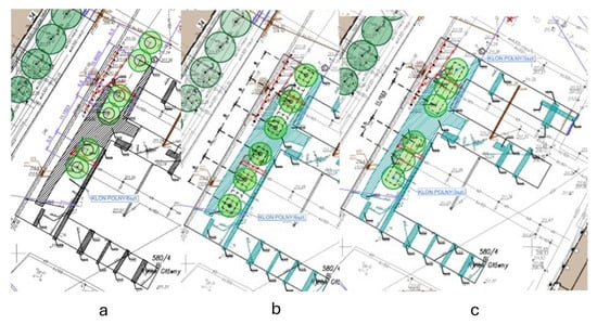
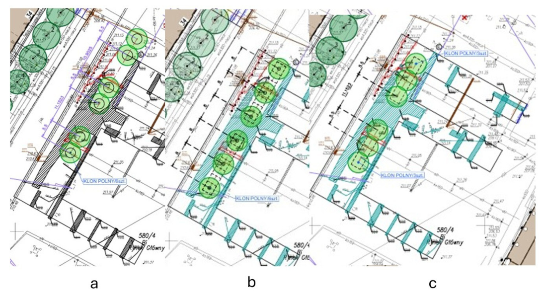
Despite the collision with underground structures in quarter IV of the market, which was identified on the basis of GPR surveys, the research team decided to leave the proposed plantings in the form of a single row of trees in this location, considering these plantings to be safe for the underground heritage while maintaining our conservation conditions described above. To that end, a series of additional scenarios were developed to safely bypass the anomaly detected by the ground-penetrating radar. The authors present three of these scenarios. In the original version (Figure 6D), the plan was to plant a row of six trees spaced 8 m apart. However, avoiding the underground anomaly required a redesign while preserving the views. Figure 7a involved arranging the six trees in pairs, with each pair spaced 11 m apart. This allowed the anomaly, which was identified as having a range of approximately seven metres, to be bypassed at a distance of 1.5 m from both its edge. In this version, the pair of trees on the north side obstructed the view of the Sukiennice, so this option was not feasible. Figure 7b involved planting six trees at equal intervals to leave a distance slightly larger than 8 m. In this version, the buffer zone on either side of the anomaly was insufficient. In this scenario, the view protected by the UNESCO zone from the southern side of the tree row would also be obstructed. Figure 7c required a smaller spacing between the trees, with a 11-metre gap within the anomaly zone. In terms of composition, the version with a large gap in the centre of the row of trees was not satisfactory (Figure 7). It was therefore decided to submit a proposal to the preservation authorities to reduce the number of trees to four, spaced 11 m apart. This was despite the fact that, visually, it did not blend in well with the existing row of seven trees along the Town Hall walls, as the new tree-lined avenue was intended to duplicate what had been implemented in the southwest part of the market square. However, this version did not threaten any protected views. Next, an archaeological survey was recommended to determine the nature of the anomaly.
Figure 7.
Version of the tree scenarios prepared by the Team for Historical and Contemporary Conditions Related to Green Spaces, Team for Compositional and View-Related Conditions, and Team for Architectural and Archaeological Conditions, including the authors of this publication. Scenario (a) an arrangement of six trees in pairs; scenario (b) arrangement of six trees at equal intervals; scenario (c) six trees in a three-by-three arrangement.
It was decided that the remaining depths (2 m from the surface) were suitable for safe planting using the previously discussed technique of planting in boxes (option 1). The project was submitted in this form for approval by the Heritage Conservation Authority. At the opinion stage, we did not obtain permission to carry out the aforementioned archaeological survey, which was a prerequisite for the safe planting of trees in quarter IV, and as a result, this quarter was excluded from the project. The Heritage Conservation Authority’s main concerns centred on the disproportionate risk to hidden relics compared with the potential benefits of planting trees at that location.
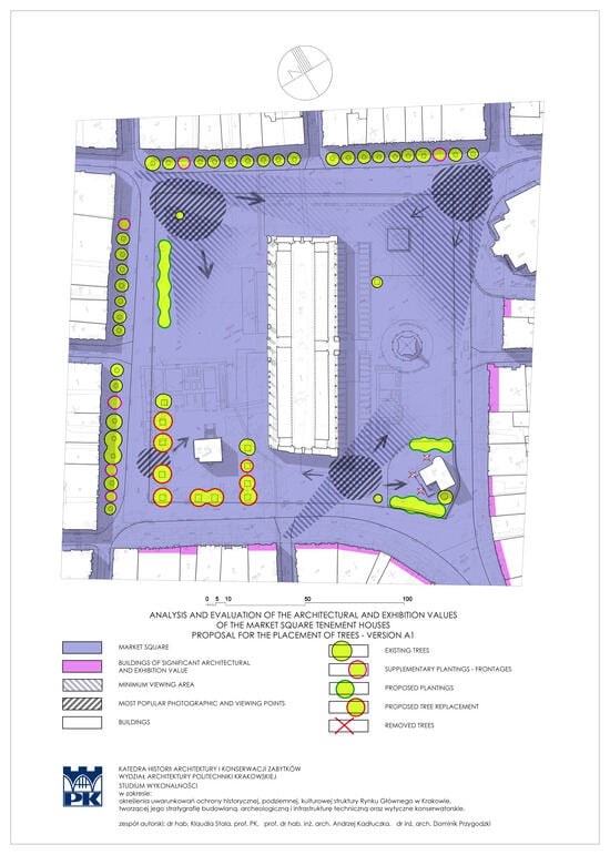
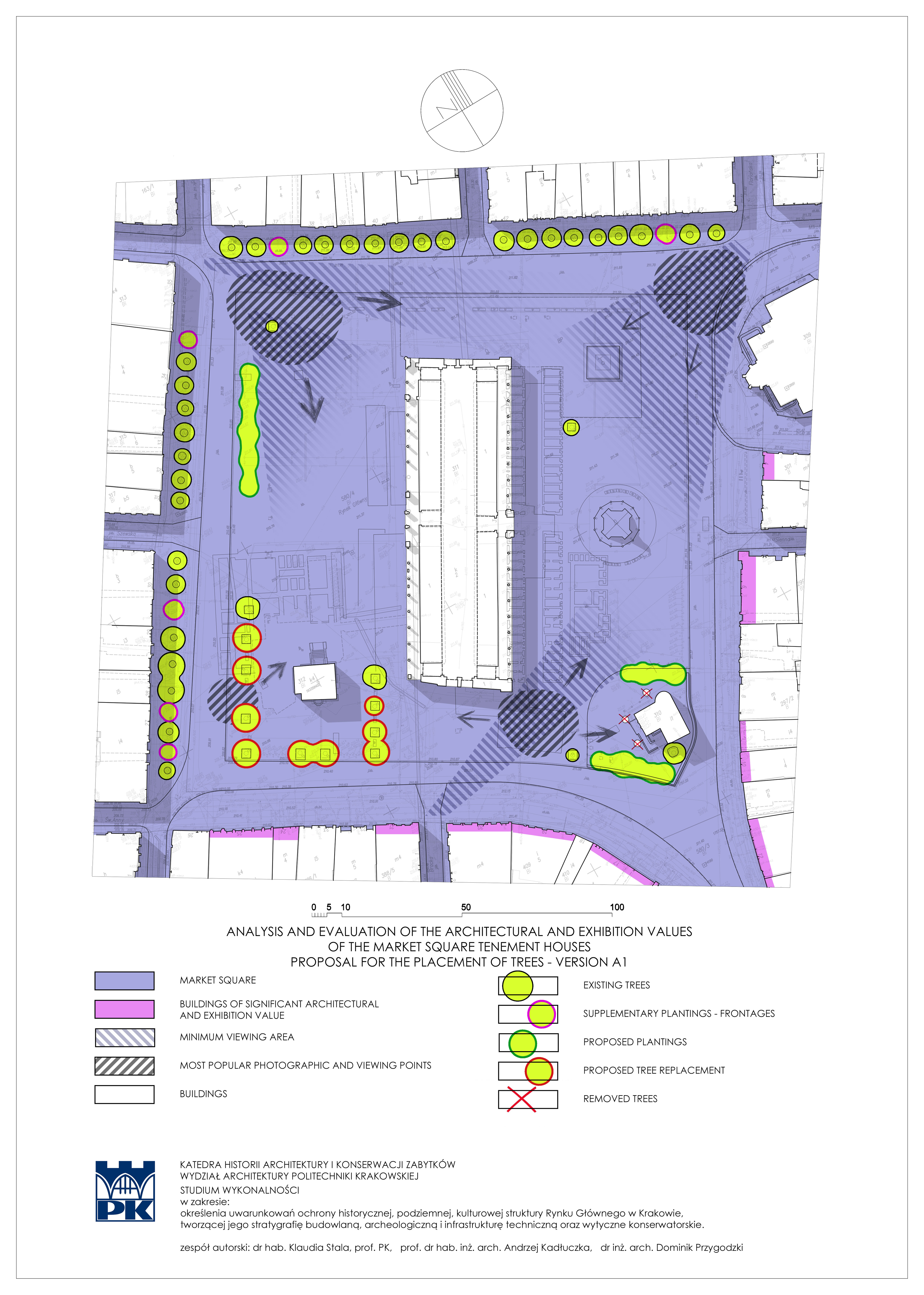
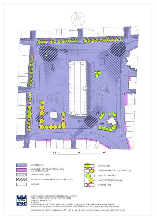
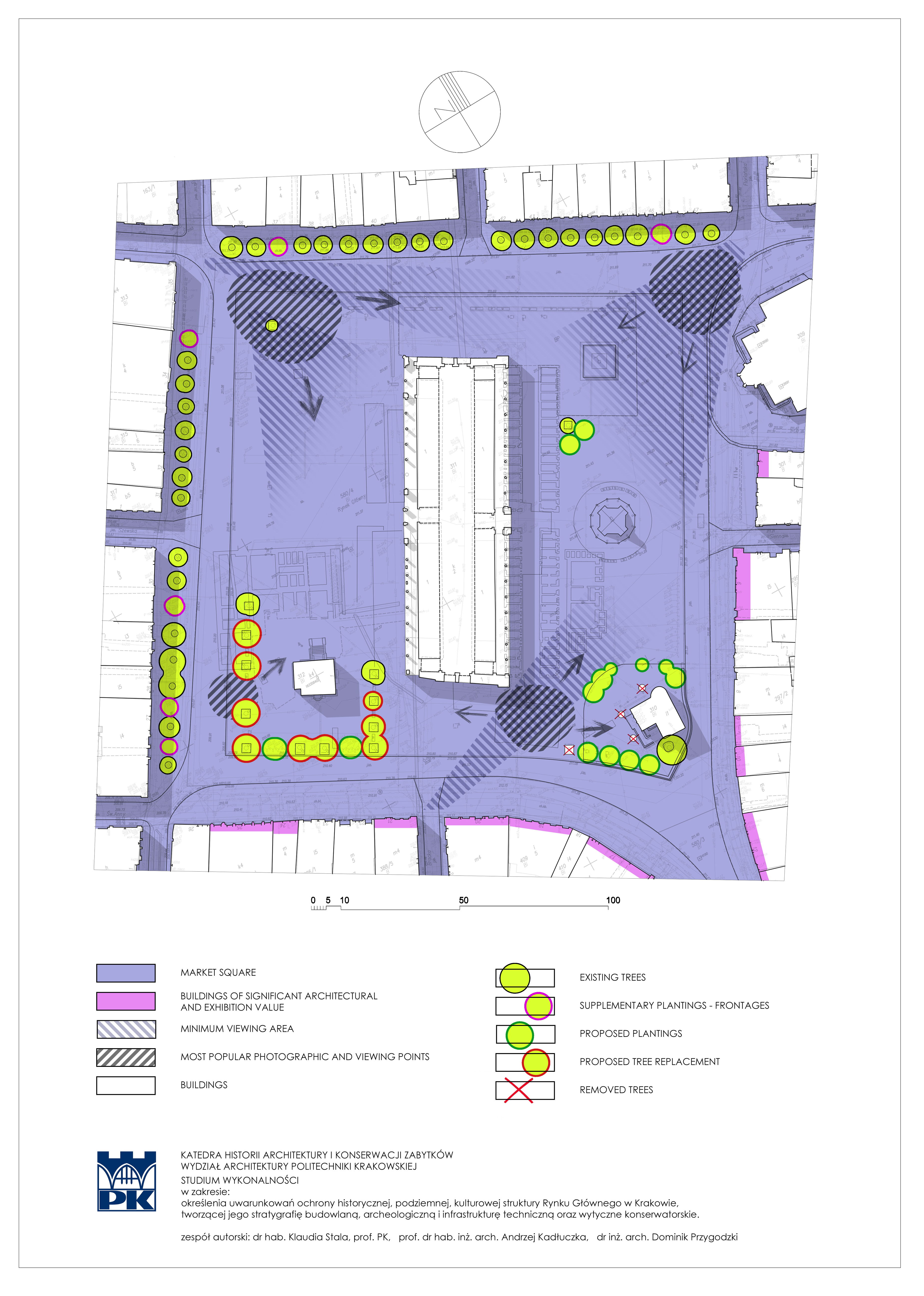
The remaining planting sites were approved, and the project was completed and prepared for handover to the contractor. At the final stage, another, this time unexpected, exclusion of the area prepared for the project took place, which significantly reduced the design concept as well as composition conception (Figure 8 and Figure 9).
Figure 8.
Version of the tree planting proposal that was submitted to the Heritage Conservation Authority for approval. Legend below, at the bottom of the page information about the affiliation of the authors conducting the research: Department of History of Architecture and Monument Preservation Substantive work by A. Kadłuczka, K. Stala, D. Przygodzki, graphic design by D. Przygodzki.
Figure 9.
The final version of the tree planting proposal, following consultations with the Heritage Conservation Authority. Legend below, at the bottom of the page information about the affiliation of the authors conducting the research: Department of History of Architecture and Monument Preservation Substantive work by A. Kadłuczka, author 1, author 2, graphic design by author 2.
10. Conclusions
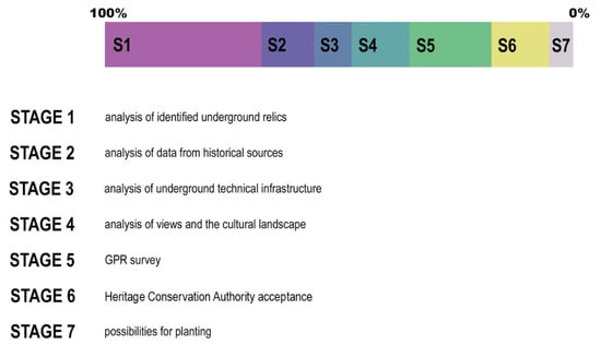
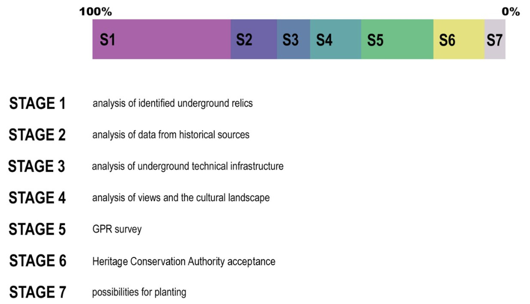
In summary, the analytical process involved in determining the possibility of planting trees in Krakow’s Main Square was lengthy and multifaceted. This was due to the fact that the area in question is sensitive, given its rich cultural stratigraphy, numerous underground technical infrastructures and the strict conservation protection of this space, which is supported by national and international legal acts. The outcome was the identification of a small number of locations that did not raise controversy in relation to the aforementioned factors. This complex case can serve as a model for dealing with historic cities in spaces protected by UNESCO World Heritage status. This paper presents the methodology of this type of work, emphasising the importance of introducing stages of work and aspects necessary for analysis. It also shows how the planned scope of the area selected for planting was reduced as the project progressed to subsequent stages (Figure 10).
Figure 10.
Table showing the stage method of the research process, substantive and graphical work K. Stala and D. Przygodzki.
The project’s transition phases comply with legal regulations in Poland regarding the protection of historical monuments and cultural landscapes, UNESCO World Heritage List inclusion, and technical infrastructure management and access regulations, as well as fire safety regulations. These guidelines were mandatory and were used to specify the sequence of phases. The final project proposal is reviewed by the chief provincial conservator in accordance with the procedure. He has the final say and bears legal responsibility for the solutions adopted regarding heritage safety. The authors of the study adapted the legal criteria to this specific case. Nevertheless, these stages can be applied to similar projects concerning the conservation and protection of historic city squares, provided the specific characteristics of the area in question are taken into account prior to the planting of greenery (Table 1). In this case, two equally detailed criteria were used for Stage 1, which involved analysing underground remains of historic structures. The first criterion relates to the location of the underground museum. This criterion will not be applicable to other similar projects as it pertains to the specific circumstances of this area.
Table 1.
Decision rule matrix for identifying prospective tree planting locations in historical urban spaces.
There is currently no equivalent in Poland, although such solutions may emerge in the future. The entire museum area was excluded because the space above the museum is unsuitable for planting due to the reinforced concrete ceiling structures, the eastern load-bearing wall and legal regulations related to the museum’s operational safety. These regulations also necessitated the establishment of a buffer zone ensuring a minimum distance of 1.5 m from the outer underground load-bearing walls of the museum to ensure access during repair work related to the building’s condition or technical infrastructure. The second specific criterion concerned an analysis of the archaeological surveys conducted on the site. Where underground remains of historical structures were documented, planting trees above them was ruled out, as the remains were located too shallowly—just beneath the modern surface levelling layers, i.e., between 80 cm and 1.5 m. At this stage, the option of planting trees directly in the ground—as proposed by the community project—was ruled out because there were so many underground structures that allowing uncontrolled root growth posed a risk of damaging the historic substance. Therefore, special protective barriers inserted into the ground were proposed to prevent roots from penetrating deeper into and spreading across the soil. Our decisions were based on historical experience. In the 19th century, at a time when the principles of historic preservation were just beginning to take shape worldwide, and public awareness of the archaeological heritage hidden beneath the market square’s surface and its value was low, trees were planted in various parts of the square; these were not removed until 1962, following archaeological and architectural surveys. The research revealed the extent of the damage caused by the spreading trees. The decisions we made also stemmed directly from Polish laws regarding heritage protection, such as the Act of 23 July 2003, on the Protection and Care of Historic Monuments [37]. At this stage, it was decided that a safe distance from underground structures that must be avoided during planting is 1 m; this is the distance at which the edge of the trench should be located for planting trees in the protective sleeves mentioned above.
In Stage 2, an analysis of historical sources made it possible to identify additional areas where remnants of the market square’s historic structures are likely to be found. This primarily concerned Block IV, where wooden market stalls were marked on Austrian maps. A large portion of this block was excluded due to the remains of wooden structures shown on the plans and the fact that most of this area had not yet been excavated. According to the law, the entire archaeological heritage, including preserved cultural layers, is subject to conservation protection. The need to protect the cultural layers, which remain largely intact in this block, necessitated the exclusion of this area. Assuming that the 19th-century military plans are accurate—as evidenced by numerous Austrian documents concerning, among other things, the Kraków Fortress—we determined that there is a safe area for planting trees in this block, located along the edge of the roadway at a distance from the presumed relics consistent with the previously established criterion. We ensured the safety of the archaeological layers by adopting the criterion that planters with trees would not be placed in the ground deeper than 80 cm to 1 m—that is, they would be located within the modern levelling and subbase layers on which the paving stones were laid. Thus, the specific criterion for planting trees within the archaeological layer protection zone was the maximum depth at which no cultural layers were present. We obtained precise data from the design documentation for the market square’s pavement replacement. In the case of Kraków, a depth of 1–1.2 m was sufficient for the selected tree species to establish healthy root systems. This depth allowed for the preservation of a 20–30 cm modern layer separating the planting pit from the historical stratigraphy. Despite the analysis of the plans, it was necessary to verify their accuracy and the exact locations of the relics using GPR surveys.
Stage 3 involved an analysis of the layout of underground utility infrastructure. For this stage, existing documentation on the layout of water, electricity, and gas lines was used, and GPR surveys were conducted to verify the locations of service connections. Non-invasive surveys made it possible to locate inactive utility lines that were suitable for removal. In the case of active utility networks, consultations were held with the relevant authorities regarding the possible relocation of infrastructure that was in potential conflict with tree planting. Where consent was not obtained, an additional exclusion zone was established.
Stage 4 required the protection of the views and cultural landscape inscribed on the UNESCO World Heritage List. Detailed guidelines are set forth in the UNESCO World Heritage Site Management Plan for the Historic Centre of Kraków for 2023–2035 [38]. Other legal mechanisms for the protection of views in Kraków include the View Study and Local Spatial Development Plans (MPZP), the Old Town Cultural Park, the View Study, and the Protection Plan.
Stage 5 consisted of ground-penetrating radar surveys. Their results confirmed the identification based on historical sources. Only in Quarter 4 was the location of the wooden structures verified against Austrian documentation, and a correction was made due to the presence of relics in the area planned for tree planting. The identified relics were located at a depth of 2 m. Based on the depth criterion of 1 m for tree planting established above, both the protection of the relics and the archaeological layers would have been ensured in this case. Only at the location designated for planting tree No. 3 was an anomaly detected shallowly within the 1 m boundary zone. The shape of the anomaly differed from the other clearly discernible outlines of the stalls, and the echogram indicated that the material was compacted. Therefore, a prerequisite for planting tree No. 3 was to conduct an archaeological test excavation and unequivocally determine whether the structure was historical or modern.
In Stage 6, permission from the Heritage Conservation officer to conduct the survey was not granted, which ruled out the possibility of planting at the conflict site. Permission was also not granted to plant the remaining trees in the row, despite the positive results of Stage 4 and the safe solutions proposed in Stage 5. The Heritage Conservation officer deemed this location too problematic.
Stage 7: Progressing through the individual stages led to a significant reduction in the number of locations where trees could be planted and, consequently to a reduction in the number of trees. It was demonstrated just how complex and multifaceted the issue of planting trees in a historic district can be. This is particularly true given the rich and complex archaeological stratigraphy, which contains numerous remnants of underground architecture. The effect intended in the community project was not achieved. With the number of trees approved for planting, the desired effect of reducing heat on the market square will not be achieved. From a conservation perspective, trees planted in a historic square are not a desirable element because they are inconsistent with the ideas underlying its historical function and undermine the authenticity of the site’s identity. A clear conflict of interest is emerging here between the thermal comfort of residents and tourists and the protection and preservation of the historic area. Our intention as the authors of this research is to demonstrate how important it is to strive for a balance between objectives and solutions, taking into account both the needs expressed by residents—such as increasing the amount of greenery in the market square—and the protection of valuable historical heritage, as well as preserving the function of the city’s main square and the accompanying need to host public and cultural events. In the case of Kraków’s Market Square, it can be said that the existing arrangement with trees along the square’s perimeter provides optimal shelter for both residents and tourists, leaving the square’s central space virtually free of greenery. The exception is the area around St Adalbert’s Church, which has historical and symbolic justification related to the cemetery surrounding the church, as well as the area along the former walls of the town hall. The Market Square itself is not a place intended for prolonged stays; restaurants and other services are concentrated primarily in the vicinity of the aforementioned tree-lined frontages. It should be added that in the 19th century, when the city walls were demolished (with the exception of the preserved northern section on the side of the barbican), the moat was filled in, and a city park with greenery—including tall trees—was created in its place to surround the Old Town. It might be worth considering whether more trees should be planted in this area, after first exploring the possibility of creating better thermal, climatic, and ecological conditions for the tenement houses and their surroundings within the historic district.
11. Summary
The interdisciplinary approach required for this type of analysis was demonstrated from the outset, with activities focusing on the conservation and protection of architectural and archaeological heritage. Our team included an archaeologist specialising in archaeology and cultural landscapes, with expertise in archaeological research, the history of architecture and urban planning, and the protection of cultural heritage. Our team also included architectural historians who are practising architects specialising in the design of historic buildings and architectural conservation. The other two teams consisted of landscape architecture experts, with one team focusing on the analysis of views and the compositional design of trees and the other on selecting appropriate tree species and planting technologies. The work of our team in the area of archaeological and architectural heritage, and the inviolability of legal aspects related to the market square as a historic space, formed the basis for further proceedings.
The work was supported by non-invasive geophysical surveys and new technologies such as LIDAR and TLS. These are now essential tools in the research and documentation process, particularly in urban planning. In today’s world, where climate change is advancing rapidly, there is an increasing need to plant trees in open urban spaces, a concept that is becoming more widely accepted and supported by residents, as demonstrated by the aforementioned grassroots social initiative. However, in cities with a rich history, especially in city squares which have historically served administrative and commercial functions, followed by representative functions, the issue of planting can be problematic. This starts with the historical character of the square and its function in the urban space and ends with the legal protection of historical heritage. The market square in Krakow is an extremely complex example due to its rich history of transformations that have taken place over the centuries.
The authors hope that this case will stimulate further discussion on the rules of conduct for such projects and raise awareness of the need for a different approach to historic city squares in climate policy. They also hope to highlight the necessity of developing standards that differ from those applied to other areas of the city.
Author Contributions
K.S.: conceptualization, research, formal analysis of research results methodology, writing—original draft preparation 50% of contribution, D.P.: research, draft preparation, graphic work 40% of contribution, W.B.: vegetation research, preparation of planting solutions 10% of contribution. All authors have read and agreed to the published version of the manuscript.
Funding
The authors declare that their research institution was commissioned to conduct preliminary research by the Municipality of Krakow, which covered the costs of the research.
Data Availability Statement
No new data were created or analysed in this study. Data sharing is not applicable to this article.
Acknowledgments
The authors would like to thank Agata Zachariasz a head of the overall research, and other team members: Z. Myczkowski, U. Forczek-Brataniec and A. Greniuk, M. Bogdanowicz, P. Koppel-Nosalska. We would like to extend special thanks to A. Kadłuczka, who served as a consultant for this research and project for sharing his knowledge and experience with us, and A. Pleśniarski for his technical support.
Conflicts of Interest
The authors declare no conflicts of interest.
References
- Opaliński, P.; Kowalski, M. 3D Reconstruction of the Main Market Square in the Half of the 15th Century. Available online: https://muzeumkrakowa.pl/kufer-zycie-codzienne-w-sredniowiecznym-miescie (accessed on 28 August 2026).
- Krakow Market Square 3D High Quality, Atlas 3D. 2020. Available online: https://sketchfab.com/3d-models/krakowski-rynek-3d-wysoka-jakosc (accessed on 2 February 2026).
- Łuszczkiewicz, W. Dawny romański kościół św. Wojciecha na podstawie własnych zdjęć i badań. Rocz. Krak. 1900, 3, 153–172. [Google Scholar]
- Jamka, R. Wyniki badań wykopaliskowych przy romańskim kościele św. Wojciecha w Krakowie w 1934 roku. Mater. Archeol. 1964, 5, 211–223. [Google Scholar]
- Żaki, A. Wstępne badania archeologiczne na terenie Krakowa w latach 1950–1955 (Seria I–II). Spraw. Archeol. 1957, 3, 154–164. [Google Scholar]
- Zaitz, E. Badania Archeologiczne W Sukiennicach I Na Rynku Głównym W Krakowie; Krzysztofory 28: Kraków, Poland, 2010; Volume cz.I, pp. 199–254. [Google Scholar]
- Radwański, K. Prace ratownicze prowadzone przez Konserwatora Zabytków Archeologicznych w Krakowie w latach 1955–1958. Biul. Krak. 1959, 1, 49–57. [Google Scholar]
- Dębowski, T. Kraków—Sukiennice. Inf. Archeol. Badania 1975, 249–250. [Google Scholar]
- Radwański, K. Kraków Przedlokacyjny Rozwój Przestrzenny; Polskie Towarzystwo Archeologiczne i Numizmatyczne, Oddział w Nowej Hucie, Muzeum Archeologiczne w Krakowie: Kraków, Poland, 1975. [Google Scholar]
- Zaitz, E. Report on Archaeological Research Carried out in the Vicinity of the Church of St. Adalbert in 1992; Archaeological Museum in Krakow, Department of Archaeology of the Middle Ages and Modern Times: Kraków, Poland, 1992. [Google Scholar]
- Zaitz, E. Results of Archaeological Research Carried out in 1994 in the Cloth Hall (Excavation 19–30); Archaeological Museum in Krakow, Department of Archaeology of the Middle Ages and Modern Times: Kraków, Poland, 1994. [Google Scholar]
- Zaitz, E. Sprawozdanie z badań archeologicznych prowadzonych w Krakowie w 2004 roku przy przebudowie nawierzchni płyty Rynku Głównego po zachodniej stronie Sukiennic. Mater. Archeol. 2006, 36, 79–142. [Google Scholar]
- Łukacz, M. Badania architektoniczne reliktów murowanej zabudowy pod zachodnią częścią płyty Rynku Głównego w Krakowie. Mater. Archeol. 2006, 36, 143–167. [Google Scholar]
- Białasik-Bojęś, A.; Zaitz, M. Kramy drewniane odkryte w 2004 roku po zachodniej stronie Sukiennic na Rynku Głównym w Krakowie. Czas. Tech. 2011, 7A, 99–118. [Google Scholar]
- Zaitz, E. Report on Archaeological Research Main Market Square, Church of St. Adalbert; Archaeological Museum in Krakow, Department of Archaeology of the Middle Ages and Modern Times: Kraków, Poland, 2004. [Google Scholar]
- Buśko, C. Z badań archeologicznych nad miastami południowej Polski. Rynek Główny w Krakowie w świetle prac przeprowadzonych w latach 2005–2007. Archaeol. Hist. 2007, 32, 225–235. [Google Scholar]
- Buśko, C.; Głowa, W. Osada przedlokacyjna na Rynku Krakowskim. Krzysztofory 2010, 28, 145–152. [Google Scholar]
- Dryja, S.; Głowa, W.; Niewalda, W.; Sławiński, S. Rynek Krakowski po lokacji—Główne kierunki rozwoju bloku śródrynkowego. Krzysztofory 2010, 28, 99–112. [Google Scholar]
- Buśko, C.; Głowa, W.; Dryja, S.; Sławiński, S. Główne kierunki rozwoju Krakowskiego Rynku Głównego od poł. XIII wieku po początek XVI wieku. Czas. Tech. 2011, 7A, 49–66. [Google Scholar]
- Kadłuczka, A. Projekt nowej nawierzchni Rynku Głównego w Krakowie i modernizacji jego infrastruktury podziemnej. Wiad. Konserw. 2004, 16, 5–12. [Google Scholar]
- Kadłuczka, A. Idea rezerwatu średniowiecznej architektury w Rynku Głównym. Renowacje Zabyt. 2006, 4, 16–19. [Google Scholar]
- Kadłuczka, A. Podziemne Muzeum Rynku Głównego w Krakowie; Wydawnictwo PK: Kraków, Poland, 2010; p. 40. ISBN 978-83-7242-575-1. [Google Scholar]
- Kadłuczka, A. Rynek Główny W Krakowie: Podziemne Muzeum W Aspekcie Architektoniczno-Konserwatorskim. In Florencja I Kraków: Miasta Partnerskie W Europie—Wspólne Dziedzictwo Kultury, Proceedings of the International Conference Organized as Part of the Celebration of the 750th Anniversary of the Location of Krakow, Kraków, Poland, 21–22, 25–27 September 2007; Jasieńko, J., Kadłuczka, A., Mandelli, E., Eds.; Towarzystwo Autorów i Wydawców Prac Naukowych UNIVERSITAS: Kraków, Poland, 2010; pp. 399–450. ISBN 97883-242-0964-4. [Google Scholar]
- Stala, K. The archaeology of the Main Market Square in Krakow and its implications for using historical public spaces in a new way. In Reuso: La Experiencia del Disfrute: Nuevos Usos en Monumentos: [Propuestas Internacionales para la Documentación, Conservación y Reutilización del Patrimonio Arquitectónico]; Mora, A.-M.S., de la Plata Adela Rueda, M., Cruz Franco Pablo Alejandro, C.F.P., Eds.; La Experiencia del Reuso; c2o Servicios Editoriales: Cáceres, Spain, 2013; pp. 329–332. ISBN 978-84-15321-72-9. [Google Scholar]
- Stala, K. The role and significance of archaeological heritage in the contemporary urban space. Czas. Tech. Archit. 2015, 6A, 197–215. [Google Scholar]
- European Arboricultural Standards. European Tree Assessment Standard; Working group “European Consulting Standards in Tree Work” (ECoST): Kolín, Czech Republic, 2025; Volume 4. [Google Scholar]
- Zin, W.; Grabski, W. Early medieval buildings of Krakow in the light of recent research. Rocz. Krak. 1966, 38, 33–73. [Google Scholar]
- Komorowski, W.; Sudacka, A. Rynek Główny W Krakowie; Ossolineum: Wrocław, Poland, 2008. [Google Scholar]
- Rożek, M. Przewodnik Po Zabytkach Krakowa; Wydawnictwo Apostolstwa Modlitwy: Kraków, Poland, 2010; p. 44. [Google Scholar]
- Grabski, W. Problemy genezy i rozwoju renesansowego pałacu miejskiego w Krakowie. Archit. Zesz. Nauk. Politech. Krak. 1968, 21, 128–132. [Google Scholar]
- Gliński, R. Średniowieczny i wczesnonowożytny dom mieszczański w małym i średniej wielkości mieście śląskim—Zarys problematyki badawczej. Quart 2013, 4, 3–19. [Google Scholar] [CrossRef] [Scilit]
- Kadłuczka, A. Teoretyczne I Techniczne Aspekty Podziemnych Rezerwatów Architektonicznych Na Przykładzie Rynku Krakowskiego; Politechnika Krakowska (mpis, Biblioteka PK): Kraków, Poland, 1975. [Google Scholar]
- Kadłuczka, A. Rezervat kao metoda zastite i prezentacije arhitektonskih spomenika kulture. Inform. Museol. 1984, 4, 8–31. [Google Scholar]
- Kadłuczka, A. Relikty monumentalnej zabudowy Rynku krakowskiego: Ocena stanu zachowania i możliwości ekspozycji. Ochr. Zabyt. 1995, 48, 13–19. [Google Scholar]
- Bobek, W. Nowoczesne technologie budowlane wykorzystywane podczas wprowadzania drzew w silnie przekształconych przestrzeniach miasta. Czas. Tech. Archit. 2010, 8A, 269–277. [Google Scholar]
- Pleśniarski, A.; Gacek, P.; Woźniak, M. Raport Documentation of GPR and LIDAR Scanning, Projekt: 24-420-kr, Inventory of Underground Infrastructure Using GPR Techniques, Precision Radiodetection and 3D Scanning in Krakow as Part of the Task Entitled: “Let’s Plant Trees on the Main Market Square”. Gdynia, Poland. 2024, Unpublished Work. Scan 3D Szymon Bloch ul. Kadłubowców 2 lok. 4.21, 81-336 Gdynia—POLAND. Available online: www.scan-3d.pl (accessed on 17 September 2026).
- Ustawa z dn. 23 Lipca 2003 Roku o Ochronie Zabytków i Opiece nad Zabytkami. 2026. Available online: https://isap.sejm.gov.pl/ (accessed on 17 September 2026).
- Wytyczne do Zarządzania Historycznym Centrum Krakowa, Miejscem Światowego Dziedzictwa UNESCO na Lata 2023–2035. 2026. Available online: https://www.bip.krakow.pl/zarzadzenia (accessed on 17 September 2026).

Disclaimer/Publisher’s Note: The statements, opinions and data contained in all publications are solely those of the individual author(s) and contributor(s) and not of MDPI and/or the editor(s). MDPI and/or the editor(s) disclaim responsibility for any injury to people or property resulting from any ideas, methods, instructions or products referred to in the content. |
© 2026 by the authors. Licensee MDPI, Basel, Switzerland. This article is an open access article distributed under the terms and conditions of the Creative Commons Attribution (CC BY) license.