


Abstract
Sustainable urban stormwater management requires planning tools that quantify local retention potential while accounting for limited street space and existing infrastructure. This study develops a planning-level framework for selecting and preliminarily sizing blue–green infrastructure (BGI) to support sustainable water and land management in existing streetscapes. A section of Henryka Wolińskiego Street in Lublin, Poland, was divided into 26 sub-catchments. Runoff was estimated from land cover, runoff coefficients, and a 15 min design rainfall depth of 16.13 mm with an annual exceedance probability of 20%, obtained from the PMAXTP model. Rain gardens, infiltration swales, stormwater curb extensions, and bioretention basins were allocated according to spatial, environmental, and infrastructure constraints. Calculated runoff was equivalent to 7.4 mm over the study area. The proposed facilities provided 6.8 mm of design storage and could accommodate 6.6 mm, or 89.4% of calculated runoff, under the adopted assumptions; 0.8 mm, or 10.6%, required sewer discharge. Unused storage coexisted with local deficits, demonstrating the importance of storage location and feasible hydraulic connections. The framework contributes a transparent decision-support procedure for assessing the water-management dimension of urban sustainability through runoff accommodation, residual sewer discharge, and BGI space requirements. These are design estimates, not measured environmental benefits or a comprehensive sustainability assessment. Application elsewhere requires local input data, field verification, and subsequent performance monitoring.
1. Introduction
Progressive urbanization leads to the transformation of natural and semi-natural surfaces into built-up and sealed areas, which significantly changes the local water cycle. Reducing infiltration and retention while accelerating surface runoff increases the burden on storm sewerage systems and the risk of local flooding. This problem is particularly important in the context of the observed increase in the frequency of extreme weather events, including both intense rainfall and periods of drought [1,2]. Contemporary rainwater management therefore requires an approach that is not limited to draining water from the urban area as quickly as possible, but seeks to retain it, use it and, where ground-water conditions allow, infiltrate it as close as possible to the precipitation site [3,4].
One of the directions for the implementation of this approach is blue-green infrastructure (BGI), which uses solutions modelled on natural processes for capture, temporary storage, infiltration, evapotranspiration and rainwater treatment [5,6]. Solutions used in urban spaces include, among others, rain gardens, infiltration swales, infiltration basins, bioretention facilities and stormwater curb extensions [7,8,9,10,11]. In contrast to the conventional drainage approach, BGI allows for the partial restoration of hydrological processes limited by surface sealing, and at the same time can provide additional environmental and spatial benefits [5,12]. Contemporary research also points to the importance of bioretention for improving rainwater quality and reducing pollutant transport [13,14,15,16].
In this study, the sustainability perspective concerns the management of runoff within existing urban land constraints. Local retention can support a shift towards treating stormwater as a resource within the urban water cycle [3,4,12]. A useful planning assessment must therefore connect the quantity of runoff requiring management with the land and infrastructure needed to accommodate it. This addresses one environmental and technical dimension of sustainable development; it does not, by itself, establish the overall sustainability of a proposed intervention.
Particular possibilities for implementing BGI occur in street spaces. Streets are extensive, largely sealed surfaces generating runoff, and at the same time include green belts, parking lots, pavements and other spaces in which, under appropriate technical conditions, retention elements can be introduced [17,18]. Such solutions can take water from roadways and other impermeable surfaces, limiting its direct discharge into the sewage system. However, their use in the existing urban fabric is conditioned not only by hydrological needs, but also by the availability of space, terrain, properties of native soil, location of the groundwater table and the course of underground technical infrastructure [19]. This means that one type of BGI solution cannot be used equally in all sections of the street [20,21].
BGI selection and placement depend on local hydrological, spatial, and infrastructural conditions [19,20,21,22]. Previous studies emphasize the importance of planning individual facilities as interconnected systems [23,24,25]. However, a planning-level gap remains in linking sub-catchment runoff estimates and storage requirements with the space available for different BGI types and opportunities to transfer excess runoff between adjacent facilities. Addressing this gap requires an approach that combines runoff calculations with site-specific design constraints.
This study aimed to develop and apply a planning framework for sustainable stormwater management through the selection and preliminary sizing of blue–green infrastructure in existing streetscapes. Applied to a section of Henryka Wolińskiego Street in Lublin, Poland, the framework combines sub-catchment runoff estimates with spatial constraints and opportunities for transferring excess runoff between facilities. Its contribution to sustainability is a transparent assessment of how much design-event runoff can be accommodated locally, how much requires sewer discharge, and where limited space or hydraulic connectivity constrains retention. These outputs support decisions on the allocation of urban land to decentralized stormwater management. The assessment concerns design storage capacity under a specified rainfall event; operational performance and wider sustainability outcomes were not measured.
2. Materials and Methods
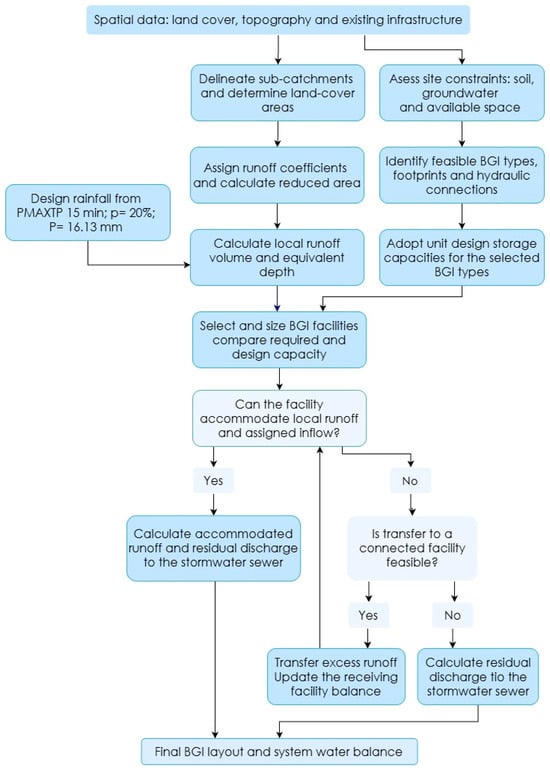
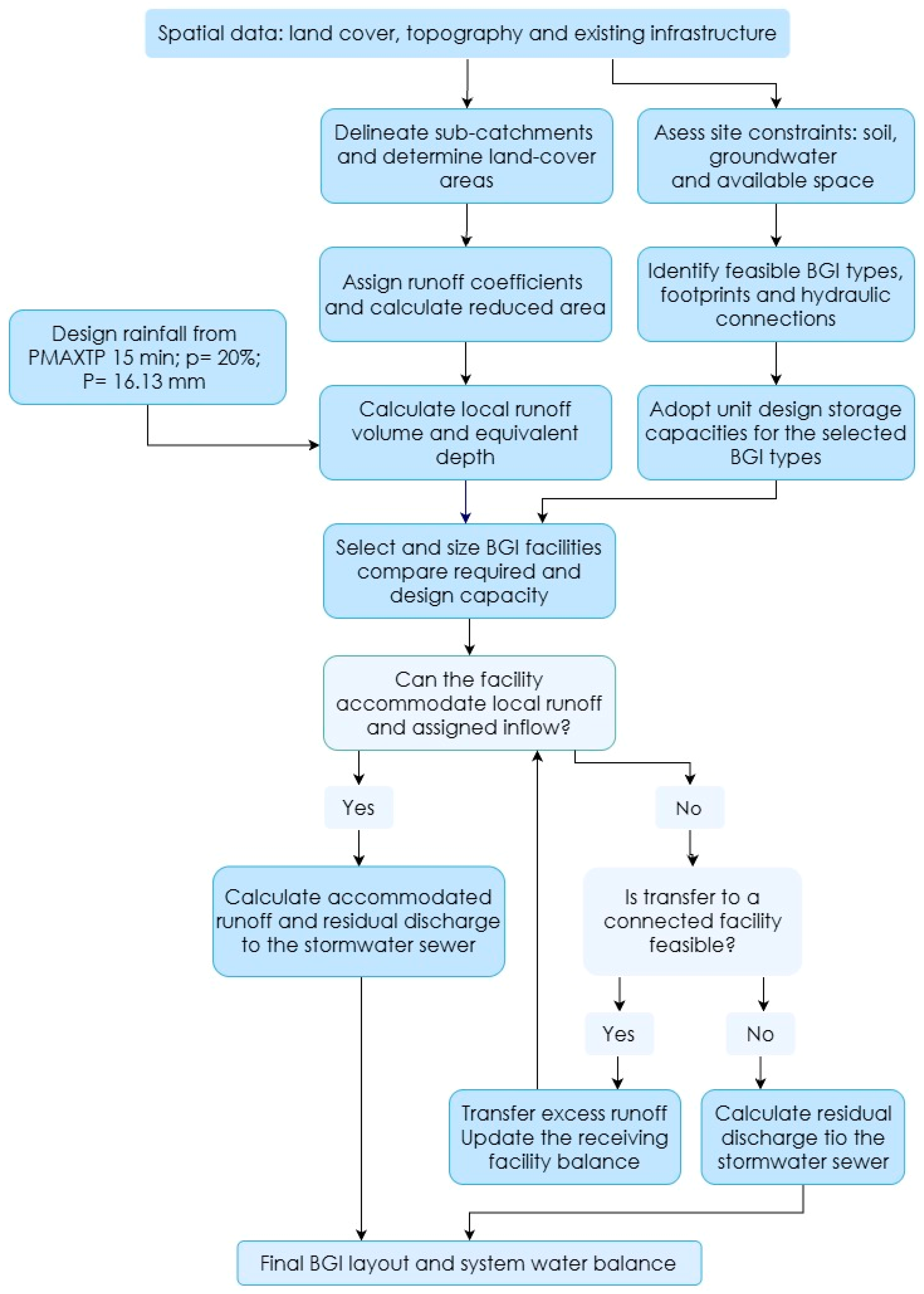
The analysis combined site information with literature-based runoff coefficients and unit storage capacities. Sub-catchments were delineated using surface slopes and runoff directions. Runoff was calculated for a common design rainfall event. BGI types and footprints were then selected according to available space, site conditions, and existing infrastructure. Facility balances included local runoff and, where connections were proposed, excess runoff transferred from adjacent facilities. Figure 1 presents the computational and spatial workflow.
Figure 1.
Computational and spatial workflow for selecting and sizing BGI facilities and balancing runoff across connected sub-catchments (prepared by the authors).
2.1. Study Area
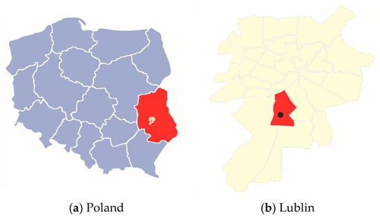
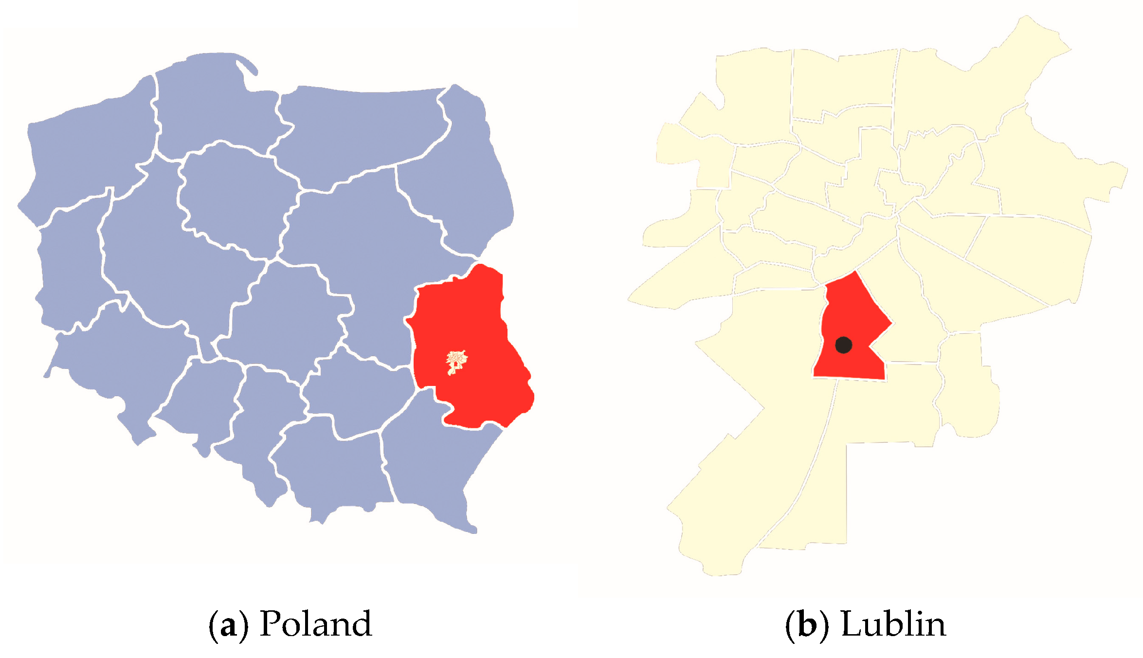
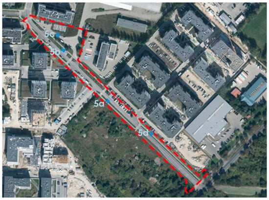
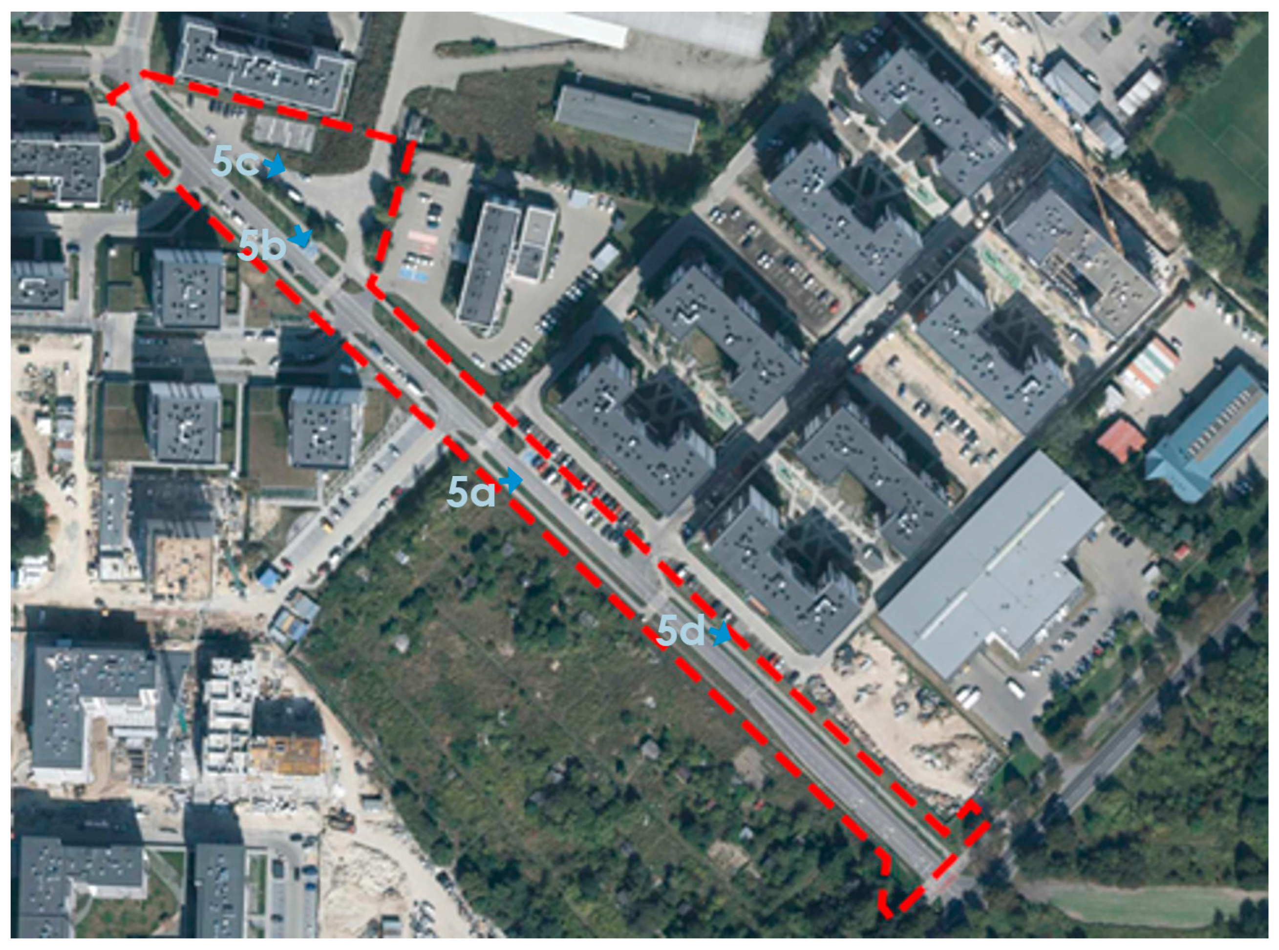
The study covers 10,339.4 m2 of roadside land along Henryka Wolińskiego Street in the Wrotków district of south-eastern Lublin, Poland (51°12′13.89″ N, 22°33′30.96″ E). It extends between Bernarda Wapowskiego Street to the north-west and Zemborzycka Street to the south-east (Figure 2 and Figure 3). The study boundaries generally follow cadastral parcels to limit ownership-related implementation constraints. In the south-eastern section, they follow pavement kerbs to maintain catchment coherence.
Figure 2.
Location of the study area: (a) Poland, with Lubelskie Voivodeship highlighted in red and Lublin marked within it; (b) Lublin, with the district containing the study site highlighted in red. The black dot indicates the study site (prepared by the authors).
Figure 3.
Enlarged view of the study area along Henryka Wolińskiego Street, shown on the 2023 imagery presented at a broader spatial extent in Figure 4c. The red dashed line marks the boundary of the conceptual BGI design area. Markers (a–d) indicate the locations of the photographs presented in Figure 5, with arrows showing the viewing directions [26].
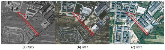
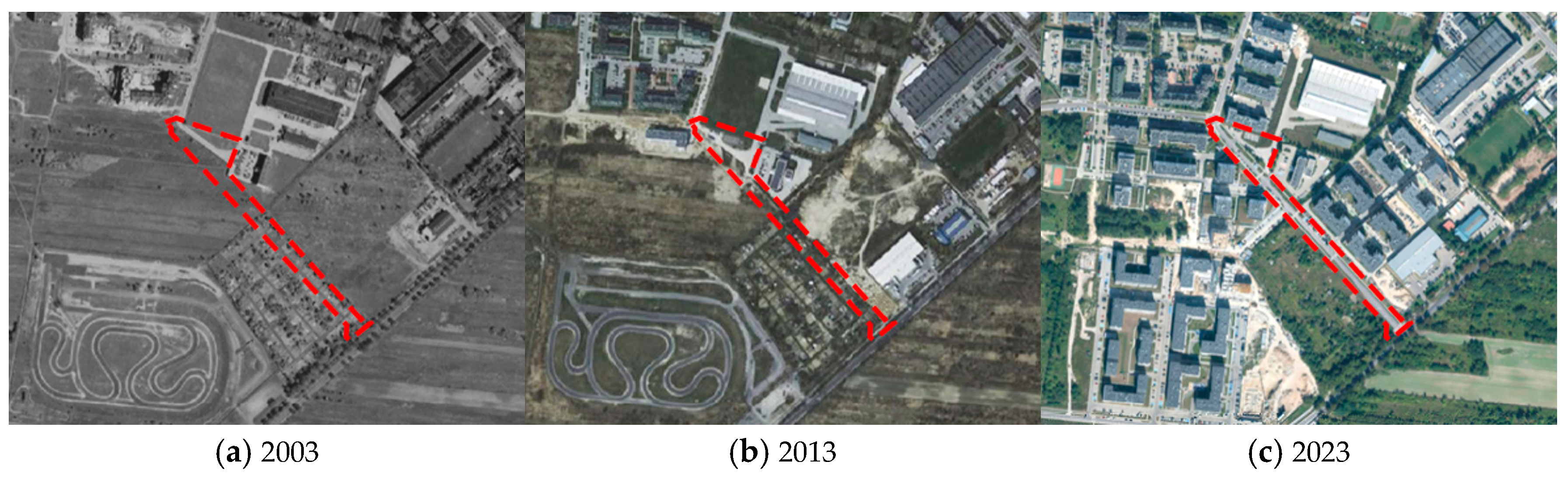
Orthophotomaps from 2003, 2013, and 2023 illustrate the subsequent transformation of the study area and its surroundings (Figure 4) [26]. Figure 3 provides an enlarged view of the study area in 2023, while Figure 4 shows its broader surroundings and changes in land development between 2003 and 2023. Wrotków developed from a village [27] into an area characterized by industrial development and expanding single- and multi-family housing [28]. Its gradual incorporation into the administrative boundaries of Lublin was completed in 2006 [29].
Figure 4.
Historical changes in land development within and around the study area: (a) 2003, (b) 2013, and (c) 2023. The red dashed line marks the same study-area boundary in each panel. An enlarged view of this area in 2023 is provided in Figure 3 [26].
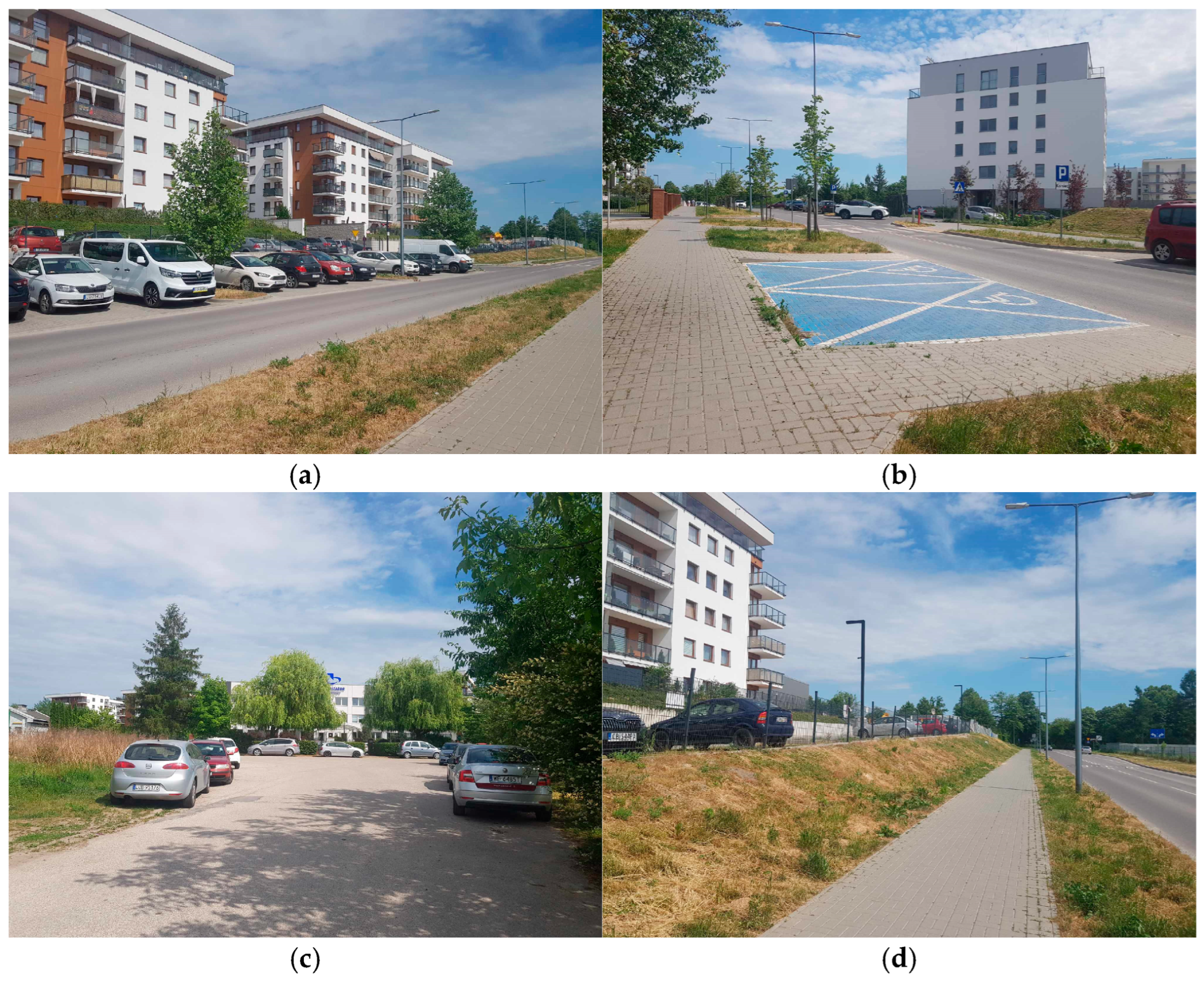
Today, the surrounding area consists mainly of multi-family residential developments, services, and transport infrastructure (Figure 5a–d). Continuing urbanization has increased impervious cover and reduced vegetated areas. These changes, together with the site’s spatial connection to the Bystrzyca River valley, motivated its selection for assessing the potential for streetscape stormwater retention.
Figure 5.
Existing site conditions along Henryka Wolińskiego Street (photo by Katarzyna Bernat, 2024). (a) View of the parking spaces adjacent to the Diamentowe Wzgórze residential development. (b) View of parking spaces designated for persons with disabilities. (c) View of the Black Red White warehouse forecourt and parking area. (d) View of a footway with adjacent vegetated strips along Henryka Wolińskiego Street.
2.2. Design Considerations
2.2.1. Topography
The study area is characterized by gently undulating terrain, with slopes not exceeding 15%. The terrain gradients are oriented towards the Bystrzyca River valley, which facilitates the natural drainage of stormwater [30].
2.2.2. Geological Conditions
In the subsoil of the studied area, there are silty and sandy-silty soils of loess-like origin, lying on Cretaceous formations [31,32]. The characteristics of the soil conditions were used for a preliminary planning assessment of the possibility of applying solutions enabling rainwater infiltration. The geological structure of the subsoil is important both for the possibility of infiltration and for the potential migration of pollutants towards groundwater [33].
2.2.3. Hydrological Conditions
The study area is located within the Bystrzyca River catchment, which plays an important role in the city’s hydrological system [34].
An important hydrogeological condition is the occurrence of a cone of depression associated with groundwater exploitation, which has contributed to lowering the level of the groundwater table and drying out part of the subsoil [35]. According to the available data, the groundwater table in the analysed area is located at a depth exceeding 2 m below the surface [36].
2.3. Research Procedure and Retention Capacity Calculations
The analytical and design process began with the identification of potential locations of blue-green infrastructure (BGI) elements. For this purpose, the degree of surface sealing, terrain, soil and hydrogeological conditions, and the location of existing utilities were analysed [20,21]. These factors were taken into account both in determining the directions of surface runoff and in the subsequent selection of the type, location and mode of operation of the designed retention facilities.
Infiltration feasibility was screened using the identified soil type and the classification provided in the Catalogue of Good Practices [37]. The literature-based hydraulic conductivity range adopted for the loess deposits was 10−5–10−4 m/s [37]. This range supported preliminary consideration of infiltration-based facilities but did not constitute site-specific verification. No field measurements of hydraulic conductivity were performed; unlined designs therefore require local permeability testing and hydrogeological assessment before implementation [19,21,37].
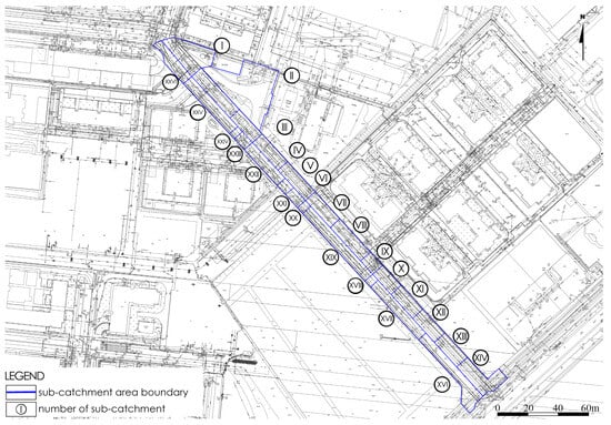
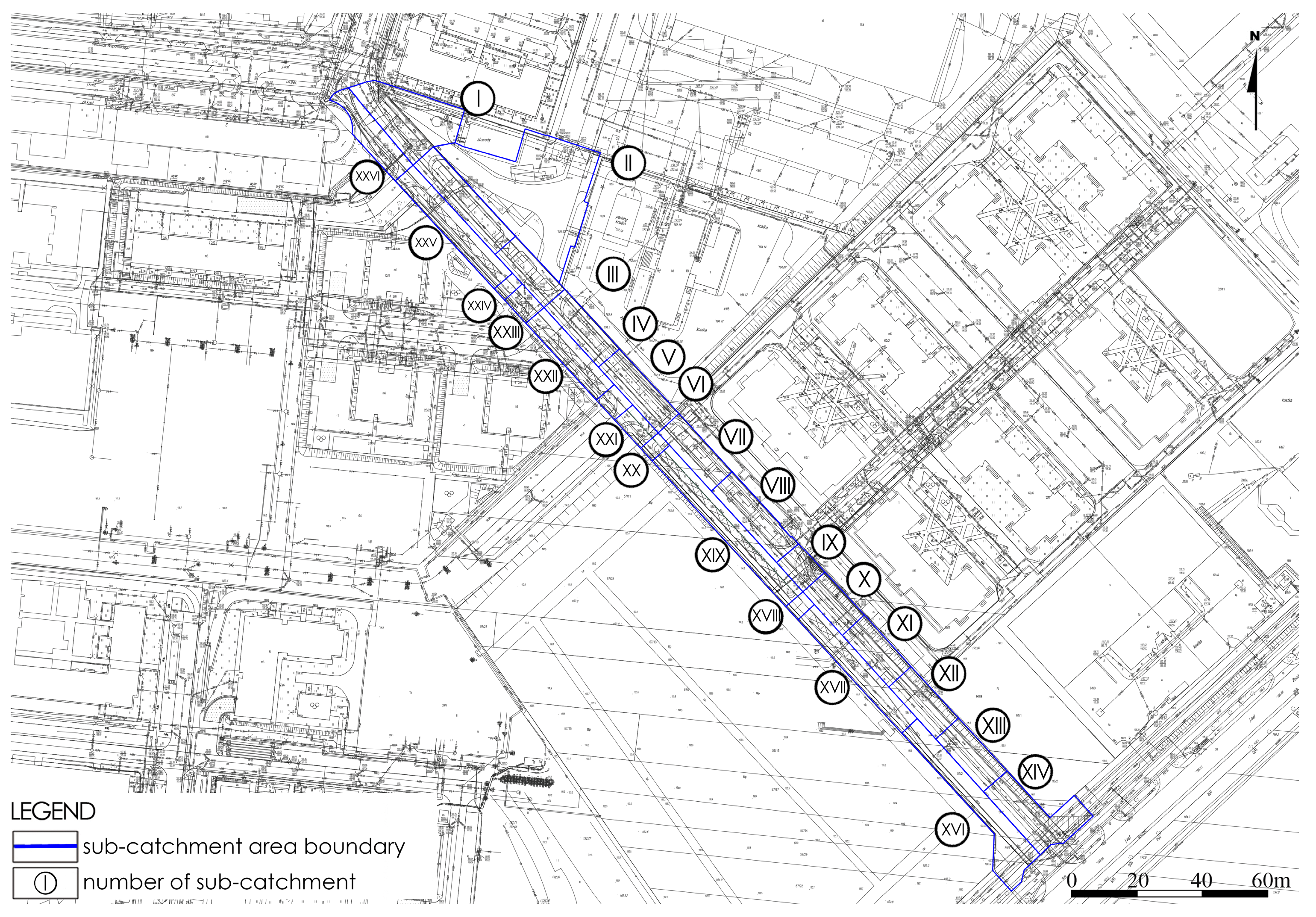
Next, the study area was divided into sub-catchments, understood in this study as spatial units, from which surface runoff is directed to a specific designed BGI facility. The boundaries of sub-catchments were determined on the basis of local terrain, surface slopes and the resulting directions of rainwater runoff (Figure 6). Sub-catchments were the basic spatial units for further hydrological calculations and the selection of retention solutions.
Figure 6.
Map showing the division of the study area into sub-catchments (prepared by the authors).
Dimensionless runoff coefficients (Ψ) of 0.9, 0.8, 0.2, and 0.1 were assigned to asphalt, paved, permeable, and green surfaces, respectively [38,39]. These coefficients represent the fraction of rainfall converted to runoff and were applied consistently across all sub-catchments. No soil- or slope-based adjustments were made because local calibration data were unavailable. Soil conditions informed infiltration feasibility, whereas topography determined sub-catchment boundaries and runoff directions.
On the basis of the standard relationship used to determine the reduced area [38], the reduced area was calculated for each sub-catchment:
where
Fzr—reduced area [m2];
Fi—area of land-cover category i [m2];
—runoff coefficient for this type of surface i [-].
2.3.1. Determining the Volume of Rainfall
Runoff calculations used a 15 min design rainfall event with an annual exceedance probability of p = 0.20, corresponding to a return period of T = 1/p = 5 years. This probability does not imply regular occurrence every five years [40]. The PMAXTP model developed by the Institute of Meteorology and Water Management—National Research Institute provided a rainfall depth of 16.13 mm for the study location [40,41]. The same event was applied to all sub-catchments to provide a consistent basis for facility sizing. For volume calculations, this depth is equivalent to 16.13 L/m2.
2.3.2. Determination of Runoff Volume and Equivalent Runoff Depth
For each sub-catchment, runoff volume was calculated by multiplying the reduced area by the design rainfall depth:
where
Vrunoff = Fzr⋅Pmax
Vrunoff—calculated runoff volume [L];
Fzr—reduced surface area [m2];
Pmax—design rainfall depth [L/m2].
To enable comparison among sub-catchments of different sizes, the calculated runoff volume was converted to an equivalent runoff depth:
where
hrunoff—the equivalent runoff depth [mm];
Vrunoff—the calculated runoff volume [L];
A—the total area of the analysed sub-catchment [m2].
The equation was applied separately to each sub-catchment. Since 1 L/m2 equals 1 mm, dividing runoff volume in litres by sub-catchment area in square metres gives runoff depth in millimetres. The reference area is the total sub-catchment area, not the reduced area or the BGI facility area.
For the entire study area, the equivalent runoff depth was calculated as:
where
Vrunoff,total—the sum of locally generated runoff volumes from all 26 sub-catchments [L];
Atotal—their combined area [m2].
Internal transfers were not counted as additional runoff generation.
2.3.3. BGI Object Retention Capacity and Dimensioning
The required storage volume (Vreq) was defined as the locally generated runoff volume plus any inflow transferred from a hydraulically connected facility. For facilities receiving no transferred inflow, Vreq equals the local runoff volume.
For individual types of BGI, a unit design storage capacity was adopted, expressed in L/m2 of the area of the facility. The parameter means the volume of water used for the design per unit area of a given type of BGI under specific structural assumptions; it does not constitute the measured retention efficiency of the facility. On the basis of the source [37], the calculations assumed a unit retention capacity of 200 L/m2 for rain gardens, 285 L/m2 for infiltration swales and 60–80 L/m2 for stormwater curb extensions and bioretention basins, depending on the type and construction of the analysed solution.
The required area of the BGI facility was determined on the basis of the required retention capacity and the unit capacity of a given solution:
where
ABGI—required BGI facility area [m2];
Vreq—required retention capacity [L];
Cr—unit retention capacity of a given BGI type [L/m2].
If the area of the facility was determined on the basis of the available space, its design storage capacity was calculated using the following equation:
where
VBGI = ABGI⋅Cr
VBGI—design storage capacity of the facility [L];
ABGI—area of the designed facility [m2];
Cr—unit retention capacity of a given BGI type [L/m2].
The value [VBGI] represents design storage capacity calculated from the facility area and the adopted unit storage parameter, rather than measured operational retention.
2.3.4. Capacity Balance and Water Management
For each proposed BGI facility, the required retention capacity [Vreq] was compared with its design capacity [VBGI]. If
VBGI ≥ Vreq
It was considered that the design capacity of the facility was sufficient to accommodate the water volume assigned to it during the adopted design event. The unused design retention capacity was defined as:
Vreserve = VBGI − Vreq
If
VBGI < Vreq
The excess runoff requiring further management was calculated:
where Vexcess denotes the volume exceeding the facility’s design storage capacity and requiring further management.
Vexcess = Vreq − VBGI
Excess runoff was assigned either to a hydraulically connected BGI facility or to the existing stormwater sewer. Internal transfer was proposed where topography and infrastructure permitted and was included in the receiving facility’s storage requirement. Where such connections were infeasible, an emergency overflow to the sewer was specified. Internal transfers redistribute runoff within the system and do not represent additional runoff generation.
At the system scale, accommodated runoff was defined as the total locally generated runoff minus discharge to the stormwater sewer, after accounting for internal transfers:
where
—runoff accommodated by the proposed BGI system [L];
—the total calculated volume of run-off from all sub-catchments [L];
—volume channelled through emergency overflows to the storm sewer [L].
Accommodated runoff, sewer discharge, transferred inflow, and unused storage capacity were also expressed as equivalent depths. For each sub-catchment, the corresponding volume in litres was divided by the total sub-catchment area in square metres. Transferred inflow was normalized by the receiving sub-catchment area. Transfers between facilities were first balanced in volume units and were not counted as additional runoff generation. System-wide equivalent depths were calculated by dividing the corresponding aggregate volumes by the combined area of all sub-catchments, rather than by summing individual sub-catchment depths.
Table 1 presents the volume-based calculation template used for facility sizing and water-balance calculations.
Table 1.
Template for volume-based runoff and BGI storage capacity calculations at the sub-catchment scale (prepared by the authors).
Table 1 summarizes the land-cover data, calculated runoff, selected BGI type and area, design retention capacity, and resulting capacity balance for each sub-catchment. The procedure provides a planning-level storage assessment for the adopted design event; it does not simulate time-dependent facility performance.
For the sustainability interpretation, the calculated balances were treated as planning indicators of local runoff management. The accommodated-runoff share was calculated as 100 times the total accommodated runoff volume divided by total locally generated runoff; the sewer-discharge share used the same denominator. Equivalent runoff and storage depths enabled area-normalized reporting, while BGI footprints described the space required by the proposal. Unused capacity and local deficits were considered together to identify spatial constraints on using the available storage. These indicators describe the water-management component of the proposal under one design event. They do not measure annual water conservation, groundwater recharge, water-quality improvement, or overall environmental, economic, and social sustainability.
2.4. Overview of Selected Stormwater Retention Solutions Within the Road
2.4.1. Infiltration Swale
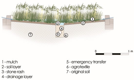
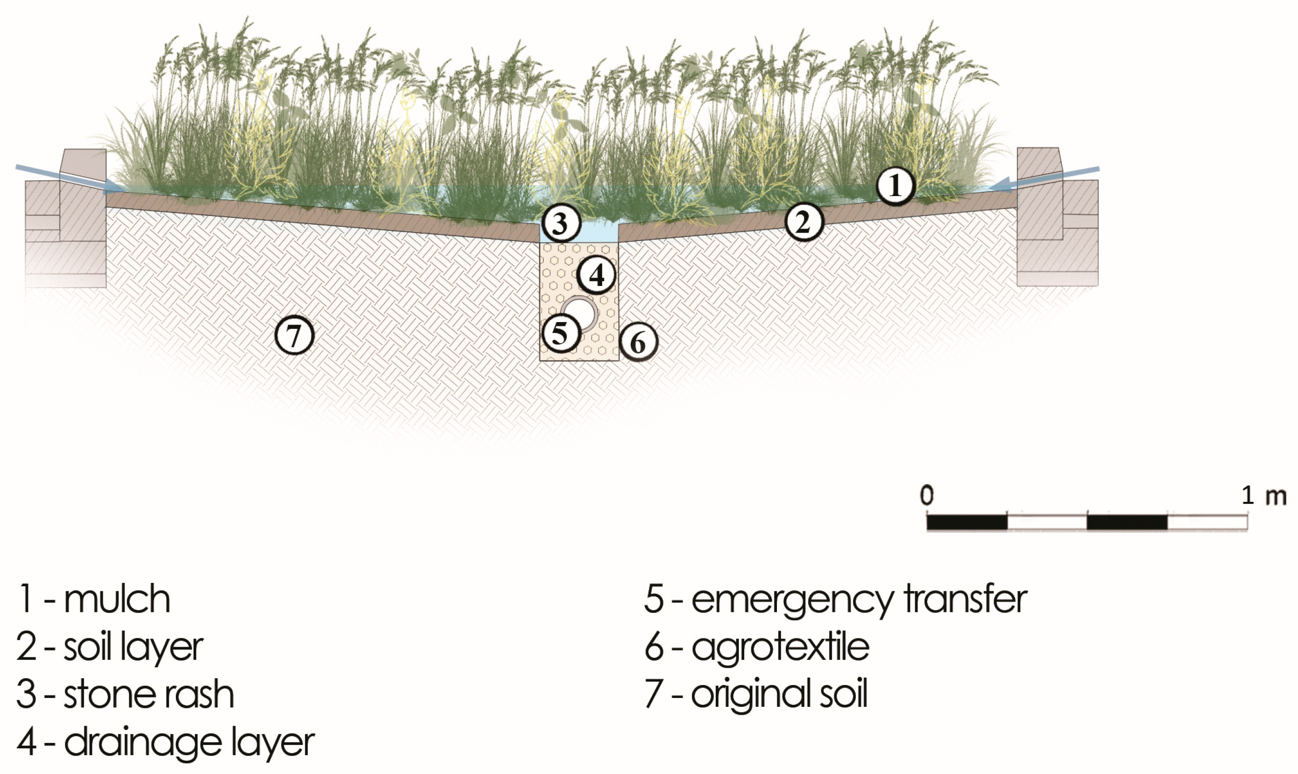
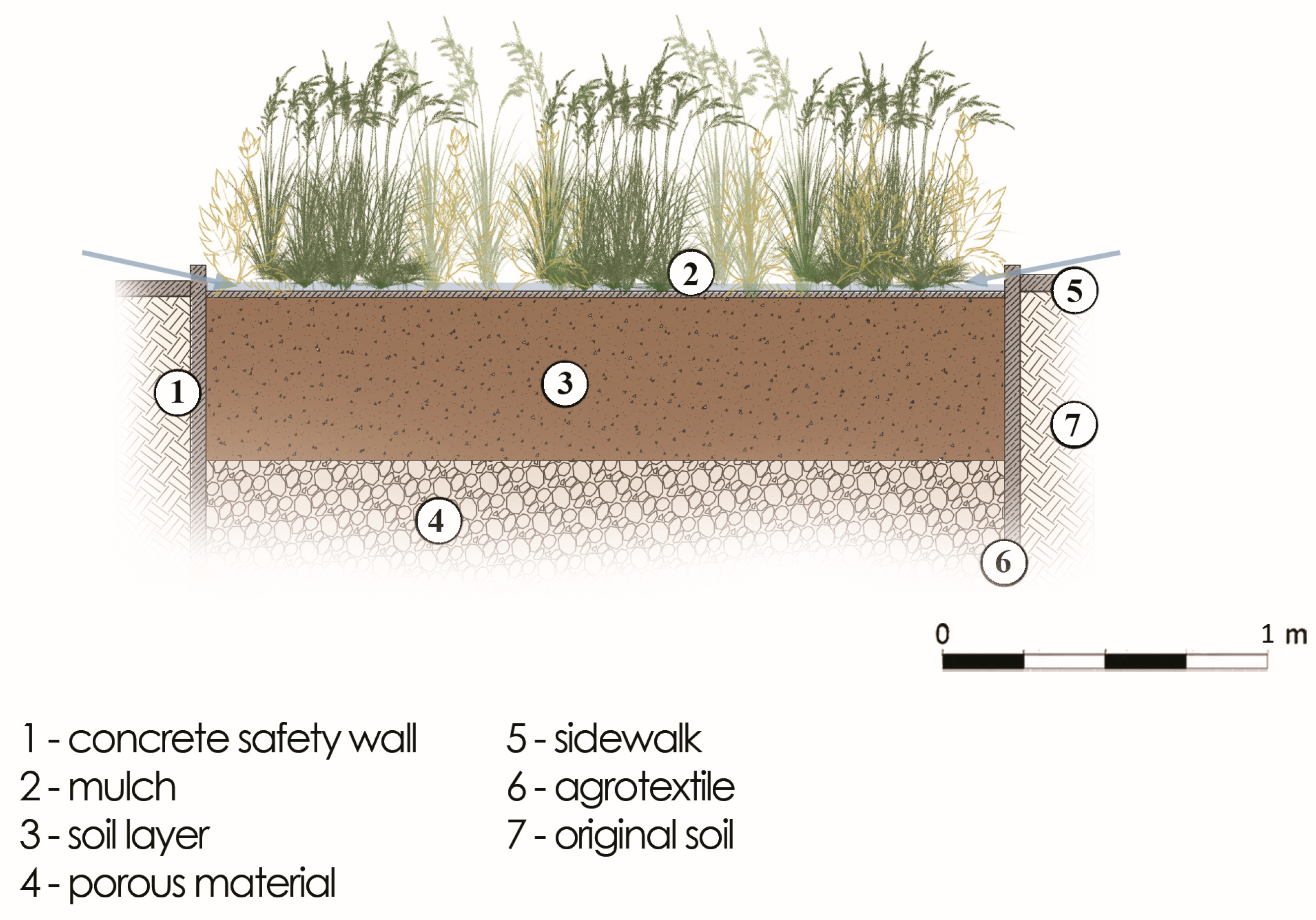
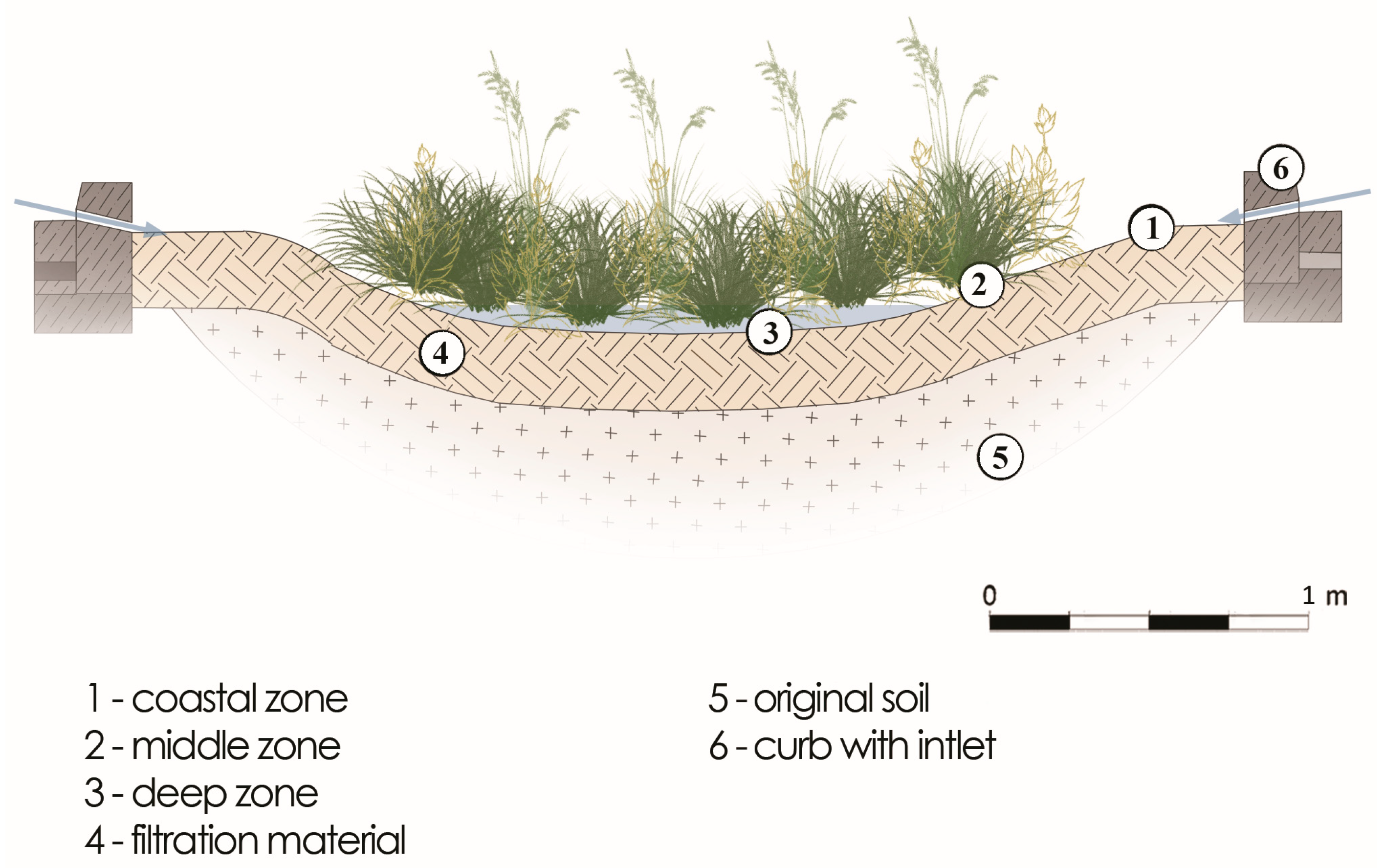
An infiltration swale is a vegetated depression that temporarily stores runoff and supports infiltration and pollutant removal [42]. Its structure typically includes a permeable gravel or crushed-stone layer, a bioretention substrate, and a surface mulch layer (Figure 7) [37,43].
Figure 7.
Structural diagram of an infiltration swale, the blue arrow shows the water inflow (prepared by the authors).
Literature guidance describes swales approximately 1.5–5.0 m wide and 0.3–0.5 m below the surrounding ground level, with gently inclined sides and, where required, drainage and overflow provisions [44,45]. Ponded water should drain within 48 h [37].
2.4.2. Rain Garden
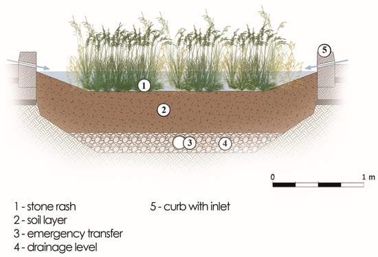
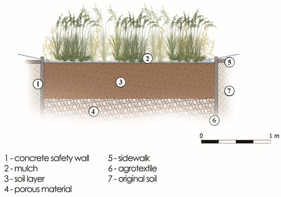
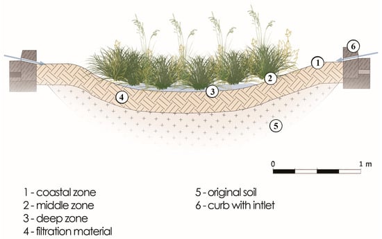
A rain garden collects runoff in a planted depression or constructed basin (Figure 8). Lined and unlined configurations allow adaptation to local soil and groundwater conditions [37,46,47]. Vegetation selection accounts for moisture fluctuations, soil conditions, sunlight exposure, and pollution tolerance [48,49,50]; the screening criteria used in this study are presented in Section 2.5.
Figure 8.
Structural diagram of a rain garden, the blue arrow shows the water inflow (prepared by the authors).
2.4.3. Stormwater Curb Extension
A stormwater curb extension is a kerb-enclosed vegetated facility integrated into the street edge, including locations near crossings, intersections, or public transport stops [51].
Runoff enters through kerb openings or lowered sections and is conveyed to the vegetated bioretention substrate (Figure 9) [52,53]. Facility placement must accommodate pedestrian movement and road geometry [54].
Figure 9.
Structural diagram of a stormwater curb extension, the blue arrow shows the water inflow (prepared by the authors).
Literature guidance gives typical dimensions of 6–12 m in length and 1–3.5 m in width. Depth depends on the planting configuration, reaching approximately 0.5 m for low-growing vegetation and at least 1 m for taller vegetation [45].
Where trees are incorporated, tree-based stormwater filtration may also support bacterial removal [55].
2.4.4. Bioretention Basin
A bioretention basin is a vegetated depression with gently sloping sides and a filter layer that collects and temporarily stores runoff [56]. Planting zones are matched to soil moisture, with inundation-tolerant species in the deepest areas and species adapted to drier conditions along the margins [57]. Ponding should not exceed 48 h.
Literature guidance recommends a facility area not exceeding 5% of the contributing catchment [56] and a minimum separation of 5 m from building walls. These recommendations require site-specific assessment during detailed design.
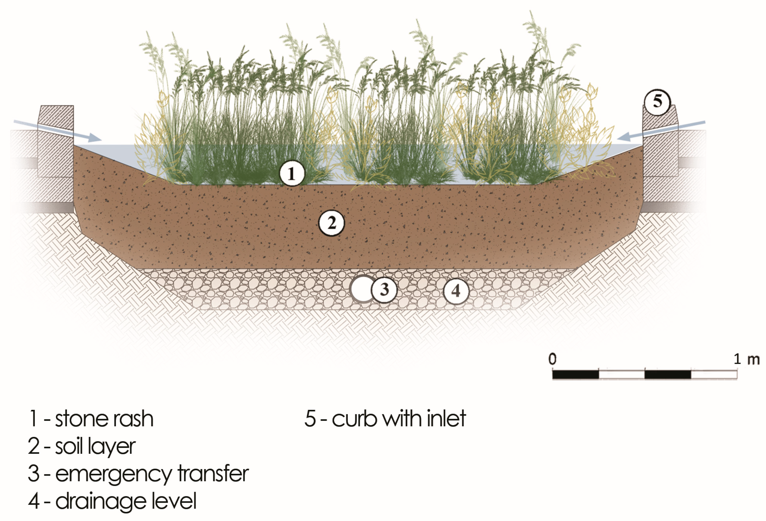
Bioretention basins can be divided into two main types: unlined basins, in which water infiltrates freely into deeper soil layers through the permeable basin fill, and lined basins, which have a more complex structure [58]. The latter typically incorporate a filtration gravel layer, a synthetic liner, and a perforated drainage pipe that conveys excess stormwater generated during intense rainfall to an adjacent inspection chamber [59,60]. Bioretention basins require sufficient space and may use existing topographic depressions [61]. This design enables stormwater retention in locations where low subsoil permeability limits natural infiltration, as may occur in unlined basins (Figure 10).
Figure 10.
Structural diagram of a bioretention basin, the blue arrow shows the water inflow (prepared by the authors).
2.5. Plant Selection Criteria for Roadside BGI
Plant species were screened for climatic adaptation, tolerance to temporary inundation and drought, resistance to de-icing salts and traffic-derived pollutants, root-system persistence, and compatibility with roadside maintenance and visibility requirements (Table 2). Preference was given to native or locally adapted taxa, with planting positions matched to moisture conditions within each facility.
Table 2.
Screening criteria applied for plant selection in roadside blue–green infrastructure.
Vegetation effects on retention, infiltration, evapotranspiration, and pollutant removal were not quantified or included in the design storage calculations.
3. Results
3.1. Conceptual Design
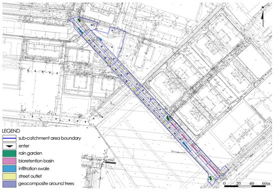
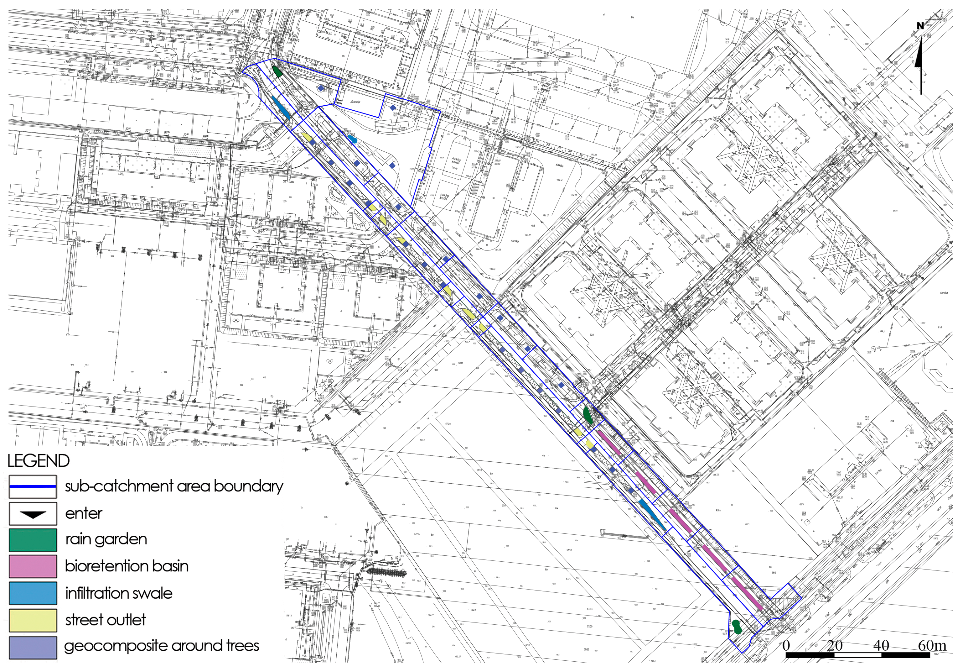
The proposed BGI layout comprises four facility types distributed across 26 sub-catchments (Figure 11). The facilities occupy 581.5 m2: 224.0 m2 of bioretention basins, 161.0 m2 of rain gardens, 153.5 m2 of stormwater curb extensions, and 43.0 m2 of infiltration swales. Two inter-facility overflow connections were proposed, linking sub-catchments 23–24 and 25–26. Residual runoff requires discharge to the existing stormwater drainage system in sub-catchments 18, 22, and 24.
Figure 11.
Diagram of the proposed solutions for the sub-catchments (prepared by the authors).
Shallow vegetated retention basins were proposed where underground infrastructure restricted the use of larger facilities. These basins provide temporary runoff storage with limited interference with existing development.
In the immediate vicinity of car parks and other surfaces with a high degree of sealing, retention extensions were designed at the curbs. Their use allows small fragments of street space to be used to take over runoff, which was particularly important in locations limited by existing infrastructure elements, including hydrants and geodetic signs.
Rain gardens were proposed where space and infrastructure permitted, based on their adopted unit storage capacity and compatibility with the streetscape design.
Unused storage arose where the proposed facility dimensions provided more capacity than required for the adopted design event. This surplus was not introduced as a safety factor and does not establish protection against larger rainfall events.
Water-absorbing geocomposites were proposed in tree root zones to improve moisture availability between rainfall events. Their storage contribution was excluded from the system balance.
Openings in existing kerbs were proposed to convey roadway runoff into adjacent BGI facilities. These inlets provide hydraulic access to storage but do not increase the calculated storage capacity.
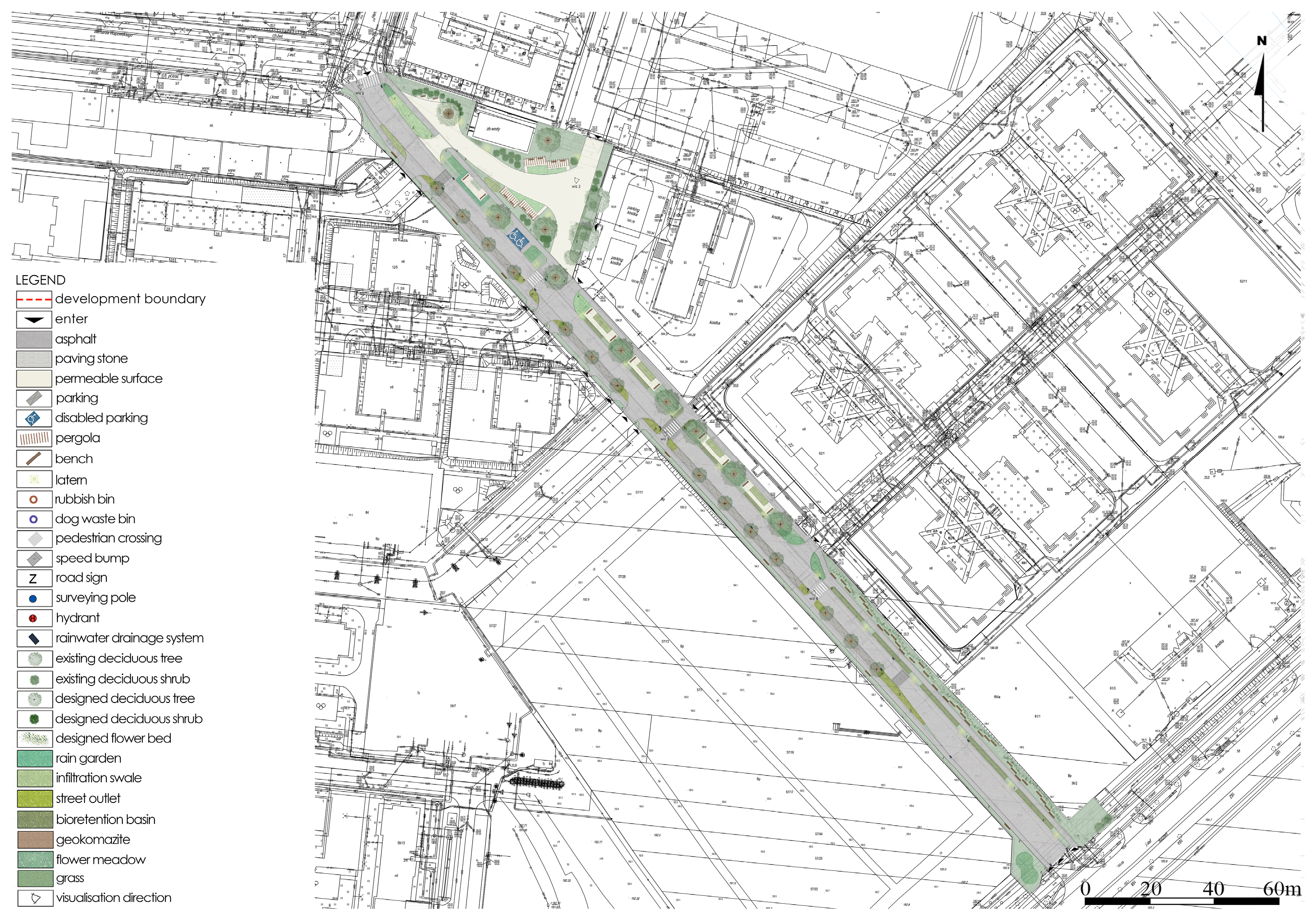
Appendix A presents the conceptual layout of the proposed BGI facilities along Henryka Wolińskiego Street, while the detailed water-balance results for 26 sub-catchments are published in Appendix B.
3.2. Plant Selection for Roadside BGI
The conceptual planting scheme included Bistorta officinalis Delarbre, Echinops ritro L., Iris pseudacorus L., Iris sibirica L., Hemerocallis sp., Lythrum salicaria L., Carex elata All., Juncus effusus L., and Panicum virgatum L. Iris pseudacorus L., Juncus effusus L., Lythrum salicaria L., and Carex elata All. were selected for periodically wet zones. Taxa tolerant of periodic drying were assigned to higher, faster-draining positions.
Table 3 summarizes the literature-based evidence supporting the suitability of the selected taxa and functional groups for roadside BGI [65,66,67]. This evidence informed the conceptual selection but does not constitute a site-specific assessment of plant survival or pollutant removal.
Table 3.
Screening criteria and suitability of selected plant species and functional groups for roadside blue–green infrastructure (BGI) [65,66,67].
3.3. Water Balance
Table 4 summarizes the area and design storage capacity of each BGI type, together with its contribution to accommodated runoff depth over the total study area.
Table 4.
Facility area, design storage capacity, and contribution to accommodated runoff depth by BGI type (prepared by the authors).
The total was calculated using unrounded values; therefore, the sum of the displayed values may differ from the reported total due to rounding. Table 5 summarizes locally generated runoff, sewer discharge, design storage capacity, accommodated runoff, transferred inflow, and unused storage as equivalent depths over the corresponding sub-catchment areas. This normalization enables comparison among sub-catchments of different sizes.
Table 5.
Calculated runoff depths and equivalent storage depths of the proposed BGI system in the analysed sub-catchments (prepared by authors).
The 26 analysed sub-catchments cover 10,339.4 m2. For the adopted design rainfall event, the calculated runoff depth over this area was 7.4 mm. The proposed BGI facilities occupy 581.5 m2 and provide a total design storage capacity equivalent to 6.8 mm over the combined sub-catchment area.
Under the adopted design assumptions, the proposed BGI facilities can accommodate runoff equivalent to 6.6 mm over the total study area, representing 89.4% of the calculated runoff. The remaining 0.8 mm (10.6%) requires discharge to the existing stormwater sewer system. Percentages were calculated before rounding the equivalent depths.
Sewer discharge was required in sub-catchments 18, 22, and 24, with equivalent depths of 7.5, 7.4, and 4.8 mm, respectively, calculated over each corresponding sub-catchment area (Table 5). Together, these discharges correspond to 0.8 mm over the total study area.
Internal transfers from sub-catchments 23 to 24 and 25 to 26 corresponded to inflow depths of 9.7 and 10.6 mm over the respective receiving sub-catchment areas. Total unused design storage was equivalent to 0.2 mm over the entire study area and occurred in different locations from the deficits requiring sewer discharge.
Taken together, the accommodated-runoff share, residual sewer discharge, and 581.5 m2 BGI footprint describe the proposal’s design-level contribution to local stormwater management and its space requirement. The remaining local deficits show why the 89.4% system-wide value should be interpreted alongside the sub-catchment balances when considering the proposal’s sustainability implications.
4. Discussion
The coexistence of unused storage and sewer discharge shows that aggregate design capacity alone is insufficient to assess streetscape runoff management. Capacity must be accessible from runoff-generating areas, but topography and infrastructure can prevent redistribution between facilities. The proposed connections illustrate how hydraulic connectivity can improve the use of distributed storage while leaving some local deficits unresolved. This supports previous findings that BGI should be planned as a spatially connected system [23,24,25].
The highest unit design storage capacity did not correspond to the most extensive spatial application. Although infiltration swales had the highest adopted unit capacity, their placement was constrained by available space and infrastructure. This highlights the need to assess storage parameters together with site geometry and hydraulic access to runoff sources [20,21].
Previous research has examined rain gardens in the context of urban climate adaptation [68], the contribution of rainwater management measures to retention in residential areas [69], and rain garden responses to actual rainfall events [70]. The results also emphasize the importance of considering BGI at the early stages of urban planning and design [71], which is consistent with broader approaches integrating nature-based solutions and ecohydrological principles into the planning of resilient urban structures [6,72,73]. In existing streetscapes, the location of retention facilities and the establishment of hydraulic connections may be constrained by road layouts, parking areas, and underground infrastructure [74,75]. In newly developed or intensively transformed areas, early consideration of stormwater management requirements may enable sufficient space to be reserved for BGI and facilitate the development of more spatially coherent systems.
The hydrological calculations applied in this study are based on established procedures and do not constitute a new hydrological model. The methodological contribution to sustainable stormwater management lies in integrating these calculations with spatial analysis at the sub-catchment scale and the selection of BGI measures under actual streetscape conditions. The resulting balances make local capacity deficits, opportunities for transferring excess runoff, and residual sewer discharge explicit. They also allow planners to examine whether available storage is accessible from runoff-generating surfaces before reserving space for particular facilities. This approach should be distinguished from dynamic modelling of individual BGI facilities [75] and from more complex methods for optimizing the location and spatial configuration of BGI measures [20,24].
From a sustainability perspective, the case study demonstrates how a retention objective can be translated into spatially explicit design requirements and residual drainage needs. The calculated 89.4% runoff accommodation indicates the potential extent of local management for the selected event; it does not establish an equivalent annual reduction in sewer discharge or a reduction in flood peaks. Likewise, temporary storage cannot be equated with groundwater recharge or improved water quality. The framework is therefore most useful as an initial decision-support tool within a broader sustainability assessment, in which hydrological feasibility is evaluated alongside environmental safeguards and long-term resource requirements.
Roadside vegetation must withstand combined hydrological and pollution stresses [62]. Previous studies indicate that de-icing salts can reduce vegetation cover in sensitive taxa [63], while metal accumulation may create a need for biomass management [64]. These findings support screening for long-term persistence and maintenance needs alongside habitat suitability.
Literature on Iris pseudacorus, Juncus effusus, and Lythrum salicaria provides evidence relevant to plant survival and contaminant uptake in wetland and bioretention settings (Table 3) [50,65,66,67]. However, responses depend on exposure and growing conditions and cannot be assumed to represent performance at the study site. Long-term functioning also requires maintenance of substrate permeability, vegetation condition, and inlet and outlet functionality [50].
For the proposed streetscape, a subsequent sustainability assessment should examine whether retention remains functional over time and whether infiltration is compatible with groundwater protection. Monitoring after implementation could pair rainfall and inflow–outflow measurements with observations of drawdown, inlet blockage, substrate condition, and vegetation survival. Where water-quality benefits are claimed, pollutant concentrations and loads would also need to be assessed. Maintenance costs and responsibilities, together with pedestrian accessibility and road safety, should be evaluated before implementation. These are proposed follow-up assessments; the present study did not quantify them.
The results should be interpreted in light of the limitations of the adopted methodology. The reported values are design-level estimates. The analysis does not include dynamic modelling of infiltration, evapotranspiration, antecedent soil moisture, facility drawdown time, or the temporal distribution of rainfall. These parameters may substantially influence the actual performance of bioretention facilities and are considered in more detailed modelling and field-based studies [22,76,77]. Field measurements of soil hydraulic conductivity were also not performed, although soil properties and structure are important determinants of infiltration [19], and no post-implementation monitoring was conducted. The actual performance of the system should therefore be verified during detailed design and subsequently through post-implementation monitoring.
The procedure can support sustainable stormwater planning in other streetscapes, provided that local rainfall, land-cover, soil and groundwater, topographic, and infrastructure data are used. Its transferable component is the planning sequence rather than the numerical parameters adopted for this case study. For municipal application, the same calculation template could be used to compare feasible layouts under a common rainfall assumption and to identify locations requiring detailed investigation. Such comparisons would support transparent planning decisions, but should be supplemented by maintenance responsibilities, life-cycle costs, accessibility requirements, and locally agreed environmental objectives before implementation.
5. Conclusions
The proposed framework supports sustainable urban stormwater management by combining sub-catchment runoff estimates with site constraints to select and preliminarily size streetscape BGI. Its contribution lies in linking spatial requirements with sub-catchment water balances to quantify both the potential for runoff accommodation and the local limitations of decentralized retention. In the Lublin case study, the proposed facilities occupy 581.5 m2, approximately 5.6% of the study area, and provide design storage equivalent to 6.8 mm over the total study area. Under the adopted design event, they could accommodate 89.4% of calculated runoff, with 10.6% requiring sewer discharge. These results quantify a specific water-management dimension of urban sustainability and make the land requirements of the proposed system explicit.
The coexistence of unused storage, equivalent to 0.2 mm over the study area, and local storage deficits demonstrates the importance of locating facilities in relation to runoff sources and providing hydraulic connections where feasible. For sustainable streetscape planning, total design capacity should therefore be considered together with available land and access to that capacity, the spatial distribution of storage, and its hydraulic accessibility. The framework helps identify these constraints and the remaining need for sewer discharge before detailed design.
The results represent design estimates rather than measured operational performance or a comprehensive sustainability assessment. Application elsewhere requires local input data. Field verification of soil hydraulic properties and post-implementation monitoring are needed to assess actual runoff management, while water quality, maintenance, life-cycle costs, and social outcomes require additional evaluation. The framework provides a planning basis for these subsequent assessments without presuming their results.
Author Contributions
Conceptualization, K.B. and M.M.; methodology, K.B.; validation, M.M. and M.D.-P.; supervision, M.M. and M.D.-P.; writing—original draft preparation, K.B. and M.M.; writing—review and editing, K.B., M.M. and M.D.-P. All authors have read and agreed to the published version of the manuscript.
Funding
The research was funded by University of Life Sciences in Lublin under the IDUB University Development Strategy for 2024–2026, from funds allocated to the discipline of Agriculture and Horticulture.
Institutional Review Board Statement
Not applicable.
Informed Consent Statement
Not applicable.
Data Availability Statement
The original contributions presented in this study are included in the article. Further inquiries can be directed to the corresponding authors.
Conflicts of Interest
The authors declare no conflicts of interest.
Appendix A
Figure A1.
Top view of the conceptual design for the area along Henryka Wolińskiego Street (prepared by the authors).
Appendix B
Table A1.
Stormwater management in the sub-catchment I * (prepared by Katarzyna Bernat).
Table A2.
Stormwater management in the sub-catchment II * (prepared by Katarzyna Bernat).
Table A3.
Stormwater management in the sub-catchment III * (prepared by Katarzyna Bernat).
Table A4.
Stormwater management in the sub-catchment IV * (prepared by Katarzyna Bernat).
Table A5.
Stormwater management in the sub-catchment V * (prepared by Katarzyna Bernat).
Table A6.
Stormwater management in the sub-catchment VI * (prepared by Katarzyna Bernat).
Table A7.
Stormwater management in the sub-catchment VII * (prepared by Katarzyna Bernat).
Table A8.
Stormwater management in the sub-catchment VIII * (prepared by Katarzyna Bernat).
Table A9.
Stormwater management in the sub-catchment IX * (prepared by Katarzyna Bernat).
Table A10.
Stormwater management in the sub-catchment X * (prepared by Katarzyna Bernat).
Table A11.
Stormwater management in the sub-catchment XI * (prepared by Katarzyna Bernat).
Table A12.
Stormwater management in the sub-catchment XII * (prepared by Katarzyna Bernat).
Table A13.
Stormwater management in the sub-catchment XIII * (prepared by Katarzyna Bernat).
Table A14.
Stormwater management in the sub-catchment XIV * (prepared by Katarzyna Bernat).
Table A15.
Stormwater management in the sub-catchment XV * (prepared by Katarzyna Bernat).
Table A16.
Stormwater management in the sub-catchment XVI * (prepared by Katarzyna Bernat).
Table A17.
Stormwater management in the sub-catchment XVII * (prepared by Katarzyna Bernat).
Table A18.
Stormwater management in the sub-catchment XVIII * (prepared by Katarzyna Bernat).
Table A19.
Stormwater management in the sub-catchment XIX * (prepared by Katarzyna Bernat).
Table A20.
Stormwater management in the sub-catchment XX * (prepared by Katarzyna Bernat).
Table A21.
Stormwater management in the sub-catchment XXI * (prepared by Katarzyna Bernat).
Table A22.
Stormwater management in the sub-catchment XXII * (prepared by Katarzyna Bernat).
Table A23.
Stormwater management in the sub-catchment XXIII * (prepared by Katarzyna Bernat).
Table A24.
Stormwater management in the sub-catchment XXIV * (prepared by Katarzyna Bernat).
Table A25.
Stormwater management in the sub-catchment XXV * (prepared by Katarzyna Bernat).
Table A26.
Stormwater management in the sub-catchment XXVI * (prepared by Katarzyna Bernat).
References
- Archana, T.R.; Vinod, D.; Mahesha, A. Decadal Trends and Climatic Influences on Flash Droughts and Flash Floods in Indian Cities. Urban Clim. 2024, 58, 102143. [Google Scholar] [CrossRef] [Scilit]
- Dąbrowska, J.; Menéndez Orellana, A.E.; Kilian, W.; Moryl, A.; Cielecka, N.; Michałowska, K.; Policht-Latawiec, A.; Michalski, A.; Bednarek, A.; Włóka, A. Between Flood and Drought: How Cities Are Facing Water Surplus and Scarcity. J. Environ. Manag. 2023, 345, 118557. [Google Scholar] [CrossRef] [Scilit] [PubMed]
- Stec, A.; Dziopak, J. Rainwater in the landscape architecture of modern cities. J. Civ. Eng. Environ. Archit. 2017, 64, 315–333. [Google Scholar] [CrossRef] [Scilit]
- Grigg, N.S. Stormwater Management: An Integrated Approach to Support Healthy, Livable, and Ecological Cities. Urban Sci. 2024, 8, 89. [Google Scholar] [CrossRef] [Scilit]
- Aghaloo, K.; Sharifi, A.; Habibzadeh, N.; Ali, T.; Chiu, Y.-R. How Nature-Based Solutions Can Enhance Urban Resilience to Flooding and Climate Change and Provide Other Co-Benefits: A Systematic Review and Taxonomy. Urban For. Urban Green. 2024, 95, 128320. [Google Scholar] [CrossRef] [Scilit]
- Frantzeskaki, N.; McPhearson, T.; Collier, M.J.; Kendal, D.; Bulkeley, H.; Dumitru, A.; Walsh, C.; Noble, K.; van Wyk, E.; Ordóñez, C.; et al. Nature-Based Solutions for Urban Climate Change Adaptation: Linking Science, Policy, and Practice Communities for Evidence-Based Decision-Making. BioScience 2019, 69, 455–466. [Google Scholar] [CrossRef] [Scilit]
- Czerniakowski, Z.W.; Gargała-Polar, M. Rain gardens as a way to retard rainwater losses in urban green areas. Pol. J. Sustain. Dev. 2020, 24, 17–24. [Google Scholar] [CrossRef] [Scilit]
- Khanal, G.; Maraseni, T.; Thapa, A.; Devkota, N.; Paudel, U.R.; Khanal, C.K. Managing Water Scarcity via Rainwater Harvesting System in Kathmandu Valley, Nepal: People’s Awareness, Implementation Challenges and Way Forward. Environ. Dev. 2023, 46, 100850. [Google Scholar] [CrossRef] [Scilit]
- Ali, S.; Sang, Y.-F.; Pilla, F.; Singh, V.P.; Dilawar, A. Implementing Urban Rainwater Harvesting Systems: Multiple Potential Performances, Barriers, Challenges, Solutions, and Future Perspectives. Renew. Sustain. Energy Rev. 2025, 218, 115793. [Google Scholar] [CrossRef] [Scilit]
- Wu, X.; Moustakas, S.; Bezak, N.; Radinja, M.; Alivio, M.B.; Mikoš, M.; Dohnal, M.; Bares, V.; Willems, P. Assessing the Performance of Blue-Green Solutions through a Fine-Scale Water Balance Model for an Urban Area. Sci. Total Environ. 2024, 948, 174750. [Google Scholar] [CrossRef] [Scilit] [PubMed]
- Chaves, M.T.R.; Farias, T.R.L.; Eloi, W.M. Comparative Analysis of Bioretention Design Strategies for Urban Runoff Infiltration: A Critical Overview. Ecol. Eng. 2024, 207, 107352. [Google Scholar] [CrossRef] [Scilit]
- Oral, H.V.; Carvalho, P.; Gajewska, M.; Ursino, N.; Masi, F.; Hullebusch, E.D.; Kazak, J.K.; Exposito, A.; Cipolletta, G.; Andersen, T.R.; et al. A Review of Nature-Based Solutions for Urban Water Management in European Circular Cities: A Critical Assessment Based on Case Studies and Literature. Blue-Green Syst. 2020, 2, 112–136. [Google Scholar] [CrossRef] [Scilit]
- Jnawali, S.S.; McBroom, M.; Zhang, Y.; Stafford, K.; Wang, Z.; Creech, D.; Cheng, Z. Effectiveness of Rain Gardens for Managing Non-Point Source Pollution from Urban Surface Storm Water Runoff in Eastern Texas, USA. Sustainability 2025, 17, 4631. [Google Scholar] [CrossRef] [Scilit]
- Bonciarelli, L.; Orlandi, F.; Muscas, D.; Fornaciari, M. Zrównoważone zarządzanie wodami opadowymi i bioretencja: Przegląd przeglądów z ostatnich 10 lat. Land 2025, 14, 736. [Google Scholar] [CrossRef] [Scilit]
- Vigneswaran, S.; Kandasamy, J.; Ratnaweera, H. Wysokowydajne oczyszczanie wód opadowych w celu ponownego wykorzystania i oszczędzania wody—przegląd. Appl. Sci. 2025, 15, 590. [Google Scholar] [CrossRef] [Scilit]
- Godyń, I.; Grela, A.; Muszyński, K.; Pamuła, J. Wpływ zielonej infrastruktury na jakość wód opadowych i ryzyko środowiskowe. Zrównoważony Rozw. 2024, 16, 8530. [Google Scholar] [CrossRef] [Scilit]
- Rehan, R.M. Sustainable streetscape as an effective tool in sustainable urban design. HBRC J. 2013, 9, 173–186. [Google Scholar] [CrossRef] [Scilit]
- Jeleński, T.; Kosiński, W. How to Transform a Place: A Guide to Creating Successful Public Spaces; Partnership for the Environment Foundation: Kraków, Poland, 2009. [Google Scholar]
- Basset, C.; Abou Najm, M.R.; Ghezzehei, T.A.; Hao, X.; Daccache, A. How Does Soil Structure Affect Water Infiltration? A Meta-Data Systematic Review. Soil Tillage Res. 2023, 226, 105577. [Google Scholar] [CrossRef] [Scilit]
- Gulshad, K.; Szydłowski, M.; Yaseen, A.; Aslam, R.W. A Comparative Analysis of Methods and Tools for Low Impact Development (LID) Site Selection. J. Environ. Manag. 2024, 354, 120212. [Google Scholar] [CrossRef] [Scilit] [PubMed]
- California Department of Transportation. Bioretention Treatment Best Management Practice Design Guide; California Department of Transportation: Sacramento, CA, USA, 2021. Available online: https://dot.ca.gov/-/media/dot-media/programs/design/documents/3_dg-bioretention_ada.pdf (accessed on 13 July 2026).
- Sagrelius, P.Ö.; Blecken, G.; Hedström, A.; Ashley, R.; Viklander, M. Sustainability Performance of Bioretention Systems with Various Designs. J. Environ. Manag. 2023, 340, 117949. [Google Scholar] [CrossRef] [Scilit] [PubMed]
- Jazayeri Moghanlo, S.; Raimondi, A. Impacts of Blue-Green Infrastructures on Combined Sewer Overflows. Nat.-Based Solut. 2025, 7, 100208. [Google Scholar] [CrossRef] [Scilit]
- Iliadis, C.; Glenis, V.; Kilsby, C. A Cost-Benefit ‘Source-Receptor’ Framework for Implementation of Blue-Green Flood Risk Management. J. Hydrol. 2024, 634, 131113. [Google Scholar] [CrossRef] [Scilit]
- Shuster, W.D.; Darner, R.A.; Schifman, L.A.; Herrmann, D.L. Factors Contributing to the Hydrologic Effectiveness of a Rain Garden Network (Cincinnati, Ohio). Infrastructures 2017, 2, 11. [Google Scholar] [CrossRef] [Scilit] [PubMed]
- Available online: https://mapy.geoportal.gov.pl/ (accessed on 5 March 2024).
- The ‘Brama Grodzka—Teatr NN’ Centre. Lublin’s Wrotków District. A Lexicon of Teatr NN. Available online: https://teatrnn.pl/leksykon/artykuly/dzielnice-lublina-wrotkow/ (accessed on 24 November 2025).
- Plan for the Wrotków District; Office for Public Participation, Lublin City Council: Lublin, Poland, 2025; Available online: https://lublin.eu/download/gfx/lublin/userfiles/_public/mieszkancy/partycypacja/plan_dla_dzielnic/27_dokumentow/wrotkow_plan_dla_dzielnic.pdf (accessed on 24 November 2025).
- Gawarecki, H.; Gawdzik, C. Through the Streets of Lublin: A Guide; Lubelskie Publishing House: Lublin, Poland, 1976. [Google Scholar]
- Lublin City Council. Study of Conditions and Directions for Spatial Development of the City of Lublin; Resolution No. 283/VIII/2019 of the Lublin City Council dated 1 July 2019; Lublin City Council: Lublin, Poland, 2019; Available online: https://bip.lublin.eu/strategia-i-planowanie/planowanie-przestrzenne/studium-uwarunkowan-i-kierunkow-zagospodarowania-przestrzennego-miasta-lublin/ (accessed on 24 November 2025).
- Pietruszka, W.; Szczerbicka, M.; Zezula, H. Explanatory Notes to the Hydrogeological Map of Poland at a scale of 1:50,000. Lublin Sheet (749); Polish Geological Institute: Warsaw, Poland, 2002. [Google Scholar]
- Heliasz, Z.; Ostaficzuk, S.; Bojakowska, I.; Kwecko, P.; Miecznik, J.; Wojciechowska, K. Explanatory Notes to the Geo-Environmental Map of Poland at a Scale of 1:50,000. Lublin Sheet (749); Polish Geological Institute: Warsaw, Poland, 2011. Available online: https://bazadata.pgi.gov.pl/data/mgsp/txt/mgsp0749.pdf (accessed on 12 December 2025).
- United States Department of Agriculture, Natural Resources Conservation Service. National Engineering Handbook, Part 630—Hydrology, Chapter 7: Hydrologic Soil Groups; USDA-NRCS: Washington, DC, USA, 2009. Available online: https://directives.nrcs.usda.gov/sites/default/files2/1712930597/11905.pdf (accessed on 12 December 2025).
- Michalczyk, Z. (Ed.) An Assessment of Water Occurrence Conditions and the Formation of Surface Runoff in Lublin. In Hydrographic Studies in Environmental Science; Maria Curie-Skłodowska University Press: Lublin, Poland, 2012; Volume 10. [Google Scholar]
- Michalczyk, Z.; Chmiel, S.; Głowacki, S.; Sposób, J. Exploitation of groundwater resources in Lublin between 1955 and 2015. Geol. Rev. 2017, 65, 1350–1355. [Google Scholar]
- Polish Geological Institute—National Research Institute. Hydrogeological Map of Poland at a Scale of 1:50,000—First Aquifer, Occurrence and Hydrodynamics. Lublin Sheet (749); Polish Geological Institute—National Research Institute: Warsaw, Poland, 2006. Available online: https://www.pgi.gov.pl/psh/psh-2/kartografia-hydrogeologiczna.html (accessed on 13 February 2026).
- Lejcuś, K.; Burszta-Adamiak, E.; Dąbrowska, J.; Wróblewska, K.; Orzeszyna, H.; Śpitalniak, M.; Misiewicz, J. Catalogue of Good Practices—Principles for the Sustainable Management of Stormwater Runoff from Road Surfaces; Wrocław University of Environmental and Life Sciences Press: Wrocław, Poland, 2021. [Google Scholar]
- Geiger, W.; Dreiseitl, H. New Methods of Rainwater Drainage. A Guide; Publishing House PROJPRZEM EKO: Bydgoszcz, Poland, 1999. [Google Scholar]
- Słyś, D. Rainwater Retention and Infiltration; Publishing House of the Rzeszów University of Technology: Rzeszów, Poland, 2008. [Google Scholar]
- Ozga-Zieliński, B. (Ed.) Modele Probabilistyczne Opadów Maksymalnych o Określonym Czasie Trwania i Prawdopodobieństwie Przewyższenia—Projekt PMAXTP; Instytut Meteorologii i Gospodarki Wodnej—Państwowy Instytut Badawczy: Warszawa, Poland, 2022. [Google Scholar]
- Available online: https://klimat.imgw.pl/opady-maksymalne/ (accessed on 23 August 2026).
- The City of Bielsko-Biała. Retention. Catalogue of Good Practices for Project Contractors; Bielsko-Biała City Council: Bielsko-Biała, Poland, 2025; Available online: https://bielsko-biala.pl/sites/default/files/2025-06/retencja-katalog-dobrych-praktyk.pdf (accessed on 13 February 2026).
- SAFEGE S.A.S. Polish Branch. Green Rainwater Infrastructure—Its Significance in Water Management. DachyPortal.pl. 2025. Available online: http://dachyportal.pl/zielona-infrastruktura-deszczowa-istotne-znaczenie-w-gospodarce-wodnej/ (accessed on 24 March 2026).
- Bogacz, A.; Woźniczka, P.; Burszta-Adamiak, E.; Kolasińska, K. Methods of enhancing water retention in urban areas. Sci. Rev. Eng. Environ. Des. 2013, 22, 27–35. [Google Scholar]
- Iwaszuk, E.; Rudik, G.; Duin, L.; Mederake, L.; Davis, M.; Naumann, S.; Wagner, I. Błękitno-Zielona Infrastruktura dla Łagodzenia Zmian Klimatu w Miastach—Katalog Techniczny; Bergier, T., Kowalewska, A., Eds.; Ecologic Institute, Fundacja Sendzimira: Berlin, Germany; Kraków, Poland, 2019; Available online: https://sendzimir.org.pl/wp-content/uploads/2020/03/Blekitno-zielona-infrastruktura_dla_lagodzenia_zmian_klimatu-poradnik_techniczny.pdf (accessed on 24 May 2026).
- Rayss, J. Urban Green Infrastructure and Rainwater: The Potential for Sustainable Development in Gdańsk; Gdańsk University of Technology Press: Gdańsk, Poland, 2017. [Google Scholar]
- Donaghue, A.G.; Morgan, N.; Toran, L.; McKenzie, E.R. The Impact of Bioretention Column Internal Water Storage Underdrain Height on Denitrification under Continuous and Transient Flow. Water Res. 2022, 214, 118205. [Google Scholar] [CrossRef] [Scilit] [PubMed]
- Johnston, M.R.; Balster, N.J.; Thompson, A.M. Vegetation Alters Soil Water Drainage and Retention of Replicate Rain Gardens. Water 2020, 12, 3151. [Google Scholar] [CrossRef] [Scilit]
- Suchocka, M.; Siedlecka, M. Vegetation as an important element of the urban stormwater management system. Road Eng. 2017, 7–8, 236–243. [Google Scholar]
- Laukli, K.; Gamborg, M.; Haraldsen, T.K.; Vike, E. Soil and Plant Selection for Rain Gardens along Streets and Roads in Cold Climates: Simulated Cyclic Flooding and Real-Scale Studies of Five Herbaceous Perennial Species. Urban For. Urban Green. 2022, 68, 127477. [Google Scholar] [CrossRef] [Scilit]
- Aquanet Retencja Sp. z o.o. Aquanet Retention Catalogue. Part III—Rainwater Management Methods for Transport Infrastructure; Aquanet Retention Sp. z o.o.: Poznań, Poland, 2022; Available online: https://www.aquanet-retencja.pl/wp-content/uploads/2023/03/AQR_KATALOG-III.pdf (accessed on 15 April 2026).
- United States Environmental Protection Agency. Green Streets Handbook; EPA 841-B-18-001; U.S. Environmental Protection Agency: Washington, DC, USA, 2021. Available online: https://nepis.epa.gov/Exe/ZyPURL.cgi?Dockey=P1012A44.TXT (accessed on 15 April 2026).
- Rodriguez-Valencia, A.; Ortiz-Ramirez, H.A. Understanding Green Street Design: Evidence from Three Cases in the U.S. Sustainability 2021, 13, 1916. [Google Scholar] [CrossRef] [Scilit]
- Li, X.; Wang, C.; Chen, G.; Wang, Q.; Hu, Z.; Wu, J.; Wang, S.; Fang, X. Performance Analysis for Road-Bioretention with Three Types of Curb Inlet Using Numerical Model. Water 2021, 13, 1643. [Google Scholar] [CrossRef] [Scilit]
- Schifman, L.A.; Kasaraneni, V.K.; Sullivan, R.K.; Oyanedel-Craver, V.; Boving, T.B. Bacteria Removal from Stormwater Runoff Using Tree Filters: A Comparison of a Conventional and an Innovative System. Water 2016, 8, 76. [Google Scholar] [CrossRef] [Scilit]
- de la Colina, M.A.F.; Gracia, P.I.; Gawryluk, D. Urban Public Spaces: Madrid, Bialystok, Klaipeda: A Guide to Their Functions and Meaning; Economy and Environment Publishing House: Madrid, Spain, 2022. [Google Scholar]
- Dagenais, D.; Brisson, J.; Fletcher, T.D. The Role of Plants in Bioretention Systems: Does the Science Underpin Current Guidance? Ecol. Eng. 2018, 120, 532–545. [Google Scholar] [CrossRef] [Scilit]
- Al Amin, M.B.; Sujono, J.; Triatmadja, R. Hydrological Performance and Design of Bioretention Systems for Heavy Rainfall Management: A Laboratory Study. Nat.-Based Solut. 2025, 7, 100265. [Google Scholar] [CrossRef] [Scilit]
- Lisenbee, W.A.; Hathaway, J.M.; Burns, M.J.; Fletcher, T.D. Analysis of the Hydrologic Performance in a Lined Bioretention Basin and Implications for Monitoring and Design. J. Sustain. Water Built Environ. 2025, 11, 05024004. [Google Scholar] [CrossRef] [Scilit]
- Nazarpour, S.; Gnecco, I.; Palla, A. Evaluating the Effectiveness of Bioretention Cells for Urban Stormwater Management: A Systematic Review. Water 2023, 15, 913. [Google Scholar] [CrossRef] [Scilit]
- Chen, H.; Wu, W.; Li, C.; Lu, G.; Ye, D.; Ma, C.; Ren, L.; Li, G. Ecological and environmental effects of global photovoltaic power plants: A meta-analysis. J. Environ. Manag. 2025, 373, 123785. [Google Scholar] [CrossRef] [Scilit] [PubMed]
- Khaniya, B.; Szota, C.; Fletcher, T.D.; Drake, J. Road salt reduces plant cover in bioretention systems within road rights-of-way. Sci. Total Environ. 2025, 995, 180082. [Google Scholar] [CrossRef] [Scilit] [PubMed]
- Khaniya, B.; Szota, C.; Fletcher, T.D.; Drake, J. Road salt induced mobilization and accumulation of heavy metals in roadside bioretention in the field: The roles of season, plant uptake, media, and catchment properties. Chemosphere 2026, 405, 144958. [Google Scholar] [CrossRef] [Scilit] [PubMed]
- Lange, K.; Viklander, M.; Blecken, G.-T. Effects of plant species and traits on metal treatment and phytoextraction in stormwater bioretention. J. Environ. Manag. 2020, 276, 111282. [Google Scholar] [CrossRef] [Scilit] [PubMed]
- Laukli, K.; Gamborg, M.; Haraldsen, T.K.; Vike, E. Plant Selection for Roadside Rain Gardens in Cold Climates Using Real-Scale Studies of Thirty-One Herbaceous Perennials. Urban For. Urban Green. 2022, 78, 127759. [Google Scholar] [CrossRef] [Scilit]
- Mohsin, M.; Nawrot, N.; Wojciechowska, E.; Kuittinen, S.; Szczepańska, K.; Dembska, G.; Pappinen, A. Cadmium Accumulation by Phragmites australis and Iris pseudacorus from Stormwater in Floating Treatment Wetlands Microcosms: Insights into Plant Tolerance and Utility for Phytoremediation. J. Environ. Manag. 2023, 331, 117339. [Google Scholar] [CrossRef] [Scilit] [PubMed]
- Johansson, G.; Karlfeldt Fedje, K.; Modin, O.; Haeger-Eugensson, M.; Uhl, W.; Andersson-Sköld, Y.; Strömvall, A.-M. Removal and Release of Microplastics and Other Environmental Pollutants during the Start-up of Bioretention Filters Treating Stormwater. J. Hazard. Mater. 2024, 468, 133532. [Google Scholar] [CrossRef] [Scilit] [PubMed]
- Bąk, J.; Barjenbruch, M. Benefits, Inconveniences, and Facilities of the Application of Rain Gardens in Urban Spaces from the Perspective of Climate Change—A Review. Water 2022, 14, 1153. [Google Scholar] [CrossRef] [Scilit]
- Gama Marques, P. The impact of rainwater management measures on the retention capacity of residential areas. Builder 2022, 299, 37–41. [Google Scholar] [CrossRef] [Scilit]
- Burszta-Adamiak, E.; Biniak-Pieróg, M.; Dąbek, P.B.; Sternik, A. Rain garden hydrological performance–Responses to real rainfall events. Sci. Total Environ. 2023, 887, 164153. [Google Scholar] [CrossRef] [Scilit] [PubMed]
- Raffa, A. Design Urban Climate-Resilience with Nature-Based Solutions and Green Infrastructures. Challenges, Issues, and Best Practices for Neighborhood-Scale Regeneration. Anu. d’Arquit. Soc. 2023, 3, 234–266. [Google Scholar] [CrossRef] [Scilit]
- Wagner, I.; Breil, P. The Role of Ecohydrology in Creating More Resilient Cities. Ecohydrol. Hydrobiol. 2013, 13, 113–134. [Google Scholar] [CrossRef] [Scilit]
- Wagner, I.; Zalewski, M. Ecohydrology as a Basis for the Sustainable City Strategic Planning: Focus on Lodz, Poland. Rev. Environ. Sci. Biotechnol. 2009, 8, 209–217. [Google Scholar] [CrossRef] [Scilit]
- Wu, Z.; Li, S.; Liu, Y.; Mattoon, E.C.; Al-Farsi, M.Z.; Her, Y.; Chen, J.; Feng, X.; Jaber, F.H. Improvement of Simulating Rain Gardens to Advance Sustainable Stormwater Management. J. Environ. Manag. 2026, 401, 128853. [Google Scholar] [CrossRef] [Scilit] [PubMed]
- Ardren, R.; Davies, P.J. Exploring links between ownership, governance and condition of stormwater quality improvement devices. J. Environ. Plan. Manag. 2022, 66, 1675–1693. [Google Scholar] [CrossRef] [Scilit]
- Chen, Y.-C.; Tsai, Y.-P.; Chang, N.-B.; Chao, Y.-L.; Lee, T.-Y.; Chen, C.-F. Field Performance of 15 Rain Gardens in Different Cities in Taiwan. Sci. Total Environ. 2024, 947, 174545. [Google Scholar] [CrossRef] [Scilit] [PubMed]
- Pancewicz, A. Urban Nature as an Active Means of Adapting Public Spaces to Climate Conditions: Case Studies from Copenhagen and Selected Polish Cities. Civ. Environ. Eng. Rep. 2022, 32, 123–146. [Google Scholar] [CrossRef] [Scilit]

Disclaimer/Publisher’s Note: The statements, opinions and data contained in all publications are solely those of the individual author(s) and contributor(s) and not of MDPI and/or the editor(s). MDPI and/or the editor(s) disclaim responsibility for any injury to people or property resulting from any ideas, methods, instructions or products referred to in the content. |
© 2026 by the authors. Licensee MDPI, Basel, Switzerland. This article is an open access article distributed under the terms and conditions of the Creative Commons Attribution (CC BY) license.