


Abstract
Immersive technologies support heritage interpretation and management, yet research remains divided between cultural and archaeological heritage and urban planning. This systematic review, reported according to PRISMA 2020, aimed to examine the design, application, and evaluation of augmented, virtual, and mixed reality systems in archaeological parks, historic districts, and urban-planning contexts. Peer-reviewed English-language journal articles and full conference papers published from 2010 to 15 July 2026 were eligible; museum-only, artifact-only, non-immersive, and methodologically insufficient reports were excluded. Scopus, Web of Science Core Collection, IEEE Xplore, ACM Digital Library, and SpringerLink were searched through 15 July 2026. A five-domain, study-type-adapted rubric was used for critical appraisal, and findings were synthesized narratively by spatial scale, delivery mode, technology pipeline, and evaluation. Of 10,790 records, 21 studies were included: 17 direct applications, three enabling methods, and one foundational survey. Twelve reported user or stakeholder evaluations, but only ten reported numerical sample sizes, precluding calculation of a pooled participant total. Evidence was heterogeneous, predominantly descriptive, and rarely longitudinal. The original screening, data extraction, and critical appraisal were performed by a single reviewer. Following peer review, all 21 included reports and the key coding and appraisal variables underwent retrospective independent verification and reconciliation. No supplementary hand-searching or citation searching was conducted. The urban dimension of ancient cities remains underexplored, while communication of uncertainty in city-scale reconstructions remains unresolved. The review proposes a cross-domain taxonomy, core evaluation outcomes, and an integrated research agenda. No external funding was received. The review was not registered, and no formal protocol was prepared.
1. Introduction
1.1. Background and Motivation
Archaeological parks hold a distinctive position within the realm of cultural heritage. While museums often decontextualize artefacts and individual monuments can be perceived within a single visual field, archaeological parks encourage visitors to interpret a city, or a substantial portion of it, through its material remains. Notable sites such as Pompeii, Herculaneum, Ostia Antica, Paestum, and Ephesus preserve both architectural structures and urban systems, including street grids and their hierarchies, insulae and their internal subdivisions, the organization of fora, sanctuaries, theatres, domestic quarters, and the infrastructural networks that connect them. The interpretive challenge presented by these sites is fundamentally urban and inherently multi-scalar. Understanding a single domus requires situating it within its block. Comprehending the block necessitates an understanding of the street network, and grasping the network demands an appreciation of the city and its broader territory [1].
Extended reality (XR) technologies—augmented reality (AR), virtual reality (VR), and mixed reality (MR)—support the kind of spatially situated multi-scalar mediation this challenge demands [2,3]. On-site AR can overlay the reconstructed elevation on the surviving foundation; off-site VR can restore the experience of walking a street that no longer stands. Digital twins can bind survey data, reconstructions, simulations, and management information into a single navigable model [4,5,6]. Three decades of research, from the pioneering virtual reconstructions of the 1990s to the current generation of WebXR platforms, national valorization programs, and neural rendering pipelines, testify to a sustained conviction that immersive media are a natural language for the communication of ancient built environments [7,8,9,10].
Yet the research addressing this conviction is split between two communities that publish in different venues, cite different canons, and evaluate their systems by different standards. The first is the cultural heritage community, whose XR literature is anchored in journals and venues such as the ACM Journal on Computing and Cultural Heritage, Digital Applications in Archaeology and Cultural Heritage, Virtual Archaeology Review, and the CAA and GCH conference series, and whose central concerns are reconstruction fidelity, scientific transparency, storytelling, and visitor experience [11,12]. The second is the urban informatics and planning community, publishing in venues oriented to visualization, geo-information science, and smart cities, whose concerns are navigation and wayfinding at the city scale, multi-scale visualization, collaborative and participatory design, digital twins, and decision support [13]. The two communities confront the same fundamental problem—how humans perceive, navigate, and reason about extended urban environments through immersive media—but their results rarely cross the disciplinary boundary. The navigation techniques developed and rigorously evaluated for virtual New York or Tokyo are, with few exceptions, absent from virtual Pompeii. Conversely, the heritage community’s two decades of reflection on reconstructive uncertainty and interpretive transparency find no echo in the urban digital twin literature, where the model is tacitly assumed to be a faithful mirror of the present [4].
1.2. Related Reviews and the Research Gap
A substantial body of the secondary literature covers portions of this territory. A foundational survey of AR, VR, and MR for cultural heritage organized the field by technology, immersion level, and application purpose (education, exhibition enhancement, exploration, reconstruction, virtual museums); it remains the standard taxonomic reference but predates WebXR, standalone headsets, digital twins, and neural rendering and does not treat spatial scale as an analytical dimension [14,15]. A PRISMA review examined 94 papers published between 2013 and 2022 on the virtual reconstruction of cultural heritage for immersive VR, but explicitly excluded AR, MR, CAVE, and non-immersive VR, and focused on development factors and standards rather than on the reconstructed environments themselves [16,17]. On the digital twin side, a recent review synthesized 108 studies on digital twins for tangible cultural heritage across user-centric applications, enabling technologies, and maturity levels, while several recent systematic reviews address virtual restoration of architectural heritage, digital reconstruction technologies broadly, and heritage-building information modeling—all, however, at the scale of the object or the building [18,19]. Bibliometric surveys of immersive technologies in museums and heritage tourism complete the picture on the heritage side [3,20]. On the urban side, reviews of 3D city models and their applications [21,22] and of immersive technologies for tourism address contemporary cities, with archaeology appearing, at most, as one use case among dozens [7]. Among the literature identified through this research, we did not find any previous review that systematically examines immersive systems by considering the city as an urban organism and the archaeological park both as an institutional category and as a spatial entity. The urban dimension of ancient cities—the reconstruction and immersive experience of street networks, blocks, and whole urban fabrics, as opposed to isolated monuments—appears in the secondary literature only as a scattered subset within technology-centric or purpose-centric classifications. Similarly, we did not identify a review specifically examining the applicability of immersive urban-analytics methods—including multi-scale navigation, occlusion management, focus-plus-context visualization, collaborative platforms, and urban digital twins—to archaeological and historic urban contexts. This limited integration between the two research traditions motivates the present review.
1.3. Scope, Positioning, and Contributions
This review deliberately encompasses both bodies of the literature and treats their intersection as its object. We include primary applications of AR/VR/MR in archaeological parks, archaeological sites with an urban dimension, and historic urban districts; primary applications of immersive technologies at urban scale in planning, participatory design, and urban digital twin contexts, when their methods are transferable to heritage settings; and enabling methods and foundational surveys required to interpret the field. This dual-domain scope is a deliberate positioning choice. The review treats the archaeological-park problem as an urban-scale problem and examines potential areas of methodological exchange between the two research traditions. Methods developed in urban XR—including city-scale tracking and registration, level-of-detail management, multi-scale navigation, occlusion management, and collaborative delivery—may help address challenges also encountered in archaeological and historic urban contexts. Conversely, heritage scholarship on uncertainty, paradata, and interpretive transparency, including the London Charter and the Seville Principles, may provide complementary epistemological principles for urban digital twins. These relationships are considered potential opportunities for cross-domain transfer rather than established effects.
The review distinguishes between findings directly supported by the included studies and methodological or conceptual contributions developed by the authors.
The evidence-based outputs are:
A systematic evidence map of primary applications in archaeological parks and at urban scale, extracted with a 35-field coding scheme covering context, technology, interaction design, study design, sample, metrics, quantitative and qualitative outcomes, and limitations, and classified into three evidence classes (direct applications, enabling methods, foundational surveys).
A critical synthesis of evaluation practice, contrasting the controlled-experiment tradition (knowledge tests, presence and usability scales, task performance) with the descriptive prototype tradition, and quantifying how rarely current studies support causal claims about learning, engagement, or decision quality at the urban scale.
On the basis of these findings, the authors advance two review-derived contributions:
A cross-domain taxonomy that classifies immersive systems along four orthogonal axes—spatial scale (object/room, building, block or insula, district or urban sector, whole city or territory), delivery mode (on-site, off-site, hybrid/remote), technological pipeline (survey and acquisition, modeling and reconstruction, delivery platform, tracking and registration), and evaluation approach—and that, unlike previous taxonomies, adopts scale as the primary organizing dimension.
A research agenda articulated as evidence-linked gaps, each paired with a research question and a recommended study design, spanning evaluation standardization, sample representativeness, longitudinal outcomes, causal comparisons, outdoor tracking robustness, level-of-detail thresholds, uncertainty representation, verified accessibility, operational sustainability and governance, decision outcomes, data ethics, and semantic interoperability.
1.4. Research Questions
The review is structured around six research questions:
RQ1. In which contexts, at which spatial scales, and for which purposes have AR and VR been applied in archaeological parks and urban environments?
RQ2. Which acquisition, modeling, and deployment pipelines are employed, and how do survey technologies, GIS, BIM/HBIM, game engines, WebXR, digital twins, and AI-based methods interoperate along with them?
RQ3. Which interaction and content paradigms characterize the experiences—storytelling, gamification, point-of-interest structures, co-design, navigation, simulation, and personalization—and how do they differ between heritage and planning contexts?
RQ4. How are effectiveness, usability, and impact evaluated, with which study designs, samples, and metrics, and what is the methodological quality of the resulting evidence?
RQ5. Which benefits and critical issues emerge in the two domains, and what do they reveal when compared—archaeological parks versus urban-scale planning, AR versus VR, and on-site versus remote delivery?
RQ6. Which gaps define the future research agenda, with particular reference to the urban dimension of ancient cities, the representation of reconstructive uncertainty at scale, and the transfer of methods between the two communities?
The remainder of the paper is organized as follows. Section 2 details the review methodology. Section 3 introduces the taxonomy of contexts and scales (RQ1). Section 4 examines technologies and pipelines (RQ2). Section 5 analyzes experience design (RQ3). Section 6 reviews evaluation methods (RQ4). Section 7 presents the comparative synthesis (RQ5). Section 8 discusses sustainability, accessibility, and authenticity, including the treatment of uncertainty at urban scale. Section 9 formulates the research agenda (RQ6), and Section 10 concludes.
2. Methodology
2.1. Protocol and Reporting
This systematic review was conducted and is reported in accordance with the Preferred Reporting Items for Systematic Reviews and Meta-Analyses (PRISMA) 2020 statement [23]. The 27 items of the PRISMA 2020 checklist and the items of the PRISMA 2020 for Abstracts checklist were used to structure the reporting of the review; every item is addressed either in the main text or in the Supplementary Materials. The completed PRISMA 2020 checklist is provided in Supplementary Table S4, and the study-selection flow diagram is presented in Figure 1. Only peer-reviewed reports retrieved through the systematic database search described in Section 2.2 were eligible for inclusion, data extraction, critical appraisal, and synthesis. Where non-indexed material—national valorization programs, long-running city reconstruction initiatives, or commercial on-site deployments—is mentioned in the Discussion for contextual purposes, it is explicitly identified as such, does not form part of the included corpus, and is never pooled with the included studies in any synthesis. The review was not registered in PROSPERO or in any other prospective registry, and no formal review protocol was prepared or made publicly accessible. Consequently, no registration number is available, no protocol can be provided, and no amendments to a registered protocol are applicable.
Figure 1.
PRISMA 2020 flow diagram of the identification, screening, eligibility assessment, and inclusion process based on searches of the five bibliographic databases. The reported counts refer to the final search completed on 15 July 2026. Reasons for full-text exclusion were assigned according to the eligibility criteria described in Section 2.3 [23].
2.2. Information Sources and Search Strategy
Five bibliographic databases were searched through their native web interfaces: Scopus (Elsevier), Web of Science Core Collection (Clarivate), IEEE Xplore (IEEE), the ACM Digital Library (ACM), and SpringerLink (Springer Nature). Each database was searched on 15 July 2026 for records published from 2010 through 2026. The same Boolean query was applied without database-specific modification to the title, abstract, and keyword fields. No language or publication-type limit was activated in the database interfaces; the English-language and eligible-report-type criteria were applied during screening.
The strategy used three concept blocks—immersive technology, urban or archaeological context, and reconstruction or heritage. A PICO formulation was not used because the review maps heterogeneous systems, contexts, and evaluation designs rather than estimating the effect of a single intervention. The following Boolean string was run identically in each database:
(“augmented reality” OR “virtual reality” OR “mixed reality” OR “extended reality” OR XR OR WebXR OR “digital twin” OR immersive OR “gaussian splatting” OR “neural rendering” OR “procedural model*”) AND (“archaeological park” OR “archaeological site” OR “ancient city” OR “ancient cities” OR “historic district” OR “urban heritage” OR “historic city” OR insula* OR “city block*” OR “street network” OR cityscape OR “urban fabric” OR “urban planning”) AND (reconstruct* OR heritage OR archaeolog* OR “cultural” OR planning OR navigat*)
Supplementary Table S1 reproduces the strategy for every database and records the platform, fields, publication window, filters, final search date, and number of records retrieved. No automated query-translation or natural-language-processing tool was used. The search was not evaluated against a formal validation set and was not peer-reviewed with the PRESS checklist.
2.3. Eligibility Criteria
Eligibility for the core corpus was restricted to peer-reviewed journal articles and full conference papers published in English from 2010 onward. To qualify for inclusion, a study had to present an application, system, method, or evaluation involving AR, VR, MR, WebXR, or an immersive digital twin. It also had to address archaeological parks or sites, historic urban districts, urban cultural heritage, or urban planning and participatory design at the district scale or above. Enabling methods were included when their transferability to these contexts was clearly demonstrated. Finally, studies were required to provide sufficient methodological detail, describing the system architecture and/or reporting the study design and results in a form that permitted extraction according to the coding scheme presented in Section 2.5.
Studies were excluded when they focused exclusively on museum-internal experiences, with no spatial relationship to a site or urban context, or on individual artifacts presented without their broader spatial context. We also excluded generic gaming applications, purely two-dimensional visualizations, and desktop 3D systems without an immersive component. Editorials, posters, and extended abstracts without empirical or technical data were not considered. When multiple publications described the same system, only the most complete report was retained. Studies concerned exclusively with survey or acquisition technologies, such as photogrammetry or laser scanning, were also excluded unless they incorporated a reconstructive or immersive dimension.
Two boundary rules deserve explicit statement. First, technically oriented city-scale studies from the urban-planning domain (e.g., VR navigation techniques for large urban models, aerial AR occlusion handling, collaborative WebXR platforms) are eligible when their methods are transferable to heritage contexts; they are, however, flagged as such in the coding and analyzed separately in the domain-stratified synthesis. Second, studies at the scale of the single building are eligible only when the building is treated in explicit relation to its urban context (a street, block, or district) or when the study contributes a method whose relevance is scale-independent; isolated single-monument experiences fall outside the scope.
For the synthesis, eligible studies were grouped by evidence class (direct applications, enabling methods, or foundational surveys), application domain, XR modality, spatial scale, and delivery mode (on-site, off-site, or hybrid). These analytical groups were used to address RQ1–RQ5 and to structure the cross-tabulations and narrative comparisons reported in Section 3, Section 4, Section 5, Section 6, Section 7 and Section 8.
2.4. Study Selection
All records retrieved from the five databases were combined, and duplicates were removed before screening. A single reviewer screened the titles, abstracts, and keywords against the eligibility criteria described in Section 2.3. Records considered potentially eligible, or whose eligibility could not be determined from the available bibliographic information, were retained for full-text assessment. The same reviewer assessed the available full-text reports. Full-text exclusions were classified according to one primary reason and are summarized in Figure 1. No second reviewer independently repeated the screening. No inter-rater agreement statistic was calculated, and no machine-learning classifier or other screening-automation tool was used. The PRISMA 2020 flow diagram reports the numbers of records identified, duplicates removed, records screened, reports sought for retrieval, reports assessed for eligibility, full-text reports excluded, and studies included. The final search was completed on 15 July 2026. Duplicate records were identified and removed before screening using Mendeley Reference Manager (version 2.141.2) and Microsoft Excel. Potential duplicates were compared using DOI, normalized title, first author, and publication year, and residual ambiguous records were reviewed manually before removal. Following peer review, a second reviewer independently re-assessed the eligibility of all 21 included reports against the criteria in Section 2.3, without access to the original eligibility decisions. Agreement on eligibility was 100%; Cohen’s kappa was not estimable because both reviewers assigned all 21 reports to the same category (eligible). This retrospective verification did not include re-screening of the excluded-record pool.
The database search identified 10,790 records: 2660 from Scopus, 1122 from Web of Science, 771 from IEEE Xplore, 2622 from the ACM Digital Library, and 3615 from SpringerLink. After the removal of 5935 duplicate records, 4855 unique records were screened on the basis of their titles, abstracts, and keywords. Of these, 4650 records were excluded during title and abstract screening, leaving 205 reports sought for retrieval. Eight reports could not be retrieved, and 197 full-text reports were assessed for eligibility. Following full-text assessment, 176 reports were excluded: 82 did not address an eligible archaeological-heritage or urban context; 58 did not employ an eligible immersive, XR, digital-twin, or reconstructive method; and 36 represented an ineligible publication type or provided insufficient methodological information. The final systematic corpus comprised 21 studies, represented by 21 reports, which were subjected to data extraction, evidence classification, quality appraisal, and structured synthesis.
2.5. Data Extraction and Coding Scheme
Each included report was coded by a single reviewer using a 35-field data-extraction matrix. The matrix was piloted on an initial subset of sixteen included reports, refined, and subsequently applied in its final form to all twenty-one included reports. It comprised five blocks: bibliographic identification (authors, year, venue, DOI, and source file); context (application domain, country and case study, spatial scale, heritage typology, and delivery setting); technology (XR modality, acquisition and modelling pipeline, software platforms, tracking and localization, interaction, and content design); evaluation (study design, sample size and composition, stakeholder type, measures, quantitative results, and qualitative results); and synthesis judgments (benefits, limitations, future research directions, and evidence strength). Missing or unclear information was recorded as ‘not reported’ and was not imputed. When a report presented multiple outcome measures or assessment time points, these were recorded separately when available. No independent duplicate data extraction was conducted. Study authors were not contacted to clarify or obtain missing information, and no automation or figure-extraction software was used. The complete coding dictionary, including admissible values and coding criteria for each field, is provided in Supplementary Table S2.
Following peer review, the second reviewer independently recoded the evidence class, spatial scale, and delivery mode for all 21 included reports. Evidence-class agreement was 100% (Cohen’s κ = 1.000). Spatial-scale agreement was 61.9% (κ = 0.507). Because scale is ordinal, linearly and quadratically weighted κ values were also calculated (0.712 and 0.871, respectively). Delivery-mode agreement was 81.0% (κ = 0.745). Disagreements were resolved by discussion, and the reconciled codes were used in the revised synthesis, Figure 2, and Supplementary Table S3a.
Figure 2.
Evidence map of the corpus: number of Class A and Class B studies by spatial scale (S1–S6, rows) and application domain (columns), with the on-site subset reported in each cell (n = 20; the Class C survey is excluded). In the analyzed corpus, no on-site study combines the context of an archaeological park with a district- or city-wide scale. This finding indicates that such a configuration is underrepresented in the peer-reviewed literature included in the review but does not allow us to conclude that it is absent from the broader research landscape.
Spatial scale—the pivotal variable of the review—is coded on an ordinal typology: object/room; single building; block or insula; itinerary or multi-POI route; district or urban sector; whole city or territory. Where a system operates at multiple scales, the highest scale at which meaningful interaction occurs is recorded, and multi-scale capability is coded separately.
2.6. Evidence Classification and Quality Appraisal
Included studies are classified into three evidence classes, which govern their role in the synthesis: Class A—direct applications, i.e., implemented systems deployed in (or explicitly designed for) an archaeological, urban heritage, or urban-planning context, with or without user evaluation; Class B—enabling methods, i.e., decision support frameworks, GIS/BIM analysis pipelines, or technical methods that support immersive applications without themselves delivering an XR experience, or XR methods from adjacent domains included for transferability; and Class C—foundational surveys and reviews, used for background and definition alignment, and never pooled with primary evidence.
Because the corpus contains controlled experiments, questionnaire studies, technical benchmarks, descriptive systems, enabling methods, and one survey, critical appraisal used a common five-domain rubric interpreted in relation to study type: (D1) appropriateness of the design for the claim; (D2) adequacy of the participant sample or technical test data; (D3) validity and completeness of outcome measures or performance metrics; (D4) presence and adequacy of a comparator, control, or technical baseline; and (D5) transparency and reproducibility of reporting. Domains were rated Yes, Partly, No, Not applicable, or Not reported. Overall evidence strength was classified as high when at least four applicable domains were rated Yes with no critical No; medium when at least three were Yes but one important limitation remained; low for descriptive, exploratory, or uncontrolled evidence; and indirect for Class B and C studies not used to support direct effectiveness claims. Critical appraisal was carried out by the same single reviewer who performed screening and data extraction; the initial critical appraisal was carried out by the same single reviewer who performed screening and data extraction. Independent verification was not part of the original review workflow and was, therefore, conducted retrospectively following peer review, as described below. The three evidence classes are descriptive roles within the synthesis and are not levels of methodological quality; methodological quality is expressed only by the D1–D5 appraisal. The complete rubric, domain ratings, overall judgments, and reasons are provided in Supplementary Table S3b. No single design-specific appraisal instrument was considered suitable for uniform application across the heterogeneous corpus of controlled human studies, usability studies, technical benchmarks, descriptive systems, enabling methods, and a foundational survey. The five-domain rubric was, therefore, developed as a cross-design transparency framework to calibrate narrative claims; it is not presented as a validated risk-of-bias instrument or as a body-of-evidence certainty tool. Following peer review, the second reviewer independently applied D1–D5 and the overall evidence-strength categories to the included reports. Across the 105 D1–D5 judgments, the observed agreement was 66.7% (κ = 0.478). Overall evidence strength agreed in 70.0% of 20 valid paired ratings (κ = 0.600). All appraisal disagreements were reconciled by discussion, and the consensus judgments are reported in Supplementary Table S3b; pre-reconciliation agreement statistics are reported in Supplementary Table S3c.
2.7. Synthesis Approach
The primary synthesis was conducted as a structured narrative synthesis stratified along the main taxonomy axes: modality (AR, VR, or multimodal XR), domain (archaeological parks and sites, urban heritage, or urban planning), spatial scale, and delivery setting. The study membership and the principal result contributed to each synthesis are made explicit in Supplementary Table S3a. Results were tabulated in their reported units and displayed through the spatial-scale table and evidence maps in Table 1 and Figure 2, Figure 3 and Figure 4. For human-centered outcomes, the results were retained in the form and units reported by the original studies; technical outcomes were likewise summarized in their reported units. No missing statistics were imputed, and no effect measure was calculated or converted by the reviewers. Risk of bias due to missing results was not assessed with a funnel plot, regression test, or outcome-reporting tool because the small, heterogeneous corpus did not support an outcome-level statistical synthesis. The possibility of publication and selective-reporting bias was instead considered when interpreting the narrative evidence and is discussed in Section 8.6. Certainty in the body of evidence was not rated with GRADE or an equivalent framework because the review does not estimate a common intervention effect. No meta-analysis was performed because the designs, participants, interventions, outcome constructs, and measurement instruments of the included studies were not sufficiently comparable to support the pooling of effects. For the same reason, statistical tests of heterogeneity, meta-regression, subgroup meta-analysis, and sensitivity analysis were not applicable. The study-level evidence-strength labels in Supplementary Table S3b are, therefore, not body-of-evidence certainty ratings; confidence in the review’s conclusions is limited by heterogeneity, incomplete reporting, and the predominance of descriptive studies.
Figure 3.
Keyword co-occurrence network of the corpus (n = 21 studies; 53 terms, 224 links), cluster view. Node size is proportional to term occurrence; colors identify the four thematic communities (red: XR and heritage core; green: urban planning and governance; blue: enabling technologies and scale; yellow: experience and evaluation). Visualization generated with a VOSviewer-(version 1.6.21) tyle force-directed mapping.
Figure 4.
Keyword co-occurrence network of the corpus, temporal overlay. Node color encodes the mean publication year of the studies in which each term occurs (viridis scale, 2009–2026); layout and node sizes as in Figure 3. Frontier terms (artificial intelligence, depth estimation, UAV, occlusion) cluster at the recent end of the scale.
2.8. Bibliometric Overview of the Systematic Corpus
To provide a structural view of the field as sampled by the corpus, a keyword co-occurrence analysis was performed on the twenty-one included studies, following the network-mapping approach popularized by VOSviewer [24]. Fifty-three normalized terms and 224 co-occurrence links were extracted from the studies’ indexing and coding vocabulary; nodes are sized by occurrence frequency and positioned by a force-directed layout, so that terms frequently appearing together are drawn close. Figure 3 presents the cluster view, with the terms grouped into four thematic communities: the XR-and-heritage core (red: augmented/virtual/mixed reality, reconstruction, cultural heritage, archaeological parks), the urban-planning and governance cluster (green: urban planning, digital twin, participation, simulation, decision support), the enabling-technology cluster (blue: city-scale, WebXR, tracking, GIS, BIM, AI, UAV), and the experience-and-evaluation cluster (yellow: storytelling, gamification, tourism, usability, historic district/city).
Table 1.
The spatial-scale typology, with exemplar studies from the heritage and urban-planning domains.
The map’s structure anticipates the review’s argument visually. The two modality terms—virtual reality and augmented reality—anchor the network, but the red heritage cluster and the green planning cluster occupy distinct regions, connected through a small set of bridge terms that sit between them: city-scale, WebXR, reconstruction, and participation. These bridges are sparse, confirming at the lexical level the disciplinary separation documented in Section 1.2: the two groups of literature share technologies and even vocabulary, yet co-occur in the same studies far less than within-cluster terms do. Figure 4 overlays the same network with the mean publication year of each term. The temporal gradient is legible: the network’s core vocabulary (mixed reality, taxonomy, BIM, the 2018 survey lexicon) predates the recent frontier at the map’s eastern edge—artificial intelligence, depth estimation, UAV, occlusion—whose mean years fall in 2025–2026, alongside the maturation of decision-support and district-scale terms. Read together, the two maps summarize the field’s trajectory: a consolidated dual-cluster structure whose most recent growth concentrates precisely on the technical prerequisites (AI-based registration, aerial acquisition, city-scale delivery) of the urban-scale convergence this review advocates.
3. A Taxonomy of Contexts and Scales
3.1. Rationale and Structure
Existing classifications of immersive heritage systems are organized primarily by technology (AR versus VR versus MR, degree of immersion, display and tracking type) or by application purpose (education, exhibition enhancement, exploration, reconstruction, virtual museums). Both principles are useful, but neither captures the variable that, in our analysis, most strongly determines the technical constraints, the experiential design, and the epistemic burden of a system: the spatial scale at which it operates. Scale governs the tracking and registration problem (marker-based tracking that suffices for a single facade fails across a city; GNSS accuracy that is irrelevant indoors becomes the binding constraint outdoors). It governs the content problem (a building can be modeled exhaustively, a city only through level-of-detail strategies, procedural generation, or drastic simplification). It governs the interaction problem (navigation and wayfinding, negligible within a room, become the central design challenge at city scale), and it governs the epistemological problem, since reconstructive uncertainty compounds as the reconstructed area grows and the ratio of evidence to conjecture falls.
We, therefore, propose a taxonomy built on four orthogonal axes, with spatial scale as the primary organizing dimension: spatial scale, delivery mode, application domain, and technological pipeline and evaluation approach. Spatial scale consists of an ordinal typology of six levels described in Section 3.2. Delivery mode encompasses on-site, off-site, and hybrid or remote-collaborative settings (Section 3.3), while application domain covers archaeological parks and sites, historic urban districts, and urban planning and participatory design (Section 3.4). The technological pipeline and evaluation approach are treated in depth in Section 4 and Section 6, respectively, and enter the taxonomy as descriptive attributes rather than as classificatory dimensions. Every study in the corpus is coded on all four axes; the cross-tabulation of the first three (Section 3.5, Figure 2) produces the evidence map from which the central findings of the review are read.
3.2. The Spatial-Scale Axis
The scale axis comprises six ordinal levels. Where a system operates across several levels, it is assigned to the highest level at which meaningful interaction occurs, and its multi-scale capability is coded as a separate attribute. Table 1 summarizes the typology with exemplar studies from the two domains.
Three features of the axis deserve comment. First, the S3 level—the block or insula—is archaeologically fundamental (the insula is the elementary unit of Roman urbanism) yet is the least populated level of the corpus. The Pompeian insula study stands nearly alone in treating it as a unit of immersive analysis, and it does so for research purposes (visual attention under reconstructed lighting) rather than for public delivery. Second, the S4 itinerary is the dominant scale of on-site heritage AR in practice. It is the scale at which content production, tracking (node-based activation), and narrative design remain tractable, and it functions, in effect, as the field’s pragmatic compromise between the monument and the city. Third, S6 splits into two technically and experientially distinct sub-cases that the coding records separately: the continuously navigable city model (LagunAR, Rome Reborn, UrbanRama) and the multi-site territorial network (e-Archeo), where the whole is articulated institutionally rather than rendered as one model.
3.3. The Delivery-Mode Axis
The second axis distinguishes on-site delivery (the immersive layer is experienced at the place it augments: outdoor mobile AR, on-site installations), off-site delivery (the place is visited virtually: HMD VR, desktop and WebXR, museum installations remote from the site), and hybrid or remote-collaborative delivery (ecosystems spanning before, during, and after the visit, and platforms in which distributed users share one synchronized model). The axis interacts with scale in a way that structures the entire field. On-site AR at S6 is the technically hardest cell. It requires city-scale outdoor registration, and the corpus documents its current accuracy frontier—GNSS-plus-sensor tracking with mean positional errors around 3.6–3.9 m in open urban space [38], sufficient for orientation and building-level overlay, insufficient for facade-accurate registration. Off-site VR scales far more gracefully (Rome Reborn, Babylon, and Choirokoitia render entire settlements) but severs the in-situ comparison between the surviving and the reconstructed that heritage scholarship consistently identifies as AR’s distinctive value. Hybrid ecosystems attempt to capture both, where e-Archeo [40] deliberately couples web/360° remote access with on-site experiences, trading real-time tracking for pre-rendered panoramas precisely to keep an eight-park national system maintainable—a sustainability-driven design choice with direct experiential costs (reduced interactive freedom) that Section 8 discusses. Remote-collaborative platforms [30] and the Herrenberg twin used in public workshops [42] are represented only in the planning domain.
3.4. The Domain Axis: Three Contexts, Two Traditions
The third axis records the application domain. Archaeological parks and sites are institutionally bounded, primarily non-inhabited, conservation-governed spaces whose immersive systems address a past state of a place that survives as residue; the central design problems are reconstruction, interpretation, and visitor experience. Historic urban districts are living, inhabited, continuously transforming urban tissues (La Laguna, Chania, the Hubu Mountain district, Suzhou’s Pingjiang Road) whose systems must negotiate present uses, commerce, and communities alongside heritage values. They combine the heritage community’s interpretive concerns with the planning community’s concern for ongoing transformation. Urban planning and participatory design contexts, finally, are future-oriented. The immersive model exists to evaluate and negotiate what does not yet exist (zoning scenarios, regeneration proposals, mobility simulations). The three domains thus differ, most fundamentally, in the temporal direction of the virtual layer—past, stratified present, future—while sharing the same underlying object, the city, and the same medium.
Historic districts occupy an intermediate position between archaeological heritage and urban planning, as they combine the interpretation of the past with the management of contemporary urban changes. The inclusion of this field, therefore, facilitates a comparison between the two areas of research.
3.5. Distribution of the Corpus and Preliminary Observations
Cross-tabulating the 20 Class A and Class B reports yields a sharply uneven evidence map (Figure 2; the Class C survey is excluded). Among these reports, five direct applications concern archaeological parks/sites, six concern historic urban districts, five concern urban planning, and four are supporting/enabling studies (one adjacent Class A application and three Class B methods). Twelve of the 21 studies in the complete corpus report some form of user or stakeholder evaluation. Only ten report a numerical sample, and only two are randomized controlled comparisons with a knowledge outcome.
Figure 2 presents the evidence map after retrospective independent verification and reconciliation of the spatial-scale classifications. The revised coding places the Hubu Mountain study [33] and the Suzhou streetscape study [35] at S5 rather than S4, while the Choirokoitia study [34] and the aerial participatory-planning application [37] are also classified at S5 rather than S6. Within the included corpus, archaeological and historic-urban applications, therefore, extend across S2–S6, although explicitly on-site archaeological-park applications at S5–S6 remain unrepresented. Historic urban-district applications provide the principal on-site S5–S6 examples, whereas planning applications are concentrated at the larger spatial scales. This pattern should be interpreted as an evidence and documentation gap within the sampled peer-reviewed literature rather than as evidence that comparable systems are absent from the wider research or professional landscape. Projects documented outside of the peer-reviewed literature confirm the overall picture rather than filling in the gaps. The projects that come closest are off-site, such as Rome Reborn, or are reported only in non-peer-reviewed sources. Portyl, for example, was launched in Pompeii in June 2026 and uses GPS-based geofencing to overlay historically accurate augmented reality (AR) reconstructions at multiple locations, including the Forum, the theaters, the Amphitheater, and select domus. However, the available documentation remains a public launch report rather than a peer-reviewed publication or systematic evaluation and, therefore, does not yet fill the identified cell. The empty cell does not appear to be a sampling error resulting from the division between the two strands of literature. It indicates an evidence and documentation gap within the sampled peer-reviewed literature. Section 4, Section 5 and Section 6 examine the technical, empirical, and methodological factors that might explain this gap and the conditions necessary to bridge it.
3.6. Characteristics of Included Studies and Appraisal Results
Supplementary Table S3a cites all 21 included studies and reports, for each, the evidence class, domain and case study, technology, spatial scale, delivery mode, evaluation design and sample when available, principal result, and contribution to the synthesis. The corpus comprises one foundational survey [14], 17 direct applications [26,27,28,29,30,31,32,33,34,36,37,38,39,40,41,42,43], and three enabling methods [35,44,45]. The direct applications range from single-building and insula reconstructions to district- and whole-city systems, while the enabling studies inform site selection, GIS/HBIM integration, and urban-heritage visual analysis. Applying the five-domain rubric of Section 2.6, the study-level appraisal summarized in Supplementary Table S3b rated five studies as high, two as medium, and ten as low in evidence strength, with four Class B and Class C reports classified as indirect because they are not used to support direct effectiveness claims. The original appraisal was conducted by a single reviewer and was subsequently subjected to retrospective independent verification. The reconciled judgments are reported in Supplementary Table S3b, while pre-reconciliation inter-reviewer agreement is summarized in Supplementary Table S3c. These ratings should be interpreted as indicators of reporting completeness and design adequacy rather than as validated risk-of-bias scores.
4. Technologies and Pipelines
4.1. The Data-to-Experience Pipeline
To address RQ2, the system was analyzed as a pipeline that transforms spatial data into an immersive experience through five phases: acquisition (capturing or sourcing the geometry and appearance of what exists); modeling and reconstruction (producing the geometry of what no longer exists, or of what is proposed); integration (binding models to information layers—GIS, BIM/HBIM, simulations, semantic annotations); delivery (the platform and device through which the experience is rendered); and registration (the tracking and localization machinery that anchors the virtual layer to the world or to the user). The pipeline framing makes two properties of the field visible at once. Interoperability failures concentrate at the seams between stages, and the spatial-scale axis of Section 3 acts on every stage simultaneously—which is why scaling a pipeline from a building to a city is never a matter of quantity alone.
4.2. Acquisition, Reconstruction, and the Economy of Scale
At the acquisition stage, the corpus documents the now-standard survey toolkit—close-range and UAV photogrammetry, structure-from-motion, terrestrial laser scanning, and their integration [43]—alongside archival reconstruction, in which lost architecture is remodeled from historical photographs, drawings, and documents, as in the AR revival of the Konya People’s House [26], where the principal constraints were the scarcity and the black-and-white nature of the sources rather than any technical limit of the pipeline. The methodological workflow developed for the Konya People’s House provides a clear example of archival reconstruction progressing from documentary research and the production of two-dimensional architectural drawings to three-dimensional modeling, integration into an augmented reality application, and mobile on-site delivery.
At archaeological-site scale, integrated workflows combining multiscale 3D survey data, parametric GIS, and HBIM can support both site management and historically informed reconstruction [44]. The decisive divide, however, is not between survey and archive but between exhaustive and generative modeling. Detailed manual modeling may be feasible for individual buildings, but it becomes impractical on an urban scale, where simplifications, level-of-detail management, or procedural generation are typically required. City-scale systems, therefore, either simplify radically—LagunAR [38] renders an entire sixteenth-century town on mid-range smartphones by combining a simplified DEM and mesh with level-of-detail management, occlusion culling, and collider-based interaction, sustaining above 60 fps with scene loads of 130,000–750,000 triangles.
Procedural generation characterizes the Rome Reborn lineage [39], where roughly 250 well-documented Class I buildings coexist with thousands of Class II structures produced by procedural rules from typological and cadastral knowledge. Procedural modeling is thus not merely an economy. It is, as Section 8 develops, an explicit epistemological instrument, since the Class I/Class II distinction encodes the ratio of evidence to conjecture directly into the model’s architecture.
4.3. Integration Layers: GIS, BIM/HBIM, and Digital Twins
Between reconstruction and restitution, a growing integration layer binds geometry to structured information [46]. Recent systematic evidence shows that digital twins for tangible cultural heritage are developing across multiple application areas, technological configurations, and maturity levels, but the field remains fragmented and lacks a shared implementation framework [18]. GIS methods operate upstream as spatial decision support—viewshed and visual-magnitude analysis to select viewpoints and corridors for future XR content [45], and mixed big/small-data analytics to locate where AR interventions are in demand along historic streetscapes [35]—in both cases shaping immersive systems that do not yet exist, which is why such studies enter the corpus as Class B enabling methods. BIM-to-engine workflows [28] demonstrate bidirectional coupling between parametric building information and real-time visualization, a pattern directly transferable to HBIM. Its city-scale culmination is the urban digital twin. The Herrenberg case [42] integrates a 3D built-environment model, a space-syntax street network, mobility and wind-flow simulations, and volunteered geographic information into a single navigable model delivered through CAVE and HMD used in public workshops. The applicability of urban digital twins has also been examined in relation to the detailed choices of urban plans, showing their potential to connect spatial representation, scenario assessment, and planning decision support [47,48]. The heritage counterpart is the multi-layer scientific model of e-Archeo [40], which binds the present landscape, hypothetical ancient landscape, and interpreted reconstruction with source-linked reliability coding on an open platform (ATON), with FAIR metadata and public deposit. In archaeological parks, IoT- and digital-twin-based architectures have also been proposed for predictive maintenance, extending the role of the digital twin from interpretation and delivery to monitoring, conservation, and site management [49]. The two traditions converge on the same architecture—a semantically enriched, continuously updatable urban model behind interchangeable immersive front-ends—while, characteristically, only the heritage instance carries an explicit apparatus for uncertainty.
4.4. Delivery Platforms and the Sustainability Trade-Off
At the delivery stage, the corpus is dominated by the Unity engine, typically paired with Vuforia for mobile AR, with Unreal Engine appearing where photorealism or BIM coupling drives the choice, and custom WebGL/WebVR stacks in research systems [41]. Three platform strategies with distinct cost–capability profiles can be distinguished. Native engine applications maximize interactive capability and performance control at the price of per-platform development and maintenance. WebXR trades capability for accessibility. Browser delivery eliminates installation barriers and supports heterogeneous devices, and the Poznań usability study [36] finds acceptable usability (individual SUS scores of 65–90, with only three participants below the conventional acceptability threshold of 68)—but also documents unstable AR anchoring across devices, intrusive browser interfaces, and the need for aggressive 3D optimization in an ecosystem the authors judge still immature. Pre-rendered 360° panoramas, finally, sacrifice free navigation altogether. The e-Archeo’s deliberate choice of synchronized panoramic scenes over real-time tracking across its eight parks was made on sustainability grounds—device compatibility, institutional maintainability, longevity—and constitutes the clearest documented case of experiential capability being traded for operational durability. This trade-off between interactive richness and sustainable operation, rarely made explicit in individual system papers, is one of the structural findings of the review and returns in Section 8.
4.5. Tracking and Registration: The Binding Constraint at Urban Scale
One plausible contributor to the underrepresented configuration identified in Section 3.5 is the difficulty of city-scale outdoor registration and localization. The corpus spans the full maturity gradient: marker- and image-based tracking, robust but confined to prepared surfaces and nodes [33]; markerless feature tracking, effective at monument scale but degraded outdoors by sunlight, seasonal change, and urban transformation [32]; and GNSS-plus-inertial tracking, the only approach that currently spans a whole city, at the cost of registration accuracy. LagunAR’s measured mean positional errors of roughly 3.6–3.9 m in open urban space suffice for orientation and building-level overlay but not for facade-accurate augmentation, with compass instability, weather (including calima), and lighting further eroding reliability. Two frontier responses appear in the corpus. AI-based scene understanding replaces pre-built models with learned perception. An aerial AR system fine-tunes a monocular depth transformer on 9476 photogrammetry-derived image–depth pairs to achieve depth-aware occlusion at 27 fps (occlusion IoU 0.973 offline, 0.892 in dynamic flight) without requiring a 3D city model at deployment [37]. The real-time processing architecture combines a live video stream with virtual-building data through four sequential modules: stream acquisition, frame preprocessing, monocular-depth inference, and AR rendering. The estimated real-world depth is compared with the virtual geometry to generate visibility masks and correctly composite virtual buildings within the video stream.
Visual positioning systems (VPS), which localize against pre-mapped visual features, are repeatedly invoked as the likely resolution of the accuracy gap but are not yet represented by a peer-reviewed archaeological-park deployment in the corpus. The registration stage thus exhibits a characteristic asymmetry: the techniques exist, their accuracy frontier is quantified, but their combination at archaeological-park scale remains undemonstrated in the published record.
4.6. Emerging Pipelines: Neural Rendering, Procedural Generation, and AI Content
Three developments at the acquisition–reconstruction frontier are relevant to the underrepresented configuration identified in the included corpus. Neural scene representations—neural radiance fields and, especially, 3D Gaussian Splatting—now demonstrate photorealistic novel-view synthesis of heritage assets and, with recent large-scale datasets and level-of-detail schemes, of extended sites captured by UAV imagery. Yet, published applications remain concentrated on landmarks and objects, and the reconstruction of a complete ancient urban fabric through neural rendering is, at the time of writing, unreported. Procedural generation, mature since the Rome Reborn lineage and exercised on Roman and non-orthogonal (Maya) urbanisms alike, is the natural complement. Splatting captures what survives at scale, procedural rules hypothesize what does not, and their integration—with the reliability coding of Section 8 attached at generation time—defines a plausible pipeline for the on-site, urban-scale archaeological experience that the corpus lacks. Generative AI, finally, enters at the content layer. LLM-supported question answering embedded at a node of the Hubu Mountain game, and AI-driven avatars in city-scale reconstructions, extend interactivity but import an unresolved authenticity problem—generated content bypasses precisely the source-linked validation apparatus that the heritage community has spent two decades constructing, a tension taken up in Section 8 and Section 9. More broadly, generative AI can support real-time content generation, adaptive interaction, and personalization in virtual environments, while also introducing challenges related to privacy, security, cognitive manipulation, and the reliability of generated representations [50].
5. Experience Design
5.1. From Model to Experience
RQ3 concerns the layer at which a spatial model becomes an experience: the interaction and content paradigms through which users encounter the reconstructed or projected city. The same underlying model can support radically different experiences—a navigable reconstruction, a guided narrative, a game, a co-design arena, a simulation console—and the corpus shows that this layer, more than the technological pipeline, is where the heritage and planning traditions diverge most sharply. A coding caution stated in Section 2.5 matters throughout. The extraction scheme distinguishes genuine interaction (the user’s actions change what is seen or what happens) from enriched viewing (pre-rendered panoramas with informational hotspots) because the two are frequently conflated under the label “interactive experience” in the primary literature.
5.2. Narrative and Ludic Paradigms
Storytelling is the heritage tradition’s dominant content paradigm, and the corpus documents its full range of ambition: from informational points of interest, through authored dramatic narration—ArkaeVision [27] stages the Paestum experience around a digital actor, the priestess Ariadne, who guides the visitor from the modern town into fifth-century BCE Poseidonia—to multi-channel narrative ecosystems [40]. Gamification extends narrative with goal structures. The Hubu Mountain historic-district game [33] organizes eight architectural nodes into a mission-and-clue sequence with feedback and an embedded question-answering module. The study adopts a three-phase workflow linking the analysis of cultural resources, the construction and deployment of the narrative AR experience, and its randomized experimental evaluation.
The study also provides the corpus’s strongest causal evidence that the paradigm works. In a randomized controlled comparison against a text-and-image guide (n = 80), the AR-game group showed significantly higher post-test cultural knowledge (d ≈ 0.55), a large gain in sharing intention (d ≈ 0.87), and a non-significant advantage on immersion. Comparable approaches have combined augmented reality and gamification to enhance visits to archaeological parks, using game-based interaction as a means of increasing engagement with archaeological content [51]. The serious-game approach has also been applied to the Domus of Abellinum, demonstrating how ludic structures can support the communication and valorization of a Roman archaeological context [52]. The same study, however, exemplifies the field’s central inferential weakness, acknowledged by its own authors. The intervention bundles AR, narrative, and gamification into one package, so the effect cannot be attributed to any single component—a limitation that recurs across the corpus and motivates the factorial designs recommended in the research agenda (Section 9).
5.3. Spatial Structuring: Nodes, Continuity, and Time
At the urban level, the systems examined generally adopt a spatial organization based on a regime of nodes and continuity. The node regime—the multi-POI itinerary of level S4—discretizes the city into activation points (Hubu Mountain’s eight nodes; HUSH’s thematic trails [31]; Chania’s three augmented monuments plus unlockable POIs [32]) and dominates on-site heritage AR because it keeps tracking, content production, and narrative pacing tractable; its cost is that the urban tissue between nodes—the street network, the block structure, precisely the object of this review—remains experientially inert, a corridor between stations. The continuity regime treats the city as one navigable field and is where the planning tradition’s methods are decisive. UrbanRama [41] addresses the constitutive problem of continuous urban immersion—the local/global dilemma, in which street-level presence and city-level orientation exclude each other—with a cylindrical focus-plus-context deformation that bends the distant city into view, five preset altitudes, and fly-to transitions chosen over teleportation after expert users found the latter disorienting. Its evaluations (Section 6) indicate that users maintain street-level presence for the large majority of task time without losing global orientation. No system in the heritage half of the corpus imports any of these techniques. Virtual ancient cities are navigated by teleport points, guided paths, or free flight, the very solutions the urban-VR literature has tested and found wanting. The third structuring dimension is time. Multi-phase experience—Herculaneum’s multi-period reconstructions, e-Archeo’s synchronized present/ancient/interpreted layers—is the heritage tradition’s distinctive contribution to spatial experience design, with no counterpart on the planning side, where the temporal axis points forward to scenario comparison (zoning alternatives in UrbanRama’s study; regeneration proposals in Poznań) rather than backward through stratigraphy.
5.4. Participatory and Collaborative Paradigms
The paradigms in which users shape rather than consume the model belong, in the corpus, exclusively to the planning domain. The Urban CoCreation Lab [30] implements synchronous multi-user co-design across web desktop, HMD VR, and mobile AR. Participants create and manipulate volumetric building masses at tabletop (1:400) and full (1:1) scale, with modifications propagating across devices in under about five seconds—explicitly to close the comprehension gap between experts and non-experts. The Herrenberg digital twin [42] was deployed in public workshops, where roughly 95% of questionnaire respondents perceived a positive effect on local planning and 97% on public participation–perception measures, as Section 6 stresses, not decision outcomes. Citizen-centric territorial platforms provide a complementary model of participation by collecting and visualizing geolocated information contributed by citizens to support territorial knowledge and public-service decision making [53,54]. The absence of these paradigms from the heritage side is not for want of precedent. Multivocal and community-curated virtual heritage has a documented lineage (the virtual Çatalhöyük reconstructions [55]), and the transfer of synchronous co-presence to archaeological parks—visitors, guides, and remote experts sharing one reconstructed city—is among the most concrete opportunities the dual-domain framing exposes.
5.5. Personalization, Accessibility, and AI-Mediated Content
A final family of paradigms adapts the experience to the user. Recommender-based personalization (HUSH’s profile-driven itinerary and POI suggestion [31]), assistive output modes (text-to-speech in LagunAR [38]), and multi-channel access design (e-Archeo’s explicit targeting of remote, pre-visit, and post-visit audiences alongside tactile interfaces) mark the field’s growing attention to a differentiated public, though—as the research agenda documents—accessibility is far more often declared than tested. The frontier is AI-mediated content. The LLM-backed question–answering node in the Hubu Mountain game and AI-driven characters in city-scale reconstructions point toward experiences that converse rather than narrate. The design gain is evident; the cost, developed in Section 8, is that generatively produced answers bypass the source-linked validation that authored narratives can carry, reintroducing at the content layer the authenticity problem the heritage community had progressively contained at the model layer.
5.6. Synthesis: Two Design Cultures and a Missing Paradigm
Read across the three axes of Section 3, the experience-design evidence sorts into two recurring design orientations within the included corpus. The narrative–ludic approach to heritage and the culture of the past intended for a single user excels in the construction of meaning and emotional engagement at levels S2–S4, and its most sophisticated tools (dramatic narration, multi-stage time travel, content encoded in terms of reliability) presuppose authorial and bounded experiences. Likewise, the simulation- and manipulation-based approach—oriented toward the future and multi-user engagement—excels in spatial reasoning, comparison, and negotiation at levels S5–S6, and its most sophisticated tools (“focus-plus-context” navigation, synchronized co-design, and simulation coupling) presuppose a continuously navigable model. The empty cell of Section 3.5 is, in experiential terms, the missing combination of the two: a continuous, on-site, urban-scale experience of an ancient city that retains the heritage culture’s narrative depth and epistemic honesty while adopting the planning culture’s navigational and collaborative machinery. None of the studies included in this review recognize it. Section 6, Section 7, Section 8 and Section 9 examine what evaluating, sustaining, and honestly communicating such an experience would require.
6. Evaluation Methods and Evidence Quality
6.1. The Evaluation Landscape
RQ4 asks how the field knows what it claims to know. Across the corpus, twelve of twenty-one studies report some form of user or stakeholder evaluation, ten report a numerical sample, and only two are randomized controlled comparisons with a learning outcome. The design typology spans, in descending order of inferential strength, controlled experiments with random assignment (the Hubu Mountain AR game versus a text-and-image control [33]; the between-groups navigation studies of UrbanRama [41]; the VR-versus-desktop comparison of Choirokoitia [34]); quasi-experimental and within-subject usability studies (the Poznań WebXR evaluation [36]); qualitative expert studies (eleven architects and planners in UrbanRama’s first study; the eye-tracking analysis of a Pompeian insula with five participants [29]); workshop and questionnaire studies attached to deployments (Herrenberg: [42]); technical benchmarks with defined baselines (aerial AR occlusion; LagunAR performance envelopes); and descriptive system papers, which remain the model publication type. The distribution is itself a finding. The field’s claims are predominantly supported by demonstration, not by comparison.
6.2. What Is Measured
The outcome space divides into human and technical measures, which the synthesis never aggregates (Section 2.7). Human outcomes include declarative knowledge (pre/post tests in the Hubu study; the site-knowledge test at Choirokoitia); presence and immersion (standardized presence inventories at Choirokoitia; immersion scales in the Hubu study); usability (SUS in the Poznań WebXR study, with individual scores of 65–90 and three participants below the conventional threshold of 68); behavioral intention (sharing intention, with the largest effect in the corpus, d ≈ 0.87); perceived benefit (the Herrenberg workshops’ ≈95% and ≈97% agreement items); simulator sickness (SSQ pre/post in UrbanRama, remaining below the severity thresholds of 60–70 used in the VR literature); and attention allocation (fixation patterns under reconstructed lighting scenarios in the Pompeian insula study). Technical outcomes include frame rate and scene complexity (LagunAR’s > 60 fps at 130,000–750,000 triangles), positional tracking error (3.6–3.9 m GNSS means), occlusion accuracy (IoU 0.973 offline/0.892 in-flight), and synchronization latency (<~5 s in the CoCreation platform). The mapping from constructs to instruments is, however, unstable across studies, where presence, immersion, and engagement are measured with different or unnamed scales, knowledge tests are ad hoc, and no two evaluations in the corpus are directly comparable on any human outcome—the empirical basis for the core outcome set proposed in Section 6.6.
6.3. Samples, Populations, and Ecological Validity
Sample sizes range from five (the insula eye-tracking study, explicitly exploratory) through ten per condition (UrbanRama’s quantitative study: thirty participants, twenty-seven of them male, aged 22–41, recruited from university departments) and twenty per condition (Choirokoitia’s forty) to eighty in the largest controlled study (Hubu Mountain). Three structural biases recur. First is convenience and student sampling. Participants are overwhelmingly university-affiliated young adults, with the notable exceptions of expert samples (practicing architects and planners) and the workshop public (Herrenberg). Second is the near absence of the populations the systems are ostensibly for. Actual park visitors, school groups, older adults, and users with disabilities are essentially untested in the corpus. Accessibility features, where present, are described rather than evaluated. Third is an inverse relation between control and ecology. The methodologically strongest studies are conducted off-site or in laboratories on desktop/HMD surrogates, while genuinely on-site deployments are evaluated, if at all, with satisfaction questionnaires. No study in the corpus combines random assignment, a validated learning or spatial-cognition outcome, and an on-site urban-scale setting.
6.4. The Presence–Learning Question
The corpus’s single most consequential empirical result concerns the field’s implicit founding assumption—that immersion begets learning. The Choirokoitia comparison found that HMD-VR users reported substantially higher presence than desktop users of the same whole-site reconstruction (t(38) = −4.71) and better user experience (t(38) = −2.68, p ≈ 0.011), yet the desktop group achieved the larger knowledge gain (2.50 ± 0.34 versus 1.35 ± 0.39 items; t(38) = 2.25, p ≈ 0.031, d ≈ 0.71), with no difference in attitude change. The authors’ cognitive-load interpretation—immersion consumed attentional resources that desktop users spent on content—is consistent with the Hubu pattern, where knowledge and sharing effects were significant while the immersion advantage was not [34]. Taken together, these findings suggest that a stronger sense of presence does not necessarily lead to better learning outcomes. This relationship may become even more complex at the urban scale, where navigation, wayfinding, and the size of the virtual environment impose additional cognitive demands. However, no study in the corpus has directly examined how the spatial scale and immersive modality jointly influence learning.
6.5. Evaluating at Urban Scale
What the planning tradition contributes methodologically is a repertoire of outcomes proper to the urban scale, absent from heritage evaluations. UrbanRama’s studies operationalize spatial behavior directly, with the proportion of task time spent at street level (81% and 86% in the two cities for the focus-plus-context condition, against 37% and 24% for the flat baseline), the frequency of local–global perspective switches (2.1 and 1.2 versus 6.2 and 5.4), pointing-based orientation error (4.5° ± 6.2° versus 9.9° ± 18.0° in the grid-planned city, converging in the irregular one), and distance-comparison accuracy (error rates of 3.3–5% across conditions) jointly demonstrating that the deformation preserves spatial perception while halving perspective churn [41]. Nothing comparable exists for any ancient city. Heritage evaluations measure what visitors feel and know, not how they orient, navigate, and construct survey knowledge of an urban fabric, although wayfinding in an insula-structured Roman grid versus an organic medieval tissue is exactly the kind of question the UrbanRama protocol was built to answer (its own city pairing, grid-planned New York against irregular Tokyo and London, transfers almost verbatim). Equally absent at any scale are the longitudinal outcomes: no retention interval, no repeated-visit design, and no measurement of whether an immersive experience changes subsequent behavior in the physical park. Recent immersive urban-planning research has also compared perceived safety in a physical urban park with judgments collected through its digital-twin and metaverse simulation, extending evaluation beyond usability and navigation toward place perception and the transferability of judgments between physical and virtual settings [56].
6.6. Toward a Core Outcome Set and Reporting Standard
The synthesis above motivates the review’s principal methodological recommendation: a minimum reporting and measurement standard for immersive urban-heritage evaluations, in the spirit of core outcome sets in evidence-based fields. Its elements, developed as design recommendations in Section 9, are an explicit design statement—comparison or demonstration, assignment mechanism, unit of analysis; a sample statement—size, recruitment, population, and its relation to the intended public; one validated instrument per claimed construct, drawn from a small shared battery (pre/post knowledge tests with reported items; a named presence inventory; SUS; NASA-TLX, where the load is claimed; SSQ for HMD studies; UES where engagement is claimed); spatial-behavior outcomes whenever the system operates at S4 or above—time-by-altitude or time-by-area distributions, perspective or mode switches, orientation and distance error; the technical envelope (frame rate, tracking error, device class) as context for the human results; and the delivery setting, distinguishing laboratory, off-site public, and on-site deployment. None of these elements is novel. Their joint absence is what currently prevents the field’s dozens of evaluations from accumulating into evidence, and their adoption is a precondition for the meta-analyses that the present review, on the existing literature, could not perform (Section 2.7).
7. Comparative Synthesis: Benefits, Critical Issues, and Cross-Domain Lessons
7.1. Structure of the Comparison
RQ5 asks what the coded evidence on benefits and critical issues reveals when read comparatively. This section organizes the answer along the three oppositions that structure the corpus—heritage versus planning domains (7.2–7.3), AR versus VR modalities (7.4), and on-site versus remote delivery (7.5)—and closes by turning the comparison into an exchange on what each tradition demonstrably possesses that the other demonstrably lacks (7.6). Throughout, claims are grounded in the coded benefit and limitation fields of the extraction matrix and weighted by study design and the D1–D5 evidence-strength judgments of Section 2.6. Where a benefit is reported only as author perception or user satisfaction, it is flagged as such.
All comparative conclusions contained in Section 7, Section 8, Section 9 and Section 10 refer exclusively to the 21 studies identified through the three-block search strategy adopted in this review. The patterns observed and the gaps identified are, therefore, characteristics of the included corpus, rather than statements about the entire field of research. Patterns represented by a single publication are considered study-specific findings or avenues for further research and are not generalized as established effects, dominant practices, or evidence of absence.
7.2. Benefits: Convergent and Domain-Specific
Three benefits recur across both domains as comparatively well-supported patterns within the included corpus. The first is the intelligibility of spatial complexity for non-expert audiences. The same mechanism—replacing abstract representations (plans, sections, GIS layers, or ruins legible only to the trained eye) with embodied, first-person experience—is credited with closing the expert–layperson gap in planning co-design and with making archaeological residue readable as urban space in heritage contexts. The second is engagement and motivation, the most consistently measured family of outcomes as discussed in Section 6.2 [57], with the strongest causal support in the gamified heritage case and the largest effect on sharing intention, a finding of direct practical import for institutions whose mandate includes attracting and diversifying the public. The third is access to otherwise inaccessible states of the city: the demolished building, the pre-modern town, the unexcavated phase on the heritage side, the unbuilt scenario, the proposed intervention, the simulated flow on the planning side. Formally the same operation, the substitution of a counterfactual city for the present one, pointed in opposite temporal directions. Domain-specific benefits sharpen the contrast. Heritage studies report emotional connection and meaning-making [58] (dramatic narration, personified guides) and the recontextualization of dispersed or musealized elements into their urban setting, while planning studies report procedural benefits—transparency, inclusiveness, and the perceived democratization of decision processes (with the caveat, from Section 6, that these remain perception measures).
7.3. Critical Issues: Shared Frictions, Asymmetric Risks
The coded limitations sort into five families. Technical frictions—outdoor tracking accuracy, device fragmentation, lighting and weather sensitivity, the optimization burden of city-scale models—are shared but bind hardest exactly where the heritage field most needs to operate: outdoors, at scale, and on visitors’ own heterogeneous devices. Content-economy frictions follow. Authored, source-validated content of the kind the heritage tradition requires is expensive to produce and to maintain, and the corpus documents sustainability-driven design retreats (pre-rendered panoramas over real-time tracking) made precisely to keep multi-site systems operable. Human-factor issues—cognitive load, simulator sickness, novelty effects, and the attentional cost of immersion documented in Section 6.4—are shared, with the added heritage-specific risk that spectacle displaces understanding. The more compelling the reconstruction, the greater its persuasive force, which is an asset for engagement and a liability for epistemic honesty. Institutional frictions—skills, maintenance, governance, and the mismatch between project-based funding and permanent operation—are reported on both sides but are structural for public heritage institutions. The fifth family is epistemic, and here the asymmetry inverts. The heritage tradition has named its problem (authenticity, uncertainty, and the charter apparatus of Section 8) and partially instrumented it, while the planning tradition’s equivalent—the validity of the simulations and models that immersive twins render persuasive—is barely thematized in the corpus. No planning study codes or communicates the uncertainty of its wind, mobility, or scenario models to the workshop public. Immersion amplifies the authority of whatever model it renders; only one of the two traditions has developed antibodies.
7.4. AR Versus VR
Read across domains, the modality comparison resists the winner framing the primary literature sometimes implies and resolves instead into complementary regimes [59]. AR’s distinctive value is the in-situ differential—the co-presence of the surviving and the reconstructed in one visual field—which no off-site medium reproduces. Its costs are the registration ceiling (Section 4.5), environmental fragility, and the mediation of the experience through a handheld screen, which caps immersion precisely where engagement is the goal. VR’s distinctive value is completeness and control: the whole city, any epoch, any weather, identical for every user, measurable in the laboratory, and accessible to remote and the mobility-impaired public. Its costs are displacement from the authentic place, the sickness and load burdens of HMDs [59], and the presence–learning decoupling of Section 6.4, documented in VR’s home territory. The corpus’s pragmatic resolution is functional pairing rather than competition: AR as the on-site interpretive layer at nodes and monuments (S2–S4) and VR as the off-site continuous experience of the whole (S5–S6). This is exactly the pairing the empty cell disrupts, since an on-site urban-scale experience demands AR’s siting with VR’s continuity, which is the combination neither modality currently delivers alone.
7.5. On-Site Versus Remote, and the Hybrid Resolution
The delivery comparison is not reducible to the modality one. The corpus contains on-site VR (installations), remote AR (tabletop co-design), and every intermediate. Its real axis is the coupling of experience and place. Tight coupling maximizes interpretive value and tourism integration but inherits every constraint of the physical site—connectivity, weather, crowding, conservation rules, opening hours—and excludes every part of the public that cannot be there. Loose coupling inverts the profile: equitable, scalable, season-proof access at the price of the differential experience and, for heritage, of the aura of place. The emerging resolution, documented most explicitly in the national multi-park program of the corpus [40], is the hybrid ecosystem organized on the visitor’s timeline—remote layers before the visit (orientation, motivation), lightweight on-site layers during it, deep layers after it (study, return, sharing)—which reframes the opposition as a division of labor and, not incidentally, matches the sustainability economics of Section 7.3. The expensive, fragile, real-time components are minimized on-site; the durable, cacheable ones are pushed to the web. The unresolved cost is experiential. The on-site layer that survives this economy is currently the node-based, pre-rendered one, which is precisely not the continuous urban experience this review argues for.
7.6. What Each Tradition Can Lend the Other
The comparison yields, finally, a concrete exchange list from heritage to planning: the uncertainty and paradata apparatus (source-linked reliability coding, the charter tradition) that immersive planning twins conspicuously lack; narrative and dramaturgical competence, which participatory processes could deploy to communicate scenarios as inhabited futures rather than volumetric masses; and temporal stratigraphy—the multi-phase machinery that could let planning the public’s experience of a place’s past states as context for its proposed ones. From planning to heritage, it is the navigation repertoire for continuous urban models (focus-plus-context, altitude structuring, evaluated travel techniques) that virtual ancient cities have yet to import; synchronous multi-user architectures for shared and guided delivery; simulation coupling—crowd, light, acoustics, movement—that could animate reconstructed cities beyond static scenography; and the spatial-behavior evaluation paradigm of Section 6.5, without which claims about how visitors understand ancient urban space cannot be tested. That the two traditions have converged, independently, on the same target architecture—a semantically enriched, continuously updatable urban model behind interchangeable immersive front ends (Section 4.3)—suggests the exchange is not speculative but already structurally prepared. What is missing is the community of practice that treats the ancient and the contemporary city as one problem. Section 9 turns this exchange into an agenda.
8. Sustainability, Accessibility, and Authenticity
8.1. Three Conditions for Systems That Outlive Their Papers
The preceding sections analyzed immersive urban-heritage systems as pipelines, experiences, and objects of evaluation. This section examines the conditions under which such systems persist and deserve trust: operational sustainability (can the system be kept running, updated, and owned by the institution responsible for the place), accessibility (who can actually use it), and epistemic integrity (does the experience honestly represent what is known, conjectured, and invented). The three are treated together because the corpus shows them to be interlocking rather than parallel concerns—sustainability choices determine which parts of the public are reachable, openness choices determine whether scientific transparency is even technically possible, and all there are governance problems before they are technical ones.
8.2. Operational Sustainability and Governance
The structural condition of the field is a mismatch between project-based production and permanent operation. Immersive systems are typically built within funded projects measured in years, then inherited by institutions whose horizon is indefinite, on technology stacks—device generations, operating systems, engine versions, tracking services—that churn on commercial cycles. The corpus’s outdoor AR systems add a further clock, since the referent itself transforms (facades restored, shops changed, scaffolding erected), degrading both tracking references and content truthfulness, a fragility documented explicitly in the Mediterranean outdoor deployments. Against this, the corpus records a coherent set of survival strategies. Predictive-maintenance methods based on time–series encoding and machine-learning analysis provide an adjacent technical foundation for the analytical layer of digital twins used to monitor assets and anticipate maintenance needs [60]. Design-for-sustainability appears most explicitly in the national multi-park program [40]: an open web platform, FAIR-documented models with public deposit, and the deliberate preference for pre-rendered content over real-time tracking, accepting a known experiential cost (Section 4.4 and Section 7.5) in exchange for device independence and institutional maintainability. Device-floor targeting (mid-range smartphones, aggressive optimization) and browser delivery via WebXR pursue the same end by minimizing the hardware the institution must own or the visitor must possess. What the corpus almost never records is the governance layer that these strategies imply: who owns the urban model, who is authorized and funded to update it, how content is versioned as interpretation evolves, and what happens at project end. Public deposit of models and metadata—practiced in the corpus’s FAIR-aligned instance—is the minimal governance act that keeps every other option open, and its rarity is itself a finding.
8.3. Accessibility and Inclusion
Section 6.3 established that accessibility in the corpus is declared far more often than tested; this subsection organizes what is declared. Sensory access appears as text-to-speech output and, in the multi-park program, tactile interfaces and multi-channel design. Motor access appears chiefly through the remote layer. For the public who cannot traverse an archaeological park, the off-site continuous experience is not a surrogate but the accessible primary experience, which gives the hybrid ecosystem of Section 7.5 an equity rationale independent of its sustainability one. Economic and device access is served by the same floor-targeting strategies as sustainability (mid-range devices, browser delivery, no-installation access), an alignment worth naming because it is not automatic. Premium on-site experiences built for high-end HMDs or rented devices stratify the public by exactly the variables—income, digital literacy, physical presence—that public heritage institutions are mandated to neutralize. Linguistic access is served unevenly by multilingual content; cognitive access—load management for older adults, children, and cognitively diverse visitors—is the least developed dimension, despite the load findings of Section 6.4 making it empirically urgent. Across all dimensions, the field lacks what adjacent domains possess. No study in the corpus references an accessibility standard (WCAG or heritage-specific guidelines) or reports evaluation with disabled participants, so the review can document intentions but not effectiveness.
8.4. Authenticity and Uncertainty at Urban Scale
The epistemic apparatus of virtual heritage is two decades old and, on paper, adequate. The London Charter (2009) requires that visualizations make evident the status of what is shown—existing state, evidence-based restoration, or hypothesis—including the extent and nature of factual uncertainty, and that the interpretive decisions behind a visualization be documented as paradata. The Seville Principles operationalize the charter for archaeology, distinguishing virtual reconstruction, recreation, and restoration and binding all three to scientific rigor. The corpus and the surrounding literature agree, however, that these principles are inconsistently addressed and rarely implemented—and the present review’s contribution is to show that the implementation gap is not uniform but scales. It widens precisely as the reconstructed area grows. The reason is structural (Section 4.2). A city cannot be modeled exhaustively, so the ratio of evidence to conjecture falls with extent, and at level S6 the majority of any reconstructed fabric is, necessarily, typological hypothesis. The field’s clearest response to this condition is architectural rather than decorative. The Class I/Class II distinction of the Rome Reborn lineage [39]—a few hundred individually documented buildings amid thousands of procedurally generated ones across 13.6 km2—encodes the epistemic status of every element in the model’s own structure, and the procedural generation itself, often discussed as an economy, is better understood as paradata-friendly reconstruction. The rule set is the hypothesis, stated explicitly, versionable, and criticizable. The corpus’s open-platform instance goes furthest toward the end user, binding reconstruction layers to sources with reliability coding on a public platform.
What remains unresolved is the last meter: communicating uncertainty inside the experience without dismantling it. The available techniques—color and transparency coding, non-photorealistic or sketch rendering for conjectural elements, toggleable evidence layers, confidence-annotated hotspots—are established in the visualization literature, but the corpus contains no urban-scale immersive system that deploys them for lay visitors at the point of delivery. And no user study measures how uncertainty display affects presence, trust, or learning. The persuasive-force risk named in Section 7.3, therefore, stands unmitigated exactly where it is largest, in the seamless, spectacular, city-scale reconstruction. Two developments sharpen the problem. Immersion itself amplifies model authority for planning twins as much as for ancient cities, and the planning half of the corpus, lacking any charter tradition, communicates none of its simulation uncertainty to the workshop public (Section 7.3). And generative AI re-opens at the content layer what the model layer had contained. An LLM-mediated answer or an AI-generated character delivers assertions that bypass source-linked validation entirely, with no current mechanism marking, inside the experience, which statements carry evidential warrant [61]. A concrete synthesis of the review’s threads follows. The uncertainty apparatus the heritage tradition built for models must be extended to experiences and to generated content and exported to the planning domain, a research and standards program, not a feature request, and it is formulated as such among the agenda items of Section 9.
8.5. Interlock: Toward Epistemically Sustainable Systems
The three conditions of this section converge on a single design stance. Open, documented, publicly deposited models are simultaneously the sustainability strategy (institutions can maintain what they own and understand), the accessibility strategy (open delivery reaches the widest device and ability range), and the precondition of epistemic integrity (paradata and reliability coding require a model architecture built to carry them). Conversely, the closed, device-bound, seamlessly spectacular system fails all three at once, however superior its momentary experience. The review, therefore, proposes sustainability, accessibility, and authenticity not as three compliance checklists but as one property, epistemic sustainability, namely the capacity of an immersive urban-heritage system to remain operable, reachable, and honest across the timescales of the institutions and places it serves [62]. The agenda of Section 9 assigns this property its research program.
8.6. Limitations of the Evidence and Review Process
The included evidence has several limitations. Of the 10,790 records initially identified in the databases, only 21 studies were included. These results should, therefore, be interpreted as study-specific or indicative, rather than generalizable to the entire field of research. Furthermore, although the five selected databases are widely used, they may not comprehensively index all of the relevant literature, and this may have contributed to the small size of the final dataset. Human evaluations used heterogeneous constructs and instruments, frequently relied on small or incompletely reported samples, and rarely included longitudinal follow-up. Descriptive demonstrations outnumbered controlled comparisons, while technical benchmarks were conducted under different hardware, environmental, and scene complexity conditions. These differences limit cross-study comparison, reduce confidence in causal claims concerning learning, engagement, usability, and decision quality, and preclude quantitative pooling. Publication and selective-reporting bias may also favor successful prototypes, although this risk could not be assessed formally.
The review process also has limitations. Eligibility was restricted to English-language full reports published from 2010 onward. Therefore, earlier and non-English evidence may have been missed, although no language filter was applied during the database searches. The same Boolean query was used across five native database interfaces, where differences in indexing and query interpretation may have affected retrieval. No supplementary hand-search or backward and forward citation search was conducted. Consequently, relevant studies not indexed in the five selected databases may have been missed. The original study selection, data extraction, and critical appraisal were conducted by a single reviewer. Retrospective independent verification of all 21 included reports and the key synthesis/appraisal variables reduced the risk of undetected coding errors in the included corpus, but the excluded-record pool was not independently re-screened. Selection error, therefore, remains possible. The review was not prospectively registered, and no formal protocol was prepared, increasing the possibility of post hoc methodological decisions. A study-level log of the reports excluded following full-text assessment was not retained, which limits the auditability of individual exclusion decisions. Supplementary Table S5b, therefore, cites reports that could reasonably appear eligible, together with the primary reason each was not included, but it cannot constitute an exhaustive record of the 176 full-text exclusions. Several synthesis statements are supported by only one or a small number of studies and should, therefore, be interpreted as provisional rather than as confirmed field-wide effects.
The three-block query described in Section 2.2 required the simultaneous presence of terminology related to immersive technology, an urban or archaeological context, and concepts such as reconstruction, heritage, or planning. This structure may have reduced sensitivity to studies that use different disciplinary vocabularies or that describe relevant systems without explicitly mentioning all three concepts; the use of the same query across different database interfaces may have influenced the final selection. Consequently, conclusions regarding underrepresented or absent configurations apply only to the retrieved corpus. In particular, immersive analysis at the insula scale is represented by a single exploratory publication [29]. The only on-site case involving the entire city is LagunAR in a historic city that is still inhabited [38], while a single publication represents synchronous immersive urban co-design [30]. These cases are considered specific precedents for the study and research indicators, not as established effects, dominant practices, or evidence of prevalence or absence at the sector level.
9. Research Agenda
The agenda formalizes RQ6. Its items are derived through triangulation of three sources: limitations coded from the primary studies (the critical-issues and future-directions fields of the extraction matrix), structural absences identified by cross-tabulations in Section 3, Section 4, Section 5, Section 6, Section 7 and Section 8 (including empty cells, missing outcome families, and unimplemented charters), and transfer opportunities outlined in Section 7.6. This process identifies twelve gaps, each with an evidence anchor, research question, and proposed study design, organized into three programs, namely evidence, technique, and governance, unified by a central challenge. The agenda distinguishes evidence-supported research needs, grounded in recurring limitations or measured constraints in the included studies, from review-derived transfer and integration proposals that remain to be empirically validated.
Work completed within this review comprises the cross-domain taxonomy, evidence map, evidence-classification and appraisal framework, proposed core outcome set, and identification of the twelve evidence-linked gaps. By contrast, the validation studies, technical demonstrators, standards work, and governance evaluations specified below remain to be undertaken; the agenda should not be read as reporting completed empirical work.
For each agenda item, feasibility should be assessed over the system life cycle. Studies should report capital and recurring costs, staff and maintenance requirements, software and hosting costs, device replacement, institutional responsibility, and an exit or migration plan. Total cost of ownership should be evaluated over a three-to-five-year horizon.
Evaluation measures and techniques currently differ, making direct comparison challenging. Future research should validate the shared core outcome set proposed in Section 6.6 across heterogeneous systems using multi-site studies, psychometric testing, and open methods. Additionally, existing results are primarily based on young, university-affiliated, predominantly male participants. Preregistered on-site studies should include representative samples from the actual visitor populations of archaeological parks, such as school groups, families, older adults, and tourists.
The duration of immersion effects remains unknown, as no studies have examined retention or recurrent exposure beyond the initial session. Longitudinal research with follow-ups at one week, one month, and six months should assess whether changes in knowledge, attitudes, and behaviour persist over time. These assessments should incorporate both self-report measures and objective indicators, such as route choice, time spent dwelling, and subsequent visits to the physical site.
A further challenge is that most interventions combine AR, narrative, gamification, and other interactive elements, making it difficult to attribute specific effects to individual components. Factorial experiments should isolate these variables and examine the interaction between modality and spatial scale, particularly at S2, S4, and S6, in relation to learning, presence, and spatial cognition. Participatory applications should be evaluated based on actual decision outcomes rather than perceived engagement. Comparative studies of real planning and heritage-valorization processes should determine whether immersive co-design influences the range of possibilities developed, the consensus achieved, and the implementation of agreed decisions. At the urban scale, outdoor AR remains limited by GNSS positioning errors of 3.6–3.9 m, and no VPS deployment in archaeological parks has been documented in the literature. Benchmark studies should be conducted across multiple parks to evaluate hybrid localization systems that integrate VPS, GNSS, and AI-based scene understanding under varied environmental conditions and without reliance on permanent markers or infrastructure. Scalability remains a significant concern. Shared benchmarks are infrequently used to evaluate LOD, streaming, and optimization techniques. Research should determine the level of model complexity that various device classes can support at S5–S6 and assess whether geometric or visual simplification influences visitors’ perception and understanding. Consequently, technical performance assessments should be integrated with perceptual and cognitive investigations. It is necessary to merge neural and procedural reconstruction methodologies. Although Gaussian splatting can be used to represent surviving remains, and missing urban pieces can be reconstructed using procedural methods, no documented pipeline combines both over a complete ancient urban fabric while keeping explicit information about dependability and uncertainty. A demonstrator designed for a well-documented insula district might test whether such a hybrid pipeline can yield a navigable and epistemically annotated S6 model, using publicly published models and paradata.
Navigation methods currently used in urban VR should be adapted for virtual representations of ancient cities. Replications of the UrbanRama methodology could examine whether focus-plus-context and related interfaces enhance orientation, survey knowledge development, and comprehension for both orthogonal and organic ancient urban layouts. Integrability is similarly crucial. Information is typically lost when models, sources, simulations and narratives are transported between GIS, HBIM, game engines and web platforms. A semantic backbone aligned with CIDOC-CRM and linked to IFC and CityGML should be developed and tested through reference implementations and round-trip conversion benchmarks. Reconstruction hypotheses, reliability levels, provenance and paradata should be accessible through the pipeline.
Technical progress must be matched by addressing governance challenges. Current immersive systems at the metropolitan scale do not explicitly communicate reconstructive ambiguity to non-specialist visitors, and the effects of such communication have not been investigated (Section 8.4). Experimental studies should compare rendering styles, optional layers, and contextual annotations to identify effective methods for conveying epistemic uncertainty without diminishing presence, trust, or learning. These findings could inform visitor instructions and extend the principles of the London Charter to immersive experiences and AI-generated legacy content.
Finally, accessibility, long-term sustainability, and control of visitor data require systematic investigation. Accessibility is frequently asserted but rarely evaluated with impaired participants or against defined criteria. Similarly, there is limited understanding of the ownership, funding, maintenance, and updating of immersive systems following project completion. Longitudinal institutional studies should be conducted three to five years post-launch, and a governance framework should be established to regulate the collection, storage, ownership, and use of visitor telemetry, including position traces, gaze data, and interaction logs. Collectively, these strategies would promote inclusive, transparent, epistemically sustainable, and technically effective immersive heritage systems.
The twelve identified gaps converge in the cell highlighted as empty in Section 3.5 and described in Section 4, Section 5, Section 6, Section 7 and Section 8: a continuous, on-site, urban-scale immersive experience of an ancient city, accessible in the manner of contemporary urban planning, narrated and epistemically annotated as required by heritage traditions, evaluated using the merged outcome battery of G1/G4/G9, registered through the hybrid localization of G6, constructed on the neural–procedural pipeline of G8 over the semantic backbone of G10, and managed under the governance regime of G12. The review’s final recommendation is programmatic: to initiate a demonstrator project in an archaeological park with a sufficiently dense urban plan, such as the insula fabric of a Vesuvian or Ostian district, developed openly, benchmarked publicly, and evaluated longitudinally. This approach would enable future reviews to report the cell as occupied rather than reiterate its absence.
10. Conclusions
This systematic review mapped 21 studies at the intersection of immersive cultural heritage and urban planning using a scale-oriented taxonomy. After retrospective independent verification and reconciliation of the included corpus, heritage and historic-urban applications remain concentrated in bounded and district-scale experiences, whereas planning studies more often address continuous S5–S6 navigation, co-design, and simulation. No included peer-reviewed study combined explicitly on-site delivery with an S5–S6 archaeological-park context; this should be interpreted as an evidence and documentation gap in the sampled literature, not as proof of absence from the wider field. The evidence base remains heterogeneous and predominantly descriptive, and the original single-reviewer screening process limits the strength and generalizability of the conclusions, despite the subsequent independent verification of included studies and key coding/appraisal judgments.
The review contributes a cross-domain taxonomy, a 35-field evidence map, a study-level appraisal, and a critical synthesis of evaluation practice. The proposed core outcome set and research agenda are review-derived methodological proposals rather than empirically validated outcomes. Future studies should prioritize comparative on-site evaluation, representative and accessible user samples, uncertainty communication, interoperable data pipelines, and operational validation that reports implementation cost, maintenance effort, funding and institutional ownership, and long-term system viability.
Supplementary Materials
The following supporting information can be downloaded at https://www.mdpi.com/article/10.3390/su18178993/s1: Table S1: Information sources and complete database search strategy; Table S2: Thirty-five-field data-extraction and coding dictionary; Table S3a: Characteristics and principal individual results of the 21 included studies; Table S3b: Study-level critical appraisal of the 21 included studies; Table S3c: Pre-reconciliation inter-reviewer agreement in the retrospective independent verification of the included reports.; Table S4: Completed PRISMA 2020 checklist; Table S5a: Aggregate full-text exclusion categories; Table S5b: Reports that could reasonably appear eligible and the primary reason for their exclusion; PRISMA 2020 Checklist.
Author Contributions
Conceptualization, F.C. and I.F.; methodology, M.G. and A.L.; software, M.N. and A.P.; validation I.F., M.G. and A.L.; formal analysis, F.C.; investigation, A.L.; data curation, M.N. and A.P.; writing—original draft preparation, A.L., M.N. and A.P.; writing—review and editing, M.G., A.L. and M.N.; visualization, M.N. and A.P.; supervision, F.C., I.F. and M.G. All authors have read and agreed to the published version of the manuscript.
Funding
This research received no external funding.
Institutional Review Board Statement
Not applicable.
Informed Consent Statement
Not applicable.
Data Availability Statement
All data supporting the findings of this review are contained within the article and its Supplementary Materials. The review analysed previously published studies; no new primary data were generated. Further details on the search exports and the data-extraction matrix are available from the corresponding author on reasonable request.
Conflicts of Interest
The authors declare no conflicts of interest.
Abbreviations
The following abbreviations are used in this manuscript:
| 3D | Three Dimensional |
| ACM | Association for Computing Machinery |
| AI | Artificial Intelligence |
| AR | Augmented Reality |
| ATON | Open-source framework for interactive 3D and XR applications |
| BCE | Before Common Era |
| BIM | Building Information Modeling |
| CAA | Computer Applications and Quantitative Methods in Archaeology |
| CAVE | Cave Automatic Virtual Environment |
| CIDOC-CRM | CIDOC Conceptual Reference Model |
| CityGML | City Geography Markup Language |
| DEM | Digital Elevation Model |
| DOI | Digital Object Identifier |
| FAIR | Findable, Accessible, Interoperable, and Reusable |
| fps | Frames Per Second |
| GCH | Graphics and Cultural Heritage |
| GIS | Geographic Information System |
| GNSS | Global Navigation Satellite System |
| GPS | Global Positioning System |
| GRADE | Grading of Recommendations Assessment, Development and Evaluation |
| HBIM | Heritage Building Information Modeling |
| HGIS | Historical Geographic Information System |
| HMD | Head-Mounted Display |
| HUSH | Hiking in Urban Scientific Heritage |
| IEEE | Institute of Electrical and Electronics Engineers |
| IFC | Industry Foundation Classes |
| IoT | Internet of Things |
| IoU | Intersection over Union |
| LLM | Large Language Model |
| LOD | Level of Detail |
| MR | Mixed Reality |
| NASA-TLX | National Aeronautics and Space Administration Task Load Index |
| OLS | Ordinary Least Squares |
| PICO | Population, Intervention, Comparison, and Outcome |
| POI | Point of Interest |
| PRESS | Peer Review of Electronic Search Strategies |
| PRISMA | Preferred Reporting Items for Systematic Reviews and Meta-Analyses |
| PROSPERO | International Prospective Register of Systematic Reviews |
| RGB | Red, Green and Blue |
| SSQ | Simulator Sickness Questionnaire |
| SUS | System Usability Scale |
| TLS | Terrestrial Laser Scanning |
| UAV | Unmanned Aerial Vehicle |
| UES | User Engagement Scale |
| UX | User Experience |
| VPS | Visual Positioning System |
| VR | Virtual Reality |
| WCAG | Web Content Accessibility Guidelines |
| WebGL | Web Graphics Library |
| WebVR | Web Virtual Reality |
| WebXR | Web Extended Reality |
| XR | Extended Reality |
References
- Casillo, M.; Colace, F.; Gaeta, R.; Lorusso, A.; Pellegrino, M. Artificial Intelligence in Archaeological Site Conservation: Trends, Challenges, and Future Directions. J. Comput. Appl. Archaeol. 2025, 8, 224–241. [Google Scholar] [CrossRef] [Scilit]
- Silva, M.; Teixeira, L. eXtended Reality (XR) Experiences in Museums for Cultural Heritage: A Systematic Review. In Intelligent Technologies for Interactive Entertainment; Springer: Cham, Switzerland, 2022; pp. 58–79. [Google Scholar] [CrossRef] [Scilit]
- Dordio, A.; Lancho, E.; Merchán, M.J.; Merchán, P. Cultural Heritage as a Didactic Resource through Extended Reality: A Systematic Review of the Literature. Multimodal Technol. Interact. 2024, 8, 58. [Google Scholar] [CrossRef] [Scilit]
- Deng, T.; Zhang, K.; Shen, Z.-J. A systematic review of a digital twin city: A new pattern of urban governance toward smart cities. J. Manag. Sci. Eng. 2021, 6, 125–134. [Google Scholar] [CrossRef] [Scilit]
- Ham, Y.; Kim, J. Participatory Sensing and Digital Twin City: Updating Virtual City Models for Enhanced Risk-Informed Decision-Making. J. Manag. Eng. 2020, 36, 04020005. [Google Scholar] [CrossRef] [Scilit]
- Mursal, U.; Ustaoglu, A.O.; Baskose, Y.; Yalcin, I.; Kocaman, S.; Gokceoglu, C. Rockfall Hazard Assessment for Natural and Cultural Heritage Site: Close Vicinity of Rumkale (Gaziantep, Türkiye) Using Digital Twins. Heritage 2025, 8, 270. [Google Scholar] [CrossRef] [Scilit]
- Zhang, J.; Wan Yahaya, W.A.J.; Sanmugam, M. The Impact of Immersive Technologies on Cultural Heritage: A Bibliometric Study of VR, AR, and MR Applications. Sustainability 2024, 16, 6446. [Google Scholar] [CrossRef] [Scilit]
- Yung, R.; Khoo-Lattimore, C. New realities: A systematic literature review on virtual reality and augmented reality in tourism research. Curr. Issues Tour. 2019, 22, 2056–2081. [Google Scholar] [CrossRef] [Scilit]
- Maniee, S.; Zomorodian, Z.S.; Tahsildoost, M. Assessing lighting design in urban open spaces: A virtual reality experiment. Build. Environ. 2025, 283, 113362. [Google Scholar] [CrossRef] [Scilit]
- Partarakis, N.; Katsantonis, M.N.; Zidianakis, E. A Systematic Review of Extended Reality (XR) Applications in Cultural Heritage. Heritage 2026, 9, 215. [Google Scholar] [CrossRef] [Scilit]
- Demetrescu, E. Archaeological stratigraphy as a formal language for virtual reconstruction. Theory and practice. J. Archaeol. Sci. 2015, 57, 42–55. [Google Scholar] [CrossRef] [Scilit]
- Demetrescu, E.; Fanini, B. A white-box framework to oversee archaeological virtual reconstructions in space and time: Methods and tools. J. Archaeol. Sci. Rep. 2017, 14, 500–514. [Google Scholar] [CrossRef] [Scilit]
- Portman, M.E.; Natapov, A.; Fisher-Gewirtzman, D. To go where no man has gone before: Virtual reality in architecture, landscape architecture and environmental planning. Comput. Environ. Urban Syst. 2015, 54, 376–384. [Google Scholar] [CrossRef] [Scilit]
- Bekele, M.K.; Pierdicca, R.; Frontoni, E.; Malinverni, E.S.; Gain, J. A Survey of Augmented, Virtual, and Mixed Reality for Cultural Heritage. J. Comput. Cult. Herit. 2018, 11, 7. [Google Scholar] [CrossRef] [Scilit]
- Colace, F.; Limongiello, M.; Lorusso, A.; Pellegrino, M.; Santaniello, D.; Santoriello, A. Digital twin for cultural heritage: A computational approach to predictive conservation. Digit. Appl. Archaeol. Cult. Herit. 2026, 40, e00519. [Google Scholar] [CrossRef] [Scilit]
- Rodriguez-Garcia, B.; Guillen-Sanz, H.; Checa, D.; Bustillo, A. A systematic review of virtual 3D reconstructions of Cultural Heritage in immersive Virtual Reality. Multimed. Tools Appl. 2024, 83, 89743–89793. [Google Scholar] [CrossRef] [Scilit]
- Cantone, A.A.; Ercolino, M.; Romano, M.; Vitiello, G. Designing Virtual Interactive Objects to Enhance Visitors’ Experience in Cultural Exhibits. In Proceedings of the 2nd International Conference of the ACM Greek SIGCHI Chapter; ACM: New York, NY, USA, 2023; pp. 1–5. [Google Scholar] [CrossRef] [Scilit]
- Dagnaw, G.; Capuano, R.; Muccini, H. Digital Twins for Cultural Heritage: A Systematic Analysis of the State of the Art. ACM Comput. Surv. 2026, 58, 237. [Google Scholar] [CrossRef] [Scilit]
- Slocum, C.; Ran, X.; Chen, J. RealityCheck: A Tool to Evaluate Spatial Inconsistency in Augmented Reality. In 2021 IEEE International Symposium on Multimedia (ISM); IEEE: Piscataway, NJ, USA, 2021; pp. 58–65. [Google Scholar] [CrossRef] [Scilit]
- Jung, T.; Tom Dieck, M.C.; Lee, H.; Chung, N. Effects of Virtual Reality and Augmented Reality on Visitor Experiences in Museum. In Information and Communication Technologies in Tourism 2016; Springer International Publishing: Cham, Switzerland, 2016; pp. 621–635. [Google Scholar] [CrossRef] [Scilit]
- Biljecki, F.; Stoter, J.; Ledoux, H.; Zlatanova, S.; Çöltekin, A. Applications of 3D City Models: State of the Art Review. ISPRS Int. J. Geoinf. 2015, 4, 2842–2889. [Google Scholar] [CrossRef] [Scilit]
- Guertin-Lahoud, S.; Coursaris, C.K.; Sénécal, S.; Léger, P.-M. User Experience Evaluation in Shared Interactive Virtual Reality. Cyberpsychol. Behav. Soc. Netw. 2023, 26, 263–272. [Google Scholar] [CrossRef] [Scilit]
- Page, M.J.; McKenzie, J.E.; Bossuyt, P.M.; Boutron, I.; Hoffmann, T.C.; Mulrow, C.D.; Shamseer, L.; Tetzlaff, J.M.; Akl, E.A.; Brennan, S.E.; et al. The PRISMA 2020 statement: An updated guideline for reporting systematic reviews. BMJ 2021, 372, n71. [Google Scholar] [CrossRef] [Scilit]
- van Eck, N.J.; Waltman, L. Software survey: VOSviewer, a computer program for bibliometric mapping. Scientometrics 2010, 84, 523–538. [Google Scholar] [CrossRef] [Scilit]
- Gabellone, F. Development of an Immersive VR Experience Using Integrated Survey Technologies and Hybrid Scenarios. Heritage 2023, 6, 1169–1186. [Google Scholar] [CrossRef] [Scilit]
- Yağcı, O.Z.; Bölükbaşı Ertürk, A.E. Reviving and Documenting Architectural Heritage Through Augmented Reality: A New Mobile Interface Experience at the Konya (Türkiye) People’s House. Buildings 2025, 15, 3087. [Google Scholar] [CrossRef] [Scilit]
- Pagano, A.; Palombini, A.; Bozzelli, G.; De Nino, M.; Cerato, I.; Ricciardi, S. ArkaeVision VR Game: User Experience Research between Real and Virtual Paestum. Appl. Sci. 2020, 10, 3182. [Google Scholar] [CrossRef] [Scilit]
- Natephra, W.; Motamedi, A.; Fukuda, T.; Yabuki, N. Integrating building information modeling and virtual reality development engines for building indoor lighting design. Vis. Eng. 2017, 5, 19. [Google Scholar] [CrossRef] [Scilit]
- Campanaro, D.M.; Landeschi, G. Re-viewing Pompeian domestic space through combined virtual reality-based eye tracking and 3D GIS. Antiquity 2022, 96, 479–486. [Google Scholar] [CrossRef] [Scilit]
- Imottesjo, H.; Kain, J.-H. The Urban CoCreation Lab—An Integrated Platform for Remote and Simultaneous Collaborative Urban Planning and Design through Web-Based Desktop 3D Modeling, Head-Mounted Virtual Reality and Mobile Augmented Reality: Prototyping a Minimum Viable Product and Developing Specifications for a Minimum Marketable Product. Appl. Sci. 2022, 12, 797. [Google Scholar] [CrossRef] [Scilit]
- Melelli, L.; Bianchini, G.; Fanò, L. HUSH (Hiking in Urban Scientific Heritage): The Augmented Reality for Enhancing the Geological and Naturalistic Heritage in Urban Areas. Appl. Sci. 2023, 13, 8857. [Google Scholar] [CrossRef] [Scilit]
- Panou, C.; Ragia, L.; Dimelli, D.; Mania, K. An Architecture for Mobile Outdoors Augmented Reality for Cultural Heritage. ISPRS Int. J. Geoinf. 2018, 7, 463. [Google Scholar] [CrossRef] [Scilit]
- Zhao, J.; Yan, Y.; Zhang, R. Design and Evaluation of a Narrative Augmented Reality Game for Historic Architectural Districts. Buildings 2026, 16, 1913. [Google Scholar] [CrossRef] [Scilit]
- Kyrlitsias, C.; Christofi, M.; Michael-Grigoriou, D.; Banakou, D.; Ioannou, A. A Virtual Tour of a Hardly Accessible Archaeological Site: The Effect of Immersive Virtual Reality on User Experience, Learning and Attitude Change. Front. Comput. Sci. 2020, 2, 23, Correction in Front. Comput. Sci. 2021, 3, 697259. [Google Scholar] [CrossRef] [Scilit]
- Chen, J.; Li, P.; Lei, Y.; Zhang, Y.; Lai, C.; Chen, B.; Liu, J.; Schnabel, M.A. Leveraging augmented reality for historic streetscape regeneration decision-making: A big and small data approach with social media and stakeholder participation integration. Cities 2025, 166, 106214. [Google Scholar] [CrossRef] [Scilit]
- Rzeszewski, M.; Orylski, M. Usability of WebXR Visualizations in Urban Planning. ISPRS Int. J. Geoinf. 2021, 10, 721. [Google Scholar] [CrossRef] [Scilit]
- Yang, X.; Fukuda, T.; Yabuki, N. A real-time augmented reality system with monocular depth estimation from an aerial perspective for participatory urban planning. Eng. Appl. Artif. Intell. 2026, 176, 114825. [Google Scholar] [CrossRef] [Scilit]
- Sánchez Berriel, I.; Pérez Nava, F.; Albertos, P.T. LagunAR: A City-Scale Mobile Outdoor Augmented Reality Application for Heritage Dissemination. Sensors 2023, 23, 8905. [Google Scholar] [CrossRef] [Scilit]
- Dylla, K.; Frischer, B.; Mueller, P.; Ulmer, A.; Haegler, S. Rome Reborn 2.0: A Case Study of Virtual City Reconstruction Using Procedural Modeling Techniques. In Making History Interactive. Computer Applications and Quantitative Methods in Archaeology (CAA): Proceedings of the 37th International Conference, Williamsburg, VA, USA, 22–26 March 2009; Archaeopress: Oxford, UK, 2010; pp. 62–66. [Google Scholar]
- Pietroni, E.; Menconero, S.; Botti, C.; Ghedini, F. E-Archeo: A Pilot National Project to Valorize Italian Archaeological Parks through Digital and Virtual Reality Technologies. Appl. Syst. Innov. 2023, 6, 38. [Google Scholar] [CrossRef] [Scilit]
- Chen, S.; Miranda, F.; Ferreira, N.; Lage, M.; Doraiswamy, H.; Brenner, C.; Defanti, C.; Koutsoubis, M.; Wilson, L.; Perlin, K.; et al. UrbanRama: Navigating Cities in Virtual Reality. IEEE Trans. Vis. Comput. Graph. 2022, 28, 4685–4699. [Google Scholar] [CrossRef] [Scilit]
- Dembski, F.; Wössner, U.; Letzgus, M.; Ruddat, M.; Yamu, C. Urban Digital Twins for Smart Cities and Citizens: The Case Study of Herrenberg, Germany. Sustainability 2020, 12, 2307. [Google Scholar] [CrossRef] [Scilit]
- Moreira, L.C.d.S.; Menezes Rebello, C.; Nogueira, I.B.R. Augmented reality in architectural heritage preservation: A comprehensive digitization approach validated in Salvador’s Pelourinho district—Brazil. Cogent Arts Humanit. 2026, 13, 2650997. [Google Scholar] [CrossRef] [Scilit]
- Limongiello, M.; Musmeci, D.; Radaelli, L.; Chiumiento, A.; di Filippo, A.; Limongiello, I. Parametric GIS and HBIM for Archaeological Site Management and Historic Reconstruction Through 3D Survey Integration. Remote Sens. 2025, 17, 984. [Google Scholar] [CrossRef] [Scilit]
- Peng, Y.; Nijhuis, S.; Geng, M.; Yu, Y. Enhancing visual attribute comprehension of urban heritage landscapes using combined GIS-based visual analysis methods: West Lake as a case study. Environ. Impact Assess. Rev. 2025, 115, 108032. [Google Scholar] [CrossRef] [Scilit]
- Kyropoulou, D.; Karalis, P.; Dotsika, E.; Rizou, F.; Raptis, I.; Drosou, A.; Tzovaras, D.; Ainian, A.M.; Kolofotia, E. A 3D geospatial platform and AI tour application for visualizing archaeological, analytical, and conservation data: The case of the Vryokastro archaeological ensemble, Kythnos Island. J. Archaeol. Sci. Rep. 2025, 68, 105480. [Google Scholar] [CrossRef] [Scilit]
- Cicalese, F.; Grimaldi, M.; Fasolino, I. The Applicability of the Urban Digital Twin in the Detailed Choices of the Urban Plan. In Innovation in Urban and Regional Planning; Springer: Cham, Switzerland, 2024; pp. 211–220. [Google Scholar] [CrossRef] [Scilit]
- Shojaei, D.; Sabri, S.; Rajabifard, A. Integrating Emerging Technologies to Streamline Urban Planning, Cadastral Registration, and Building Approvals. In Digital Transformation of Building Permitting; Routledge: London, UK, 2026; pp. 169–185. [Google Scholar] [CrossRef] [Scilit]
- Cecere, L.; Colace, F.; Lorusso, A.; Santaniello, D. Predictive Maintenance of an Archeological Park: An IoT and Digital Twin Based Approach. In Artificial Intelligence in HCI; Springer: Cham, Switzerland, 2024; pp. 323–341. [Google Scholar] [CrossRef] [Scilit]
- Tortora, A.; Amaro, I.; Della Greca, A.; Barra, P. Exploring the Role of Generative Artificial Intelligence in Virtual Reality: Opportunities and Future Perspectives. In Virtual, Augmented and Mixed Reality; Springer: Cham, Switzerland, 2025; pp. 125–142. [Google Scholar] [CrossRef] [Scilit]
- Clarizia, F.; Colace, F.; De Santo, M.; Lorusso, A.; Marongiu, F.; Santaniello, D. Augmented Reality and Gamification Technics for Visit Enhancement in Archaeological Parks. In 2022 IEEE 2nd IoT Vertical and Topical Summit for Tourism (IoTT); IEEE: Piscataway, NJ, USA, 2022; pp. 1–4. [Google Scholar] [CrossRef] [Scilit]
- Casillo, M.; Cecere, L.; Colace, F.; Lombardi, M.; Lorusso, A.; Santoriello, A. Serious Gaming for Cultural Heritage: The Case Study of the Domus of Abellinum. In Proceedings of Ninth International Congress on Information and Communication Technology; Springer: Singapore, 2024; pp. 203–214. [Google Scholar] [CrossRef] [Scilit]
- Sebillo, M.; Vitiello, G.; Grimaldi, M.; De Piano, A. A Citizen-Centric Approach for the Improvement of Territorial Services Management. ISPRS Int. J. Geoinf. 2020, 9, 223. [Google Scholar] [CrossRef] [Scilit]
- White, G.; Zink, A.; Codecá, L.; Clarke, S. A digital twin smart city for citizen feedback. Cities 2021, 110, 103064. [Google Scholar] [CrossRef] [Scilit]
- Lercari, N. 3D visualization and reflexive archaeology: A virtual reconstruction of Çatalhöyük history houses. Digit. Appl. Archaeol. Cult. Herit. 2017, 6, 10–17. [Google Scholar] [CrossRef] [Scilit]
- Cecere, L.; Grimaldi, M.; Lorusso, A.; Marra, A.; Stoia, F. Immersive Urban Planning: Evaluating Park Safety Perception with Digital Twins and Metaverse Simulation. Sustainability 2025, 17, 7608. [Google Scholar] [CrossRef] [Scilit]
- González Vargas, J.C.; Fabregat, R.; Carrillo-Ramos, A.; Jové, T. Survey: Using Augmented Reality to Improve Learning Motivation in Cultural Heritage Studies. Appl. Sci. 2020, 10, 897. [Google Scholar] [CrossRef] [Scilit]
- Xu, W. Cultural narratives through Augmented Reality (AR): Hidden stories in the Chinatown Storytelling Centre. Digit. Appl. Archaeol. Cult. Herit. 2026, 40, e00476. [Google Scholar] [CrossRef] [Scilit]
- Pinto, I.; Huertas, A. A comparative study of VR and AR heritage applications on visitor emotional experiences: A case study from a peripheral Spanish destination. Virtual Real. 2025, 29, 36. [Google Scholar] [CrossRef] [Scilit]
- De Santo, A.; Ferraro, A.; Galli, A.; Moscato, V.; Sperlì, G. Evaluating time series encoding techniques for Predictive Maintenance. Expert Syst. Appl. 2022, 210, 118435. [Google Scholar] [CrossRef] [Scilit]
- Loretti, A.; Bernasconi, V.; Cascarano, P.; Troffei, A.; Lai, M.; Vitale, L.; Bortolotti, A.; Marfia, G. Investigating the role of conversational agents in augmented cultural heritage tours. J. Big Data 2026, 13, 84. [Google Scholar] [CrossRef] [Scilit]
- Franczuk, J.; Koszewski, K. Algorithmic Design in Architectural Heritage: Innovation in Virtual Reconstruction of the Roman Forum Transitorium in Musti, Tunisia. Heritage 2025, 8, 362. [Google Scholar] [CrossRef] [Scilit]
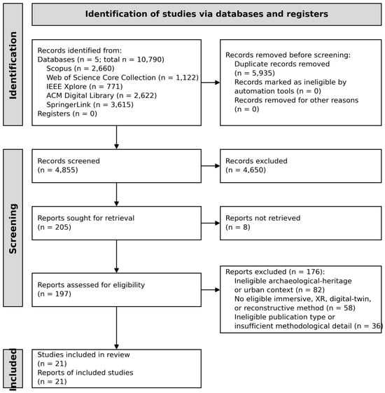
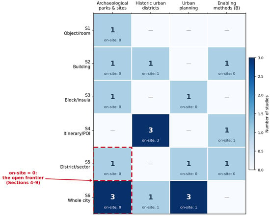
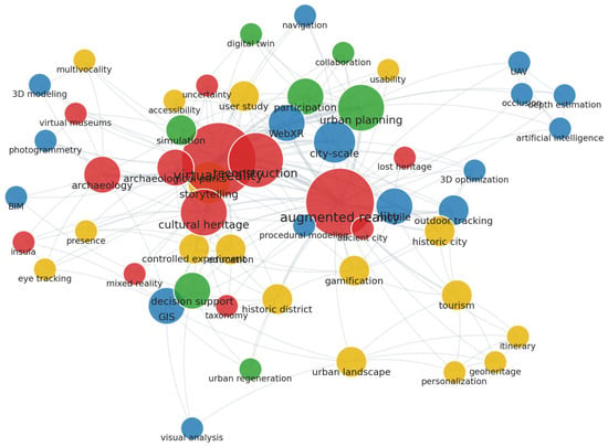
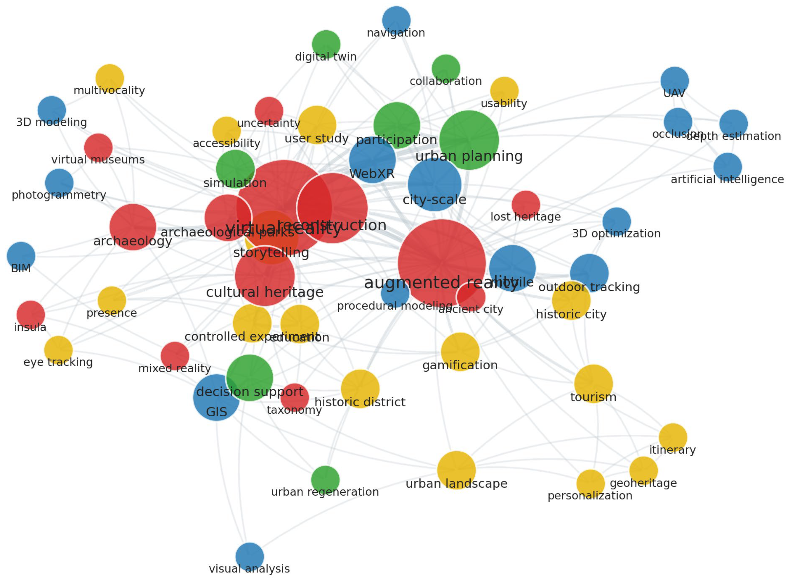
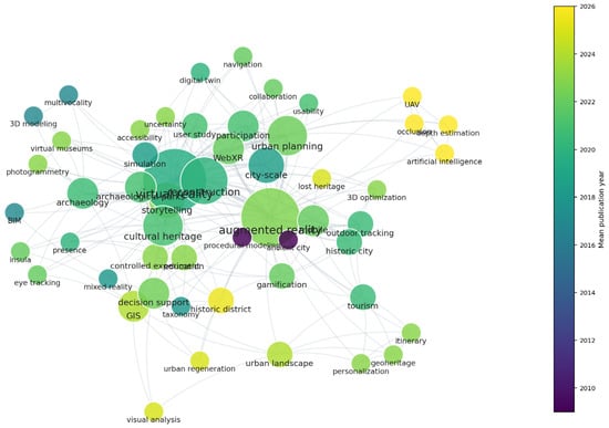
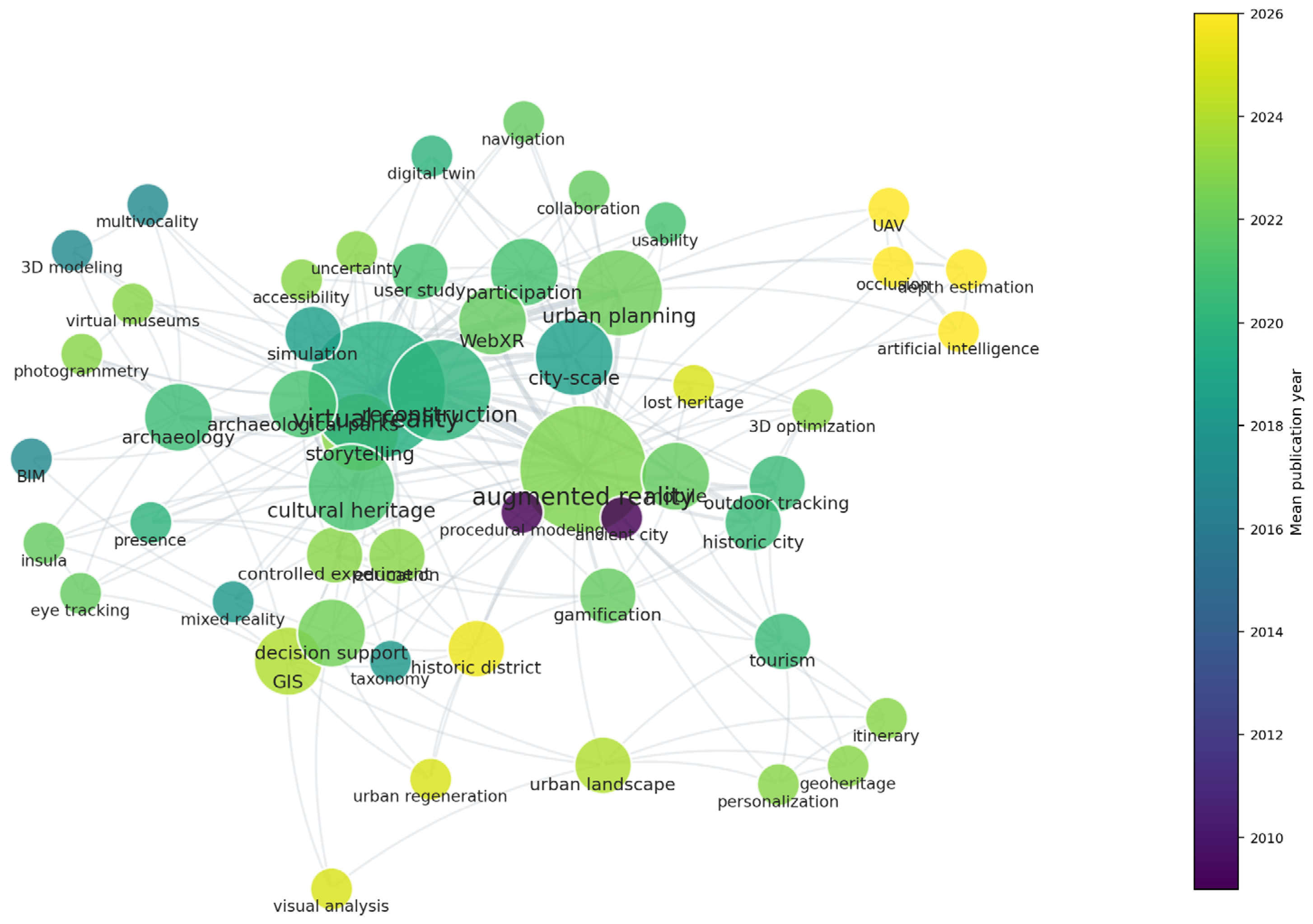
Disclaimer/Publisher’s Note: The statements, opinions and data contained in all publications are solely those of the individual author(s) and contributor(s) and not of MDPI and/or the editor(s). MDPI and/or the editor(s) disclaim responsibility for any injury to people or property resulting from any ideas, methods, instructions or products referred to in the content. |
© 2026 by the authors. Licensee MDPI, Basel, Switzerland. This article is an open access article distributed under the terms and conditions of the Creative Commons Attribution (CC BY) license.