


Abstract
Ensuring the long-term sustainable utilisation of supplemented cropland has become a critical challenge for implementing China’s requisition–compensation balance of farmland (RCBF) policy, particularly in the fragmented hilly and mountainous regions of Southwest China. Existing studies generally evaluate land suitability and utilisation performance separately, making it difficult to identify mismatches between theoretical suitability and actual utilisation and thereby limiting targeted regulation. To address this limitation, this study proposes a suitability–utilisation deviation identification (SUDI) framework, which integrates four sequential analytical components: three-dimensional suitability assessment, suitability–utilisation deviation identification, driving mechanism analysis, and sustainable regulation. Taking Beibei District of Chongqing as a case study, supplemented cropland parcels were identified using the 2020–2024 land change survey data. A three-dimensional suitability evaluation system incorporating production, ecological, and utilisation attributes was established to quantify theoretical land suitability. Actual utilisation performance was characterised using the land economic utilisation coefficient, and suitability–utilisation deviation was identified through residual analysis between theoretical suitability and utilisation intensity. A Bayesian-optimised Extreme Gradient Boosting-SHAP (XGBoost-SHAP) model was subsequently employed to reveal the nonlinear effects and interaction mechanisms of the driving factors. The results indicate the following: (1) supplemented cropland in Beibei District is predominantly characterised by medium-to-high suitability, with high-suitability patches exhibiting a mosaic spatial pattern of local aggregation and overall dispersion; (2) suitability–utilisation deviation is dominated by under-utilised plots, whereas well-matched and over-intensified plots account for substantially smaller proportions, indicating that insufficient realisation of land suitability is the prevailing utilisation pattern; and (3) the land economic utilisation coefficient is the dominant factor driving suitability–utilisation deviation, while high-standard farmland construction and plot area exhibit significant mitigating effects. Moreover, significant interaction effects between utilisation intensity and location-related variables reveal that unfavourable spatial conditions amplify deviation risk under intensive land use. The proposed SUDI framework extends conventional suitability assessment by explicitly linking suitability evaluation with utilisation performance, driving mechanism analysis, and differentiated regulation. It provides a transferable analytical framework for diagnosing suitability–utilisation mismatch and supports dynamic management and sustainable utilisation of supplemented cropland in fragmented hilly and mountainous regions.
1. Introduction
Farmland is the foundation for safeguarding national food security [1,2]. However, with the acceleration of global economic development, the increasing demand for construction land has inevitably led to a substantial reduction in available farmland [3]. The requisition–compensation balance of farmland (RCBF) system, as a core institutional arrangement for farmland protection in China, mandates that any farmland occupied for construction must be compensated with an equivalent quantity and quality of farmland elsewhere [4,5,6]. As the policy orientation shifts from a singular focus on quantity towards the integrated coordination of “quantity–quality–ecology–health” [7], the connotation of supplemented cropland has been continuously deepened. The Third Plenary Session of the 20th Central Committee of the Communist Party of China explicitly called for “reforming and improving the RCBF system and refining the quality acceptance mechanism for supplemented cropland” [8], and the 2026 Central Document No. 1 further issued the directive to “strictly manage the RCBF and standardise the quality acceptance of supplemented cropland.” Against this backdrop, how to scientifically evaluate the suitability of supplemented cropland and ensure its long-term sustainable utilisation has become a critical issue urgently requiring resolution in territorial space governance and comprehensive rural revitalisation.
Chongqing integrates the characteristics of a mega-city, vast rural areas, extensive mountainous terrain, and a major reservoir region, with mountainous and hilly areas accounting for up to 92% of its total land area. The terrain is fragmented and plots are dispersed; the intrinsic quality of farmland resources is weak, and farmland patches are scattered and isolated. According to the latest land change survey data, the total farmland area of the municipality is approximately 1,875,300 hectares, but the number of farmland patches is as high as 4 million, with an average patch size of only about 0.47 hectares. Faced with these inherent deficiencies in farmland resources, in recent years, Chongqing has actively implemented farmland restoration and supplementation policies, adopting measures such as land consolidation and comprehensive land levelling projects to restore and replenish farmland that has been abandoned or irrationally converted to other uses. Since the municipality launched supplemented cropland and farmland restoration actions in 2022, a total of 23,300 hectares of farmland had been restored and replenished by the end of 2023 [9].
However, supplemented cropland in this region commonly exhibits the prominent contradiction of “high suitability, low sustainability.” A large number of plots possess good cultivation potential at the initial stage of supplementation, yet gradually undergo extensive management or even abandonment in subsequent utilisation due to rapid soil fertility decline, inconvenient cultivation conditions, and labour shortages, forming a typical “suitability trap” (In this paper, the term “suitability trap” refers to a structural mismatch phenomenon in which supplemented cropland, despite possessing high cultivation suitability in initial evaluations, exhibits an actual utilisation intensity significantly lower than the theoretical suitability level due to non-natural factors such as remote location, weak infrastructure, and labour outflow, resulting in a “high suitability–low utilisation”.) [10]. If this dynamic process of transitioning from “suitable” to “degraded” is not identified and intervened in a timely manner, it will not only undermine the actual effectiveness of the RCBF policy but may also trigger ecological risks and resource wastage [11]. Therefore, it is imperative to transcend the traditional static suitability evaluation paradigm and construct a research framework capable of tracking the dynamic degradation process and formulating precise regulatory strategies. In this paper, the term “suitability trap” refers to a structural mismatch phenomenon in which supplemented cropland, despite possessing high cultivation suitability in initial evaluations, exhibits an actual utilisation intensity significantly lower than the theoretical suitability level due to non-natural factors such as remote location, weak infrastructure, and labour outflow, resulting in a “high suitability–low utilisation” pattern.
Scholars worldwide have conducted extensive research on the suitability evaluation and sustainable utilisation of supplemented cropland, primarily focusing on the following three aspects. First, research on the identification of supplemented cropland potential and suitability evaluation methods. Early studies primarily employed the Food and Agriculture organization (FAO) land suitability evaluation framework, combined with field surveys and soil sampling, to evaluate the cultivation suitability grades of supplemented cropland from the perspective of natural endowments [12,13]. In recent years, with the widespread adoption of Geographic Information System (GIS) spatial analysis and multi-source remote sensing data, evaluation systems have progressively evolved from a single natural dimension toward multi-dimensional integration of “production–ecology–utilisation” [14,15,16]. Some scholars have introduced combined weighting techniques such as the Analytic Hierarchy Process (AHP), entropy weight method, and Criteria Importance Through Intercriteria Correlation (CRITIC) method to enhance the scientific rigor and objectivity of evaluations [17,18]. Meanwhile, the utilisation suitability of supplemented cropland (e.g., cultivation radius, road accessibility, plot regularity, and connectivity with existing farmland) has received increasing attention, reflecting a cognitive shift from “whether it can be cultivated” to “whether it is easy to use” [19,20]. Furthermore, some scholars, from a cost-effectiveness perspective, have constructed a multi-dimensional evaluation system encompassing compensation costs, consolidation costs, and stability costs to identify spatial priority areas for supplemented cropland [21]. Second, research on the driving factors and dynamic evolution mechanisms of supplemented cropland utilisation. Studies indicate that the subsequent utilisation efficiency of supplemented cropland is closely related to various factors, including soil fertility evolution, agricultural labour supply, agricultural mechanisation levels, cultivation convenience, and subsequent management and protection policies [22,23,24,25]. In the hilly and mountainous areas of Southwest China, problems such as fragmented terrain, farmland fragmentation, and labour outflow are particularly severe, leading to extensive utilisation, rapid soil fertility decline, and even abandonment of some supplemented cropland after supplementation [26]. Recent research has further revealed that the utilisation of supplemented cropland is not static but exhibits a dynamic cycle of “reclamation–utilisation–degradation–restoration,” with its actual contribution to food production potential being far lower than theoretical expectations [27]. Nevertheless, the identification of the dynamic process from “suitable” to “degraded” for supplemented cropland remains insufficient [22]. Third, research on sustainable utilisation regulation strategies and compensation mechanisms for supplemented cropland. At the institutional level, the state has successively introduced policies on quality acceptance and whole-process supervision of supplemented cropland, emphasising the equal importance of “quantity–quality–ecology” [28]. At the technical level, scholars have explored regulatory measures such as soil improvement, engineering support facilities, and optimisation of cropping systems [29]. Some studies have attempted to propose zoning management or differential utilisation recommendations based on the suitability grades of supplemented cropland [14,30]. Regarding compensation mechanisms, scholars have constructed a theoretical framework for cross-regional economic compensation for farmland supplementation at the provincial level, quantifying the ecological service value and compensation standards for supplemented cropland [15,31]. Concurrently, studies targeting urban–rural construction land increase–decrease linkage projects have established a “prior–during–post” three-stage quality grade evaluation procedure for supplemented cropland, providing technical support for quality control of supplemented cropland [32,33]. However, existing regulatory strategies are predominantly static and grade-oriented, lacking dynamic matching and precise intervention for the coupled types of “suitability–utilisation efficiency.”
In summary, although previous studies have made substantial progress in supplemented cropland suitability assessment, utilisation evaluation, and driving factor analysis [1,2,3,4], three major limitations remain. First, most studies rely on static suitability assessment based on natural resource endowments and pay limited attention to whether the cultivation potential of supplemented cropland can be sustainably realised during subsequent utilisation [5,6]. Second, land suitability and utilisation performance are generally evaluated independently, making it difficult to identify plots where actual utilisation deviates from their theoretical suitability [7,8]. As a result, the formation mechanism underlying suitability–utilisation mismatch has not yet been sufficiently explained [9]. Third, existing regulation strategies are primarily grade-oriented and lack an integrated analytical framework capable of linking suitability assessment, deviation identification, driving mechanism analysis, and differentiated regulation, particularly for the fragmented supplemented cropland distributed across the hilly and mountainous regions of Southwest China [10,11,12].
To address these limitations, this study proposes the Suitability–Utilisation Deviation Identification (SUDI) framework (Figure 1), which shifts the analytical focus from conventional static suitability assessment to the diagnosis of the relationship between theoretical suitability and actual utilisation performance. Specifically, the framework explicitly links these two dimensions through residual-based identification of suitability–utilisation deviation at the plot level. Rather than considering suitability assessment as the end point of evaluation, the proposed framework further integrates deviation diagnosis, driving mechanism analysis, and differentiated regulation into a unified analytical framework. Therefore, the primary methodological contribution of this study lies in establishing an integrated “assessment–diagnosis–mechanism–regulation” framework for sustainable supplemented cropland management, rather than simply improving the suitability evaluation model itself. More importantly, the proposed framework enables the identification of whether high theoretical suitability can be effectively translated into sustainable utilisation, thereby providing decision support beyond conventional suitability assessment.
Figure 1.
Overall analytical framework of the proposed Suitability–Utilisation Deviation Identification (SUDI) framework.
Using Beibei District of Chongqing as a representative case of the hilly and mountainous region of Southwest China, this study aims to: (1) evaluate supplemented cropland suitability from production, ecological, and utilisation dimensions; (2) identify suitability–utilisation deviation using the proposed SUDI framework; (3) reveal the driving mechanisms underlying suitability–utilisation deviation based on the Bayesian-optimised XGBoost–SHAP model; and (4) propose differentiated regulation strategies to support the long-term sustainable utilisation of supplemented cropland.
2. Overview of the Study Area and Research Methods
2.1. Overview of the Study Area
Beibei District is one of the central urban districts of Chongqing, located northwest of the city’s core area (Figure 2). It lies within the parallel ridge-valley region in the eastern Sichuan Basin, with terrain dominated by an interlaced distribution of low mountains, hills, and river valleys. The topography is marked by significant relief, with an elevation difference exceeding 1000 metres, rendering it a typical terrain unit of the southwestern hilly and mountainous areas. Administratively, Beibei District governs 9 subdistricts and 8 towns, with a permanent population of approximately 843,100 and an urbanisation rate of 87.81%. It thus faces the dual pressures of rapid development typical of metropolitan suburban areas and the rigid constraints of farmland protection. In terms of territorial space regulation, the district’s farmland retention target by 2035 is no less than 11,627 hectares, with a permanent basic cropland protection target of no less than 8180 hectares. Superimposed with multiple constraints such as urban development boundaries and ecological protection redlines, the land use space exhibits characteristics of stringent regulation and multi-objective gaming. Driven by the RCBF policy, Beibei District has continuously advanced supplemented cropland practices, primarily through the development of low-efficiency forest and garden land, comprehensive land consolidation, and high-standard farmland construction to expand farmland resource supply.
Figure 2.
Geographical location of the study area.
Agriculture in Beibei District exhibits typical characteristics of suburban mountainous agriculture. Benefiting from its proximity to the metropolitan area of Chongqing, agricultural production combines traditional grain cultivation with market-oriented agricultural activities. The main crops include rice, maize, vegetables, and various economic crops. Due to the fragmented mountainous terrain and heterogeneous accessibility conditions, agricultural production is generally characterised by small-scale operation, diversified cropping patterns, and uneven mechanisation levels. These characteristics provide an important socio-economic background for analysing suitability–utilisation deviation of supplemented cropland in this region.
Overall, while phased achievements have been made in the quantitative assurance of regional supplemented cropland, its quality stability and capacity for sustained utilisation still face considerable uncertainty due to factors such as fragmented terrain, farmland patch fragmentation, and imperfect subsequent utilisation and management mechanisms. Therefore, selecting Beibei District as a case study for conducting suitability evaluation and sustainable utilisation regulation of supplemented cropland in the southwestern hilly and mountainous areas possesses both typicality and practical significance.
2.2. Data Sources and Processing
The data sources used in this study are as follows: topographic factors (elevation, slope, etc.) were derived from the 30 m spatial resolution Digital Elevation Model (DEM) provided by the Geospatial Data Cloud (https://www.gscloud.cn, accessed on 5 August 2025). Data on rural settlements, rural roads, and water bodies were obtained from the 2020–2024 land change investigation data of Beibei District. Population density data were sourced from the 100-m spatial resolution population dataset released by the School of Geography and Environmental Science, University of Southampton. Data on geological hazard impact zones and ecological protection redlines were provided by the Beibei District Bureau of Planning and Natural Resources. Soil organic matter and effective soil layer thickness data were obtained from the Beibei District Agricultural Committee. To facilitate overlay analysis, the coordinate systems of all collected spatial data were unified to the China Geodetic Coordinate System 2000 (CGCS2000), and the raster cell size was set to 30 m.
2.3. Overall Framework of the Proposed Suitability–Utilisation Deviation Identification (SUDI) Framework
Existing studies generally evaluate land suitability and actual utilisation performance separately, making it difficult to identify supplemented cropland whose utilisation status deviates substantially from its theoretical suitability. Consequently, the mismatch between land resource endowment and actual utilisation behaviour is often overlooked, and the dynamic mechanism underlying the “suitability trap” remains insufficiently understood. Most existing studies terminate at suitability grading or utilisation evaluation and rarely establish an analytical linkage between land suitability, utilisation performance, driving mechanisms, and adaptive regulation [14,22,34]. To overcome these limitations, this study proposes a Suitability–utilisation Deviation Identification (SUDI) framework. Unlike conventional suitability assessment approaches, the proposed framework introduces the concept of suitability–utilisation deviation, which is defined as the discrepancy between the theoretical suitability of supplemented cropland and its actual utilisation performance. By integrating suitability assessment, deviation identification, driving mechanism analysis, and differentiated regulation into a unified analytical framework, the proposed approach provides a complete methodological pathway from land evaluation to management decision-making.
As illustrated in Figure 1, the proposed SUDI framework consists of four sequential analytical modules that are logically connected to form a complete assessment–diagnosis–interpretation–regulation workflow.
Module 1: Three-dimensional suitability assessment.
The first module evaluates the theoretical suitability of supplemented cropland. Following the conceptual framework of land evaluation proposed by the Food and Agriculture organization (FAO) and recent advances in GIS-based multi-criteria suitability assessment [34,35], supplemented cropland is regarded as a coupled socio-ecological production system rather than merely a natural land resource. Accordingly, a three-dimensional evaluation system integrating production suitability, ecological suitability, and utilisation suitability is established. After indicator standardisation, objective weighting, and spatial overlay analysis, a comprehensive suitability index is calculated for each supplemented cropland plot to represent its theoretical development potential.
Module 2: Suitability–utilisation deviation identification.
The second module constitutes the methodological core of the proposed SUDI framework. Actual utilisation performance is characterised using the land economic utilisation coefficient, which reflects the comprehensive intensity of land use. A residual-based deviation index is subsequently constructed by calculating the difference between theoretical suitability and actual utilisation intensity. Positive and negative residuals represent different mismatch patterns between land resource endowment and utilisation behaviour, while the magnitude of the residual indicates the severity of deviation. Based on the statistical distribution of residual values, supplemented cropland plots are classified into three deviation types, namely under-utilised, well-matched, and over-intensified. Compared with traditional suitability grading, this procedure explicitly identifies plots whose actual utilisation departs from theoretically suitable levels, thereby providing a quantitative indicator for diagnosing the suitability trap.
Module 3: Driving mechanism analysis.
After identifying suitability–utilisation deviation, the third module investigates its underlying driving mechanisms. Considering the nonlinear relationships and complex interactions among multiple influencing factors, this study employs a Bayesian-optimised XGBoost-SHAP model to quantify the contribution of different explanatory variables. Bayesian optimisation is adopted to improve model performance through automatic hyperparameter tuning, while SHAP (Shapley Additive Explanations) is used to interpret model outputs from both global and local perspectives. Through SHAP value decomposition and interaction analysis, the relative importance, influence direction, threshold characteristics, and interaction mechanisms of different driving factors are quantitatively identified, thereby revealing how natural conditions, engineering attributes, location accessibility, and utilisation behaviour jointly influence suitability–utilisation deviation.
Module 4: Sustainable regulation.
The final module transforms analytical results into management recommendations. Based on the identified deviation types and their corresponding driving mechanisms, differentiated regulation strategies are proposed from three complementary perspectives: graded utilisation intensity control, spatial zoning governance, and engineering condition optimisation. Instead of relying solely on suitability grades, the proposed framework incorporates deviation characteristics into the decision-making process, enabling adaptive regulation according to different mismatch types. Consequently, supplemented cropland management can gradually shift from traditional one-time quality acceptance toward a dynamic life-cycle management approach integrating admission, monitoring, regulation, and exit, thereby improving the long-term sustainability of supplemented cropland utilisation.
Overall, the proposed SUDI framework extends the conventional land suitability assessment paradigm by explicitly introducing a deviation-identification perspective that links theoretical suitability with actual utilisation performance. More importantly, it establishes a complete analytical chain connecting suitability assessment, deviation diagnosis, driving mechanism interpretation, and adaptive regulation. Therefore, the framework not only provides a transferable methodological paradigm for diagnosing suitability–utilisation mismatch but also offers practical decision support for the sustainable management of supplemented cropland in fragmented hilly and mountainous regions.
2.4. Research Methods
Following the SUDI framework described above, this study was implemented through four methodological procedures, including (1) three-dimensional suitability assessment, (2) suitability–utilisation deviation identification, (3) Bayesian-optimised XGBoost-SHAP analysis, and (4) formulation of sustainable regulation strategies.
2.4.1. Identification of Supplemented Cropland
According to the Measures for the Quality Acceptance of Supplemented Cropland (Trial) issued by the Ministry of Agriculture and Rural Affairs of China, supplemented cropland refers to newly created cultivated land that has been reclaimed or restored from other land-use types through legally approved land consolidation or restoration projects and is capable of long-term stable agricultural production. Following this definition, supplemented cropland was identified using the land change survey data of Beibei District from 2020 to 2024. Cultivated land existing in 2020 was regarded as the baseline, and the year in which each land parcel was first converted into cultivated land was extracted from the annual land use change database. Parcels newly converted into cultivated land during 2020–2024 were identified as supplemented cropland and used as the research subjects of this study.
2.4.2. Three-Dimensional Suitability Assessment
The three-dimensional suitability evaluation framework was established based on the understanding that the sustainable utilisation of supplemented cropland depends not only on natural production conditions but also on ecological security and long-term utilisation feasibility. Previous studies have demonstrated that evaluating cropland solely from the perspective of natural suitability cannot fully reflect its sustainable utilisation potential because socio-economic accessibility and ecological constraints also play indispensable roles in determining long-term land-use performance [13,15,20,24]. Therefore, this study organises the indicator system into three complementary dimensions—production suitability, ecological suitability, and utilisation suitability—to comprehensively characterise the multiple constraints affecting the sustainable utilisation of supplemented cropland.
Based on the above theoretical framework, a three-dimensional suitability evaluation system was established to quantify the theoretical suitability of supplemented cropland. The framework follows the principles of the FAO land evaluation system while incorporating recent advances in GIS-based multi-criteria land suitability assessment and the policy requirements for high-quality supplemented cropland under China’s requisition–compensation balance policy [14,15,34]. Specifically, the production dimension characterises the natural productivity of farmland through indicators describing terrain, irrigation conditions, and soil fertility. Among these indicators, slope was included as a key negative factor because steep terrain may restrict mechanised farming operations and increase risks of soil erosion and nutrient loss. Therefore, slope was treated as a continuous constraint indicator rather than a simple exclusion threshold, allowing the evaluation to capture gradual variations in agricultural suitability across mountainous landscapes. The ecological dimension evaluates ecological constraints and environmental security, including geological hazard risk and ecological protection requirements. The utilisation dimension reflects the long-term feasibility of agricultural production from the perspectives of accessibility, management convenience, plot morphology, and labour availability.
To minimise subjective bias in indicator weighting, three objective weighting methods, namely the entropy weight method, coefficient of variation method, and the CRITIC method, were jointly adopted. To reduce the dependence on any single weighting algorithm while preserving the complementary strengths of different objective weighting approaches, the final indicator weights were obtained by integrating the entropy weight method, coefficient of variation method, and CRITIC method using a ratio of 0.3:0.3:0.4, respectively. A slightly higher weight was assigned to the CRITIC method because it simultaneously accounts for both indicator variability and inter-indicator correlations, thereby providing a more comprehensive evaluation of indicator information than the other two methods. By contrast, the entropy weight method and coefficient of variation method primarily reflect indicator dispersion from different statistical perspectives and were therefore assigned equal contributions. To further evaluate the robustness of the adopted weighting strategy, a sensitivity analysis based on three alternative weighting scenarios was conducted (Table 2). The results demonstrated that the suitability evaluation remained highly consistent under different weighting combinations, indicating that the selected weighting ratio had a negligible influence on the overall evaluation results. The comprehensive suitability index was subsequently calculated using a weighted linear combination model.
where denotes the suitability index of plot i; represents the integrated weight of indicator j; denotes the standardised value of indicator j for plot i. The evaluation indicators and their corresponding weights are presented in Table 1.
Table 1.
Suitability evaluation indicator system for supplemented cropland.
To evaluate the robustness of the adopted weighting integration strategy, a sensitivity analysis was conducted by comparing the baseline weighting scheme (0.3:0.3:0.4) with three alternative weighting scenarios, including equal weighting (0.33:0.33:0.33), CRITIC-Dominant weighting (0.2:0.2:0.6), and entropy-dominant weighting (0.5:0.25:0.25). The suitability indices derived from each weighting scenario were subsequently compared using Spearman rank correlation coefficients to assess the stability of plot rankings under different weighting combinations. The corresponding results are presented in Table 2.
Table 2.
Spearman rank correlations of suitability indices under different weighting scenarios.
As shown in Table 2, the Spearman rank correlation coefficients among all weighting scenarios ranged from 0.968 to 0.999, indicating a consistently high degree of agreement in suitability rankings. Even under substantially different weighting combinations, the overall spatial distribution and relative ranking of suitability remained highly stable. These results demonstrate that the proposed suitability evaluation framework is robust to reasonable variations in the weighting integration strategy, suggesting that the adopted weighting ratio (0.3:0.3:0.4) does not substantially influence the subsequent suitability–utilisation deviation analysis.
2.4.3. Suitability–Utilisation Deviation Identification
Within the proposed SUDI framework, suitability–utilisation deviation was quantified as the residual between the standardised theoretical suitability index and the standardised actual utilisation index. Conventional suitability evaluation mainly focuses on assessing the theoretical cultivation potential of farmland, whereas the proposed method further examines whether such potential has been effectively translated into actual utilisation.
Actual utilisation performance was represented by the land economic utilisation coefficient, which was calculated by integrating the agricultural economic output and land utilisation characteristics of each supplemented cropland plot. The coefficient reflects the relative intensity of land utilisation by quantifying the economic benefits generated per unit area of cultivated land. Compared with conventional land-use intensity indicators, this coefficient provides a more comprehensive proxy for actual utilisation performance because it simultaneously considers agricultural production efficiency and land-use intensity. The coefficient was calculated at the plot level based on the official cultivated land quality assessment database and land use survey data provided by the Beibei District Bureau of Natural Resources, ensuring consistency with the spatial resolution of the suitability assessment.
In the above equation, represents the suitability–utilisation deviation of plot i; represents standardised suitability index; and represents standardised land economic utilisation coefficient.
Since both the suitability index and the land economic utilisation coefficient were standardised before calculating the residuals, the deviation index reflects only the relative difference between theoretical suitability and actual utilisation performance rather than their original measurement units.
The deviation index was defined as the residual between the standardised actual utilisation index and the standardised theoretical suitability index (Residual = Actual utilisation − Theoretical suitability). Consequently, positive residuals indicate that actual utilisation exceeds the theoretically appropriate level (over-intensification), whereas negative residuals indicate insufficient utilisation relative to land suitability (underutilisation). The absolute value of the residual reflects the magnitude of deviation. Defining the deviation index as the residual between actual utilisation and theoretical suitability enables positive values to directly indicate utilisation beyond the theoretically appropriate level, whereas negative values represent insufficient utilisation relative to the inherent land potential. This formulation provides an intuitive interpretation of suitability–utilisation mismatch while maintaining consistency with conventional residual analysis.
Following the statistical characteristics of the residual distribution, supplemented cropland was classified using the symmetric standard deviation threshold as follows:
where δ denotes the standard deviation of the residuals. The threshold of ±0.5 standard deviation was adopted following established practices in spatial ecology and resource selection modelling [36,37]. Statistically, this value approximates the mean absolute deviation (MAD) of the residuals, providing an optimal compromise between excluding natural stochastic fluctuations and capturing genuine deviation signals. A more stringent threshold (e.g., ±0.3σ_R) risks high-frequency misclassification due to normal noise, whereas a looser threshold (e.g., ±1.0σ_R) tends to mask true mismatches. This methodological choice aligns with classic studies on resource selection functions and ecological model validation, which widely recognize the ±0.5σ_R envelope as a robust statistical boundary for distinguishing natural variability from actual ecological deviation. Moreover, recent applications in land use and spatial mismatch analysis have confirmed its effectiveness [37]. Consequently, ±0.5σ_R was employed in this study to ensure both classification sensitivity and statistical stability.
2.4.4. Bayesian-Optimised XGBoost-SHAP Analysis
To reveal the mechanisms driving suitability–utilisation deviation, a Bayesian-optimised XGBoost model was developed. Considering that the suitability index had already incorporated natural endowment factors such as topography and soil properties, introducing these variables again would result in structural collinearity between explanatory and response variables. Therefore, the driving factors focused primarily on human-related variables, including location conditions, engineering conditions, utilisation characteristics, and socio-economic environment. The explanatory variables included: distance to village committee; high-standard farmland status; supplementation duration; distance to rural business formats; land economic utilisation coefficient; plot area. Bayesian optimisation was employed to automatically determine the optimal hyperparameters of the XGBoost model, thereby improving predictive performance and reducing the risk of overfitting. Subsequently, the SHAP (Shapley Additive Explanations) algorithm was introduced to interpret the trained model. Global SHAP values were calculated to rank variable importance, while local SHAP values and SHAP interaction values were used to reveal nonlinear response patterns and interaction mechanisms among variables. Compared with conventional regression models, the Bayesian-optimised XGBoost-SHAP framework can simultaneously capture nonlinear relationships, threshold effects, and variable interactions while maintaining high interpretability [25].
It should be noted that the primary objective of the Bayesian-optimised XGBoost-SHAP model in this study is explanatory rather than predictive. Specifically, the model is intended to identify the key drivers of suitability–utilisation deviation, quantify their relative importance, and reveal nonlinear relationships and interaction mechanisms, rather than to maximise prediction accuracy. This modelling objective is consistent with the distinction between explanatory and predictive modelling proposed by Shmueli (2010) [38], which emphasises that models developed to explain underlying mechanisms should be evaluated primarily according to their interpretability and explanatory value rather than their predictive performance alone. Accordingly, the XGBoost-SHAP framework was adopted to provide a transparent interpretation of the mechanisms underlying suitability–utilisation deviation instead of constructing a high-precision prediction model.
2.4.5. Formulation of Sustainable Regulation Strategies
Based on the identified suitability–utilisation deviation types and the corresponding driving mechanisms, differentiated regulation strategies were formulated. The proposed regulation framework consists of three complementary components. First, graded utilisation intensity control was designed according to different deviation types to prevent both underutilisation and excessive exploitation. Second, spatial zoning governance was proposed by integrating deviation characteristics with regional location conditions, thereby achieving differentiated management of supplemented cropland. Third, engineering condition optimisation was recommended through high-standard farmland construction, plot consolidation, and long-term monitoring, aiming to improve the sustainability of supplemented cropland utilisation. Together, these procedures establish a complete methodological chain linking assessment, diagnosis, mechanism interpretation, and management intervention, which represents the overall implementation process of the proposed SUDI framework.
3. Results and Analysis
3.1. Spatial Distribution Pattern of Supplemented Cropland Suitability
To highlight the spatial differentiation characteristics of supplemented cropland suitability, this paper classified the suitability index into three grades—low suitability, medium suitability, and high suitability—using the equal interval classification method. Given the limited number of supplemented cropland plots and their small patch areas in Beibei District, area fills have low recognizability in large-scale mapping. Therefore, each plot was converted to a centroid point, with the size and color of the point indicating the suitability grade, thereby more clearly presenting the spatial hierarchy and agglomeration pattern of plot grades.
The suitability of supplemented cropland in Beibei District overall presents a spatial distribution pattern characterised by medium-grade plots spreading across the entire area, high-suitability plots locally concentrated, and low-suitability plots sporadically interspersed (Figure 3). Various suitability grade plots are nested within each other, exhibiting significant spatial interleaving and concentric transition characteristics. Medium-suitability units constitute the regional base framework, contiguously covering the vast majority of towns and subdistricts across the entire area, with a wide distribution range and strong spatial continuity, forming several relatively continuous advantageous zones in areas such as Jingguan Town, Sansheng Town, and Liuyin Town. High-suitability patches account for a relatively limited proportion, mostly interspersed and embedded within the medium-suitability matrix, displaying a characteristic of “local agglomeration, overall dispersion.” They form prominent concentrated clusters with significant scale in the northern part of the region, exhibiting outstanding contiguous advantages and providing core potential space for large-scale farmland quality improvement and transformation. Low-suitability plots do not exhibit extensive continuous distribution but are mostly scattered as fine, isolated patches across the western part and peripheral fringe areas, forming relatively concentrated low-value patches in areas such as Tianfu Town, Chengjiang Town, and Xiema Subdistrict, with the remaining areas showing sporadic distribution. Overall, the three types of plots are interlaced and embedded in a mosaic pattern: high-suitability clusters are surrounded and enveloped by medium-suitability plots, while low-suitability fine patches are inlaid at the edges of the overall pattern. The regional farmland improvement potential presents a pattern of northern agglomeration, widespread distribution of medium-suitability plots, and sporadic interleaving of low-suitability plots.
Figure 3.
Spatial distribution of the supplemented cropland suitability index in Beibei District.
3.2. Spatial Distribution of Suitability–Utilisation Deviation Types
3.2.1. Overall Distribution and Statistical Characteristics
Based on the statistical distribution characteristics calculated from the residual term, this paper adopts the symmetric standard deviation threshold method (δ = 0.5σR) to classify the supplemented cropland in Beibei District into three types: underutilised type (Ri < –δ), well-matched type (–δ < Ri < δ), and over-intensified type (Ri > δ). Figure 4 and Figure 5 presents the density distribution of the three suitability–utilisation deviation types in the two-dimensional space defined by theoretical suitability and actual utilisation intensity, along with the quantitative composition and proportions of each category. The density heatmap shows that the distribution of supplemented cropland patches in Beibei District exhibits a significantly asymmetric characteristic, with the vast majority of patches concentrated below the diagonal (Ei = Si) region, indicating that “inadequate release of suitability” is the overall characteristic of supplemented cropland utilisation deviation in the study area. The quantitative statistical results further quantify this distribution: the underutilised type comprises 4226 patches (66.4%), constituting the dominant type; the well-matched type comprises 1537 patches (24.2%); and the over-intensified type comprises only 597 patches (9.4%), presenting a cascading decreasing pattern of “underutilised type > well-matched type > over-intensified type” (Figure 5). The above structure is highly consistent with the topographical conditions and socio-economic characteristics of Beibei District. The proportion of farmland with slopes greater than 15° exceeds 35.6% district-wide, patches are sporadically scattered with an average size of only 0.43 hectares, the degree of fragmentation is high, mechanisation is difficult, the urbanisation rate is as high as 87.81%, and the continuous outflow of rural labour has led to the widespread existence of “high suitability–low utilisation” deviation. The lowest proportion of the over-intensified type indicates that under natural endowment constraints, the “low suitability–high intensity” mismatch is not a common phenomenon. The gradient differentiation among the three types reveals that a certain degree of mismatch still exists between resource endowments and utilisation intensity.
Figure 4.
Spatial distribution of various types of suitability trap plots for supplemented cropland in Beibei District.
Figure 5.
Density distribution heatmap and quantitative proportion of utilisation deviation types for supplemented cropland in Beibei District.
3.2.2. Cross-Analysis Between Suitability Grades and Deviation Types
Cross-analysis of suitability grades and deviation types can further reveal the spatial correspondence between the two (Table 3). From the row-wise perspective, low-suitability plots are dominated by the well-matched type (47.05%), but the proportion of the over-intensified type reaches 21.59%, the highest among the three types, indicating that low-suitability plots face a certain degree of over-utilisation pressure; medium-suitability plots are dominated by the under-utilised type (64.56%), followed by the well-matched type (24.65%); in high-suitability plots, the proportion of the under-utilised type is as high as 82.18%, while the well-matched type accounts for only 15.89%, and the over-intensified type only 1.93%, indicating that the utilisation potential of high-suitability plots is far from fully released, constituting the core carriers of the “suitability trap.” From the column-wise perspective, within the under-utilised type, medium-suitability plots account for 65.14% and high-suitability plots account for 31.21%, together exceeding 96%, indicating that the under-utilisation problem is highly concentrated in medium- and high-suitability grades. The above cross-relationship indicates that the mismatch between suitability and utilisation intensity exhibits a clear grade selectivity—the higher the suitability, the greater the risk of under-utilisation; the lower the suitability, the relatively higher the probability of over-intensification. This provides a classification basis for subsequent differentiated regulation: high suitability–under-utilisation areas should focus on improving location and facility conditions to stimulate utilisation potential; low suitability–over-intensification areas require vigilance against ecological risks and the implementation of intensity control.
Table 3.
Cross-analysis of suitability grades and deviation types for supplemented cropland in Beibei District.
3.2.3. Robustness Test of Threshold Selection
To further evaluate the robustness of this classification threshold, we conducted a sensitivity analysis by employing two alternative threshold settings: ±0.3σ_R (δ = 0.0412) and ±1.0σ_R (δ = 0.1375) (Table 4). Under the stricter threshold of ±0.3σ_R, the proportions were under-utilised (73.4%), well-matched (14.2%), and over-intensified (12.5%). Conversely, under the more lenient threshold of ±1.0σ_R, the proportions shifted to under-utilised (46.3%), well-matched (49.9%), and over-intensified (3.8%). Notably, despite the changes in absolute proportions, the overarching spatial pattern remained remarkably consistent across all thresholds: the proportion of under-utilised plots consistently and significantly exceeded that of over-intensified plots (e.g., 73.4% vs. 12.5% for 0.3σ_R, and 46.3% vs. 3.8% for 1.0σ_R). This cross-validation confirms that the core conclusion of the study—that insufficient realisation of land suitability (under-utilisation) is the prevailing utilisation mode in the study area—is not an artifact of the chosen threshold. Therefore, the ±0.5σ_R classification scheme is considered robust and representative for capturing the suitability–utilisation mismatch pattern in Beibei District.
Table 4.
Classification results of suitability–utilisation deviation types under different residual thresholds.
3.3. Driving Mechanisms of Suitability–Utilisation Deviation
3.3.1. Importance and Structural Characteristics of Driving Factors
Based on the Bayesian-optimised XGBoost–SHAP model, this study quantitatively identified the driving mechanisms underlying suitability–utilisation deviation. The model achieved a test-set R2 of 0.313, indicating that the selected driving factors explained approximately 31.3% of the variation in suitability–utilisation deviation. Although the coefficient of determination is moderate, it should be interpreted in light of the objective of this study. First, the primary purpose of the model is to identify the key driving factors and explain their influence mechanisms rather than to maximise predictive accuracy. According to the distinction between explanatory modelling and predictive modelling proposed by Shmueli (2010) [38], the primary objective of explanatory modelling is to identify the underlying relationships among variables rather than to maximise predictive accuracy. Therefore, under the explanatory modelling framework adopted in this study, model interpretability and the reliability of variable importance are more important than achieving a particularly high goodness-of-fit. Second, the dependent variable (Ri) represents the residual between theoretical suitability and actual utilisation, which largely removes the influence of natural endowment factors such as topography and soil conditions. Consequently, the remaining variation is more likely to be associated with micro-level management behaviours, household decision-making, and other socio-economic factors that cannot be fully captured by currently available spatial datasets. Third, the subsequent SHAP analysis exhibits a clear hierarchical structure of variable importance, and the directions of variable effects are generally consistent with theoretical expectations, indicating that the model provides a stable basis for interpreting the driving mechanisms of suitability–utilisation deviation. Therefore, although the predictive performance is moderate, the model is considered appropriate for explaining the driving mechanisms underlying suitability–utilisation deviation and provides a reliable basis for subsequent SHAP interpretation.
From the perspective of driving factor importance (Figure 6), the contribution of each variable exhibits a clear hierarchical pattern. Among all variables, the land economic utilisation coefficient shows the highest explanatory power, with the largest mean absolute SHAP value, indicating that utilisation intensity is the dominant factor driving suitability–utilisation deviation. This finding suggests that suitability deviation is not simply caused by insufficient natural suitability but is more closely associated with the mismatch between human utilisation intensity and the utilisation potential of supplemented cropland. In comparison, distance to the village committee, distance to rural business centres, plot area, and high-standard farmland construction constitute the second tier of driving factors. Their relatively similar SHAP values indicate that location conditions and engineering attributes jointly influence suitability–utilisation deviation. Specifically, distance to the village committee and distance to rural business centres reflect the accessibility of production services and regional economic vitality, thereby indirectly influencing agricultural investment and utilisation intensity. Meanwhile, plot area and high-standard farmland construction enhance the resistance of supplemented cropland to degradation through economies of scale and improved infrastructure. Their predominantly negative SHAP values further indicate that large-scale management and engineering improvement can effectively mitigate the risk of suitability–utilisation deviation.
Figure 6.
SHAP importance ranking of various driving factors for degradation risk of supplemented cropland in Beibei District.
3.3.2. Direction of Driving Factor Effects and Interaction Effects
SHAP dependence analysis further reveals the direction of action of each driving factor. The results show (Table 5) that the land economic utilisation coefficient exhibits a significant positive effect, indicating that the higher the utilisation intensity, the greater the risk of the plot deviating from the theoretical suitability level. This corroborates the process mechanism of “high-intensity utilisation—potential degradation risk accumulation” from a lateral perspective. Meanwhile, high-standard farmland construction, distance to rural business formats, and plot area all demonstrate negative effects, indicating that engineering transformation and scale operation can effectively enhance the stability of the farmland system. The direction of action of location variables is relatively weak, but under specific conditions, they may indirectly amplify the deviation effect by influencing input structure and management mode.
Table 5.
Mean SHAP values and direction of action of each driving factor in Beibei District.
The SHAP interaction effect analysis reveals the coupling characteristics of the driving mechanisms (Figure 7). The results indicate that there are significant interaction effects between the land economic utilisation coefficient and location variables, among which the interaction effects with distance to village committee and distance to rural business formats are the most prominent, with interaction intensities approaching the main effect level of single variables. This suggests that the utilisation intensity of supplemented cropland plots does not act in isolation, but rather jointly determines deviation risk together with spatial accessibility and the regional economic environment. When high utilisation intensity is superimposed on unfavourable location conditions, supplemented cropland plots are more likely to breach their suitability threshold, thereby exacerbating the formation of “suitability–utilisation deviation”.
Figure 7.
Interaction effects of various driving factors on degradation risk of supplemented cropland in Beibei District.
3.3.3. Integrated Mechanism of Suitability–Utilisation Deviation
Suitability–utilisation deviation in supplemented cropland is not dominated by a single factor, but rather represents a complex response process driven by the coupling of multi-dimensional elements. In essence, it is the dynamic evolutionary result of the interaction among utilisation behaviour, spatial constraints, and production conditions.
Among these, the continuous increase in land utilisation intensity is the direct driving force for deviation formation. In the hilly and mountainous areas of Southwest China, farmland resources exhibit strong spatial heterogeneity and limited carrying capacity. When utilisation intensity continuously increases and approaches or even exceeds the carrying threshold of the plot, system stability declines, and the deviation between theoretical suitability and actual utilisation performance widens accordingly. This process exhibits nonlinear characteristics, presenting phased differences and threshold effects across different utilisation intensity intervals.
Spatial location exerts a continuous embedded influence on the above process by affecting the acquisition of production factors and management conditions. Beibei District possesses the dual attributes of a metropolitan fringe and a hilly and mountainous region, with significant differences in transportation accessibility, industrial development, and labour allocation across different areas, resulting in differentiated outcomes for the same utilisation intensity under different location conditions. In areas with advantageous locations, high-intensity utilisation can be supported through factor replenishment and technical input, maintaining relative stability; whereas in remote hilly areas, high-intensity utilisation is more likely to overdraw plot carrying capacity, accelerating deviation.
The engineering conditions and scale characteristics of farmland itself also continuously reshape the system’s response mode. High-standard farmland construction and scale operation have improved the infrastructure and management mode of some plots, enhancing their adaptive capacity to high-intensity utilisation, delaying or even offsetting deviation. In contrast, in areas with fragmented plots and weak infrastructure, the system exhibits higher sensitivity to external disturbances, and changes in utilisation intensity are more likely to trigger suitability–utilisation deviation.
4. Dynamic Regulation Strategies for Sustainable Utilisation of Supplemented Cropland
Based on the driving mechanism of suitability–utilisation deviation, this paper proposes regulation strategies from three dimensions: utilisation control, zoning governance, and engineering optimisation.
- (1)
- Graded Utilisation Intensity Control. The land economic utilisation coefficient is the primary factor driving deviation, indicating that the continuous increase in utilisation intensity is the direct driving force inducing deviation. It is recommended to use this coefficient as the core early warning indicator and set differentiated control thresholds based on plot suitability grades: For high suitability–underutilisation type plots, the problem lies in insufficient rather than excessive utilisation intensity. Production potential should be moderately released, with a focus on activating utilisation willingness by improving location accessibility and infrastructure. For low suitability–over-intensification type plots, strict utilisation intensity upper limits should be set, implementing measures such as input reduction, crop rotation fallowing, or planting structure adjustment to prevent breaching the resource carrying capacity. For plots that have already exhibited significant degradation, soil improvement and fertility enhancement restoration procedures should be initiated.
- (2)
- Spatial Zoning Governance. The SHAP interaction effect analysis indicates that there are significant interaction effects between distance to village committee, distance to rural business formats, and the land economic utilisation coefficient, and that high utilisation intensity superimposed on unfavourable location conditions amplifies deviation risk. Based on this, differentiated zoning strategies are proposed: The northern high-suitability cluster area (where underutilisation type is concentrated but the suitability background is superior) should be incorporated into the core conservation zone, with priority given to high-standard farmland construction, reducing location constraints by improving road accessibility and agricultural service accessibility, and activating utilisation potential. The medium-suitability contiguous areas such as Jingguan–Sansheng–Liuyin should implement flexible management, focusing on promoting scattered plot consolidation and moderate scale operation. The western marginal low-value agglomeration areas such as Tianfu, Chengjiang, and Xiema should strictly limit high-intensity utilisation, and for plots that are truly unsuitable for cultivation, explore conversion to other uses or land retirement.
- (3)
- Engineering Condition optimisation and Whole-Cycle Management. High-standard farmland construction and plot area both exhibit negative inhibitory effects, verifying the positive role of engineering transformation and scale operation in reducing deviation risk. It is recommended to prioritise the inclusion of supplemented cropland with a relatively high degree of contiguity into high-standard farmland construction, simultaneously promote scattered plot consolidation, and establish a full-chain mechanism of “construction–management and protection–assessment” to prevent the attenuation of engineering benefits. On this basis, promote the transformation of supplemented cropland management from one-time acceptance to a full life-cycle management approach of “admission–monitoring–regulation–exit”: the admission phase uses the dual thresholds of suitability index and location conditions as screening criteria; the monitoring phase uses the Suitability–utilisation Deviation Index (SUDI) as the core early warning indicator; and the exit phase implements orderly exit for plots with severe degradation and excessively high restoration costs, thereby achieving the dynamic optimal allocation of farmland resources.
5. Conclusions
Taking Beibei District of Chongqing as the study area and using the 2020–2024 land change survey data, this study developed a Suitability–utilisation Deviation Identification (SUDI) framework that integrates three-dimensional suitability assessment, suitability–utilisation deviation identification, driving mechanism analysis, and sustainable regulation. By explicitly linking theoretical land suitability with actual utilisation performance, the proposed framework reveals the spatial characteristics, formation mechanisms, and regulation pathways of suitability–utilisation deviation in supplemented cropland. The major conclusions are summarised as follows.
- (1)
- Supplemented cropland in Beibei District is generally characterised by medium-to-high suitability, exhibiting a mosaic spatial pattern with localised clustering and overall dispersion. High-suitability plots are mainly distributed in contiguous agricultural areas, whereas low-suitability plots are scattered along the western mountainous margins.
- (2)
- The utilisation pattern presents a distinct structural hierarchy of underutilised > well-matched > over-intensified. Approximately two-thirds of supplemented cropland belongs to the underutilised type, indicating that insufficient utilisation rather than excessive exploitation represents the dominant form of suitability–utilisation deviation. Underutilised plots are mainly concentrated within medium- and high-suitability areas, while over-intensified plots are primarily distributed in environmentally constrained locations with relatively poor natural conditions.
- (3)
- The Bayesian-optimised XGBoost-SHAP model demonstrates that the land economic utilisation coefficient is the most influential driver of suitability–utilisation deviation. High-standard farmland construction and plot area exhibit significant negative effects on deviation, indicating that engineering improvement and scale operation effectively enhance system resilience. Meanwhile, location variables, including distance to village committee and distance to rural business formats, interact significantly with utilisation intensity, revealing an amplification mechanism whereby unfavourable location conditions exacerbate deviation under intensive land use.
- (4)
- Suitability–utilisation deviation is essentially a dynamic consequence of interactions among utilisation behaviour, spatial accessibility, and production conditions. Accordingly, sustainable management of supplemented cropland should shift from one-time quality acceptance toward a life-cycle management framework integrating admission, monitoring, regulation, and exit, thereby promoting the coordinated improvement of cropland quantity, quality, and utilisation efficiency.
6. Discussion
6.1. Comparison with Existing Studies and Methodological Contributions
Previous studies have substantially advanced the evaluation of supplemented cropland from the perspectives of land suitability assessment, cultivated land quality monitoring, and utilisation performance evaluation. Existing suitability assessment frameworks have gradually evolved from traditional evaluations based solely on natural resource endowments toward multidimensional systems integrating production conditions, ecological constraints, and engineering characteristics [13,15,20,24,34]. Recent studies have further incorporated ecological security, land consolidation potential, and multifunctionality into suitability evaluation, providing important methodological support for identifying high-quality cultivated land resources under China’s new requisition–compensation balance of farmland (RCBF) policy [18,21,24]. Nevertheless, these approaches generally treat suitability assessment as the endpoint of analysis and implicitly assume that land with higher suitability will achieve better utilisation outcomes. Consequently, the relationship between theoretical suitability and actual utilisation performance has received relatively limited attention [14,15,34].
A parallel research stream has focused on the utilisation efficiency and sustainability of supplemented cropland. Previous studies have investigated cropland abandonment, non-grain production, utilisation efficiency, and farmland quality evolution using remote sensing, statistical analysis, and spatial econometric methods [10,18,19,22]. These studies consistently demonstrate that utilisation outcomes are jointly influenced by natural resource endowments, engineering conditions, and socio-economic factors rather than by land quality alone. For example, Lu et al. [10] reported that mountainous terrain, fragmented plots, and labour outmigration substantially constrain the utilisation efficiency of supplemented cropland in Southwest China. Guo et al. [22] further revealed significant spatial mismatches between cropland supplementation and abandonment, while Xie et al. [23] showed that cropland supplementation in mountainous areas may even aggravate non-grain production because of increasing competition between agricultural and non-agricultural land uses. Collectively, these findings indicate that high land suitability cannot automatically guarantee sustainable utilisation.
Although these two research streams have considerably enriched the understanding of supplemented cropland management, they remain largely independent. Suitability evaluation usually ends with land grading, whereas utilisation studies mainly assess land-use performance without explicitly examining whether actual utilisation is consistent with theoretical suitability [14,22,24]. As a result, the mechanisms underlying the mismatch between theoretical suitability and actual utilisation remain insufficiently understood. Similar concerns have recently been emphasised in international land system science, which argues that land-use outcomes emerge from the coupled interactions between biophysical suitability and human decision-making rather than from natural resource conditions alone [36,37,38,39,40].
Against this background, the proposed SUDI framework bridges the gap between conventional suitability assessment and utilisation evaluation by explicitly introducing suitability–utilisation deviation as the core analytical object. Rather than considering suitability assessment as the end point of land evaluation, the framework establishes an integrated analytical pathway linking suitability assessment, deviation identification, driving mechanism analysis, and differentiated regulation. The residual-based deviation index enables the direct identification of plots where actual utilisation is inconsistent with theoretical suitability, thereby extending conventional suitability evaluation from static resource assessment to dynamic diagnosis of sustainable land utilisation. This residual formulation also facilitates the interpretation of different deviation types. Positive residuals indicate that utilisation exceeds the theoretical carrying capacity implied by land suitability, whereas negative residuals represent unrealised utilisation potential. Consequently, the deviation index provides a direct and policy-relevant measure of mismatch between land potential and actual utilisation. This framework therefore provides a more comprehensive basis for identifying hidden sustainability risks and supporting differentiated management of supplemented cropland [14,21].
The present study also contributes methodologically by integrating explainable machine learning into deviation diagnosis. Previous studies investigating the driving mechanisms of cultivated land utilisation have mainly employed linear regression, geographically weighted regression, or geographical detectors [19,24]. Although these approaches effectively identify dominant influencing factors, they have limited capability in capturing nonlinear responses and complex interactions. Recent advances in explainable artificial intelligence, particularly the XGBoost-SHAP framework, have demonstrated considerable advantages in interpreting nonlinear land system processes and variable importance [25,39,41]. Accordingly, the objective of integrating Bayesian optimisation with XGBoost–SHAP is to improve the interpretability and explanatory capability of the framework rather than to maximise predictive performance. Building upon these developments, this study combines Bayesian optimisation with the XGBoost–SHAP framework to improve model stability while enabling the interpretation of nonlinear relationships, interaction effects, and the relative contribution of multiple driving factors. Consequently, the proposed framework provides a more comprehensive interpretation of the nonlinear relationships among engineering conditions, accessibility, utilisation intensity, and spatial location, thereby improving the interpretability of suitability–utilisation deviation diagnosis. Moreover, the sensitivity analysis demonstrated that the overall suitability evaluation remained highly consistent across multiple alternative weighting scenarios, further supporting the robustness of the proposed SUDI framework.
From a broader theoretical perspective, the proposed SUDI framework also enriches the understanding of sustainable cultivated land management. Recent international studies increasingly emphasise that sustainable land governance should move beyond static resource evaluation and instead focus on dynamic interactions among land resources, human behaviour, and governance interventions [40,42,43]. Consistent with this perspective, this study conceptualizes supplemented cropland as a coupled human–land system in which natural suitability represents the inherent resource potential of supplemented cropland, whereas actual utilisation reflects the combined outcomes of farmers’ decisions, infrastructure conditions, accessibility, and policy implementation. Accordingly, suitability–utilisation deviation should be understood as a dynamic mismatch between land resource potential and actual utilisation behaviour rather than simply as an indicator of poor land quality.
These findings also have important policy implications. Instead of relying solely on suitability grades for supplemented cropland acceptance and management, future governance should integrate suitability assessment with continuous utilisation monitoring. Plots exhibiting persistent suitability–utilisation deviation should receive differentiated management measures, including infrastructure improvement, agricultural service support, utilisation adjustment, and dynamic monitoring, thereby promoting the long-term sustainable utilisation of supplemented cropland throughout its life cycle. This policy framework is consistent with the transition from one-time acceptance towards dynamic, life-cycle governance of supplemented cropland.
6.2. Mechanisms Underlying Suitability–Utilisation Deviation
The results demonstrate that the spatial distribution of supplemented cropland suitability does not necessarily correspond to its actual utilisation performance. Although most supplemented cropland in Beibei District exhibits medium-to-high suitability, underutilisation rather than overexploitation constitutes the dominant form of suitability–utilisation deviation. This finding indicates that the long-term sustainability of supplemented cropland is not determined solely by its natural resource endowment but instead emerges from the coupled interactions among biophysical conditions, engineering characteristics, and socio-economic processes. Similar conclusions have recently been reported in studies of cultivated land sustainability and land system science, which argue that land-use outcomes should be interpreted as the consequence of dynamic human–land interactions rather than static land quality alone [36,40].
A notable finding of this study is that the deviation pattern exhibits clear grade selectivity. Cross-analysis between suitability grades and deviation types reveals that 82.18% of high-suitability plots are classified as underutilised, whereas 21.59% of low-suitability plots are over-intensified, representing the highest proportion among all suitability classes. This pattern appears counterintuitive from the perspective of conventional suitability assessment, which generally assumes that higher suitability should correspond to higher utilisation performance [13,15,20]. However, the present findings suggest that this assumption does not necessarily hold in fragmented mountainous regions. High-suitability plots frequently remain underutilised because remoteness, inconvenient transportation, fragmented ownership, and declining agricultural labour reduce farmers’ willingness to cultivate despite favourable natural conditions. Similar observations have been reported for mountainous regions in southwestern China, where cropland abandonment and low utilisation efficiency are closely associated with labour migration and accessibility constraints rather than land quality itself [22,27]. Consequently, high natural suitability represents a necessary but insufficient condition for sustainable utilisation.
Conversely, the occurrence of over-intensified utilisation within low-suitability areas reflects another pathway of suitability–utilisation deviation. In areas located near settlements, transportation corridors, or peri-urban markets, farmers often maintain intensive agricultural production despite relatively poor natural suitability because higher economic returns compensate for natural disadvantages. Similar phenomena have been observed in studies investigating non-grain production and peri-urban agriculture, where increasing market accessibility substantially alters farmers’ land-use decisions and promotes intensive utilisation beyond the ecological carrying capacity of cultivated land [19,23]. Although such management practices may improve short-term economic performance, they also increase ecological risks, including soil degradation, declining land productivity, and greater vulnerability to environmental disturbances [24,27]. Therefore, both underutilisation and over-intensification should be regarded as different manifestations of the same underlying imbalance between land resource endowment and human utilisation behaviour.
The SHAP analysis further provides quantitative evidence regarding the formation mechanisms of suitability–utilisation deviation. The land economic utilisation coefficient exhibits the highest SHAP importance among all explanatory variables, indicating that utilisation intensity constitutes the primary driver of deviation formation. Rather than reflecting inadequate natural suitability, deviation mainly originates from inappropriate utilisation intensity relative to the carrying capacity of individual plots. This finding is consistent with recent studies employing explainable machine learning in land-use science, which demonstrate that human management intensity generally exerts stronger influences on land-use outcomes than natural environmental variables once minimum suitability requirements have been satisfied [25,39,41]. More importantly, the SHAP interaction analysis reveals that utilisation intensity interacts strongly with accessibility variables such as distance to village committees and rural business centres. These interaction effects suggest that identical management intensity may generate substantially different utilisation outcomes under different locational conditions. In geographically advantageous areas, engineering investment and agricultural inputs can effectively offset part of the natural constraints. Conversely, intensive cultivation imposed on remote mountainous plots tends to accelerate deviation formation because limited accessibility substantially increases production costs while reducing management efficiency.
Engineering improvement also plays an important moderating role in regulating suitability–utilisation deviation. The negative SHAP values associated with high-standard farmland construction indicate that engineering measures effectively reduce deviation risk by improving irrigation facilities, field accessibility, and mechanisation conditions. Similarly, larger plot size significantly contributes to deviation reduction because moderate-scale operation lowers production costs and facilitates agricultural mechanisation. These findings are highly consistent with previous studies emphasizing that engineering construction and land consolidation are essential prerequisites for enhancing the long-term sustainability of supplemented cropland [28,29,30,34]. Therefore, engineering conditions should not merely be regarded as auxiliary infrastructure but rather as an important intermediary through which natural suitability is transformed into stable utilisation performance.
Overall, the present results indicate that suitability–utilisation deviation is essentially a dynamic outcome arising from the interaction among natural resource endowment, engineering conditions, accessibility, farmers’ behavioural decisions, and market incentives. This mechanism differs fundamentally from the traditional assumption that cultivated land quality alone determines utilisation performance. Instead, sustainable utilisation depends on whether land-use intensity appropriately matches the ecological carrying capacity and socio-economic context of individual plots. Consequently, reducing suitability–utilisation deviation requires coordinated optimisation of land resources, engineering construction, agricultural management, and rural governance rather than relying exclusively on improving land quality, rather than relying solely on improving natural land quality.
Although the Bayesian-optimised XGBoost model explains only part of the observed variation in suitability–utilisation deviation (R2 = 0.313), this level of explanatory power should be interpreted in light of the analytical objective of the study. Since the suitability–utilisation deviation index is constructed after controlling for much of the variation associated with natural resource endowment, the remaining variability is expected to be dominated by heterogeneous human decision-making, management practices, and institutional factors that are inherently difficult to observe at the plot scale. Therefore, the purpose of the XGBoost-SHAP analysis is not to maximise predictive accuracy, but to identify the dominant driving factors, quantify their relative contributions, and reveal their nonlinear interaction mechanisms. This interpretation is consistent with the distinction between explanatory and predictive modelling proposed by Shmueli (2010) [38], which argues that explanatory models should primarily be evaluated according to their ability to reveal underlying mechanisms rather than their predictive performance. Consequently, the relatively moderate R2 does not undermine the validity of the identified driving mechanisms, but instead reflects the inherent complexity of human–land interactions governing supplemented cropland utilisation.
6.3. Policy and Management Implications
The findings of this study have important implications for improving the long-term governance of supplemented cropland under China’s requisition–compensation balance of farmland (RCBF) policy. Existing management practices mainly emphasise project approval, engineering construction, and quality acceptance at the completion stage, whereas relatively limited attention has been paid to whether supplemented cropland can maintain sustainable utilisation throughout its operational life cycle [28,30]. The widespread occurrence of suitability–utilisation deviation identified in this study indicates that achieving high land suitability alone does not necessarily guarantee sustainable utilisation. Instead, utilisation performance is jointly shaped by natural resource endowment, engineering conditions, accessibility, farmers’ management decisions, and broader socio-economic environments. Similar viewpoints have recently been emphasised in land system science, which argues that sustainable land governance should explicitly account for interactions between ecological carrying capacity and human decision-making rather than relying solely on static land evaluation [39,44,45,46,47].
Accordingly, the results suggest that land suitability should be regarded as the potential carrying capacity of cultivated land, whereas actual utilisation represents the realised utilisation state under engineering, accessibility, market, and management constraints. Suitability–utilisation deviation therefore reflects the gap between land resource potential and utilisation behaviour, providing a practical indicator for identifying hidden sustainability risks before irreversible land degradation occurs [10,22,36,47]. Compared with conventional suitability assessment, which mainly evaluates resource endowment, the proposed deviation index directly evaluates whether cultivated land is utilised within its theoretically sustainable range and therefore provides more informative evidence for adaptive farmland governance.
From the perspective of differentiated management, the SUDI framework provides a practical decision-support tool for guiding regulation according to deviation characteristics rather than suitability grades alone. For plots characterised by high suitability but persistent underutilisation, management priorities should focus on improving transportation accessibility, irrigation facilities, agricultural service systems, engineering conditions, and moderate-scale land consolidation to activate production potential and stimulate farmers’ willingness to cultivate [26,28,29]. These measures are particularly important in mountainous regions where fragmented land parcels and inconvenient accessibility substantially increase agricultural production costs despite relatively favourable natural resource endowments. Because high-standard farmland construction requires considerable financial investment, engineering interventions should be prioritised for plots exhibiting both high suitability and persistent underutilisation to maximise long-term cost-effectiveness. This prioritisation strategy is consistent with recent studies advocating cost-effective allocation of farmland improvement resources.
Furthermore, the deviation thresholds established in this study (±0.5 standard deviation) can serve as an operational reference for management intervention. Plots classified as underutilised or over-intensified according to these thresholds should be prioritised for routine monitoring and adaptive management, while plots exhibiting persistent deviation over multiple monitoring cycles may require engineering improvement, utilisation adjustment, or ecological restoration depending on their suitability characteristics.
In addition, the cross-classification of suitability grades and deviation types (Table 2) provides a practical decision matrix that supports differentiated management priorities according to both theoretical land potential and actual utilisation performance, thereby facilitating more targeted allocation of management resources.
Conversely, supplemented cropland exhibiting low suitability but intensive utilisation should be subject to stricter utilisation intensity control, ecological restoration, crop rotation, engineering rehabilitation, and soil quality improvement. Previous studies have demonstrated that excessive cultivation under unfavourable natural conditions may accelerate soil degradation, ecological deterioration, and instability of agricultural production systems [19,23,24,29]. Therefore, regulating utilisation intensity according to ecological carrying capacity is essential for preventing the long-term degradation of supplemented cropland resources and maintaining the multifunctionality of cultivated land.
For supplemented cropland located on steep slopes, additional conservation-oriented management measures should be considered. These measures may include terracing, soil erosion control, appropriate crop selection, and reduced cultivation intensity where necessary. Such interventions are particularly important in mountainous regions because excessive cultivation on steep terrain may accelerate soil degradation and threaten the long-term sustainability of supplemented cropland.
The interaction effects identified by the Bayesian-optimised XGBoost-SHAP model further suggest that uniform management policies are unlikely to achieve optimal outcomes in geographically heterogeneous landscapes. Instead, engineering investment, accessibility improvement, agricultural organisation, and land-use regulation should be coordinated according to local resource endowments and dominant driving mechanisms. Such differentiated governance strategies are highly consistent with recent studies advocating precision farmland protection and adaptive territorial spatial governance under the new stage of China’s cultivated land protection policy [7,24,34]. Consequently, future management should integrate suitability assessment, utilisation monitoring, engineering construction, and socio-economic conditions into a unified spatial governance framework rather than relying on single-dimensional evaluation indicators.
More importantly, the proposed SUDI framework provides a methodological basis for promoting the transition from project-oriented management toward adaptive life-cycle governance. Integrating the suitability–utilisation deviation index into routine monitoring systems would enable management agencies to periodically diagnose abnormal utilisation patterns, identify emerging degradation risks, and implement differentiated interventions before substantial declines in land quality occur [28,30,32,35]. Such an adaptive governance framework establishes a complete management pathway integrating assessment, monitoring, diagnosis, regulation, evaluation, and feedback, thereby supporting the long-term sustainability of supplemented cropland after project completion.
Although natural endowment variables were intentionally excluded from the XGBoost model to avoid structural collinearity with the suitability index, this modelling strategy may also reduce the ability to identify the residual effects of natural environmental factors after controlling for theoretical suitability. Future studies could adopt two-stage modelling or partial regression approaches to further disentangle the independent contributions of natural and human factors.
Beyond its application to supplemented cropland, the analytical logic of the SUDI framework is broadly transferable to other land management scenarios, including cultivated land protection, land consolidation, ecological restoration, rural revitalisation, and territorial spatial planning. Because the framework evaluates the consistency between theoretical suitability and actual utilisation rather than region-specific characteristics, it provides a general analytical perspective for adaptive land governance within coupled social–ecological systems [36,40,44,46,47]. This broader applicability further demonstrates the theoretical significance and practical value of the proposed framework for supporting sustainable land management under increasingly complex human–environment interactions.
Although the proposed framework was developed using supplemented cropland in Beibei District, its overall analytical logic is applicable to other regions facing similar challenges of land fragmentation and utilisation mismatch. Nevertheless, the indicator system, variable selection, and classification thresholds should be appropriately adjusted according to local natural conditions, socio-economic characteristics, and land management objectives when applying the framework to different geographical contexts.
6.4. Limitations and Future Research
Several limitations of this study should be acknowledged.
First, the analysis is based on the 2020–2024 National Land Use Change Survey, and the relatively short observation period limits the ability to investigate the long-term evolution of suitability–utilisation deviation. Although the current dataset effectively captures the initial utilisation performance of supplemented cropland, it primarily reflects the early stages of the dynamic “reclamation–utilisation–degradation–restoration” cycle identified in previous studies. Consequently, longer time-series observations are required to reveal transitions among different deviation types and evaluate their temporal stability [34]. Future studies should establish periodic monitoring and reassessment frameworks (e.g., three-year monitoring intervals) to better understand the long-term evolution of supplemented cropland throughout its life cycle.
Second, due to data availability, the explanatory variables mainly describe natural conditions, engineering characteristics, and spatial location, whereas household-level behavioural variables—including farmers’ production preferences, land tenure arrangements, labour allocation, management investment, and policy responses—were not incorporated into the driving mechanism analysis. Previous studies have demonstrated that farmers’ decision-making processes substantially influence cultivated land utilisation and land-use transitions [41,44]. Future research should therefore combine household surveys with spatial datasets to establish multi-scale analytical frameworks linking individual behavioural decisions with regional land-use dynamics.
Third, although ecological suitability was incorporated into the evaluation system, ecological sustainability was represented using relatively limited indicators. Emerging approaches based on ecosystem service assessment, ecological resilience evaluation, carbon sequestration potential, biodiversity conservation, and landscape connectivity could provide a more comprehensive understanding of the ecological functions of supplemented cropland [3,24,39,40]. Integrating these ecological indicators with the SUDI framework would further improve its capability to support multifunctional farmland management under the “Greater Food” strategy.
Finally, the proposed SUDI framework was developed using Beibei District as a representative mountainous case in Southwest China. Although the analytical procedure is theoretically transferable, its applicability under different environmental conditions, agricultural production systems, and socio-economic contexts requires further validation through comparative studies across multiple regions. Future research may combine multi-regional case studies with high-resolution remote sensing, unmanned aerial vehicle (UAV) monitoring, digital agriculture technologies, and artificial intelligence to establish an intelligent monitoring platform for supplemented cropland [36,45,46,48,49]. Such efforts would further enhance the generalisability of the SUDI framework and provide stronger scientific support for adaptive cultivated land governance under the new stage of China’s farmland protection policy.
Overall, the proposed SUDI framework extends conventional land suitability assessment by explicitly linking resource potential with actual utilisation performance. Future studies integrating longer-term observations, behavioural information, ecological functions, and cross-regional validation will further improve its applicability and contribute to the development of adaptive, evidence-based, and sustainable cultivated land governance.
Author Contributions
Conceptualization, methodology, formal analysis, writing—original draft preparation, and writing—review and editing, Z.W., X.L., D.H. and L.B.; investigation and data curation, Z.W., D.H., X.L. and L.B.; supervision and project administration, L.B., Z.W. and K.Z.; funding acquisition, Z.W. and K.Z. All authors have read and agreed to the published version of the manuscript.
Funding
This research was supported and funded by the Youth Project of Chongqing Social Science Planning Program (Grant No. 2024NDQN053) and the National Natural Science Foundation of China (Grant No. 42301353).
Institutional Review Board Statement
Not applicable.
Informed Consent Statement
Not applicable.
Data Availability Statement
The experimental data presented in this study are available upon reasonable request from the corresponding author.
Conflicts of Interest
Author Xiaoyan Lei was employed by the company Chongqing Architectural Design Institute Co., Ltd. The remaining authors declare that the research was conducted in the absence of any commercial or financial relationships that could be construed as a potential conflict of interest.
References
- Gao, M.; Yao, Z.; He, K. Theoretical Logic and Strategic Conception of Comprehensively Consolidating the Foundation of Food Security. Reform 2025, 10, 113–129. [Google Scholar] [CrossRef]
- Akbari, M.; Foroudi, P.; Shahmoradi, M.; Padash, H.; Parizi, Z.S.; Khosravani, A.; Ataei, P.; Cuomo, M.T. The Evolution of Food Security: Where Are We Now, Where Should We Go Next? Sustainability 2022, 14, 3634. [Google Scholar] [CrossRef] [Scilit]
- Chen, Y.; Zhang, F.; Lin, J. Projecting Future Land Use Evolution and Its Effect on Spatiotemporal Patterns of Habitat Quality in China. Appl. Sci. 2025, 15, 1042. [Google Scholar] [CrossRef] [Scilit]
- Liu, X.Y.; Xin, L.J. Assessment of the Efficiency of Cultivated Land Occupied by Urban and Rural Construction Land in China from 1990 to 2020. Land 2022, 11, 941. [Google Scholar] [CrossRef] [Scilit]
- Zhang, T.; Wang, Q.R.; Chen, M.Q.; Chen, J.H.; Jiang, R.K.; Zeng, S. New Mechanism for the Requisition-Compensation Balance of Farmland: Realistic Dilemmas and Implementation Paths-Reflections Based on the “Symposium on the Internal Logic and Implementation Paths of the New Mechanism for the Requisition-Compensation Balance of Farmland”. China Land Sci. 2025, 39, 137–143. [Google Scholar]
- Qie, L.; Pu, L.; Tang, P.; Liu, R.; Huang, S.; Xu, F.; Zhong, T. Gains and Losses of Farmland Associated with Farmland Protection Policy and Urbanization in China: An Integrated Perspective Based on Goal Orientation. Land Use Policy 2023, 129, 106643. [Google Scholar] [CrossRef] [Scilit]
- Li, W.Y.; Gao, Y.J.; Tang, L.P.; Chen, M.J.; Xu, B.G.; Zhou, Y.Y.; Jiang, R.K. Concepts, Challenges, and Implementation Paths for Optimizing the Spatial Layout of Farmland in the New Stage of the Requisition-Compensation Balance of Farmland-Reflections Based on the “Symposium on the Theory and Practice of Farmland Spatial Layout optimisation”. China Land Sci. 2025, 39, 130–140. [Google Scholar]
- Liu, R.; Fang, Y.W. The Requisition-Compensation Balance System of Farmland: Problem Analysis and Improvement Paths. Adm. Manag. Reform 2024, 7, 40–50. [Google Scholar]
- Ren, Q.L.; Wang, M.Y. Problems and Solutions Facing the Requisition-Compensation Balance of Farmland in Chongqing. Rural Sci. Technol. 2025, 16, 125–128. [Google Scholar] [CrossRef]
- Lu, D.; Wang, Z.P.; Li, X.X.; Zhou, Y. Evaluation of the Efficiency and Drivers of Complemented Cropland in Southwest China over the Past 30 Years from the Perspective of Cropland Abandonment. J. Environ. Manag. 2024, 351, 119909. [Google Scholar] [CrossRef] [Scilit] [PubMed]
- Chen, M.Q.; Yan, Z.X. New Mechanism for the Requisition-Compensation Balance of Farmland: Internal Logic and Implementation Paths. J. Jishou Univ. Soc. Sci. Ed. 2025, 46, 9–16. [Google Scholar] [CrossRef]
- Sun, P.; Ge, Z.X.; Zhang, J.Q. Investigation and Evaluation of County-Level Farmland Reserve Resources and Analysis of Supplemented Farmland Potential. J. Agric. Resour. Environ. 2017, 38, 145–152. [Google Scholar]
- Bai, J.W.; Wei, P.; Wu, X.D. Research on Farmland Suitability Evaluation Methods for Land Consolidation Projects. Geospat. Inf. 2021, 19, 44–48. [Google Scholar] [CrossRef]
- Liu, L.; Liu, Z.J.; Gong, J.Z.; Wang, L.; Hu, Y. Quantifying the Amount, Heterogeneity, and Pattern of Farmland: Implications for China’s Requisition-Compensation Balance of Farmland Policy. Land Use Policy 2019, 81, 256–266. [Google Scholar] [CrossRef] [Scilit]
- Zou, L.L.; Liang, Y.F.; Li, X.; Hu, X.; Chao, Z. Suitability Evaluation and Consolidation Zoning of Supplementary Cultivated Land Resources in Guangdong Province. J. Agric. Resour. Environ. 2025, 42, 57–65. [Google Scholar] [CrossRef]
- Guo, Y.K.; Yao, M.; Zhou, J.J.; Meng, F.R.; Yu, H.Y. Research on Automatic Discrimination Technology for the Compliance of Supplemented Farmland Based on Spatial Big Data. Trans. Chin. Soc. Agric. Mach. 2024, 55, 159–167. [Google Scholar] [CrossRef]
- Tong, T.; Ding, Q.X.; Cai, T.P.; Tang, M.M.; Shi, X.J.; Ma, Y.H. Monitoring and Evaluation of Supplemented Farmland Quality in Pilot Counties of Anhui Province. Environ. Monit. Manag. Technol. 2024, 36, 32–37. [Google Scholar] [CrossRef]
- Lin, Z.; Chen, Z.; Zhang, F.; Li, J.; Liufu, Y.; Cao, L.; Lin, J. Spatiotemporal Variations of Cropland Quality and Morphology under the Requisition-Compensation Balance Policy. Land 2025, 14, 1235. [Google Scholar] [CrossRef] [Scilit]
- Chen, J.; Lin, Z.; Lin, J.; Wu, D. Investigating the Spatial Distribution and Influencing Factors of Non-Grain Production of Farmland in South China Based on MaxEnt modelling and Multisource Earth Observation Data. Foods 2024, 13, 3385. [Google Scholar] [CrossRef] [Scilit] [PubMed]
- Zhao, H.R.; Yin, H.S. Suitability Evaluation of Abandoned Farmland Reuse Based on EM-AHP-TOPSIS: A Case Study of Zezhou County. J. Agric. Resour. Environ. 2025, 42, 66–78. [Google Scholar] [CrossRef]
- Zhao, L.; Qiao, Z.; Cheng, Y.; Chen, G.; Wang, H.; Liu, G. Identification of Cost-Effective Spatial Priorities for Cultivated Land Supplementation Using an Integrated Framework. Habitat Int. 2026, 167, 103630. [Google Scholar] [CrossRef] [Scilit]
- Guo, W.H.; Chen, F.; Yang, B.; Jiang, F.; Ma, J.; Zhu, X. Spatial Relationship Identification between Cropland Supplementation and Abandonment in China and Attribution of Their Imbalance. China Land Sci. 2024, 38, 120–132. [Google Scholar] [CrossRef]
- Xie, Z.; Zhang, Q.Q.; Jiang, C.; Yao, R. Cropland Compensation in Mountainous Areas in China Aggravates Non-Grain Production: Evidence from Fujian Province. Land Use Policy 2024, 138, 107043. [Google Scholar] [CrossRef] [Scilit]
- Jiang, G.H.; Wang, M.Z.; Qu, Y.B.; Zhou, D.; Ma, W. Towards Cultivated Land Multifunction Assessment in China: Applying the “Influencing Factors-Functions-Products-Demands” Integrated Framework. Land Use Policy 2020, 99, 104982. [Google Scholar] [CrossRef] [Scilit]
- Li, K.; Zhao, J.S.; Li, Y.P.; Lin, Y. Identifying Trade-Offs and Synergies among Land Use Functions Using an XGBoost-SHAP Model: A Case Study of Kunming, China. Ecol. Indic. 2025, 172, 113330. [Google Scholar] [CrossRef] [Scilit]
- Liang, J.; Liang, J.Y. Analysis of Farmland Resource Supplementation Potential under the County-Level “In-Out Balance”: A Case Study of Banan District, Chongqing. Nat. Resour. Inf. 2024, 5, 25–31. [Google Scholar] [CrossRef]
- Chen, H.; Xia, H.; Ding, G.Q. Reserve Asset or Empty Promise? Revealing the Role of New Croplands for Improving Food Production Potential in China. Resour. Conserv. Recycl. 2026, 226, 108675. [Google Scholar] [CrossRef] [Scilit]
- Wang, Y.S.; Zhai, G.; Zhao, Y.L.; Wang, G.F. Research on the Design of the Whole-Process Supervision System and Index System Construction for Supplemented Farmland. China Land 2023, 3, 21–23. [Google Scholar] [CrossRef]
- Zhao, X.L.; Chai, S.; Zhang, H.; Li, T.P.; Mao, W.; Yang, H.J.; Zhao, H.T.; Ju, J. Effects of Organic Fertilizer Substituting Chemical Fertilizer with Equal Nitrogen on Organic Carbon Components and Rice Yield in Supplemented Farmland. Chin. J. Soil Fertil. 2025, 9, 81–90. [Google Scholar] [CrossRef]
- Liu, C.Y.; Song, C.Q.; Ye, S.J.; Cheng, F.; Zhang, L.; Li, C. Estimate Provincial-Level Effectiveness of the Arable Land Requisition-Compensation Balance Policy in Mainland China in the Last 20 Years. Land Use Policy 2023, 131, 106733. [Google Scholar] [CrossRef] [Scilit]
- Fang, B.; Wang, B.; Wang, Q.R. Exploration of the Theoretical Framework and Value Quantification for Cross-Regional Economic Compensation of Provincial Farmland Supplementation. China Land Sci. 2012, 26, 29–35. [Google Scholar] [CrossRef]
- Chen, W.X.; Ye, X.Y.; Li, J.F.; Fan, X.; Liu, Q.; Dong, W. Analyzing Requisition-Compensation Balance of Farmland Policy in China through Telecoupling: A Case Study in the Middle Reaches of Yangtze River Urban Agglomerations. Land Use Policy 2019, 83, 134–146. [Google Scholar] [CrossRef] [Scilit]
- Bian, Z.X.; Yu, M.; Wang, Q.B.; Zhang, M.Y. Method for Determining the Quality Grade of Supplemented Farmland in Urban-Rural Construction Land Linkage Projects. Trans. Chin. Soc. Agric. Eng. 2011, 27, 318–323. [Google Scholar]
- Liu, Y.N.; Wu, K.N.; Zou, W.; Su, H.; Li, X.; Li, X.; Shi, R. Identification of Potential Supplementary Cultivated Land Based on a Markov-FLUS Model and Cultivation Suitability Evaluation under the New Occupation and Compensation Balance Policy: A Case Study of Jiangsu Province. Land 2026, 15, 169. [Google Scholar] [CrossRef] [Scilit]
- Liang, K.Y.; Jin, X.B.; Liang, X.Y.; Liu, J.; Su, Y.C.; Zhou, Y.K. A Preliminary Exploration of the Zoning Management Concept for Farmland Protection in China from the Perspective of the “Greater Requisition-Compensation Balance”. Geogr. Res. 2025, 44, 1842–1860. [Google Scholar]
- Boyce, M.S.; Vernier, P.R.; Nielsen, S.E.; Schmiegelow, F.K.A. Evaluating resource selection functions. Ecol. Model. 2002, 157, 281–300. [Google Scholar] [CrossRef] [Scilit]
- Dong, J.H.; Yu, X.X.; Guodong, J. Spatial Heterogeneity and Threshold Effects of Climate and Human Activities on Ecological Drought Trends in Northern China: Insights from a Geohashplay Framework. GISci. Remote Sens. 2026, 63, 2665911. [Google Scholar] [CrossRef] [Scilit]
- Shmueli, G. To Explain or to Predict? Stat. Sci. 2010, 25, 289–310. [Google Scholar] [CrossRef] [Scilit]
- Meyfroidt, P.; Chowdhury, R.R.; de Bremond, A.; Ellis, E.C.; Erb, K.-H.; Filatova, T.; Garrett, R.D.; Grove, J.M.; Heinimann, A.; Kuemmerle, T.; et al. Middle-Range Theories of Land System Change. Glob. Environ. Change 2022, 72, 102426. [Google Scholar] [CrossRef] [Scilit]
- Verburg, P.H.; Crossman, N.; Ellis, E.C.; Heinimann, A.; Hostert, P.; Mertz, O.; Nagendra, H.; Sikor, T.; Erb, K.-H.; Golubiewski, N.; et al. Land system science and sustainable development of the earth system: A global land project perspective. Annu. Rev. Environ. Resour. 2021, 46, 141–167. [Google Scholar] [CrossRef] [Scilit]
- Lundberg, S.M.; Erion, G.; Chen, H.; DeGrave, A.; Prutkin, J.M.; Nair, B.; Katz, R.; Himmelfarb, J.; Bansal, N.; Lee, S.-I. From Local Explanations to Global Understanding with Explainable AI for Trees. Nat. Mach. Intell. 2020, 2, 252–261. [Google Scholar] [CrossRef] [Scilit] [PubMed]
- Molnar, C. Interpretable Machine Learning, 2nd ed.; Lulu Press: Raleigh, NC, USA, 2022. [Google Scholar]
- Salman, F.; Mori, A. When, where, and how can land governance overcome path dependency? A trajectory of land governance change. Land Use Policy 2023, 134, 106920. [Google Scholar] [CrossRef] [Scilit]
- Meyfroidt, P.; De Bremond, A.; Ryan, C.M.; Archer, E.; Aspinall, R.; Chhabra, A.; Camara, G.; Corbera, E.; DeFries, R.; Díaz, S.; et al. Ten Facts about Land Systems for Sustainability. Proc. Natl. Acad. Sci. USA 2022, 119, e2109217118. [Google Scholar] [CrossRef] [Scilit] [PubMed]
- Long, H.; Liu, Y.; Li, X.; Chen, Y. Building new countryside in China: A geographical perspective. Land Use Policy 2010, 27, 457–466. [Google Scholar] [CrossRef] [Scilit]
- Folke, C.; Biggs, R.; Norström, A.V.; Reyers, B.; Rockström, J. Social-ecological resilience and biosphere-based sustainability science. Ecol. Soc. 2016, 21, 41. [Google Scholar] [CrossRef] [Scilit]
- Ellis, E.C.; Klein Goldewijk, K.; Siebert, S.; Lightman, D.; Ramankutty, N. Anthropogenic transformation of the biomes, 1700 to 2000. Glob. Ecol. Biogeogr. 2010, 19, 589–606. [Google Scholar] [CrossRef] [Scilit]
- Keesstra, S.; Bouma, J.; Wallinga, J.; Tittonell, P.; Smith, P.; Cerdà, A.; Montanarella, L.; Quinton, J.N.; Pachepsky, Y.; van der Putten, W.H.; et al. The significance of soils and soil science towards realization of the United Nations Sustainable Development Goals. Soil 2016, 2, 111–128. [Google Scholar] [CrossRef] [Scilit]
- Foley, J.A.; DeFries, R.; Asner, G.P.; Barford, C.; Bonan, G.; Carpenter, S.R.; Chapin, F.S.; Coe, M.T.; Daily, G.C.; Gibbs, H.K.; et al. Global Consequences of Land Use. Science 2005, 309, 570–574. [Google Scholar] [CrossRef] [Scilit] [PubMed]
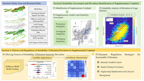
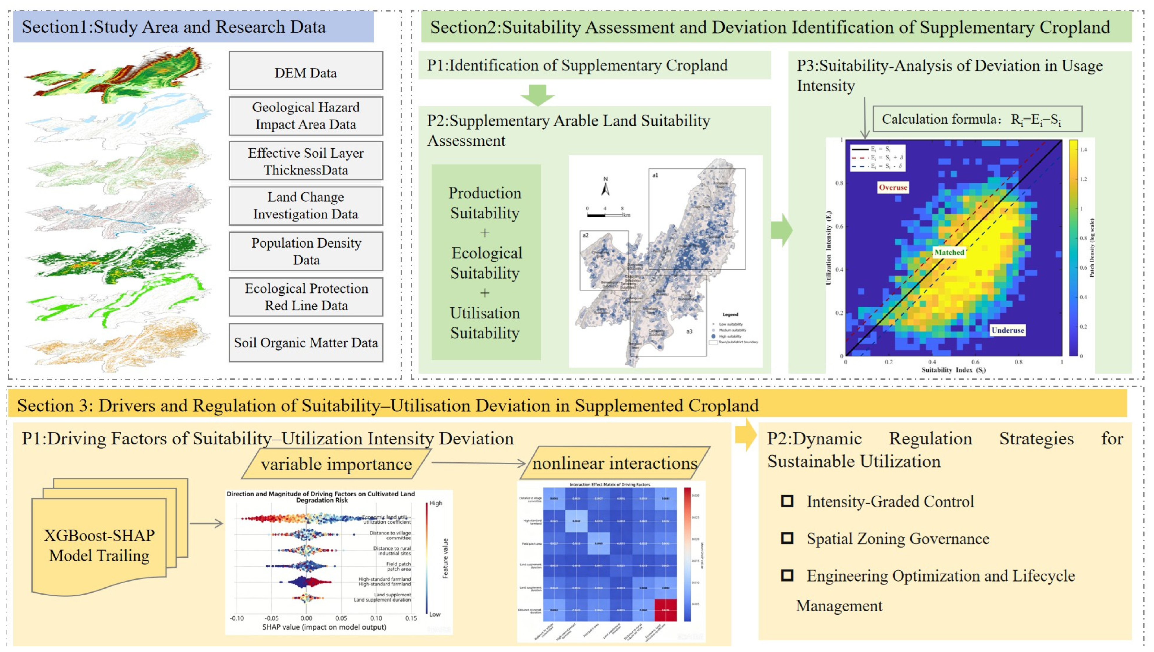
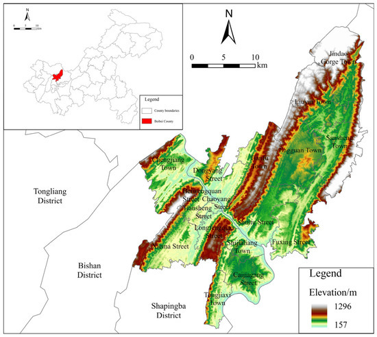
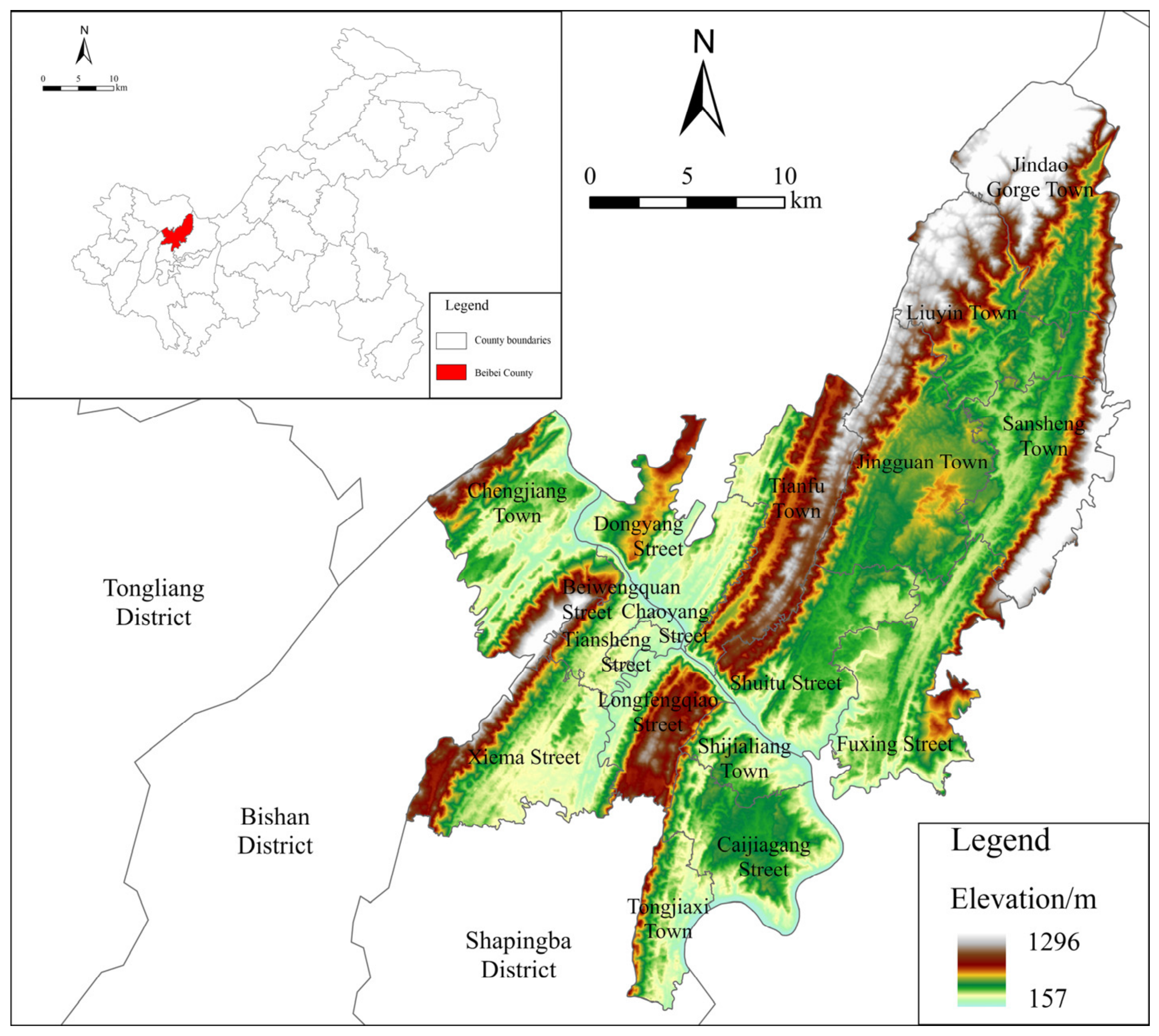
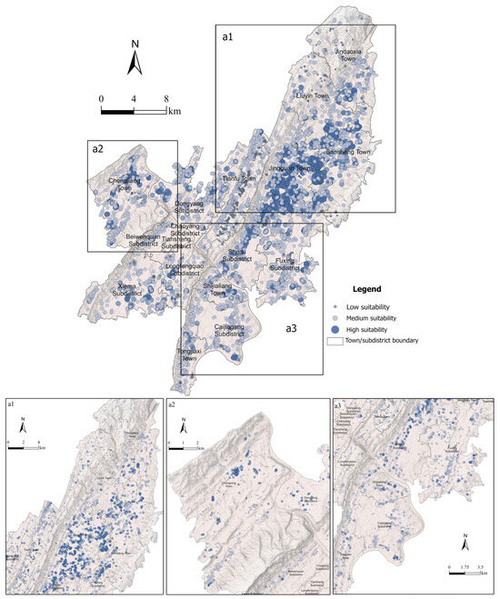
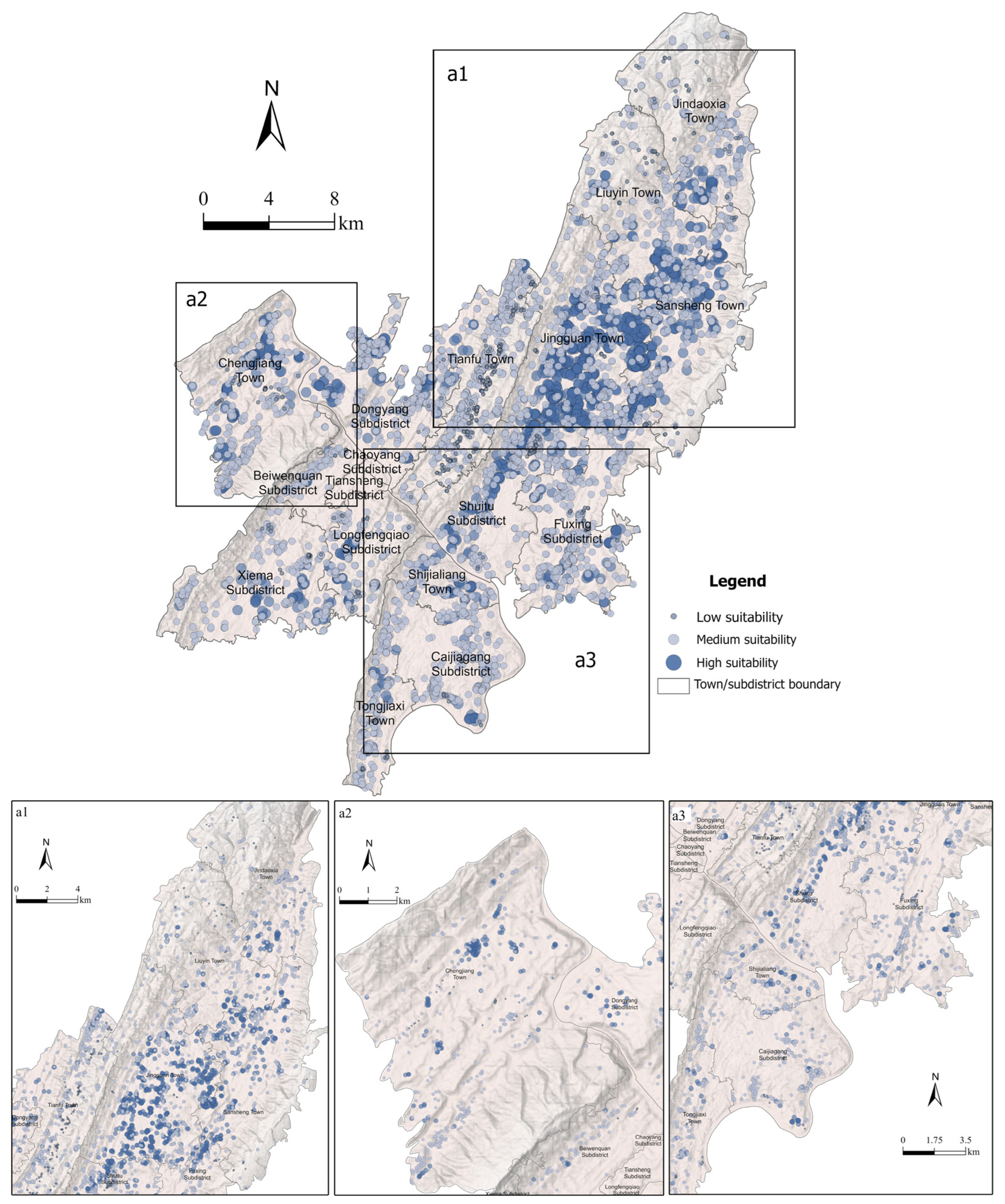
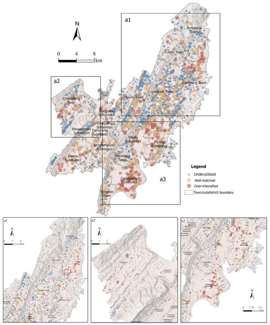
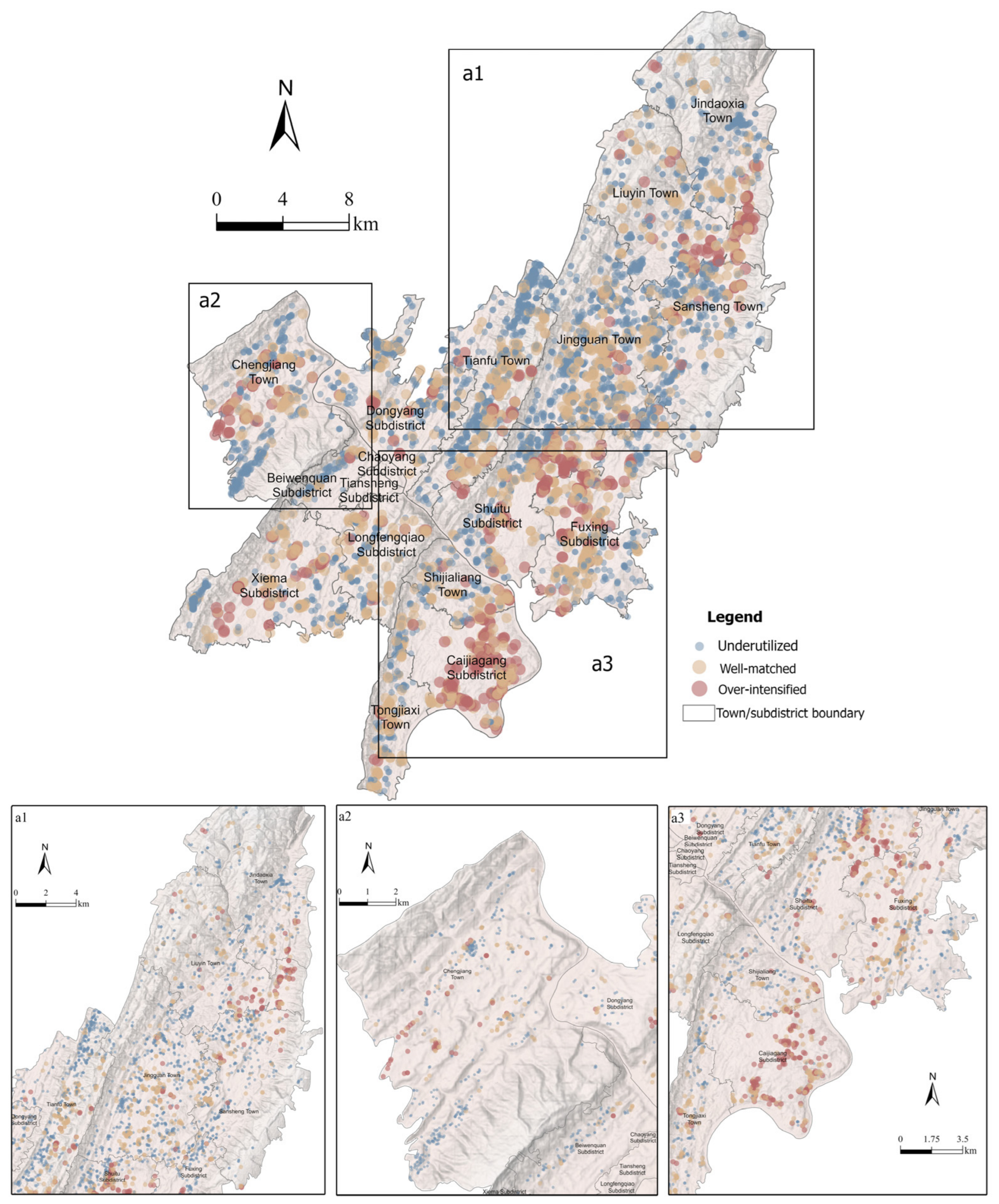
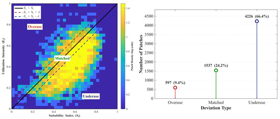
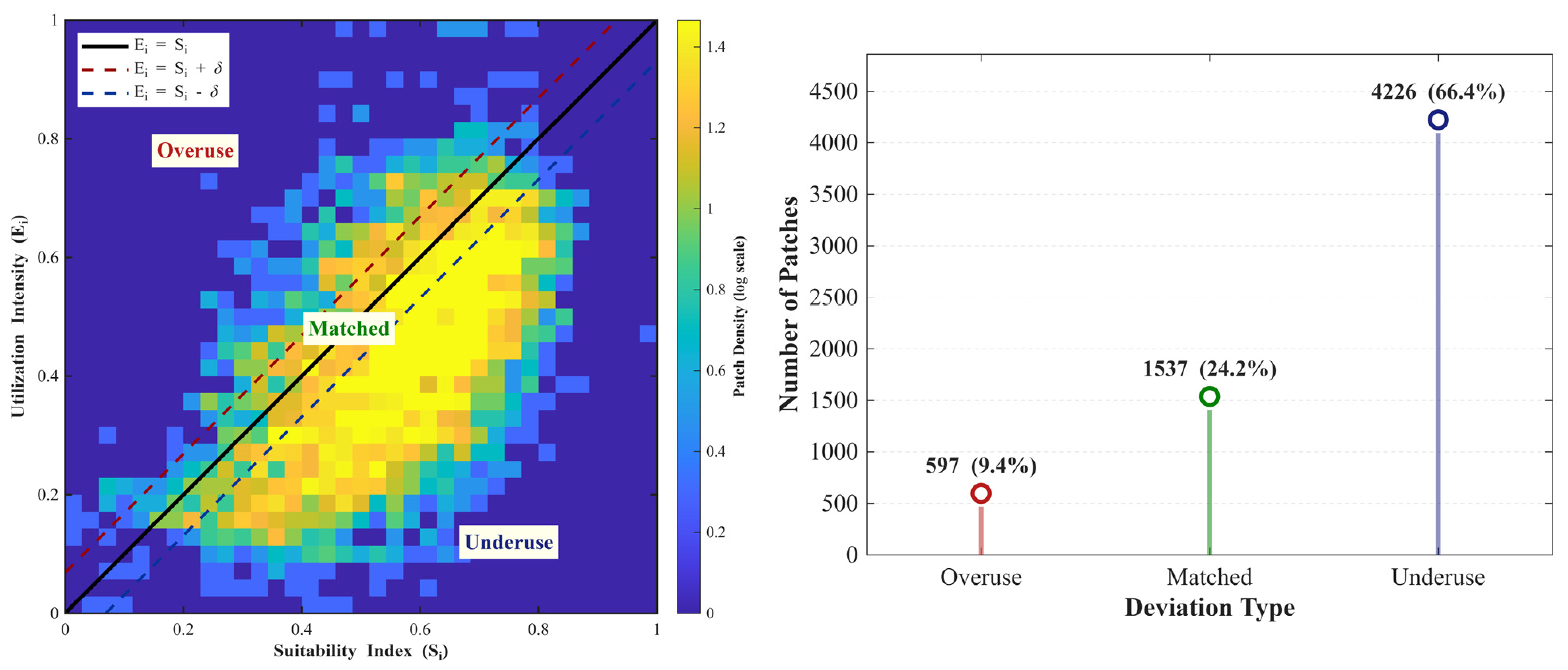
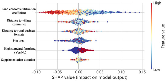
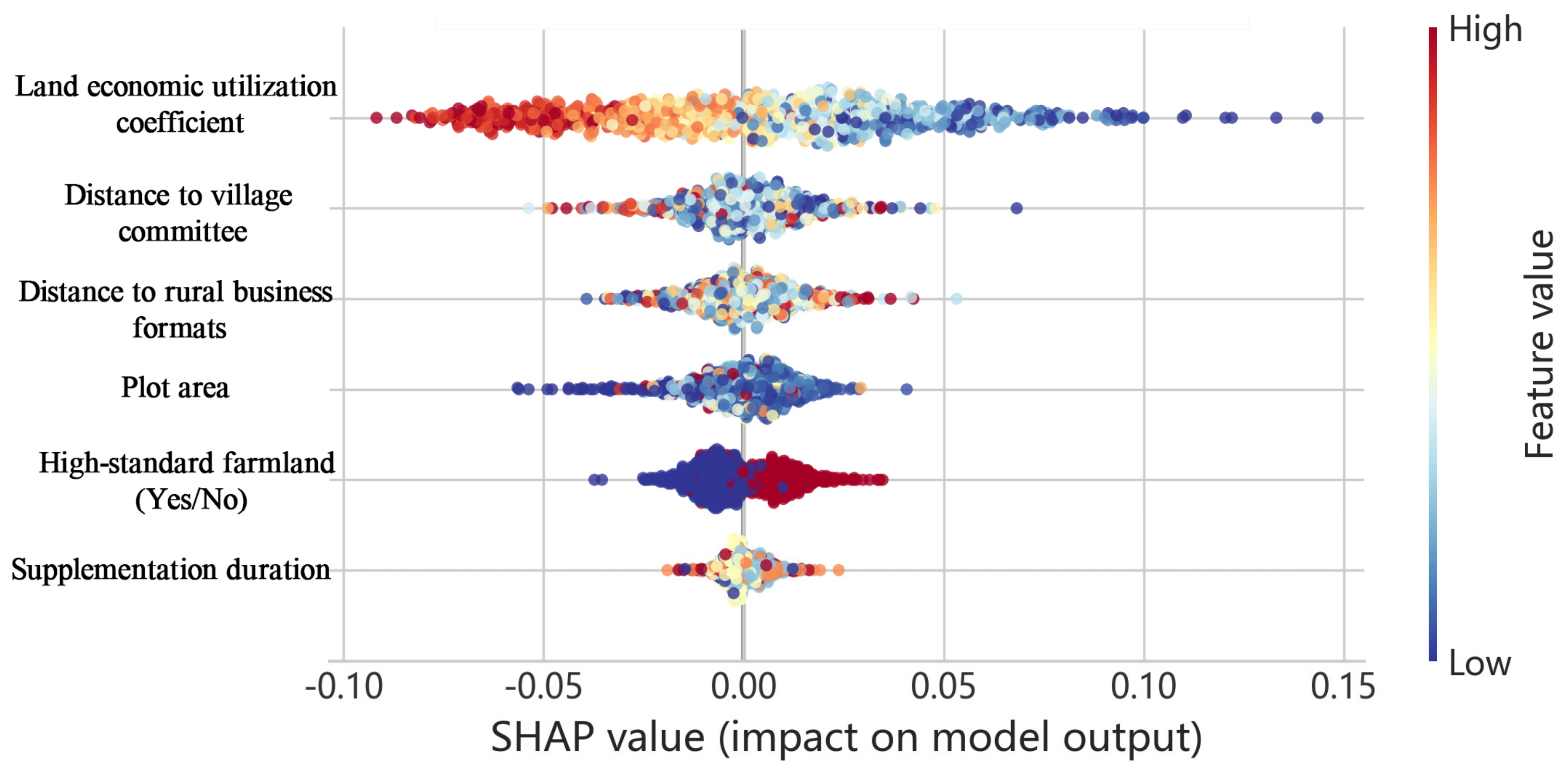
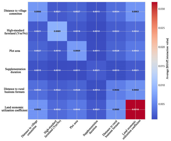
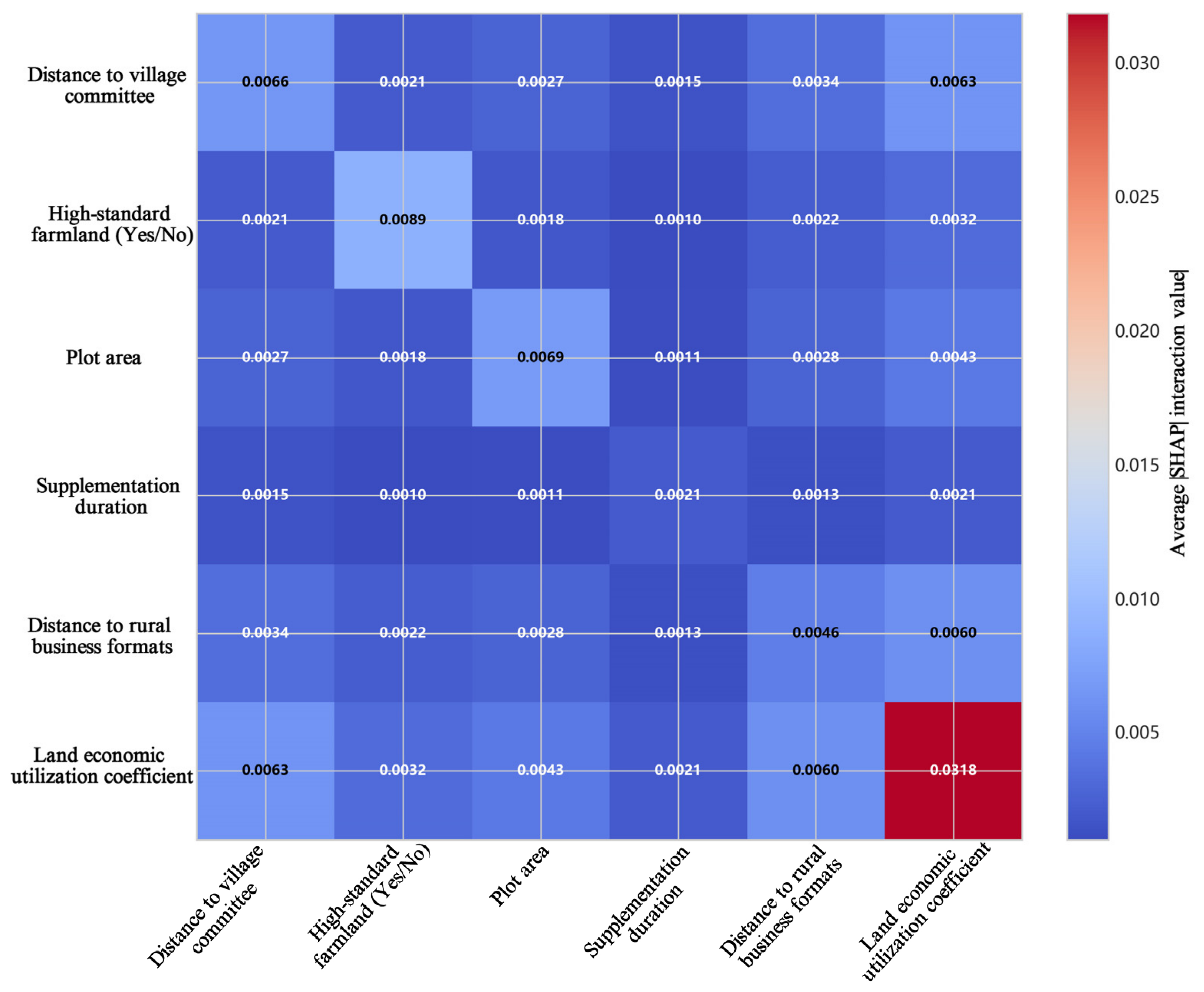

Disclaimer/Publisher’s Note: The statements, opinions and data contained in all publications are solely those of the individual author(s) and contributor(s) and not of MDPI and/or the editor(s). MDPI and/or the editor(s) disclaim responsibility for any injury to people or property resulting from any ideas, methods, instructions or products referred to in the content. |
© 2026 by the authors. Licensee MDPI, Basel, Switzerland. This article is an open access article distributed under the terms and conditions of the Creative Commons Attribution (CC BY) license.