Topic Editors

Department of Geography, University College London, London WC1E 6BT, UK
School of Geographical Sciences, Southwest University, Chongqing 400715, China
Dr. Min Cao
1. School of Earth Sciences, Yunnan University, Kunming 650106, China
2. International Karst Joint Research Center, Yunnan University, Kunming 650106, China
Prof. Dr. Yingbin Feng
School of Public Administration, Guizhou University of Finance and Economics, Guiyang 550031, China

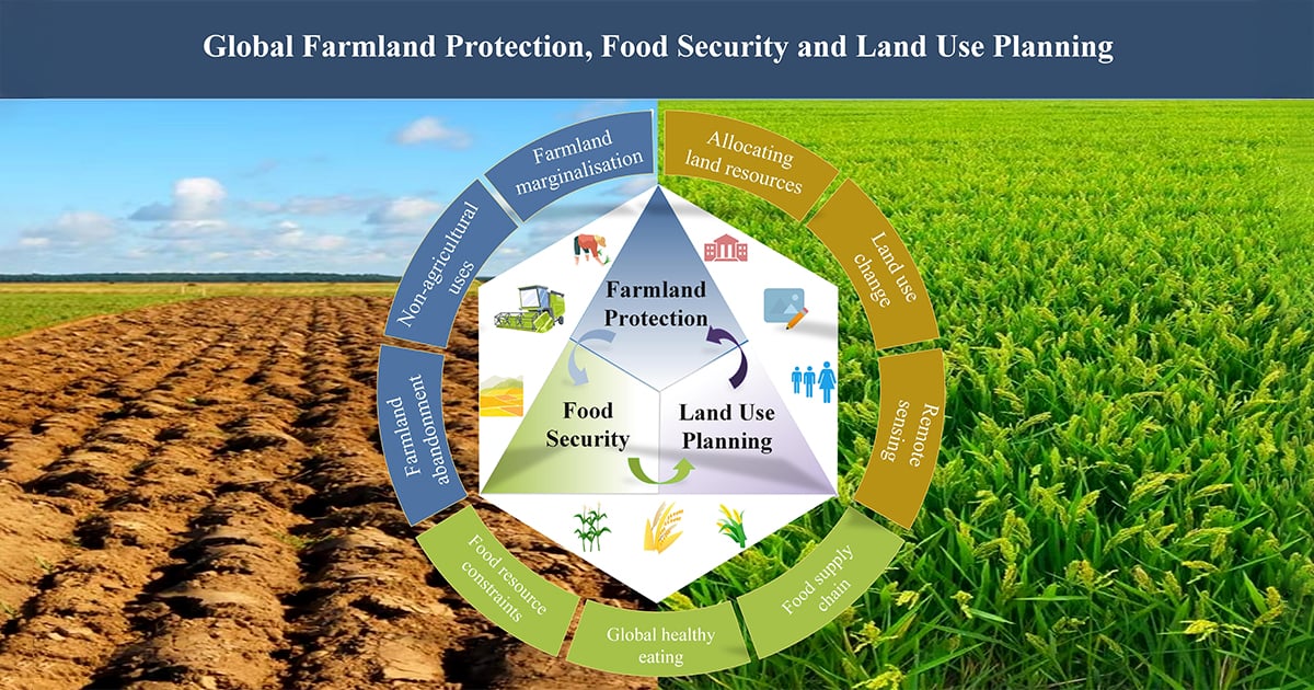
Global Farmland Protection, Food Security and Land Use Planning

Abstract submission deadline
31 December 2025
Manuscript submission deadline
30 June 2026
Viewed by
3532

Topic Information

Dear Colleagues,

Food and grain are fundamental to human survival and development. In today's globalized world, food security is not merely a national or regional concern but a matter of shared human destiny. Farmland is essential for grain production and crucial for ensuring food security. However, in recent years, the phenomena of farmland abandonment, conversion to non-agricultural uses, and production for non-food purposes have become increasingly serious globally. Exacerbated by multiple factors, including the COVID-19 pandemic, regional conflicts, extreme weather events, and trade protectionism, food security faces severe challenges. These factors, compounded by rising inequality, hinder the agricultural food system's ability to provide nutritious, safe, and affordable diets for all. This poses a significant challenge to achieving the Sustainable Development Goal of "zero hunger" (SDG2) by 2030. Statistics show that a vast number of people continue to experience food insecurity and malnutrition, with global hunger levels remaining high for the third consecutive year. In 2023, between 713 million and 757 million people (a median of 733 million) were projected to suffer from undernourishment, representing an increase of approximately 152 million since 2019. Given the current food security challenges, it is imperative to reassess sustainable farmland management practices for crop cultivation to meet future food demands. Land use change and farmland protection are critical factors in ensuring food security and provision. Effective land governance, including well-designed and implemented land use planning, can promote both farmland protection and high-quality land development. Therefore, the rational allocation of land resources and the implementation of differentiated land policies are essential for ensuring food security, optimizing national land use patterns, and achieving sustainable development goals.

This Special Issue seeks to advance the scientific understanding of global farmland conservation, food security and land use planning in the contemporary context. We invite submissions exploring relevant theories, methods, technologies, policies, and practices. We welcome diverse methodological approaches, including quantitative, qualitative, and mixed methods. Submissions may focus on, but are not limited to, the following themes:

  • Land use planning
  • Land use sustainable development
  • Crop growth and remote sensing monitoring
  • Agricultural investment and farmland protection
  • Heavy Metal Pollution and Farmland Protection
  • Human–wildlife Conflict and Farmland Protection
  • Emerging Technologies for Land Use Governance

We look forward to receiving your original research articles and reviews.

Prof. Dr. Debin Lu
Dr. Yahui Wang
Dr. Min Cao
Prof. Dr. Yingbin Feng
Topic Editors

Keywords

  • land use change
  • farmland protection
  • food security
  • land use planning
  • remote sensing 
  • crop modeling

Participating Journals

Journal Name Impact Factor CiteScore Launched Year First Decision (median) APC
Earth
earth
2.1 3.3 2020 23.7 Days CHF 1200 Submit
Land
land
3.2 4.9 2012 16.9 Days CHF 2600 Submit
Sustainability
sustainability
3.3 6.8 2009 19.7 Days CHF 2400 Submit

Preprints.org is a multidisciplinary platform offering a preprint service designed to facilitate the early sharing of your research. It supports and empowers your research journey from the very beginning.

MDPI Topics is collaborating with Preprints.org and has established a direct connection between MDPI journals and the platform. Authors are encouraged to take advantage of this opportunity by posting their preprints at Preprints.org prior to publication:

  1. Share your research immediately: disseminate your ideas prior to publication and establish priority for your work.
  2. Safeguard your intellectual contribution: Protect your ideas with a time-stamped preprint that serves as proof of your research timeline.
  3. Boost visibility and impact: Increase the reach and influence of your research by making it accessible to a global audience.
  4. Gain early feedback: Receive valuable input and insights from peers before submitting to a journal.
  5. Ensure broad indexing: Web of Science (Preprint Citation Index), Google Scholar, Crossref, SHARE, PrePubMed, Scilit and Europe PMC.

Published Papers (7 papers)

Order results
Result details
Journals
Select all
Export citation of selected articles as:
21 pages, 4003 KiB  
Article
Analysis of the Evolution of Non-Agriculturization Arable Land Use Pattern and Its Driving Mechanisms
by Ying Zhang, Qiang Wang, Yueming Hu, Wei Wang and Xiaoyun Mao
Land 2025, 14(5), 968; https://doi.org/10.3390/land14050968 (registering DOI) - 30 Apr 2025
Abstract
Arable land is a crucial natural resource for human survival and development, which supports food production, ecological services, and material–energy cycling. It is not only an important production resource for agriculture but also a key guarantee for ensuring food security and sustainable agricultural [...] Read more.
Arable land is a crucial natural resource for human survival and development, which supports food production, ecological services, and material–energy cycling. It is not only an important production resource for agriculture but also a key guarantee for ensuring food security and sustainable agricultural development. Understanding the current utilization of arable land, exploring the spatial–temporal evolution characteristics, and analyzing the driving mechanisms behind its pattern changes are essential for the rational allocation and sustainable utilization of arable land resources. This study focuses on the utilization of arable land in Guangzhou from 2005 to 2018, employing methods such as statistical analysis and spatial econometrics to provide an in-depth analysis of the spatial–temporal distribution characteristics and driving mechanisms of arable land changes. The results show that from 2005 to 2018, the issue of the conversion of arable land to non-agricultural uses was quite severe in Guangzhou, with the primary form being the conversion of arable land into urban residential construction land. Kernel density analysis revealed that non-agriculturization in Guangzhou exhibited spatial clustering, mainly concentrated in areas with lower elevation. Using standard deviation ellipses and centroid migration analysis, it was found that the center of gravity of non-agriculturization in Guangzhou was generally distributed in a southwest–northeast direction, with a more distinct dispersion compared to the northwest–southeast direction. From 2005 to 2010, the rapid increase in the non-agriculturization rate of arable land in Guangzhou was mainly driven by population density and per capita income, both having a positive impact. From 2010 to 2015, the main driving factor shifted to regional GDP. From 2015 to 2018, regional GDP and the value of the tertiary industry became the main driving factors, but unlike the impact of GDP, the tertiary industry exerted a negative influence on non-agriculturization. Full article
Show Figures

Figure 1

20 pages, 1072 KiB  
Systematic Review
A Systematic Review of Developments in Farmland Cover in Chile: Dynamics and Implications for a Sustainable Future in Land Use
by Fabián Argandoña-Castro and Fernando Peña-Cortés
Sustainability 2025, 17(9), 3905; https://doi.org/10.3390/su17093905 - 26 Apr 2025
Viewed by 246
Abstract
Farmland covers present diverse characteristics, methods, and techniques to monitor and evaluate crops in other geographic areas. This study systematically reviews Land Use/Land Cover Change (LULCC) in agricultural land in Chile through a systematic review of the scientific literature. Using the PRISMA 2020 [...] Read more.
Farmland covers present diverse characteristics, methods, and techniques to monitor and evaluate crops in other geographic areas. This study systematically reviews Land Use/Land Cover Change (LULCC) in agricultural land in Chile through a systematic review of the scientific literature. Using the PRISMA 2020 method, the Web of Science (WOS) database was consulted using the keywords “Landuse”, “Landcover”, “Agriculture”, and “Chile”. We applied six exclusions criteria and constructed a matrix to select relevant aspects, such as title, year of publication, study area and period, methods used, and principal results. In our review, we identified four studies that focused specifically on agricultural land dynamics, mainly in south-central Chile. Chile was selected as the study area due to its geographical diversity, which poses significant challenges for decision-making in land use regulation. These results underscore the need for more spatially informed data on farmland dynamics to inform decision-making, particularly during the alternatives evaluation stage. In this phase, it is essential to assess the impacts on and potential of the territory in order to define suitable economic activities. Although there are numerous studies on LULCC, most emphasize changes in native forests, underscoring the need to address LULCC more comprehensively by considering other land categories, such as agricultural land, shrublands, grasslands, and others. This evidence is crucial for designing practical land management tools and identifying areas that have been extensively studied but lack sufficient research. Full article
Show Figures

Figure 1

22 pages, 2430 KiB  
Article
Evaluation of Arable Land Intensive Utilization and Diagnosis of Obstacle Factors from the Perspective of Public Emergencies: A Case Study of Sichuan Province in China Based on the Pressure-State-Response Model
by Qianyu Zhao, Hao Liu, Peng Zhang, Cailong Deng and Yujiao Li
Land 2025, 14(4), 864; https://doi.org/10.3390/land14040864 - 15 Apr 2025
Viewed by 266
Abstract
Promoting the intensive utilization of arable land is a critical strategy for addressing the scarcity problem of arable land resources and thus ensuring food security. However, public emergencies pose significant challenges to the intensive utilization of arable land. Based on the pressure-state response [...] Read more.
Promoting the intensive utilization of arable land is a critical strategy for addressing the scarcity problem of arable land resources and thus ensuring food security. However, public emergencies pose significant challenges to the intensive utilization of arable land. Based on the pressure-state response (PSR) model and taking Sichuan Province, known as China’s “Heavenly Granary”, as an example, this study constructs a suitable evaluation system and analyzes the variation trend of the intensive utilization of arable land from the perspective of public emergencies. Key factors constraining the intensive utilization of arable land are further analyzed using the obstacle diagnostic model. The findings of this study are as follows: (1) Despite the shocks of public emergencies, the intensive utilization level of arable land in Sichuan Province in China shows an overall upward trend, indicating a high level of resilience and adaptability. (2) The pressure to utilize arable land intensively in Sichuan exhibits periodic fluctuations, yet the state remains generally stable. The whole system shows positive adaptive responses to external pressures and contemporary conditions during the mid-to-late stages of the research period. Nevertheless, coordination among subsystems within the PSR framework remains suboptimal, and a dynamic equilibrium across the subsystems has not yet been achieved. (3) Obstacle factors constraining the intensive arable land utilization in Sichuan exhibit notable temporal variations. Early-period constraints centered on multiple cropping indexes, grain yield per unit area, and irrigation index, reflecting limitations of traditional agricultural production modes. In the later stages, key obstacles shifted to factors including per capita cultivated land, population density, and pesticide/fertilizer input index, highlighting the impediment effects caused by evolving socio-demographic dynamics influenced by public emergencies. The findings of this study reveal critical pathways for local governments to achieve sustainable arable land management amidst global uncertainties. Full article
Show Figures

Figure 1

26 pages, 1377 KiB  
Article
Effectiveness of Agricultural Technology Services on Fertilizer Reduction in Wheat Production in China
by Chenyang Liu, Tiehui Zhu and Ling Xin
Sustainability 2025, 17(7), 2840; https://doi.org/10.3390/su17072840 - 22 Mar 2025
Cited by 1 | Viewed by 329
Abstract
Under the intensifying constraints of resources and environment, reducing fertilizer use while enhancing efficiency in China’s grain production has become imperative. This study empirically analyzes the effect of agricultural technical services on fertilizer reduction in wheat production using 2024 micro-survey data. Agricultural technical [...] Read more.
Under the intensifying constraints of resources and environment, reducing fertilizer use while enhancing efficiency in China’s grain production has become imperative. This study empirically analyzes the effect of agricultural technical services on fertilizer reduction in wheat production using 2024 micro-survey data. Agricultural technical services exert a significantly negative influence on the fertilization intensity among wheat growers. In comparison with non-adopters, adopters achieve a reduction in fertilization amounting to 8.351 kg/mu (equivalent to 125.265 kg/ha) and realize a decrease in chemical fertilizer costs of CNY 26.735/mu (or USD 56.625/ha). Additionally, from the perspective of service components heterogeneity, soil testing, formula fertilization, mechanical fertilization, and straw returning significantly contribute to fertilizer reduction. From the perspective of service model heterogeneity, if farmers participating in market-oriented, cooperative, and industrialized services discontinue participation, their fertilizer application intensity would increase by 5.43%, 7.96%, and 12.79%, respectively. Finally, this study calls on the government to further leverage the technological dissemination advantages of agricultural technology service institutions, guide farmers to reduce the use of chemical fertilizers, so as to accelerate the realization of more sustainable agriculture. Full article
Show Figures

Figure 1

18 pages, 9070 KiB  
Article
Cropping and Transformation Features of Non-Grain Cropland in Mainland China and Policy Implications
by Yizhu Liu, Ge Shen and Tingting He
Land 2025, 14(3), 561; https://doi.org/10.3390/land14030561 - 7 Mar 2025
Viewed by 467
Abstract
The decrease in grain plantation areas poses a growing concern for global food security. China, with its large population, increasingly diversified food demands, and relatively small cultivated lands, has suffered deeply from this phenomenon (non-grain production, NGP) in recent years. Since 2020, the [...] Read more.
The decrease in grain plantation areas poses a growing concern for global food security. China, with its large population, increasingly diversified food demands, and relatively small cultivated lands, has suffered deeply from this phenomenon (non-grain production, NGP) in recent years. Since 2020, the central government of China has claimed to deal with this problem by attracting agriculturalists and organizations involved in grain plantation. In this context, understanding the global NGP of the national situation is vital for policy making. Remote sensing is regarded as the most effective and accurate method for this purpose, but existing studies have mainly focused on algorithms operating at the local scale or exploring grain-producing capability from the perspective of agricultural space. As such, the characterization of NGP on a national scale remains deficient. In this study, we tried to bridge the gap through spatio-analysis with a newly published nationwide crop pattern and land use geo-datasets; the quantitative, spatial, and structural features, as well as the utilization of NGP cropland in the year 2019, were observed. The results showed that about 60% of the cropland was used for non-grain plantation. About 15% of the NGP parcels were cultivated with grains at least three times in the past 4 years, and of these 60% and 40% were parcels with double- or single-season plantation, respectively, which could result in a 16–22% increase in the grain-sown area compared with 2019. Forest and grassland were the dominant non-cropping categories which NGP cropland transferred into, indicating more time and economic cost for regaining grains. NGP parcels also presented spatio-heterogeneity regarding cropping intensity and transformation. Parcels with double-season plantation mostly emerged in northern, central, and southern provinces, while those with single-season plantation were always located in northeastern and western provinces. The parcels that were transferred into forest or grassland mainly appeared in southern and Inner Mongolia, respectively, while the parcels in northern and central areas mostly continued cropping. According to these results, we propose remediation policies focusing on raising the cropping intensity of cultivated land in central and northern provinces due to their advantages of water, heat, terrain, and land use change features. Future work is warranted based on this study’s deficiencies and uncertainties. As a forerunner, this study provides a holistic observation of the NGP phenomenon in mainland China on a national scale, and the findings can inform improvements in land use policies concerning grain production and food security in China. Full article
Show Figures

Figure 1

17 pages, 535 KiB  
Article
How Can the Capability Approach Contribute to a New Perspective on the Value of Cropland Ecosystem Services?
by Yi Tang, Junzhu Liu and Zhoupeng Chen
Land 2025, 14(3), 464; https://doi.org/10.3390/land14030464 - 23 Feb 2025
Viewed by 368
Abstract
Cultivated land ecosystems are complex systems that integrate human activities with natural environments, playing a critical role in both ecological and socio-economic processes. These ecosystems face significant challenges, including land degradation, soil erosion, and biodiversity loss. Despite their importance, there is currently no [...] Read more.
Cultivated land ecosystems are complex systems that integrate human activities with natural environments, playing a critical role in both ecological and socio-economic processes. These ecosystems face significant challenges, including land degradation, soil erosion, and biodiversity loss. Despite their importance, there is currently no standardized conceptual framework or unified approach for valuing cultivated land ecosystems and their ecosystem services. This paper aims to address this gap by developing a comprehensive framework that incorporates the unique characteristics of cultivated land ecosystems, with particular focus on the relationship between ecosystem services and human well-being. It introduces a novel theoretical approach for evaluating these services through the capability approach, emphasizing the integration of key concepts, the clarification of ecosystem service definitions, and the classification of their functions. Furthermore, the study explores the practical applications of this framework for the management and valuation of cultivated land ecosystems. The capability approach, as an innovative solution, is utilized to support and enhance the ecosystem services and benefits provided by cultivated land ecosystems, ultimately contributing to improved social well-being. The findings of this research are crucial for promoting sustainable management practices and advancing the implementation of ecological compensation strategies within the context of cultivated land. Full article
Show Figures

Figure 1

19 pages, 2231 KiB  
Article
Spatial Pattern of Traditional Villages in Remote Mountainous Areas and Their Development Potential Assessment: The Case of Enshi, China
by Fangjie Liu, Wei Xu and Qiang Niu
Sustainability 2025, 17(3), 1138; https://doi.org/10.3390/su17031138 - 30 Jan 2025
Viewed by 764
Abstract
Remote mountainous areas, due to their unique geographical and climatic environments, have ideal conditions for the preservation of traditional villages. However, economic development is also limited as a result. Rationally utilizing traditional village resources to drive economic development in remote mountainous areas is [...] Read more.
Remote mountainous areas, due to their unique geographical and climatic environments, have ideal conditions for the preservation of traditional villages. However, economic development is also limited as a result. Rationally utilizing traditional village resources to drive economic development in remote mountainous areas is a key topic in academic research. This paper explores the spatial pattern and spatial evolution mechanisms of traditional villages in Enshi Prefecture by factor analysis and K-means clustering algorithm. It proposes a preliminary method for evaluating the development potential of traditional villages based on influencing factors of their evolution, considering four aspects: (1) Traditional villages in Enshi Prefecture were mainly formed in the Song, Yuan, Ming, and Qing dynasties. (2) Through the study of the spatial pattern of traditional villages in Enshi Prefecture, water systems, ethnic compositions, road network densities, and national policies have significant impacts. (3) A preliminary assessment of the development potential of traditional villages in Enshi Prefecture shows that there are 25 high-potential villages, 58 medium-potential villages, and 9 low-potential villages. Corresponding construction strategies are proposed for each category. This study revealed the influencing factor of the spatial pattern of traditional villages, underscoring the sustainable development and offering practical guidance for traditional villages in remote mountainous areas. Full article
Show Figures

Figure 1

Back to TopTop