1. Introduction
Sustainable urban mobility has become one of the defining challenges of contemporary urban development. It is generally understood as the capacity to ensure efficient, safe, and inclusive movement of people and goods while reducing negative environmental, social, and spatial impacts [
1,
2]. In coastal and port cities, however, this concept becomes more complex. These cities not only face the everyday demands of their inhabitants but must also respond to pressures arising from maritime trade, port logistics, and seasonal fluctuations in tourism [
3]. In such environments, accessibility becomes a critical element of sustainability, as it determines whether residents, workers, and visitors can effectively use transport networks that are simultaneously efficient, environmentally neutral, and socially inclusive [
4]. At the same time, accessibility can be treated as an indicator of how well existing transport infrastructure is configured and integrated within the urban system.
A growing body of literature highlights the unique position of coastal and port cities in the global mobility debate. Authors such as Maslaric and Gonzalez-Aregall emphasize the need to integrate urban mobility planning with port development strategies to address congestion, emissions, and land-use conflicts. Examples from cities such as the Port of Barcelona show that coordinated strategies that combine freight corridors with robust public and active transport systems can mitigate negative impacts while supporting economic vitality [
5]. These cases also demonstrate that digital tools and intelligent transport systems (ITS) are increasingly important in managing complex transport flows, providing real-time data, and improving user accessibility [
6]. In this context, infrastructure integration and coordination are key factors for improving overall transport system performance [
7,
8].
Recent studies increasingly emphasize the growing role of micromobility systems, including shared bicycles and e-scooters, in supporting sustainable first- and last-mile connectivity in urban areas. At the same time, the effectiveness of micromobility solutions strongly depends on infrastructure quality, route continuity, user safety, and travel comfort. Research indicates that insufficient infrastructure integration and low perceived comfort may significantly reduce the long-term adoption of active and shared mobility modes, particularly in dense urban and waterfront environments [
9,
10].
Gdynia, a medium-sized port city on Poland’s Baltic coast, exemplifies many of these challenges. As a dynamic maritime hub, the city experiences congestion generated by freight movements, port access traffic, and everyday commuting. These pressures are intensified by its compact urban structure, limited land availability for new infrastructure, and the presence of heritage sites that constrain large-scale transport investments. In practice, this means that sustainable mobility strategies in Gdynia must rely on adapting and integrating existing infrastructure rather than constructing entirely new corridors [
11,
12,
13]. At the same time, the city has been proactive in developing strategic frameworks, such as its Sustainable Urban Mobility Plan (SUMP), and in cooperating within the broader Metropolitan Area of Gdańsk–Gdynia–Sopot (OMGGS), which has adopted coordinated mobility strategies for more than 30 municipalities. These initiatives reflect global trends, but their success depends on their translation into local accessibility improvements and tangible infrastructure performance [
1,
14,
15].
The Faculty of Navigation at Gdynia Maritime University provides a useful micro-scale case study of how these broader dynamics play out in practice. The selected case study is particularly relevant because the Faculty of Navigation is located within Gdynia’s waterfront and port-influenced urban structure, where the interaction between tourism, port-related traffic, limited land availability, and multimodal mobility demands shapes transport accessibility. At the same time, the campus is a typical example of a centrally located public institution in a coastal city that remains insufficiently integrated with sustainable transport infrastructure. Therefore, the identified accessibility barriers may also be relevant for other university campuses and public facilities located in waterfront or port-city environments.
Although the faculty is situated on the city’s central waterfront—adjacent to cultural landmarks and maritime attractions—it faces significant accessibility limitations. Public transport stops remain at a considerable walking distance, cycling infrastructure is poorly integrated, and on-campus parking is available only to staff, while municipal parking zones restrict students’ flexibility. Despite its symbolic centrality, the faculty remains relatively disconnected from sustainable transport networks, making it a relevant setting for examining infrastructure-related accessibility barriers in a coastal urban context.
Universities, particularly those in port cities, are also increasingly recognized in the literature as catalysts for mobility transformation. They are not only large traffic generators but also innovation centers that can model and promote sustainable practices. By testing digital mobility platforms, supporting active transport infrastructure, or incentivizing sustainable commuting, universities can influence travel behavior far beyond their campuses. In this sense, Gdynia Maritime University can serve as both a case study and a laboratory for sustainable mobility solutions in the city [
16,
17,
18]. In this context, previous research conducted at Gdynia Maritime University has also highlighted the relevance of employee mobility patterns for institutional sustainability performance. The study, Employee mobility and corporate carbon footprint: a case study at Gdynia Maritime University, demonstrated that commuting behavior constitutes a significant component of the university’s overall environmental impact, underscoring the importance of transport-related factors in organizational sustainability strategies. While that research focused primarily on the carbon footprint dimension, it also indicated that infrastructure configuration and accessibility conditions play a crucial role in shaping mobility choices. The present study builds on these findings by examining infrastructure and accessibility aspects in greater detail, extending the analysis to include both employees and students [
19].
This paper aims to assess infrastructure and accessibility conditions affecting the mobility behaviors of employees and students of the Faculty of Navigation in the context of sustainable urban development in coastal areas. The study focuses on two main objectives: (1) to analyze commuting patterns and the modal split within the academic community, and (2) to identify infrastructure-related barriers to adopting sustainable transport practices, with particular attention to public transport connectivity, active mobility networks, and parking policy. The findings are intended to inform both institutional mobility policies and city-wide infrastructure planning strategies, providing insights into how localized accessibility challenges can shape and be shaped by broader urban mobility systems. Ultimately, this research contributes to understanding how sustainable mobility can be shaped in coastal port cities, where the interplay of spatial constraints, port operations, and urban travel demand demands particularly innovative approaches.
2. Materials and Methods
The research was carried out in May 2025 at the Faculty of Navigation, Gdynia Maritime University. The target group comprised both students and faculty members, making the case study representative of a large academic institution located in a coastal port city. In total, 342 respondents participated in the survey, including 289 students and 53 employees. This ensured that perspectives from both employees and students were represented, enabling a comprehensive assessment of mobility behavior within the faculty. The study formed a separate part of a broader survey conducted across the entire university’s academic community.
Data were collected using an online questionnaire distributed through Microsoft Forms. Participation in the survey was voluntary and anonymous, and respondents were informed of the study’s purpose before providing their answers. The questionnaire included questions on commuting patterns, mode choice, accessibility conditions, and barriers to the use of sustainable transport modes. Particular attention was given to infrastructure-related factors, including public transport connectivity, walking distance to stops, integration of cycling infrastructure, and parking availability.
Responses were exported to Microsoft Excel 2024 PL for further processing. The analysis applied descriptive statistical methods, focusing on modal split, accessibility indicators, and the frequency of transport-related behaviors. In addition, non-parametric statistical methods were applied due to the nominal and ordinal nature of the collected data (including Likert-scale responses). The chi-square test of independence was used to examine relationships between categorical variables, particularly in assessing differences in modal split and the association between travel time and transport mode choice. To assess the strength of the existing relationship, Cramer’s V contingency coefficient, based on the chi-square statistic, was used. The Mann–Whitney U test was used to compare evaluations of transport infrastructure between two independent groups (employees and students). Where applicable, Spearman’s rank correlation coefficient was used to assess relationships between selected variables. All statistical analyses were conducted at a significance level of α = 0.05. Accessibility was assessed primarily through respondents’ reported travel time, perceived infrastructure barriers, and evaluation of local transport facilities. The dataset generated for this research is available upon request from the corresponding author. All statistical calculations were performed in StatSoft/Tibco Statistica 13.3 PL.
The study did not involve any interventionary procedures with human participants; it was based on a voluntary, anonymous questionnaire. Therefore, it did not require formal ethical approval under Polish regulations.
Generative Artificial Intelligence (GenAI) was used in the preparation of this manuscript to assist in text structuring and editing. No GenAI tools were applied in the design of the research, data collection, or analysis stages.
3. Results
The survey conducted among employees and students of the Faculty of Navigation at Gdynia Maritime University provided insight into individual mobility patterns and accessibility challenges within the university environment. In total, 342 valid responses were collected, including 53 from employees and 289 from students. This structure enabled the analysis of both institutional commuting behaviors and students’ daily travel routines.
3.1. Modal Split and Travel Behavior
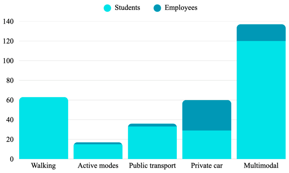
The results show a clear differentiation in the modal split between the two groups (
Figure 1). Among employees, private car use—both as a single mode and within multimodal travel chains—clearly dominates, reflecting the importance of travel time, flexibility, and limited public transport accessibility in reaching the Southern Pier area. Although public transport is used by a smaller group of staff members, active modes such as walking or cycling remain marginal when considered as standalone travel options.
In contrast, students exhibit a more diversified mobility structure. Walking accounts for a significant share of student trips, which can be linked to residence in Gdynia and neighboring municipalities, as well as to shorter travel distances. Public transport also plays an important role in student mobility, both as a single mode and in combination with walking. The relatively high share of multimodal trips among students indicates a greater willingness to combine different modes of transport in daily commuting.
Active modes, including cycling and micromobility use, remain limited in both groups. This pattern suggests that, despite favorable pedestrian conditions, infrastructure-related constraints and weather sensitivity continue to restrict the broader uptake of active mobility.
Similar mobility patterns have also been observed in studies conducted at other Polish universities. In the publication by Romanowska et al., students also support public transport and employees use private cars [
20].
The observed differences in modal split between employees and students were further confirmed by statistical analysis. A chi-square test of independence indicated a statistically significant relationship between respondent status and transport mode choice (
p < 0.05). The biggest differences were observed for private car use, public transport, and walking, confirming that mobility patterns differ systematically between the two groups. No statistically significant differences were observed for active modes, suggesting similar usage patterns across both groups. These results are detailed in
Table 1.
The values of Cramer’s V coefficients for statistically significant relationships indicate a weak relationship in the case of travel by public transport (V = 0.184) and a moderate relationship in the case of travel by foot (0.267) and by private car (0.335).
3.2. Travel Time and Accessibility
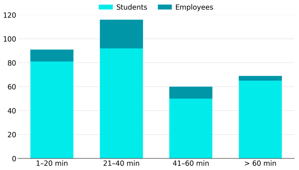
In terms of travel duration, clear differences can be observed between employees and students attending the Faculty of Navigation (
Figure 2). Among students, travel times are most frequently concentrated within the 1–20 min and 21–40 min ranges, indicating relatively good proximity for a substantial share of the student population. At the same time, a noticeable group of students reports travel times exceeding 60 min, reflecting commuting from more distant parts of the metropolitan area.
Employees, in contrast, tend to experience longer commuting times, with a significant proportion of journeys falling within the 21–40 min and 41–60 min intervals. This pattern can be linked to the residential distribution of staff members, many of whom live outside Gdynia, often in suburban or rural areas with weaker public transport connectivity and greater reliance on private car use.
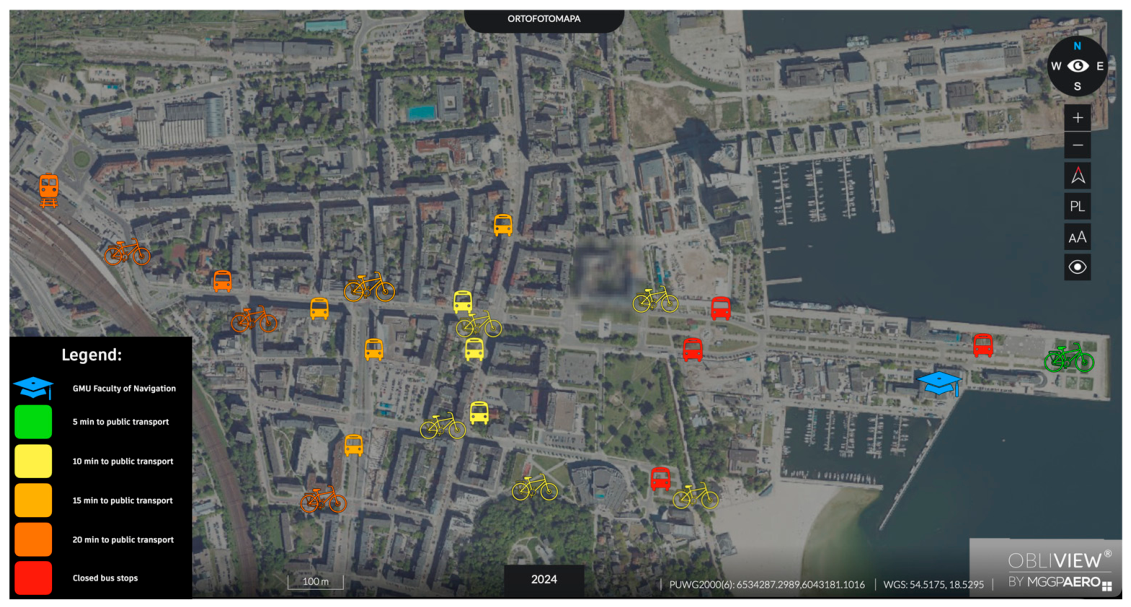
The analysis of access conditions further confirms that, despite the faculty’s central location, transport accessibility remains limited. The nearest bus stop is approximately ten minutes away on foot, while the SKM commuter rail station is about twenty minutes away on foot. Such distances reduce the convenience of public and rail-based travel, particularly during adverse weather conditions, and contribute to longer perceived travel times. Overall, these findings illustrate a typical first- and last-mile accessibility gap, in which the spatial separation between high-capacity transport nodes and the final destination weakens the effectiveness of sustainable transport options.
Statistical analysis also confirmed a significant relationship between travel time and the choice of transport mode. The chi-square test results (
p < 0.05) indicate that longer travel times are associated with a higher probability of private car use. In contrast, shorter travel times are more frequently associated with walking and public transport. This relationship highlights the role of accessibility conditions, particularly distance and travel time, in shaping mobility behavior. No statistically significant relationship was observed for active modes, suggesting that their use is less dependent on travel time and may be influenced by other factors. These results are presented in
Table 2.
The relationships detected in the study, even if statistically significant, are relatively weak. Cramer’s V coefficient values for walking (0.279) and private car travel (0.168) indicate weak relationships. For public transport, the coefficient value of 0.52 indicates a moderately strong relationship.
3.3. Evaluation of Transport Infrastructure
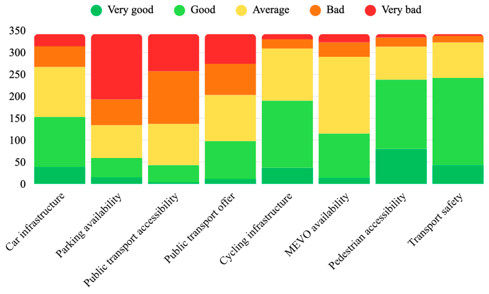
Respondents were asked to evaluate selected elements of transport infrastructure in the vicinity of the Faculty of Navigation using a five-point Likert scale from very good to very bad (
Figure 3). The results reveal differentiated perceptions of infrastructure quality across components.
Pedestrian accessibility and transport safety received the most favorable evaluations, with a clear predominance of good and very good ratings. This indicates that walking conditions in the immediate surroundings of the faculty are generally perceived as comfortable and safe, despite the relatively long distances to major public transport nodes.
In contrast, parking availability and public transport accessibility were assessed most critically. Parking infrastructure recorded the highest share of bad and very bad ratings, reflecting limited parking capacity and restrictive parking regulations that particularly affect students and visitors. Similarly, the accessibility of public transport—understood primarily as distance to stops—was negatively evaluated, confirming earlier findings on first- and last-mile barriers.
A statistical comparison between employees and students was conducted using the Mann–Whitney U test to examine differences in the evaluation of transport infrastructure. The results indicate statistically significant differences (
p < 0.05) for parking availability and car-related infrastructure, with employees generally providing more favorable assessments than students. No statistically significant differences were identified for other infrastructure components, including public transport accessibility, cycling infrastructure, and pedestrian conditions, suggesting that these aspects are perceived similarly across both groups. The detailed results are presented in
Table 3.
The assessment of the public transport offer was more mixed, with average and good ratings dominating, suggesting that its spatial integration with the campus is the main limitation, rather than the quality of service itself. Cycling infrastructure and the availability of Mevo bike-sharing stations were generally rated average to good, indicating a basic level of provision but with clear potential for improvement. The relatively high share of average ratings in these categories points to insufficient network continuity and limited integration with the main pedestrian access routes leading to the faculty.
Overall, the evaluation highlights a clear contrast between well-performing pedestrian-oriented infrastructure and weaker integration of motorized and shared mobility systems. This imbalance reinforces car dependency among employees and impedes the wider adoption of sustainable transport modes, despite the faculty’s central urban location.
3.4. Barriers to Sustainable Mobility
The analysis of open-ended responses identified several recurring barriers limiting the adoption of sustainable transport modes among employees and students attending the Faculty of Navigation. The most frequently reported barriers concern public transport accessibility and parking conditions, reflecting both spatial and organizational constraints at the Southern Pier location.
As shown in
Table 4, the lack of direct public transport connections to the faculty building was the most commonly indicated barrier, particularly among students. This was closely followed by the distance to public transport stops, which further weakens the attractiveness of bus and rail-based travel, especially under adverse weather conditions. High parking costs in surrounding municipal zones also emerged as a significant barrier, predominantly affecting students, while employees more frequently referred to traffic congestion and travel time reliability.
Barriers related to cycling infrastructure and shared mobility systems, including the limited number and suboptimal placement of bicycle-sharing stations, were reported less frequently but remain relevant to improving first- and last-mile connectivity. Weather conditions were identified as an additional factor influencing daily travel choices, particularly discouraging the use of active transport modes.
Overall, the results indicate that barriers to sustainable mobility at the Faculty of Navigation arise from a combination of infrastructural deficiencies, spatial separation from major transport nodes, and regulatory constraints. Importantly, the relative importance of these barriers differs between employees and students, underscoring the need for differentiated and targeted accessibility measures.
These findings are consistent with the statistical results presented above, confirming that infrastructure-related constraints are experienced unevenly by different user groups.
3.5. Summary of Findings
The spatial context of the identified accessibility challenges is illustrated in
Figure 4. The map shows the location of the Faculty of Navigation relative to the Southern Pier area, nearby bus stops, the SKM commuter rail station, and Mevo bicycle stations, along with approximate pedestrian access distances. The spatial layout clearly demonstrates that, despite its central urban position, the faculty remains physically separated from the nearest active public transport nodes by walking distances that reduce the attractiveness of collective and rail-based modes.
The results indicate that accessibility constraints are not the consequence of peripheral location but rather of limited multimodal integration. The distance to bus and rail services, the lack of direct public transport serving the Southern Pier area, insufficient continuity of cycling infrastructure, and restricted on-campus parking collectively shape a mobility environment that structurally favors private car use, particularly among employees commuting from outside Gdynia. These conclusions are further supported by statistical analysis, which confirmed that both transport mode choice and infrastructure perception differ significantly between user groups and are closely related to accessibility conditions.
This configuration reveals a first- and last-mile accessibility gap between the faculty’s central position and its effective integration into the broader multimodal transport network. Addressing this gap requires targeted infrastructure interventions, including improved pedestrian connectivity to the SKM station, the reorganization or extension of public transport routes serving the Southern Pier, and the strategic relocation or expansion of Mevo bicycle stations along the main access corridors.
However, the survey results also show that employees and students experience accessibility challenges differently, highlighting the need for differentiated policy responses. While employees—many of whom commute from suburban or rural areas—require stronger intermodal connectivity and more effective parking management solutions, students would primarily benefit from improved public transport integration and better infrastructure supporting active mobility. Consequently, enhancing accessibility in this context should not rely on uniform measures but rather on a coordinated set of infrastructure and policy instruments tailored to distinct user groups. Such an approach would not only reduce structural barriers to sustainable mobility but also align institutional-level interventions with Gdynia’s Sustainable Urban Mobility Plan (SUMP) and the city’s broader sustainability objectives.
4. Discussion
The results of this study demonstrate that transport accessibility should be understood not merely as a matter of individual convenience but as a structural condition shaping the performance and transformation potential of urban transport systems. In the context of smart and sustainable infrastructure development, accessibility determines whether low-emission and shared transport modes can effectively compete with private car use. The case of the Faculty of Navigation at Gdynia Maritime University shows that even centrally located facilities may remain functionally disconnected from sustainable mobility systems when first- and last-mile accessibility is insufficient. This observation is consistent with previous studies conducted in the port city of Gdynia, which emphasize that spatial proximity alone does not guarantee effective integration into sustainable transport networks [
15,
16]. This interpretation is further supported by the statistical results presented in
Section 3, which confirm significant differences in mobility patterns between user groups under different accessibility conditions.
The identified accessibility limitations highlight how infrastructure gaps can undermine the effectiveness of otherwise well-developed transport systems. Despite the presence of public transport services and shared mobility solutions in the wider urban area, their limited spatial integration with the Southern Pier reduces their usability and overall attractiveness. This situation reinforces car dependency, particularly among employees commuting from outside the city. The statistical results further confirm that longer travel times are significantly associated with increased reliance on private car use, indicating that infrastructural and spatial barriers directly translate into behavioral outcomes. Similar patterns have been reported in other port-city contexts, where insufficient coordination between port-related areas and urban public transport networks has been shown to limit the potential for modal shift and prolong car-oriented travel behavior [
13,
21,
22,
23]. Beyond travel time and physical accessibility, the attractiveness of sustainable mobility options is also influenced by environmental comfort factors, including noise exposure, perceived safety, and route quality. In port-city environments, where freight traffic and tourist flows intensify traffic pressure, these qualitative conditions may significantly affect the willingness to use active and shared mobility modes. Previous studies indicate that lower noise levels and improved travel comfort positively influence the perceived attractiveness of sustainable urban transport infrastructure [
24,
25,
26]. From the perspective of transport decarbonization, such infrastructure-induced behavioral patterns constitute a critical barrier, as the transition toward lower-emission mobility systems depends not only on technological advancements but also on the availability, continuity, and usability of non-car alternatives [
27,
28].
The findings further emphasize the importance of first- and last-mile connectivity as a key component of smart transport infrastructure. Intelligent transport systems, digital mobility platforms, and shared mobility services rely on physical accessibility to deliver system-level benefits. Where pedestrian routes, cycling infrastructure, and public transport access points are poorly connected, the potential of smart solutions remains underutilized. This confirms earlier research indicating that digitalization and ITS deployment alone cannot compensate for infrastructural discontinuities and must be supported by coherent physical networks to achieve meaningful sustainability outcomes [
29,
30,
31].
Universities, particularly those located in port cities, occupy a unique position within urban transport systems. As major traffic generators, they significantly influence daily mobility patterns while also serving as innovation hubs that can pilot smart, sustainable solutions. The case of Gdynia Maritime University illustrates how academic institutions can function as diagnostic sites for identifying systemic infrastructure weaknesses. Previous university-based mobility studies similarly highlight the role of campuses as effective laboratories for testing integrated infrastructure measures, mobility management strategies, and data-driven planning approaches [
1,
14,
20,
32]. The observed differences between employees and students further suggest that accessibility challenges are not uniform, reinforcing the need for user-sensitive approaches in mobility planning and infrastructure design. This is further supported by statistical evidence showing significant differences in both modal split and the perception of selected infrastructure elements between these groups.
From a planning perspective, the results underscore the need to integrate local accessibility assessments into broader strategic frameworks, such as Sustainable Urban Mobility Plans. While Gdynia and the wider Metropolitan Area of Gdańsk–Gdynia–Sopot have adopted strategic mobility objectives aligned with sustainability principles, their effectiveness ultimately depends on implementation at the micro-scale. The findings align with the multilevel transport planning literature, which stresses that strategic goals related to sustainable and smart infrastructure must be translated into location-specific interventions that address concrete accessibility barriers [
1,
14,
33]. The identified relationships between accessibility conditions and mobility choices, confirmed by statistical analysis, reinforce the need to address infrastructure gaps at the local scale as a prerequisite for effective system-level interventions.
The study also highlights the value of behavioral and perceptual data as inputs for smart infrastructure planning. Survey-based insights into travel behavior and perceived accessibility barriers provide valuable information for prioritizing infrastructure investments and designing targeted interventions. As emphasized in recent transport planning research, user-oriented data play a crucial role in identifying hidden infrastructural bottlenecks and supporting evidence-based decisions aimed at reducing car dependency [
34,
35]. Rather than focusing solely on emissions metrics, this approach emphasizes the enabling conditions necessary for long-term behavioral change.
The study has several limitations that should be acknowledged. First, the analysis is based on self-reported survey data collected within a single academic institution, which may limit the direct transferability of results to other urban contexts. Second, the research focuses primarily on perceived accessibility and travel behavior rather than on real-time mobility data, GPS tracking, or transport system simulations. Nevertheless, the presented approach provides valuable insight into how localized infrastructure conditions shape sustainable mobility choices in coastal and port-city environments.
Future research could extend the analysis by integrating GIS-based accessibility modeling, real-time mobility datasets, transport flow data, or scenario-based simulations of infrastructure interventions. In particular, the application of spatial accessibility models, discrete choice approaches, or data-driven mobility analyses could support a more detailed assessment of how specific infrastructure changes—such as new public transport stops, shared mobility stations, or pedestrian connections—may influence modal shift and sustainable travel behavior. Further studies may also explore integrating smart mobility platforms and digital transport management tools to improve first- and last-mile connectivity in coastal urban environments.
Overall, the discussion confirms that sustainable and smart transport infrastructure development in coastal and port cities requires a holistic understanding of accessibility as a system-level property. Addressing first- and last-mile gaps, improving multimodal integration, and aligning infrastructure provision with user needs are essential steps toward creating transport systems capable of supporting decarbonization goals. The presented case study contributes to this perspective by empirically confirming arguments widely discussed in the literature, demonstrating how localized accessibility constraints reflect broader structural challenges relevant to smart and sustainable infrastructure transitions.
5. Conclusions
This study demonstrates that transport accessibility constitutes a fundamental enabling condition for the development of smart and sustainable transport infrastructure, particularly in coastal and port cities characterized by spatial constraints and competing land-use functions. The case of the Faculty of Navigation at Gdynia Maritime University confirms that central urban location alone does not guarantee effective accessibility and that deficiencies in first- and last-mile connectivity can significantly undermine the performance of public transport and shared mobility systems.
The empirical findings, supported by statistical analysis, highlight that infrastructural and organizational barriers—such as the lack of direct public transport connections, long walking distances to major transport nodes, limited continuity of cycling infrastructure, and restrictive parking conditions—shape daily mobility behavior and reinforce private car dependency. Importantly, these barriers are experienced differently by employees and students, indicating that uniform solutions are insufficient and that accessibility policies must account for diverse user needs and travel patterns.
From the perspective of smart and sustainable infrastructure, the results emphasize that digital tools, intelligent transport systems, and shared mobility solutions cannot deliver their full potential without coherent physical integration. This is consistent with the statistically confirmed relationships between accessibility conditions and transport mode choice identified in this study. Accessibility gaps at the micro-scale undermine system-level efficiency and hinder the transition to low-emission transport modes, even in cities with advanced strategic planning frameworks. Consequently, infrastructure continuity and multimodal integration should be treated as priority components of decarbonized transport systems.
The study further underlines the strategic role of universities as both major traffic generators and potential laboratories for mobility innovation. University campuses located in port and waterfront areas offer valuable opportunities to test integrated infrastructure solutions, mobility management measures, and data-driven planning approaches aligned with Sustainable Urban Mobility Plans. In this context, local accessibility assessments can provide essential input for aligning institutional initiatives with city-wide sustainability objectives.
Overall, the presented case study contributes to the broader debate on smart and sustainable transport infrastructure by demonstrating how localized accessibility challenges reflect broader systemic barriers to sustainable mobility transitions. While infrastructure accessibility and modal integration constitute important preconditions for behavioural change, the transition towards low-carbon mobility also depends on the deployment of energy-efficient transport technologies, including advanced public transport systems and low-emission vehicle fleets, as demonstrated in previous research on energy consumption in urban transport systems [
36,
37]. Addressing first- and last-mile gaps, strengthening multimodal integration, and tailoring infrastructure interventions to specific user groups emerge as key steps toward creating more resilient and sustainable transport systems in coastal and port cities. The findings also highlight the importance of integrating accessibility-oriented infrastructure planning into broader smart mobility and urban sustainability strategies.
From a wider policy perspective, the presented results support the objectives of the European Green Deal and the UN 2030 Agenda by emphasizing the role of integrated, low-carbon, and accessibility-oriented transport systems. Improving first- and last-mile connectivity in coastal and port cities may therefore constitute an important step toward achieving more resilient, inclusive, and climate-neutral urban mobility systems.