


Abstract
This study evaluates publicness and spatial quality along the Çoruh Riverfront in the city center of Bayburt through the Project for Public Spaces (PPS) framework. The research is based on a literature review, interpretation of satellite imagery, on-site observation, production of visual documentation, and surveys conducted with a total of 210 participants, including 30 users in each of seven public spaces. The findings show that the presence of parks along the riverfront alone does not produce continuous and inclusive public life. In the composite PPS index, July 15 Martyrs Park showed the strongest profile (63.4%), whereas the surroundings of Kıyasi Şentürk Mosque showed the most vulnerable profile (44.1%). The mean values indicate that Access and Linkages are relatively strong (62.5%), whereas Comfort and Image constitute the weakest dimension (46.2%). This result suggests that although the Çoruh Riverfront is physically accessible, it has difficulty producing continuity in terms of staying, shade, orientation, maintenance, safety, and inclusive social programming. The study argues that, in small-scale Anatolian cities, riverfronts should be planned not as fragmented recreational areas but as accessible, socially inclusive, and ecologically sensitive blue-green public spines. Therefore, this study does not use PPS merely as a scoring tool. It uses it as a placemaking framework that makes it possible to read public continuity, place-led management, and social-ecological sustainability together on small-city riverfronts. The findings are interpreted as exploratory and diagnostic evidence for planning and design, rather than as inferential statistical proof of site-level differences or direct ecological performance.
1. Introduction
Urban sustainability cannot be explained from a narrow perspective solely through land-use balance, transportation infrastructure, or indicators of economic development. The everyday life of the city, the extent to which different user groups can come together, and the spatial qualities that support shared life are fundamental components of sustainable urbanization. Therefore, public spaces are not physical voids or passive open areas. They are places where social relations are produced, urban identity becomes visible, and quality of life is tested at the everyday scale [1,2,3,4,5,6,7].
Waterfronts occupy a particular place in this discussion. River, lake, and sea waterfronts have historically played a decisive role in the development of urban settlements through functions such as transportation, production, defense, agriculture, trade, and cultural representation. Today, in addition to these historical functions, waterfronts have gained importance in terms of blue-green infrastructure, climate adaptation, recreation, urban image, social interaction, and ecological continuity [8,9,10,11,12,13,14,15,16,17,18,19,20,21,22]. However, waterfronts also risk losing their public character because of fragmented management processes, rent pressure, motor-vehicle-oriented road systems, and engineering-centered flood-control approaches.
In this context, waterfront publicness is not merely a local design issue. It is also a sustainability indicator related to Target 11.7 of the United Nations Sustainable Development Goals, under Goal 11, “Sustainable Cities and Communities,” which aims to provide “universal access to safe, inclusive and accessible, green and public spaces” [23]. Therefore, quality analysis on riverfronts should go beyond the quantity of green space and read together indicators of access equity, social encounter, health, maintenance, and climate adaptation [24,25,26].
In Türkiye, the public character of waterfronts is emphasized at the legal level. However, in everyday use, this publicness does not always take part in urban life. In particular, inner-city riverfronts can become weak public spaces through residential fabric, vehicular roads, irregular recreational areas, fragmented green spaces, or structures transformed into concrete channels. This situation requires reassessing the relationship between the waterfront and the city. Such an assessment should not be based only on physical proximity, but also on access, diversity of use, spatial quality, and social inclusiveness [15,16,17,18].
The focus of this study, the Bayburt Çoruh River, is one of the rivers that divide the city center and, in other words, directly contact the city. The river is a defining element in the city’s morphological development, its relationship with the natural environment, and its urban image. Nevertheless, the river has been transformed into a concrete channel. Its banks have been shaped in some places by vehicular roads and development pressure, and in others by disconnected park areas. Accordingly, the main assumption of the study is that although the Çoruh River physically passes through the city center, it cannot form an integrated waterfront spine in terms of public space quality.
Based on this assumption, the study seeks answers to four research questions: (i) To what extent do the spaces along the Bayburt Çoruh Riverfront respond to users’ everyday needs and expectations for public interaction? (ii) What is the level of public continuity and accessibility along the waterfront? (iii) What scope do the examined spaces provide in terms of the four main quality dimensions of the PPS approach? (iv) What kind of design and management approach is required to transform the Çoruh Riverfront into a sustainable and inclusive public spine?
The original contribution of the study can be defined at three levels. First, it advances a discussion that makes riverfront publicness visible in a small-scale Anatolian city. Providing a scale-complementary example to a literature that mostly focuses on metropolitan waterfronts strengthens this discussion. Second, it addresses PPS-based indicators through a hybrid approach. This hybrid approach, which combines user responses, field observations, and spatial interpretations, discusses the impact of design decisions on everyday experience. Third, it discusses the need not to treat waterfronts merely as recreation or landscape-design areas. Instead, it frames the issue as an urban infrastructure matter related to social sustainability, ecological sensitivity, pedestrian continuity, inclusive access, and integrated management.
In this revised framing, the riverfront is also understood as a dynamic territorial interface rather than a fixed linear open-space sequence. This interpretation is consistent with the notion of the waterfront as a “fluid territory”, which emphasizes the changing relationship among publicness, spatial continuity, governance, urban development, and water systems [27].
In this direction, the main argument of the study is that the primary problem along the Çoruh Riverfront is not only a lack of access. It is also important that, in accessible spaces, the quality of socializing, comfort, orientation, maintenance, and safe engagement with water does not show continuity along the waterfront. This argument moves the article beyond an assessment of individual parks toward a transferable evaluation framework for measuring riverfront publicness in small cities.
This contribution is related to an interdisciplinary perspective that treats sustainability as technical, environmental, cultural, economic, and social. The study evaluates small-city riverfronts not merely as open-space or recreation issues, but together with access equity, social inclusiveness, blue-green infrastructure performance, and long-term management continuity [22,23,28,29,30].
2. Conceptual Framework: Publicness, Riverfront Quality, and Sustainability
Public space is a multidimensional concept situated at the intersection of urban planning, urban design, and landscape architecture. From the perspective of planning and design, public space refers to physical areas that can be accessed, used, and endowed with meaning by different segments of society. However, the fact that an area is under public ownership does not mean that it is experienced as truly public. Publicness is produced together with the right of access, diversity of use, safety, social encounter, representation, belonging, and forms of management [3,4].
Public space quality cannot be read only through physical arrangement or public ownership. Quality should be evaluated together with user needs, everyday activities, and the willingness to stay in a place. Carmona et al. associated public space with social interaction, economic vitality, environmental improvement, and the production of urban identity. Carr et al. emphasized relaxation, passive/active engagement, discovery, belonging, and democratic access. Like both approaches, Gehl’s distinction among necessary, optional, and social activities provides a theoretical basis for the PPS-based evaluation in this study [2,3,6,7].
Within this framework, the Çoruh Riverfront should not be evaluated only through the presence of open space. It should be read through indicators of everyday public life, such as encounters among different user groups, length of stay, visual/physical contact with water, pedestrian continuity, comfort, maintenance, and perceived safety.
The Project for Public Spaces (PPS) approach offers a practical framework for evaluating successful public spaces through four core dimensions. These are Access and Linkages, Comfort and Image, Uses and Activities, and Sociability [20,21]. In summary, Access and Linkages include visibility, walkability, physical continuity, and connection to the surrounding urban fabric. Comfort and Image are related to perceived safety, cleanliness, seating opportunities, shade, maintenance, attractiveness, and identity. Uses and Activities indicate whether the space is used repeatedly and in diverse ways by different user groups at different times. Sociability is the capacity of the space to generate encounters, co-presence, belonging, and shared public life. Here, the PPS framework is not used as a normative “scoring race.” It is used as a comparative design tool that helps diagnose repeated spatial thresholds, comfort gaps, and differences in social use along the waterfront. Thus, it becomes possible to understand that high access values do not always produce high publicness. Conversely, it can be tested whether accessible but uncomfortable or unprogrammed areas become merely passage corridors.
Although PPS is useful for translating public-space quality into observable and user-oriented criteria, it also has limitations. It can underrepresent ownership regimes, formal and informal control mechanisms, public–private thresholds, network configuration, and actual behavioral patterns when it is used alone. For this reason, publicness assessment is increasingly discussed through multiple and sometimes competing frameworks. Varna and Tiesdell’s Star Model of Publicness, for example, evaluates publicness through ownership, control, civility, physical configuration, and animation [31]. Space Syntax approaches, by contrast, focus on spatial integration, route choice, and the configurational accessibility of urban networks [32]. Behavioral mapping and direct observation traditions emphasize what users actually do in space, where they stay, how they move, and how social encounters emerge over time [6,20].
This study, therefore, positions PPS as a practical diagnostic framework rather than as a complete theory of publicness. Its strength lies in connecting user perception, field observation, and design-oriented interpretation; its weakness is that it does not fully measure institutional control, spatial network centrality, or observed behavior over extended time periods. The Çoruh Riverfront is evaluated within this limitation, and the PPS results are interpreted together with spatial observations on continuity, barriers, maintenance, and the relationship between parks and the river.
In this study, the PPS approach is not treated only as a four-dimensional indicator matrix. It is treated as a placemaking approach that centers the continuity of maintenance, programming, and management, as well as the everyday experience of the place’s users [33,34,35,36,37]. Therefore, the PPS indicators were not intended to produce a final “success ranking” in the research. Rather, they were used as diagnostic tools that made visible which spatial thresholds, comfort gaps, and deficiencies in social use along the waterfront should be prioritized for intervention.
PPS’s “successful place” approach establishes a mutual relationship among accessibility, diversity of use, comfort/image, and sociability. This relationship should be read together with the SDG 11.7 target of safe, inclusive, accessible, green, and public spaces. Such a combined reading requires the riverfront to be addressed not merely as a recreational area but as a social-ecological infrastructure that produces social encounter, climatic comfort, public belonging, and ecological awareness.
This socio-ecological reading also requires a territorial interpretation of waterfronts. Costa, Andrade, and Dal Cin conceptualize the waterfront as a “fluid territory”, stressing that waterfront transformation should be understood through mutable relations between land and water, public use, planning decisions, governance arrangements, and changing urban economies [27]. From this perspective, the riverfront is not simply a recreational corridor or a sequence of parks; it is an evolving interface where ecological processes, mobility networks, public-space practices, and development pressures continuously interact.
Urban riverfronts add ecological and spatial dimensions to public space evaluation. Riverfronts form a threshold between land and water. They therefore carry, simultaneously, the functions of recreation, ecology, flood management, cultural representation, and movement continuity. When well designed, a waterfront provides opportunities for everyday contact with water, continuous movement, participation in social activities, and experience of urban nature. When poorly designed, it turns into residual areas between concrete channels, vehicular roads, barriers, or fragmented development, or into disconnected parks.
Accordingly, the Çoruh Riverfront is approached in this study as both a public-space system and a fluid territorial structure. This addition strengthens the theoretical link between the PPS-based assessment of public-space quality and the broader waterfront literature that addresses continuity, adaptability, and socio-ecological integration [27].
Recent literature does not consider it sufficient to evaluate blue-green infrastructure only in terms of ecological performance or flood management. It emphasizes that such infrastructure should also be evaluated in terms of health, user perception, social inclusiveness, safety, maintenance continuity, and participatory governance [12,13,14,19,22,26,28,29,30]. Therefore, the Çoruh Riverfront should be addressed not through the quantity of individual parks, but through contact with water, pedestrian-bicycle continuity, universal access, microclimatic comfort, and maintenance management. Equal participation of different user groups in public life is also an issue that requires particular attention.
The waterfront literature also contains different emphases that should be read critically. Some studies foreground waterfront regeneration as a catalyst for public life, tourism, urban image, and economic revitalization, whereas others warn that regeneration projects may produce privatization, over-commercialization, ecological simplification, displacement, or fragmented access. Similarly, blue-green infrastructure is sometimes framed primarily as an ecological and climate-adaptation system, while public-space studies emphasize everyday use, safety, comfort, inclusiveness, and maintenance. The present study is located between these positions: it does not assume that riverfront renewal automatically produces publicness, but examines whether existing waterfront spaces actually support access, staying, sociability, and continuity.
The public space quality of a riverfront is critical for sustainability-oriented urban design because it bridges social sustainability and environmental sustainability. Social sustainability can be read through equal access, inclusive use, perceived safety, user satisfaction, and attachment to place. Environmental sustainability is associated with riparian ecology, blue-green infrastructure, flood sensitivity, microclimatic comfort, permeable surfaces, and biodiversity. Therefore, the Çoruh Riverfront is not only a local design problem. It is an example that discusses how small-city riverfronts can contribute to sustainable urban life.
3. Materials and Methods
3.1. Study Area and Case-Selection
The main material of the research consists of the Çoruh Riverfront passing through the city center of Bayburt and the public spaces directly related to this waterfront. Bayburt is located in the Çoruh Valley, south of the Eastern Black Sea mountain ranges. Historically associated with regional trade routes, the city has a population of 82,836, of whom 47,648 live in the city center. The open public spaces examined are Kaleardı City Park, Şehit Nusret Park, Turkic World Park, Muhsin Yazıcıoğlu Park, Rabia Kadıoğlu Park, the surroundings of Kıyasi Şentürk Mosque, and July 15 Martyrs Park [38].
In the selection of the study area, the city-center characteristic that could provide sound research data for evaluating the relationship between the waterfront and public space was emphasized. Bayburt stood out because it offers one of the limited relevant examples in Türkiye where a riverfront directly contacts the city center. Examples such as the Seyhan River in Adana, the Yeşilırmak River in Amasya, the Çoruh River in Artvin, the Bartın River, the Çoruh River in Bayburt, the Meriç River in Edirne, the Porsuk Stream in Eskişehir, and the Asi River in Hatay can be considered contexts in which the river divides the urban fabric or forms an important part of urban life. Among these examples, however, Bayburt offers a meaningful case area for public space quality because of its small-city scale, the location of the Çoruh River in the city center, and the simultaneous presence of fragmented parks, vehicular roads, and development relationships along the waterfront.
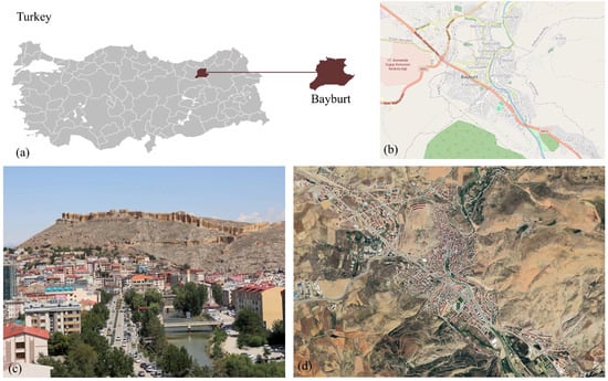
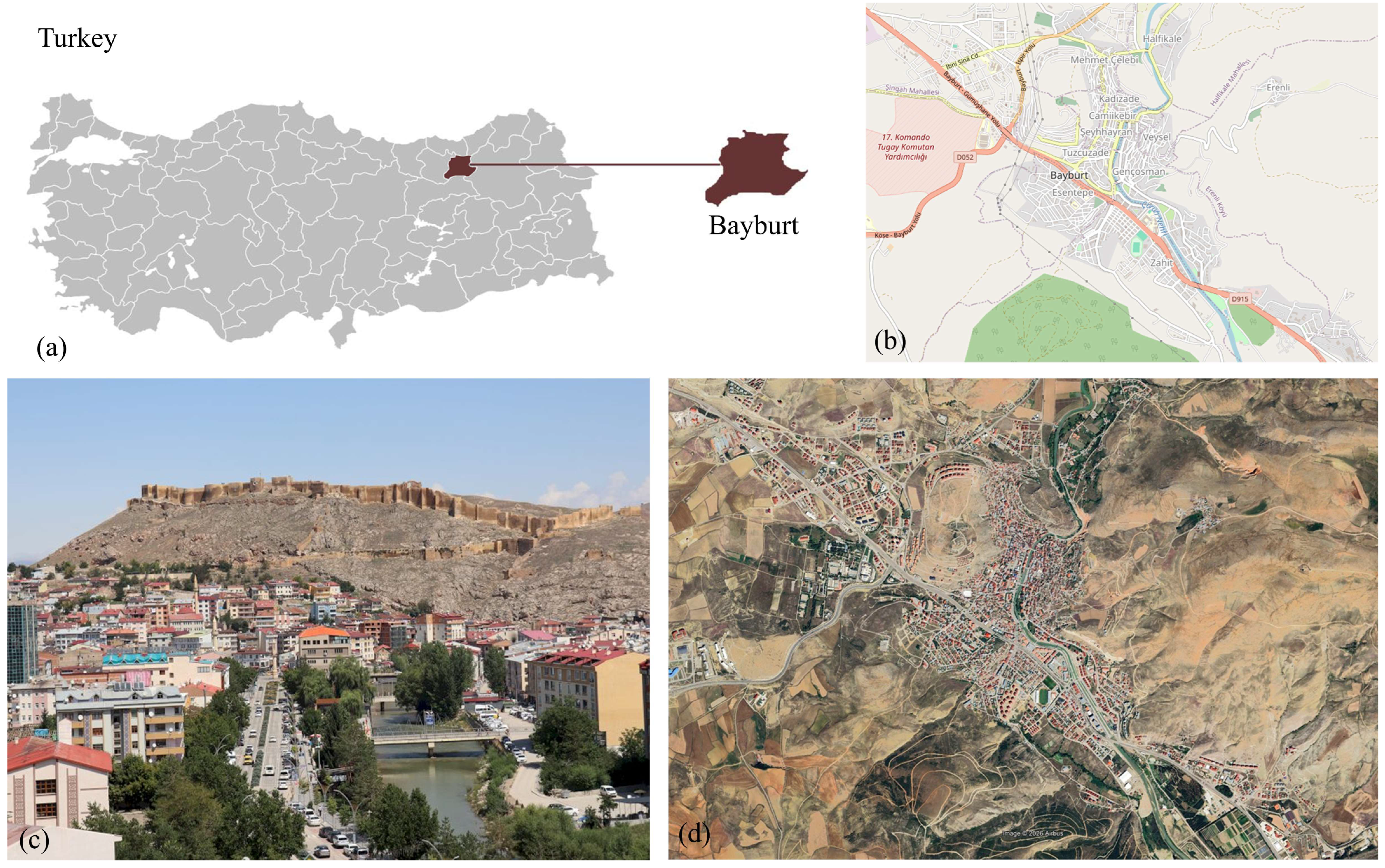
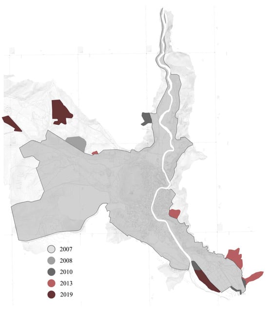
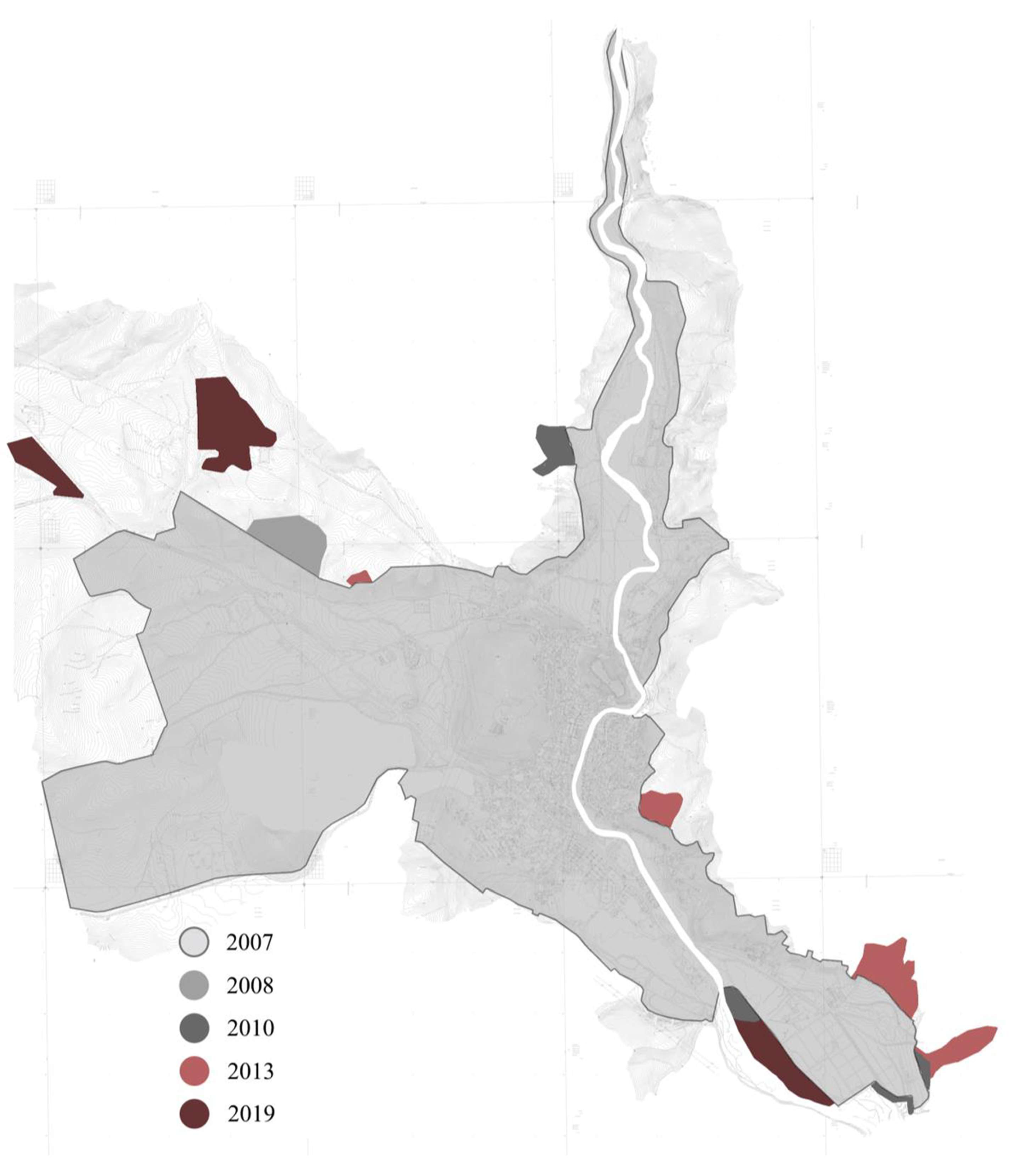
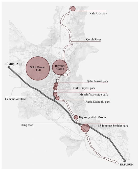
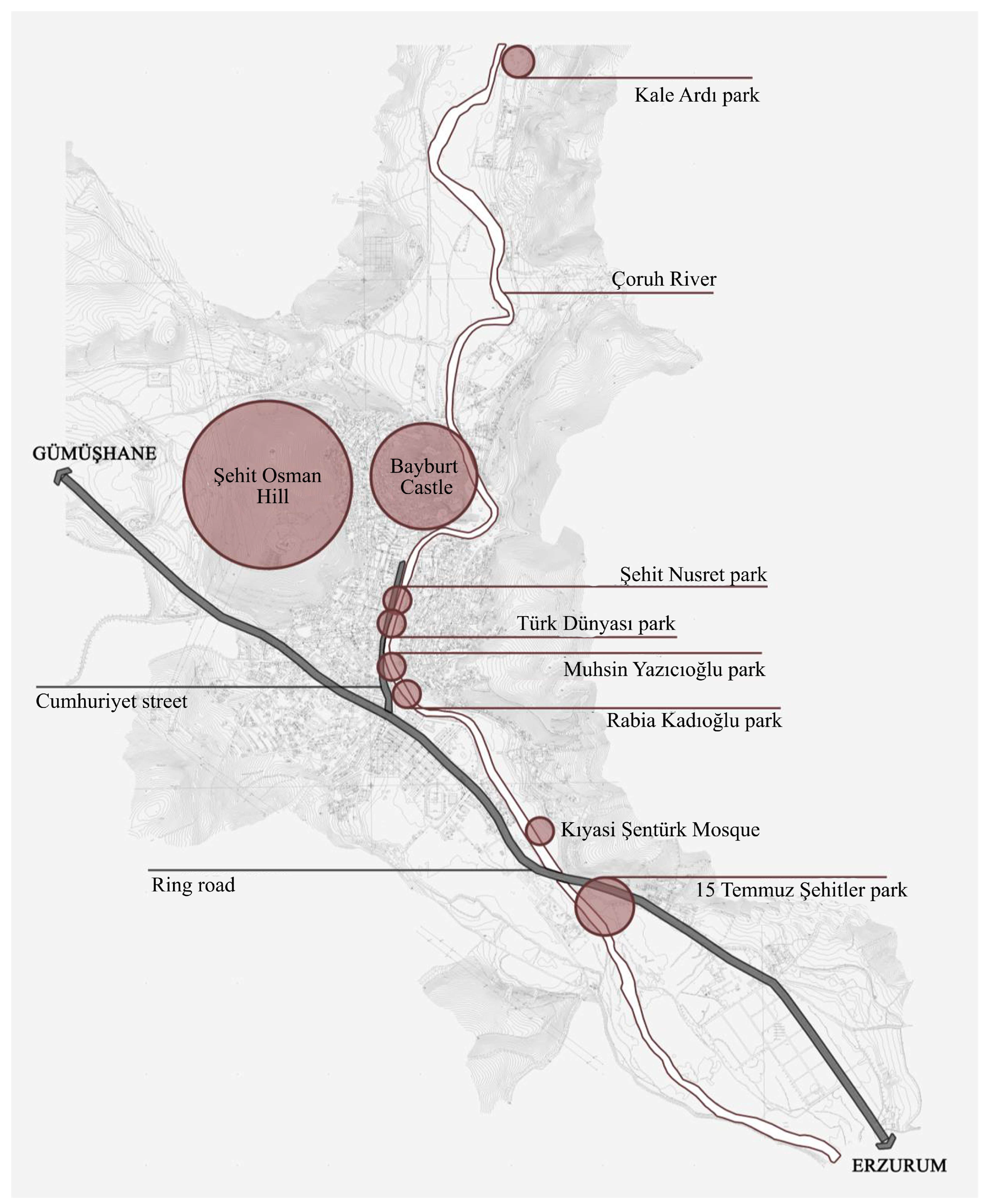
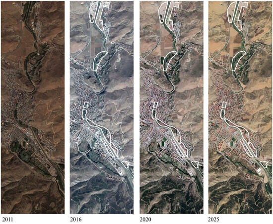
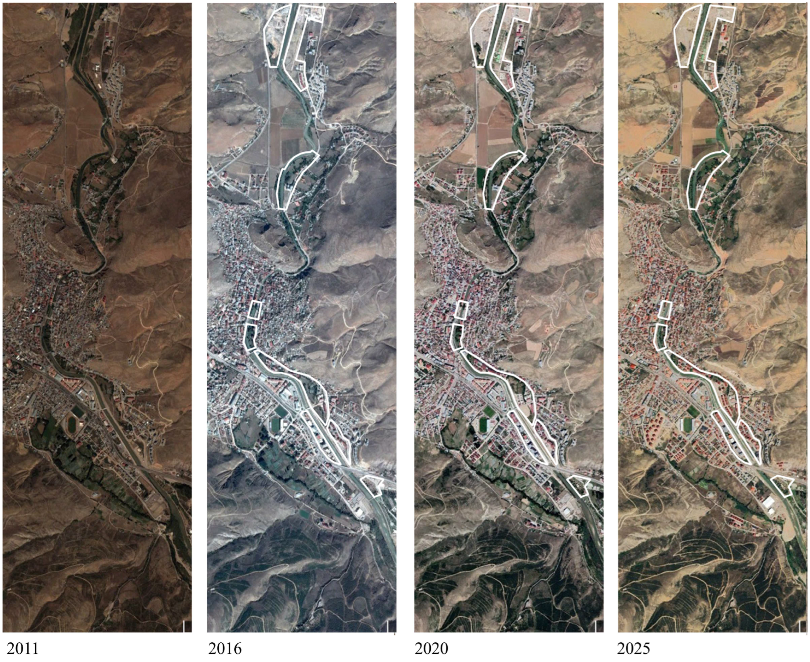
The study area was limited to the approximately 6 km section of the Çoruh River that passes through the entire city center of Bayburt. Open public spaces located on both sides of the river and directly related to the waterfront were included in the scope of the research. The study area and urban context, urban macroform, selected public spaces, and historical spatial change are presented in Figure 1, Figure 2, Figure 3 and Figure 4, respectively.
Figure 1.
Study area and urban context: (a) location of Bayburt province within Türkiye; (b) map of the city of Bayburt; (c) general view of the city of Bayburt, the Çoruh River, and Bayburt Castle; (d) satellite image of the study area. The figure was compiled by the authors. Sources: (a) adapted from the General Directorate of Mapping [39]; (b) adapted from the Bayburt Municipality Urban Information System [40]; (c) adapted from Bayburt.net [41]; (d) prepared using the Google Earth Pro 2025 satellite image [42].
Figure 2.
Urban macroform of Bayburt. Source: Söyler [38].
Figure 3.
Selected public spaces and urban reference points along the Çoruh Riverfront. Source: Söyler [38].
Figure 4.
Historical change along the Çoruh Riverfront according to satellite images from 2011, 2016, 2020, and 2025. The images were compiled by the authors using the historical imagery tool in Google Earth Pro. Source: Google Earth Pro [43].
3.2. Data Collection
The research was conducted in five stages. In the first stage, the literature on public space, riverfronts, urban design quality, publicness, and sustainability was reviewed. In the second stage, riverfront examples from Türkiye and different contexts were comparatively evaluated, and Bayburt was selected as the study area. In the third stage, Bayburt’s urban macroform and waterfront transformation were interpreted through existing maps, visual sources, and satellite images from 2011, 2016, 2020, and 2025 accessed through Google Earth. In the fourth stage, the selected public spaces were observed on site, photographed, and analysis sheets were prepared. In the fifth stage, user evaluations were collected through a questionnaire structured according to PPS dimensions, and place-based quality profiles were produced.
The original fieldwork was conducted between 15 April and 28 April 2022. Thirty users were interviewed in each selected public space unit; thus, data were obtained from a total of 210 participants across seven spaces. Users were randomly selected among people encountered in the area, while attention was paid to achieving a balanced distribution in terms of age, gender, education level, and disadvantaged status. Interviews were distributed across weekdays/weekends and working/nonworking hours. All interviews began with user information, and survey questions were administered after verbal consent was obtained. This data set is not a statistically representative sample of the population of Bayburt. Based on these data, the study is an exploratory, design-oriented, and comparative public space evaluation conducted with an equal number of participants in each space. Updated observation visits and satellite image checks conducted in 2025 were used to contextually verify and update the 2022 field findings.
The questionnaire was designed as a place-based survey instrument derived from the four PPS dimensions. It included user-information questions and evaluation items related to Sociability, Uses and Activities, Access and Linkages, and Comfort and Image. The user-information part recorded basic demographic variables such as gender, age group, education level, frequency of use, and disadvantaged status where voluntarily declared. The evaluation part combined 1–5 scale questions with yes/no items so that both perception-based scores and observable spatial conditions could be converted into comparable dimension values. The complete blank survey form and analysis sheets are provided as Supplementary Materials.
The sampling procedure should be understood as on-site intercept sampling based on random encounters rather than probabilistic sampling from the entire population of Bayburt. Users present in each public space during the fieldwork period were approached, informed about the study, and included after verbal consent. An equal number of participants in each space was preferred to enable comparative place-based interpretation. Therefore, the sample supports exploratory and diagnostic comparison among the seven spaces, but it is not intended to represent the population-level distribution of riverfront users.
The strength of the method is that it addresses user experience and spatial observation together. A purely physical inventory may be insufficient to explain how an area is publicly experienced. Similarly, user satisfaction alone may render physical problems or long-term planning deficiencies invisible. Therefore, through a hybrid approach, user evaluations, on-site observation, visual documentation, and interpretation of satellite imagery were assessed together. The results were interpreted not as individual park scores but in terms of continuity, comfort, and inclusive-use capacity at the scale of the waterfront corridor.
The updated observation and satellite image check conducted in 2025 were not undertaken to resample the 2022 survey data. They were used to contextually examine whether the area’s physical continuity, connections between parks, waterfront barriers, maintenance condition, and general spatial pattern had changed. Therefore, the 2025 check does not add a new-period score to the quantitative values. It is treated as a complementary verification layer that supports the currency and interpretability of the findings.
This temporal structure is a methodological limitation. The 2022 surveys record user perceptions during the original fieldwork period, whereas the 2025 observations provide only a contextual check of the spatial situation. If physical improvements, maintenance changes, or new uses occurred between 2022 and 2025, they may affect the interpretation of the earlier user perceptions. For this reason, the 2025 layer is not used to recalculate PPS scores, and the findings are interpreted as a time-bounded diagnosis supported by later spatial verification rather than as a continuous longitudinal measurement.
3.3. PPS-Based Evaluation Framework and Scoring Protocol
The evaluation framework was adapted from the four main dimensions of PPS. This adaptation was organized to read field observation and user responses together. Table 1 summarizes the evaluation criteria, sub-indicators, and interpretive purpose of each criterion used in the study. This structure strengthened methodological comparability by ensuring that the same questions were applied in each place.
Table 1.
PPS-based evaluation criteria and indicators used in the study.
The survey instrument was developed through content alignment with the PPS place diagram and adapted to the riverfront context through field observation. In this sense, content validity was addressed by matching each item with a PPS dimension and with an observable aspect of waterfront public-space quality, such as continuity, staying, shade, safety, activity diversity, or social encounter. However, the study does not claim a full psychometric validation of the instrument. Reliability testing, including Cronbach’s alpha for the PPS dimensions, could not be completed within the present data structure and is therefore treated as a limitation and a task for future analysis. The scoring and reporting protocol is presented in Table 2.
Table 2.
Scoring and reporting protocol used for the reproducibility of the PPS evaluation.
In addition to the scoring protocol, a three-level reading was used in interpreting the results: (i) the strong and weak dimension profile of each place in itself, (ii) comparative quality differences among places, and (iii) the balance of continuity, comfort, and social programming at the scale of the waterfront corridor. The composite PPS index derived from Table 3 was used as an equally weighted and diagnostic indicator. It was not interpreted as a normative ranking tool or a statistical significance test determining the final value of places.
Table 3.
Comparative quality values of public spaces along the Çoruh Riverfront.
Equal weighting was used in the composite PPS index because the study does not theoretically regard any PPS dimension as superior to the others. The main aim is to diagnose design problems among places comparatively. Therefore, the index does not claim statistical representation or causal explanation. It was evaluated as a diagnostic summary indicator that makes visible the imbalances among Access, Comfort, Uses, and Sociability.
The equal-weighting procedure is therefore a transparent and theory-led choice, not an empirically optimized weighting model. Different weighting schemes could produce different composite values, especially where one dimension contains a larger number of indicators or where a particular dimension is considered more important by users or decision makers. No sensitivity analysis was conducted in this study. Consequently, the composite PPS index should be read together with the four separate dimension scores and the profile-imbalance values, rather than as a stand-alone measure of overall success.
The scope of statistical analysis was limited to descriptive comparison. The purpose of the study is not to generalize at the population level. The aim is to diagnose design problems in places through PPS indicators. Therefore, the results were reported through percentage distributions, dimension averages, the composite index, and profile imbalance. No p-value or claim of causal significance was made in the results. When the raw individual response data become available for final submission, scale internal consistency and differences among places can be tested further with additional statistics.
For this reason, numerical differences between sites are described as relative and diagnostic differences. For example, the gap between July 15 Martyrs Park and the surroundings of Kıyasi Şentürk Mosque indicates a difference in the observed and reported quality profile, but it is not presented as a statistically significant difference. The percentages are used to identify design and management priorities, not to test hypotheses about population-level differences among public spaces.
3.4. Ethics, Data Management, and Limitations
All interviews conducted within the scope of the study were carried out after user information and verbal consent. The data obtained were used only for academic analysis, and no personal identifying information was reported. The research was approved by the relevant board of Erciyes University with the decision dated 17 May 2022, and numbered 2022/24.
The method has five main limitations. First, although the number of users in each place is balanced for comparative reading, it is limited for producing statistical generalizations. Second, the fieldwork was conducted in a single seasonal period. However, riverfront use may vary by season, time of day, and special events. Third, the study is descriptive and design-oriented. Therefore, the findings were supported by percentage values, dimension averages, profile imbalance, and spatial observation rather than p-value-oriented inferential tests. Fourth, the spatial analysis is largely qualitative and observational. It can be strengthened in future studies through network analysis, pedestrian catchment analysis, GPS traces, or Space Syntax studies. Fifth, ecological indicators such as water quality, vegetation structure, permeability, and biodiversity were not measured directly.
In addition to these limitations, three methodological issues should be emphasized. First, the internal consistency of the PPS dimensions has not yet been tested through Cronbach’s alpha or similar reliability measures. Second, the equal-weighted PPS index was not tested through sensitivity analysis. Third, the 2022 survey data and 2025 spatial verification do not constitute a longitudinal data set; they should be interpreted as two complementary but temporally different layers of evidence.
The ecological scope of the research is also limited. Although the study discusses blue-green infrastructure and ecological sensitivity as planning principles, it does not directly measure water quality, riparian vegetation structure, biodiversity, soil permeability, flood risk, or microclimatic performance. Therefore, statements on ecological sustainability and climate adaptation are framed as design-oriented implications derived from spatial observation and literature, not as direct ecological performance results.
4. Results
4.1. Waterfront Continuity and Spatial Fragmentation
Spatial analyses show that although the Çoruh River passes through the urban fabric, the public spaces along the riverfront do not form a continuous, pedestrian-oriented public spine. Although park areas exist along the waterfront, these areas are interrupted by vehicular roads, residential edges, parking uses, barriers, and differences in maintenance and design language. Therefore, the river is experienced not as a legible urban corridor but as a concrete channel and a sequence of disconnected recreational fragments.
This finding constitutes the key interpretive basis for the reported PPS values. Along the Çoruh Riverfront, there is a presence of public space and partial accessibility. However, this presence does not produce an integrated public system that encourages users to move continuously along the waterfront, stay, socialize, and establish a safe/comfortable relationship with the water.
4.2. Comparative Quality Profile of the Selected Public Spaces
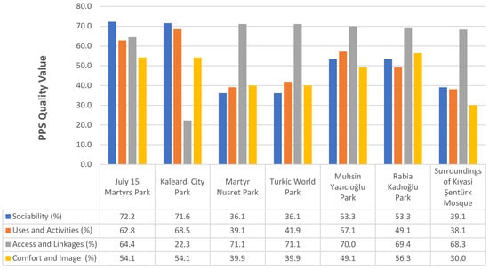
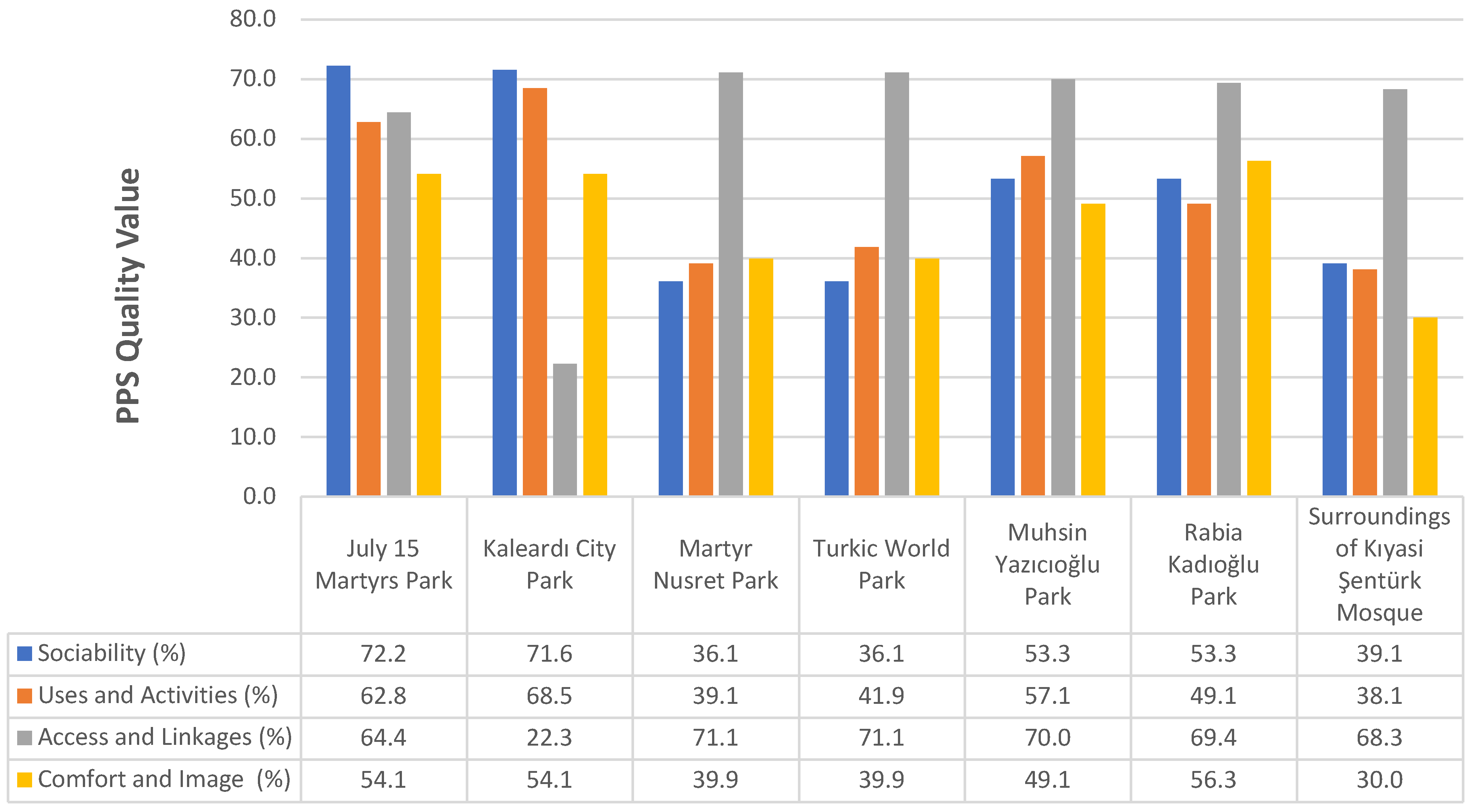
According to the findings, the strongest Sociability values are observed in July 15 Martyrs Park (72.2%) and Kaleardı City Park (71.6%). This result indicates that these areas relatively better support group use, meetings, and social interaction capacity. Rabia Kadıoğlu Park remains at a moderate level in terms of Sociability (53.3%), whereas the surroundings of Kıyasi Şentürk Mosque remain at a low-to-moderate level (39.4%). Thus, social encounter capacity along the waterfront varies substantially from place to place.
In the Access and Linkages dimension, Şehit Nusret Park and Turkic World Park have the highest value (71.1%) in the comparative table. Muhsin Yazıcıoğlu Park (70.0%), Rabia Kadıoğlu Park (69.5%), and the surroundings of Kıyasi Şentürk Mosque (68.8%) also reach medium-high values that indicate potential for movement continuity along the waterfront. By contrast, Kaleardı City Park receives the lowest access value (22.3%) because its everyday pedestrian relationship with the city center is weak.
When Comfort and Image values are examined, all places generally remain at a medium level. The values obtained show that Rabia Kadıoğlu Park is relatively stronger in this dimension (56.4%), while the surroundings of Kıyasi Şentürk Mosque are the weakest area (30.1%). The complete comparative values are presented in Table 3, visualized in Figure 5, and synthesized in Table 4.
Figure 5.
Comparative PPS quality profile of waterfront public spaces, completed with values from the detailed survey tables.
Table 4.
Composite PPS quality index, profile imbalance, and intervention priorities for public spaces along the Çoruh Riverfront.
The derived index showed that the main quality problem along the waterfront is not only “low-scoring parks.” It also revealed a serious imbalance among the criteria. In the Kaleardı case, high Sociability is limited by low Access, while in Şehit Nusret Park, Turkic World Park, and the surroundings of Kıyasi Şentürk Mosque, high Access values do not translate into strong Sociability and Comfort. Therefore, the priority should be less about producing new public spaces and more about equalizing existing spaces in terms of comfort, maintenance, shade, seating, wayfinding, universal access, and inclusive programming standards. This interpretation is based on reading the descriptive index and field observations together.
These values should be interpreted descriptively. The composite index and dimension percentages make it possible to compare the relative profiles of the selected spaces, but they do not demonstrate statistically significant differences among sites. The main analytical value of the index is to show where access, comfort, activity, and sociability are unbalanced and where planning or design intervention should be prioritized.
4.3. Place-Based Findings
Kaleardı City Park has a strong recreational program within itself because of its children’s play areas, picnic areas, walking paths, basic service units, and connections with the water element. Weekend intensity supports Sociability and activity capacity. However, its location away from the city center weakens everyday pedestrian access and its continuity role within the waterfront system.
Şehit Nusret Park is advantageous in terms of accessibility and passage function because of its central location. The cafeteria, seating units, walking paths, and basic amenities support everyday use. However, insufficient seating capacity, low-quality amenities, and a relationship with the waterfront that is mostly passage-oriented limit the area’s potential.
Turkic World Park is also centrally located and includes uses such as seating, a cafeteria, and a street library. Nevertheless, central location alone does not produce quality. Insufficient seating, irregular waste units, accessibility problems at bridge/crossing points, and a weak river-oriented design reduce comfort and inclusiveness.
Muhsin Yazıcıoğlu and Rabia Kadıoğlu parks form a sequential segment with continuity potential along the waterfront. Seating and resting points, lighting, and safety barriers are positive elements. However, lack of shade, arrangements that interrupt pedestrian continuity, and differences in barrier placement weaken universal access and the overall experience.
The values obtained for Rabia Kadıoğlu Park indicate that the area should not be neglected within the waterfront system in terms of Access and Comfort. Because the park is physically located as a continuation of the central waterfront sequence, it should be addressed not as an individual small green space but as a legible waterfront segment together with Muhsin Yazıcıoğlu Park. In this segment, consistent standards for shade, seating, wayfinding, tactile paving, ramps, and waterfront barriers are priorities for public continuity.
The surroundings of Kıyasi Şentürk Mosque show that open areas around religious/public buildings should not be treated as residual landscape voids, but as qualified public nodes that support waterfront publicness. The children’s play area, seating areas, and nearby sports areas are positive. However, lighting, shade, seating comfort, continuity of waste units, and equitable accessibility are weak.
July 15 Martyrs Park has the most intensive program among the examined areas, with picnic areas, commercial units, children’s play areas, outdoor fitness equipment, uses related to the swimming pool, go-kart/ATV activities, and an amphitheater. However, wayfinding, distribution of amenities, edge lighting, irregular parking, material integrity, and waterside safety should be improved.
When the place-based reading is evaluated together, it becomes clear that the main problem along the Çoruh Riverfront is not the absence of individual parks, but the lack of public continuity and the inequality of quality between parks. While activity diversity increases in some places, access, shade, seating comfort, wayfinding, safety, and opportunities for contact with the river do not show the same degree of continuity along the waterfront. Therefore, users experience the waterfront not as a continuous public route but as separate recreational islands with different levels of quality. This fragmented structure also disrupts the city’s overall continuity in a destructive way. The place-based findings and design implications are summarized in Table 5.
Table 5.
Place-based main findings and design implications.
4.4. Integrated Evaluation Across Quality Dimensions
When the four quality dimensions are evaluated together, each place along the riverfront appears to produce a different profile of strengths and weaknesses. This indicates that the quality problem cannot be solved with a single type of intervention. Although accessibility is relatively strong in centrally located public spaces, seating capacity, shade, maintenance, and activity diversity that respond to user intensity may remain limited. In peripheral public spaces, program diversity increases, but the connection with the city center and everyday pedestrian access weakens.
The mean values of the quality dimensions show that the Access and Linkages dimension (62.5%) is stronger than the other dimensions along the Çoruh Riverfront. By contrast, Comfort and Image (46.2%) were identified as the most evident vulnerability of the waterfront system. This finding reveals that the riverfront is not sufficiently integrated in terms of the microclimatic comfort, seating quality, perceived safety, maintenance continuity, wayfinding, and identity production that keep users in place.
From the perspective of the Sociability dimension, the most important problem of the waterfront spaces is the lack of continuity among places of encounter. Users can come together in certain parks, but the social flow between these parks remains weak. A user walking along the waterfront has limited opportunities to walk continuously, encounter different social atmospheres, rest, watch the water, participate in small events, or interact with other user groups. This causes the riverfront to operate not as a public stage but as loosely connected and fragmented islands of use.
The Uses and Activities dimension shows that programs in the waterfront area need to be continuous, diversified, and complementary. The presence of sports and entertainment opportunities in large areas such as July 15 Martyrs Park is an important advantage. However, the fact that these activities are not connected with other parks along the waterfront, and thus present a fragmented pattern of use, limits the effect of the spatial system. Balanced distribution of small- and medium-scale programs along the waterfront can encourage users not only to visit a single park but also to move along the entire waterfront.
The findings in the Access and Linkages dimension reveal that the waterfront’s physical location in the city center is not sufficient for accessibility. Access encompasses a much broader framework. It includes approaching the waterfront from different parts of the city, moving continuously along the waterfront, crossings to the opposite bank, relationships with vehicular roads, and users’ ability to find their way easily. Even if reaching the waterfront is easy, if walking along it is not safe and pleasant, public space quality remains limited and does not offer genuine publicness.
The Comfort and Image dimension is directly related to users’ length of stay in a place. Insufficient lighting, lack of shade, uncomfortable seating units, poorly maintained water elements, and low-quality materials can cause a space to become an area that is merely passed through or used for a short time. By contrast, well-placed shaded seating areas, clean and safe pedestrian paths, arrangements that allow viewing and contact with water, and landscape elements that support local identity encourage users to stay in the place.
These comparative evaluations show that the priority intervention along the Çoruh Riverfront is not only physical renewal, but the establishment of an integrated system together with the urban macroform. To increase public quality along the waterfront, addressing the deficiencies of each park in itself may not be sufficient. In addition, the need to establish thematic, physical, and functional links among parks comes to the fore. These links can integrate the waterfront more strongly into Bayburt’s everyday life. They can transform the perception of the river in the city from a passive natural boundary into an active, legible, and inclusive public space spine. The river passing through the city center has strong potential for a qualified public life.
5. Discussion
5.1. Publicness and Social Sustainability on Small-City Riverfronts
The discussion reads the findings through three main axes: fragmented public continuity along the waterfront, the imbalance between access and the quality of staying in place, and the insufficient support of design decisions by maintenance, programming, and governance processes. When these three axes are evaluated together, it becomes clear that although the Çoruh Riverfront is located within the city, it does not yet function fully as a spine that carries public life.
The findings show that, in small cities, the mere physical passage of a river through the city center is not sufficient to produce publicness. The Çoruh River is a strong natural element in Bayburt’s morphology. Despite this potential, public continuity and everyday accessibility along the waterfront are fragmented and problematic in terms of quality. This situation is another indication that social sustainability is not achieved only through the amount of green space. It has become evident that social sustainability should be evaluated together with access, equity, user diversity, comfort, safety, and opportunities for public encounter.
On the other hand, the differentiation among PPS quality dimensions shows that investments in individual public spaces are not sufficient in waterfront planning. Central parks may be advantageous in terms of access. However, when shade, seating, maintenance, inclusiveness, and activity diversity are inadequate, social sustainability may remain limited. Larger parks with richer programs appear strong in terms of Sociability and Activities. However, when these parks are weakly connected to the city center, they lose their capacity to become part of the waterfront spine.
From this perspective, it becomes necessary to consider the Çoruh Riverfront not as a sum of parks, but as public infrastructure with standards of continuity, accessibility, ecology, and management. Such an approach offers an implication beyond the Bayburt case. In this implication, riverfront transformation in small and medium-sized cities is not merely a landscape design or recreational investment; it is an urban design and management issue that jointly produces social and environmental sustainability.
The findings also support the interpretation of the Çoruh Riverfront as a fluid territory. The observed fragmentation among parks, the uneven relationship between access and staying quality, and the weak integration between the river, the urban fabric, and management practices show that waterfront publicness is produced through changing territorial relations rather than through isolated landscape elements. Therefore, the Bayburt case should be read not only as a set of recreational public spaces, but as an adaptive socio-ecological interface whose public value depends on continuous spatial, institutional, and environmental coordination [27].
This result emphasizes that blue-green infrastructure should not be treated only as flood control or landscape improvement. Recent studies also emphasize that blue-green infrastructure should be designed as a multifunctional urban system that produces health, social equity, and quality of public life [24,25,26,44,45]. The spine approach proposed for the Çoruh Riverfront should be evaluated within this scope. A sustainable framework and argument can be developed to the extent that the goal of accessible green public space is combined with social programming, a maintenance protocol, ecological buffers, and water-sensitive design principles.
At the same time, this study does not empirically measure the ecological performance of the Çoruh Riverfront. The discussion of ecological continuity, resilience, and climate adaptation is therefore limited to spatial and planning implications. Direct ecological assessment would require additional indicators such as water quality, riparian habitat condition, permeability, biodiversity, flood sensitivity, and thermal comfort measurements.
The findings clearly show the difference between the presence of public space and the quality of public space. The existence of many parks or open areas along the Bayburt Çoruh Riverfront does not mean that the waterfront is integrated with public life. Accordingly, public integration is understood to be related to the willingness to stay in place, encounters among different users, perceived safety, comfort, diversity of activities, and continuity.
This result points to a fundamental problem that applies to many riverfronts in Türkiye. Riverfronts in Türkiye are often addressed through flood control, road crossings, housing development, or fragmented recreational arrangements. However, sustainable waterfront planning and design should bring together public access, ecological sensitivity, and social use without ignoring flood risk.
Strengthening the Sociability dimension should not mean filling the Çoruh Riverfront with more amenities. Children’s play areas, sports and meeting points for young people, shaded seating areas for older adults, continuous and safe routes for users with disabilities, terraces that allow viewing and contact with water, small-scale cultural event areas, and pedestrian nodes that support everyday encounters should be designed in an integrated manner.
One of the important problems is that water-related distinctive programs remain limited in terms of Uses and Activities. Viewing terraces, nature education routes, temporary open-air exhibitions, local producer stands, cultural heritage routes, and low-impact recreational activities can make the waterfront area more distinctive. However, these programs should not overlook flood safety and ecological sensitivity.
Another important issue is the management dimension. The quality of public waterfront spaces is not limited to initial construction quality. Maintenance, safety, programming, participatory feedback, data monitoring, and inter-institutional coordination processes are also decisive. For the Çoruh Riverfront, a shared and integrated waterfront management framework can be proposed among the municipality, relevant public institutions, local user groups, professional chambers, universities, and civic actors.
5.2. Planning and Design Principles
The “Power of 10+” and “lighter, quicker, cheaper” approaches emphasized in the PPS literature suggest a waterfront management model for the Çoruh Riverfront that is strengthened through small interventions, monitored with user feedback, and updated over time. Therefore, wayfinding, shade, seating, lighting, ramps, waste units, safe waterside arrangements, and small-scale event programs should be considered low-cost but high-impact first areas of intervention.
The planning and design principles emphasized below are directly related to the weak quality dimensions identified in the Section 4.2. Low access values were matched with the principles of pedestrian-bicycle continuity and public-transport integration. Low Comfort and Image values were matched with standards for shade, seating, maintenance, lighting, and wayfinding. Low Sociability and Use values were matched with inclusive programming, local identity, and participatory management principles.
The first principle is to plan the Çoruh Riverfront as a continuous pedestrian and bicycle spine. This spine should define park entrances, bridges, urban nodes, public-transport stops, ecological buffers, flood-sensitive areas, and maintenance responsibilities together.
In terms of implementation, this spine can be addressed in three phases. In the short term, deficiencies in wayfinding, lighting, seating, shade, and accessibility can be addressed. In the medium term, bridges, park entrances, and public-transport stops should be connected through a continuous pedestrian-bicycle route. In the long term, ecological continuity should be strengthened through riparian buffers, permeable surfaces, and water-sensitive landscape components.
The second principle is to accept universal design not as an additional improvement but as an indispensable basic standard. Continuous tactile paving, barrier-free crossings, accessible ramps, safe bridge connections, legible wayfinding, and regular resting points should be provided along the waterfront.
The third principle is to establish a maintenance standard and integrated design for Comfort and Image. Seating units, shade, lighting, waste units, surface materials, edge protections, and wayfinding elements should be distributed consistently from one park to another, without abrupt changes.
The fourth principle is to avoid excessive commercialization of the waterfront and to diversify the activity program. Small-scale cultural events, local markets, educational river/ecology walks, children’s activities, and quiet resting areas can be supported while preserving public accessibility.
The fifth principle is to address ecological design together with public use. This includes local planting, permeable surfaces, riparian buffers, stormwater-sensitive design, and the creation of seasonal flood awareness. This structure should be considered together with walking, seating, and social interaction areas.
The sixth principle is to sustain monitoring and participatory management after design and implementation. User counts, satisfaction surveys, maintenance audits, accessibility checks, and ecological indicators are important data. These data can help monitor whether the waterfront becomes more inclusive and sustainable over time and support necessary interventions.
The seventh principle is to relate public space to local identity. The waterfront area has strong cultural landscape potential. When the Çoruh River, Bayburt Castle, the Clock Tower, and historical trade routes are considered together, this potential provides a strong basis. From this perspective, urban identity should be made visible along the waterfront route through local historical narratives, wayfinding panels, cultural heritage connections, the use of local materials, and public art practices.
The eighth principle is to design ecological continuity as an area for learning and awareness. Planning principles such as using local and resilient species, increasing permeable surfaces, and supporting habitat continuity can support this perspective. At the same time, information panels on flood and water-cycle themes, nature observation points, and outdoor learning stops for school groups can be considered within this scope.
The ninth principle is to sustain participatory processes throughout the entire life cycle. Neighborhood residents, children, young people, older adults, people with disabilities, shopkeepers, local government, academic institutions, and civil society representatives should be included in the process. This participation approach should not occur only at the beginning or end of the process; rather, a participatory understanding should prevail throughout the entire process. Tools such as walking audits, user mapping studies, temporary intervention trials, and post-implementation satisfaction measurements can contribute to this process.
The tenth principle is to balance the economic use of the waterfront with public benefit without surrendering it to commercial dominance. Cafeterias, small-scale commercial units, and event uses can create vitality as long as they remain balanced. However, they should not cause privatization of the waterfront, closure of passages, or the formation of a user profile focused only on consumption. The basic character of the public waterfront spine should be free, open, inclusive, and belong to everyone.
5.3. Limitations and Future Research
This research is exploratory and design-oriented. The equal subsample of 30 users in each open public space allows comparative interpretation among places, but does not provide statistical generalization. Therefore, the research results should be read not as judgments about “which place is more valuable,” but as diagnostic findings indicating which quality dimension should be strengthened in which place. In future studies, the sample should be enlarged, users should be stratified according to demographic profiles, and seasonal use patterns should be compared.
Spatial analysis can be strengthened through GIS-based access modeling, network analysis, land-cover change calculation, pedestrian catchment mapping, and visibility analysis. The ecological dimension can be developed through vegetation structure, permeability, thermal comfort, and water-related risk indicators. Such measurements can support the public quality problems descriptively identified in this study with stronger quantitative evidence.
Within this framework, measurable indicators are proposed for future research. These can be defined as the 400–800 m pedestrian catchment area, density of shaded seating units, continuity of accessible ramps, nighttime lighting level, proportion of permeable surface, continuity of riparian planting, user counts, seasonal satisfaction scores, and frequency of maintenance intervention. These indicators can transform the exploratory findings of the study into a waterfront performance system that can be monitored throughout the entire life cycle [24,25,26,44,45,46,47,48,49].
In the future, Bayburt can be compared with other Turkish cities such as Amasya, Eskişehir, Edirne, Bartın, Hatay, or Artvin to develop transferable design principles for small- and medium-sized urban waterfronts.
Raw item-level user responses can be organized into a regular data set. Thus, internal consistency analyses can be conducted for the PPS dimensions. Such an additional analysis would strengthen the reliability and comparability of the method without changing the study’s exploratory design approach.
Future studies should also test alternative weighting scenarios for the PPS index and compare PPS results with other publicness-assessment methods. Combining PPS with the Star Model of Publicness, Space Syntax analysis, behavioral mapping, and GIS-based accessibility modeling would make it possible to compare perceived public-space quality with ownership/control conditions, network integration, observed use patterns, and spatial accessibility.
6. Conclusions
This study evaluated the Bayburt Çoruh Riverfront within the framework of public space quality and sustainability. The findings showed that multiple active public spaces exist along the waterfront. However, these spaces do not yet function as a continuous, inclusive, and ecologically sensitive public corridor. In areas such as July 15 Martyrs Park and Kaleardı City Park, Sociability and Uses/Activities values are relatively strong. However, access, comfort, image, and program continuity are not balanced along the entire waterfront.
The conclusions should be read within the measured scope of the study. The evidence directly supports claims about perceived public-space quality, access, comfort, activity diversity, sociability, continuity, and observed spatial fragmentation. Broader statements on social sustainability, governance, ecological resilience, and climate adaptation are presented as planning implications that follow from these findings, not as direct measurements of those wider processes.
The main conclusion is that riverfront publicness does not emerge automatically through the presence of water or green space. This publicness is produced through integrated design, maintenance, and management. For Bayburt, this means transforming the Çoruh Riverfront from disconnected recreational fragments into an inclusive, pedestrian-oriented, blue-green public spine that supports social interaction. Such a transformation would strengthen everyday social encounters, urban identity, ecological awareness, and social sustainability.
In line with these results, the main recommendation is a transition toward an integrated public waterfront spine. Accordingly, it has been revealed that a waterfront consisting of a sequence of fragmented parks does not offer high-quality public use. The integrated spine should be related to historical and cultural focal points, neighborhood entrances, squares, parks, and the pedestrian transportation system. It should be supported by pedestrian-bicycle continuity, universal access, comfortable seating and shaded areas, safe lighting, water-viewing terraces, nature-based learning areas, local culture routes, and flood-sensitive ecological landscape decisions.
The PPS profile obtained shows that the most urgent area of intervention for Bayburt is not access itself, but the “quality of staying in accessible areas.” Therefore, shade, seating, wayfinding, lighting, maintenance, universal access, and opportunities for safe contact with water are initially low-cost. However, these approaches should be treated as high-impact strategic interventions. These interventions will enable high access values to turn into Sociability and Comfort.
In the context of sustainability, it is emphasized that small-city riverfronts should be treated as strategic public infrastructures. Ecological continuity, access equity, public space quality, cultural identity, and long-term governance must be designed together. These areas are not merely recreational spaces; they can become social-ecological spines that support sustainable urban life.
In this sense, the revised study positions the Çoruh Riverfront as a fluid territorial interface. This perspective clarifies that the proposed public waterfront spine should not be understood as a fixed linear design object, but as a flexible socio-ecological structure shaped by publicness, spatial continuity, governance, ecological sensitivity, and the changing interaction between Bayburt’s urban development and the Çoruh River [27].
As a result, the priority strategy for the Bayburt Çoruh Riverfront is to establish an integrated waterfront spine that connects existing public spaces through continuous universal access, shaded and comfortable staying areas, legible wayfinding, regular maintenance, local identity narratives, and water-sensitive landscape decisions. This strategy offers a framework for reconsidering riverfronts in small cities in terms of sustainability, quality of public life, and blue–green infrastructure performance.
Supplementary Materials
The following supporting information can be downloaded at: https://www.mdpi.com/article/10.3390/su18136504/s1, Figure S1: Analyses of Kaleardı City Park. Source: Söyler [38]; Figure S2: Analyses of Şehit Nusret Park—source: Söyler [38]; Figure S3: Analyses of the Turkic World Park—source: Söyler [38]; Figure S4: Analyses of Muhsin Yazıcıoğlu Park. Source: Söyler [38]; Figure S5: Analyses of Rabia Kadıoğlu Park—source: Söyler [38]; Figure S6: Analyses of the surroundings of Kıyasi Şentürk Mosque—source: Söyler [38]; Figure S7: Analyses of July 15 Martyrs Park—source: Söyler [38]; Table S1: Analysis and survey data for Kaleardı City Park. Source: Söyler [38]; Table S2: Analysis and survey data for Şehit Nusret Park. Source: Söyler [38]; Table S3: Analysis and survey data for Turkic World Park. Source: Söyler [38]; Table S4: Analysis and survey data for Muhsin Yazıcıoğlu Park and Rabia Kadıoğlu Park. Source: Söyler [38]; Table S5: Analysis and survey data for Rabia Kadıoğlu Park. Source: Söyler [38]; Table S6: Analysis and survey data for the surroundings of Kıyasi Şentürk Mosque. Source: Söyler [38]; Table S7: Analysis and survey data for July 15 Martyrs Park. Source: Söyler [38]; Table S8: Blank survey form. Source: Söyler [38].
Author Contributions
Conceptualization, B.G.S. and U.D.; methodology, B.G.S. and U.D.; field research, B.G.S.; data curation and analysis, B.G.S. and U.D.; writing—original draft preparation, B.G.S.; review and editing, U.D.; visualization, B.G.S.; supervision and academic oversight, U.D. All authors have read and agreed to the published version of the manuscript.
Funding
This research received no external funding.
Institutional Review Board Statement
The study was approved by the relevant board of Erciyes University with the decision dated 17 May 2022, and numbered 2022/24. The study was conducted in accordance with the principles of information and voluntary participation regarding survey data collected from human participants.
Informed Consent Statement
Verbal consent was obtained from all users before the survey.
Data Availability Statement
The summary survey tables and analysis sheets used in this study are provided in the Supplementary Materials. Additional anonymized data and calculation tables may be requested from the corresponding author upon reasonable request.
Acknowledgments
This article is based on a revised and expanded part of the first author’s master’s thesis, prepared at Erciyes University under the supervision of the second author [38]. During the preparation of the manuscript, ChatGPT Plus using the GPT-5.5 Thinking model (OpenAI; accessed on 2026) and Grammarly for Windows (version 1.2.270.1904; Grammarly, Inc.) were used only as auxiliary tools for technical editing, expression improvement, and English terminology checking. The final content was checked by the authors, and all scientific responsibility belongs to the authors.
Conflicts of Interest
The authors declare no conflicts of interest.
Abbreviations
The following abbreviations are used in this manuscript:
| PPS | Project for Public Spaces |
| SDG | Sustainable Development Goals |
| Blue-green infrastructure | An urban infrastructure approach that addresses water, green spaces, and ecological connections together |
References
- Carmona, M.; Heath, T.; Oc, T.; Tiesdell, S. Public Places Urban Spaces: The Dimensions of Urban Design; Architectural Press: Oxford, UK, 2003. [Google Scholar]
- Carmona, M.; de Magalhães, C.; Hammond, L. Public Space: The Management Dimension; Routledge: London, UK, 2008. [Google Scholar]
- Madanipour, A. Public and Private Spaces of the City; Routledge: London, UK, 2003. [Google Scholar]
- Jacobs, A.B. Great Streets; MIT Press: Cambridge, MA, USA, 1993. [Google Scholar]
- Gehl, J. Life Between Buildings: Using Public Space; Van Nostrand Reinhold: New York, NY, USA, 1987. [Google Scholar]
- Carr, S.; Francis, M.; Rivlin, L.G.; Stone, A.M. Public Space; Cambridge University Press: Cambridge, UK, 1992. [Google Scholar]
- Uzgören, G.; Erdönmez, M.E. Kamusal Açık Alanlarda Mekan Kalitesi ve Kentsel Mekan Aktiviteleri İlişkisi Üzerine Karşılaştırmalı Bir İnceleme [A Comparative Study on the Relationship between Space Quality and Urban Activities in Public Open Spaces]. MEGARON 2017, 12, 41–56. (In Turkish) [Google Scholar] [CrossRef] [Scilit]
- Kılıç, A. Kıyıdan Geri Çekilme Sürecinde Kent-Kıyı İlişkisi, Kentsel Kıyı Tanımı ve Bu Kavrama Dayalı Kentsel Kıyı Gelişme Stratejileri: İstanbul Örneği [The City-Coast Relationship in the Process of Retreating from the Coast, the Definition of Urban Coast and Urban Coastal Development Strategies Based on This Concept: The Case of Istanbul]. Ph.D. Thesis, Yıldız Technical University, Istanbul, Türkiye, 1999. (In Turkish) [Google Scholar]
- Gedikli, B. Kıyıyı Yaşamak, Kıyıyı Planlamak [Living the Coast, Planning the Coast]. In Proceedings of the 7th Coastal Engineering Symposium, Trabzon, Türkiye, 21–23 November 2011; TMMOB Chamber of Civil Engineers: Ankara, Türkiye, 2011; pp. 23–33. (In Turkish) [Google Scholar]
- Uçlar, S. Bütünleşik Kıyı Alanları Yönetimi ve İstanbul Örneği [Integrated Coastal Zone Management and the Case of Istanbul]. Ph.D. Thesis, Istanbul Technical University, Istanbul, Türkiye, 2012. (In Turkish) [Google Scholar]
- Yıldız, R.; Şenlier, N.; İmren Güzel, B. Sustainable Urban Design Guidelines for Waterfront Developments. In Proceedings of the 2nd International Sustainable Buildings Symposium, Ankara, Türkiye, 28–30 May 2015; pp. 487–494. [Google Scholar]
- Sokolova, M.V.; Fath, B.D.; Grande, U.; Buonocore, E.; Franzese, P.P. The Role of Green Infrastructure in Providing Urban Ecosystem Services: Insights from a Bibliometric Perspective. Land 2024, 13, 1664. [Google Scholar] [CrossRef] [Scilit]
- Zhu, L.; Gao, C.; Wu, M.; Zhu, R. Integrating Blue-Green Infrastructure with Gray Infrastructure for Climate-Resilient Surface Water Flood Management in the Plain River Networks. Land 2025, 14, 634. [Google Scholar] [CrossRef] [Scilit]
- Wang, M.; Su, Y.; Wang, J. How to Improve Blue-Green-Gray Infrastructure to Optimize River Cooling Island Effect on Riparian Zone for Outdoor Activities in Summer. Land 2025, 14, 1330. [Google Scholar] [CrossRef] [Scilit]
- Sağlık, A.; Kelkit, A.; Sağlık, E. Kentsel Kıyı Alanlarında Yerleşim Baskısı Sonucu Oluşan Çevresel Sorunlar: Çanakkale Kenti Örneği [Environmental Problems Caused by Settlement Pressure in Urban Coastal Areas: The Case of Çanakkale]. Biyol. Bilim. Araştırma Derg. 2012, 5, 145–149. (In Turkish) [Google Scholar]
- Polat, S.; Vural Arslan, T. Kamusal Kıyı Alanlarını Katılımcı Tasarımla Geliştirebilmek Mümkün mü? Bursa Mudanya’da Yıldıztepe Sosyal Yaşam Merkezi Projesi [Is It Possible to Develop Public Waterfront Areas through Participatory Design?] The Yıldıztepe Social Life Center Project in Mudanya, Bursa. Kent. Akad. 2019, 12, 531–545. (In Turkish) [Google Scholar] [CrossRef] [Scilit]
- Abay, E.; Erdönmez, E. Kent ile Kıyı Arasında Kamusal Mekan Kalitesinin Frankfurt-Main Örneği Üzerinden İncelenmesi [Examining Public Space Quality between the City and the Coast through the Frankfurt-Main Example]. Kent. Akad. 2021, 14, 1117–1136. (In Turkish) [Google Scholar] [CrossRef] [Scilit]
- Akkar Ercan, M. Endüstri Sonrası Kentlerin Değişen ve Dönüşen Kamusal Mekânları [Changing and Transforming Public Spaces of Post-Industrial Cities]. Planlama 2016, 26, 193–203. (In Turkish) [Google Scholar] [CrossRef] [Scilit]
- Kimic, K.; Ostrysz, K. Assessment of Blue and Green Infrastructure Solutions in Shaping Urban Public Spaces-Spatial and Functional, Environmental, and Social Aspects. Sustainability 2021, 13, 11041. [Google Scholar] [CrossRef] [Scilit]
- Whyte, W.H. The Social Life of Small Urban Spaces; Project for Public Spaces: New York, NY, USA, 1980. [Google Scholar]
- Malkoç True, E.; Sönmez Türel, H. PPS (Project for Public Spaces)’nin Mekan Diyagramı Temelinde Kamusal Bir Mekanın Analizi [Analysis of a Public Space Based on the Place Diagram of PPS (Project for Public Spaces)]. J. Agric. Fac. Ege Univ. 2017, 54, 319–326. (In Turkish) [Google Scholar] [CrossRef] [Scilit]
- Jagadisan, S. Promoting Integrated Blue-Green Infrastructure for Urban Resilience: Lessons Learned from Case Studies. Front. Water 2024, 6, 1474411. [Google Scholar] [CrossRef] [Scilit]
- United Nations Human Settlements Program (UN-Habitat). 11.7 Public Space. Available online: https://unhabitat.org/11-7-public-space (accessed on 24 May 2026).
- Yaralioglu, I.; Kara, C. Sustainable Urban Design Approach for Public Spaces Using an Analytical Hierarchy Process (AHP). Land 2025, 14, 19. [Google Scholar] [CrossRef] [Scilit]
- Zeng, H.-M.; Sieh, L.; Zhang, D.; Huang, H.; Zhang, Y.-Z.; Tsou, J.-Y. Exploring the Impact of the Publicness of Public Space in Hong Kong: A Structural Equation Modeling Approach. Land 2025, 14, 91. [Google Scholar] [CrossRef] [Scilit]
- Gomes, M.V.R.; Veról, A.P. Assessing Public Perceptions of Blue-Green Infrastructure in Urban Watersheds: A Case Study of Acari River, Brazil. Sustainability 2024, 16, 10276. [Google Scholar] [CrossRef] [Scilit]
- Costa, J.P.; Andrade, M.J.; Dal Cin, F. The (Re)Industrialised Waterfront as a “Fluid Territory”: The Case of Lisbon and the Tagus Estuary. Urban Plan. 2023, 8, 363–377. [Google Scholar] [CrossRef] [Scilit]
- World Health Organization Regional Office for Europe. Assessing the Value of Urban Green and Blue Spaces for Health and Well-Being; WHO Regional Office for Europe: Copenhagen, Denmark, 2023; p. WHO/EURO:2023-7508-47275-69347. [Google Scholar]
- Hunter, R.F.; Nieuwenhuijsen, M.; Fabian, C.; Murphy, N.; O’Hara, K.; Rappe, E.; Sallis, J.F.; Lambert, E.V.; Sarmiento, O.L.; Sugiyama, T.; et al. Advancing Urban Green and Blue Space Contributions to Public Health. Lancet Public Health 2023, 8, e735–e742. [Google Scholar] [CrossRef] [Scilit] [PubMed]
- European Environment Agency. Who Benefits from Nature in Cities? Social Inequalities in Access to Urban Green and Blue Spaces across Europe. EEA Briefing. 2022. Available online: https://www.eea.europa.eu/en/analysis/publications/who-benefits-from-nature-in-cities-social-inequalities-in-access-to-urban-green-and-blue-spaces-across-europe (accessed on 24 May 2026).
- Varna, G.; Tiesdell, S. Assessing the Publicness of Public Space: The Star Model of Publicness. J. Urban Des. 2010, 15, 575–598. [Google Scholar] [CrossRef] [Scilit]
- Hillier, B.; Hanson, J. The Social Logic of Space; Cambridge University Press: Cambridge, UK, 1984. [Google Scholar]
- Project for Public Spaces. What Is Placemaking? Available online: https://www.pps.org/article/what-is-placemaking (accessed on 30 May 2026).
- Project for Public Spaces. What Makes a Successful Place? Available online: https://www.pps.org/article/grplacefeat (accessed on 30 May 2026).
- Project for Public Spaces. The Power of 10+. Available online: https://www.pps.org/article/the-power-of-10 (accessed on 30 May 2026).
- Project for Public Spaces. Eleven Principles for Creating Great Community Places. Available online: https://www.pps.org/article/11steps (accessed on 30 May 2026).
- Project for Public Spaces. How to Turn a Place Around; Project for Public Spaces: New York, NY, USA, 2000. Available online: https://www.pps.org/product/how-to-turn-a-place-around-2 (accessed on 30 May 2026).
- Gürbüz Söyler, B. Kentsel Kıyı Alanları ve Kamusal Mekân İlişkisi: Bayburt Kent Örneği [Urban Waterfront Areas and the Public Space Relationship: The Case of Bayburt]. Master’s Thesis, Erciyes University, Kayseri, Türkiye, 2022. (In Turkish) [Google Scholar]
- General Directorate of Mapping. Physical Provincial Map of Bayburt. Available online: https://www.harita.gov.tr/urun/bayburt-fiziki-il-haritasi/442 (accessed on 28 May 2026).
- Bayburt Municipality. Bayburt Municipality Urban Information System. Available online: https://bulutkbs.gov.tr/Rehber/#/app (accessed on 28 May 2026).
- Bayburt.net. Population of Bayburt. Available online: https://www.bayburt.net/bayburt-n%C3%BCfusu-2 (accessed on 28 May 2026).
- Google Earth Pro. Satellite Image of Bayburt, Türkiye. Google Earth Pro, 2025 Imagery. Available online: https://earth.google.com/ (accessed on 28 May 2026).
- Google LLC. Google Earth Pro, Version 7.3.6, Google LLC: Mountain View, CA, USA, 2022.
- Huang, Y.; Ye, L.; Chen, Y. Sustainable Urban Landscape Quality: A User-Perception Framework for Public Space Assessment and Development. Sustainability 2025, 17, 3992. [Google Scholar] [CrossRef] [Scilit]
- Forczek-Brataniec, U.; Jamioł, K. The Role of Public Space in Building the Resilience of Cities: Analysis of Representative Projects from IFLA Europe Exhibitions. Sustainability 2024, 16, 5105. [Google Scholar] [CrossRef] [Scilit]
- Meerow, S.; Newell, J.P. Spatial Planning for Multifunctional Green Infrastructure: Growing Resilience in Detroit. Landsc. Urban Plan. 2017, 159, 62–75. [Google Scholar] [CrossRef] [Scilit]
- Dimitrov, S.; Borisova, B.; Ivanova, A.; Iliev, M.; Semerdzhieva, L.; Ruseva, M.; Stoyanova, Z. Digital Geospatial Twinning for Revaluation of a Waterfront Urban Park Design (Case Study: Burgas City, Bulgaria). Land 2025, 14, 1642. [Google Scholar] [CrossRef] [Scilit]
- Czałczyńska-Podolska, M.; Bal, W.; Sęk, M. The Role of Rivers in Building the Image of a Sustainable City: Evidence from Szczecin (Poland). Sustainability 2025, 17, 9655. [Google Scholar] [CrossRef] [Scilit]
- Luo, Z.; Marchi, L.; Gaspari, J. A Systematic Review of Factors Affecting User Behavior in Public Open Spaces under a Changing Climate. Sustainability 2025, 17, 2724. [Google Scholar] [CrossRef] [Scilit]

Disclaimer/Publisher’s Note: The statements, opinions and data contained in all publications are solely those of the individual author(s) and contributor(s) and not of MDPI and/or the editor(s). MDPI and/or the editor(s) disclaim responsibility for any injury to people or property resulting from any ideas, methods, instructions or products referred to in the content. |
© 2026 by the authors. Licensee MDPI, Basel, Switzerland. This article is an open access article distributed under the terms and conditions of the Creative Commons Attribution (CC BY) license.