


Abstract
Traditional Chinese villages are important carriers of rural heritage, collective memory, vernacular landscapes, and living cultural traditions. However, rapid urbanization, agricultural modernization, climate change, and tourism development have increasingly threatened their spatial integrity and cultural continuity, highlighting the need for evidence-based conservation and adaptive management. This study examines the spatial distribution patterns and associated factors of 8155 national-level traditional villages in China. An integrated spatial analytical framework was developed by combining kernel density estimation, spatial autocorrelation analysis, Geodetector, and multiscale geographically weighted regression (MGWR). The results show that: (1) traditional villages are unevenly distributed across China and form a distinct “three-core and multi-node” spatial pattern, with major high-density clusters concentrated in several cross-provincial regions and secondary clusters distributed in other heritage-rich areas; (2) the spatial differentiation of traditional village density is statistically associated with natural, cultural, and socioeconomic factors, among which temperature and precipitation show the strongest explanatory power, while cultural endowment, ecological quality, and socioeconomic variables show more context-dependent associations; and (3) compared with OLS and conventional GWR, MGWR improves model performance by capturing spatially heterogeneous and scale-dependent relationships through variable-specific bandwidths. These findings provide national-scale empirical evidence for differentiated conservation planning and support the integration of traditional village protection with rural revitalization, cultural heritage conservation, and sustainable regional development.
1. Introduction
Traditional villages are tangible and living repositories of agricultural civilization, embodying long-term human adaptation to local environments. As important forms of living heritage, they integrate vernacular architecture, intangible cultural practices, ecological landscapes, traditional production modes, and collective memory [1,2]. Globally, these settlements are valuable for preserving cultural diversity, promoting rural sustainability, and understanding long-term human–environment interactions [3,4]. They should therefore be understood not merely as architectural remains, but as living cultural landscapes in which ecological knowledge, agricultural practices, social relations, and local identities are embedded in place.
Traditional villages worldwide exhibit distinct spatial patterns shaped by natural conditions and historical–cultural processes. In Europe, traditional rural landscapes have been examined in relation to historical continuity, low-intensity land use, landscape services, agricultural intensification, land abandonment, and rural restructuring [5,6]. In Mediterranean regions, montado and dehesa agroforestry landscapes illustrate how traditional agro-silvopastoral systems sustain ecological functions and cultural values under semiarid conditions [7,8]. In East and Southeast Asia, Japanese satoyama landscapes and Balinese subak irrigation systems demonstrate the close coupling of village communities, agricultural production, forest management, and water governance [9,10]. These cases indicate that traditional villages are a globally relevant research object situated at the intersection of cultural heritage conservation, rural transformation, landscape ecology, and sustainable development.
As of March 2023, 8155 villages had been inscribed on the National List of Traditional Villages, with an additional 5028 villages recognized at the provincial level. Together, these efforts have protected more than 556,000 traditional buildings and 5965 intangible cultural heritage items at or above the provincial level [11,12,13]. These villages are distributed across diverse geographical settings, including plains, river basins, hilly regions, mountainous areas, remote regions, and rapidly urbanizing zones. They also differ considerably in settlement history, architectural form, livelihood system, cultural tradition, ecological context, and exposure to socioeconomic transformation [14,15,16,17]. This diversity makes China a valuable national-scale case for examining how traditional villages are spatially organized and how their distribution is associated with natural environmental conditions, cultural endowment, demographic patterns, accessibility, and regional development processes.
Against the background of rapid urbanization, climate change, agricultural modernization, and intensive tourism development, traditional villages worldwide are facing increasing pressures, including population hollowing, architectural degradation, cultural erosion, and tensions between heritage conservation and socioeconomic development [18,19,20]. These pressures make it necessary to identify not only where traditional villages are concentrated, but also which environmental, socioeconomic, and cultural conditions are associated with their spatial differentiation.
In response to this need, existing studies have increasingly shifted from descriptive accounts of village heritage and settlement morphology toward quantitative spatial analysis. Methods such as the average nearest-neighbor index, kernel density estimation, spatial autocorrelation analysis, hot-spot analysis, and Geodetector have been widely used to identify clustering patterns and assess the explanatory power of related factors [21,22,23]. These studies have substantially improved the empirical understanding of traditional village distribution. However, much of the existing literature remains focused on provincial, basin, remote regional, or geomorphological case studies, and the national spatial hierarchy of traditional villages remains insufficiently clarified. Moreover, although natural, socioeconomic, cultural, demographic, and accessibility-related factors have been widely examined, their interactions and regionally differentiated associations are still not fully understood. In particular, few studies have integrated batch-based spatial evolution with multiscale regression analysis at the national scale, leaving the relationships among temporal recognition patterns, spatial hierarchy, and scale-dependent factor associations insufficiently examined [24].
Another important issue concerns spatial scale. The distribution of traditional villages is unlikely to be associated with all explanatory factors at the same spatial range. Climatic and topographic conditions may operate at relatively broad scales, whereas cultural endowment, economic development, demographic vitality, and accessibility may show more localized associations. Conventional global models cannot capture such spatial heterogeneity. Although geographically weighted regression (GWR) is useful for modeling spatial non-stationarity, it applies a single bandwidth to all explanatory variables. Multiscale geographically weighted regression (MGWR) provides a useful extension by allowing different variables to operate at different spatial bandwidths, making it suitable for examining scale-dependent factor–distribution relationships [25,26,27].
Accordingly, this study integrates national-scale data on Chinese traditional villages with spatial pattern analysis, Geodetector, and MGWR. It examines spatial distribution patterns, associated factors, factor interactions, and scale-dependent heterogeneity within a unified analytical framework. Specifically, this study addresses the following research questions:
RQ1: What are the overall spatial distribution patterns and clustering characteristics of traditional villages across China?
RQ2: Which factors are most strongly associated with the spatial distribution characteristics of traditional villages?
RQ3: How do different types of factors interact, and how do their associations with traditional village distribution vary across geographical contexts and spatial scales?
2. Literature Review
2.1. Evolution of the Concept and Research Focus of Traditional Villages
The concept of traditional villages has gradually evolved from an early emphasis on historical settlements and architectural heritage toward a broader understanding of living rural heritage and cultural landscapes. Internationally, traditional villages are commonly discussed within cultural heritage and landscape paradigms. UNESCO’s cultural landscape framework emphasizes the combined works of nature and humankind, highlighting the evolution of human settlements under environmental, social, economic, and cultural conditions [11]. This perspective has encouraged scholars to understand traditional villages not only as material heritage, but also as living repositories of collective memory, local knowledge, traditional production practices, and community identity.
In China, related studies initially focused on “ancient villages”, usually referring to historical settlements with relatively intact architecture, spatial form, and cultural traditions [25]. Since the establishment of the national traditional village protection system in 2012, the concept has been further extended to include historical continuity, cultural integrity, ecological harmony, and living inheritance [12,28,29]. Accordingly, traditional villages are increasingly understood as integrated human–environment systems that combine tangible heritage, intangible culture, ecological settings, and rural livelihoods. Existing research has also shifted from descriptive studies of heritage value and settlement morphology toward more comprehensive analyses of human settlement suitability, village hollowing, tourism commercialization, heritage activation, community participation, and conservation effectiveness [1,4,18,19].
2.2. Theoretical Framework for Understanding Traditional Village Distribution
The spatial distribution of traditional villages can be interpreted through three complementary theoretical perspectives. First, cultural landscape theory regards villages as composite systems formed through the interaction of natural environments, material heritage, and intangible cultural practices. This perspective helps explain why traditional villages often maintain strong place-based identities, historical continuity, and cultural landscape characteristics [5]. Second, the human–environment systems perspective emphasizes the mutual adaptation between rural communities and ecological conditions, suggesting that settlement patterns are associated with both natural constraints and human activities [30]. Third, spatial heterogeneity and scale-effect perspectives indicate that geographical processes may vary across regions and spatial scales, which is particularly relevant for explaining the uneven distribution of traditional villages [29]. Together, these perspectives provide a basis for understanding traditional villages as spatially embedded heritage systems rather than isolated settlement points. From this perspective, their distribution reflects long-term interactions among environmental adaptation, cultural continuity, social transformation, and regional development contexts.
2.3. Spatial Patterns of Traditional Villages
The spatial distribution of traditional villages has become a central topic in heritage geography and rural settlement studies. Existing research generally shows that traditional villages are not randomly distributed, but often display clustering, regional differentiation, and spatial dependence at national, basin, provincial, and remote regional scales [26,27,28,29,30]. At local and regional scales, studies have examined village distributions in provinces, river basins, remote regions, mountainous areas, karst landscapes, and historical–cultural zones. These studies suggest that traditional villages tend to concentrate in hilly and mountainous regions, river valleys, transport corridors, historical–cultural zones, and areas with long-term cultural accumulation [31,32].
Existing studies have also identified diverse spatial forms, including single-core agglomerations, dual-core structures, multi-node clusters, belt-like distributions along rivers or mountains, and scattered patterns in ecologically fragile or sparsely populated areas [23,26,28]. These findings have deepened the understanding of traditional village distribution under different geographical settings. However, many studies remain based on specific local cases, and the relationship between regional patterns and the broader national spatial structure remains insufficiently clarified. It is therefore necessary to examine how local clusters are embedded within national-scale spatial hierarchies and how different regions jointly shape the overall distribution pattern of traditional villages.
2.4. Associated Conditions of Traditional Village Distribution
Existing studies indicate that the spatial distribution of traditional villages is associated with multiple contextual conditions. Natural environmental conditions provide the basic setting for settlement formation and long-term preservation, shaping rural settlement suitability through terrain, water availability, climate, ecological conditions, and relative isolation [33,34,35]. These conditions help explain why traditional villages are often concentrated in mountainous areas, river valleys, hilly regions, and ecologically stable environments.
Socioeconomic conditions are also related to the continuity and transformation of traditional villages. Population change, regional development, urbanization, transportation accessibility, tourism development, and infrastructure construction may either support village preservation or increase development pressure [28,34,35]. Moderate socioeconomic development can improve public services, conservation capacity, and livelihood opportunities, whereas rapid urban expansion, land-use conversion, excessive tourism commercialization, and infrastructure disturbance may weaken traditional settlement morphology and accelerate cultural erosion. Cultural continuity is another important condition associated with traditional village persistence. Historical migration, traditional culture, rituals, vernacular building techniques, lineage culture, local knowledge, and intangible cultural heritage help maintain place identity, collective memory, and cultural landscape integrity [36,37]. Regions with stronger cultural accumulation often show higher levels of settlement continuity and heritage preservation. Overall, existing research suggests that traditional village distribution is not associated with a single factor, but with the combined conditions of environmental suitability, socioeconomic transformation, cultural continuity, and regional development context.
3. Research Data and Methodology
3.1. Conceptual Framework and Research Design
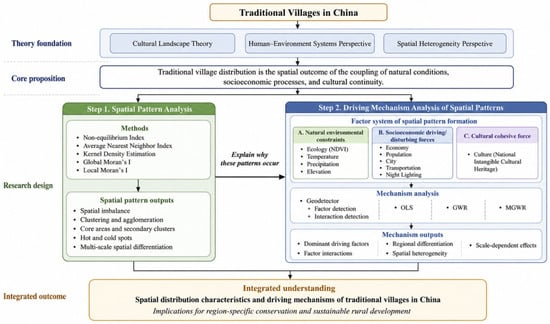
Drawing on cultural landscape theory and the human–environment systems perspective, this study conceptualizes traditional villages as living rural heritage systems formed through long-term interactions among natural environments, socioeconomic processes, and cultural continuity [5,6,7]. Within this framework, the spatial distribution of traditional villages is not treated as a random arrangement of settlement points, but as a spatial outcome associated with three interrelated dimensions: natural environmental constraints, socioeconomic impact forces, and cultural cohesive forces (Figure 1).
Figure 1.
Map of Conceptual Framework.
Natural environmental conditions provide the basic suitability for settlement formation and long-term preservation. Ecological quality, hydrothermal conditions, and topographic settings are closely related to agricultural viability, water availability, living suitability, and relative exposure to external disturbance. Socioeconomic conditions represent dynamic contextual forces that may either support village continuity or intensify transformation pressure [16,38]. Economic development and population size reflect the material basis and demographic vitality of rural settlements, whereas urbanization and transportation accessibility indicate both development opportunities and potential external pressures [39,40]. Cultural endowment functions as an endogenous cohesive force that sustains place identity, historical continuity, and collective memory, and is represented in this study by the density of national intangible cultural heritage [20,36].
Following this conceptual logic, the research design proceeds in two steps. First, the spatial patterns of traditional villages in China are identified in terms of distribution imbalance, clustering characteristics, agglomeration cores, and local spatial differentiation. Second, the associations between traditional village density and natural, socioeconomic, and cultural conditions are examined, with particular attention to factor interactions, spatial heterogeneity, and scale-dependent relationships across different geographical contexts.
3.2. Data Sources, Variable Construction, and Spatial Preprocessing
This study used data from six official batches of Chinese traditional villages released between 2012 and 2023, comprising 8155 village point locations as the primary research objects. The village data were obtained from the official registers of Chinese traditional villages published by the Ministry of Housing and Urban-Rural Development of the People’s Republic of China (https://www.mohurd.gov.cn/). The geographic coordinates of village locations were extracted and converted into vector point data using OpenStreetMap. Provincial-level GDP, tertiary industry GDP, and population data were obtained from the China Statistical Yearbook. Additional raster datasets, including economic indicators, population distribution, ecological conditions, elevation, nighttime light intensity, road networks, watershed boundaries, geomorphology, and slope aspect, were acquired from the Resource and Environment Science Data Center (https://www.resdc.cn/). Climatic variables, including temperature and precipitation, were obtained from the National Earth System Science Data Center (https://www.geodata.cn/). Data on national intangible cultural heritage were collected from the five batches of Chinese intangible cultural heritage lists officially recognized by the State Council and recorded in the China Intangible Cultural Heritage Network and Digital Museum (https://www.ihchina.cn/). The geographic coordinates of these heritage items were also extracted using OpenStreetMap to generate vector point data. County-level and above urban node data were also obtained from OpenStreetMap.
The basic analytical unit of this study was a 1 km × 1 km grid, which was used for data aggregation, dataset construction, and spatial analysis. The 50 km × 50 km grid was used only for cartographic visualization. To ensure spatial comparability across multi-source datasets, all spatial data were projected into a unified coordinate system and harmonized to a common 1 km × 1 km spatial resolution. Raster datasets, including NDVI, temperature, precipitation, elevation, nighttime lighting, population, and economic layers, were resampled to this resolution. Continuous variables were processed using bilinear interpolation, while discrete or categorical datasets were processed using nearest-neighbor resampling where necessary.
Variables were constructed according to their measurement properties. Mean values were used for variables representing average environmental conditions, such as NDVI, temperature, elevation, and nighttime lighting, whereas sum or density values were used for variables representing total amount or intensity, such as precipitation, population, and GDP. Point data, including traditional villages, national intangible cultural heritage items, and county-level and above urban nodes, were summarized within 1 km grid cells using spatial joins. Road network data were calculated as the total road length within each 1 km grid. Traditional village density was calculated as the number of villages per unit grid area. As the analytical variables were constructed at the 1 km grid scale, the results should be interpreted as grid-level spatial associations rather than village-level causal effects.
Based on the processed grid dataset, village density was selected as the dependent variable to represent the spatial agglomeration intensity of traditional villages. Because traditional villages are point-based heritage units, simple village counts are sensitive to the size of spatial units, while binary presence–absence variables and distance-based measures cannot adequately reflect clustering intensity. Therefore, the number of traditional villages per unit grid area was used to provide a comparable measure of regional concentration. The explanatory variables were operationalized at the same grid scale. NDVI was used to represent ecological suitability because it reflects vegetation condition and environmental quality. Temperature and precipitation were used to characterize hydrothermal conditions related to historical agricultural viability and living suitability, while elevation was used to capture topographic constraints and relative isolation. GDP and population were used to describe regional development capacity and demographic support. Urban-related conditions were represented by the density of county-level and above urban nodes, which reflects external urbanization pressure rather than internal village urbanization. Cultural cohesion was represented by the density of national intangible cultural heritage, as this indicator reflects cultural continuity, collective memory, and place-based identity.
Transportation was measured by the total length of road networks within each grid, which was used to represent external transport connectivity and potential accessibility at the grid scale. Road length was selected instead of road network density or travel time for two reasons. First, because all analytical grids have the same area, total road length has the same representational meaning as road density under a fixed grid scale and is more convenient for calculation and comparison with other gridded variables. Second, travel-time indicators require detailed and nationally consistent data on road hierarchy, road quality, travel speed, traffic conditions, and topographic barriers, which are difficult to standardize at the national scale. Nighttime lighting data were not used as a final explanatory variable for village-level development. This is mainly because most traditional villages are located in rural, mountainous, or peripheral areas, where nighttime light intensity is generally weak and unstable, making it difficult to accurately reflect development conditions at the village scale. In addition, although nighttime lighting can indirectly represent regional economic activity and human activity intensity, its information overlaps to some extent with the GDP, population, and urban node variables already included in this study, which may increase the risk of multicollinearity (Table 1).
Table 1.
Factors influencing traditional villages and calculation methods.
3.3. Spatial Pattern Identification
This study used the non-equilibrium index, average nearest-neighbor index, kernel density estimation, and spatial autocorrelation analysis to identify the spatial distribution patterns of traditional villages. These methods serve different but complementary purposes. The non-equilibrium index was used to measure provincial-level distribution imbalance; the average nearest-neighbor index was used to determine whether village points were clustered, random, or dispersed; kernel density estimation was used to identify high-density agglomeration areas; and global and local Moran’s I were used to detect spatial autocorrelation, hot spots, cold spots, and local clustering patterns.
The non-equilibrium index was used to evaluate the unevenness of traditional village distribution across provinces [41]. It is calculated as:
where represents the province count, and denotes the cumulative percentage of traditional villages in th province. The unbalanced index, S, ranges between 0 and 1, where greater values signify a greater degree of uneven traditional village distribution across provinces.
The average nearest neighbor index (ANN) was used to identify the point distribution pattern of traditional villages [32]. It compares the observed average nearest neighbor distance with the expected average distance under a random distribution. The model is expressed as:
where denotes the average nearest neighbor index, signifies the observed average distance, denotes the expected average distance, corresponds to the traditional village count, and indicates the study region area. Based on the calculation outcomes, , and correspond to discrete or uniform, random, and clustered traditional village distribution patterns, respectively.
Kernel density estimation was used to identify agglomeration cores and characterize the continuous density surface of traditional villages [26]. The model is expressed as:
where represents the kernel density estimation function; signifies the bandwidth parameter, which regulates the smoothing level applied; indicates the traditional village count within the bandwidth; corresponds to the kernel function; and indicates the estimation point’s distance to the th point situated within the bandwidth.
This study further identified primary core areas and secondary nodes based on kernel density estimation and local spatial association results. The density values derived from kernel density estimation were classified using the natural breaks method. Contiguous zones within the highest density class were identified as primary core areas, while statistically significant high-density clusters outside these primary cores were identified as secondary nodes. For each primary core area, the number of villages, spatial extent, village density, and share of the national total were calculated. This procedure enables the spatial pattern to be interpreted not only through visual inspection, but also through comparable quantitative indicators.
Spatial autocorrelation analysis was used to examine whether traditional village density exhibits significant spatial dependence at the grid level [42]. Global Moran’s I was used to measure overall spatial autocorrelation:
where , represents overall spatial unit count, with and denoting attribute values of th and th spatial units, respectively. The symbol refers to the mean attribute value across all spatial units, and represents the spatial weight matrix. The global Moran’s I index spans between −1 and 1. Positive values signify positive spatial autocorrelation, where those closer to 1 indicate a strong clustering of similar attribute values in space. Conversely, negative values indicate negative spatial autocorrelation, with values approaching −1 reflecting a spatial clustering of dissimilar attribute values.
Local Moran’s I was used to identify local spatial association patterns, including high–high clusters, low–low clusters, low–high outliers, and high–low outliers [43]. The corresponding model is expressed as follows:
where denotes the local Moran’s I index of th spatial cell; is the variance of the observations, and other symbols have the same meaning as above. A first-order queen contiguity matrix was used to define spatial adjacency among grid cells, and the weights were row-standardized. The LISA cluster map was generated to identify local hot and cold spots of traditional village density.
3.4. Impact Factors Analysis
To examine the factors associated with the spatial distribution of traditional villages, this study combined Optimal Geodetector analysis with spatial regression model comparison. Optimal Geodetector was used to assess spatial stratified heterogeneity and the explanatory power of selected variables, while OLS, GWR, and MGWR were compared to evaluate spatial non-stationarity and scale-dependent relationships. Geodetector is a statistical method for detecting spatial stratified heterogeneity and measuring the explanatory power of associated factors [25,26]. In this study, factor detection was used to evaluate the independent explanatory power of each variable for traditional village density, while interaction detection was used to examine whether the interaction between two variables enhanced or weakened their explanatory power compared with their individual effects. The q-statistic is expressed as:
where represents the explanatory power of a given factor for the spatial differentiation of traditional village density, while signifies the stratification level of the factor . Here, and denote the number of cells within stratum and overall study area, respectively. Similarly, and denote the variance of the dependent variable within stratum and overall region, respectively. ranges between 0 and 1, with greater signifying more explanatory power of factor on the dependent variable .
Because Geodetector requires categorical independent variables, continuous variables were discretized before analysis. To improve reproducibility and reduce subjectivity, this study adopted an optimal discretization procedure. Four discretization methods were tested for each continuous variable: equal interval, natural breaks, quantile, and geometric interval. For each method, the number of classes was set from 4 to 8. The optimal discretization scheme was selected based on the maximum q value under statistical significance. The selected discretization method, number of classes, q value, and p value were recorded for each variable. This procedure reduces the potential arbitrariness of arbitrary classification and improves the reproducibility of the Geodetector results.
OLS, GWR, and MGWR were then used to further examine the spatial associations between traditional village density and the explanatory variables. OLS was used as a global baseline model. Before spatial regression, multicollinearity was assessed using the variance inflation factor (VIF), and variables with acceptable VIF values were retained. Heteroscedasticity was examined using the Breusch–Pagan test or White test. GWR was used to account for spatial non-stationarity by estimating local regression coefficients.
However, conventional GWR applies a single bandwidth to all explanatory variables, which may be insufficient when different factors operate at different spatial scales. MGWR addresses this limitation by estimating variable-specific bandwidths and is therefore suitable for identifying scale-dependent spatial associations in geographic data [44]. In this study, MGWR was used to examine how the relationships between traditional village density and associated factors vary across space and across spatial scales. The model is formulated as follows:
Let denote the value of the dependent variable at the th observation, and let represent the th independent variable corresponding to the th observation; is the regression coefficient of the independent variables at the spatial location ; and is the independently and identically distributed random error term.
The bandwidth of each explanatory variable was optimized using the corrected Akaike information criterion (AICc), and the golden section search algorithm was used for automatic bandwidth selection. An adaptive bi-square kernel function was applied to account for the uneven spatial distribution of village points. Model performance was compared using AICc, R2, adjusted R2, and the spatial autocorrelation of residuals. A lower AICc and a higher adjusted R2 indicate better model performance. Through this comparison, the study evaluated whether MGWR provides a more appropriate representation of spatially heterogeneous and scale-dependent associations than OLS and conventional GWR.
4. Research Results
4.1. Spatial Pattern and Diversity Evolution of Traditional Villages
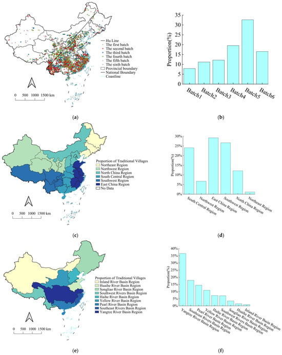
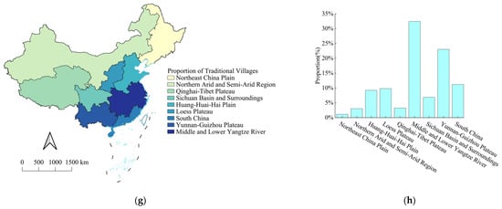
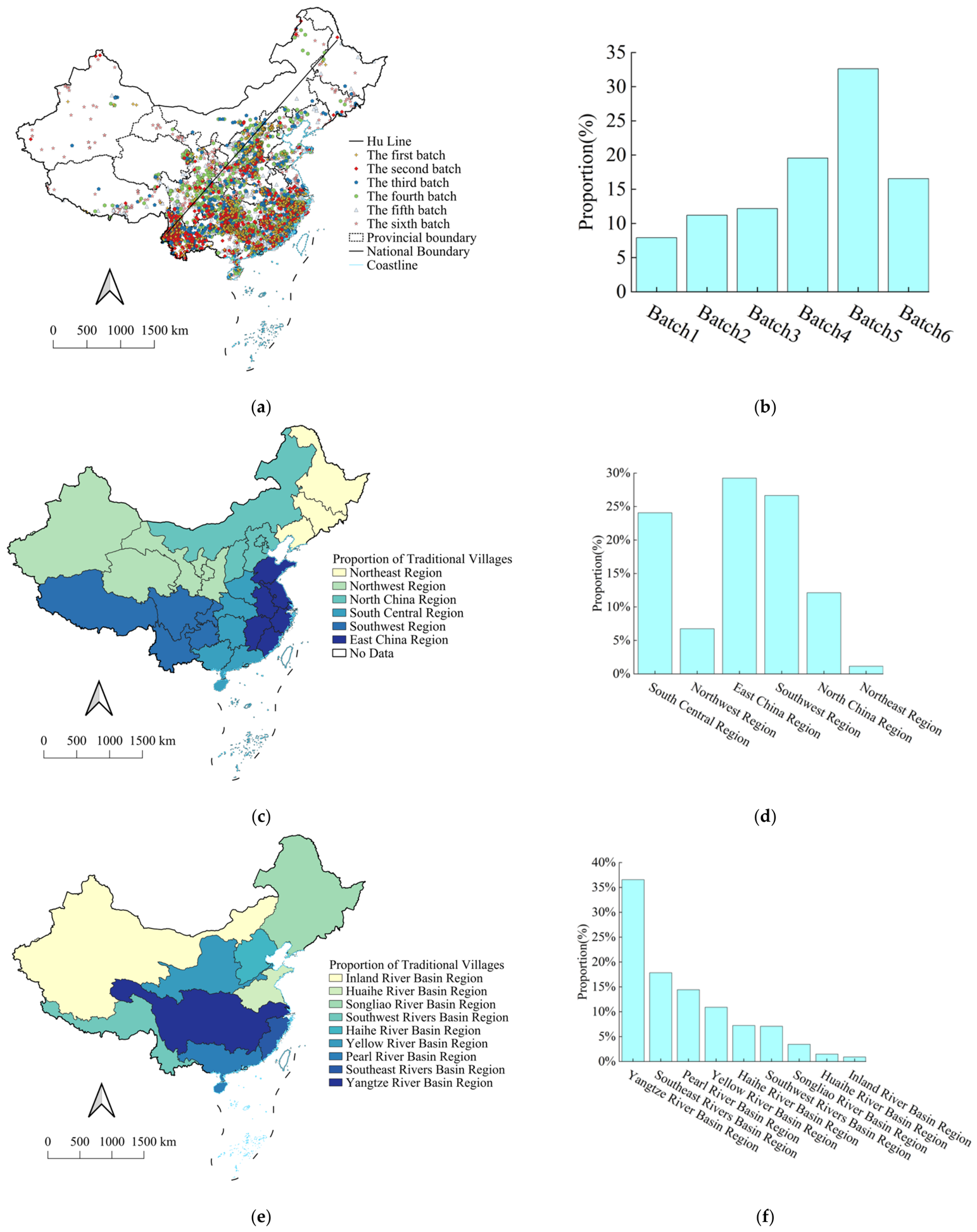
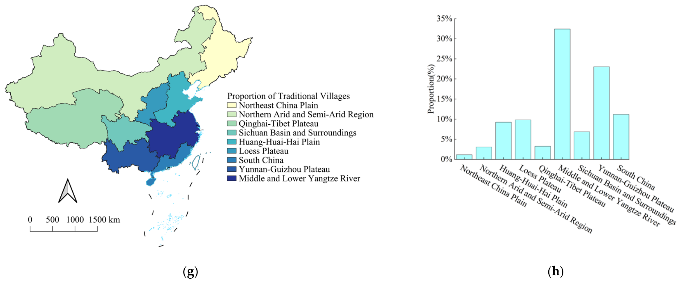
The spatial distribution of traditional villages in China exhibits a pronounced pattern of regional imbalance, with higher concentrations in southern and eastern China and much lower concentrations in northern and western China. At the national scale, the Hu Huanyong Line represents a major spatial divide: 94.2% of traditional villages are located to the east of the line, whereas only 5.8% are located to the west. At the provincial scale, Yunnan, Guizhou, Hunan, Zhejiang, and Shanxi contain 3552 traditional villages, accounting for 43.56% of the national total. In contrast, Shanghai, Tianjin, Jilin, Beijing, and Heilongjiang contain only 88 villages, accounting for 1.08%. Regionally, Southwest China has the largest number of traditional villages, whereas Northeast China has the smallest number. From the perspective of major river basins, traditional villages are most densely concentrated in the Yangtze River Basin, while the Songliao Basin and the inland basins of arid northwestern China show much sparser distributions. Overall, these results indicate that traditional villages in China are highly uneven in their national distribution. The eastern side of the Hu Huanyong Line, especially Southwest China and the Yangtze River Basin, constitutes the main concentration area of China’s traditional village heritage (Figure 2).
Figure 2.
(a,b) Traditional villages’ spatial distribution patterns. (c,e,g) Distribution of traditional villages across various geographical regions. (d,f,h) The quantitative distribution of traditional villages within distinct geographical zones.
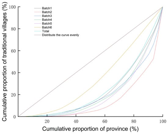
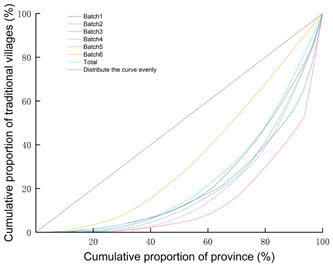
The non-equilibrium index and Lorenz curve further confirm the uneven spatial distribution of traditional villages. The overall national non-equilibrium index is 0.5224, indicating a clear imbalance in provincial distribution. Among the six batches, the second batch has the highest non-equilibrium index (0.7247), suggesting the strongest provincial concentration, whereas the sixth batch has the lowest value (0.3196), indicating a relatively more balanced distribution. The Lorenz curves of all batches deviate from the line of perfect equality, providing further graphical evidence that traditional villages are unevenly distributed across provinces (Figure 3).
Figure 3.
Non-equilibrium index Lorenz curve.
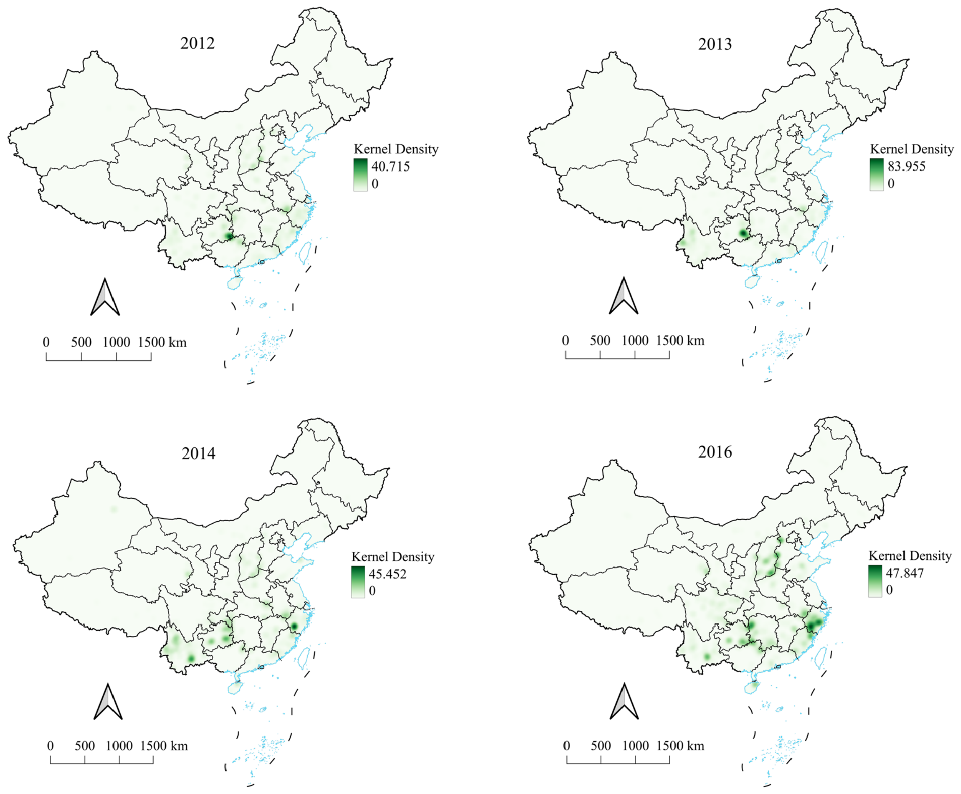
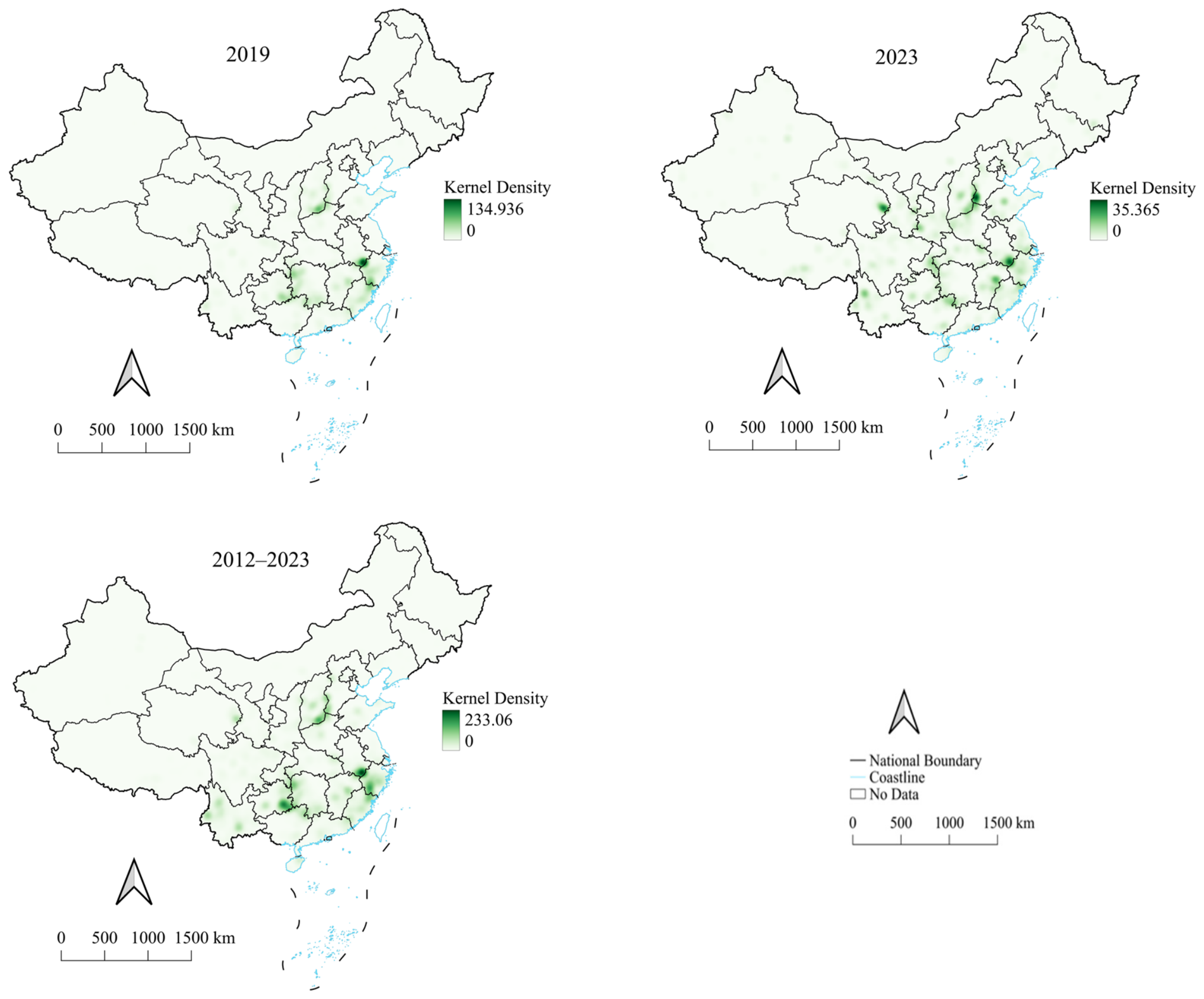
Kernel density estimation identifies a clear “three-core and multi-node” spatial structure. The three major high-density cores are located in the Anhui–Jiangxi–Zhejiang border region, the Hunan–Guizhou–Guangxi border region, and the Shanxi–Hebei–Henan Taihang Mountain region. Among them, the Anhui–Zhejiang–Jiangxi hilly region shows the strongest agglomeration, covering approximately 132,000 km2 and reaching a density of 58.7 villages per 10,000 km2. The Hunan–Guizhou–Guangxi region follows with 47.6 villages per 10,000 km2, while the Taihang Mountain region has a density of 32.4 villages per 10,000 km2. These core areas show an outward decline in density, forming a three-level structure of core zones, transition zones, and edge zones. This pattern suggests that high-density agglomerations of traditional villages are closely associated with long-term settlement history, favorable environmental conditions, regional cultural accumulation, and relatively continuous heritage preservation contexts (Figure 4).
Figure 4.
Kernel density map illustrating traditional villages’ spatial distribution.
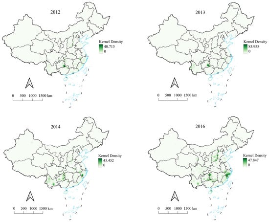
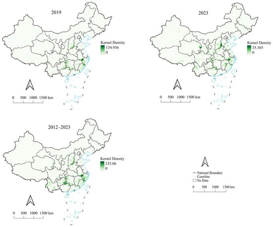
The batch-based kernel density results show that the spatial composition of officially recognized traditional villages has shifted from localized agglomeration toward a more stable multi-core structure. The first batch already reflects the basic national pattern and the initial emergence of the three-core structure. The second batch is strongly concentrated in the Hunan–Guizhou–Guangxi border region, while the third and fourth batches show greater concentration in the Zhejiang–Fujian and southern Zhejiang regions. The fifth batch further strengthens the Anhui–Jiangxi–Zhejiang core, and the sixth batch presents a relatively stable three-core structure. Overall, the results indicate that traditional villages in China are highly unevenly distributed and that official recognition has gradually expanded from local clusters toward a more mature multi-core pattern.
4.2. Spatial Clustering and Spatial Autocorrelation
Utilizing the Average Nearest Neighbor (ANN) index tool within the QGIS v3.3 software to analyze data pertaining to 8155 Chinese traditional villages, the p-values associated with the ANN consistently approach zero. The analysis reveals that the overall ANN for traditional villages across batches 1 through 6 is 0.3335, signifying a general tendency toward spatial clustering. The ANN values of the remaining batches generally show a pattern of first increasing and then decreasing. These results confirm the spatial clustering effect of traditional villages, while also indicating that the clustering intensity varies across different recognition batches (Table 2).
Table 2.
ANN for traditional villages.
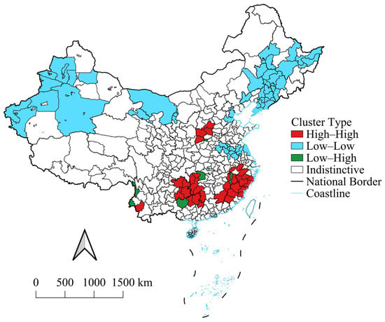
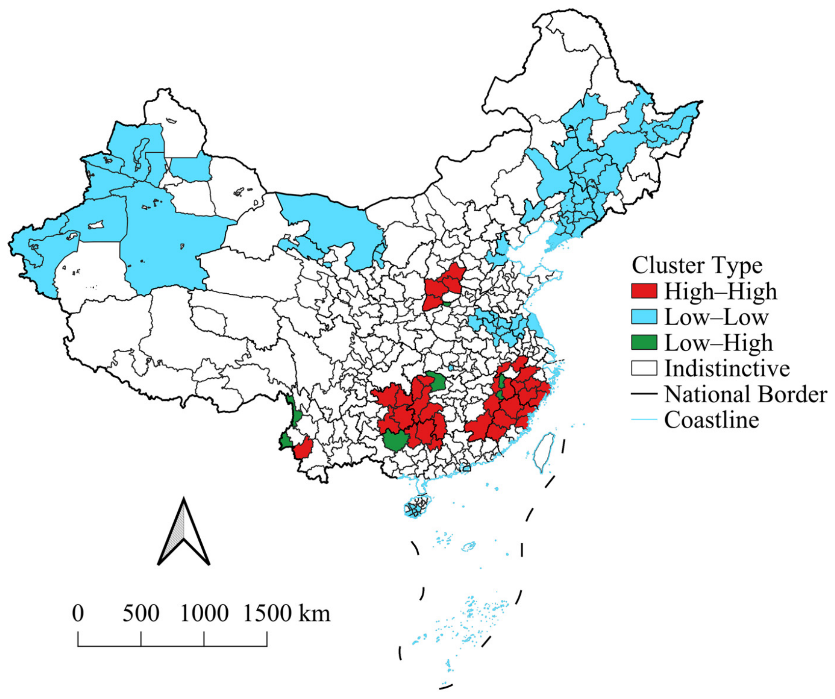
Global and local spatial autocorrelation analyses were implemented using QGIS v3.3 and GeoDa v1.14 software to systematically characterize the spatial dependence and clustering patterns of traditional village distribution across China, with all quantitative results summarized in Table 3 and the spatial distribution of clusters visualized in Figure 5. Statistically, the global Moran’s I index for traditional village density was calculated as 0.715 and a p-value less than 0.001, confirming a pronounced positive spatial autocorrelation in the distribution of traditional villages nationwide, while all nine selected influencing factors also yielded significantly positive global Moran’s I indices with all p-values below 0.001, demonstrating that the impact forces themselves exhibit strong spatial clustering characteristics.
Table 3.
Value of Moran’s I for traditional villages.
Figure 5.
LISA cluster map of traditional villages.
Local Moran’s I and the LISA cluster map reveal a clear core–periphery structure. High–High clusters are mainly located in the Fujian–Zhejiang–Jiangxi border region and the Hunan–Guizhou–Guangxi border region, with smaller clusters in southern Shanxi and southwestern Yunnan. Low–Low clusters are mainly distributed in Northeast China and western Xinjiang, reflecting extensive low-density areas. Low–High clusters occur primarily in transition zones around high-density clusters, indicating spatial transition between core agglomerations and their surrounding areas. Together, the results demonstrate that traditional villages in China exhibit significant clustering at both national and local scales, with high-density clusters concentrated mainly in southeastern and southwestern China.
4.3. Explanatory Power and Interaction Effects of Influencing Factors
The Geodetector results show that all selected factors are significantly associated with the spatial differentiation of traditional village density at the p < 0.001 level. Among the single factors, temperature has the highest explanatory power (q = 0.6592), followed closely by precipitation (q = 0.6560). Ecological quality also shows relatively strong explanatory power (q = 0.1986), followed by cultural endowment (q = 0.1066), urbanization (q = 0.0977), economy (q = 0.0629), elevation (q = 0.0534), population (q = 0.0120), and transportation (q = 0.0097) (Table 4).
Table 4.
Detection results.
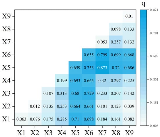
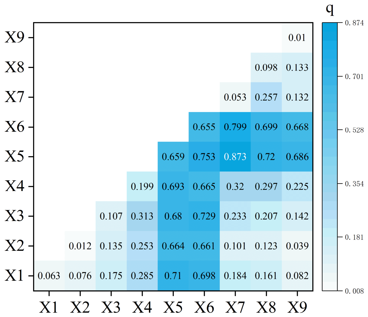
The interaction detection results further show that the explanatory power of paired factors is generally higher than that of individual factors. The strongest interaction appears between elevation and temperature, with a q-value of 0.8732. The interaction between temperature and precipitation also shows strong explanatory power (q = 0.7531), while the interaction between culture and precipitation reaches 0.729. In addition, the explanatory power of transportation increases substantially when interacting with temperature. Overall, the Geodetector results indicate that the spatial differentiation of traditional village density is also associated with a single condition alone, but with the combined effects of hydrothermal conditions, topographic setting, cultural endowment, and accessibility-related factors. Temperature and precipitation play the most important single-factor roles, while factor interactions reveal a clear nonlinear enhancement effect, highlighting the comprehensive nature of traditional village distribution (Figure 6).
Figure 6.
Interaction results.
4.4. MGWR Model Comparison and Spatial Heterogeneity of Associations
Before spatial regression modeling, multicollinearity was tested using the variance inflation factor. The VIF values of all explanatory variables range from 1.27 to 2.75, all below the commonly used threshold of 7.5, indicating no severe multicollinearity among the selected variables (Table 5). The comparison among OLS, GWR, and MGWR shows that the MGWR model performs much better than the global OLS and GWR models (Table 6).
Table 5.
Results of heteroscedasticity test.
Table 6.
MGWR results.
The MGWR bandwidth results indicate that different variables are associated with traditional village density at different spatial scales. Elevation has the largest bandwidth (1744), followed by urbanization, with a bandwidth of 564. Ecology, precipitation, and transportation show medium bandwidths, whereas temperature, economy, population, and cultural endowment have relatively small bandwidths of 40, 44, 46, and 50, respectively.
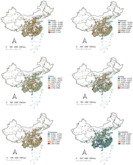
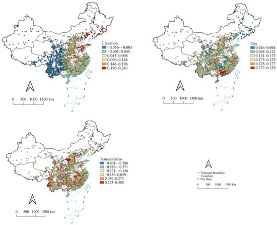
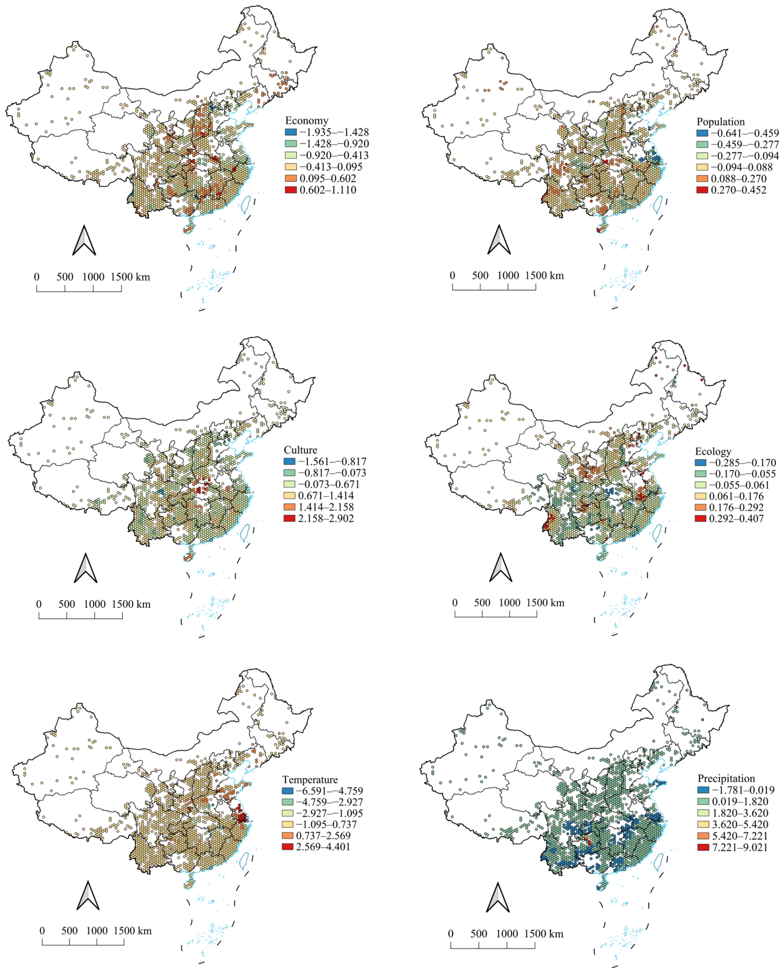
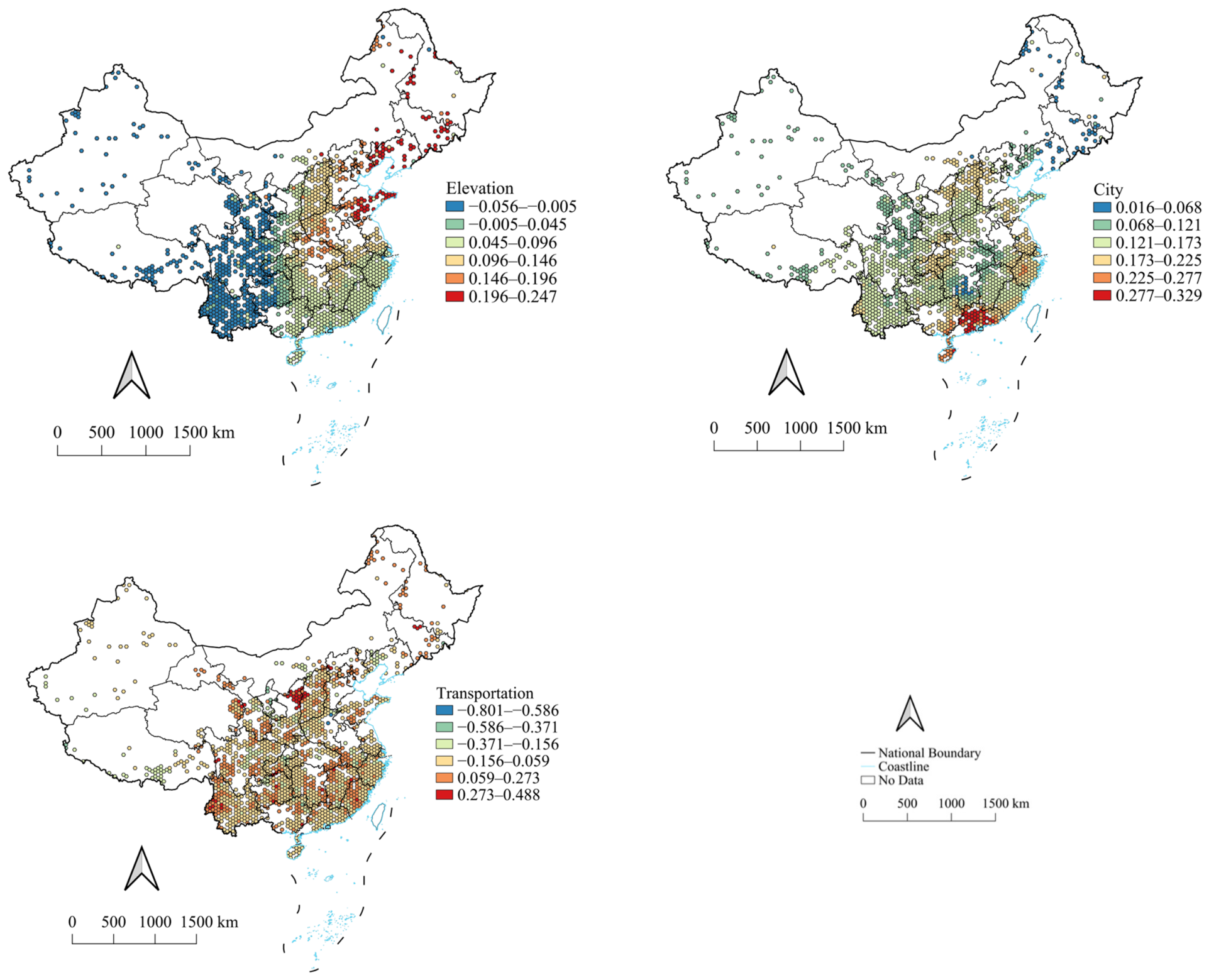
The MGWR coefficient maps further reveal clear regional differences in the direction and magnitude of factor–density relationships. Among natural environmental variables, temperature is mainly negatively associated with traditional village density in southern China, especially in warmer subtropical and tropical regions, while weak positive associations appear in parts of northern China. This result should not be interpreted as a simple inhibitory effect of higher temperature. Instead, it may reflect the concentration of traditional villages in relatively cooler mountainous or hilly areas within warm climate regions, as well as the combined associations among temperature, elevation, and historical settlement adaptation. Precipitation shows stronger positive associations in humid southeastern and southwestern China, while weak or negative associations appear in arid and semi-arid regions. Ecological quality, represented by NDVI, is generally positively associated with traditional village density across most regions, with stronger positive associations in South China and Southwest China.
Socioeconomic variables show more context-dependent associations. Economic development is negatively associated with traditional village density in major coastal urban agglomerations, including the Yangtze River Delta, Pearl River Delta, and Beijing–Tianjin–Hebei region, but weakly positive in some peripheral regions of Southwest and Northwest China. Population density is positively associated with traditional village density in central and southern China, especially in the Hunan–Guizhou–Guangxi and Anhui–Jiangxi–Zhejiang clusters, but negative associations appear in parts of Northeast and Northwest China. Urbanization, measured by county-level and above urban nodes, shows a generally positive association around traditional village clusters, which may reflect the historical co-location of traditional settlements with regional settlement networks. Transportation shows negative associations in developed eastern regions and weak positive associations in remote mountainous regions, indicating that transport connectivity may have different meanings under different regional development contexts: in developed regions, dense road networks may be associated with urban expansion, land-use conversion, and stronger transformation pressure, whereas in remote mountainous areas, basic road connectivity may support accessibility, public services, and heritage conservation.
Cultural endowment, measured by the density of national intangible cultural heritage, is positively associated with traditional village density in the main agglomeration regions, especially in the Anhui–Jiangxi–Zhejiang border region, where the coefficient reaches its highest value. This result indicates a close spatial correspondence between traditional villages and areas with rich cultural resources.
Taken together, the MGWR results indicate that the relationships between explanatory variables and traditional village density vary substantially across geographical contexts. Temperature, economy, transportation, and cultural endowment show particularly evident regional differences in direction and magnitude. These findings confirm that traditional village distribution is shaped by scale-dependent and spatially heterogeneous associations rather than by uniform national relationships. Therefore, the spatial differentiation of traditional village density should be interpreted through the combined effects of broad-scale environmental settings, local socioeconomic conditions, transport accessibility, and cultural continuity (Figure 7).
Figure 7.
Spatial Coefficient Distribution Maps of MGWR.
5. Discussion
5.1. Spatial Distribution Pattern of Traditional Villages in China
The results show that traditional villages in China have a highly uneven spatial distribution and form a clear “three-core and multi-node” pattern at the national scale. The three major high-density cores are located in the Anhui–Jiangxi–Zhejiang border region, the Hunan–Guizhou–Guangxi border region, and the Shanxi–Hebei–Henan Taihang Mountain region. Secondary clusters are distributed in southwestern Yunnan, the southeastern coastal region, central Jiangxi, eastern Qinghai, and central Sichuan. This pattern indicates that traditional villages are not randomly distributed, but are concentrated in regions with long settlement histories, relatively suitable environmental conditions, and strong cultural accumulation.
This finding is generally consistent with previous studies, which have shown that traditional villages tend to display significant spatial clustering rather than even distribution [45]. Many regional studies have also found that traditional villages are more likely to be concentrated in mountainous and hilly areas, river valleys, historical–cultural regions, and areas with rich cultural heritage. These findings are broadly in line with the three core regions identified in this study. For example, the Anhui–Jiangxi–Zhejiang region has long been characterized by dense historical settlements, strong lineage culture, and rich vernacular architectural traditions; the Hunan–Guizhou–Guangxi region contains diverse traditional cultures and mountainous settlement landscapes; and the Shanxi–Hebei–Henan Taihang Mountain region reflects the combined influence of mountain environments, historical routes, and northern vernacular settlement traditions.
However, there are also differences between this study and some previous regional findings. Earlier studies focusing on single provinces, river basins, karst areas, or specific cultural regions often identified patterns such as “single-core”, “dual-core”, “one core with multiple points”, or belt-like distributions. These differences do not necessarily indicate contradictory conclusions. Rather, they are largely related to differences in research scale and spatial scope. Local or regional studies can capture more detailed settlement characteristics within a specific geographical context, while national-scale analysis reveals how these local clusters are embedded within a broader spatial hierarchy. From this perspective, many regional patterns identified in previous studies can be understood as components of the national “three-core and multi-node” structure [46,47].
The difference may also be related to data coverage and analytical perspective. Many previous studies used provincial or regional samples, whereas this study uses all 8155 national-level traditional villages across six official batches. The inclusion of multiple batches allows the spatial composition of official recognition to be examined more comprehensively. The batch-based results suggest that the recognition of traditional villages has gradually expanded from highly concentrated heritage-rich areas to a broader and more stable multi-core pattern. Therefore, the national spatial pattern identified in this study reflects not only the historical distribution of traditional villages, but also the cumulative outcome of official recognition and protection processes.
Overall, the spatial distribution pattern revealed in this study is consistent with the clustering tendency reported in existing research, but it further shows how different local and regional clusters are organized within a national spatial hierarchy. The “three-core and multi-node” structure should therefore be understood as a scale-dependent spatial pattern: at the local scale, traditional villages may appear as single-core, dual-core, or belt-like clusters, whereas at the national scale these clusters jointly form a multi-core hierarchical distribution.
5.2. Influencing Factors and Spatially Heterogeneous Associations
The results suggest that the spatial differentiation of traditional village density is associated with three interrelated dimensions: natural environmental constraints, cultural cohesion, and socioeconomic transformation. Climatic and ecological variables show the strongest explanatory power in the Geodetector results, which is consistent with previous studies emphasizing the importance of temperature, precipitation, elevation, hydrology, vegetation, and other natural conditions in traditional village distribution [9,48]. These variables are closely related to agricultural suitability, water availability, living conditions, and the relative stability of rural settlement environments.
The negative association between temperature and traditional village density in parts of southern China requires careful interpretation. It should not be understood as evidence that higher temperature directly reduces traditional village density. A more plausible explanation is that, within warm and humid regions, traditional villages are often concentrated in relatively cooler hilly and mountainous environments rather than hotter lowland areas. Such areas may have historically provided more stable microclimates, lower flood exposure, stronger defensive conditions, and less disturbance from later urban expansion. The temperature coefficient may therefore reflect the spatial coupling of temperature, elevation, moisture conditions, and historical settlement adaptation, rather than the independent effect of temperature alone.
Cultural endowment is positively associated with traditional village density in the main agglomeration regions. This finding supports the view that traditional villages are not only physical settlements, but also spatial carriers of collective memory, local identity, ritual practice, and living heritage [18,36,37]. The spatial correspondence between traditional villages and national intangible cultural heritage suggests that areas with stronger cultural accumulation may also have stronger conditions for the persistence of traditional village identity. However, national intangible cultural heritage represents formally recognized cultural resources and cannot fully capture informal traditions, everyday practices, community participation, or the actual vitality of local culture. Therefore, the cultural variable should be understood as an institutionalized proxy for cultural endowment rather than a complete measure of cultural continuity.
Socioeconomic variables and transportation show more context-dependent associations. Economic development is negatively associated with traditional village density in major coastal urban agglomerations, but weakly positive in some peripheral regions. This contrast may reflect different regional development contexts. In highly urbanized regions, stronger economic activity may correspond to land-use conversion, redevelopment pressure, and the weakening of traditional settlement environments. In peripheral or mountainous regions, moderate economic development may provide infrastructure, public services, and financial support for heritage conservation. However, this study does not directly measure industrial structure, heritage investment, tourism intensity, or local planning regulations. Therefore, the regional differences in economic associations should be regarded as indicative patterns rather than definitive evidence of development mechanisms.
Transportation also has differentiated meanings across regions. In developed eastern regions, denser road networks may correspond to external disturbance and spatial transformation, while in remote mountainous regions, road connectivity may provide basic access to services and protection resources. This differs from some local studies that emphasize the positive role of transportation improvement [49,50]. The difference may arise because local studies often examine areas where accessibility is the main constraint, whereas a national-scale analysis also captures regions where dense transport networks are associated with urban expansion and land-use change. Transportation should therefore not be understood as uniformly beneficial or harmful; its association with traditional village density depends on regional development stage, terrain conditions, and protection pressure.
Based on these findings, this study proposes a hierarchical interpretation framework for traditional village distribution. Natural environmental conditions provide the basic suitability for settlement formation and preservation; cultural cohesion supports the continuity of identity, memory, and heritage practices; and socioeconomic development and transportation accessibility act as contextual modifiers. These modifiers may support conservation through resources and connectivity, or intensify transformation through urban expansion, commercialization, and land-use change. This framework helps move the discussion beyond isolated variables and emphasizes the layered interaction among natural, cultural, socioeconomic, and accessibility-related conditions. In this sense, the contribution of MGWR is not only methodological, but also it helps reveal that traditional village distribution is a multi-scale spatial process in which different factors operate at different spatial ranges and under different regional contexts.
5.3. Strengths, Limitations, and Uncertainties
The main strength of this study lies in its national-scale coverage and integrated spatial analytical framework. By using all 8155 officially recognized traditional villages, the study provides a more complete understanding of the national spatial hierarchy of traditional village distribution than many previous regional studies [26,27,28,29]. The combined use of spatial pattern analysis, Geodetector, and MGWR makes it possible to identify spatial clustering, factor interactions, and spatially varying associations within a unified framework. This provides both a conceptual and empirical contribution: conceptually, it interprets traditional villages as a multi-scale rural heritage system; empirically, it reveals how national core areas, regional clusters, and local associations are linked within the same analytical framework. The study also has practical value for sustainable conservation. Identifying the core agglomeration areas, transition zones, and peripheral low-density regions provides spatial evidence for differentiated protection and planning. The results can support heritage zoning, regional cultural landscape conservation, infrastructure planning, tourism management, and rural revitalization policies. They also help connect traditional village protection with broader sustainability goals, including cultural diversity, ecological landscape management, climate adaptation, and sustainable rural livelihoods.
However, several limitations and uncertainties should be acknowledged. First, the findings of this study should be interpreted as spatial associations rather than causal relationships. The analysis is based on an observational and cross-sectional spatial design, which can reveal spatial clustering, factor associations, and spatial heterogeneity, but cannot directly identify causal mechanisms. For example, the associations between traditional village density and variables such as urbanization, transportation, economic development, and cultural endowment indicate spatial correspondence rather than confirmed causal effects. Establishing causality would require longitudinal data, policy shocks, natural experiments, or other causal inference approaches [51]. Second, although the national grid-based framework improves comparability across regions, it may obscure local and village-level processes. Traditional village preservation is closely related to household decisions, community governance, architectural maintenance, tourism participation, heritage investment, and local planning enforcement. These micro-scale processes cannot be fully captured by national raster data or grid-level indicators. Therefore, the results should be understood as national-scale and grid-level patterns, rather than direct explanations of village-level change. Third, the proxy variables used in this study involve certain measurement uncertainties. NDVI reflects vegetation condition but cannot fully represent ecological quality or habitat stability. National intangible cultural heritage captures formally recognized cultural resources, but may overlook local rituals, informal cultural practices, and community-based cultural vitality. Economic, population, and road data may also involve spatial aggregation errors or time-lag effects. Multi-scale nested analyses should be developed by combining national-scale modeling with county-level case studies, village surveys, field investigations, and historical document analysis. Longitudinal datasets could also be used to examine how urbanization, tourism development, transportation construction, land-use change, and conservation policies are associated with traditional village transformation over time. In addition, more refined indicators, such as road hierarchy, travel time, tourism intensity, heritage investment, community participation, planning regulation, and village-level cultural practices, should be incorporated to improve the explanation of local preservation and transformation processes.
5.4. Policy Implications for Sustainable Conservation
The findings provide practical implications for traditional village conservation and sustainable rural development. First, the “three-core and multi-node” pattern suggests that conservation should move beyond isolated village-level protection and adopt a regional cultural landscape perspective. In the Anhui–Jiangxi–Zhejiang, Hunan–Guizhou–Guangxi, and Taihang Mountain core regions, policies should focus on protecting contiguous traditional settlement networks, vernacular architectural landscapes, surrounding ecological environments, and regional cultural routes. Cross-county and cross-provincial coordination is especially important in these core agglomeration belts.
Second, differentiated conservation strategies should be formulated for different spatial zones. In core agglomeration areas, strict protection of village morphology, historical landscape integrity, and ecological surroundings should be prioritized, while excessive tourism commercialization and homogenized redevelopment should be controlled. In transition zones around the cores, policies should improve public services, strengthen community participation, and support appropriate cultural tourism under carrying-capacity constraints. In low-density or peripheral areas, especially in mountainous, and remote regions, conservation should focus on basic infrastructure, cultural documentation, prevention of village hollowing, and support for local livelihoods.
Third, the spatially heterogeneous associations of economy and transportation indicate that development-oriented policies need to be carefully calibrated. In highly urbanized regions, traditional villages require stronger land-use control, buffer-zone management, and restrictions on inappropriate redevelopment. In remote regions, moderate improvements in road access, public services, and digital infrastructure may support heritage protection and livelihood improvement, but such interventions should avoid triggering excessive commercialization or landscape disruption.
Finally, traditional village conservation should be linked to broader sustainability goals. Many traditional villages embody long-term adaptation to terrain, water resources, climate conditions, and local ecological constraints. Their protection can contribute to cultural diversity, rural revitalization, ecological landscape management, and climate adaptation. Therefore, conservation planning should not focus only on buildings or tourism development, but should integrate cultural heritage, ecological carrying capacity, community livelihoods, and regional planning. This approach can help transform traditional villages from protected heritage units into active components of sustainable rural development.
6. Conclusions
This study investigated the spatial distribution patterns and associated influencing factors of 8155 national-level traditional villages in China by integrating spatial pattern analysis, Geodetector, and MGWR. The findings provide a national-scale understanding of how traditional villages are spatially organized and how their distribution is associated with natural, cultural, and socioeconomic conditions.
First, traditional villages in China show a highly uneven and clustered spatial distribution. The Hu Huanyong Line, non-equilibrium index, Lorenz curve, average nearest neighbor index, and kernel density estimation consistently indicate strong spatial imbalance and agglomeration. The national pattern is characterized by a “three-core and multi-node” structure, with three major high-density cores located in the Anhui–Jiangxi–Zhejiang, Hunan–Guizhou–Guangxi, and Shanxi–Hebei–Henan regions, and secondary clusters in southwestern Yunnan, the southeastern coastal zone, central Jiangxi, eastern Qinghai, and central Sichuan. These results suggest that traditional villages are more likely to be concentrated in regions where suitable environmental conditions, long settlement histories, and cultural accumulation overlap.
Second, the Geodetector results show that the spatial differentiation of traditional village density is more strongly associated with hydrothermal conditions than with other single factors. Temperature and precipitation have the highest single-factor explanatory power, while ecological quality and cultural endowment also show meaningful associations. By contrast, economy, population, urbanization, elevation, and transportation show relatively weaker single-factor explanatory power. However, interaction detection indicates that the explanatory power of paired factors is generally enhanced, especially for combinations involving elevation, temperature, precipitation, and cultural endowment. These findings suggest that traditional village distribution should be interpreted through factor combinations and spatial stratified heterogeneity rather than through isolated variables.
Third, the MGWR results reveal clear spatial heterogeneity and scale-dependent associations between explanatory variables and traditional village density. The bandwidth results show that different variables operate at different spatial ranges: elevation and urbanization show broader-scale associations, whereas temperature, economy, population, and cultural endowment display more localized associations. The coefficient results further indicate that temperature, economy, transportation, and cultural endowment vary noticeably across regions in both direction and magnitude. These findings confirm that the relationships between traditional village density and associated factors are not spatially uniform, and that national-level averages may obscure important regional differences.
Overall, this study contributes to traditional village research by linking national-scale spatial pattern identification, factor interaction detection, and multiscale spatial regression within an integrated analytical framework. The findings support differentiated conservation strategies: core agglomeration areas should emphasize regional cultural landscape protection; transition zones should promote controlled development and community participation; and peripheral areas should strengthen infrastructure support, cultural documentation, and livelihood improvement. These insights can help integrate traditional village conservation with rural revitalization, cultural heritage protection, ecological landscape management, and sustainable rural development.
Author Contributions
Conceptualization, T.S. and X.D.; methodology, T.S.; Data curation, H.H.; formal analysis, J.L.; investigation, X.D.; resources, H.H.; software, H.H.; Writing—original draft, T.S. and H.H.; Writing—review and editing, X.D. and J.L.; All authors have read and agreed to the published version of the manuscript.
Funding
This research was supported by grants from the National Natural Science Foundation of China (No. 42361034), the National Natural Science Foundation of China (No. 52562045), and the Natural Science Foundation of Xinjiang Uygur Autonomous Region (No. 2024D01A110).
Institutional Review Board Statement
Not applicable.
Informed Consent Statement
Not applicable.
Data Availability Statement
The data used to support the findings of this study are available from the corresponding authors upon request.
Conflicts of Interest
The authors declare no conflicts of interest.
References
- Wang, F.; Zhao, X.; Qiu, Y.; Luo, J. Adaptability of Traditional Villages as Tourist Destinations in Yellow River Basin, China. Indoor Built Environ. 2023, 32, 574–589. [Google Scholar]
- Wang, F.; Wang, S.; Cheng, B.; Wang, W. To Inhabit, Retain or Abandon? Adaptive Utilization of Energy-Efficient Sunken Buildings by Rural Households in Shanzhou, China. Energy Build. 2022, 255, 111668. [Google Scholar] [CrossRef] [Scilit]
- Gao, J.; Wu, B. Revitalizing Traditional Villages through Rural Tourism: A Case Study of Yuanjia Village, Shaanxi Province, China. Tour. Manag. 2017, 63, 223–233. [Google Scholar] [CrossRef] [Scilit]
- Wang, D.; Zhu, Y.; Zhao, M.; Lv, Q. Multi-Dimensional Hollowing Characteristics of Traditional Villages and Its Influence Mechanism Based on the Micro-Scale: A Case Study of Dongcun Village in Suzhou, China. Land Use Policy 2021, 101, 105146. [Google Scholar]
- Kalaivani, P.; Pongomathi, S.; Priya, R.S. A study of transition spaces in traditional houses of Tamil Nadu. Indian J. Tradit. Knowl. 2023, 22, 426–432. [Google Scholar] [CrossRef] [Scilit]
- Parra-López, C.; Sayadi, S.; Garcia-Garcia, G.; Ben Abdallah, S.; Carmona-Torres, C. Prioritising conservation actions towards the sustainability of the dehesa by integrating the demands of society. Agric. Syst. 2023, 206, 103613. [Google Scholar] [CrossRef] [Scilit]
- García, P.G.; Díaz, F.J.M.; Sánchez, M.E.; García, F.P. Assessment of the sustainability in dehesa farms according to size and livestock prevalence. ITEA-Inf. Tec. Econ. Agrar. 2009, 105, 117–141. [Google Scholar]
- Guimarães, M.H.; Teresa, P.C.; Maria, B.C.F.; Isabel, F.O. Farming for nature in the Montado: The application of ecosystem services in a results-based model. Ecosyst. Serv. 2023, 61, 101524. [Google Scholar] [CrossRef] [Scilit]
- Kobori, H.; Primack, R.B. Participatory conservation approaches for satoyama, the traditional forest and agricultural landscape of Japan. Ambio 2003, 32, 307–311. [Google Scholar] [CrossRef] [Scilit] [PubMed]
- Phu, T.N.; Thu, H.N.T. Assessment of tourism service quality for traditional craft villages in Da Nang city, Vietnam. Cogent Soc. Sci. 2022, 8, 2108636. [Google Scholar] [CrossRef] [Scilit]
- Liu, P.; Zeng, C.; Liu, R. Environmental Adaptation of Traditional Chinese Settlement Patterns and Its Landscape Gene Mapping. Habitat Int. 2023, 135, 102808. [Google Scholar] [CrossRef] [Scilit]
- Zhao, X.; Xue, P.; Wang, F.; Qin, Y.; Duan, X.; Yang, Z. How to Become One? The Modern Bond of Traditional Villages in Centralized Contiguous Protection and Utilization Areas in China. Habitat Int. 2024, 145, 103018. [Google Scholar] [CrossRef] [Scilit]
- Long, T.; Ișık, C.; Yan, J.; Zhong, Q. Promoting the Sustainable Development of Traditional Villages: Exploring the Comprehensive Assessment, Spatial and Temporal Evolution, and Internal and External Impacts of Traditional Village Human Settlements in Hunan Province. Heliyon 2024, 10, e32439. [Google Scholar] [CrossRef] [Scilit] [PubMed]
- Du, Y. Holistic Gentrification and the Recreation of Rurality: The New Wave of Rural Gentrification in Chengdu, China. J. Rural. Stud. 2022, 96, 237–245. [Google Scholar] [CrossRef] [Scilit]
- Juanjuan, Y.; Wei, P. The Path of Promoting Rural Ecological Revitalization under the Perspective of System Concept. Ecol. Front. 2024, 44, 950–957. [Google Scholar] [CrossRef] [Scilit]
- Lu, Y.; Liu, G.; Xian, Y.; Tang, J.; Zhong, L. Climate Change Brings Both Opportunities and Challenges to Rural Revitalization in China: Evidence from Apple Geographical Indication Predictions. Agric. Syst. 2024, 216, 103900. [Google Scholar] [CrossRef] [Scilit]
- Chen, Q.; Cai, L.A. Self-Fulfilling Prophecy in Livelihood Sustainability: Rural Tourism in Pingqian Village, China. Tour. Manag. 2025, 106, 104988. [Google Scholar] [CrossRef] [Scilit]
- Yashmi, R.; Iravani, G.F.; Abbasnejad, S.R. Settlement patterns of the prehistoric cultures of the Western Karkheh River Basin during the Village Period. J. Archaeol. Stud. 2025, 17, 37–78. [Google Scholar]
- Mbaiwa, J.E. Changes on traditional livelihood activities and lifestyles caused by tourism development in the Okavango Delta, Botswana. Tour. Manag. 2011, 32, 1050–1060. [Google Scholar] [CrossRef] [Scilit]
- UNESCO. Convention for the Safeguarding of the Intangible Cultural Heritage; UNESCO: Paris, France, 2003. [Google Scholar]
- Liu, C.; Xu, M. Characteristics and Influencing Factors on the Hollowing of Traditional Villages—Taking 2645 Villages from the Chinese Traditional Village Catalogue (Batch 5) as an Example. Int. J. Environ. Res. Public Health 2021, 18, 12759. [Google Scholar] [CrossRef] [Scilit] [PubMed]
- Zhong, Q.; Dong, T. Exploring the Spatiotemporal Trends and Influencing Factors of Human Settlement Suitability in Hunan Province Traditional Villages. Sci. Rep. 2024, 14, 25319. [Google Scholar] [CrossRef] [Scilit] [PubMed]
- Xiao, W.B.; Huang, E.; Li, C.C.; Li, H.P. Investigating the spatial distribution and influencing factors of traditional villages in Qiandongnan based on ArcGIS and geodetector. Sci. Rep. 2025, 15, 5786. [Google Scholar] [CrossRef] [Scilit] [PubMed]
- Liang, L.H.; Li, X.D.; Liu, S.T.; Guo, Z.H.; Tang, S.; Wen, B.X. Integrating Computer Vision and GIS for Large-Scale Morphological Mapping and Driving Force Analysis of Vernacular Courtyard Dwellings. Buildings 2026, 16, 1118. [Google Scholar] [CrossRef] [Scilit]
- Yin, X.Y.; Hou, S.J.; Han, X.; Kuang, B.Y. Exploring the Spatial Distribution of Traditional Villages in Yunnan, China: A Geographic-Grid MGWR Approach. Buildings 2026, 16, 295. [Google Scholar] [CrossRef] [Scilit]
- Li, S.; Song, Y.; Xu, H.; Li, Y.; Zhou, S. Spatial Distribution Characteristics and Driving Factors for Traditional Villages in Areas of China Based on GWR Modeling and Geodetector: A Case Study of the Awa Mountain Area. Sustainability 2023, 15, 3443. [Google Scholar] [CrossRef] [Scilit]
- Li, X.; Yang, Q.; Lyu, X.; Ye, Y.; Zhang, B. Multidimensional Framework for Analyzing the Distribution Patterns of Traditional Villages in the Karst Landscape Regions of China. Ecol. Inform. 2023, 77, 102184. [Google Scholar] [CrossRef] [Scilit]
- Su, H.; Wang, Y.; Zhang, Z.; Dong, W. Characteristics and Influencing Factors of Traditional Village Distribution in China. Land 2022, 11, 1631. [Google Scholar] [CrossRef] [Scilit]
- Cai, H.; Yu, J.; Guo, Y. Spatial and Temporal Distribution and Evolution of Traditional Villages in Xin ’an River Basin of China Based on Geographic Detection and Remote Sensing Technology. Ecol. Indic. 2025, 171, 113239. [Google Scholar] [CrossRef] [Scilit]
- von Glasenapp, M.; Thornton, T.F. Traditional Ecological Knowledge of Swiss Alpine Farmers and their Resilience to Socioecological Change. Hum. Ecol. 2011, 39, 769–781. [Google Scholar] [CrossRef] [Scilit]
- Jia, A.; Zhang, Y.; Zhang, J.; Liu, X. GIS-Based Analysis of the Spatial Distribution and Influencing Factors of Traditional Villages in Hebei Province, China. Sustainability 2023, 15, 9089. [Google Scholar] [CrossRef] [Scilit]
- Bi, S.; Du, J.; Tian, Z.; Zhang, Y. Investigating the Spatial Distribution Mechanisms of Traditional Villages from the Human Geography Region: A Case Study of Jiangnan, China. Ecol. Inform. 2024, 81, 102649. [Google Scholar] [CrossRef] [Scilit]
- Li, D.; Liu, Y.; Chen, X.; Zhang, H. Spatial Distribution and Influencing Factors of Traditional Villages in Inner Mongolia Autonomous Region. Buildings 2023, 13, 2807. [Google Scholar] [CrossRef] [Scilit]
- Liu, W.; Xue, Y.; Shang, C. Spatial Distribution Analysis and Driving Factors of Traditional Villages in Henan Province: A Comprehensive Approach via Geospatial Techniques and Statistical Models. Herit. Sci. 2023, 11, 185. [Google Scholar] [CrossRef] [Scilit]
- Yuan, X.; Li, Y.; Song, Y.; Lu, H.; Wang, Y.; Ge, B.; Wang, J. Spatial Distribution Characteristics and Driving Factors of 777 Traditional Villages in Yunnan Province: A Study Based on GWR Model and Geodetector. Land 2024, 13, 2004. [Google Scholar] [CrossRef] [Scilit]
- Zhang, Z.; Xiao, R.; Shortridge, A.; Wu, J. Spatial distribution of intangible cultural heritage resources in China and its influencing factors. Sci. Rep. 2024, 14, 4776. [Google Scholar] [CrossRef] [Scilit]
- Tsamos, G.; Vlami, A.; Sarantakou, E.; Christidou, A. Heritage Hospitality and Sustainable Tourism in Mountain Cultural Landscapes: The Case of Zagori Within the UNESCO Framework. Heritage 2025, 8, 523. [Google Scholar] [CrossRef] [Scilit]
- Jia, L.; Liu, S.; Zha, X.; Hua, T. Biophysical and Social Constraints of Restoring Ecosystem Services in the Border Regions of Tibet, China. Land 2025, 14, 1601. [Google Scholar] [CrossRef] [Scilit]
- Qin, X.; Li, Y.; Lu, Z.; Pan, W. What Makes Better Village Economic Development in Traditional Agricultural Areas of China? Evidence from 338 Villages. Habitat Int. 2020, 106, 102286. [Google Scholar] [CrossRef] [Scilit]
- Fan, S.; Jiang, M.; Sun, D.; Zhang, S. Does Financial Development Matter the Accomplishment of Rural Revitalization? Evidence from China. Int. Rev. Econ. Financ. 2023, 88, 620–633. [Google Scholar] [CrossRef] [Scilit]
- Wang, X.; Zhang, J.; Cenci, J.; Becue, V. Spatial Distribution Characteristics and Influencing Factors of the World Architectural Heritage. Heritage 2021, 4, 2942–2959. [Google Scholar] [CrossRef] [Scilit]
- Zhang, C.; Zhao, L.; Zhang, H.; Chen, M.; Fang, R.; Yao, Y.; Zhang, Q.; Wang, Q. Spatial-Temporal Characteristics of Carbon Emissions from Land Use Change in Yellow River Delta Region, China. Ecol. Indic. 2022, 136, 108623. [Google Scholar] [CrossRef] [Scilit]
- Liu, X.; Bao, Y.; Wang, Y.; Zhang, D.; Hu, M.; Wu, X.; Wen, J.; Li, S.; Sun, M. Spatiotemporal Variation Characteristics of Sediment Nutrient Load from the Soil Erosion of the Yangtze River Basin of China from 1901 to 2010. Ecol. Indic. 2023, 150, 110206. [Google Scholar] [CrossRef] [Scilit]
- Fotheringham, A.S.; Yang, W.; Kang, W. Multiscale geographically weighted regression (MGWR). Ann. Am. Assoc. Geogr. 2017, 107, 1247–1265. [Google Scholar] [CrossRef] [Scilit]
- Chen, W.; Yang, Z.; Yang, L.; Wu, J.; Bian, J.; Zeng, J.; Liu, Z. Identifying the Spatial Differentiation Factors of Traditional Villages in China. Herit. Sci. 2023, 11, 149. [Google Scholar] [CrossRef] [Scilit]
- Gao, C.; Wu, Y.; Bian, C.; Gao, X. Spatial Characteristics and Influencing Factors of Chinese Traditional Villages in Eight Provinces the Yellow River Flows Through. River Res. Appl. 2023, 39, 1255–1269. [Google Scholar]
- Zu, X.; Liu, P.; Gao, C.; Hou, R.; Huang, Z.; Ao, Y.; Wang, Y. Traditional Village Preservation Status Evaluation and Optimization Based on YOLOv10 and Random Forest Model—Take the Tibetan-Qiang Region in Northwest Sichuan as an Example. Front. Archit. Res. 2025, 15, 353–369. [Google Scholar] [CrossRef] [Scilit]
- Han, Y.; Tang, C.C.; Yang, C.Y.; Lv, N. An analysis of knowledge map on traditional village tourism research in Mainland China based on CiteSpace. World Reg. Stud. 2019, 28, 200–209. [Google Scholar]
- Kumar, P.; Purohit, A.A. Survey of Traditional and Customized Bus Transportation Planning Methodologies. Int. J. Emerg. Trends Eng. Res. 2022, 10, 15–19. [Google Scholar] [CrossRef] [Scilit]
- Lin, Z.R.; Liang, Y.; Liu, X.H. Study on spatial form evolution of traditional villages in Jiuguan under the influence of historic transportation network. Herit. Sci. 2024, 12, 29. [Google Scholar] [CrossRef] [Scilit]
- Yang, Q.X.; Lu, W.Z.; Xu, F.; Luo, X.H.; Wen, B.H. A passive strategy for energy-saving retrofitting of courtyard dwellings and its climatic adaptability. Energy Build. 2026, 352, 116811. [Google Scholar]

Disclaimer/Publisher’s Note: The statements, opinions and data contained in all publications are solely those of the individual author(s) and contributor(s) and not of MDPI and/or the editor(s). MDPI and/or the editor(s) disclaim responsibility for any injury to people or property resulting from any ideas, methods, instructions or products referred to in the content. |
© 2026 by the authors. Licensee MDPI, Basel, Switzerland. This article is an open access article distributed under the terms and conditions of the Creative Commons Attribution (CC BY) license.