


Abstract
Livability is one of the key characteristics that urban architects strive to achieve. It is even more important for commercial streets, where functional diversity and the constant movement of people require special consideration. In the capital city of Erbil, Iraq, commercial streets suffer from neglect. However, there is huge potential to create an attractive environment for purposes other than shopping. Some countries have developed standards for the design of commercial streets. The basic requirements are the same, but the details vary according to people’s needs. This research study aimed to identify a comprehensive framework (i.e., a checklist) for placemaking as the basis for measuring livability on a main commercial street in Erbil, Iraq. This framework was considered as a basis for assessment and design simultaneously, helping designers to achieve two main goals: to develop the existing streets and to suggest basic principles for future street design. This study adopted a practical framework, a questionnaire, a field survey, and observations as its research methods. We concluded that placemaking dimensions were essential for activating livability, and a balance between the main dimensions was found. As more strategies were applied, the street livability increased. The results varied according to the research methods, whether quantitative or qualitative. The quantitative findings resulted from the questionnaire and one section of the practical framework. Street width, in terms of quantity, had an impact on containment and safety. The same applied to the sidewalks that had to accommodate the continuous and uninterrupted movements of four or more people. The qualitative findings were from two other sections of the practical framework, in addition to the field survey and observations. It was noted that the local elements on the street were maintained, which had a significant impact on increasing the street’s livability.
1. Introduction
Streets are the main component of urban infrastructure and of cities, in general. The lack of a clear understanding of people’s needs in urban design has led to the creation of “dead streets” that do not encourage interaction [1]. Streets are places where children should be able to play and where homemakers and older people spend a lot of time. Encompassing the space outside houses, streets represent a significant part of the urban environment [2]. Both Allan and Appleyard affirmed the importance of streets in city design and noted that they are regarded as a city’s “lungs” [3]. Streets are multi-use spaces of social interaction and diverse activities and offer economical, walkable places for many other activities [4]. The character of a city is defined by its streets and public places. These create a city’s image, from its central squares and roads to neighborhood parks and playgrounds. Streets connect places and people, enabling commerce, social interaction, and movement. Streets contribute to defining cities’ cultural, social, economic, and political functions [5]. The goal of a city is to attract the largest possible number of people to walk its streets, attracting more activity and adding a richness of experience, especially when traffic is minimal [6]. The Project of Public Spaces (PPS) presented a general model for evaluating public places, including streets, as an assessment tool. The model included four dimensions: accessibility; easy, clear movement, with people able to be involved in activities; comfort and image; and a sociable space for gathering [7]. The PPS is the culmination of modernizing numerous factors and dimensions that constitute vital places. Its beginnings date back to the 1960s, when Jane Jacobs mentioned that the key to a city was efficient and lively streets. At the same time, people enjoyed observing city streets and the entertainment therein. The principle was to focus on the street’s physical characteristics, such as its form; pavement width; building height and edges; variety of activities; and greenery [8].
This article discusses and develops the dimensions presented by placemaking and the theories of place presented by researchers, urban theorists, and designers to identify the essential dimensions that can improve the quality of a place and increase its livability. We proposed a new theoretical and practical framework to assess the livability of commercial streets. This study aimed to establish the foundations for comprehensive and integrated placemaking strategies in order to assess commercial streets in terms of livability. It also aimed to create a practical framework to review the level of street implementation of these strategies, in addition to being a basis for the design of commercial streets in the future. To select a research sample (a commercial street), a pilot study was conducted to obtain people’s opinions about the best commercial streets in Erbil, especially those that are the most livable in residential sectors. This rapid questionnaire covered social, local, and physical dimensions.
The article proceeds as follows: first, it presents the models and dimensions identified by theorists, researchers, and the PPS, as well as several case studies. Next, it characterizes the additional dimensions and factors that enrich the new model. Then, we determined theorists’ views regarding essential dimensions that increase a space’s value, encourage one’s sense of belonging to a place, and initiate human interaction. On this basis, an integrated and accurate framework was extracted for assessing placemaking. The proposed theoretical framework was applied to the selected research sample to assess the percentage of street applications using the placemaking strategy. The final part of this paper includes our discussion, results, conclusions, and recommendations.
2. Materials and Methods
2.1. Dimension Extraction
In this section, we describe the models adopted according to the placemaking concept to identify the influential and common dimensions. Several researchers deliberately developed these models and modified them according to a research problem, their needs, and the context. The PPS presented four main dimensions: uses and activities; comfort and image; access and linkages; and sociability. The following figures display the models presented by architects, researchers, and development organizations. After comparing these models, we regrouped them according to the types of dimensions introduced by the PPS. To determine the basic dimensions on which the theoretical framework was erected, we applied the following steps:
2.1.1. First Step (Model Review)
- Thirteen models adopted by researchers, architectural theorists, and urban designers were reviewed to evaluate placemaking on a commercial street. The most frequent dimensions were sociability, accessibility, uses and activities, comfort, and image.
- The dimensions were regrouped into four groups based on the common dimensions among the models, as well as the derivations of the new dimensions among them.
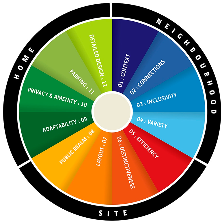
- For the first group, with three models out of thirteen, all four dimensions were adopted for evaluating and redeveloping streets. This group relied on the dimensions of the PPS, which became the basis for the research and practical assessments, as shown in Figure 1 and Appendix A Table A1 [7,9,10]
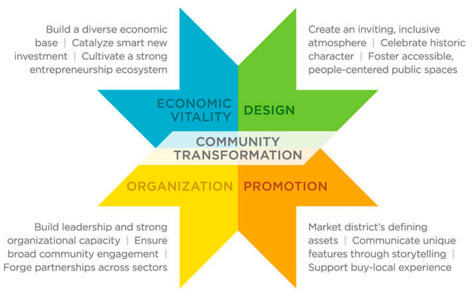
- The second group, with three models, shared the same basic dimensions. Other dimensions were added according to the context of the research sample, site analysis, and conservation, since the selected site was within a conservation area. Both climatic and economic variables were added to the consideration of the selected samples, as shown in Appendix A Table A2 [11,12,13].
- Three other models added commercial and economic dimensions to the primary model, either implicitly in one of the main dimensions or explicitly, as shown in Appendix A Table A3 [14,15,16].
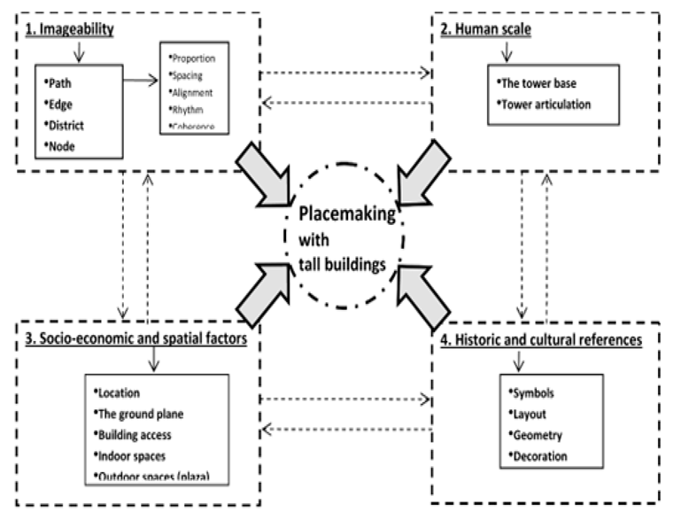
- Dimensions such as design, environment, urban context, history, space, human scale, climate, and sense of place were mentioned individually and according to the research need and problem in this group. Researchers have praised the importance of these dimensions as the basic pillars of placemaking that had not been considered previously, as shown in Appendix A Table A4 [17,18,19,20]. (Please see the compared dimensions table in Appendix A.)
- By comparing the dimensions of the aforementioned models presented by the researchers, an extrapolation was performed to determine the most important and consistent factors to use within the model and the framework, both theoretically and practically.
- The least frequently used dimensions in the previous studies were also included in the theoretical framework. A comprehensive evaluation of placemaking was extracted to evaluate the livability of a commercial street, as shown in Figure 2.
Figure 1.
The PPS placemaking model with four dimensions.
Figure 2.
Dimensional extrapolation. Source: Author.
2.1.2. Second Step (The Additional Dimension)
This section details the additional influential dimension included in the placemaking framework, which did not appear explicitly in previous models. However, it has been widely mentioned by many researchers who have praised its effectiveness in placemaking.
A Sense of Place
Ellery presented a model in which individuals were at the core, including all their sensory information assembled from a place, their perceptions based on their relationship with a place, and the connections created between the individual and the place. Regardless of the positivity or negativity of these perceptions, they form a certain association with a place. This is called a “sense of place” and has significant benefits, including improving social communication and strengthening the relationships between individuals. Ellery presented a placemaking model that depended on the connections between places and people. This was considered an essential part of placemaking mechanics [14]. The PPS has declared that space and place, as terms, are often used interchangeably and have different meanings depending on the setting. Placemaking theory suggested that place creation exceeded the physical dimension and involved other aspects, such as sociability, mixed uses, accessibility, interactions, and comfort. This produced bonds between people and places that then created a sense of place [7]. Cresswell regarded a sense of place as a way of knowing more about a place, as it was more cognitive than existential and involved the spatial connection that people have to a place. The availability of the spatial sufficiency associated with the needs of people and the appointed time generated a meaning of the place [21]. Lynch identified that the psychology of the place was connected to a mental map people used as a guide in urban places, using their senses to express whether the place was safe, comfortable, vital, or threatening [22]. Iris presented several theorists’ perspectives on a sense of place and how a sense of belonging was formed through buildings with historical character. Placemaking could be achieved on a variety of scales, from the balcony of a house to the city streets, where people gather [23]. Many aspects of placemaking rely on inviting people to suggest activities. By providing suggestions for the development of places, people become more familiar with needs and activities, which then generates a sense of place. To influence social structures, we sought a practical application to link the relationship between people and place, as the communication among people in a specific space could provide a sensory understanding of community participation. This has been associated with people understanding and accepting the spaces in which they are active [24]. Ralph described a sense of place as the possession and creation of place and developing a system of meaningful places that shape our experiences [25]. The creation of place is a result of the synthesis of spatial experiences, scenes, stories, feelings, and concepts. It has been intricately linked to history, cultural identity, and social relations as an essential component of an event [26]. Experience is one of the essential factors for a sense of place [27]. It involves psychological, cognitive, and emotional processes, as well as physical activities, and has been defined according to three parts: the identification and recognition of a place; the feelings about or the evaluation of a place; and the behaviors and interactions that occur in a place [28]. Depending on its description, a sense of place could be defined as an integral consideration for placemaking and necessary to ensure the strength of human attachments.
A Sense of Place and Placemaking
A sense of place typically develops from common relations, activities, information exchange, and interactions in a space, particularly in small spaces. Minor actions, such as siting, standing, and talking, develop a place’s character over time and are regarded as essential motivations for developing a person’s sense of place. Theoretical research has suggested that traditional environments provide a better sense of place and evoke deep-rooted cultural meanings. Placemaking stems from the dissatisfaction with designs that were not created based on an understanding of contemporary urban spaces [18]. Placemaking endorses a substantial sense of belonging and a sense of place. The changing public space is a result of the imagination and the interactions between people. Comfort, safety, and security needs have created unique identities for places [29]. Placemaking has gradually moved towards focusing on the cultural developments in urban spaces, as these have greatly impacted the creation of a sense of place that could evoke a city’s character [30]. Creating a sense of place has also been related to the number of activities and events that have transpired at that location. These activities provide opportunities for conversations and social gatherings, as was evident in the “Power of Ten”, which included the availability of numerous activities for people of all ages in a city. Certain strategies have been followed to attract a higher density of people to vital entertainment venues. Places often succeed when people have a range of entertainment choices (more than ten activities). These could include outdoor seating, playgrounds, art, music, access to food, history to experience, and people to meet. Furthermore, some of these activities could be unique to a locale, reflecting the culture of the surrounding community [31]. Another important component of placemaking is the availability of retail establishments, as these offer a wide variety of choices within the urban space. Retail establishments have economic, social, and local dimensions, in addition to their likelihood to attract more people to a specific place [30]. Another important element in a city that constitutes an essential part of its structure is its streets, which include many activities and functions that could provide a sense of place. Therefore, all physical features of a street, such as the buildings and their elements as well as the landscape design, significantly contribute to making a street a safe and comfortable environment for people [27]. These aforementioned considerations generate a question: Why is a sense of place a necessary component in placemaking? A sense of place is linked with three main components: a strong connection with the history and information of a place; an applied practical reference formed through place attachment and place identity; and finally, its psychological effect on visitors. Accordingly, it was related to the three components of placemaking that were proposed previously, namely sociability, image, and activities. At this stage, an initial model was formed as a base for modifying the framework, as shown in Figure 3 and Figure 4.
Figure 3.
Placemaking dimension. Adapted with permission from Reference: [7].
Figure 4.
The initial dimensions of placemaking. Source: author.
2.1.3. Third Step (The Theoretical Dimensions)
The final step was defining the model for the placemaking framework. Several theories on place and placemaking were reviewed for the identification of the dimensions and main factors related to generating lively places. Despite the significant disparity in theorists’ attitudes towards place theory, most have pointed to the importance of the physical setting, its image, activities, and diversity as critical for activating a space, as well as the connection between people and places. These dimensions are regarded as the basis of placemaking theory, conveying many benefits to both the environment and society. Jacob noted the importance of streets as social spaces, instead of being only for transportation, and he was the first to explore place quality as defined by the activities that increase the value attributed to a built environment [8].
“Streets should be for staying in, and not just for moving through, the way they are today”, posited Christopher Alexander, a theorist who presented concepts and theories that impact the design of cities and streets and all their details. These concepts include wholeness, which adopts the concept of integrating a space with the vital needs of people in order to improve its usability. In the paper New Concepts in Complexity Theory, Alexander interpreted wholeness as the basis for spatial configurations and a key to many events and phenomena that represent aspects of system behavior. In A Pattern Language, the authors pointed to the importance of adopting people’s concepts when designing a city and its streets. This concept revived the livability aspect, since people’s needs are simple within a public space that can adapt to these needs, as the essence of creating beautiful places [32,33]. Most of the beautiful places in the world have not been designed by architects but by the inhabitants themselves [7]. Alexander et al. also discussed the process of locating any shop on the street, which involved several basic aspects, including the having the need for it, filling a functional void, and the existence of activities [32]. Three basic concepts that are the essence of placemaking have been advanced by Alexander et al.: wholeness, the consideration of people’s concepts and needs when designing, and addressing the smallest details related to their daily needs.
Gehl argued that successful urban places were predominantly reliant on street life and the different ways that activities were distributed and occurred on a street [34]. An aspect of placemaking is the conversion of a space into a place, which occurs when someone develops emotions associated with that location, which then makes it meaningful for them, as Cresswell explained. In addition, place memory and spatial recognition impact place theories, as well, and for Cresswell, location, locality, and a sense of place were the main components [21]. In turn, Gehl drew architects’ and planners’ attention to the importance of the spaces between buildings and their impact on creating a livable environment by connecting physical settings and activities on a street [35]. Punter suggested a model for enhancing a sense of place, and this was further discussed by Montgomery, who regarded a sense of place as an essential factor in placemaking due to how human experiences affect spatial correlations. Punter reinterpreted the models presented by both Relph in 1976 and Canter in 1977. The model demonstrated connecting activities, physical settings, and the methods for enhancing the use of places, as shown in Figure 5 [36].
Figure 5.
Component of sense of place. Source: [36].
Canter introduced an identification process for a place, and this theory had three pillars, including activities, physical attributes, and conceptions [37,38]. Canter’s theory had a practical dimension, in addition to the theoretical, as it included the core of design decisions. As a foundation of place theory, Canter explained the importance of integrating two realms: the various design aspects presented by designers; and the results gathered from the environment and through behavioral research. Accordingly, a framework was created based on the integration of place experiences, including social, individual, and cultural aspects. However, different behavioral and environmental research models have operated as independent theories alongside place theories. Hypothetically, these aspects assumed the importance of analyzing place studies according to building perceptions in order to reveal similar components of spatial experiences. The theory integrated personal, social, and cultural elements and used the place as a neutral term in the physical and social experience of a place, as shown in Figure 6 [39]. Montgomery suggested that two models for discussion were the result of a person’s perception, concept, and cognition, as well as the physical attributes of a place. In addition, Montgomery also discussed the components of place according to Punter, focusing on the importance of a sense of place in activating placemaking and how the concepts and meaning derived from human experiences with a place affect the spatial association. Montgomery stressed these three principles as highlighting the quality of a good location [36] and believed that these principles greatly impacted the characteristics of placemaking and creating successful urban places. Instead of relying only on the physical space, the main axis was a sense of place, and all the activities, physical settings, and meanings were acquired accordingly. Montgomery combined the two models, both Punter and Canter’s, to form the basis of placemaking in order to best determine the qualitative specifications, as shown in Figure 7.
Figure 6.
Canter model, place components. Source: [37,39].
Figure 7.
The Updated Place Component by Montgomery Source: [36].
Mojgan reviewed previous models and presented a model that enhanced the quality of a place and demonstrated how design contributes to a sense of place. By considering the importance of these components, this theory was easy to adapt for placemaking principles, as shown in Figure 8 [38]. “To be is to be in a place”, according to Seamon, who suggested that a person was essentially integrated, and any understanding of their life could be truly related to the quality of a place [40]. Seamon also introduced other components for place theory: the environment and the geographical location; the people living there; and the togetherness of a place. Then, Seamon combined these elements into a three-arrow model [41], which regarded a place as a phenomenon connecting humans and their activities as part of a complete image of a place. Since place had been originally defined by its close connection to human activities, Seamon identified six interconnected place components to present a complete image of a place, as shown in Figure 9. Figure 10 shows our research steps for extracting dimensions and adopting a new framework.
Figure 8.
Components of sense of place. Source: [38] (p. 5), [36] (p. 85).
Figure 9.
Seamon place components [40,41] (p. 7).
Figure 10.
The research steps for extracting dimensions and adopting the new framework [7,11,14,18,21,22,23,24,25,26,27,28,30,36,37,38]. Source: Author.
2.2. Placemaking Model
According to our literature review of place theory, we followed the following methodology:
- Dimensions were compared to identify the most influential studies in place and placemaking.
- After reviewing the models and according to previous studies that developed or applied these models, we identified the importance of the four dimensions: sociability; access and linkages; uses and activities; and comfort and image [7,9,10,11,12,13,14,15,16,17,18,19,20]. Punter, Canter, Montgomery, Mojgan, and Seamon [36,38,39,40,41] all agreed on the presence of three main dimensions that had could improve the quality of a place: the social aspect, the physical setting, and the meaning or sense of place. After comparing these practical and theoretical aspects, our model was restructured to reflect a local commercial street.
- According to the previous literature, the theoretical framework was reconfigured into a practical framework, consisting of three pillars. Consequently, the organization of these three dimensions was reduced and restructured, as shown in Table 1.
- Our research identified three main dimensions: physical setting, sociability, and image. Each dimension was then subdivided into another secondary dimension, including factors, secondary factors, and possible values, as shown in Figure 11.
- Our research adopted these dimensions and factors as the foundation of the practical framework. The placemaking framework was identified as appropriate for assessing placemaking strategies for commercial streets.
- The practical framework consisted of five sequences, starting with dimensions, sub-dimensions, factors, sub-factors, and possible values, which had detailed descriptions for every factor to identify the best and worst phenomena of the street, and an example is shown in Table 2. For more details, the comprehensive practical framework is available in Appendix B.
Table 1.
Theoretical framework with dimensions, factors, and possible values. Source: Author.
Figure 11.
The placemaking model (theoretical framework). Source: Author.
Table 2.
Placemaking framework (practical framework). Example for the suggested framework. Source: Author.
2.2.1. Sociability Dimension
Streets without people and everyday life have little atmosphere. The social dimension identified people’s responses to a street based on the density of people generated by the street design [42]. This dimension concerned the social life of a street, as places are not only physical features and spaces but also have social aspects as well [43]. Carmona suggested that understanding the relationship between people and places was an essential element in urban design [44]. Placemaking is essentially a human experience. The principle of inspiration is to reinvent a physical and social environment that can be shared. The ways people gather to form a safe, comfortable, and social environment are a result of a purposeful, systematic design that also enhances the place’s features [12]. Outdoor locations facilitate many social activities and events, usually as a result of planning and place design that considers comfort and safety. Correspondingly, feelings and attachments to a place can form and allow the social activity itself to be a catalyst for relationships and as a link to the senses [35]. Places that contribute to forming a community and nurturing the relationships between its members provide continuity from the past to the present, meet many daily needs, and contribute to defining the community’s identity. Such a place has a positive influence on daily life and encourages interaction [45]. Diversity is one of the important concepts related to urban vitality, including the primary uses and activities required by people in their daily lives. A combination of activities is the key to generating diversity and population density and creating successful urban spaces for social interactions [38].
The social dimension included a group of factors that defined people’s expected interactions as a result of creating interactions in the street. This dimension included density, diversity, functionality, visibility, seating, maintenance, economic satisfaction, and adaptability. These factors were interrelated to describe the spatial interaction among people.
2.2.2. Physical Setting Dimension
Lynch believed that any physical form has an impact on people’s activities, and a city has both physical characteristics and social units. A city has a size, a plan, and a pattern that are vital features of its physical form. The people who live in a city both shape and are shaped by these features, and the perceived value of these features is based on people’s perceptions [22]. A place is defined by a mental image, behaviors, and the physical setting. A model with a mental image has an implicit temporal dimension in which experience is reflected by one’s affective and cognitive responses to their current physical settings, and this image is connected to their physical settings and related activities [46]. It would be inaccurate to separate the social and physical aspects, such as the physical features, including landscape design, sidewalks, seating, etc., that enrich a place’s characteristics and provide comfort for users, encouraging use, diversity, and social relationships [47]. Improvements in street livability have a close connection with the physical elements, planning, and architectural design of sidewalks, streets, and buildings. These also determine local transportation routes and separate motorists from pedestrians, whereas seating and decorations play a vital role in creating a spatial presence [43]. Physical characteristics are the dominant factors that can influence a person’s sense of place [48]. They affect many factors and increase the function of other visual dimensions, along with the sense of place and the social aspects as well. Walkability, for example, is greatly affected by physical features and had a meaningful relationship with the conditions of a built environment [49]. Providing visual interest and encouraging people to walk is a fundamental element of placemaking. Accordingly, the edges of streets must include walkways to guide people, enhance functionality, ensure continuity, and encourage diverse activities [4]. The characteristics of outdoor activities are affected by design and physical settings. Adding a specific color, material, or a certain type of plant as well as exposing sidewalks and providing seating areas can create patterns of activities and generate a positive atmosphere [46]. The physical dimension is divided into three secondary sub-dimensions with factors of a place’s performance. Physical components positively affect the provision of suitable architectural forms on a commercial street and result in attractive street design. This dimension included the following factors: human scale, edge compatibility, morphology, building direction, building length, inclusiveness, connectivity, uniformity, physical characteristics, enclosures, architectural styles, urban context, simplicity, proximity to transit, clarity, movement patterns, continuity, spatial layout (patterns), spatial configuration, availability, climate protection, and greenery.
2.2.3. Familiarity Dimension
Lynch and Relph pointed to the importance of images, place experience, and the physical setting in a place’s identity. Mental images strengthen the bonds between people and places. Lynch presented five elements for creating a mental map to assist with wayfinding. Familiarity and simplicity are essential factors in placemaking, according to Lynch’s approach, which defined familiarity as the quality of a physical feature that provides an individual with a strong, intense image of the paths, network, and potential ways through an urban environment [22,25]. Seamon emphasized the importance of phenomenology in placemaking: the place is the phenomenon that connects humans with their activities. This presented a whole image of place phenomenology in placemaking [40]. Most current design guidelines use constant, communal, generic terms to describe urban design and placemaking requirements. Following these guidelines leads to reliable and consistent placemaking, and they have been regarded as essential for perceptual qualities, such as familiarity and visual enclosure [48]. Familiarity is the quality of a space that distinguishes it from others and makes it recognizable and memorable. It is associated with specific physical elements that can create a unique place. Familiarity is the result of other urban design characteristics, such as human scale, permeability, connectivity, and enclosure. When a spatial structure is understandable with a coherent pattern, it is then considered memorable [38]. Community image and identity have often been formed through a shared history, and placemaking has sought to create unique and vital destinations by highlighting historical events and points of interest [24]. Lynch’s theory of imageability assisted in creating places according to the built environment to make urban locations more distinct and navigable [50]. As a result, our research identified a group of factors within familiarity that were highly influential. The factors were the following: memory (attractiveness, locality, identity, place attachment), safety (separation, speed), comfort (physical comfort and social comfort), and qualified street (unified sense of place, social bonding, and sense of belonging), as shown in Figure 12.
Figure 12.
The three main dimensions.
2.3. Placemaking Framework
Our research employed an extensive study of theoretical references related to the concept of place theory and placemaking. A comprehensive knowledge base was the foundation for defining placemaking strategies, with steps, accurate descriptions, and clear associations with the dimensions previously identified.
Each dimension included factors associated with its relationships with the other dimensions in the model. This framework included a group of possible values that explain the design, sociability, familiarity, and physical aspects. The result of each set of indicators was associated with one of the factors, and the latter was linked to one of the three dimensions. For the framework to provide accurate assessments, a three-point Likert scale was adopted to describe each possible value. Through the application of the list, the placemaking activating steps were evaluated, and it was assumed that the more placemaking steps were applied, the higher the livability of the commercial street.
2.4. Study Method
Selecting the Street
Selecting the research sample was initially determined after a systematic approach according to the examples in previous studies as well as the city context and streets.
- The first stage was to identify several commercial streets as candidates.
- We decided to select connector streets between the circular throughways of Erbil city, as these were categorized as crowded and diverse commercial streets.
- The widths of the selected streets were 20–50 m, and the lengths were 600–2000 m.
- A rapid pilot survey was conducted to obtain local opinions on the most lively and livable streets, as shown in Figure 13. Of the seven commercial streets, Eskan Street had the highest rate of preference (35%) and was selected as the research object.
- People identified this street as being multi-functional and diverse, with attraction points, in addition to having two parking areas, as shown in Figure 14.
- Eskan Street was adopted as the research object for the application of our placemaking framework to assess its livability.
Table 3.
Selection list (criteria for selecting case study). Source: Author.
Table 4.
The sequence of selecting the case study.
Figure 13.
Comparing the streets.
Figure 14.
Reasons for selecting Eskan Street.
2.5. Case Study
Erbil Governorate is located in the northern part of Iraq, in the Kurdistan Region. It is characterized by dry semi-continental weather, with hot and dry summers as well as cold and wet winters. Erbil is regarded as the commercial and administrative center of the region and one of the oldest continuously inhabited cities in the world [51]. Eskan is a neighborhood in Erbil city about 14 min from the city center. One of the famous and essential streets in Erbil city passes through the neighborhood of Eskan. Eskan Street is located south of the historic Erbil citadel, about 1 kilometer away. It is considered one of the most popular and lively streets in the neighborhood in one of the most important commercial areas. It includes the first market in Erbil city, along with many restaurants, cafes, shops, gardens, and street vendors. It includes a wide range of recreational facilities which define it as an essential and integrated area [52].
2.6. Street Description
- Eskan Street is frequented by many Erbil residents, as well as tourists. The street connects two vital streets in Erbil city, the 30th Street and 60th Street, as shown in Figure 15.
- Eskan Street is distinguished by its many activities and a variety of restaurants and cafes, most of which serve local dishes.
- It also includes other amenities, such as hotels and motels, markets, mobile shops, car shops, and clothes shops, in addition to tailoring and barber shops. At the end of the street, towards the city center via 30th Street, there is a large shopping center with many shops and various activities, as shown in Figure 16.
- The street includes several cafes, which attract many young people.
- It contains a large garden that occupies the left side of the street, with a cafeteria with an area of approximately 6592 m2.
- The length of the street is approximately 670 m, with an area of 12,226 square meters and a width of 20 m.
- The street contains many carts and booths selling local foods and juices that vary according to the seasons of the year. For further information regarded Eskan Street see the Supplementary Materials.
Figure 15.
The main land uses on Eskan Street.
Figure 16.
Important activities on Eskan Street.
2.7. Methods
The methods adopted by the research include the practical framework and a questionnaire given to architects and urban designers. We identified the positive and negative aspects through observation and survey data.
2.7.1. Field Survey
- We used several methods of data collection, including a field survey, which was divided into three aspects: the physical setting (urban, design, architectural details, features/seating, vegetation, diverse activities, and factors related to both streets and sidewalks), sociability, and familiarity.
- The field survey included three time periods: 9:00 a.m., 1:00 p.m., and 9:00 p.m. Information was entered into the survey table to determine the diversity, social differences, and population density, according to the time periods.
- The field survey was carried out over two seasons (summer and winter).
- In summer, the survey was performed from 15 June to 15 July, three times per day, from 9:00 a.m. to 1:00 p.m., from 2:00 p.m. to 5 p.m., and from 9:00 p.m. to midnight.
- For the period of 9:00 a.m.–1:00 p.m., most of the activities occurred in supermarkets and mobile and construction shops. The busiest locations were restaurants and cafes that served breakfast to people going to work, since the street is close to the city center, where most businesses are located. After this time, the population density gradually decreased for an hour.
- Density and overcrowding increased again for the period of 12:00 p.m.–2:00 p.m. as this was typically lunchtime.
- The street vendors offered local and popular dishes and their prices were affordable, which, in addition to the close proximity to Erbil city center, were likely contributors to the increase in density.
- In the summer, for the period of 2:00 p.m.–6:00 p.m., the foot traffic decreased due to the intense heat, but the density gradually returned by 6:30 p.m.–12:00 a.m. On holidays (Friday and Saturday), the street was active until 2:00 am.
- The survey times included these specific periods to determine the population density and the most popular activities.
- Some construction shops and mobile services closed at 6:00 p.m.; however, sweet shops, markets, restaurants, and cafes were open.
- In the summer, the garden operated from 6:00 p.m. to 12:00 a.m., as it was rarely used during the day due to the heat.
- The survey was repeated to identify the most important changes in activities in the winter.
- In the winter, the survey was performed from 15 December to 15 January and included three time periods: 9:00 a.m., 1:00 p.m., and 4:00 p.m.
- Juice shops switched to serving tea, coffee, and traditional sweets.
- The use of the garden changed from nighttime hours (after 6:00 pm) to daytime hours (12:00 p.m.–5:00 pm/sunset).
- In the winter, activities did not continue until midnight, instead ending around 8:00 p.m. or 9:00 p.m.
- In general, the street was more active for a longer time period in the summer, and movement usually increased in the summer after 6:00 p.m. due to the extremely hot weather during the day.
- However, after 6:00 p.m. in the winter, the movement of people decreased, and we noticed that some shop owners installed temporary nylon structures outside with a wood or gas fireplace to create a comfortable atmosphere for users.
2.7.2. Observation
Observations were conducted to identify the following points:
- The movement of people and the population density were monitored by activity.
- The most frequently used activities, as well as the age and gender of those on the street, were recorded.
- Formal and informal activities, including eating and drinking dishes from booths and carts selling affordable local food, were observed.
- Pedestrian movement, ease of walking, accessibility, sidewalk width, suitability for movement, and the number of people using the sidewalks were recorded.
- Street crosswalks and the appropriate physical features and elements to facilitate crossings were observed.
- Amenities and seating as well as their availability within the street space and near sidewalks were recorded.
3. Results and Discussion
3.1. Field and Observation Results
Several positive and negative points were identified. Capitalizing on the positive points could raise the performance and increase the use of the street. The negative points could represent solutions that need to be developed to improve the street’s vitality, livability, and sociability. The results were reviewed according to the research dimensions.
3.1.1. Activities and Land Use of Street (Sociability)
Figure 17.
Street activities by type.
Figure 18.
Activities by percentage.
- The activities concerned mostly restaurants and cafes, and the food served varied greatly between local and fast food, attracting many people, predominantly males.
- The street had many other shops that were relevant for daily needs.
- A large shopping center on 30th Street had many shops and services that were frequented by people from all over the city, as shown in Figure 19.
- The numerous restaurants and cafes had a significant impact on attracting people, especially young people. During important events, such as the World Cup, which was held in December 2022, the street was closed to provide a suitable environment for people to move safely and to exploit the street space since the sidewalks could not otherwise handle a large number of people, as shown in Figure 20.
- A main attraction was the food and juice carts and booths, with a variety of meals that change based on the season, from juices and cold drinks in the summer to hot local foods and drinks in the the winter, such as tea, baklava, hummus, broad beans, and turnips. Many people bought takeaways or gathered to eat with friends as a social gathering, and the feeling of vitality was very evident, as shown in Figure 21 and Figure 22.
Figure 19.
The shopping center.
Figure 20.
Restaurants and cafes.
Figure 21.
Local food.
Figure 22.
Food booths.
- The street was crowded all day, except in the early morning hours. At night, the traffic was the highest, and the speeds of motor vehicles did not exceed 30 km per hour. This provided some protection for pedestrians when crossing the street.
- The negative effects included activities that interrupted the continuity of walkability, such as shops closing early (4 p.m.) and empty sites.
- However, a positive influence was that Eskan Street was nearly devoid of houses and empty lots. This promoted the continuity of commercial facades and strengthened the spatial connection, as shown in Figure 23. Residential housing results in intermittent commercial facades, which affects the social continuity and walkability.
Figure 23.
Houses and empty sites compared with restaurants and cafes on the street, by percentage.
- Building plinths did not prohibit diverse activities and had excellent lighting at night, with a suitable pedestrian area that could accommodate up to four people, as shown in Figure 24. Plinths are a very important part of buildings, the ground floor, and the city at eye level. A building could be unpleasant, but with a lively plinth, one’s experience of it could be positive. The inverse was true, as well, as even if the building was attractive, but the ground floor was plain, the experience at the street level would not be positive [5].
- Most of the visitors to the street were males, with approximately fifty males walking or shopping on the street, as compared to approximately two women. This was one of the negative aspects of the commercial street.
Figure 24.
The continuous plinths (elevations at the ground level).
3.1.2. Physical Setting
- The street sidewalks were distinguished by several positive points that encouraged walking, including a width of approximately 5 m that could accommodate up to four people, and in some parts, such as in front of the shopping center, it reached 10 m in width.
- Good tiling with unified materials and few interruptions on the same level as well as continuous sidewalks improved the walkability.
- The minimum width of the sidewalk for commercial streets in the central area was 4.8 m [53].
- The sidewalk design included three design components: the frontage zone, pedestrian zone, and fixture zone; see Figure 25.
- The height of the raised sidewalks was appropriate to prevent cars from driving on the sidewalks or cutting off pedestrian traffic.
- Despite the lack of canopies to protect pedestrians, most of the buildings were set back from the street, offering shade for pedestrians, as shown in Figure 26.
- The percentage of vegetation cover was limited, as were the number of trees, except for the afforestation on the right side of the street due to the garden that covered approximately 6592 m2 and provided a café and sitting area, as shown in Figure 27.
Figure 25.
Three parts available on street sidewalks.
Figure 26.
Pedestrian protection slab.
Figure 27.
Garden and green cover percentage of the street.
- There were few trees nearby, and most were not maintained. The approximate number of trees on the whole street was only 40, as shown in Figure 28. The garden was occupied by many trees, however, as shown in Figure 29. As trees protect pedestrians from the sun, ease the weather, and are aesthetic and attractive additions to a commercial street, they should be further considered here.
Figure 28.
Limited number of trees on street.
Figure 29.
Most trees were in the garden.
- The general lines of the building facades and within the perspective of the street were somewhat proportional and uniform in height. Most buildings were two stories tall, except for a few buildings that exceeded three stories, and one of the buildings was eight stories tall. See Figure 30.
Figure 30.
Building heights on the street; most were only two stories tall.
3.1.3. Familiarity
- The street was defined by its attractions and well-known buildings, which served to distinguish Eskan Street from the streets surrounding it. Ideally, streets should be defined by buildings of different heights or functions, or even by an architectural style. Two buildings were well known on Eskan Street in general, and both were located on the 30th street, as shown in Figure 31.
Figure 31.
Important buildings on the street.
- Short poles served to demarcate the sidewalk from the street and eliminate car overtaking in some areas. These columns significantly promoted pedestrian safety.
- Within the fixture zones, there were electricity poles, trees, billboards, and trash bins. These elements defined the edge, preventing cars from overtaking, and formed a clear visual axis for the street and the sidewalks on both sides, as shown in Figure 32.
Figure 32.
Sidewalk fixtures.
- Although sidewalks were suitable for the movement of people, shop owners used them to display their goods, sell food and juices, or offer seating for their diners.
- Some buildings and restaurants took advantage of the frontage zone to add structural elements, such as raised platforms and a few steps for entry. These elements were considered an obstacle to the movement of people, and in some places, pedestrians were forced to move onto the street to continue walking, exposing them to vehicular traffic, as shown in Figure 33.
Figure 33.
Overtaking on sidewalks by shop owners.
- A simultaneously positive and negative point was the availability of seating on the sidewalks, but these were the private property of restaurants and cafe owners. Therefore, only people who wanted to eat in these restaurants could use them. The street was devoid of public seating. Fixtures and their placement on the sidewalks and the street promoted the comfort and safety of pedestrians, as shown in Figure 34.
Figure 34.
Seating on sidewalks.
- Although the trees were limited, they provided shade and enriched the visual aesthetic on this part of the street; the contrast was obvious, as shown in Figure 35.
Figure 35.
Trees on sidewalks (very limited).
- One of the pedestrian attractions on the commercial street was the large shop windows. However, most shops on Eskan Street were restaurants and cafes, and many restaurants relied on using the sidewalk areas for seating. In addition, shop owners used the sidewalks to display their goods. These two issues eliminated much of the opportunity for “window shopping”.
- For shops with large, visible windows in the front, a visual connection was possible between the pedestrians and the shops. At night, this sensory connection and visual transparency was heightened due to the increased lighting, as shown in Figure 36.
Figure 36.
Façade transparency of shops.
- The sidewalks showed a clear visual connection via uniform tiling materials and limited obstacles within the pedestrian zone. This visual connection had an impact on many levels, including providing a unified character for the sidewalks, encouraging walking, promoting comfort while moving, and presenting a beautiful street image, as shown in Figure 37.
Figure 37.
Sidewalk continuity.
- Some uses of street fixtures and tree planter boxes positively attracted passersby to stop and relax or enjoy time with friends. This created an interactive atmosphere, especially since the space in front of the shopping center was spacious and could facilitate many activities, as shown in Figure 38.
Figure 38.
Fixtures created an attractive point for people to gather.
- One of the points that negatively affected the aesthetic image of the street was the poor cleaning and maintenance of the street, its fixtures, and its lighting. Cleanliness is a very important factor for attracting people. In general, though, there was little interest in cleanliness, as shown in Figure 39.
Figure 39.
Sidewalk maintenance.
- The street did not include standardized architectural styles and elements, and most designs were unique and did not follow general frameworks. One of the positive aspects of this was that some restaurant owners used traditional materials, such as bricks, to add a local character to their facades, as shown in Figure 40.
Figure 40.
Architectural styles and elements on the street.
3.2. Practical Framework and Questionnaire Results
A questionnaire was given to architects and urban designers to determine the important placemaking strategies for achieving livability. The purpose was to identify the local dimensions of Erbil city and its commercial streets by evaluating the livability of Eskan Street. The results of the framework and the questionnaire were analyzed using the SPSS statistical program, and the results are described in the following sections.
3.2.1. Practical Framework Results
Our research used the framework to identify the most accurate steps and strategies for placemaking. Commercial streets included many activities typically associated with city streets to meet people’s needs. The main dimensions were broken down into secondary aspects, and then into factors and sub-factors. By using the possible values linked with each factor, we assessed Eskan Street according to this placemaking strategy. The data were analyzed to identify the outcomes of the framework.
Sociability Results
The social dimension included three factors, along with secondary factors. The first factor was social design and activities, which included the secondary factors of density, diversity, and functionality, with a result of 2.50. The second factor was the quality of the street, including the visibility, fixture availability and maintenance, and satisfaction, which had a lower rate of 2.25. The highest rate was associated with the economic factor, which included economic satisfaction and adaptability with a ratio of 2.60.
Therefore, the economic factor was the most influential in this group, followed by social design and activities, while the quality of the street was the least significant, as shown in Figure 41.
Figure 41.
Sociability dimensions.
From the results of the secondary factors, it appeared that functionality was the most important in terms of functional diversity and ease of movements between various activities. Adaptability ranked second, which concerned the ability of the street to adapt to people’s needs, whether by changing the seating arrangements or, in particular, by changing the type of formal and informal services, as shown in Figure 42.
Figure 42.
Sociability sub-factors.
Physical Setting Results
The physical setting concerned several secondary dimensions, namely the architectural design, access and linkages, and environment. The sub-dimension included the building and street design, architectural design, accessibility, walkability, spatial characteristics, and climate comfort, which were associated with several factors and secondary factors: human scale, edge compatibility, morphology, building direction, building length, inclusiveness, connectivity, uniformity, physical characteristics, enclosures, architectural style, urban context, simplicity, proximity to transit, clarity, movement patterns, continuity, spatial layout (patterns), spatial configuration, availability, climate protection, and greenery. Figure 43 shows that the most influential factors in the group were walkability, with a rate of 3.00, and street design and spatial characteristics, each with a rate of 2.62. The most influential secondary factors were inclusiveness, in terms of ease of movement, use of the street, and accessibility. Uniformity was the most appreciated, as the unification of the height and the coordination of the width of the sidewalks and their continuity were among the specifications that appeared clearly in the street space. The same applied to simplicity, the connectivity of blocks, buildings facades, the continuity of the sidewalks, and the diversity of uses.
Figure 43.
Physical setting results.
As for the secondary factors, the highest of the group included inclusiveness, uniformity, simplicity, movement patterns, and continuity, each with a rate of 3.00. In order of importance, connectivity, spatial layout, and the spatial temporal factors were ranked second at a rate of 2.75. The factor with the lowest percentage was the architectural style (1.00). People seek comfort, safety, diversity, and local food when traversing commercial streets, as compared to their concerns over building appeal. Engaging activities were more valued than other aspects, as shown in Figure 44.
Figure 44.
Results for physical setting sub-factors.
Familiarity Results
The familiarity dimension included two secondary dimensions, which were Imageability and a sense of place. The main factors included memory, safety, comfort, and having a qualified street. The secondary factors were attractiveness, locality, identity, place attachment, separation, speed, physical comfort, social comfort, unified sense of place, social bonding, and a sense of belonging. As shown in Figure 45, the qualified street was the highest in the group, which included holding a cultural event in the street, the attractiveness of the atmosphere, and entertainment. Safety ranked second, as many points increased the quality of the place, and it consisted of the limited street width not exceeding 20 m and the consistency between the width and height of the street and the buildings.
Figure 45.
Results for familiarity dimensions.
The consistency and proportionality between the street width and building heights slowed motorist traffic, which, in turn, promoted pedestrian safety and increased their comfort [32].
After comparing the secondary factors, we noted that three factors from the group dominated the rest: place attachment, a unified sense of place, and a sense of belonging, with a ratio of 2.67. Ranking second were separation, speed, and social comfort, with a rate of 2.50. The other secondary factors varied between 2.40 and 2.33, as shown in Figure 46. The importance of these secondary factors related to the human connection to the street and the desire to walk and take advantage the various desired activities. In addition, the street held many cultural events, which offered increased social diversity and inspired commitment to the space.
Figure 46.
Results for familiarity sub-factors.
3.2.2. Questionnaire Results
The questionnaire was based on the following aspects:
- The questionnaire was directed to architects and urban designers, as the research aimed to determine systematic strategies and detailed steps for placemaking.
- A total of 100 surveys were distributed to architects. Only 62 were received, and 7 of those contained inconsistent answers (the researchers added six pairs of verification questions; if the answers were different for more than six pairs, the questionnaire was canceled).
- The questionnaire consisted of two parts. The first presented a group of general questions concerning age and architectural specialization, as well as the respondent’s opinion on a comparison of seven commercial streets.
- The second part included two main aspects of the research: placemaking (which included questions regarding the three pillars of physical setting, sociability, and familiarity) and questions related to livability. Appendix C shows the questionnaire’s contents.
- The questionnaire was created similarly to the practical framework and according to the same approach, and it was built to conform to the dimensions and factors that were used in the field survey.
- This allowed us to easily compare the approaches. By comparing the averages of the results of the questionnaire regarding the main and secondary dimensions and factors, the most influential dimensions were comfort and safety, along with the economic factor, accessibility, and walkability. In Figure 47, the physical dimensions of the street, including sidewalk width, the availability of fixtures, activities, diversity, and beautiful Imageability, were among the most influential. These were regarded as the most important for activating livability.
- Land use diversity, the variety of restaurants, and plentiful cafes were the top reasons for choosing this commercial street, in addition to being a comfortable street, as motorist traffic is limited. It also has a shopping center with many activities, services, and various shops, as well as entertainment for children.
- Female participants expressed their desire to walk on the street, though not at all times, as Eskan Street is considered a male-dominated street due to the quality of the food in restaurants and cafes and the gathering of young people to watch soccer. However, there have not been any objections to female pedestrians using it.
- Therefore, this should be considered when developing the street’s features, as most females expressed interest in its offerings. Moreover, many females visit the shopping center, even outnumbering male shoppers, though they typically visit during different time periods.
Figure 47.
Averaged sub-dimension results of the questionnaire.
The comparison between the two methods was conducted at two levels:
- The first was to compare the secondary dimensions to identify the differences between the two and the importance according to different points of view.
- The second concerned the three main dimensions.
- In general, the two methods showed consistency and convergence in their results, as shown in Table 5.
- By comparing the averages, and despite the close consistency between the results, it was clear that the physical aspects ranked the highest in both methods, with 3.99 and 4.07 for the questionnaire and the practical framework, respectively, followed by the familiarity aspect with 3.97 and 3.85, respectively.
- The last dimension in the ranking was sociability with 3.81 and 3.50, respectively.
Table 5.
Comparing the mean average of both the questionnaire and the practical framework.
Figure 48.
The main dimensions for the questionnaire.
Figure 49.
The main dimensions of the questionnaire.
As a comparison between the averages of both methods, we noted that the results were consistent regarding the secondary dimensions and factors, indicating their importance in placemaking. By comparing the secondary dimensions of the questionnaire and the practical framework, a consistency was found between the dimensions using both methods. The questionnaire results concerning the environment, accessibility, walkability, safety, comfort, and economic aspects were the highest ranking in the group. As for the practical framework, building design, walkability, environment, and economics were the highest rated. In comparison, both methods identified the importance of economic aspects, walkability, and the environment as the basic aspects of placemaking strategies which have a significant impact on street livability.
Safety and comfort, along with a sense of place, were also important dimensions that ranked second in terms of importance, though not by a considerable margin. Both methods recognized their importance in supporting livability, as shown in Figure 50. In general, each dimension, regardless of its rating, had a significant impact on the performance of the placemaking strategies; therefore, the more accurate the application, the more visible the symbiosis.
Figure 50.
Comparison of sub-dimensions.
The practical framework was evaluated according to three points (i.e., excellent, fair, and poor) for its application of placemaking strategies for Eskan Street. By comparing the results, we noticed that the percentage of strategies applied to the street was significant at 58.6%. The average percentage with a fair rating was 27.8% and with a poor rating was 13.5%. This indicated that the street included some specifications that were in line with the requirements for placemaking in terms of the inclusiveness of the steps. The street had many details, design features, and spatial dimensions that were commensurate with the human scale, all of which encouraged people to use and return to the street frequently, as shown in Figure 51. Figure 52 shows the methods and results.
Figure 51.
Placemaking strategies’ applied percentages for Eskan Street.
Figure 52.
Methods adopted and results.
3.3. Discussion and Conclusions
The process of placemaking must be conducted by municipalities, architects, and urban designers in cooperation with residents and locals. It is an inclusive and participatory process, and each dimension or factor, whether main or secondary, has an impact on activating placemaking strategies. By comparing the averages of the dimensions, we noted that three dimensions were essential for livability.
The most important dimension in the group was the physical setting. Its secondary dimensions with the highest ratios were street design, architectural design, accessibility, walkability, spatial characteristics, and environment. The familiarity dimension had higher secondary dimensions for safety and comfort. People emphasized the importance of street safety and preventing cars from mounting the sidewalks, as well as the importance of the ease of crossing the street and comfort when using the street. The last dimension was sociability.
This research presented a theoretical study using several literary references that addressed the concept of livability through placemaking strategies. An expanded comprehensive list was extracted to evaluate commercial streets in terms of their level of placemaking applications, using the most accurate factors with a direct impact on each step. According to the framework, it was possible to determine the limitations of the commercial street and which placemaking steps were weak or unavailable; this information could be used to direct improvements.
By comparing the applied models and theoretical perspectives regarding placemaking, we found that a place is a phenomenon of a space. The main dimensions of a place were clear and defined by both perspectives, as many contributions and studies have suggested frameworks for the development of place. Few studies were directed towards the development of the commercial street into a livable place, not just a shopping district. Several researchers have discussed individual and specific aspects of livability without specifying the details of its assessment through possible values. Others have not viewed placemaking strategies as essential steps to structure livability. However, previous studies built upon theoretical and practical frameworks that led to the formation of the three main dimensions used in this research. Furthermore, the intellectual and evaluative depth of this foundation was in the secondary dimensions and factors that were reconfigured within the practical framework to form a comprehensive checklist. This was one of the first studies to assess all the design details of a commercial street and the percentage of its application of placemaking strategies. Therefore, this study has filled a gap in the literature for assessing and developing commercial streets as livable places.
The practical framework was applied to one of the vital commercial streets in the capital city of Erbil, namely, Eskan Street, and the application percentages were determined according to the placemaking strategies and the dimensions that had the strongest influence. The final results showed consistency and balance between the three dimensions. Theorists have often mentioned that making a place is a complex and comprehensive endeavor, and this study exemplifies that conclusively.
Supplementary Materials
The following are available online at https://www.mdpi.com/article/10.3390/su15086834/s1.
Author Contributions
Conceptualization, A.S.A. and S.Y.B.; methodology, A.S.A. and S.Y.B.; software, A.S.A.; validation, A.S.A. and S.Y.B.; formal analysis, A.S.A.; investigation, A.S.A.; resources, A.S.A.; data curation, A.S.A.; writing—original draft preparation, A.S.A.; writing—review and editing, A.S.A.; visualization, A.S.A.; supervision, A.S.A.; project administration, A.S.A.; funding acquisition, A.S.A. All authors have read and agreed to the published version of the manuscript.
Funding
This research received no external funding.
Institutional Review Board Statement
A.S.A. is a student at Salahaddin University under the supervision of S.Y.B. Accordingly, all the surveys related to the article submitted to the Sustainability journal at MDPI for commercial streets have been carried out with the approval of both the department and university, and according to the requirements of both the College of Engineering and the research center at Sala-haddin University (protocol code: (8 T), date of approval: 26 February 2023). The study was conducted according to the guidelines of the Declaration of Helsinki and approved by the Institutional Review Board (or Ethics Committee) of Salahaddin University/College of Engineering Architectural Department.
Informed Consent Statement
Not applicable.
Data Availability Statement
The following link contains the available data of Eskan Street, (https://docs.google.com/spreadsheets/d/18x2hV9liafunfhuWPONBde6tK2fL5U5M/edit?usp=share_link&ouid=107728017631000884959&rtpof=true&sd=true, accessed on 22 February 2023).
Conflicts of Interest
We, the researchers (A.S.A. and S.Y.B.), declare that there is no conflict of interest with any official governmental or non-governmental agencies regarding the research submitted to this journal.
Appendix A
Table A1.
First Group Models.
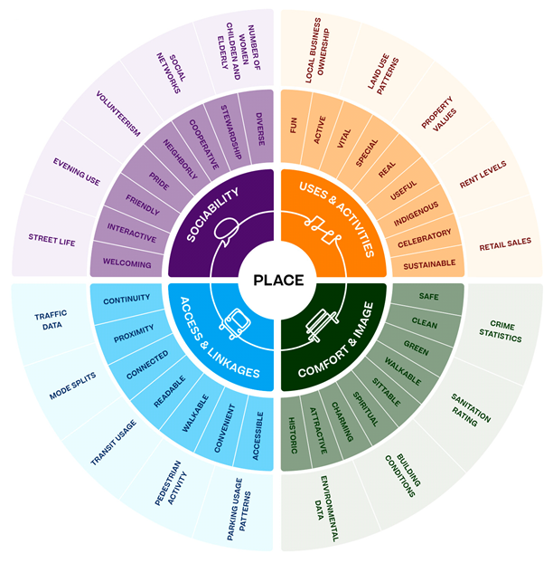
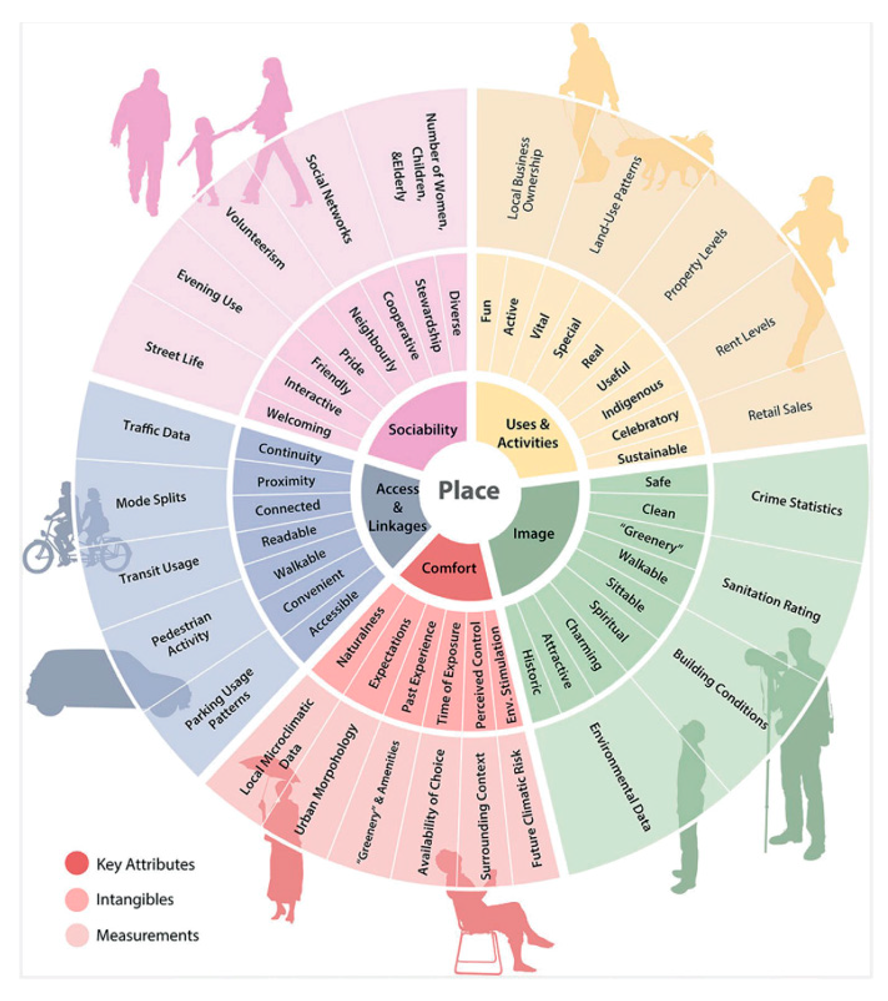
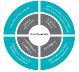
Table A2.
Second Group of Models.
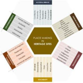

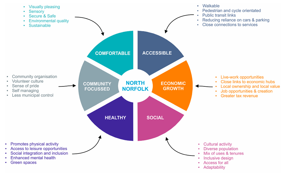
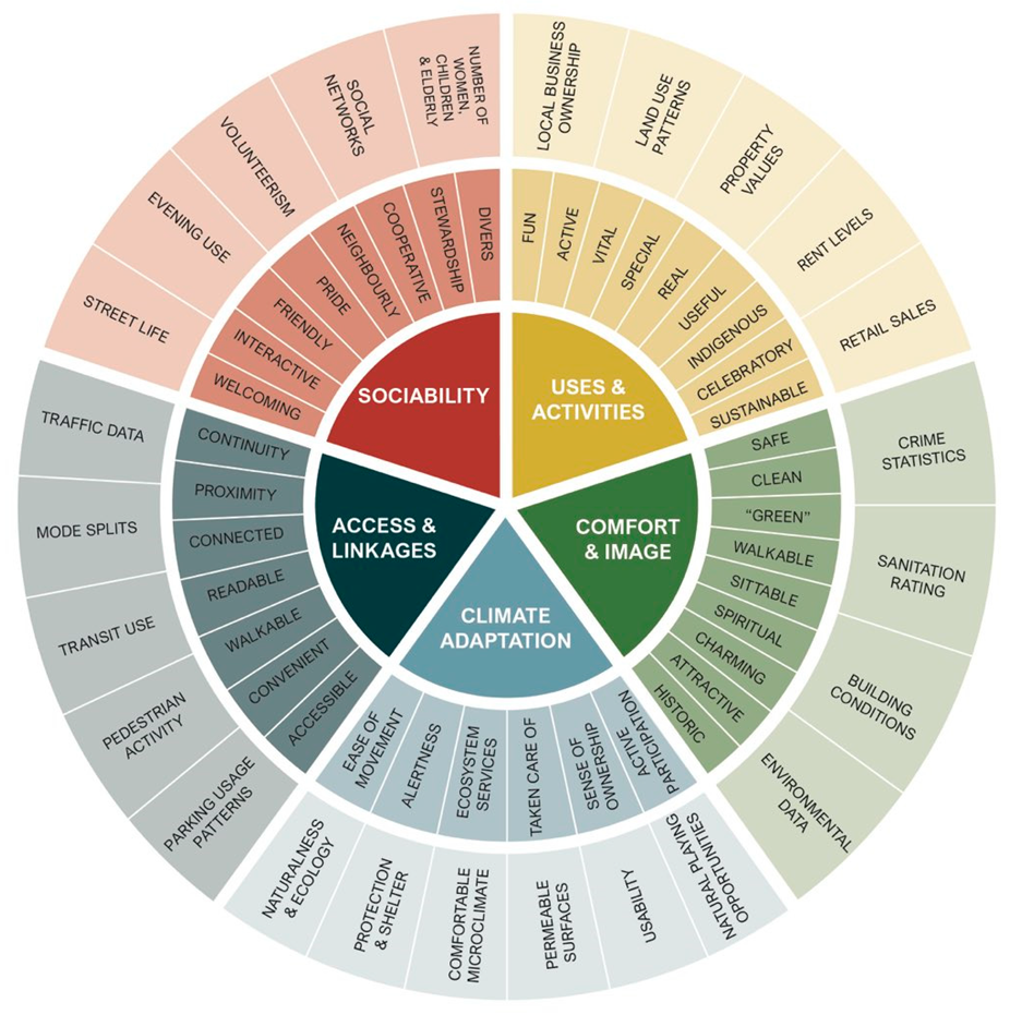
Table A3.
Third Group Models.
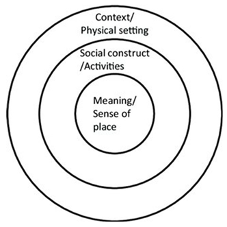
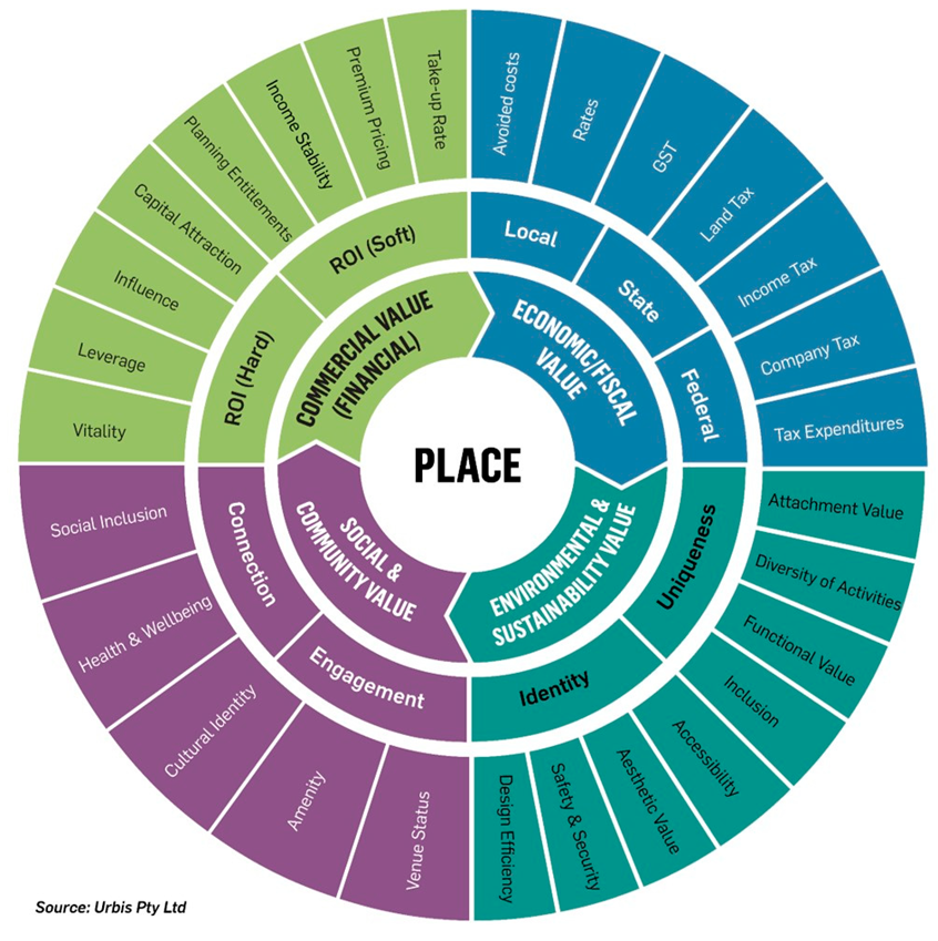
Table A4.
Fourth Group Models.
Appendix B
Table A5.
The placemaking practical framework (checklist). Sociability (Framework) Section. Source Author.
Table A6.
Physical Setting (Framework) Section.
Table A7.
Imageability (Framework) Section.
Appendix C
| Questionnaire Ministry of Higher Education and Scientific Research Salahaddin University College of Engineering Architectural Department Research Title Placemaking Strategies Enhancing the Livability of Commercial Streets in Erbil City | |
| Dear Sir/Madam | |
| This is a pure academic thesis work to cover part of the requirements for obtaining a Ph.D. in Architectural Engineering at Salahalddin University, College of Engineering, Architectural Department. The study aims to assess Livability in commercial streets by activating placemaking steps, as well as how it will affect pedestrian’s life in the street. This questionnaire includes a set of questions that will be answered by Architects, Architectural Academics (Master’s and Ph.D. holders), to identify the best design strategies for commercial streets regarding enhancing livability. Please read each question and each choice carefully and give an appropriate answer according to your experience and understanding of the topic. Bear in mind that, this information is purely academic. Your cooperation and participation are very important in supporting the research and its results. Thank you for your valuable help. | |
| Ph.D. Student; Ansam Saleh Al Hadidi | |
| Dr. Saalahaddin Yasin | |
| Email: Ansam.ali@su.edu.krd | |
| Mobile: 07706518931 | |
Table A8.
The Questionnaire List. Source: Author.







References
- Rahman, N.A.; Shamsuddin, S.; Ghani, I. What Makes People Use the Street? Towards a Liveable Urban Environment in Kuala Lumpur City Centre. Procedia. Soc. Behav. Sci. 2015, 170, 624–632. [Google Scholar] [CrossRef] [Scilit]
- Appleyard, D. Livable Streets: Protected Neighborhoods? Ann. Am. Acad. Politi-Soc. Sci. 1980, 451, 106–117. [Google Scholar] [CrossRef] [Scilit]
- Jacobs, A.; Appleyard, D. Toward an Urban Design Manifesto. J. Am. Plan. Assoc. 1987, 53, 112–120. [Google Scholar] [CrossRef] [Scilit]
- Marthya, K.; Furlan, R.; Ellath, L.; Esmat, M.; Al-Matwi, R. Place-Making of Transit Towns in Qatar: The Case of Qatar National Museum-Souq Waqif Corridor. Designs 2021, 5, 18. [Google Scholar] [CrossRef] [Scilit]
- Clos, J. The City at Eye Level: Lessons for Street Plinths. 2016. Available online: https://thecityateyelevel.com/app/uploads/2018/06/eBook_The.City_.at_.Eye_.Level_English.pdf (accessed on 8 February 2023).
- Gehl, J. Cities for People; Island Press: Washington, WA, USA, 2010; Available online: https://umranica.wikido.xyz/repo/7/75/Cities_For_People_-_Jan_Gehl.pdf. (accessed on 8 February 2023).
- Kent, F.; Project of Public Spaces (PPS). INQUIRIES@PPS.ORG OR 212.620.5660. 2020. Available online: https://www.pps.org/category/placemaking (accessed on 10 April 2023).
- Jacobs, J. The Death and Life of Great American Cities, 1st ed.; Random House: Totonto, ON, Canada, 1961; Vintage Books. New York: Urban Renewal—United States.3. Urban Policy—United States I. TitleHT167.J33 1992; Available online: https://www.buurtwijs.nl/sites/default/files/buurtwijs/bestanden/jane_jacobs_the_death_and_life_of_great_american.pdf (accessed on 8 February 2023).
- Non-profit foundation. Placemaking Week Europe. 27 September 2022. Available online: https://placemaking-europe.eu/ (accessed on 7 February 2023).
- Nohra, R.; Salha, C. Placemaking: Putting Life and Soul into Neighborhood Spaces; Hospitality News Middle East, 2 July 2018. Available online: https://www.hospitalitynewsmag.com/placemaking-putting-life-and-soul-into-neighborhood-spaces/ (accessed on 7 February 2023).
- Mohamed, A.M.; Samarghandi, S.; Samir, H.; Mohammed, M.F. The Role of Placemaking Approach in Revitalising AL-ULA Heritage Site: Linkage and Access as Key Factors. Int. J. Sustain. Dev. Plan. 2020, 15, 921–926. [Google Scholar] [CrossRef] [Scilit]
- North Norfolk District Council. 2023. Available online: https://designguide.north-norfolk.gov.uk/getting-started/the-value-of-placemaking/ (accessed on 8 February 2023).
- Nouri, A.S.; Costa, J.P. Placemaking and climate change adaptation: New qualitative and quantitative considerations for the “Place Diagram”. J. Urban. Int. Res. Placemak. Urban Sustain. 2016, 10, 356–382. [Google Scholar] [CrossRef] [Scilit]
- Ellery, P.J.; Ellery, J.; Borkowsky, M. Toward a Theoretical Understanding of Placemaking. Int. J. Community Well-Being 2020, 4, 55–76. [Google Scholar] [CrossRef] [Scilit]
- Ghavampour, E.; Vale, B. Revisiting the “Model of Place”: A Comparative Study of Placemaking and Sustainability. Urban Plan. 2019, 4, 196–206. [Google Scholar] [CrossRef] [Scilit]
- Backen, J. The Value of Placemaking; The City at Eye Level Asia, 4 November 2020. Available online: https://thecityateyelevel.com/stories/the-value-of-placemaking/ (accessed on 7 February 2023).
- Pike, O.M.; Durney, M. Urban Design Manual A best practice guide A companion document to the Guidelines for Planning Authorities on Sustainable Residential Development in Urban Areas. Ireland and across Europe, May 2009. Available online: https://www.opr.ie/wp-content/uploads/2019/08/1999-Urban-Design-Manual-1.pdf (accessed on 7 February 2023).
- Al-Kodmany, K. High-Rise Buildings Placemaking in the High-Rise City: Architectural and Urban Design Analyses. Int. J. High-Rise 2013, 2, 153–169. Available online: https://www.ctbuh-korea.org/ijhrb/index.php (accessed on 10 April 2023).
- National Associations of Realtors. Placemaking: Big Impacts, Small Towns. 13 January 2020. Available online: https://www.nar.realtor/blogs/spaces-to-places/placemaking-big-impacts-small-towns (accessed on 21 February 2023).
- Aras an Chontae. Urban Centres & Placemaking 7. Mullingar, Mount Street. Available online: https://consult.westmeathcoco.ie/en/consultation/draft-westmeath-county-development-plan-2021-2027/chapter/07-urban-centres-and-place-making (accessed on 8 February 2023).
- Cresswell, T. Place: A Short Introduction, 13th ed.; Blackwell Publishing: Carlton, Australia, 2004; Available online: https://docplayer.net/87556924-Place-a-short-introduction-tim-cresswell-ij-blackwell-l-publishing.html (accessed on 8 February 2023).
- Lynch, K. The Image of the City, 20th ed.; The M.I.T. Press: London, UK, 1961. [Google Scholar]
- Aravot, I. Back to Phenomenological Placemaking. J. Urban Des. 2002, 7, 201–212. [Google Scholar] [CrossRef] [Scilit]
- Toolis, E.E. Theorizing Critical Placemaking as a Tool for Reclaiming Public Space. Am. J. Community Psychol. 2017, 59, 184–199. [Google Scholar] [CrossRef] [Scilit]
- Seamon, D.; Sowers, J. Key Texts in Human Geography. In Place and Placelessness, Edward Relph (1976); SAGE Publications Inc.: London, UK, 2008; pp. 43–52. [Google Scholar] [CrossRef] [Scilit]
- Ryfield, F.; Cabana, D.; Brannigan, J.; Crowe, T. Conceptualizing ‘sense of place’ in cultural ecosystem services: A framework for interdisciplinary research. Ecosyst. Serv. 2019, 36, 100907. [Google Scholar] [CrossRef] [Scilit]
- Shamsuddin, S.; Al-Obeidy, M.S. Evaluating Diversity of Commercial Streets by the Approach of Sense of Place. Adv. Environ. Biol. 2015, 9, 193–196. Available online: http://www.aensiweb.com/AEB/ (accessed on 10 April 2023).
- Fayez, S.; Supervisor, A.-N.; Kamel, D.; Mahadin, O. Towards a Comprehensive Approach to Defining Sense of Place And Character “The Street And The City Of Amman”. Ph.D. Thesis, Faculty of Graduate Studies, The University of Jordan, Amman, Jordan, 2004. [Google Scholar] [CrossRef]
- Khemri, M.Y.; Melis, A.; Caputo, S. Sustaining the Liveliness of Public Spaces in El Houma through Placemaking. J. Public Space 2020, 5, 129–152. [Google Scholar] [CrossRef] [Scilit]
- Mcdonough, J.T. Place-Making: A Study of Emerging Professionals’ Preferences of Place-Making Attributes. 2013. Available online: https://d.lib.msu.edu/etd/2768 (accessed on 9 February 2023).
- N. 10276 U. P.O. Box 1073 New York. The Power of 10+, How Cities Transform Through Placemaking. 2020. Available online: https://www.pps.org/article/the-power-of-10 (accessed on 21 February 2023).
- Alexander, C. A Pattern Language; Oxford University Press: New York, NY, USA, 1977. [Google Scholar]
- Alexander, C. New Concepts in Complexity Theory. 2003. Available online: http://www.katarxis3.com/SCIENTIFIC%20INTRODUCTION.pdf (accessed on 12 March 2023).
- Gehl, J. A Changing Street Life in a Changing Society. Places, 6. 1989. Available online: http://escholarship.org/uc/item/46r328ks (accessed on 9 February 2023).
- Gehl, J. Life between Buildings; Island Press: Washington, WA, USA, 2011; Available online: https://kupdf.net/download/jan-gehl-life-between-buildingspdf_59d293dd08bbc53f7868720b_pdf (accessed on 22 February 2023).
- Montgomery, J. Making a city: Urbanity, vitality and urban design. J. Urban Des. 1998, 3, 93–116. [Google Scholar] [CrossRef] [Scilit]
- Canter, D.V. The Psychology of Place; Architectural Press: Oxford, UK, 1977; p. 198. Available online: https://www.researchgate.net/publication/232600712_The_Psychology_of_Place (accessed on 22 February 2023).
- Rasouli, M. Analysis of Activity Patterns and Design Features Relationships in Urban Public Spaces Using Direct Field Observations, Activity Maps and GIS Analysis Mel Lastman Square in Toronto as a Case Study. Master’s Thesis, University of Waterloo, Waterloo, ON, Canada, 2013. Available online: https://uwspace.uwaterloo.ca/bitstream/handle/10012/7383/Rasouli_Mojgan.pdf;sequence=1 (accessed on 9 February 2023).
- Canter, D.V. The Facets of Place; Dartmouth. 1996, p. 330. Available online: https://www.researchgate.net/publication/247875806_The_Facets_of_Place (accessed on 22 February 2023).
- Seamon, D. ‘Awakening to the World as Phenomenon’. The Value of Phenomenology for a Pedagogy of Place and Place Making. In Phenomenology and Educational Theory in Conversation, 1st ed.; Taylor & Francis: Abingdon, UK, 2020; Available online: https://www.academia.edu/38299258/_Awakening_to_the_World_as_Phenomenon_The_Value_of_Phenomenology_for_a_Pedagogy_of_Place_and_Place_Making_2020 (accessed on 10 April 2023).
- Seamon, D. Life Takes Place, Phenomenology, Life Worlds, and Place Making, 1st ed.; Taylor & Francis: New York, NY, USA, 2018. [Google Scholar] [CrossRef] [Scilit]
- Abusaada, H.; Elshater, A. Effect of people on placemaking and affective atmospheres in city streets. Ain Shams Eng. J. 2021, 12, 3389–3403. [Google Scholar] [CrossRef] [Scilit]
- Ghazi, N.M.; Abaas, Z.R. Toward liveable commercial streets: A case study of Al-Karada inner street in Baghdad. Heliyon 2019, 5, e01652. [Google Scholar] [CrossRef] [Scilit]
- Carmona, M. Contemporary Public Space: Critique and Classification, Part One: Critique. J. Urban Des. 2010, 15, 123–148. [Google Scholar] [CrossRef] [Scilit]
- Mehta, V. Lively streets: Determining environmental characteristics to support social behavior. J. Plan Educ. Res. 2007, 27, 165–187. [Google Scholar] [CrossRef] [Scilit]
- Del Aguila, M.; Ghavampour, E.; Vale, B. Theory of place in public space. Urban Plan 2019, 4, 249–259. [Google Scholar] [CrossRef] [Scilit]
- Harb, D.F. Examining the Vibrancy of Urban Commercial Streets in Doha. Master’s Thesis, College of Engineering, Qatar University, Doha, Qatar, 2016. [Google Scholar]
- Hu, M.; Chen, R. A Framework for Understanding Sense of Place in an Urban Design Context. Urban Sci. 2018, 2, 34. [Google Scholar] [CrossRef] [Scilit]
- Marzbani, M.; Awad, J.; Rezaei, M. The Sense of Place: Components and Walkability. Old and New Developments in Dubai, UAE. J. Public Space 2020, 5, 21–36. [Google Scholar] [CrossRef] [Scilit]
- Al-Kodmany, K.M. Planning Guidelines for Enhancing Placemaking with Tall Buildings. Archnet-IJAR Int. J. Arch. Res. 2018, 12, 5–23. [Google Scholar] [CrossRef] [Scilit]
- Governorate, E. Erbil Governorate Profile. 2015. Available online: http://www.jauiraq.org/documents/380/GP-Erbil%202013.pdf (accessed on 10 February 2023).
- Governorate, E. Eskan Neighborhood Guide in Erbil, Iraq. Available online: https://guide.opensooq.com/%d8%a7%d9%84%d8%b9%d8%b1%d8%a7%d9%82/%d8%a3%d8%b1%d8%a8%d9%8a%d9%84/%d8%af%d9%84%d9%8a%d9%84-%d8%ad%d9%8a-%d8%a7%d9%84%d8%a5%d8%b3%d9%83%d8%a7%d9%86-%d9%81%d9%8a-%d8%a3%d8%b1%d8%a8%d9%8a%d9%84-%d8%a7%d9%84%d8%b9%d8%b1%d8%a7%d9%82/ (accessed on 22 February 2023).
- Mohammed, W.S.; Al-Jawari, S.M. Spatial Organization of Commercial Streets and Its Impact on the Urban Scene-A Case Study of Al-Jawahiri Street in Al-Najaf, Iraq the divan of Al-Najaf Al-Ashraf Governorate, the Construction Commission, the Resident Engineer Department for Kufa Projects. Int. J. Eng. Res. Technol. 2021, 10. Available online: www.ijert.org (accessed on 18 February 2021).
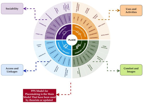
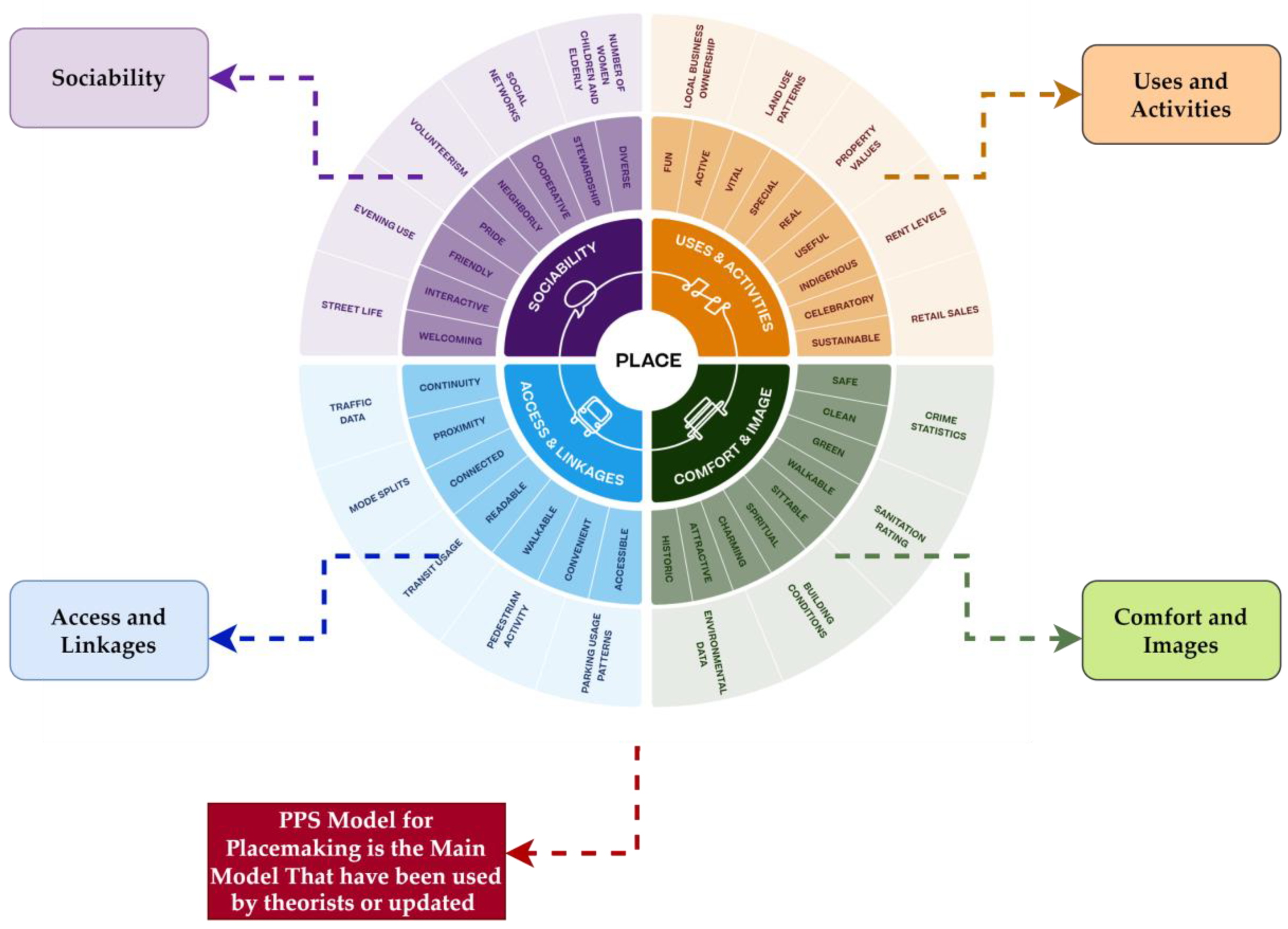
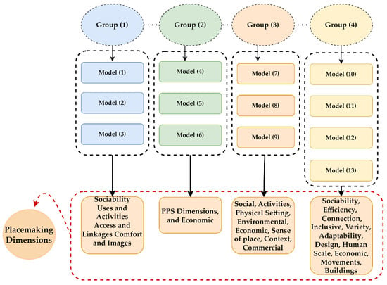
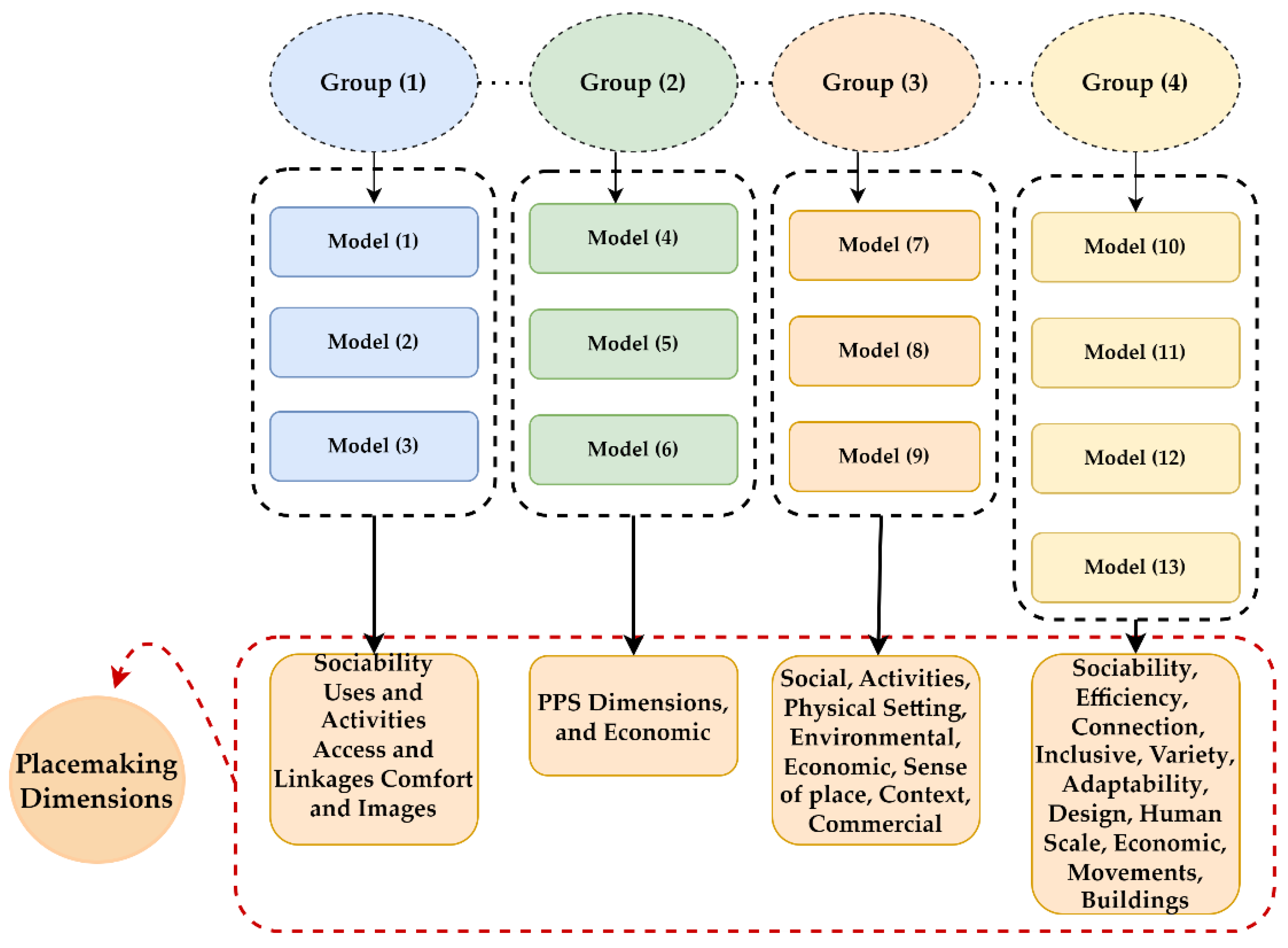
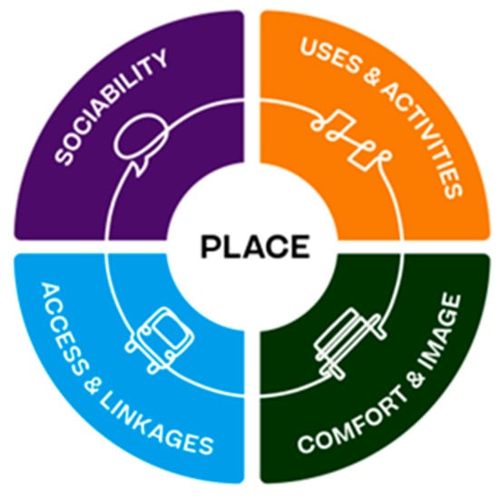
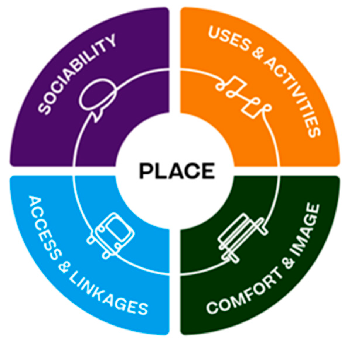
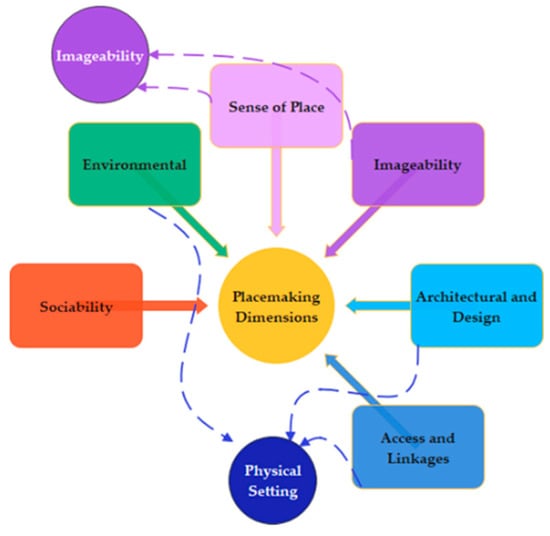
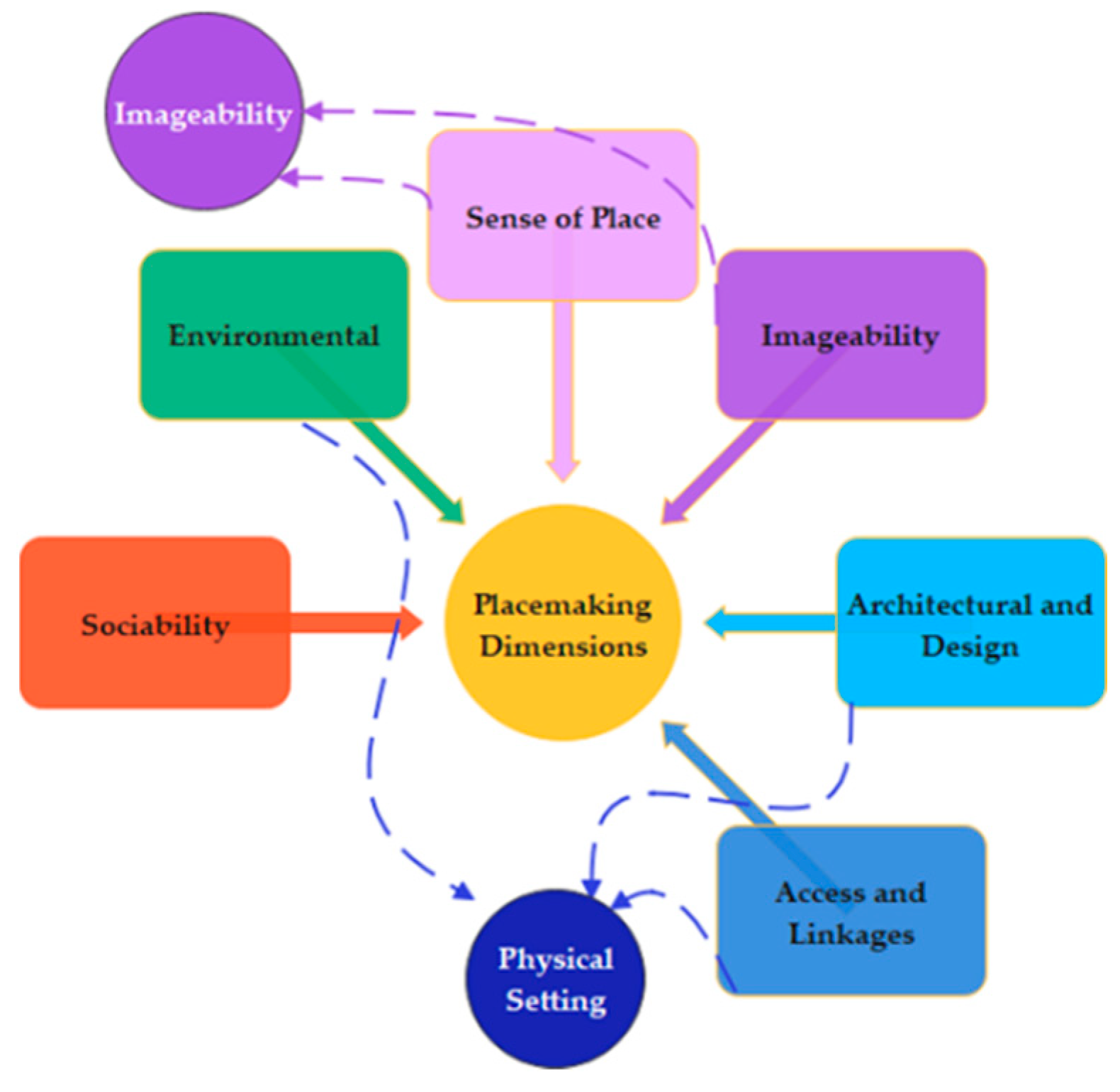
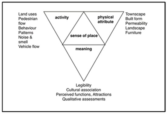
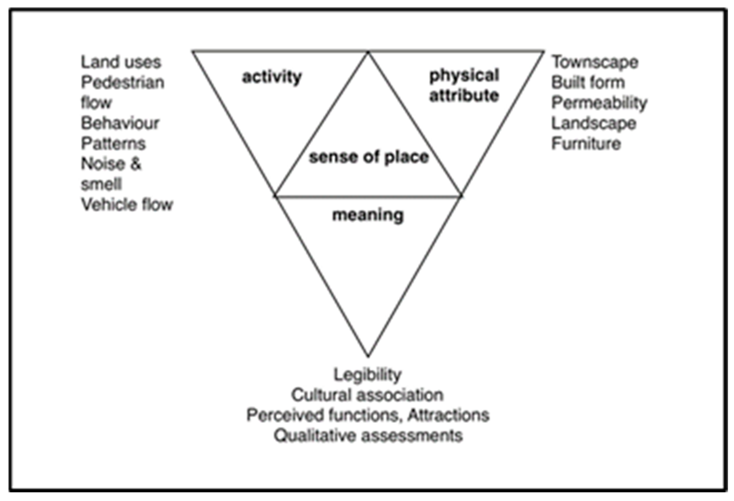
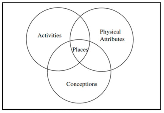
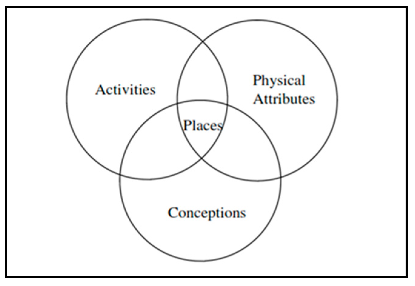
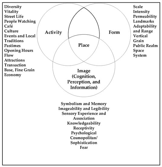
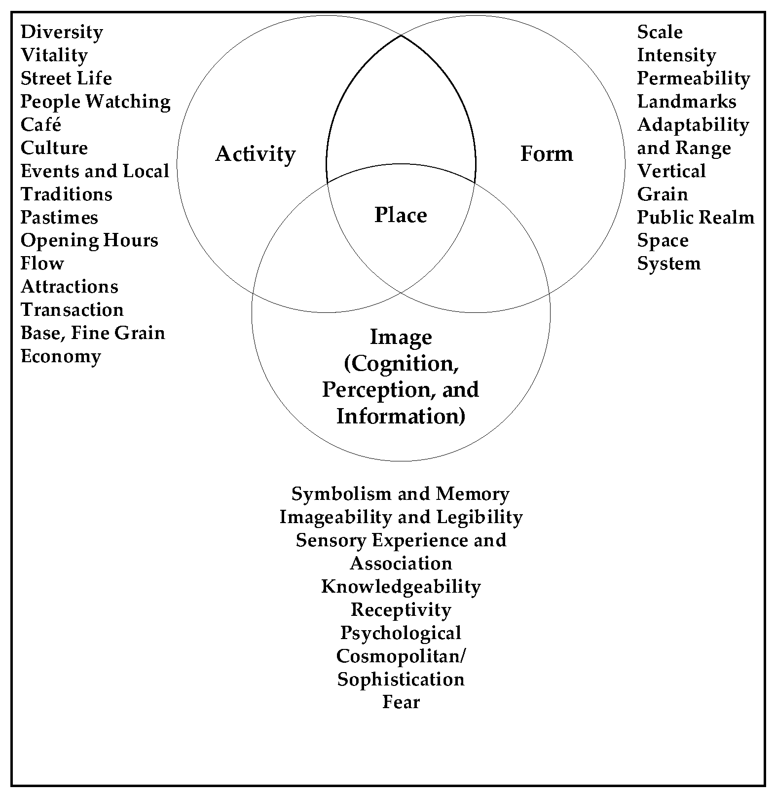
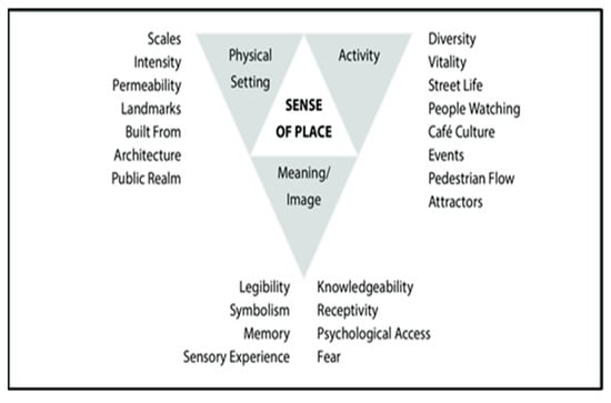
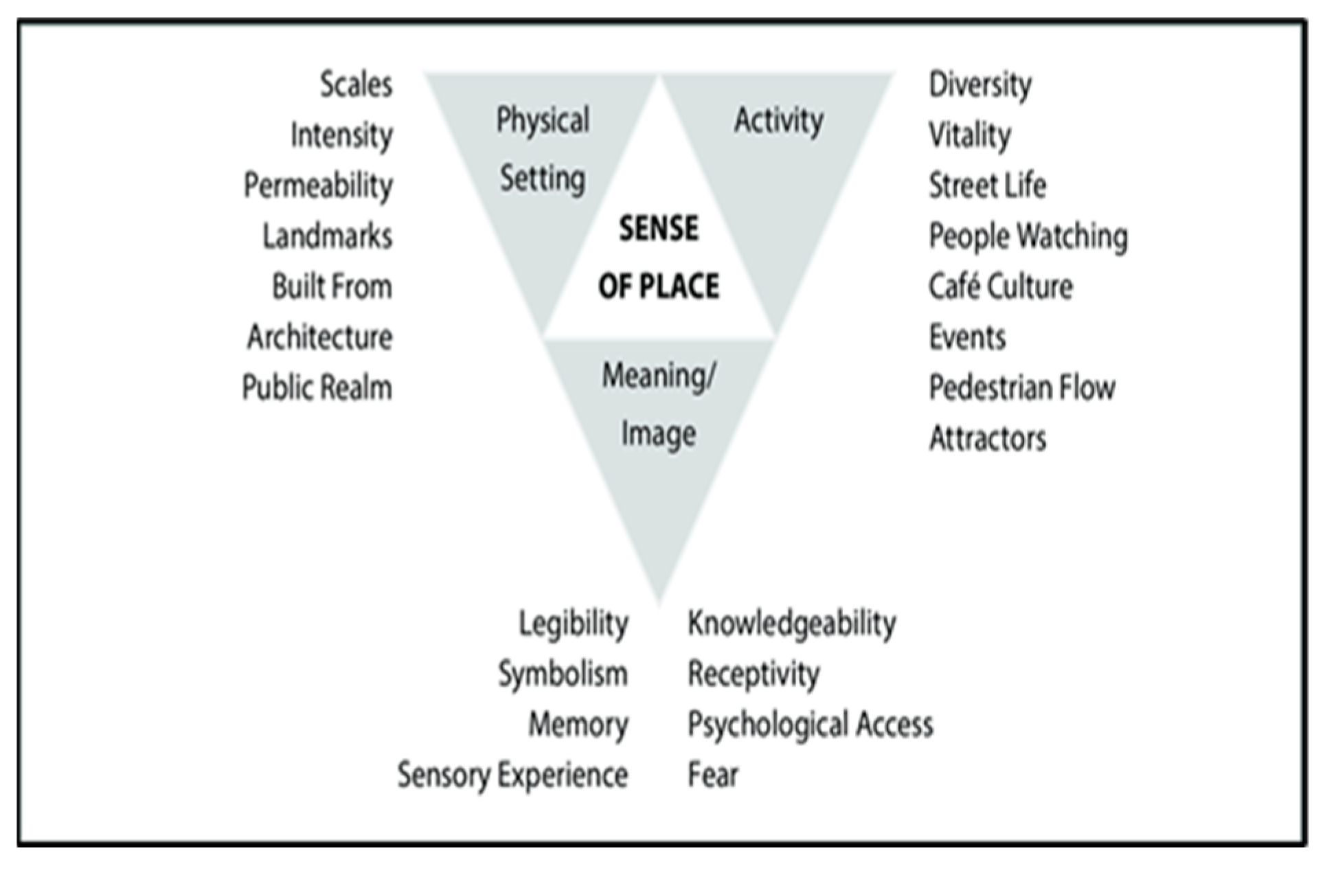
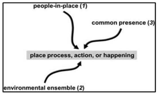
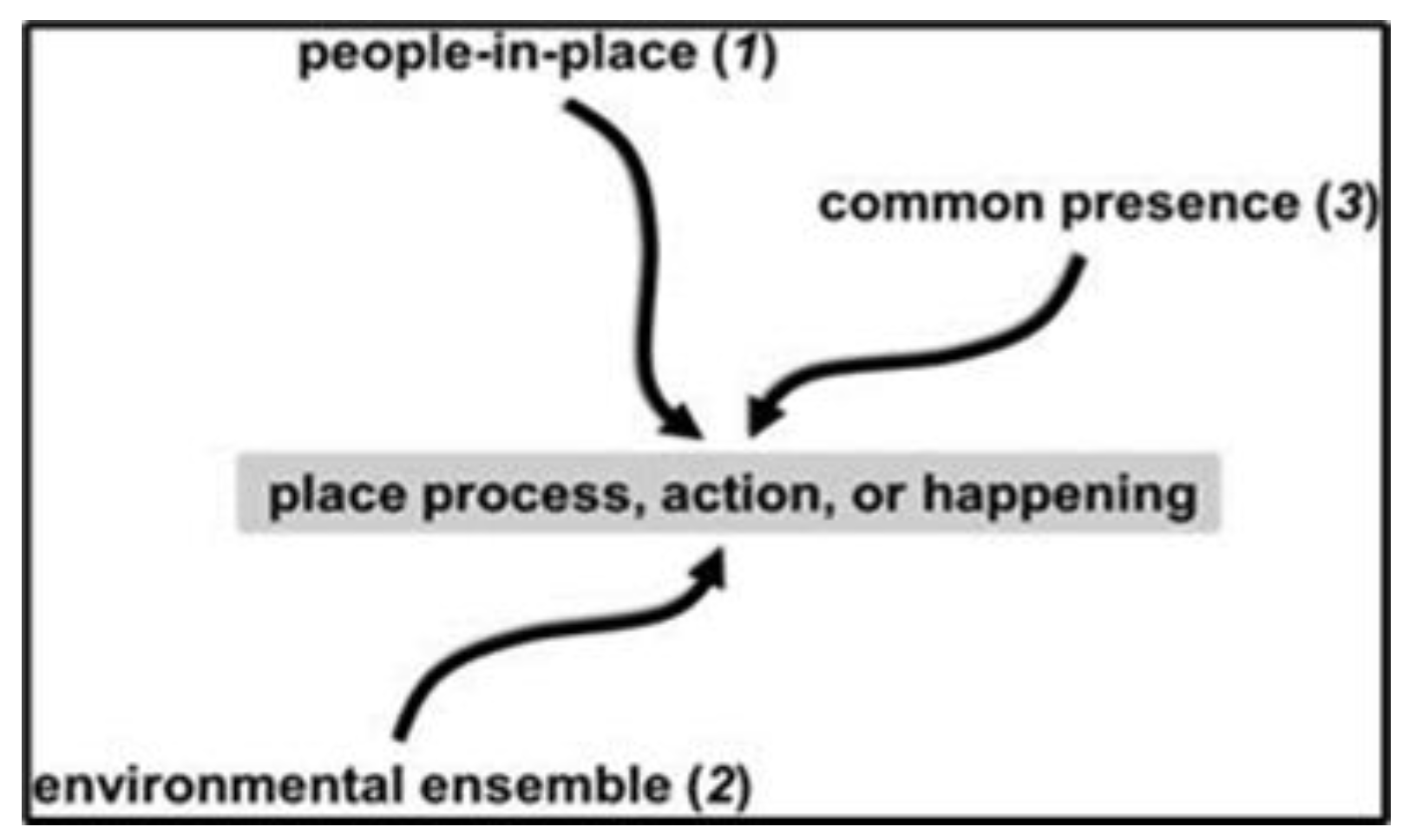
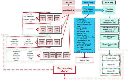
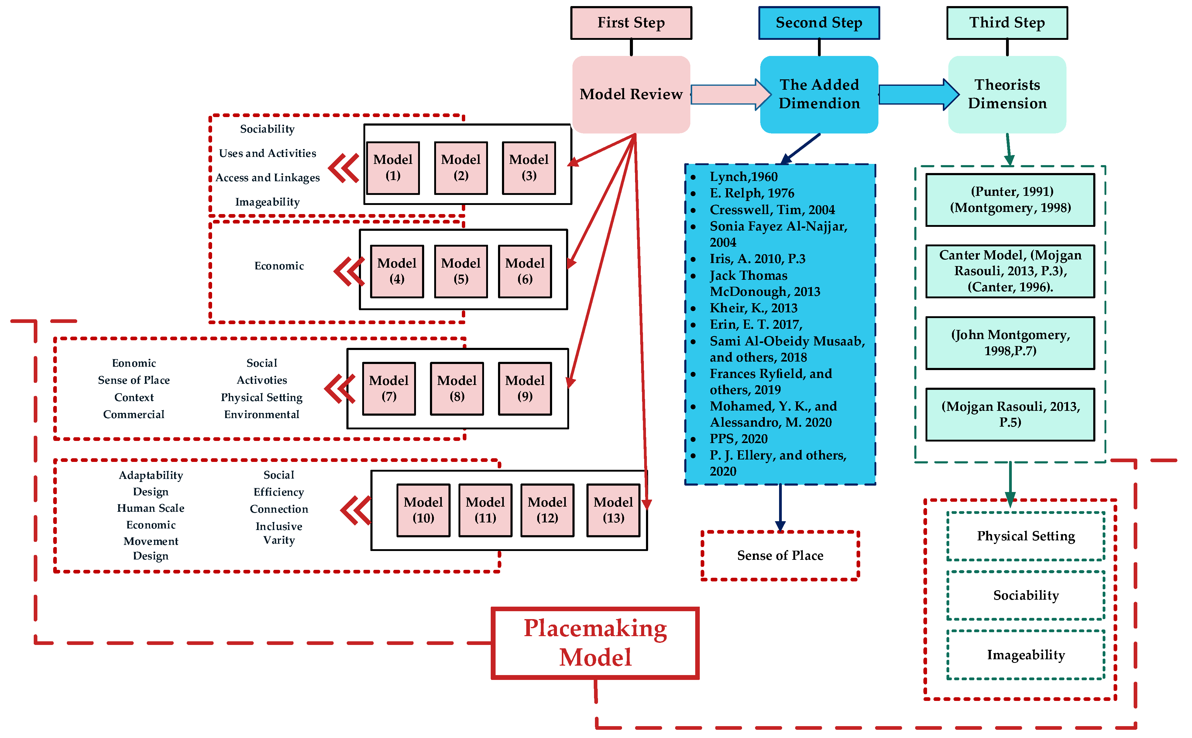
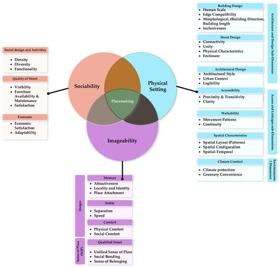
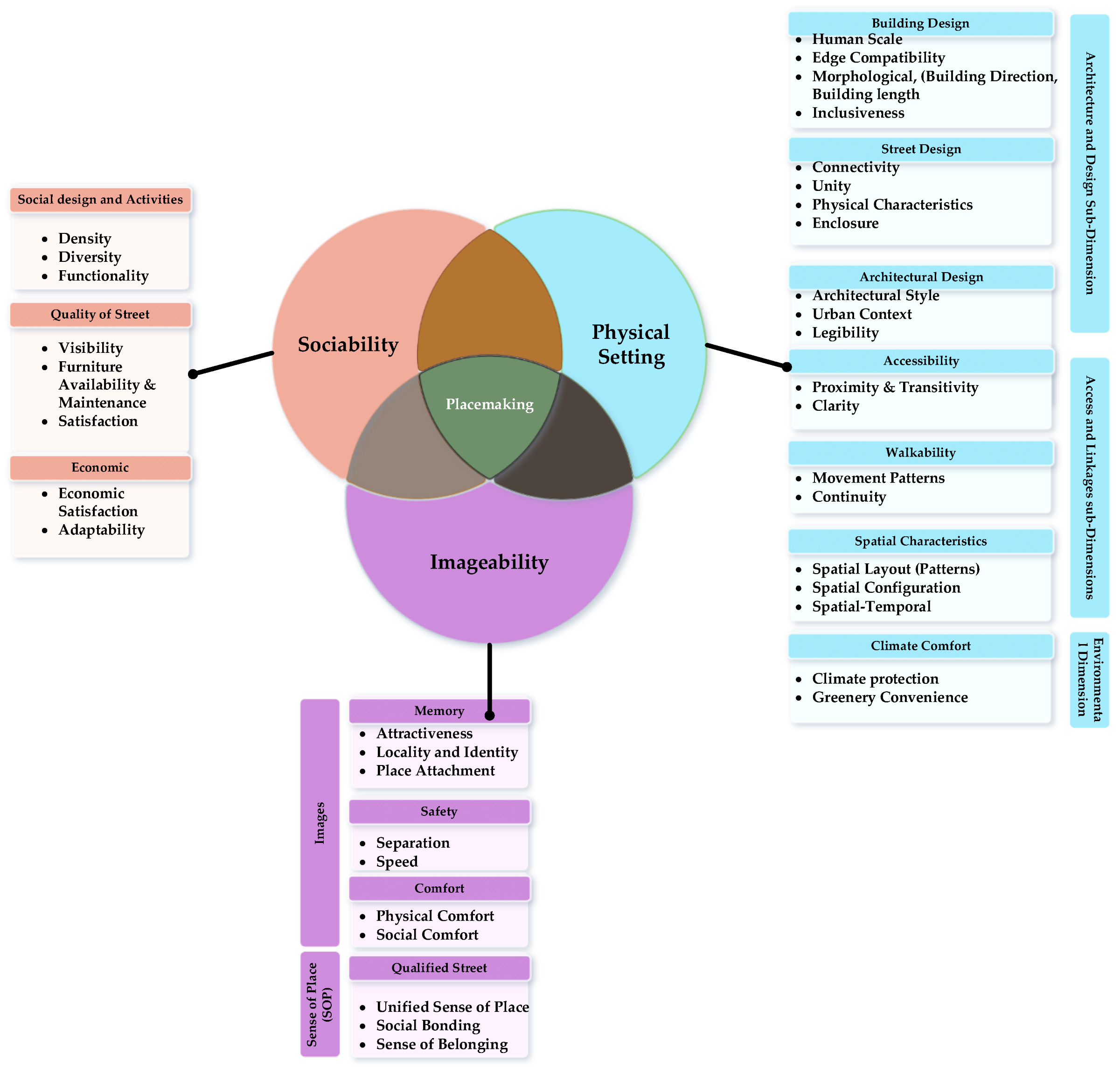
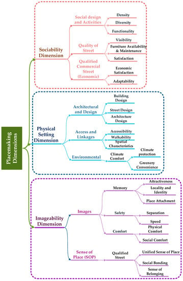
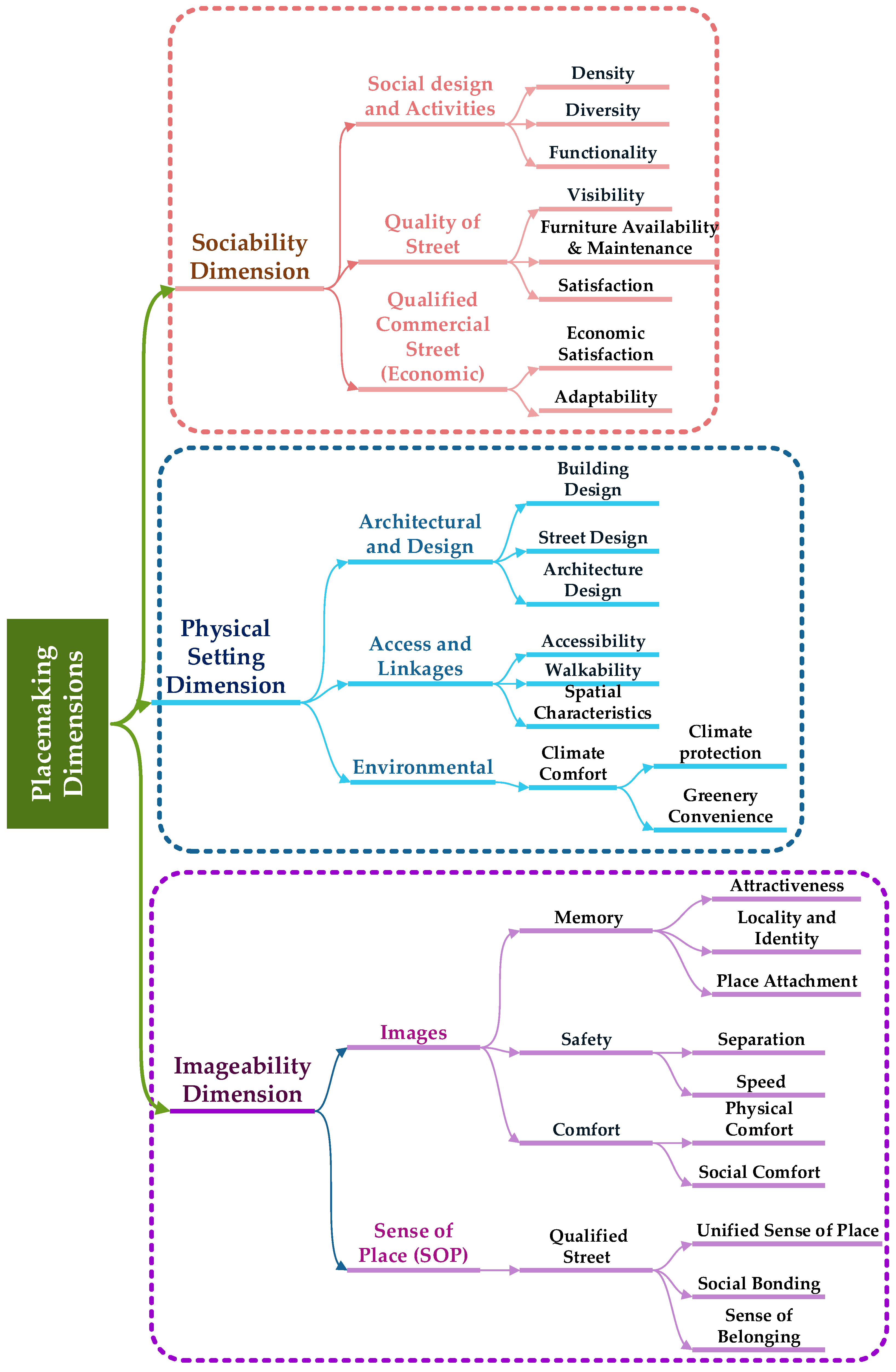
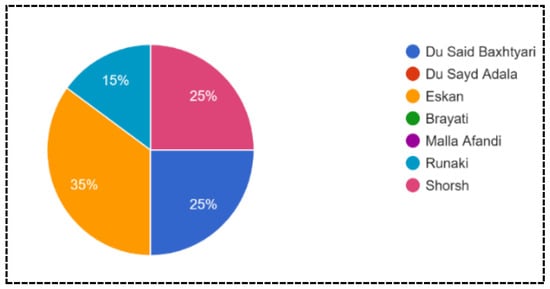
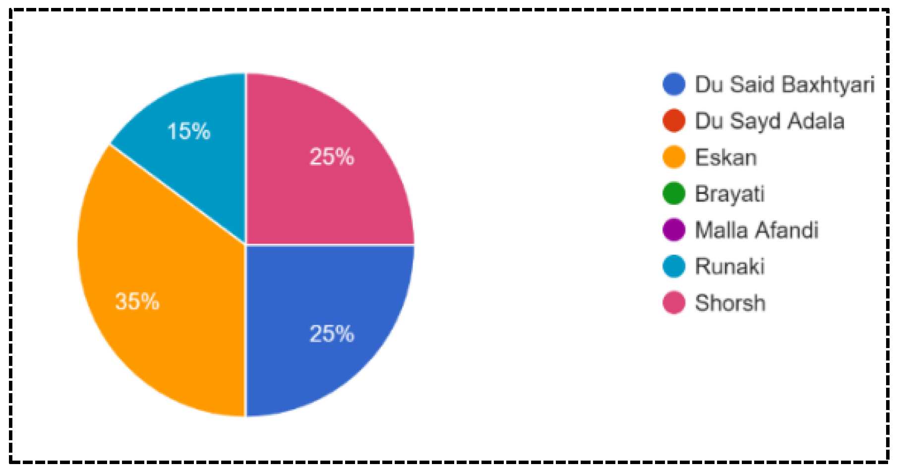
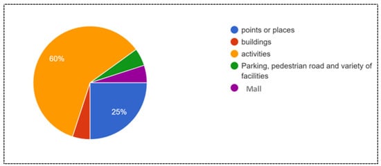
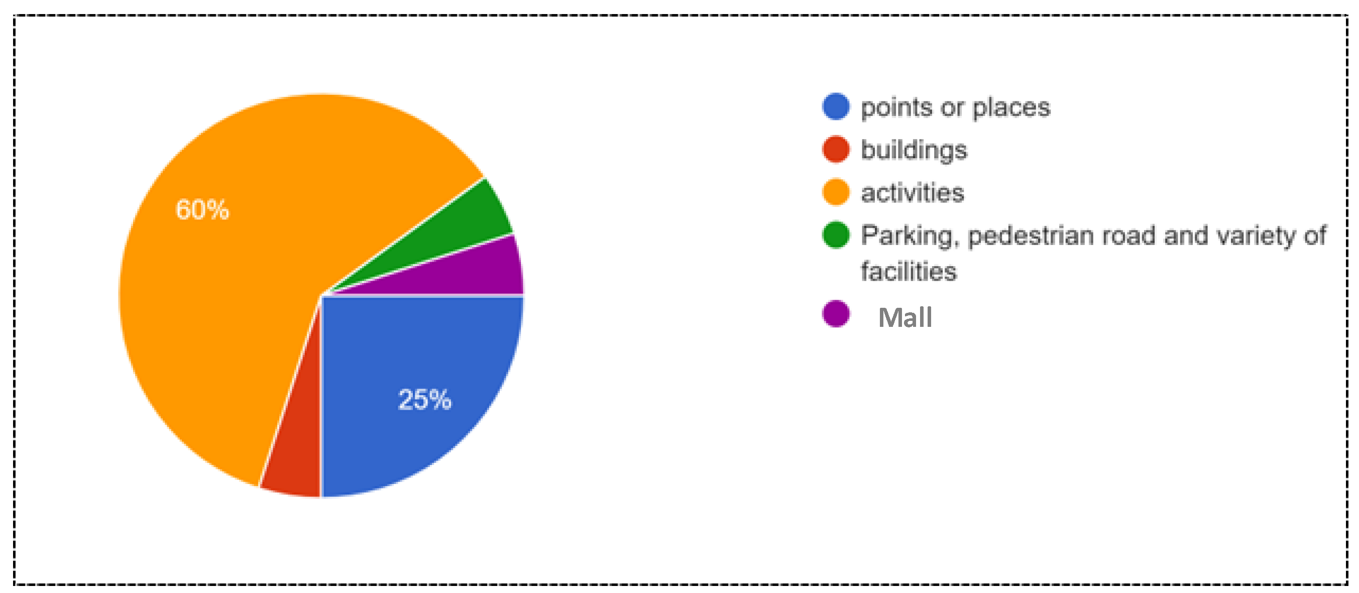
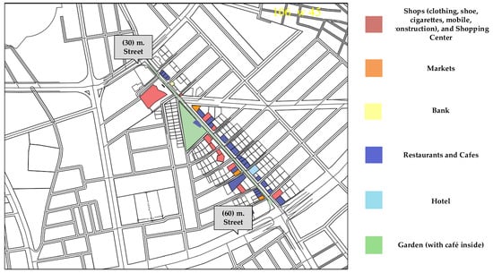
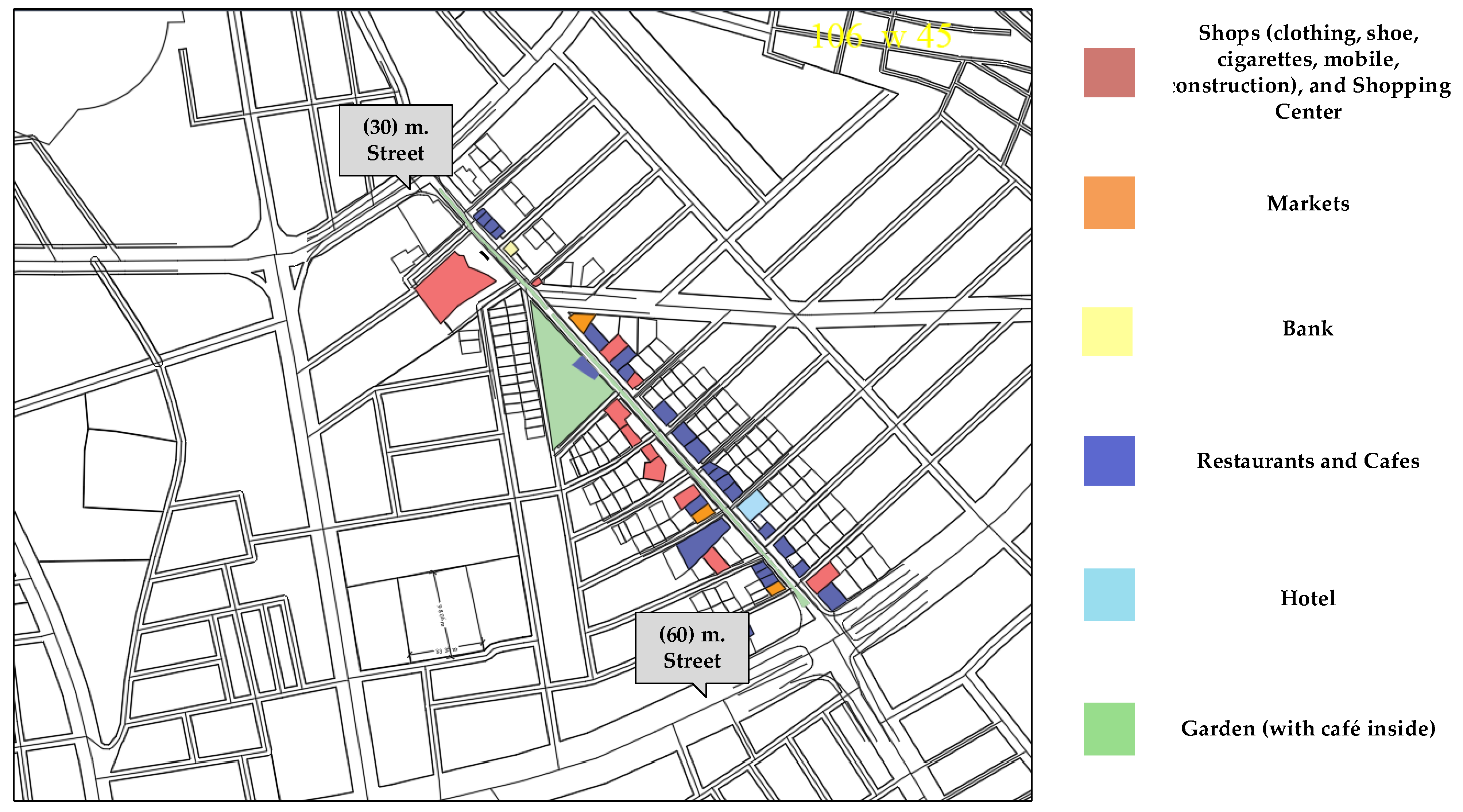
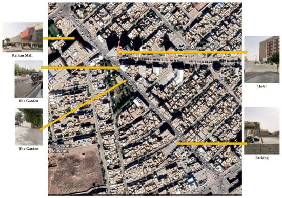
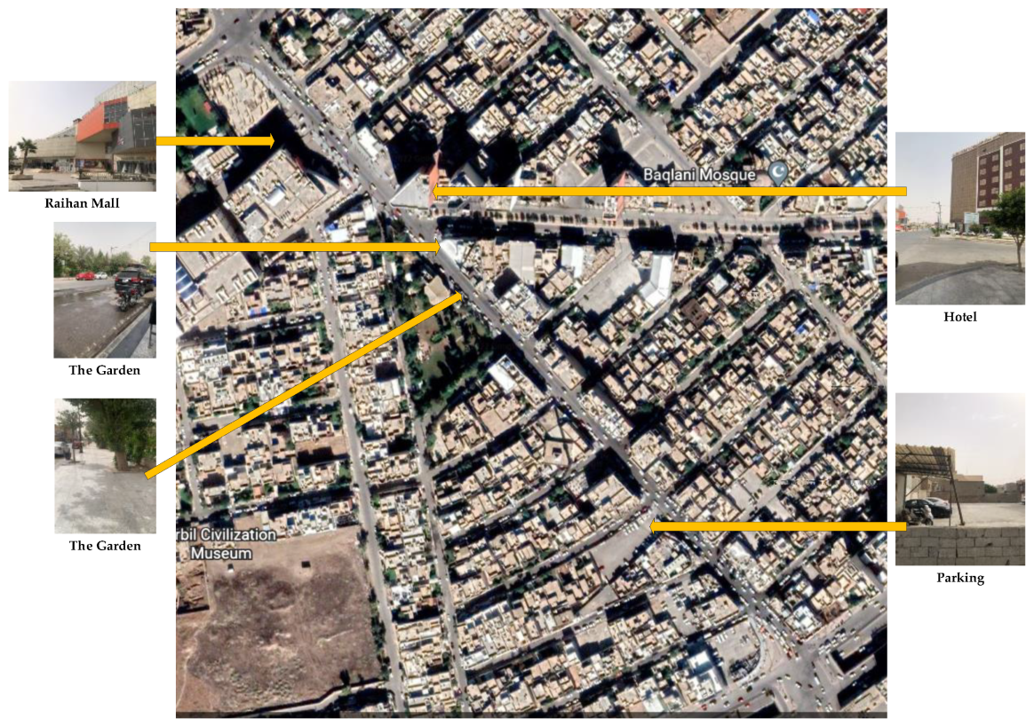
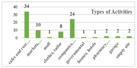
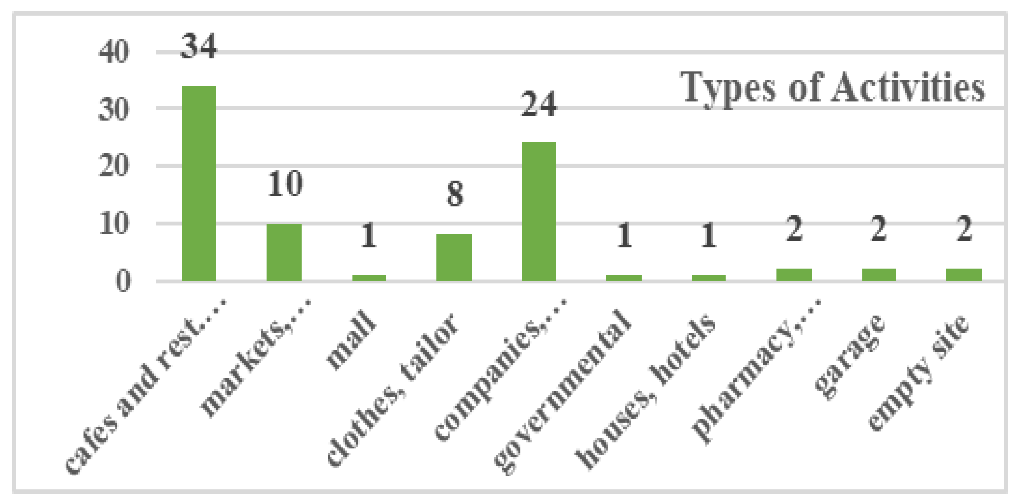
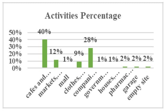
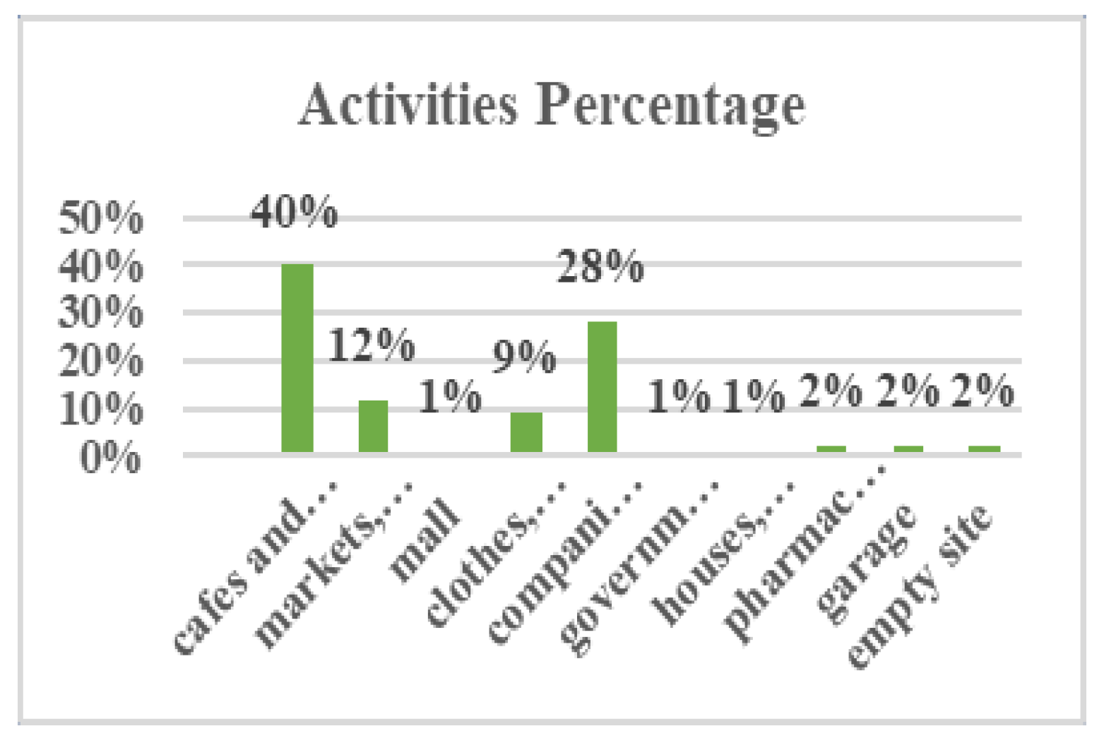
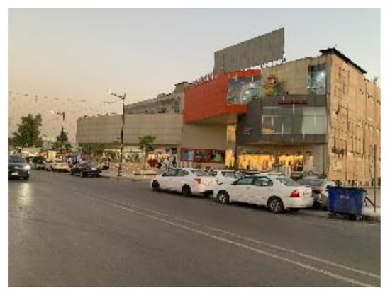
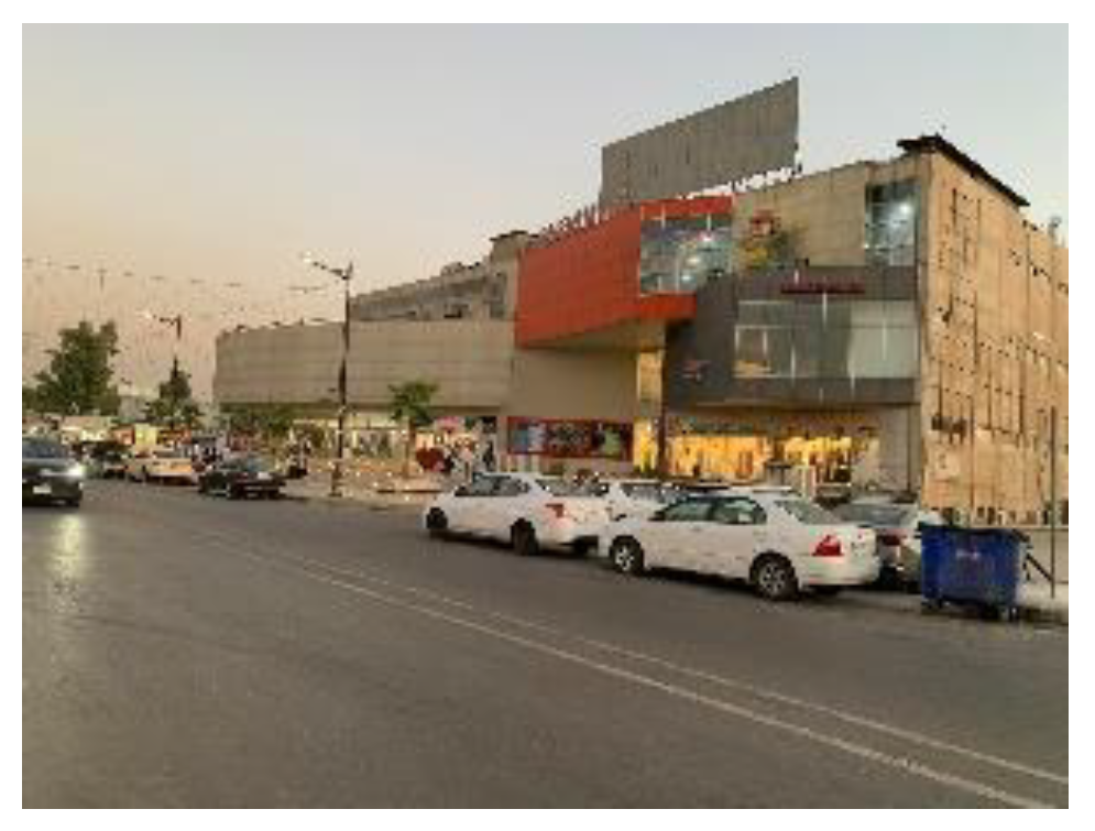
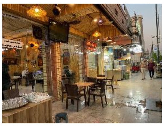
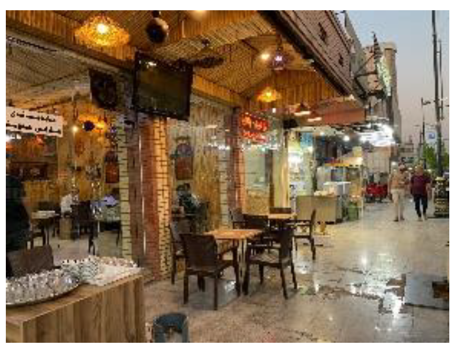
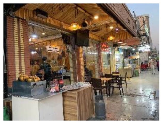
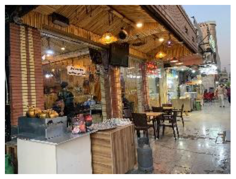
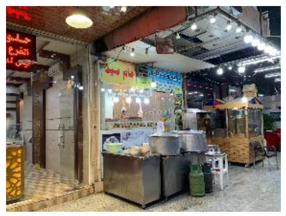
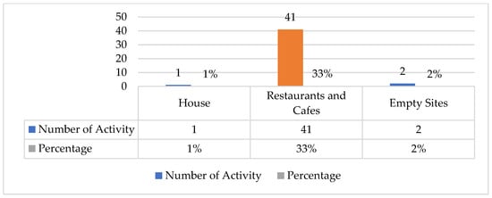
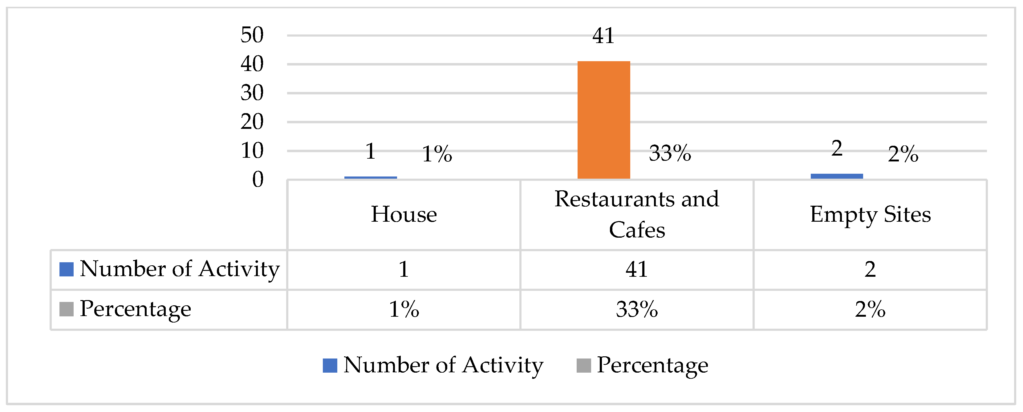
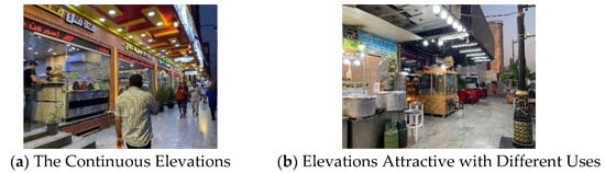
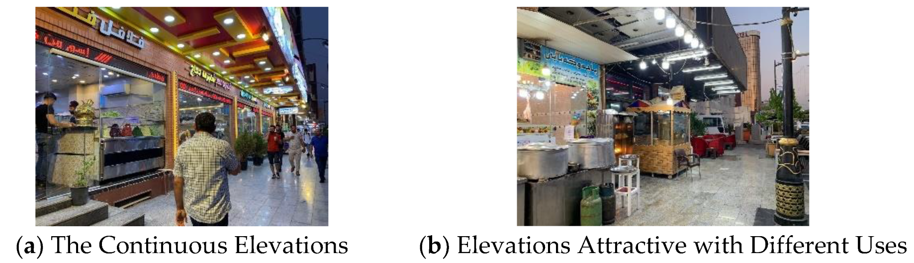
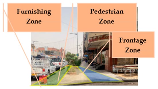
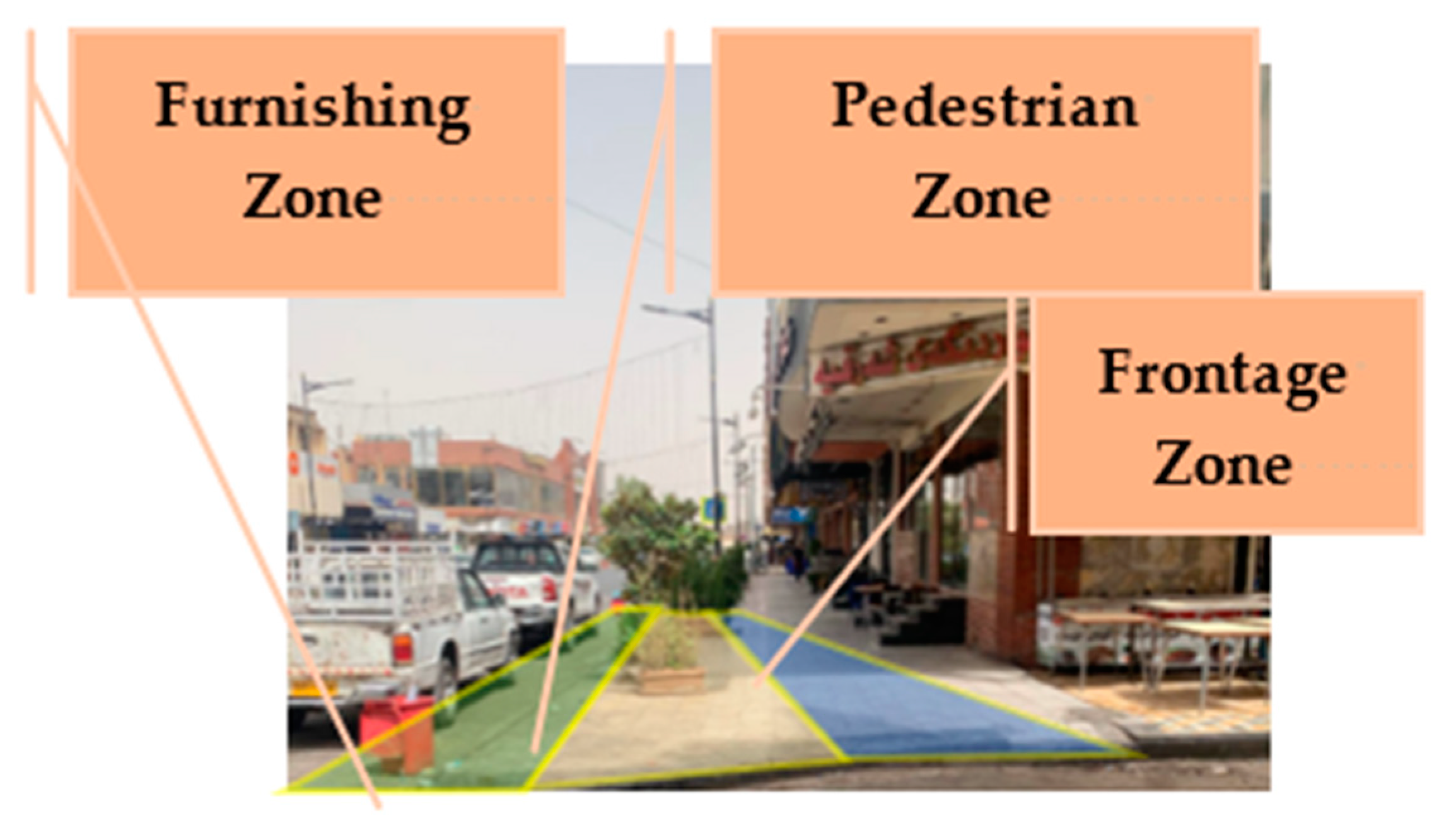
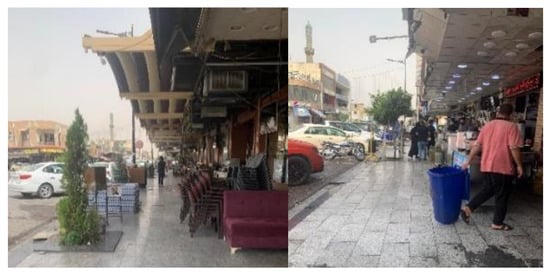
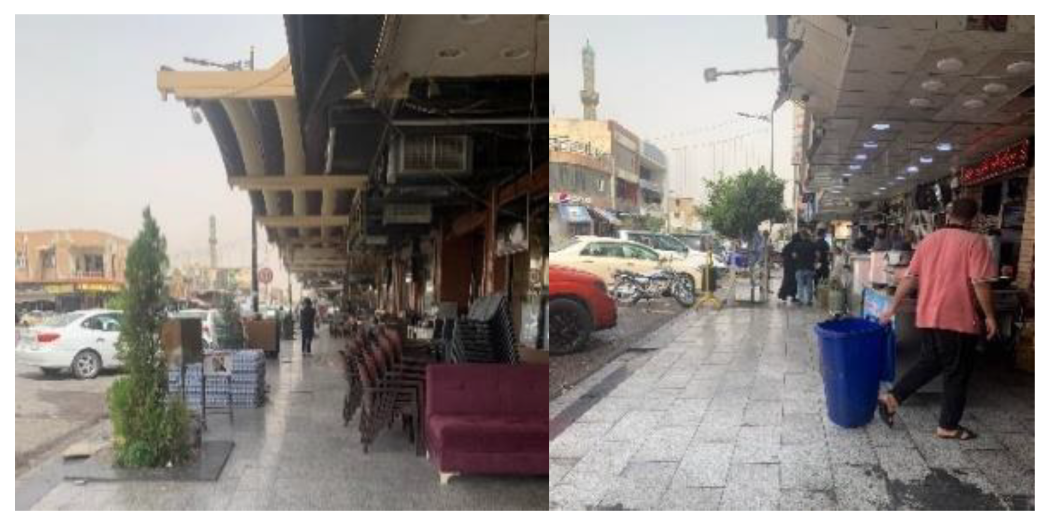
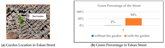
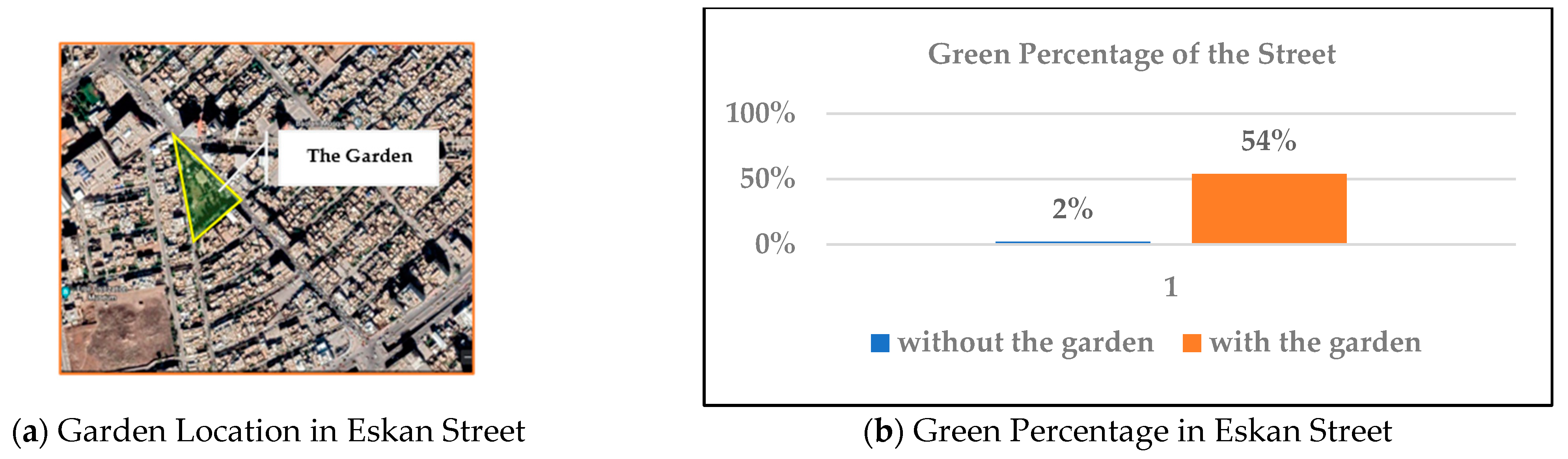
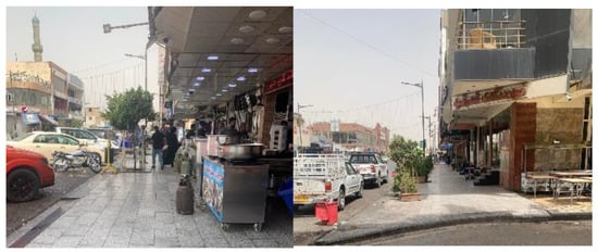
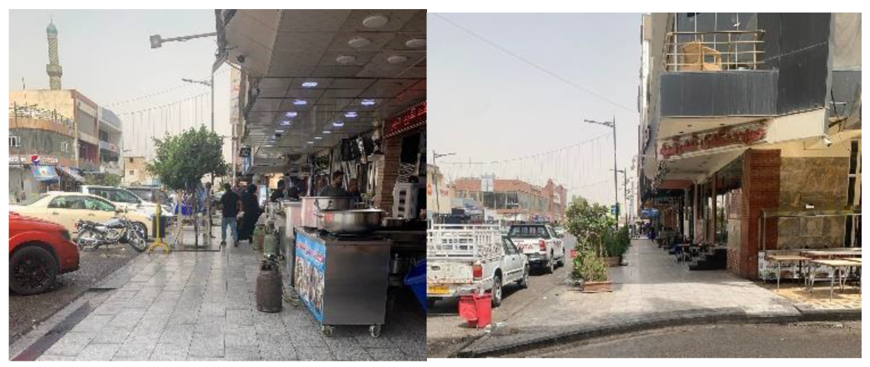
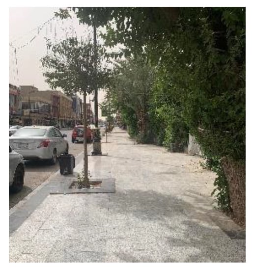
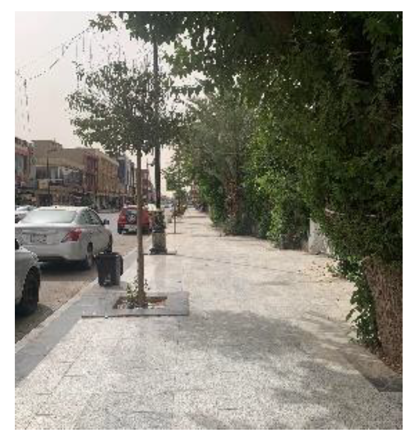
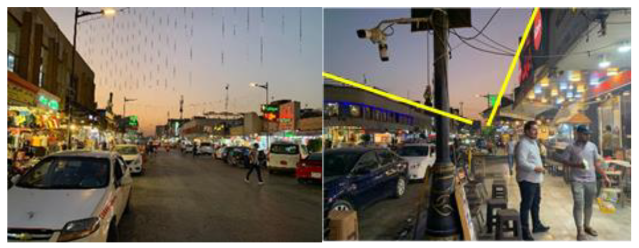
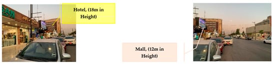
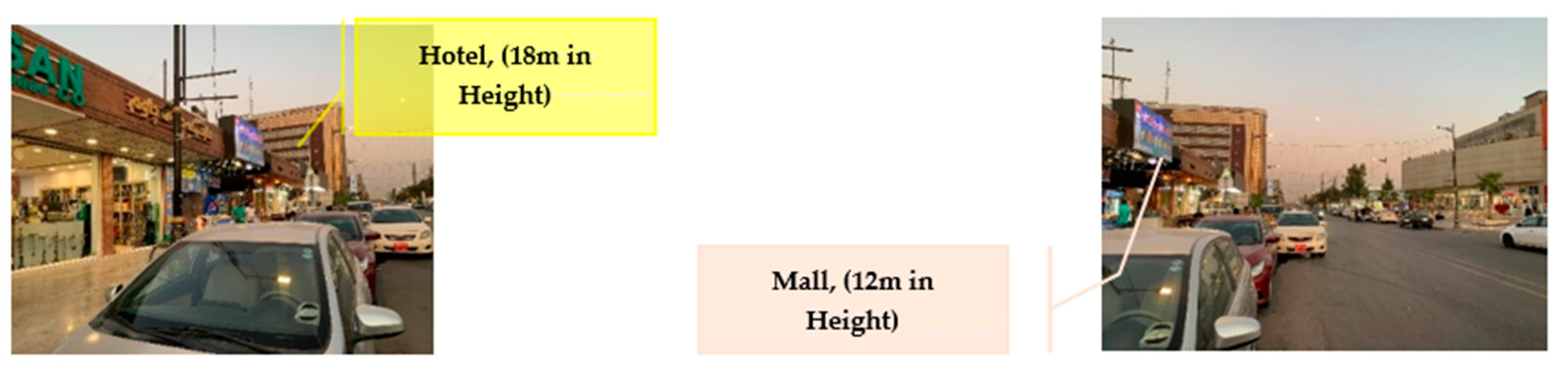
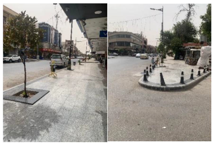
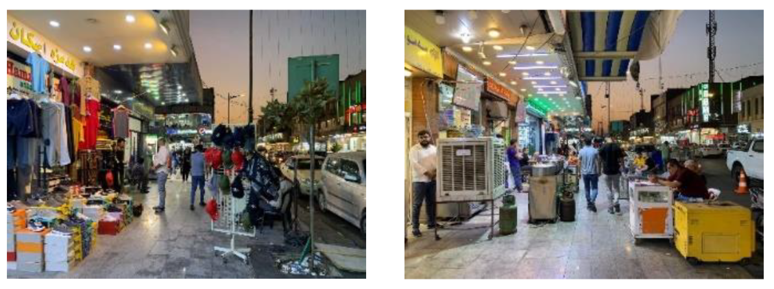
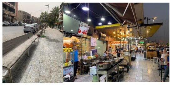
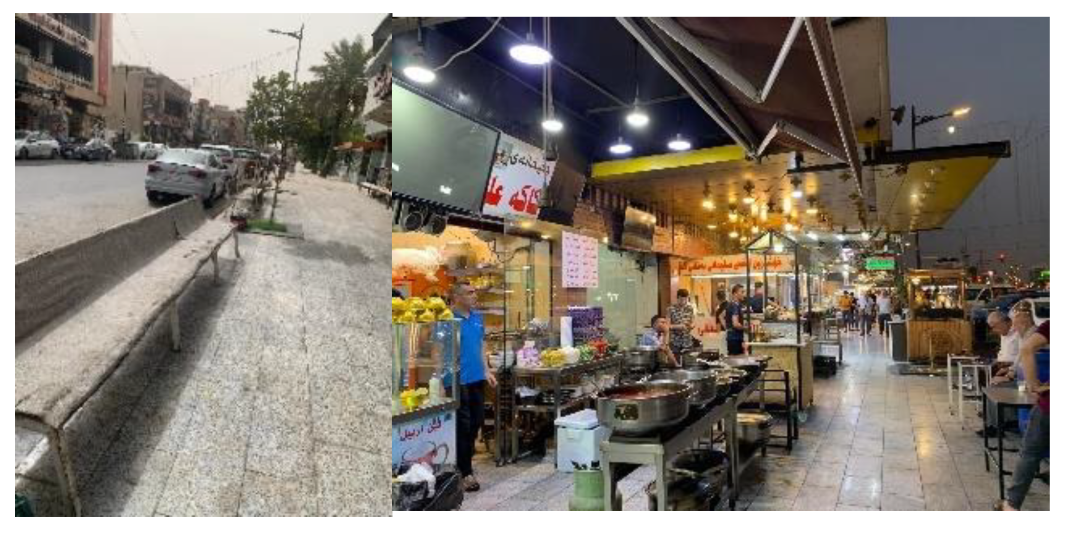
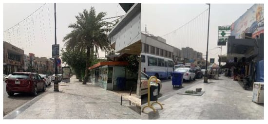
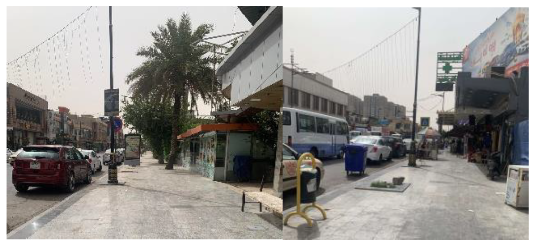
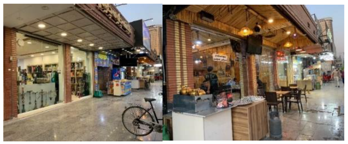
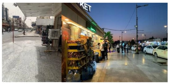
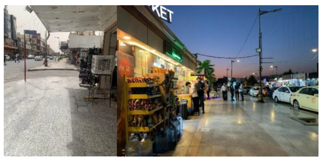
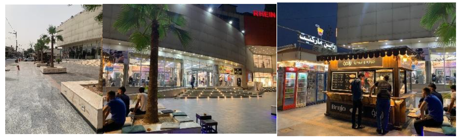
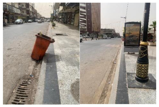
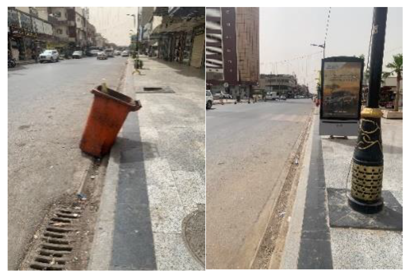
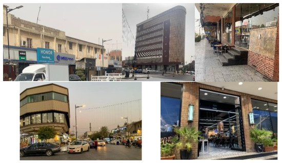
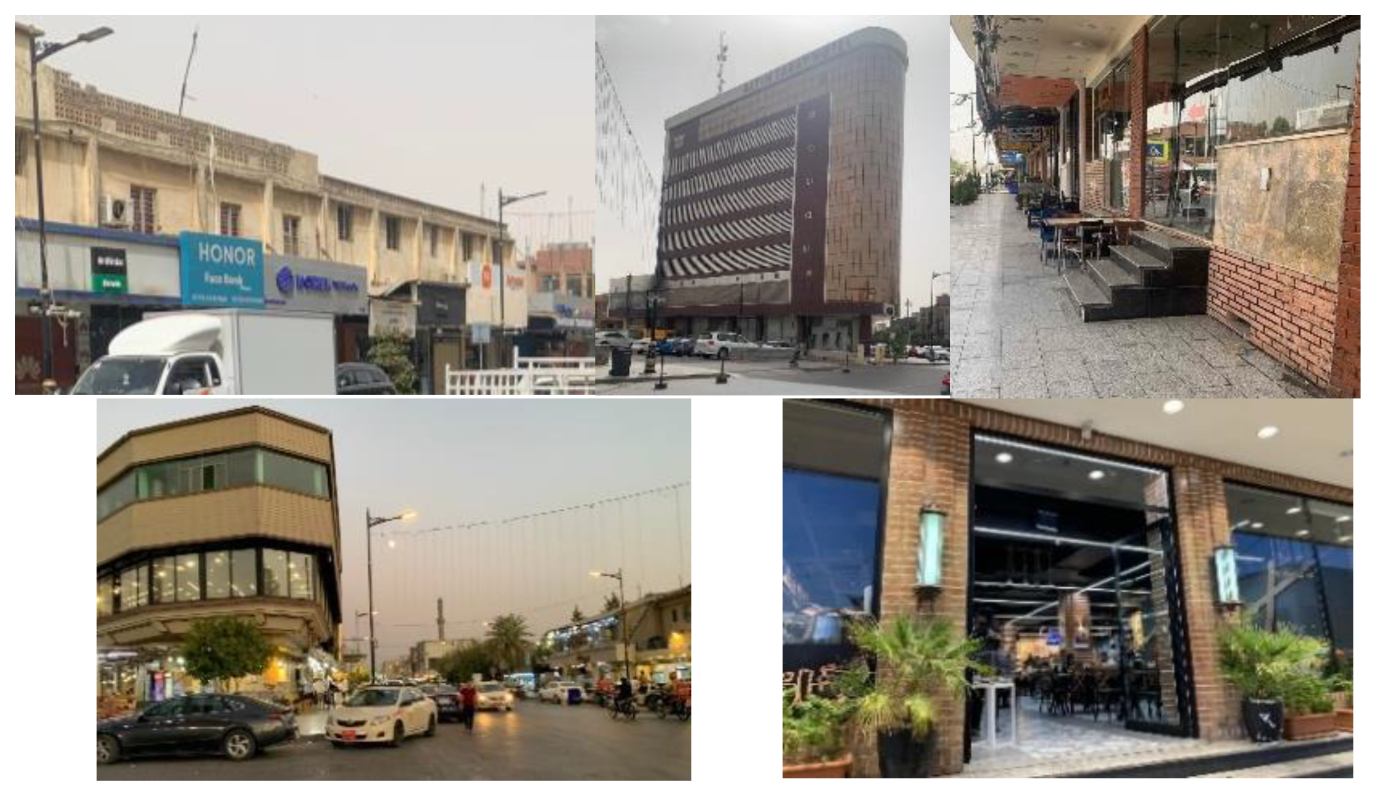
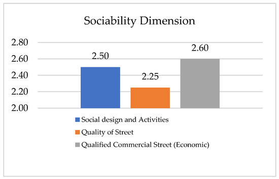
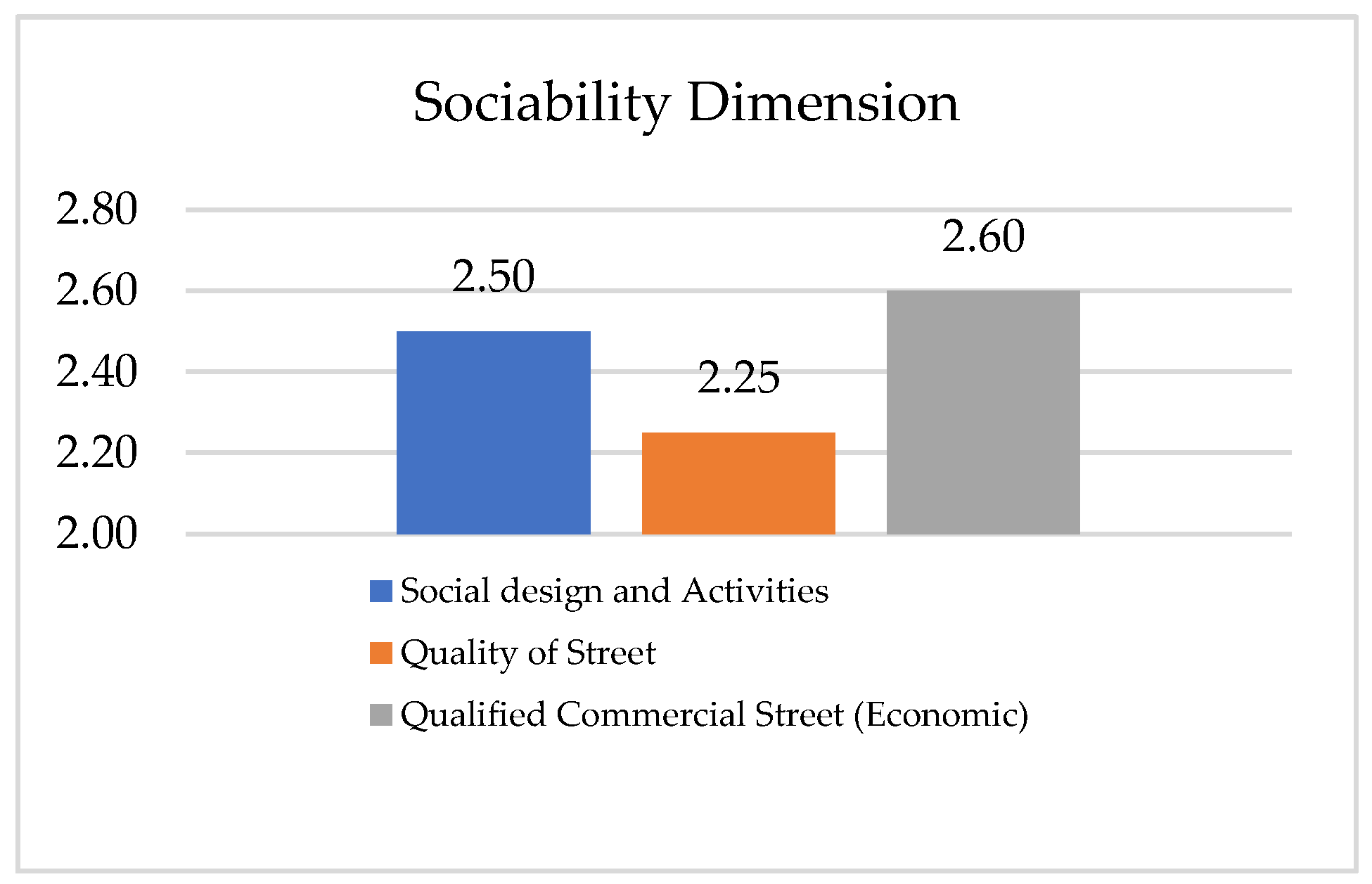
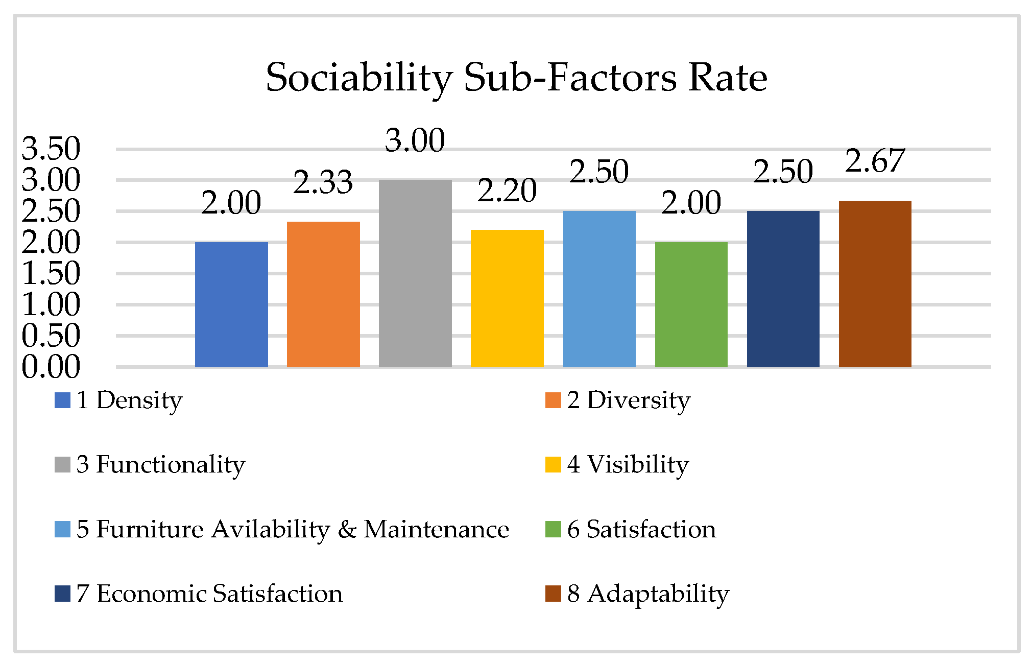
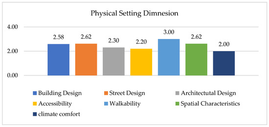
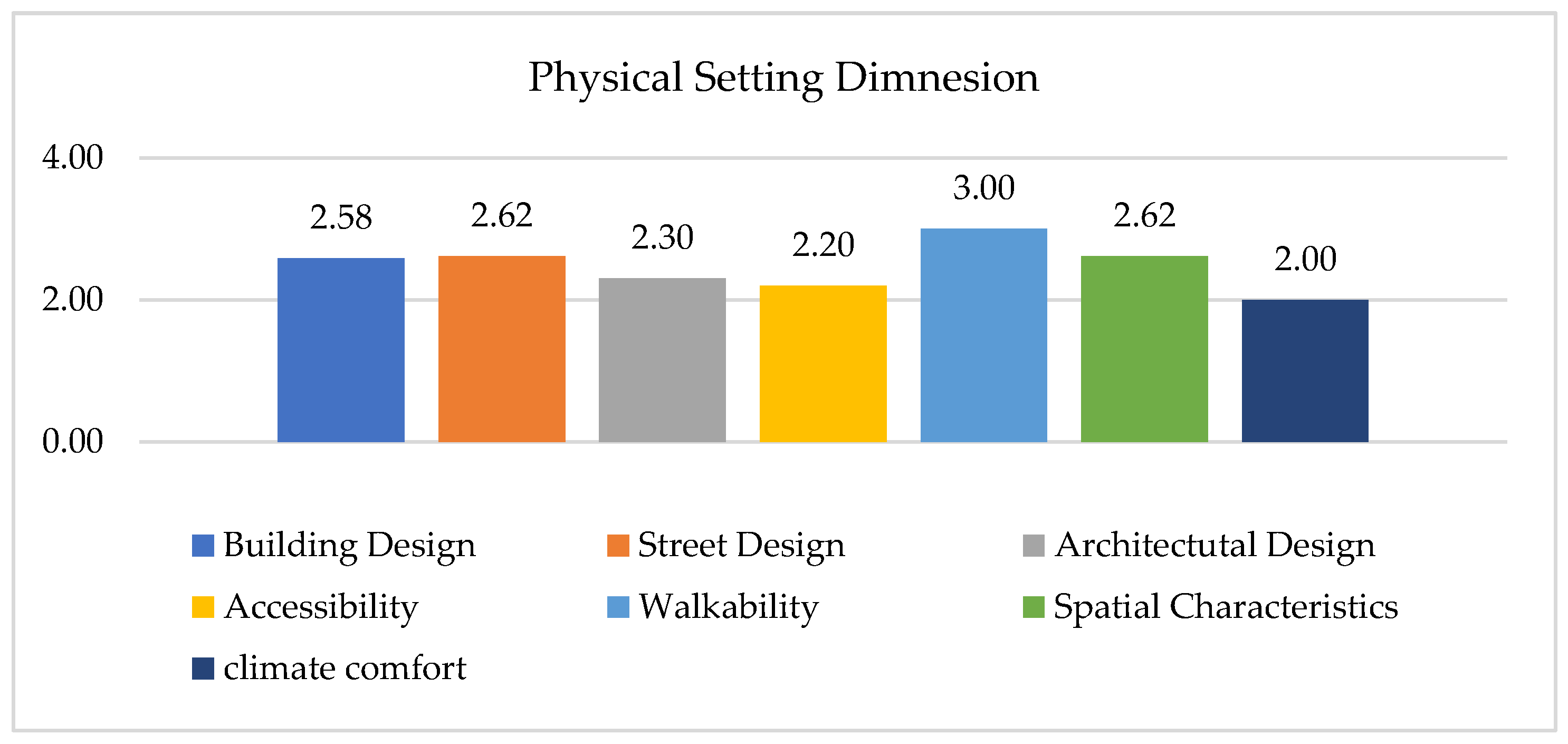
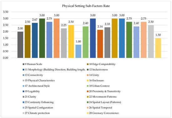
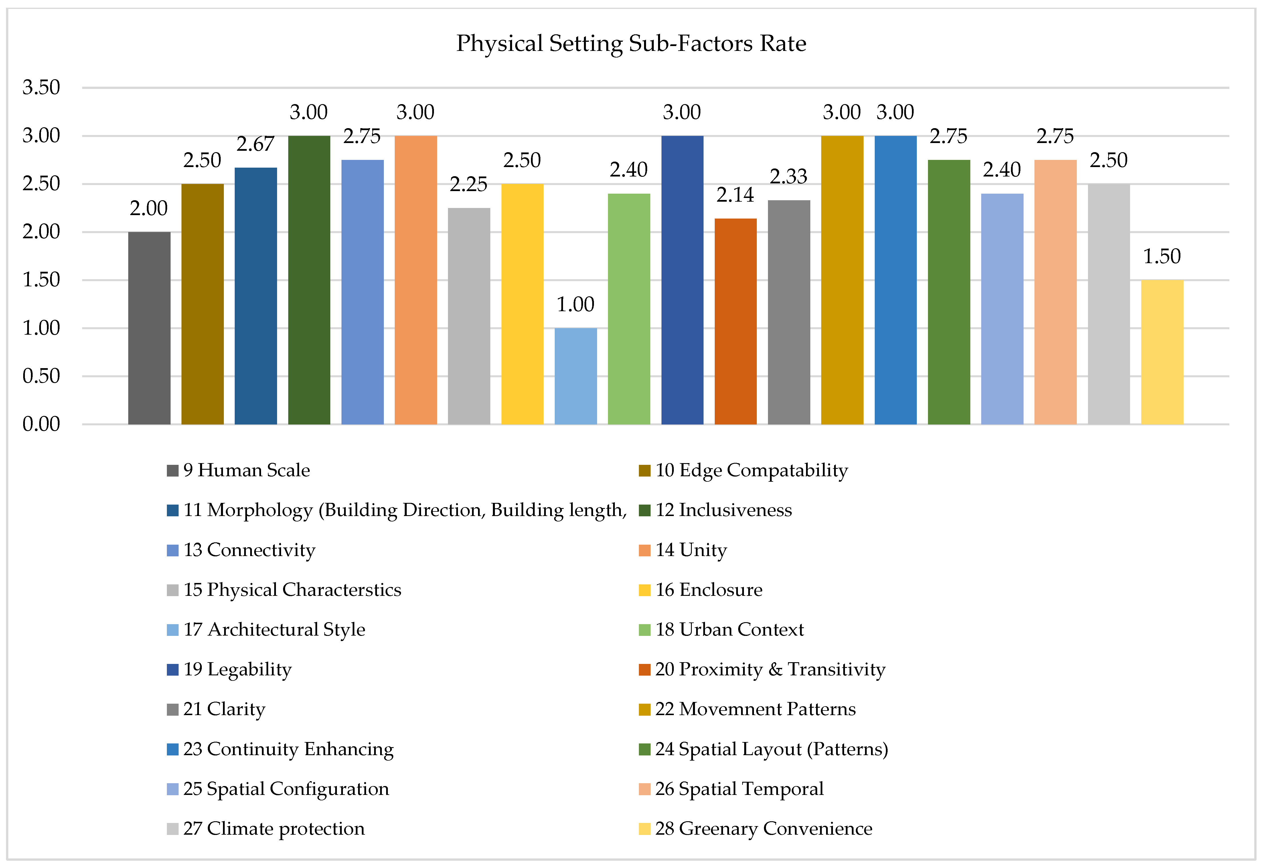
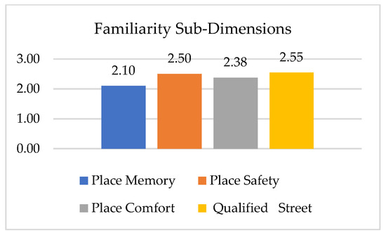
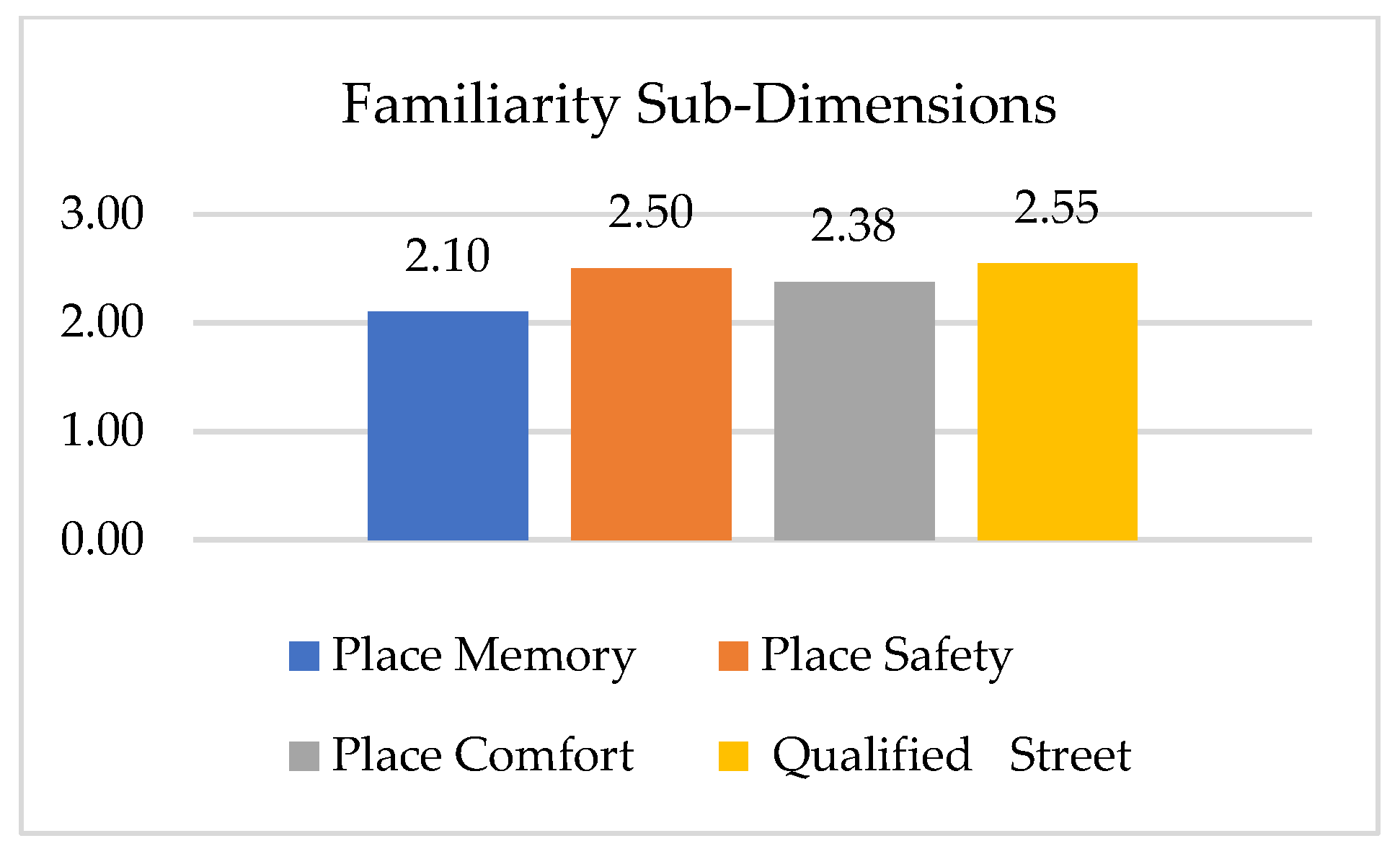
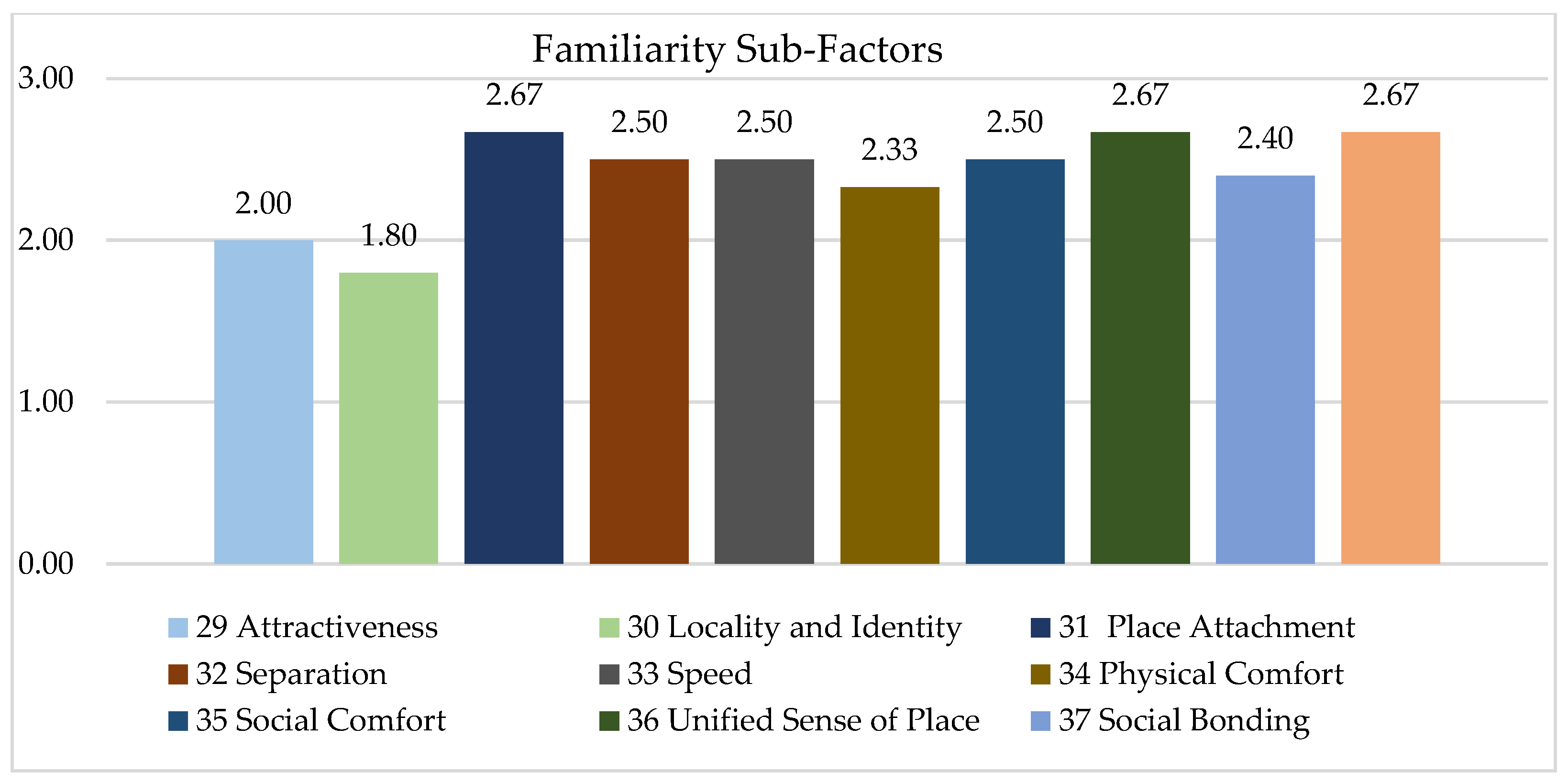
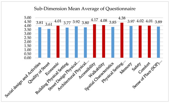
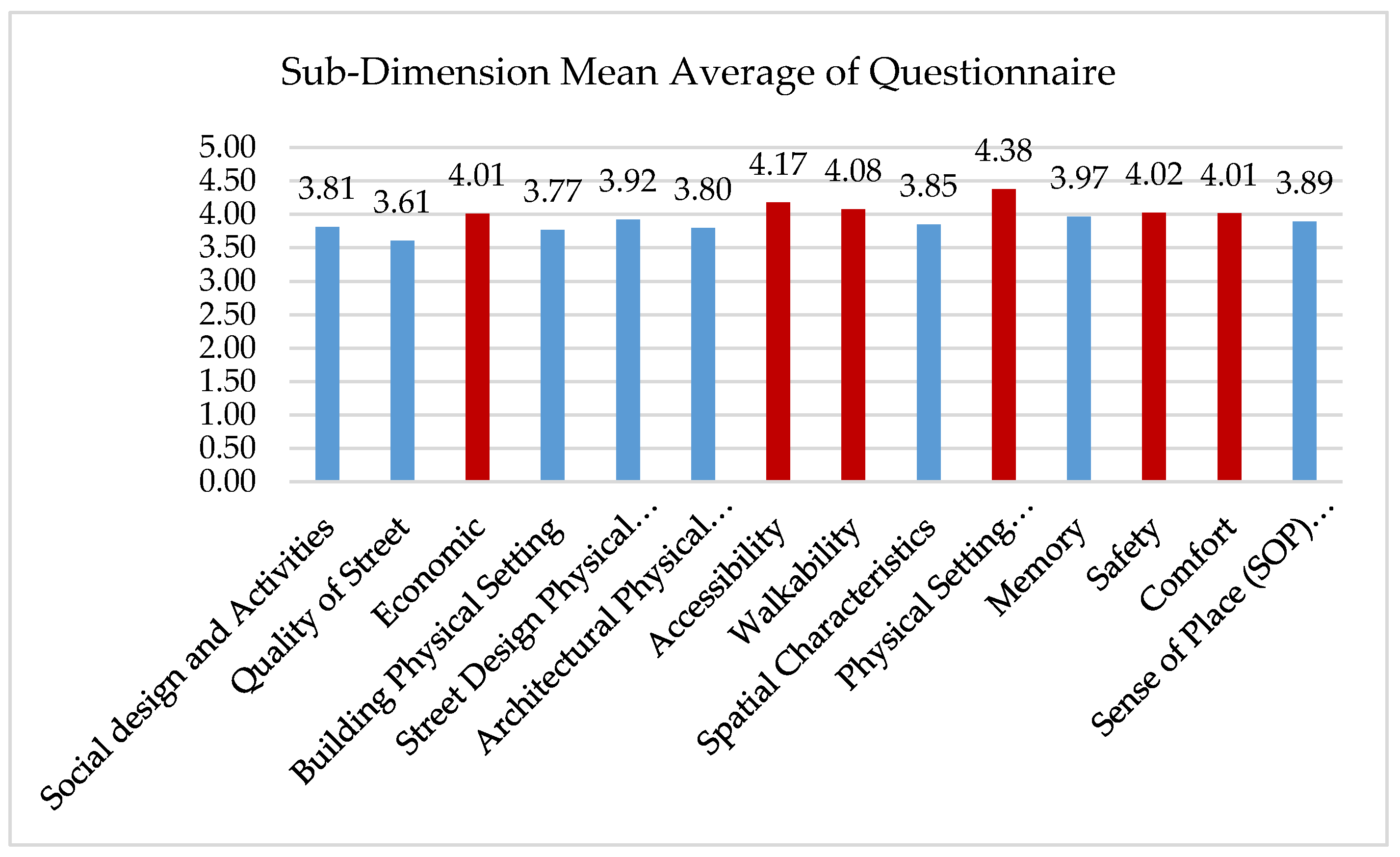
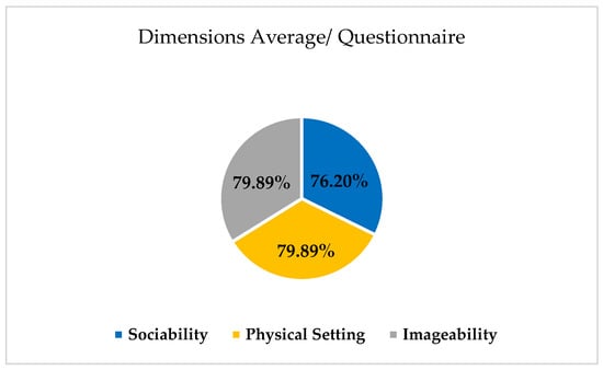
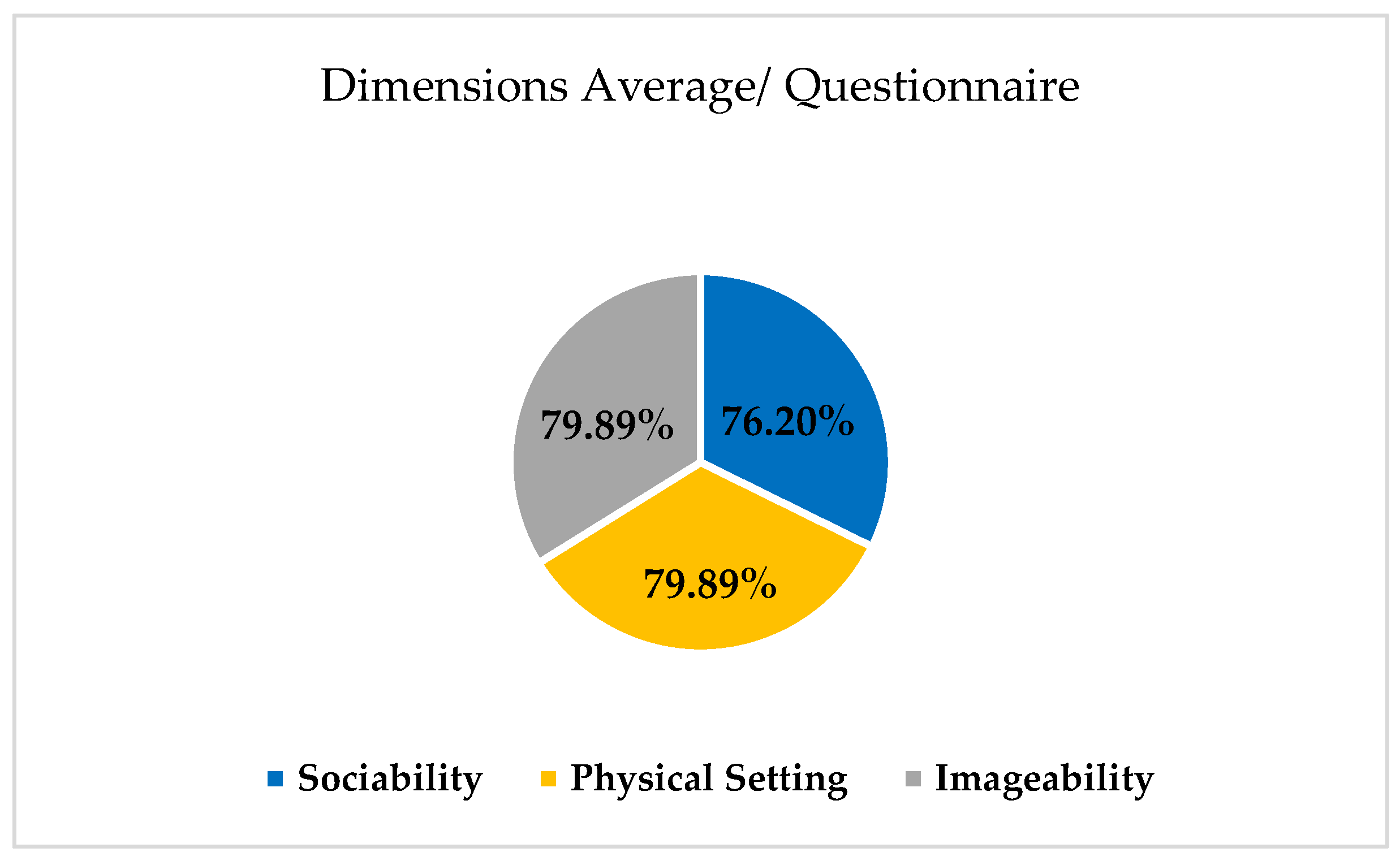
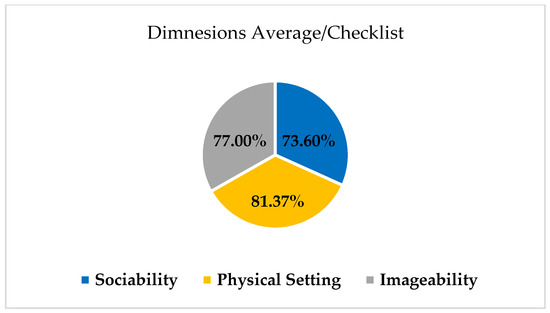
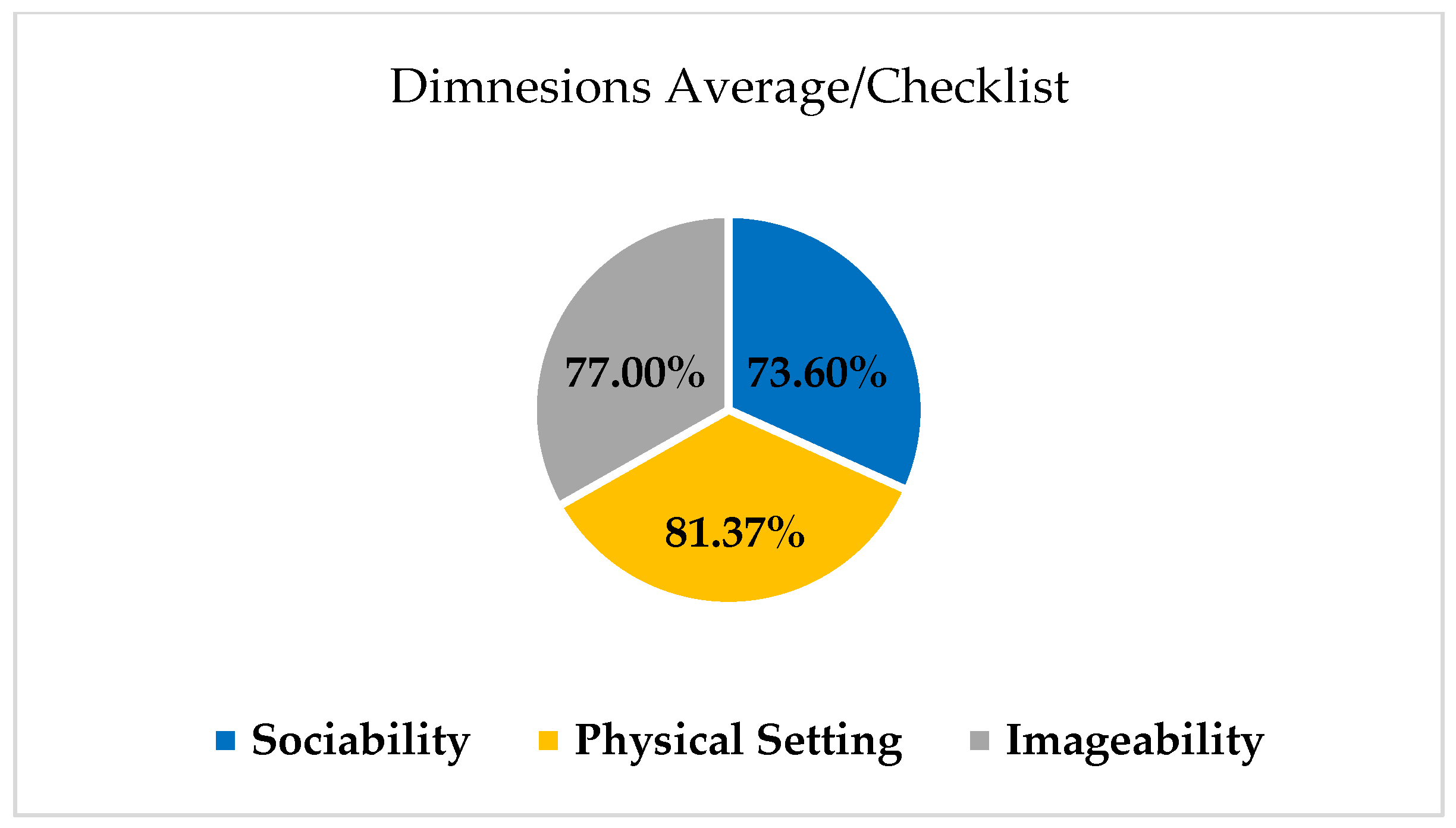
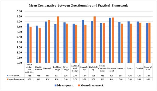
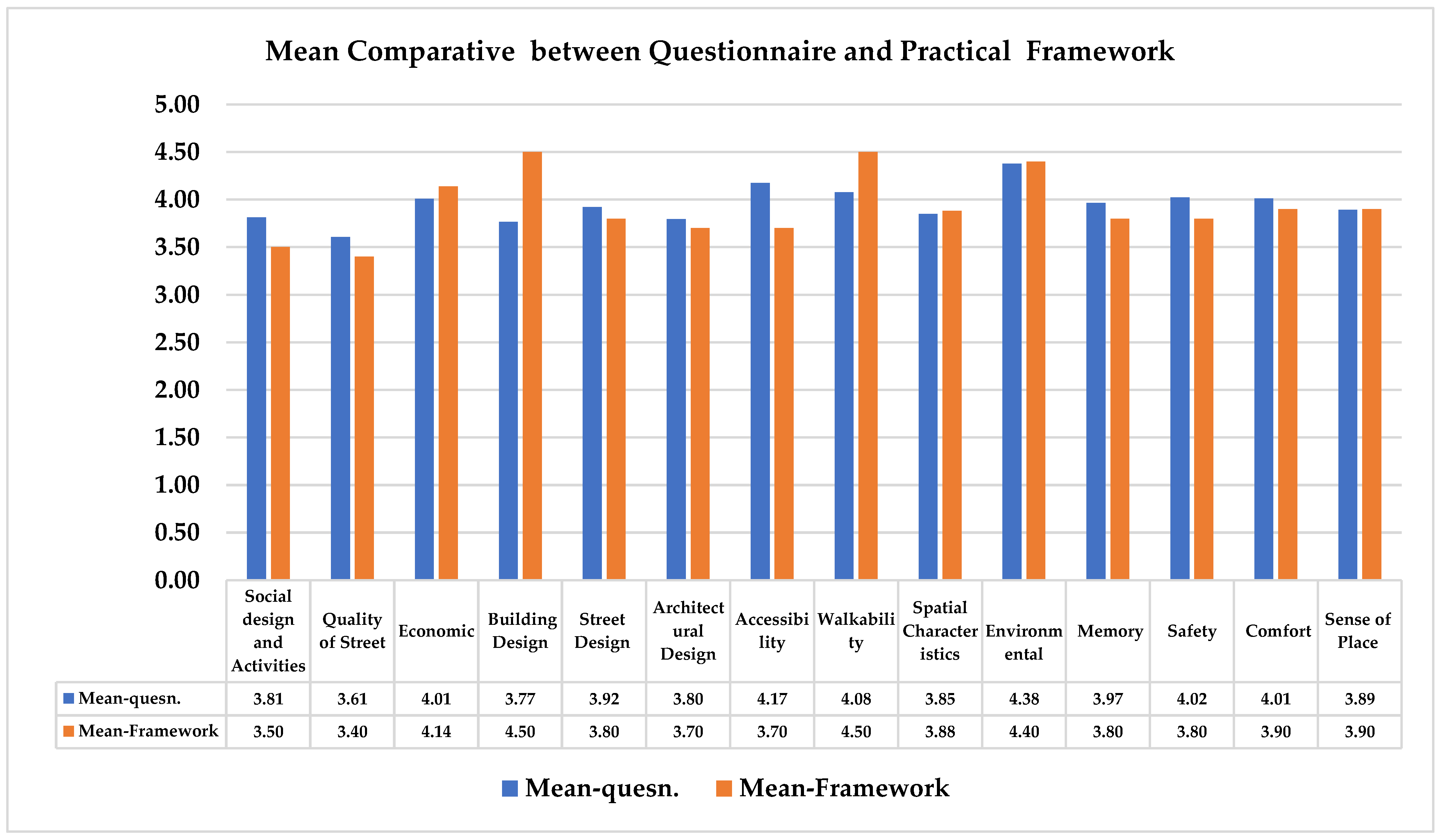
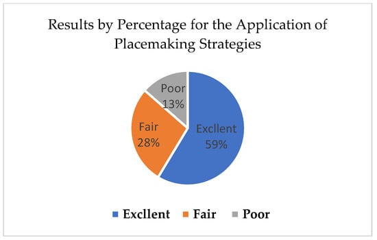
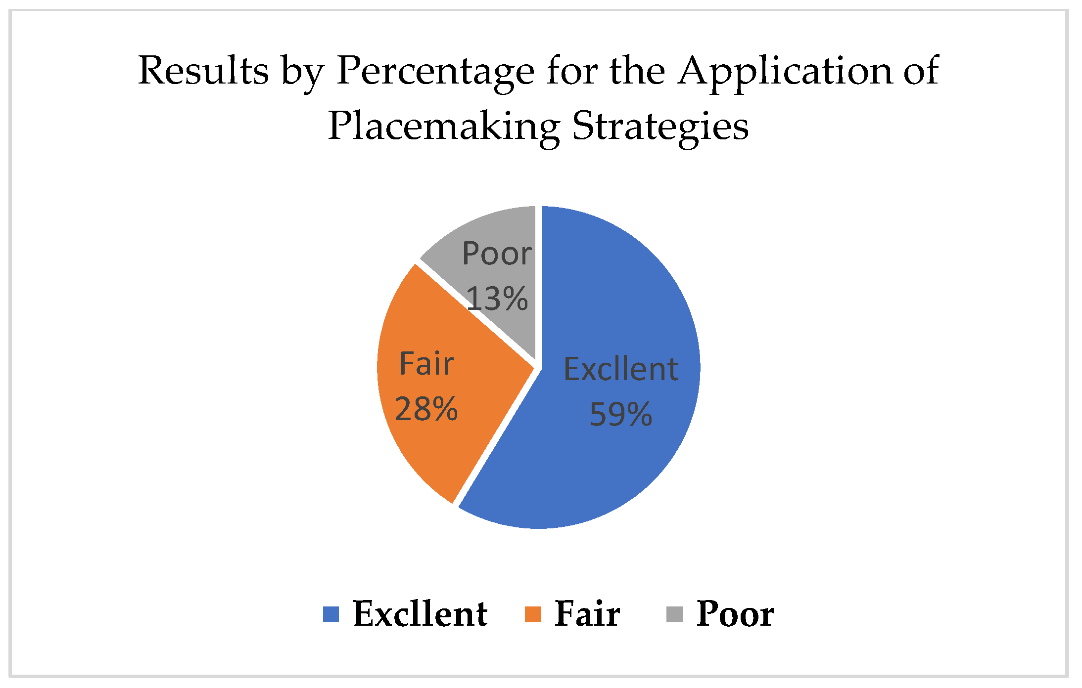
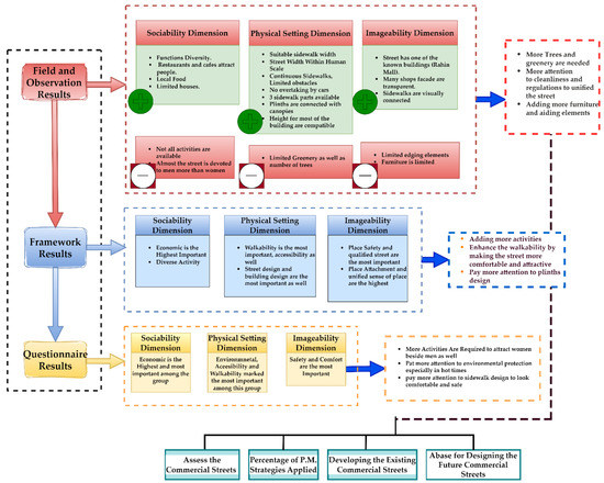
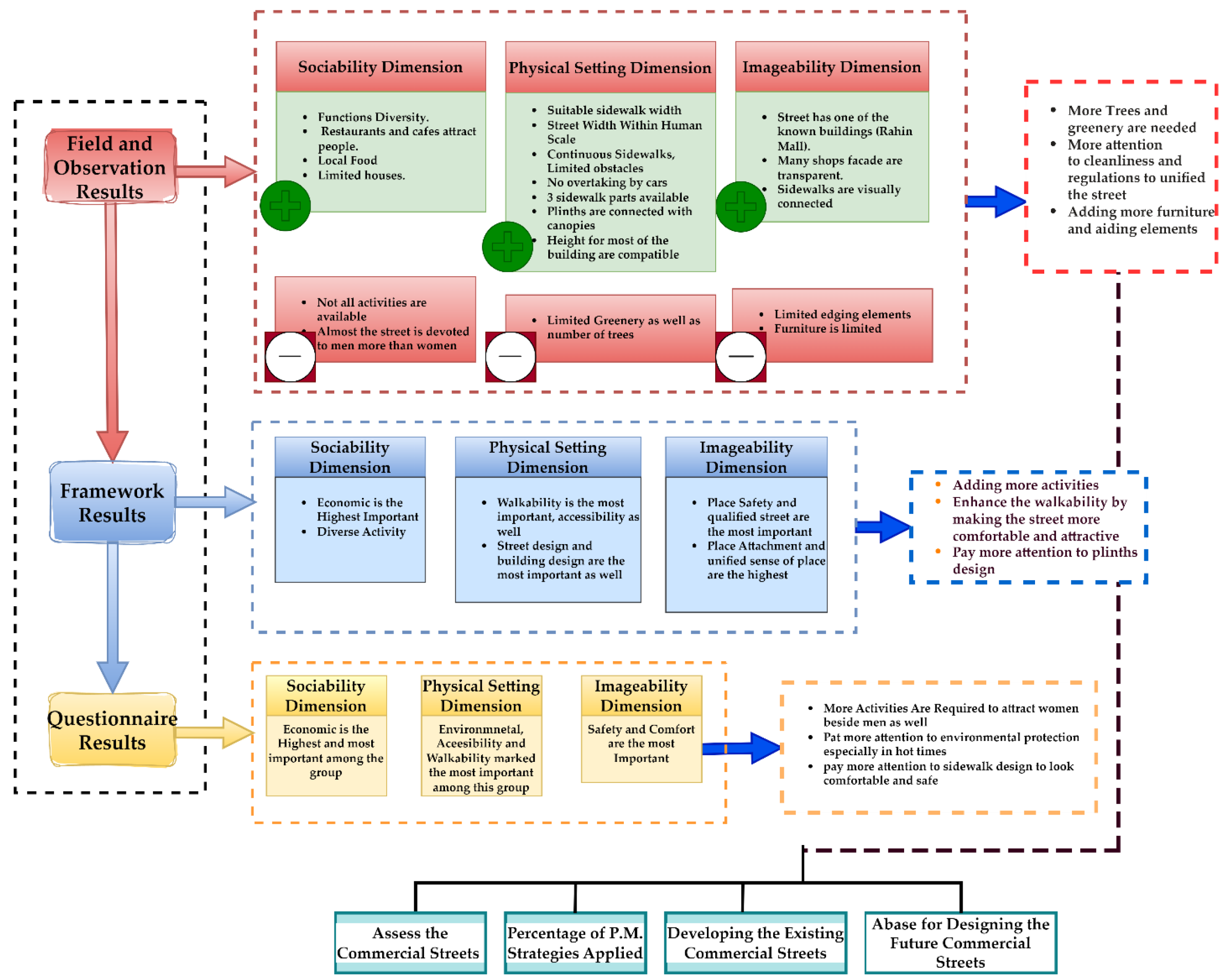

Disclaimer/Publisher’s Note: The statements, opinions and data contained in all publications are solely those of the individual author(s) and contributor(s) and not of MDPI and/or the editor(s). MDPI and/or the editor(s) disclaim responsibility for any injury to people or property resulting from any ideas, methods, instructions or products referred to in the content. |
© 2023 by the authors. Licensee MDPI, Basel, Switzerland. This article is an open access article distributed under the terms and conditions of the Creative Commons Attribution (CC BY) license (https://creativecommons.org/licenses/by/4.0/).