


Abstract
Forest landscape configurations in Mediterranean regions often promote fuel continuity, low structural heterogeneity, and inefficient spatial allocation of fuel treatments, increasing wildfire intensity and spread. This study improves wildfire risk management by applying spatially explicit Integer Linear Programming (ILP) models to optimize fuel-treatment allocation under operational constraints in two Mediterranean case studies: Vale do Sousa, Portugal, and Lesvos Island, Greece. In Portugal, wildfire risk was represented using a stand-level wildfire resistance indicator that accounts for the spatial influence of neighboring stands, whereas in Greece, simulation-derived fire spread probabilities from the FSim fire behavior model were used to prioritize high-risk treatment zones. Despite differences in modelling complexity and data availability, both optimization frameworks generated spatially targeted treatment strategies under contrasting wildfire risk representations. Optimized treatment allocation increased landscape-level wildfire resistance in Portugal from 0.9907 to 0.9959 and reduced expected wildfire risk in Greece from 0.1751 to 0.1701 across increasing treatment-area scenarios. Although these improvements were modest in magnitude, they were consistent across all scenarios. The novelty of this study lies in demonstrating the transferability of an ILP-based optimization framework across contrasting Mediterranean contexts, providing a practical decision-support tool for prioritizing fuel treatments and supporting adaptive, risk-informed forest management.
1. Introduction
Wildfires represent one of the most critical threats to Mediterranean forest ecosystems. In southern European countries, such as Portugal and Greece, the frequency, size, and intensity of wildfires have consistently risen over recent decades [1,2,3]. This trend is closely tied to climate change, fuel accumulation, land abandonment, and fragmented landscape management, all of which contribute to the creation of highly flammable landscapes and greater fire vulnerability [4,5,6].
Despite the pressing need for integrated action, forest and fire management have historically been addressed separately [7,8]. In response, several studies have proposed landscape-level, long-term, strategic interventions aimed at sustaining ecosystem services while reducing wildfire hazard [9,10,11]. Long-term forest management plans typically define treatment schedules, including thinning, harvesting and understory biomass removal, to reshape fuel patterns across the landscape, thereby reducing wildfire spread and severity, while achieving economic goals [9,12]. However, these long-term, multi-period frameworks are primarily designed for strategic forest planning and may not fully support the operational reality in which managers must prioritize and implement short-term actions under practical resource and logistical constraints [13,14]. In practice, fuel treatments are planned under operational constraints to reduce wildfire impacts before fire occurrence [15]. Short-term optimization, therefore, supports the strategic allocation of treatments to achieve immediate wildfire risk reduction while complementing long-term forest management planning [16,17].
Beyond long-term strategic frameworks, several studies demonstrate that spatially targeted fuel treatments planned on an operational, single-period horizon can still deliver substantial reductions in modelled wildfire risk [16,18,19]. Wildfires are a spatially dynamic phenomenon. Their ignition, spread, intensity, and resulting damage are shaped not only by the internal conditions of individual forest stands (e.g., species composition, fuel structure) but also by their spatial relationships with neighboring stands [9,20,21].
Modern forest planning increasingly integrates wildfire risk into decision-support systems (DSSs), combining fire behavior simulation outputs with optimization frameworks. Linear and integer programming methods have proven effective for developing spatially explicit strategies that jointly minimize wildfire risk and economic losses [10,22,23]. Among these, Integer Linear Programming (ILP) is especially valued for its transparency and its ability to analyze multiple ecosystem services and constraints within forest planning [24,25]. Unlike heuristic methods that generally search for satisfactory solutions without guaranteeing optimality, or simulation approaches that evaluate candidate management alternatives, ILP systematically explores the feasible solution space to identify optimal or near-optimal solutions while satisfying model constraints [26,27]. Consequently, it has been extensively applied in forestry for fuel-treatment allocation and harvest planning, as well as in sectors such as logistics, energy systems, and land-use planning [28,29,30,31]. This formulation employs binary decision variables to represent mutually exclusive stand-level management options, while linear constraints ensure that operational requirements, including treatment-area limits, are satisfied, enabling efficient optimization across heterogeneous forest landscapes [25]. Moreover, ILP can explicitly represent trade-offs among competing objectives, including economic efficiency, environmental sustainability, and risk reduction [32,33]. In addition to its technical advantages, government agencies and stakeholders can better understand the consequences of different management scenarios and work towards consensus-driven decisions that are supported by data and analysis [9,34].
Managing forests under increasing wildfire pressure requires the development of indicators that capture the impact of management decisions on fire risk. Ferreira et al. [22] introduced a wildfire resistance indicator that accounts for both the intrinsic fire susceptibility of individual stands and their influence on surrounding areas. This indicator was integrated into an ILP model that was designed to optimize prescriptions to enhance landscape-level fire resilience. Building on this foundation, Marques et al. [32] used it to define wildfire risk criteria for management planning. Ferreira et al. [35] extended the model to address multiple ecosystem services, such as biodiversity, cork production, soil erosion, and economic value, within a multi-period, multi-objective landscape framework. Their approach also incorporated operational constraints, such as adjacency rules for species-specific clearcutting, establishing a robust platform for integrated, fire-smart forest planning.
An additional layer of complexity lies in the integration of fire dynamics in forest management planning. Simulation models provide probabilistic estimates of fire transmission between stands across the landscape, offering dynamic and spatially explicit representations of wildfire risk [18,20,21,36]. Nevertheless, approaches that rely on multiple wildfire behavior simulations have computational shortcomings that derive from the combinatorial features of the landscape design problem [10,37]. This demonstrates the relevance of integrating wildfire simulation-derived metrics into mathematical programming frameworks to enhance landscape design and wildfire risk management [38,39].
This study examines how forest management planning can be structured to mitigate wildfire risk across different ecological regions. We applied an optimization-based decision-support framework to two fire-prone Mediterranean regions, i.e., the Vale do Sousa in Portugal and Lesvos Island in Greece, to evaluate how spatially targeted silvicultural treatments can reduce wildfire risk while addressing constraints on the size of the area that may be treated. Unlike most wildfire optimization studies that rely on a single wildfire risk representation, this study comparatively evaluates indicator-based and simulation-based wildfire risk approaches within a unified optimization framework. The Portugal implementation uses a wildfire resistance indicator, whereas the Greece implementation uses FSim-derived fire spread probabilities. By applying the same optimization framework to two contrasting wildfire risk representations, the study evaluates its flexibility across different ecological conditions, biophysical settings, and data environments. Through this comparative lens, we aim to provide actionable insights for implementing risk-informed forest management strategies that are both context-sensitive and operationally feasible.
2. Materials and Methods
2.1. Case Studies Description
This study applies a spatially explicit optimization framework to integrate forest and wildfire risk management across two Mediterranean landscapes: Vale do Sousa (Portugal) and Lesvos Island (Greece). Both landscapes are representative of Mediterranean fire-prone ecosystems.
2.1.1. Vale Do Sousa
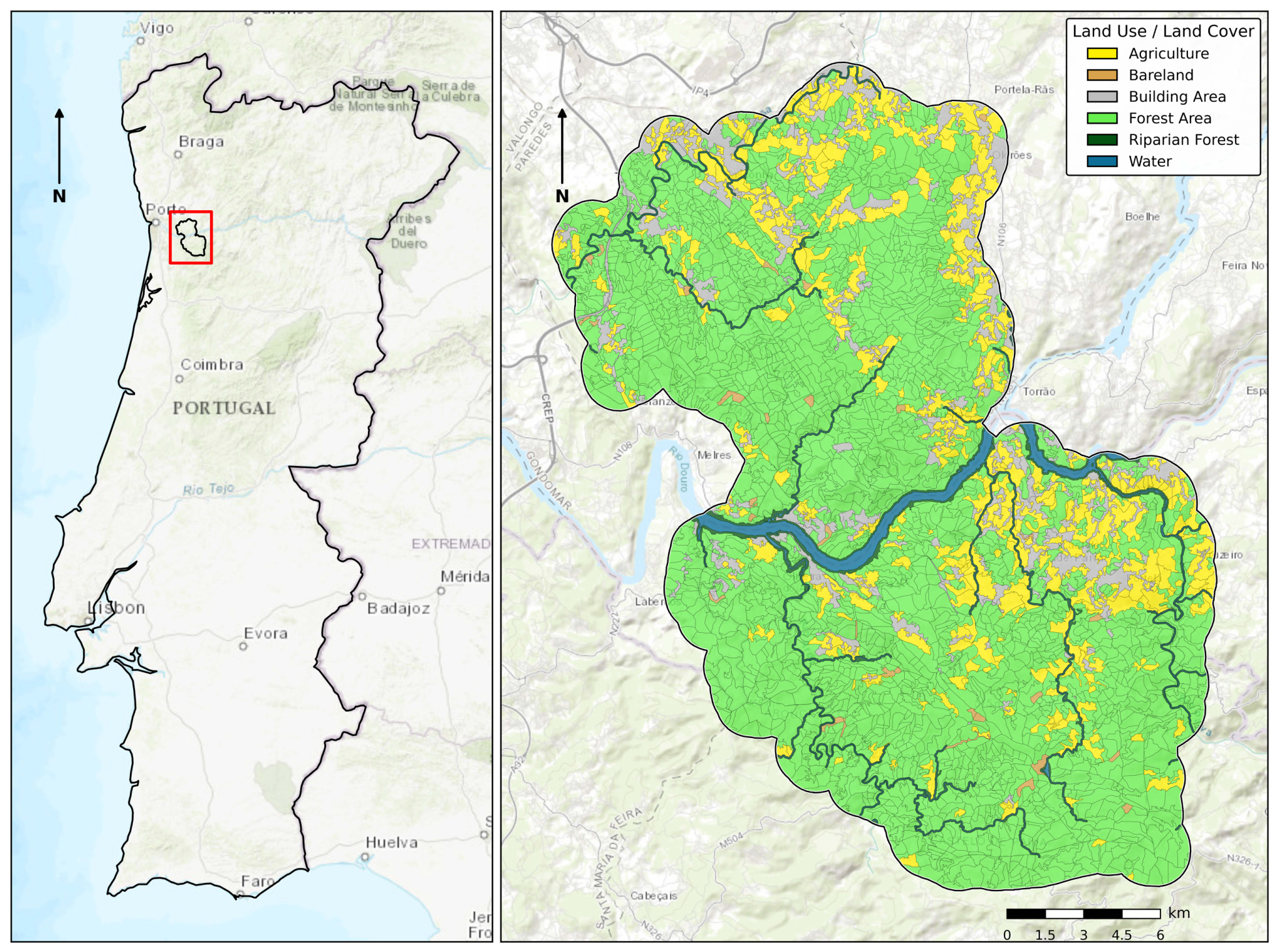
Vale do Sousa, is in the northwestern part of Portugal (Figure 1). It has a Mediterranean climate, characterized by hot, dry summers and mild, wet winters. This forest cover type in the landscape extends over approximately 21,288 ha and was classified into 2572 stands. The forest land cover is predominantly composed of pure eucalyptus stands (Eucalyptus globulus Labill.) and pure maritime pine stands (Pinus pinaster). Only a minor fraction is occupied by hardwood stands of chestnut (Castanea sativa Mill.) and cork oak (Quercus suber L.). Understory vegetation is mainly composed of Erica spp., Cistus ladanifer L., Ulex spp., Adenocarpus angyrophyllus Caball., Rubus fruticosus L., and Quercus lusitanica Lam. Riparian species, such as Alnus glutinosa (L.) Gaertn., Salix atrocinera Brot, Salix alba L., Fraxinus angustifolia Vahl., and Populus nigra L., are present near the Douro River and its confluent rivers and streams.
Due to recent wildfires and clearcuts, 16% of the forest area was classified as bare land or occupied by shrubs. Moreover, in recent years, the region has experienced recurring wildfires, with four of its municipalities being ranked among the twenty Portuguese municipalities with the highest number of fires in 2022 [40].
Figure 1.
Location of the Vale do Sousa study area in mainland Portugal and its land-use/land-cover map [41]. The mapped classes include Agriculture, Bareland, Building Area, Forest Area, Riparian Forest, and Water. The background map is Esri World Topographic accessed via the contextily Python (3.12.10) package, while the land-use/land-cover data and stand boundaries were obtained from the Vale do Sousa spatial database.
2.1.2. Lesvos Island
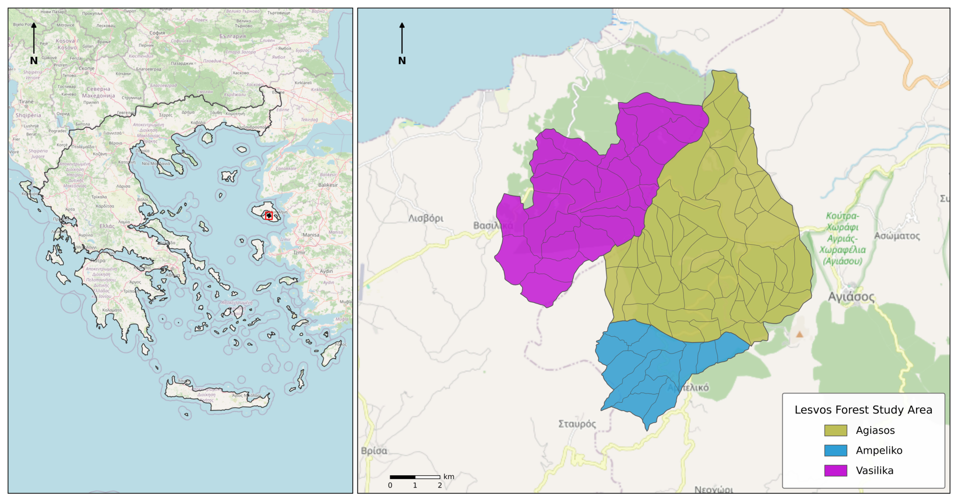
The Greek case study is located on Lesvos Island, North Aegean Region (Figure 2), encompassing three distinct adjacent forest sites with separate management plans: Ampeliko, Agiasos, and Vasilika. Together, these forests were modelled as a single landscape for optimization purposes, covering approximately 6100 ha and comprising 107 forest stands. The vegetation is dominated by Pinus brutia (Calabrian pine), with a significant presence of evergreen broad-leaved species, including Quercus coccifera, Juniperus oxycedrus, Pistacia lentiscus, Arbutus unedo, and others in the forest understory. The topography ranges from coastal to mountainous, with slopes up to 70% and altitude variations between 50 and 900 m.
Figure 2.
Location of the Lesvos Island study area in Greece, showing the three forest areas (Ampeliko, Agiasos, and Vasilika) and their forest stand boundaries with OpenStreetMap as the base layer map accessed via contextily Python (3.12.10) package, while forest stand data were obtained from the forest management database.
The Ampeliko Forest (i.e., 809 ha) consists of 12 stands. Approximately 89% is forested and the terrain features dominant slopes of 40–70%. The area has a history of small fire events, with sparse but accumulated surface fuels. The Agiasos Forest (i.e., 3178 ha), which is part of the Natura 2000 protected network, lies adjacent to the Ampeliko Forest. It is divided into 66 stands and is composed almost entirely of Pinus brutia. The forest has experienced several historical wildfires, including a major event in 1982 that burned over 400 ha. The Vasilika Forest (i.e., 2132 ha), situated on the northwestern slopes of Mount Olympus of Lesvos Island, includes 29 stands. It is composed primarily of Pinus brutia and shows evidence of natural regeneration in areas of historical land abandonment.
2.2. Methods
2.2.1. Resource Capability Models
To effectively evaluate wildfire risk mitigation strategies within the distinct contexts of Portugal and Greece, this study employs multiple scenarios and modelling approaches. In both cases, we employed a Model I binary Integer Linear Programming (ILP) formulation [42], in which the decision variables are binary, to optimize the allocation of silvicultural treatments under operational and legal constraints. Although the core ILP structure remains consistent, the case studies differ fundamentally in how wildfire risk is modelled and incorporated into the objective function.
In the Portugal Living Lab, the wildfire resistance indicator developed by Ferreira et al. [22,35] was integrated into the objective function to account for the impact of management actions on wildfire resilience. The model targets the maximization of that indicator. In contrast, the Greece Living Lab employs a simulation-based approach, modelling fire risk through spread probabilities generated by FSim [43,44]. The optimization, in this case, sought to minimize expected fire risk by prioritizing thinning interventions in high-risk zones. The two study areas differ in their biophysical characteristics, environmental conditions, and wildfire risk representation. The 10%, 20%, and 30% treated-area scenarios were selected to reflect progressively increasing management interventions within the 5%–30% thinning range commonly implemented in Greek forests [41].
In each stand i, where S is the set of all stands in the landscape, the model assigns a single management option j from a predefined set of treatment options () available for that stand. In the case of Vale do Sousa, the listed options include clearcutting, thinning, shrub cleaning, or do nothing, whereas for Lesvos Island, treatments are either thinning or do nothing. Thus, both resource capability models include decision variables, , which define whether stand i is assigned to treatment j. In both cases, the variables are binary:
Each stand must be assigned one and only one option:
Equation (1) ensures that either a treatment or the do-nothing option is selected to manage each stand in the landscape.
The set of admissible treatment options , in Vale do Sousa, is stand-specific and depends on species composition, stand structure, and age. Consequently, not all stands can be assigned all treatments in the planning period. All 2572 stands in the landscape had at least two available treatment options (do nothing and shrub cleaning), enabling the optimization model to allocate shrub-cleaning treatments across the area. In contrast, species-specific silvicultural regimes constrained thinning, coppice harvest, and clearcutting. The former was available in the case of 25 stands, while the latter was available in 165 and 215 stands, respectively.
Moreover, both models include constraints on the area assigned to treatment options (Equation (2)):
In both case studies, an ILP solution approach was used to explore the resource capability models and find the allocation of management options that either maximize fire resistance (Vale do Sousa) or minimize expected fire risk (Lesvos Island). Although both rely on the same optimization technique, they differ fundamentally in how fire risk is represented and incorporated into the planning process. The Portugal case study was solved using IBM ILOG CPLEX Interactive Optimizer version 12.6.3.0 (IBM Corp., Armonk, NY, USA), whereas the Greece case study was solved using the PuLP optimization library in Python version 3.12.10 (Python Software Foundation, Beaverton, OR, USA) with the open-source COIN-OR CBC solver. The Portugal model involved a larger and more computationally demanding optimization problem, making CPLEX a suitable choice for its computational efficiency in solving large-scale ILP formulations. In contrast, the Greece model was smaller and was solved efficiently using the CBC solver through the PuLP interface. Both solvers reached optimal solutions for their respective formulations; therefore, the choice of solver does not affect the optimization results, although computational performance may differ.
Vale Do Sousa
This ILP model aims to assign management options prior to the wildfire season. Wildfire risk mitigation in the Vale do Sousa landscape is addressed by maximizing the landscape-level resistance indicator with Equation (3). The wildfire resistance indicator integrates wildfire occurrence probability, wildfire damage probability, and the spatial relationships among neighboring stands into a composite index representing the capacity of a stand to resist wildfire spread. Consequently, it captures both stand-level flammability and the influence of landscape configuration on wildfire behavior [22]:
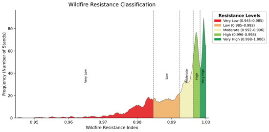
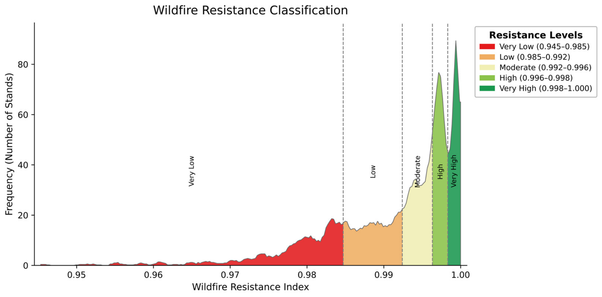
The distribution of the wildfire resistance index values across the stands (Figure 3) was used to define five resistance classes (Very Low, Low, Moderate, High, and Very High) using percentile-based thresholds (20th, 40th, 60th, and 80th percentiles). These thresholds were calculated once from the baseline (before-treatment) wildfire resistance values and then applied unchanged to all treatment scenarios, ensuring direct comparison of resistance classes across scenarios.
Figure 3.
Frequency distribution and classification of the wildfire resistance index for the baseline scenario in Vale do Sousa, Portugal. The wildfire resistance index ranges from lower resistance (red) to higher resistance (green). The five resistance classes (Very Low, Low, Moderate, High, and Very High) were defined using percentile thresholds derived from the baseline (before treatment) distribution.
Lesvos Island
Wildfire risk estimates () for the Lesvos case study were derived from a previously developed stochastic FSim simulation dataset [44], which denotes the fire risk in stand i before treatment. The dataset incorporates landscape-specific fuel characteristics, topography, weather conditions derived from ERA5-Land, and probabilistic fire behavior simulations based on the Minimum Travel Time algorithm, providing spatially explicit estimates of wildfire transmission and burn probability for operational planning.
To address fire risk mitigation on the Lesvos Island landscape, we formulated an ILP model with the objective of minimizing the expected fire risk with Equation (4):
For each stand , post-treatment fire risk depends on the selected option . If thinning is applied, fire risk is reduced by 5%, whereas if no treatment is applied, fire risk increases by 1%. Following previous studies demonstrating that thinning reduces wildfire intensity and crown fire potential, while untreated stands experience gradual fuel accumulation [7,45], thinning was assumed to reduce wildfire risk by 5%, whereas untreated stands were assumed to experience a 1% increase in wildfire risk. These values provide a simplified representation of treatment effects suitable for short-term operational planning:
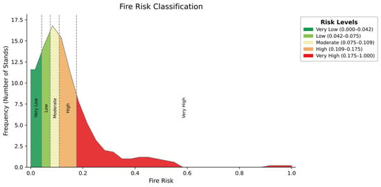
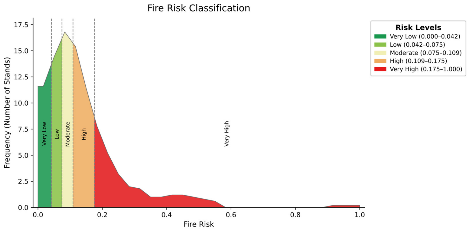
The distribution of the fire risk index in 2026 across the stands (Figure 4) led to the classification of risk levels (Very Low, Low, Moderate, High, and Very High) using percentile thresholds (20th, 40th, 60th, and 80th percentiles) based on the distribution of the normalized fire risk values before treatment.
Figure 4.
Frequency distribution and classification of the FSim-derived fire risk index for the baseline (before treatment) scenario in Lesvos Island, Greece. The colored areas represent the five fire risk classes (Very Low, Low, Moderate, High, and Very High) defined using percentile-based thresholds calculated from the baseline distribution.
3. Results
3.1. Addressing Wildfire Risk in Vale Do Sousa
The landscape-level wildfire resistance increased slightly as the allowable area for active treatments expanded (Table 1). Relative to the no-treatment baseline (0.9907), wildfire resistance increased to 0.9934 when 10% of the area was treated and continued to rise to 0.9949 and 0.9959 under the 20% and 30% treatment scenarios, respectively. These results indicate that improvements in wildfire resistance can be achieved through relatively limited spatial intervention, while additional gains exhibit diminishing marginal returns as treatment coverage increases. Although the optimized resistance values remain within the ‘moderate’ resistance class across all scenarios, the increase from 0.9907 to 0.9959 corresponds to an approximate 0.52% relative improvement. Nevertheless, the optimization consistently improved the indicator and produced a substantial redistribution of stands from lower to higher resistance classes, indicating enhanced landscape resilience despite no change in the overall landscape-level resistance category (Table 1 and Table 2).
Table 1.
Summary of optimized silvicultural treatments by area and number of stands in Vale do Sousa.
Table 2.
Distribution of stands across wildfire resistance classes under different area constraints in Vale do Sousa.
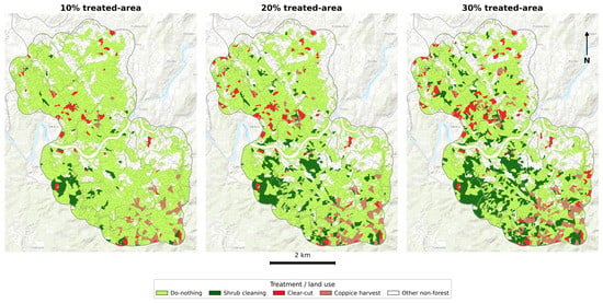
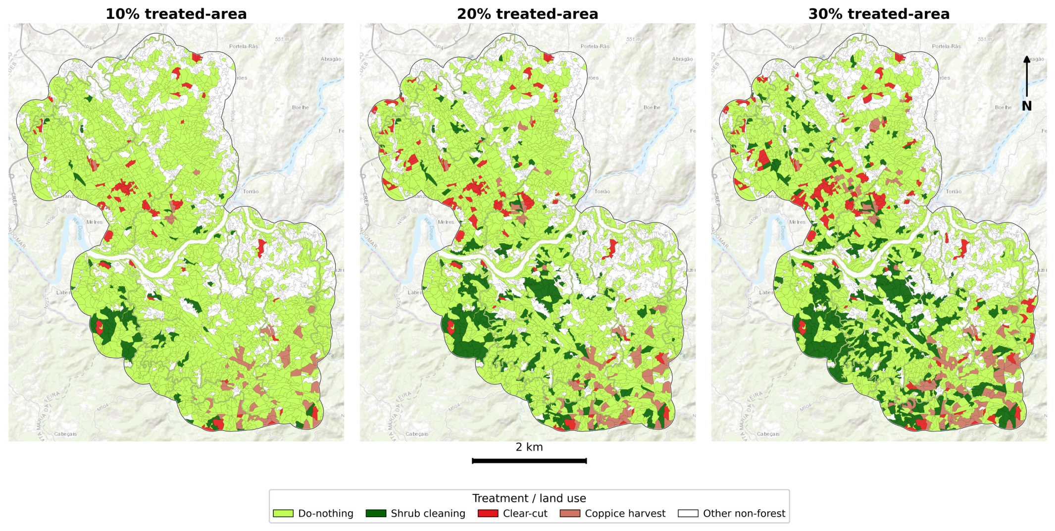
Across all scenarios, the imposed area constraints strongly limited the allocation of treatments, resulting in the do-nothing option dominating both in terms of the number of stands and in terms of its total area (Table 1). As the allowable proportion of treated area increased from 10% to 30%, the number of stands assigned to the do-nothing option declined, reflecting the progressive reallocation of selected stands to be treated (Figure 5).
Figure 5.
Spatial allocation of optimal forest management treatments under 10%, 20%, and 30% treated-area scenarios in the Vale do Sousa study area. Treatments were selected using the Integer Linear Programming optimization model to maximize landscape wildfire resistance while satisfying the corresponding treated-area constraint. The underlying basemap is Esri World Topographic Map accessed via the contextily Python (3.12.10) package.
Under the 10% treated-area constraint, clearcut was applied to 62 stands (560 ha), increasing to 96 stands (852 ha) under the 20% scenario and 135 stands (1218 ha) under the 30% scenario. Similarly, coppice harvest (primarily in eucalyptus stands) contributed to the optimal solutions, being selected in 54 stands (733 ha) at 10%, 82 stands (999 ha) at 20%, and 112 stands (1330 ha) at 30%.
In contrast, shrub cleaning emerged as the dominant active treatment across all scenarios. Under the 10% constraint, shrub cleaning was applied to 79 stands, covering approximately 836 ha. This increased to 258 stands (2406 ha) under the 20% constraint and further expanded to 414 stands (3837 ha) under the 30% constraint. Its dominance is driven by widespread availability and cumulative landscape-scale effectiveness rather than stand-level performance. Conversely, thinning was not selected in any scenario, indicating that it does not provide sufficient marginal gains in wildfire resistance relative to other available treatments under the optimization framework.
When considering only the treated portion of the landscape, shrub cleaning consistently accounted for the largest share of interventions. Under the 10% constraint, shrub cleaning represented approximately 39.2% of the treated area, while clearcut accounted for 26.2%, and coppice harvest accounted for 34.6%, with thinning contributing 0%. Under the 20% scenario, shrub cleaning accounted for approximately 56.5% of the treated area, with clearcut contributing 20.0% and coppice harvest 23.5%. At the 30% constraint, shrub cleaning further increased to approximately 60.2% of the treated area, while clearcut contributed 19.1%, coppice harvest 20.7%, and thinning remained absent.
As the model maximizes area-weighted landscape resistance under a constraint on the total treated area, treatment selection is driven by incremental gains relative to the do-nothing scenario rather than absolute resistance values. Clearcut and coppice harvest were feasible only in a subset of stands, due to species-specific and operational constraints, while thinning was available for only 25 of the 2572 stands and did not provide sufficient incremental gains in the wildfire resistance indicator to be selected under the optimization framework. Consequently, shrub cleaning accounted for the largest proportion of treated areas across all scenarios. Thus, the model prioritizes treatments that deliver the greatest cumulative resistance gain across the landscape, leading to the dominance of shrub cleaning due to its scalability and consistent effectiveness.
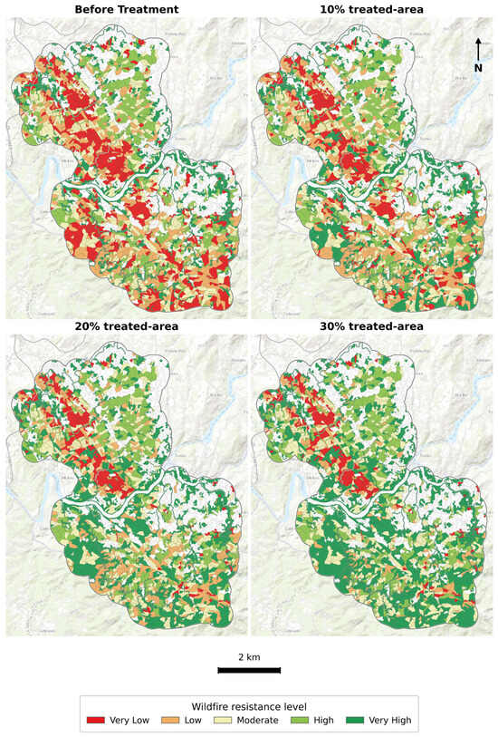
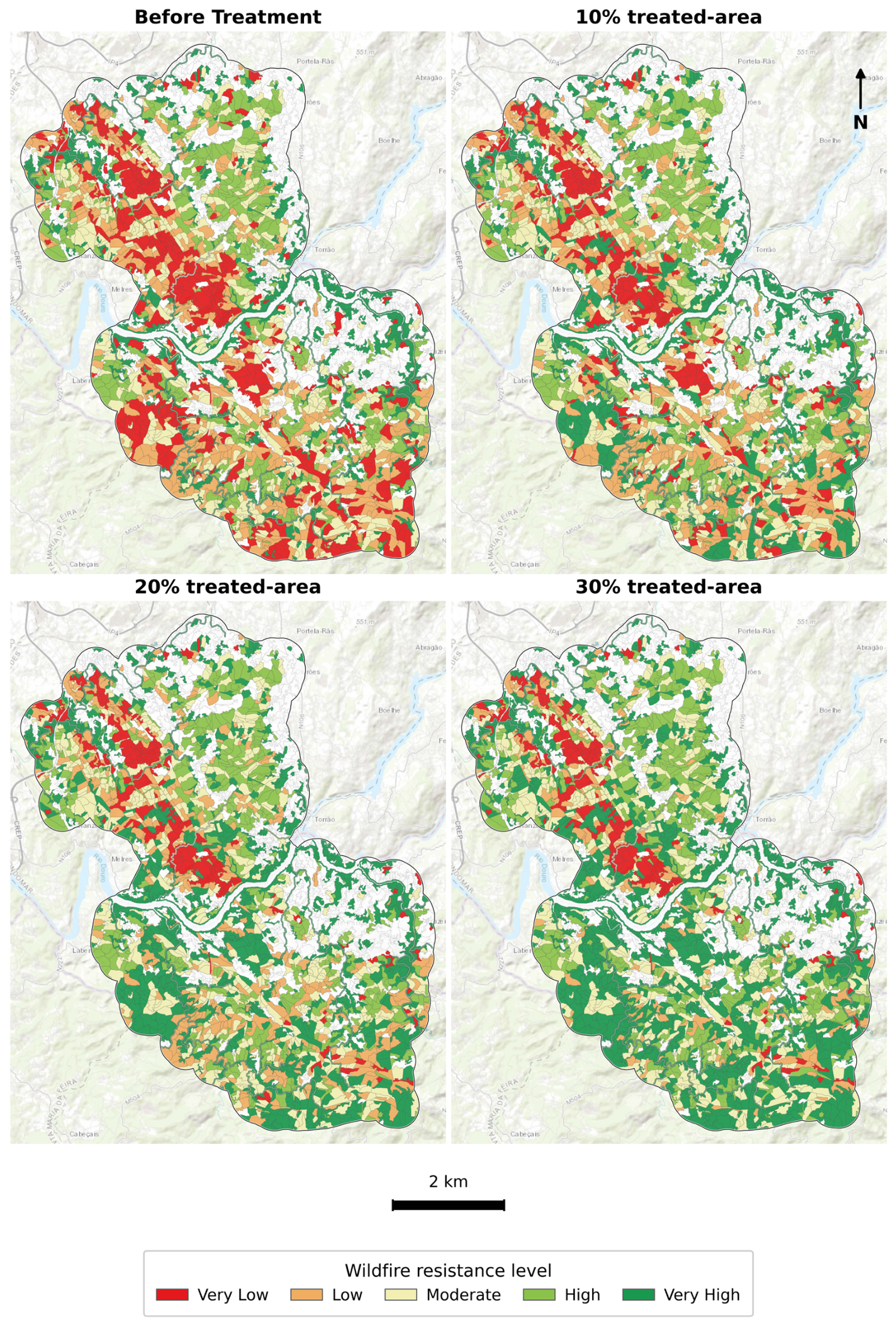
Furthermore, stand-level resistance shows a consistent upward shift with increasing treatment areas (Table 2). As treatment intensity increased from 10% to 30%, the number of stands in the Very Low resistance class decreased substantially (from 515 in the baseline to 320 at 10%, 193 at 20%, and 187 at 30%). At the same time, the number of stands in the Very High resistance class increased markedly (from 515 in the baseline to 696, 912, and 1110, respectively). In contrast, the Low resistance class decreased progressively with increasing treatment intensity (Figure 6).
Figure 6.
Spatial distribution of stand-level wildfire resistance classes before treatment and under the 10%, 20%, and 30% treated-area scenarios in Vale do Sousa, Portugal. Resistance classes were defined using the baseline percentile thresholds and applied unchanged to all post-treatment scenarios. Red indicates Very Low resistance, orange: Low, pale yellow: Moderate, light green: High, and dark green: Very High wildfire resistance. The background map is Esri World Topographic Map (accessed via the contextily Python (3.12.10) package).
Overall, these changes indicate a systematic shift of stands from lower resistance classes toward higher resistance classes as the treatment area expands. When only 30% of the landscape (6385 ha) was actively treated, the number of stands in the Very High resistance class increased by 595, demonstrating that relatively limited interventions can substantially improve the spatial distribution of wildfire resistance across the landscape (Table 2).
3.2. Addressing Wildfire Risk in Lesvos Island
Increasing the proportion of the landscape treated was associated with both a reduction in fire risk and changes in the number and size of selected stands (Table 3). When 10% of the landscape was treated, the area-weighted average fire risk declined from 0.1751 to 0.1734. Increasing the treated proportion to 20% and 30% resulted in further reductions to 0.1714 and, 0.1701, respectively. Across all scenarios, selected stands were concentrated in the high and very high percentile classes ( ≥ 0.1332).
Table 3.
Stand selected under three treatment intensities in Lesvos Island.
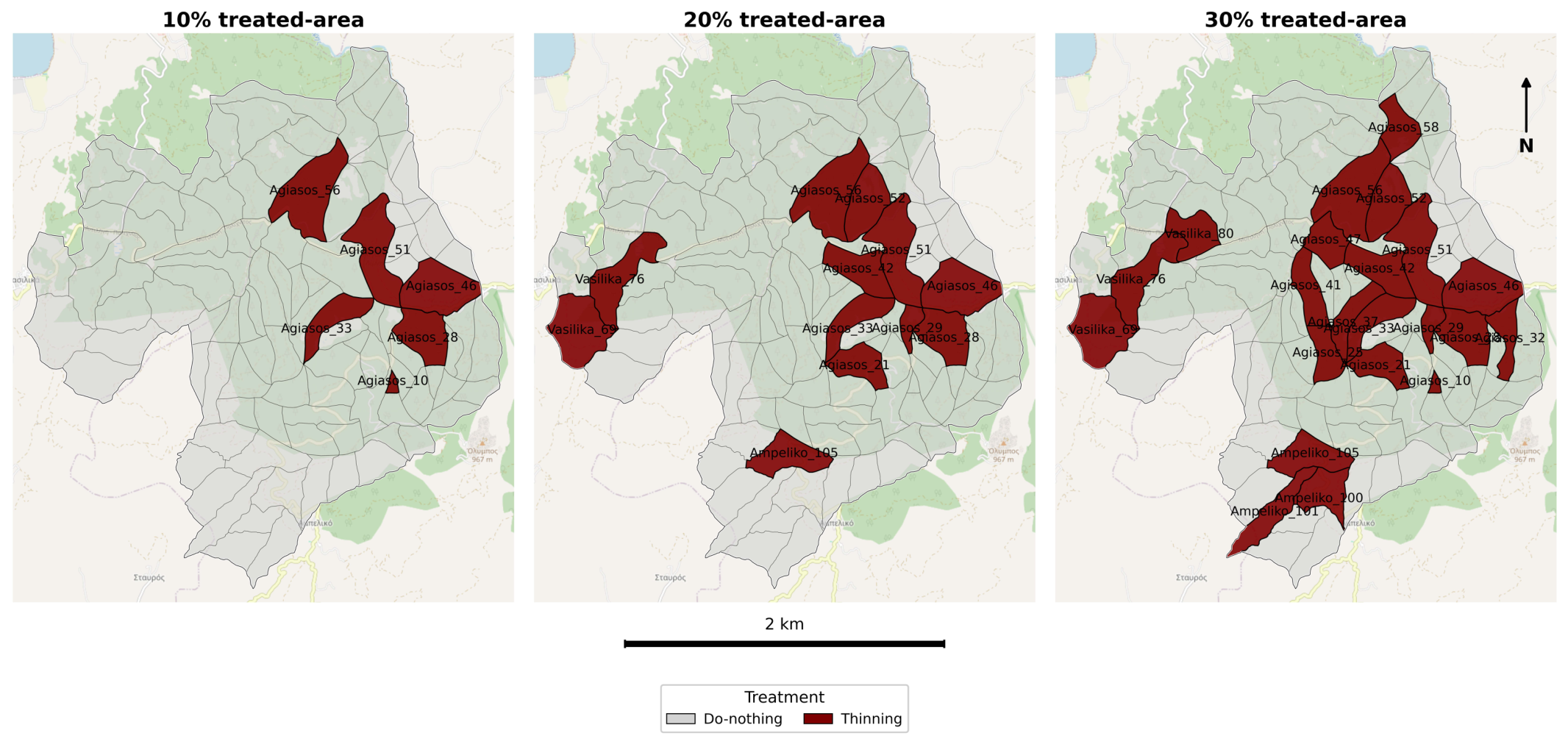
Under the 10% treatment scenario, the model selected six stands, corresponding to a total treated area of approximately 612 ha (out of about 6148 ha total landscape area). The selected stands were predominantly large, with individual stand sizes ranging from approximately 7 to 164 ha, and fire risk values ranging from 0.04 to 1. These stands represent the largest contributors to landscape-level fire risk due to their substantial spatial extent combined with moderate to high fire risk intensity.
When the treated proportion increased to 20% of the landscape, the number of treated stands increased to 12, with a total treated area of about 1229 ha. In addition to the large stands selected under the 10% scenario, the model incorporated medium-sized stands, reflecting the inclusion of the next most influential contributors to landscape fire risk.
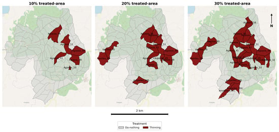
At the 30% treatment level, the model selected 22 stands, corresponding to a treated area of roughly 1843 ha. This scenario included a broader range of stand sizes, from large to smaller plots, and fire risk values spanning moderate to high levels (Figure 7).
Figure 7.
Spatial allocation of management options under different (10%, 20%, 30%) treated-area constraints in Lesvos Island. The underlying OpenStreetMap basemap is provided for geographic reference.
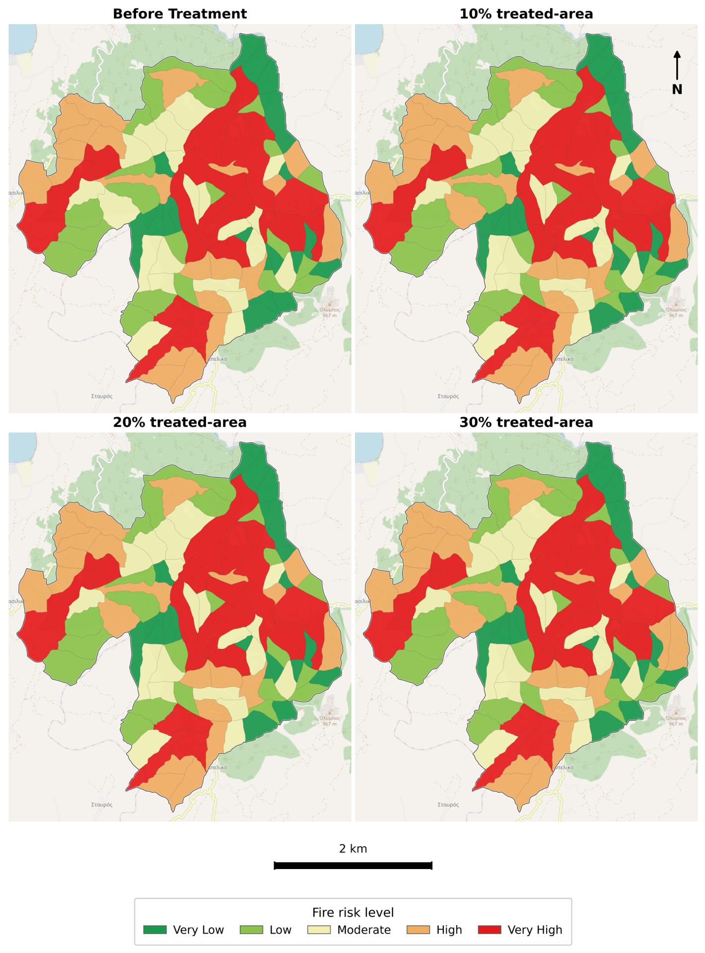
In contrast to the Portugal case study, the distribution of stands across fire risk classes in Greece shows only minor changes under increasing treatment area scenarios (Table 4). Under the 10%, 20%, and 30% treatment scenarios, only slight shifts between neighboring risk classes were observed, with the number of stands in each category remaining largely stable (Figure 8).
Table 4.
Distribution of stands across wildfire risk classes under different area constraints in Lesvos Island.
Figure 8.
Spatial distribution of fire risk classes before treatment and under the 10%, 20%, and 30% thinning scenarios in Lesvos, Greece. Fire risk classes were defined using the baseline (before treatment) percentile thresholds and applied unchanged to all post-treatment scenarios. Dark green indicates: Very Low risk, light green: Low, pale yellow: Moderate, orange: High and Very High fire risk: red. The background map is OpenStreetMap (accessed via the contextily Python (3.12.10) package).
Although the area-weighted wildfire risk under the 30% scenario decreased by an absolute value of 0.0050 (approximately 2.86% relative to the baseline), these reductions are insufficient to move many stands across the fixed percentile-based class boundaries derived from the baseline distribution. Consequently, only minor changes were observed in the categorical fire risk distribution. Accordingly, percentile-based classification is less sensitive to small changes in continuous fire risk values, even when the landscape-level risk indicator improves consistently.
4. Discussion
The optimization models identified mathematically optimal and spatially coherent priority areas for fuel treatment in both landscapes, demonstrating the models’ ability to prioritize treatment in high-risk areas according to the extent of the area to be treated. Similar applications of spatial optimization have also supported the prioritization of landscape fuel-break networks [23]. These findings illustrate the ability of constrained optimization models to balance ecological and economic objectives, aligning with the integrative planning goals advocated by Ferreira et al. [22,35]. However, unlike the long-term horizon (90 years) of Ferreira et al. [35], our model adopts a short-term operational approach, following treatment. This finding is consistent with recent studies emphasizing that strategically prioritized fuel treatments can substantially improve wildfire resilience and risk reduction, even when only a relatively small proportion of the landscape is treated [18,39,46]. It also aligns with recent studies highlighting the increasing importance of operational decision-support systems for translating long-term management objectives into implementable short-term actions under real-world resource and logistical constraints [14,15].
A central methodological distinction in this work lies in how wildfire risk was quantified and integrated into decision-making. The wildfire resistance framework used in the case of Vale do Sousa effectively integrates structural fuel characteristics and adjacency-based effects into a single indicator, making it particularly useful where comprehensive fire behavior simulations are not available [9,32,46]. This composite indicator supports spatial optimization by capturing both within-stand flammability and cross-stand fire spread potential. Its major advantage lies in its simplicity and compatibility with ILP, enabling the efficient optimization of fuel treatments under legal constraints [9,22,35,46]. The approach by Ferreira et al. [22] used to estimate fire resistance supports spatial optimization offers valuable insights into landscape planning and fire risk mitigation, as highlighted by [32]. It has been used in several studies to address wildfire risk in landscape-level management planning and estimate trade-offs with other ecosystem services [11].
The fact that certain stands consistently received thinning in Lesvos Island and active treatments in Vale do Sousa across all scenarios indicates a stable identification of high-risk zones, reinforcing the robustness of the optimization framework. In Vale do Sousa, harvest treatments were primarily assigned to eucalyptus stands, although a small number of pine stands were also included. In contrast, shrub cleaning was implemented across both eucalyptus and pine stands and expanded substantially as the allowable treated area increased. Overall, shrub cleaning emerged as the dominant treatment across all scenarios. Similar findings were reported by Chew et al. [47], where treatment selection in the optimization framework was driven by landscape-scale effectiveness rather than stand-level performance, favoring treatments that provide consistent benefits across large areas. Fuel reduction treatments targeting shrub layers are particularly effective in Mediterranean ecosystems, as they reduce fine fuel continuity and fire spread potential [48]. Although shrub cleaning was consistently prioritized by the optimization model because it provided the greatest improvement in wildfire resistance, extensive or repeated applications may reduce habitat heterogeneity and associated biodiversity [49,50]. Consequently, fuel reduction strategies should be balanced with broader ecosystem management objectives [51].
The absence of thinning from the optimal treatment allocations in Vale do Sousa should be interpreted in the context of the optimization formulation rather than as evidence that thinning is ineffective for wildfire mitigation. Because the model was constrained by the maximum treated area rather than treatment-specific implementation costs, treatments competed solely on their contribution to increasing wildfire resistance per unit area. More generally, the optimal allocation of fuel treatments depends on the formulation of the optimization problem, including the selected objective function, landscape representation, and management constraints, as different formulations can produce different spatial treatment priorities [39,52,53]. Under a budget-constrained formulation, treatment selection would depend on both wildfire-resistance gains and implementation costs. Consequently, treatments providing the greatest benefit-to-cost ratio, rather than the greatest improvement in wildfire resistance alone, may become optimal [28,54,55]. Future work should therefore integrate treatment-specific implementation costs and budget constraints to better reflect operational forest management decisions.
In Lesvos Island, stands with high simulation-derived fire transmission potential were repeatedly prioritized for thinning. This convergence between fire spread simulations, the wildfire resistance indicator, and the optimized treatment patterns shows that the model systematically reallocates treatments towards locations where marginal gains in landscape-level wildfire resistance or risk reduction are higher. Such consistency mirrors findings in previous studies (e.g., [18,20,21]), where core high-risk areas were repeatedly targeted across modelling scenarios. Methodologically, the present framework is also consistent with recent optimization approaches that use simulation-derived wildfire metrics to guide operational fuel treatment prioritization [38]. However, unlike the dynamic, post-treatment fire simulations performed by these studies, the present model does not simulate post-treatment fire behavior but instead represents treatment effects through simplified risk adjustment following thinning.
The wildfire resistance indicator used in Vale do Sousa relies on empirical flammability models (e.g., wildfire occurrence and wildfire damage models) and topological surrogates (e.g., stand configuration, neighborhood relationships, and length of shared borders) to estimate wildfire spread [22]. This enables efficient integration within optimization models. Unlike fire behavior simulators, such as FSim, the wildfire resistance indicator does not explicitly simulate ignition, directional fire spread, or weather-driven fire dynamics [22,37]. This highlights the need for parametrization of the indicator when considering longer planning horizons so that it may reflect climate change and extreme weather influences on both stand-level flammability and wildfire spread [4].
A limitation of the Lesvos Island case study is the use of simplified thinning effects (−5% for treated stands and +1% for untreated stands). This limitation follows from the practical need to incorporate treatment impacts into optimization while avoiding excessive model complexity. Accurately representing post-treatment wildfire behavior is challenging because thinning effectiveness varies widely with fuel structure, spatial context, and post-treatment dynamics [7,45,56]. For example, thinning in southern Italian pine stands reduced crown fire initiation by more than 30%, primarily through increased crown base height and reduced surface fuel continuity [57]. Furthermore, silvicultural interventions in Mediterranean chestnut coppices reduced pyrological potential (heat energy) by 12.5%–50%, depending on stand age and treatment intensity [58]. Simulation studies have shown that thinning may either reduce, or, under some conditions, increase fire intensity depending on canopy fuel moisture, fuel connectivity, and wind conditions [59]. Consequently, the adopted percentage adjustments should be interpreted as generalized approximations rather than universally applicable treatment responses. More broadly, the integration of wildfire behavior into tactical forest planning has often required simplified modelling approaches to support optimization and decision-making [37]. Future work should integrate dynamic fire behavior simulation or empirically calibrated treatment-response functions to better represent treatment-specific wildfire responses.
Moreover, the results from Lesvos Island mirror findings by Sá et al. [60] and Ager et al. [21], who demonstrated that spatial fire connectivity plays a central role in determining where fuel treatments have the most impact. Prioritizing high-transmission areas not only reduces fire risk more efficiently but also aligns with operational realities in fragmented Mediterranean landscapes. Simulation-based paradigms, like FSim, offer higher fidelity. These frameworks explicitly represent fire spread and probabilistic burn likelihood across landscapes, enabling the direct estimation of wildfire exposure under varying conditions. However, their scalability hinges on high-resolution data inputs (weather, fuel, and topography) and computational investments [19,60]. These data dependencies and processing requirements can severely complicate the integration of simulation-driven approaches when projecting wildfire risk and optimizing treatments over highly uncertain, multi-period planning horizons [25]. In contrast, the indicator-based approach adopted here provides a computationally efficient alternative that can be readily integrated within landscape-scale optimization while requiring substantially lower computational effort. Future research could combine such simulation-based wildfire risk models with advanced optimization frameworks to better account for dynamic fire behavior and treatment interactions.
Furthermore, our results are consistent with those of Ager et al. [21], who observed that spatially concentrated, placed treatments, such as linear fuel breaks, can be more effective at disrupting fire spread than more scattered interventions, even when fewer units are treated. While the difference in fire risk reduction was small, the optimized treatment patterns appeared visually concentrated rather than randomly dispersed, suggesting spatially coherent treatment layouts. This observation is consistent with that of Ager et al. [21] and Thompson et al. [18], who highlighted the importance of connectivity and operational feasibility in landscape-scale fuel management.
5. Conclusions
Our study demonstrates how resistance indicators and wildfire simulation outputs can be incorporated into optimization frameworks to support landscape-level forest management decisions. Both resistance-based and simulation-based optimization frameworks can produce spatially coherent and ecologically plausible treatment allocations under short-term planning horizons and strict area constraints. The comparative applications in Portugal and Greece demonstrate the flexibility of ILP-based planning tools to accommodate different data environments, fire risk representations, and management rules. Moreover, by incorporating ecological, economic, and social factors into a comprehensive model, mathematical programming can enable even more informed, efficient, coherent, and adaptable decision-making.
In the face of differences in data availability, modelling complexity, and scale, both case studies underscore meaningful reductions in wildfire risk achieved through targeted intervention. Although the improvements in landscape wildfire resistance and wildfire risk were modest in magnitude, they were consistent across increasing treatment-area scenarios. These results demonstrate the ability of the proposed optimization framework to systematically prioritize fuel treatments under predefined area constraints. Future research should explore the integration of simulation-derived fire behavior metrics into the stand-level wildfire resistance indicator, enabling a unified optimization framework that combines empirical wildfire resistance with dynamic fire spread information. Future studies should also incorporate treatment-specific implementation costs and explicit budget constraints to support economically optimized fuel-treatment planning and evaluate trade-offs between financial investment, wildfire risk reduction and other ecosystem services. Such integrations would strengthen support for adaptive, risk-informed forest management in Mediterranean landscapes facing increasingly uncertain fire regimes under climate change.
Author Contributions
Conceptualization, N.B. and J.G.B.; Methodology, N.B., S.M. and J.G.B.; Validation, N.B., P.P., O.R., K.K. and J.G.B.; Formal analysis, N.B.; Investigation, N.B.; Data curation, N.B., P.P., O.R., K.K. and J.G.B.; Writing—original draft preparation, N.B. and J.G.B.; Writing—review and editing, N.B., S.M., S.P., P.P., O.R., K.K. and J.G.B.; Visualization, N.B., S.P. and J.G.B.; Supervision, S.M. and J.G.B.; Funding acquisition, J.G.B. All authors have read and agreed to the published version of the manuscript.
Funding
This work is funded by national funds through the FCT—Foundation for Science and Technology, IP, within the scope of project UID/00239/2025 (DOI: 10.54499/UID/00239/2025) and by the European Union—NextGenerationEU within the scope of projects UID/PRR/00239/2025 (DOI: 10.54499/UID/PRR/00239/2025) and UID/PRR2/00239/2025 (DOI: 10.54499/UID/PRR2/00239/2025). This research was also supported by the FIRE-RES project, https://fire-res.eu/, (H2020-LCGD-2020-3/101037419), “Innovative technologies and socio-ecological-economic solutions for fire resilient territories in Europe,” funded by the Horizon 2020 Research and Innovation Programme, which provided the research context and data for this study.
Data Availability Statement
For the Greece case study, the Integer Linear Programming (ILP) model was formulated in Python version 3.12.10 (Python Software Foundation, Beaverton, OR, USA) with the open-source COIN-OR CBC solver. It can be accessed at: https://www.python.org/downloads/release/python-3.12.10. PuLP is freely available at https://coin-or.github.io/pulp/ and was solved with the open-source CBC solver. For the Portugal case study, the optimization model was generated in Python version 3.12.10 and solved using IBM ILOG CPLEX Interactive Optimizer version 12.6.3.0 (IBM Corp., Armonk, NY, USA), a commercial optimization solver with an academic license. Spatial data preparation, geoprocessing, and cartographic visualization were conducted in QGIS, an open-source geographic information system available at https://qgis.org/. The datasets used in this study can be found at: https://github.com/bhusalneesu99-netizen/Wildfire-MILP-Optimization (all accessed on 22 July 2026).
Acknowledgments
The authors acknowledge the support of the DecisionES project (Decision Support for the Supply of Ecosystem Services under Global Change), funded by the European Union’s Horizon 2020 Research and Innovation Programme under the Marie Skłodowska-Curie Actions, Grant Agreement No. 101007950, for providing the collaborative research framework that supported this study. The authors thank José G. Borges for his guidance and continuous support throughout this research.
Conflicts of Interest
We declare that we have no known competing financial interests, personal relationships, or conflicts of interest that could have appeared to influence the work reported in this study.
References
- Moreira, F.; Leal, M.; Bergonse, R.; Canadas, M.J.; Novais, A.; Oliveira, S.; Ribeiro, P.F.; Zêzere, J.L.; Santos, J.L. Recent trends in fire regimes and associated territorial features in a fire-prone Mediterranean region. Fire 2023, 6, 60. [Google Scholar] [CrossRef] [Scilit]
- Pereira, J.; Carreiras, J.; Silva, J. Some basic concepts about rural fires in Portugal. In Forestry in Portugal; Silva, J.S., Ed.; LIDEL: Lisbon, Portugal, 2006; pp. 133–144. [Google Scholar]
- Trigo, R.; Turco, M.; Jerez, S.; Sousa, P.; Russo, A.; Ruffault, J. Recent and future intense fire seasons in the Mediterranean basin: The increasing role of droughts and heatwaves. In Proceedings of the EGU General Assembly 2022, Vienna, Austria, 23–27 May 2022; p. EGU22-1169. [Google Scholar] [CrossRef] [Scilit]
- Koulelis, P.P.; Proutsos, N.; Solomou, A.D.; Avramidou, E.V.; Malliarou, E.; Athanasiou, M.; Xanthopoulos, G.; Petrakis, P.V. Effects of Climate Change on Greek Forests: A Review. Atmosphere 2023, 14, 1155. [Google Scholar] [CrossRef] [Scilit]
- Halofsky, J.E.; Peterson, D.L.; Harvey, B.J. Changing wildfire, changing forests: The effects of climate change on fire regimes and vegetation in the Pacific Northwest, USA. Fire Ecol. 2020, 16, 4. [Google Scholar] [CrossRef] [Scilit]
- Moreira, F.; Ascoli, D.; Safford, H.; Adams, M.A.; Moreno, J.M.; Pereira, J.M.C.; Catry, F.X.; Armesto, J. Wildfire management in Mediterranean-type regions: Paradigm change needed. Environ. Res. Lett. 2020, 15, 011001. [Google Scholar] [CrossRef] [Scilit]
- Corona, P.; Ascoli, D.; Barbati, A.; Bovio, G.; Colangelo, G.; Elia, M.; Chianucci, F. Integrated forest management to prevent wildfires under Mediterranean environments. Ann. Silvic. Res. 2015, 39, 1–22. [Google Scholar] [CrossRef] [Scilit]
- Wunder, S.; Calkin, D.E.; Charlton, V.; Feder, S.; de Arano, I.M.; Moore, P.; Vega-García, C. Resilient landscapes to prevent catastrophic forest fires: Socioeconomic insights towards a new paradigm. For. Policy Econ. 2021, 128, 102458. [Google Scholar] [CrossRef] [Scilit]
- Acuña, M.A.; Palma, C.D.; Cui, W.; Martell, D.L.; Weintraub, A. Integrated spatial fire and forest management planning. Can. J. For. Res. 2010, 40, 2370–2383. [Google Scholar] [CrossRef] [Scilit]
- González-Olabarria, J.R.; Pukkala, T. Integrating fire risk considerations in landscape-level forest planning. For. Ecol. Manag. 2011, 261, 278–287. [Google Scholar] [CrossRef] [Scilit]
- Ferreira, C.; Pinto, L.C.; Valente, M. Forest fire causes and prevention strategies in Portugal: Insights from stakeholder focus groups. For. Policy Econ. 2024, 169, 103330. [Google Scholar] [CrossRef] [Scilit]
- Benali, A.; Sá, A.C.; Pinho, J.; Fernandes, P.M.; Pereira, J.M.C. Understanding the impact of different landscape-level fuel management strategies on wildfire hazard in central Portugal. Forests 2021, 12, 522. [Google Scholar] [CrossRef] [Scilit]
- Skinner, H.K.; Prichard, S.J.; Cullen, A.C. Decision support for landscapes with high fire hazard and competing values at risk: The Upper Wenatchee Pilot Project. Fire 2024, 7, 77. [Google Scholar] [CrossRef] [Scilit]
- Jaffray, R.; Coupland, K.; Paradis, G. Forest Harvesting Operational Planning Tools: A Systematic Review of Optimization, Simulation, and Spatial Decision Support Systems. Int. J. For. Eng. 2026, 37, 1–16. [Google Scholar] [CrossRef] [Scilit]
- Liberatore, F.; León, J.; Hearne, J.; Vitoriano, B. Fuel Management Operations Planning in Fire Management: A Bilevel Optimisation Approach. Saf. Sci. 2021, 137, 105181. [Google Scholar] [CrossRef] [Scilit]
- Minas, J.P.; Hearne, J.W. An optimization model for aggregation of prescribed burn units. TOP 2016, 24, 180–195. [Google Scholar] [CrossRef] [Scilit]
- Wei, Y. Optimize landscape fuel treatment locations to create control opportunities for future fires. Can. J. For. Res. 2012, 42, 1002–1014. [Google Scholar] [CrossRef] [Scilit]
- Thompson, M.P.; Vaillant, N.M.; Haas, J.R.; Gebert, K.M.; Stockmann, K.D. Quantifying the potential impacts of fuel treatments on wildfire suppression costs. J. For. 2013, 111, 49–58. [Google Scholar] [CrossRef] [Scilit]
- Rachmawati, R.; Ozlen, M.; Reinke, K.J.; Hearne, J.W. An optimisation approach for fuel treatment planning to break the connectivity of high-risk regions. For. Ecol. Manag. 2016, 379, 88–99. [Google Scholar] [CrossRef] [Scilit]
- Finney, M.A. A computational method for optimising fuel treatment locations. Int. J. Wildland Fire 2007, 16, 702–711. [Google Scholar] [CrossRef] [Scilit]
- Ager, A.A.; Vaillant, N.M.; Finney, M.A. A comparison of landscape fuel treatment strategies to mitigate wildland fire risk in the urban interface and preserve old forest structure. For. Ecol. Manag. 2010, 259, 1556–1570. [Google Scholar] [CrossRef] [Scilit]
- Ferreira, L.; Constantino, M.F.; Borges, J.G.; García-Gonzalo, J. Addressing wildfire risk in a landscape-level scheduling model: An application in Portugal. For. Sci. 2015, 61, 266–277. [Google Scholar] [CrossRef] [Scilit]
- Ager, A.A.; Day, M.A.; Aparício, B.A.; Houtman, R.; Stinchfield, A. Optimizing the implementation of a forest fuel break network. PLoS ONE 2023, 18, e0295392. [Google Scholar] [CrossRef] [Scilit] [PubMed]
- Tóth, S.F.; McDill, M.E.; Rebain, S. Finding the efficient frontier of a bi-criteria, spatially explicit, harvest scheduling problem. For. Sci. 2006, 52, 93–107. [Google Scholar] [CrossRef] [Scilit]
- Lagos, T.; Choi, J.; Segundo, B.; Gan, J.; Ntaimo, L.; Prokopyev, O.A. Bilevel optimization approach for fuel treatment planning. Eur. J. Oper. Res. 2025, 320, 205–218. [Google Scholar] [CrossRef] [Scilit]
- Kaya, A.; Bettinger, P.; Boston, K.; Akbulut, R.; Ucar, Z.; Siry, J.; Merry, K.; Cieszewski, C. Optimisation in Forest Management. Curr. For. Rep. 2016, 2, 1–17. [Google Scholar] [CrossRef] [Scilit]
- Weintraub, A.; Romero, C. Operations Research Models and the Management of Agricultural and Forestry Resources: A Review and Comparison. Interfaces 2006, 36, 446–457. [Google Scholar] [CrossRef] [Scilit]
- Wei, Y.; Rideout, D.; Kirsch, A. An optimization model for locating fuel treatments across a landscape to reduce expected fire losses. Can. J. For. Res. 2008, 38, 868–877. [Google Scholar] [CrossRef] [Scilit]
- Minas, J.P. Operations Research for Decision Support in Wildfire Management. Ph.D. Thesis, RMIT University, Melbourne, Australia, 2013. [Google Scholar]
- Polat, U.; Gürtuna, F. A review of applications of linear programming and mixed integer linear programming in energy management: From policy makers/producers to consumers. Eur. J. Eng. Appl. Sci. 2018, 1, 84–89. [Google Scholar]
- Melo, M.T.; Nickel, S.; Saldanha-da-Gama, F. Facility Location and Supply Chain Management—A Review. Eur. J. Oper. Res. 2009, 196, 401–412. [Google Scholar] [CrossRef] [Scilit]
- Marques, S.; Marto, M.; Bushenkov, V.; McDill, M.; Borges, J.G. Addressing wildfire risk in forest management planning with multiple criteria decision making methods. Sustainability 2017, 9, 298. [Google Scholar] [CrossRef] [Scilit]
- Fustel, T.L.A.; Eggers, J.; Lämås, T.; Öhman, K. Spatial Optimization for Reducing Wind Exposure of Forest Stands at the Property Level. For. Ecol. Manag. 2021, 502, 119649. [Google Scholar] [CrossRef] [Scilit]
- Díaz-Balteiro, L.; Romero, C. Making forestry decisions with multiple criteria: A review and an assessment. For. Ecol. Manag. 2008, 255, 3222–3241. [Google Scholar] [CrossRef] [Scilit]
- Ferreira, L.; Nascimento Baptista, A.; Constantino, M.; Marques, S.; Martins, I.; Borges, J.G. Integrating wildfire resistance and environmental concerns into a sustainable forest ecosystem management approach. Front. For. Glob. Change 2023, 6, 1177698. [Google Scholar] [CrossRef] [Scilit]
- Salis, M.; Ager, A.A.; Finney, M.A.; Alcasena, F.; Arca, B.; Muñoz, O.; Spano, D. Application of simulation modeling for wildfire risk assessment and management. In Proceedings of the VII International Conference on Forest Fire Research, Coimbra, Portugal, 17–20 November 2014; Viegas, D.X., Ed.; University of Coimbra: Coimbra, Portugal, 2014. [Google Scholar] [CrossRef] [Scilit] [PubMed]
- Gonzalez-Olabarria, J.R.; Carrasco, J.; Pais, C.; Garcia-Gonzalo, J.; Palacios-Meneses, D.; Mahaluf-Recasens, R.; Porkhum, O.; Weintraub, A. A fire spread simulator to support tactical management decisions for Mediterranean landscapes. Front. For. Glob. Change 2023, 6, 1071484. [Google Scholar] [CrossRef] [Scilit]
- Nguyen, D.; Wei, Y.; Belval, E.J.; Thompson, M.P.; Gannon, B.M.; Young, J.D.; O’Connor, C.D.; Calkin, D.E. An Optimization Model to Prioritize Fuel Treatments within a Landscape Fuel Break Network. PLoS ONE 2024, 19, e0313591. [Google Scholar] [CrossRef] [Scilit] [PubMed]
- Aparício, B.A.; Benali, A.; Ager, A.; Pereira, J.M.C. Synergistic effects on fire hazard from combined linear fuel breaks and mosaic fuel treatments. Fire Ecol. 2025, 21, 45. [Google Scholar] [CrossRef] [Scilit]
- Instituto da Conservação da Natureza e das Florestas (ICNF). 8.° Relatório Provisório de Incêndios Rurais 2023; Direção Nacional de Gestão do Programa de Fogos Rurais: Lisboa, Portugal, 2023. [Google Scholar]
- Kalabokidis, K.; Borges, J.G.; Palaiologou, P.; Marques, S.; Vasilakos, C.; Rousou, O. Optimizing Landscape Configuration and Fire Management Policies to Minimize Expected Losses from EWE; FIRE-RES Deliverable D2.5, IA Brief 2.4; FIRE-RES Consortium: Solsona, Spain, 2025; Available online: https://explore.openaire.eu/search/result?pid=10.5281%2Fzenodo.15259802 (accessed on 8 June 2026).
- Johnson, K.N.; Scheurman, H.L. Techniques for Prescribing Optimal Timber Harvest and Investment Under Different Objectives—Discussion and Synthesis; Forest Science Monograph No. 18; Society of American Foresters: Washington, DC, USA, 1977. [Google Scholar]
- Kalabokidis, K.; Palaiologou, P.; Finney, M.A. Fire behavior simulation in Mediterranean forests using the minimum travel time algorithm. In Fourth Fire Behavior and Fuels Conference Proceedings: At the Crossroads—Looking Toward the Future in a Changing Environment, St. Petersburg, Russia, 1–4 July 2013; International Association of Wildland Fire: Missoula, MT, USA, 2014; pp. 468–492. [Google Scholar]
- Palaiologou, P.; Giannakopoulos, C.; Vasilakos, C.; Sakellariou, S.; Rodrigues, M.; Karali, A.; Kalabokidis, K. A dataset to support wildland fire and fuel management in Greece created with stochastic wildfire simulations. Data Brief 2025, 58, 112304. Available online: https://www.sciencedirect.com/science/article/pii/S2352340925010248?via%3Dihub (accessed on 8 June 2026). [CrossRef] [Scilit]
- Benali, A.; Ervilha, A.R.; Sá, A.C.L.; Fernandes, P.M.; Pinto, R.M.S.; Trigo, R.M.; Pereira, J.M.C. Deciphering the impact of uncertainty on the accuracy of large wildfire spread simulations. Sci. Total Environ. 2016, 569–570, 73–85. [Google Scholar] [CrossRef] [Scilit] [PubMed]
- González, J.R.; Palahí, M.; Pukkala, T. Integrating fire risk considerations in forest management planning in Spain: A landscape-level perspective. Landsc. Ecol. 2005, 20, 957–970. [Google Scholar] [CrossRef] [Scilit]
- Chew, J.; Jones, J.G.; Stalling, C.; Sullivan, J.; Slack, S. Combining simulation and optimization for evaluating the effectiveness of fuel treatments for four different fuel conditions at landscape scales. In Systems Analysis in Forest Resources: Proceedings of the Eighth Symposium, Snowmass Village, CO, USA, 27–30 September 2000; Springer: Dordrecht, The Netherlands, 2003; pp. 35–46. [Google Scholar]
- Baudena, M.; Vallejo, V.R.; Baeza, J.; Moghli, A.; Valdecantos, A.; Santana, V.M. Long-term management actions of fire-prone Mediterranean ecosystems under climate change using fuel reduction and post-fire restoration. In EGU General Assembly Conference Abstracts; EGU: Vienna, Austria, 2023; p. EGU-9283. [Google Scholar] [CrossRef] [Scilit]
- Quintana-Esteras, S.; Badía-Villas, D.; Martí-Dalmau, C. Shrub Control by Burning and Clearing in the Southern Pyrenees: Effects on Soils after Two Years of Treatment. Span. J. Soil Sci. 2025, 15, 13749. [Google Scholar] [CrossRef] [Scilit]
- Moreira, F.; Viedma, O.; Arianoutsou, M.; Curt, T.; Koutsias, N.; Rigolot, E.; Barbati, A.; Corona, P.; Vaz, P.; Xanthopoulos, G.; et al. Landscape–wildfire interactions in southern Europe: Implications for landscape management. J. Environ. Manag. 2011, 92, 2389–2402. [Google Scholar] [CrossRef] [Scilit] [PubMed]
- Pausas, J.G.; Keeley, J.E. Wildfires as an ecosystem service. Front. Ecol. Environ. 2019, 17, 289–295. [Google Scholar] [CrossRef] [Scilit]
- León, J.; Reijnders, V.M.J.J.; Hearne, J.W.; Ozlen, M.; Reinke, K.J. A landscape-scale optimisation model to break the hazardous fuel continuum while maintaining habitat quality. Environ. Model. Assess. 2019, 24, 369–379. [Google Scholar] [CrossRef] [Scilit]
- Yemshanov, D.; Liu, N.; Thompson, D.K.; Parisien, M.-A.; Barber, Q.E.; Koch, F.H.; Reimer, J. Detecting critical nodes in forest landscape networks to reduce wildfire spread. PLoS ONE 2021, 16, e0258060. [Google Scholar] [CrossRef] [Scilit] [PubMed]
- Hunter, M.E.; Taylor, M.H. The economic value of fuel treatments: A review of the recent literature for fuel treatment planning. Forests 2022, 13, 2042. [Google Scholar] [CrossRef] [Scilit]
- Martin, A.; Botequim, B.; Oliveira, T.M.; Ager, A.; Pirotti, F. Temporal optimisation of fuel treatment design in blue gum (Eucalyptus globulus) plantations. For. Syst. 2016, 25, eRC09. [Google Scholar] [CrossRef] [Scilit]
- Manley, P.; Long, J.; Scheller, R. Keeping up with the landscapes: Promoting resilience in dynamic social-ecological systems. Ecol. Soc. 2024, 29, 3. [Google Scholar] [CrossRef] [Scilit]
- Marziliano, P.A.; Lombardi, F.; Cataldo, M.F.; Mercuri, M.; Papandrea, S.F.; Manti, L.M.; Bagnato, S.; Alì, G.; Fusaro, P.; Pantano, P.S.; et al. Forest fires: Silvicultural prevention and mathematical models for predicting fire propagation in southern Italy. Fire 2024, 7, 278. [Google Scholar] [CrossRef] [Scilit]
- Garfì, V.; Marziliano, P.A.; Chirici, G.; Nicolaci, A.; Iovino, F. Forest management scenarios to reduce the fire risk in chestnut coppices in the Mediterranean area. Ann. Silvic. Res. 2022, 47, 63–77. [Google Scholar] [CrossRef] [Scilit]
- Banerjee, T. Impacts of forest thinning on wildland fire behavior. Forests 2020, 11, 918. [Google Scholar] [CrossRef] [Scilit]
- Sá, A.C.; Aparicio, B.A.; Benali, A.; Bruni, C.; Salis, M.; Silva, F.; Pereira, J.M.C. Coupling wildfire spread simulations and connectivity analysis for hazard assessment: A case study in Serra da Cabreira, Portugal. Nat. Hazards Earth Syst. Sci. 2023, 23, 1303–1324. [Google Scholar] [CrossRef] [Scilit]

Disclaimer/Publisher’s Note: The statements, opinions and data contained in all publications are solely those of the individual author(s) and contributor(s) and not of MDPI and/or the editor(s). MDPI and/or the editor(s) disclaim responsibility for any injury to people or property resulting from any ideas, methods, instructions or products referred to in the content. |
© 2026 by the authors. Licensee MDPI, Basel, Switzerland. This article is an open access article distributed under the terms and conditions of the Creative Commons Attribution (CC BY) license.