


Abstract
Mountain forests within arid zones function as critical regional “water towers” and biodiversity hotspots, providing essential ecosystem services (ESs) such as carbon sequestration, water retention, soil conservation, and habitat maintenance. Despite their ecological significance, the spatiotemporal characteristics of these services remain insufficiently characterized. For this study, focusing on the Altai Mountains in northwestern China, we employed the InVEST model using climate, land cover, and soil survey datasets (2000–2020) to quantify ES dynamics, then applied Spearman rank correlation to analyze their spatial interactions. Results indicated the following distinct spatiotemporal patterns: (1) Temporally, water retention capacity increased by 23.5% from 2000 to 2020, with the most rapid growth occurring between 2000 and 2010, whereas carbon storage experienced a slight decline of 1.9%. (2) Spatially, water retention followed a “high-North, low-South” distribution, while carbon storage and habitat quality were highly concentrated in the central mid-elevation zones (1400–2400 m). (3) Trade-off intensification: a significant negative correlation between water retention and carbon storage deepened over the study period, highlighting an escalating “water–carbon” conflict. The aforementioned findings suggest that future management should be focused on avoiding high-density afforestation in mid-elevation water-sensitive zones to prevent excessive evapotranspiration. Instead, spatially differentiated strategies—prioritizing water yield protection in high-altitude regions and stand structure optimization in mid-altitude forests—are essential for reconciling regional ecosystem service trade-offs.
1. Introduction
Functioning as global biodiversity refugia [1,2], mountain ecosystems harbor approximately half of the world’s biodiversity hotspots and support over 70% of China’s nature reserves [3,4]. Mountain forests, which constitute 23% of the global forest area [5], are essential not only for carbon sequestration, but also for hydrological regulation [6,7,8], particularly critical in arid regions, where mountain forests act as runoff-generating zones [9], playing indispensable roles in water retention and soil conservation [10]. Collectively, these ecosystem services (ESs) constitute the material foundation for human survival and development [11,12], essential for maintaining regional ecological security and human well-being [13].
Ecosystem service assessment serves as a fundamental basis for understanding coupled human–natural systems [14,15,16]. Given that monetary valuation often lacks a sufficient market-based scientific foundation, biophysical assessment based on ecological processes has emerged as the dominant paradigm due to its ability to aid in elucidating the mechanisms generating ecosystem services [17]. Biophysical assessments primarily comprise emergy analysis and modeling approaches [18]. While emergy analysis draws on energy systems theory to elucidate the flow and utilization of ecosystem services [19], the application of process-based ecological models represents a significant breakthrough in the field. Tools such as the InVEST model, in particular, have enabled the spatial visualization of assessment results and the effective simulation of future trends [20,21]. However, as research into ES interactions and human well-being deepens, a persistent challenge remains in reconciling the rigor of fine-scale studies with the breadth of large-scale assessments within a single framework [20]; consequently, the scientific community is prioritizing methodological innovation and integration. For instance, the national assessment criteria for forest ecosystems [22] have been used to significantly advance the standardization and systematization of assessment processes by establishing a unified indicator system.
Interactions among ecosystem services are characterized not merely by simple synergies, but by widespread trade-offs [23,24]; these relationships are typically characterized using correlation analysis, regression models, and GIS spatial techniques [25]. Such trade-offs are particularly acute in water-limited arid regions, manifesting prominently as a “water–carbon” conflict [26]. Although large-scale vegetation restoration enhances carbon sequestration and soil conservation, the associated increase in canopy interception and evapotranspiration can compromise catchment runoff [27], creating a risk of “trading water for carbon” [28,29]. Furthermore, topographic factors (e.g., elevation, slope, and aspect) serve as critical determinants of vegetation patterns and habitat heterogeneity by governing the redistribution of hydrothermal resources [30,31].
Representing the southern extension of the Siberian taiga [32], the Chinese Altai serves as a critical biodiversity hotspot in China [33] and a strategic ecological barrier for Xinjiang [34]. The region is vital for maintaining carbon sequestration, water retention, soil conservation, and habitat quality across Northwest China [35]; its high-biomass taiga forests offer immense carbon sink potential while sustaining superior habitat quality through complex community structures [36]. Functioning as a “wet island” within an arid matrix, the region’s water retention capacity is directly linked to the water security of downstream oases [37], while soil conservation underpins mountain stability. Collectively, these four key services uphold the integrity of regional ecosystem functions. Over the past two decades, however, anthropogenic disturbances and environmental changes have posed severe challenges to these ecological functions [38,39,40].
However, a critical knowledge gap remains in navigating the “water–carbon trade-off” within complex terrain. While large-scale vegetation restoration has successfully enhanced carbon sinks, it has also raised concerns regarding excessive water consumption [41]. Current assessments often treat mountain regions as spatially homogeneous or focus solely on aggregate regional trends [42], failing to pinpoint where exactly the conflict between carbon sequestration and water retention intensifies. Without elucidating the fine-scale spatial heterogeneity of these services—especially their distinct variations along altitudinal gradients—managers lack the precision required to implement spatially differentiated conservation strategies.
Therefore, in this study, we focus on the forest ecosystems of the Chinese Altai. Integrating the InVEST model with spatial statistical analysis and utilizing climate and land cover datasets from 2000 to 2020, we aim to achieve the following: (1) quantify the spatiotemporal dynamics of carbon storage, water retention, soil conservation, and habitat quality; (2) elucidate the distribution patterns of these services along altitudinal gradients; and (3) characterize their spatial correlations and identify specific “conflict zones” where services diverge. Crucially, rather than merely cataloging resources, we aim to provide a spatially explicit zoning strategy—balancing carbon sequestration targets with water security constraints—to guide sustainable forest management across dryland montane environments.
2. Materials and Methods
2.1. Study Area
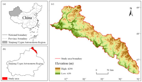
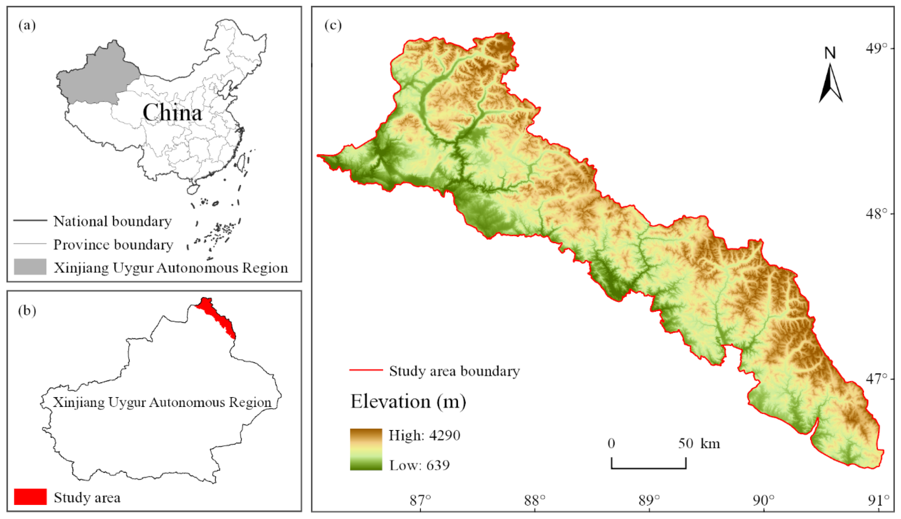
The Chinese Altai Mountains (45°00′–49°10′ N, 85°31′–91°04′ E) cover roughly 2.75 × 10⁴ km2 (Figure 1); located on the Eurasian hinterland, this region exhibits a cold semi-arid temperate continental climate, governed by the influence of the westerlies and the Siberian–Mongolian high, with long, cold winters; short, cool summers; and short transitional seasons. The average annual temperature is 0.7 °C, and annual precipitation ranges from 400 to 1150 mm, strongly associated with altitude [43]. Precipitation increases from 200 to 300 mm in low-elevation regions to nearly 600 mm in mid- and high-mountain areas, with most rainfall occurring in summer. In the high mountains, snow remains for 6–8 months. The mountainous area is dominated by tectonic–erosional high- and mid-altitude mountains with large topographic relief and an elevation difference of more than 3000 m. As cold–temperate mountain forest, these areas have vegetation mainly in their mid-mountain region (1400–2800 m), including Siberian larch (Larix sibirica), Siberian spruce (Picea obovata), and Siberian pine (Pinus sibirica), supported by a rich understory.
Figure 1.
Geographical location and topography of the study area. (a) Location of the Xinjiang Uygur Autonomous Region in China; (b) Location of the study area within the Xinjiang Uygur Autonomous Region; (c) Elevation of the study area based on DEM.
2.2. Data Sources and Preprocessing
The datasets utilized in this study primarily include land use and land cover, climate, soil, and topography data, as well as parameters. All data were obtained from authoritative public datasets or derived using established empirical formulas; detailed sources and descriptions are provided in Table 1. To ensure spatial consistency, all raster datasets were resampled to a unified resolution of 1000 m and projected to the WGS_1984_UTM_Zone_45N coordinate system. Specifically, nearest neighbor resampling was applied to categorical data (e.g., land cover) to preserve class values, while bilinear interpolation was used for continuous data (e.g., climate and DEM).
Table 1.
Data sources.
2.3. Assessment of Ecosystem Services
In this study, we employed the InVEST (Integrated Valuation of Ecosystem Services and Tradeoffs) model (v3.14.0, Natural Capital Project, Stanford University, Stanford, CA, USA) to spatially quantify four key ecosystem services in the study area: carbon storage, water conservation, soil conservation, and habitat quality. Developed by the Natural Capital Project, this open-source GIS tool is extensively applied to model the spatiotemporal dynamics of ecosystem services under various land-use scenarios [51]. Assessments for each service were based on raster data, with input parameters derived from remote sensing imagery and literature databases.
2.3.1. Carbon Storage
The carbon storage service evaluates the static carbon sequestration potential of the ecosystem, encompassing four distinct pools: aboveground biomass, belowground biomass, soil organic matter, and dead organic matter. The InVEST Carbon Storage module was used to calculate carbon stocks via the carbon density summation method. Carbon density coefficients for the four pools were extracted from the 2010s Chinese terrestrial ecosystem carbon dataset [45] (Table 2). The total carbon storage () is calculated as follows:
Table 2.
Carbon density.
signifies the aggregate carbon storage per pixel (t C·hm−2); and represent the carbon density of biomass existing above and below the ground surface, respectively, reflecting the carbon sequestered in living vegetative tissues such as stems and root systems (t C·hm−2); denotes the soil organic carbon (SOC) density, which quantifies the carbon stored within the topmost 100 cm of the soil profile (t C·hm−2); and refers to the carbon density of necromass (dead organic matter), which encompasses the carbon content within the litter layer and coarse woody debris (t C·hm−2).
2.3.2. Water Conservation
In arid regions, the water conservation function of forests primarily manifests through ecosystem maintenance and water supply services [52], which is effectively quantified by the potential runoff generation—defined as the surplus of precipitation after accounting for actual evapotranspiration. This approach recognizes that the net water remaining in the system constitutes the total water resources available for downstream supply and ecological support. To simulate this process, the InVEST Annual Water Yield module was employed based on the annual water balance principle:
is the annual water yield (mm) for pixel with land use type ; is the annual precipitation (mm); and is the annual actual evapotranspiration (mm). The ratio is determined via the Budyko curve approach as formulated by Zhang et al. [53]. Within this framework, is modulated by the plant available water content (PAWC) and the seasonality factor (Z parameter).
2.3.3. Soil Conservation
The soil conservation service quantifies an ecosystem’s capacity to mitigate soil erosion. It is assessed by calculating the avoided soil loss, defined as the discrepancy between theoretical potential erosion and observed actual erosion. Simulations were conducted via the InVEST SDR module, which integrates the RUSLE (Revised Universal Soil Loss Equation) model to estimate sedimentation dynamics. For each pixel, the soil conservation amount () is calculated as follows:
is the soil conservation amount for pixel (t·hm−2); represents potential soil erosion (t·hm−2), determined using by the rainfall erosivity factor (), soil erodibility factor (), and slope length–gradient factor (, derived from DEM); and represents actual soil erosion, calculated by superimposing the vegetation cover and management factor () and the support practice factor () onto the potential erosion ().
2.3.4. Habitat Quality
Habitat quality measures the suitability of an ecosystem to support biodiversity, serving as a proxy for species persistence and ecosystem integrity. The InVEST Habitat Quality module was applied using a threat–response framework. Anthropogenic stressors, specifically urban land, cultivated land, and bare land, were selected as threat sources (Table 3). The quality index () is calculated as follows:
Table 3.
Threat factors.
is the habitat quality index (ranging from 0 to 1) for pixel in habitat type , with higher values indicating better habitat quality; is the habitat suitability score (0–1, Table 4); is the cumulative threat level for the habitat; is a scaling factor (default set to 2.5); and is the half-saturation constant; is the number of threat factors; denotes a specific threat factor; is the number of raster cells for threat factor ; represents the total number of raster cells occupied by threat factor ; is the weight assigned to threat factor , ranging from 0 to 1; is the impact (exponential or linear) of threat factor on each raster cell of the habitat; is the habitat’s resilience level; is the relative sensitivity of habitat type to each threat factor .
Table 4.
Habitat suitability of land use types and sensitivity to different threat factors.
2.4. Statistical Analysis
Data preprocessing, projection transformation, and spatial mapping were performed using ArcGIS Pro 3.0 (Esri Inc., Redlands, CA, USA). To account for the lack of normality in the ecosystem service variables, non-parametric Spearman correlations were calculated at the pixel scale to characterize the horizontal spatial distribution relationships between pairs of ecosystem services. Correlation analysis and heatmap generation were implemented via Python 3.10 (Python Software Foundation, Wilmington, DE, USA), utilizing the SciPy 1.10.1 (SciPy Community, Austin, TX, USA), Pandas 2.0.3 (PyData, New York, NY, USA), and Seaborn 0.12.2 (PyData, New York, NY, USA) libraries. Additionally, zonal statistics tools were used to calculate the mean values of ecosystem services across different elevation gradients (representing the vertical spatial distribution). All statistical charts were produced using Python 3.10.
3. Results
3.1. Horizontal Spatial Distribution Patterns of Forest Ecosystem Services in the Chinese Altai Mountains
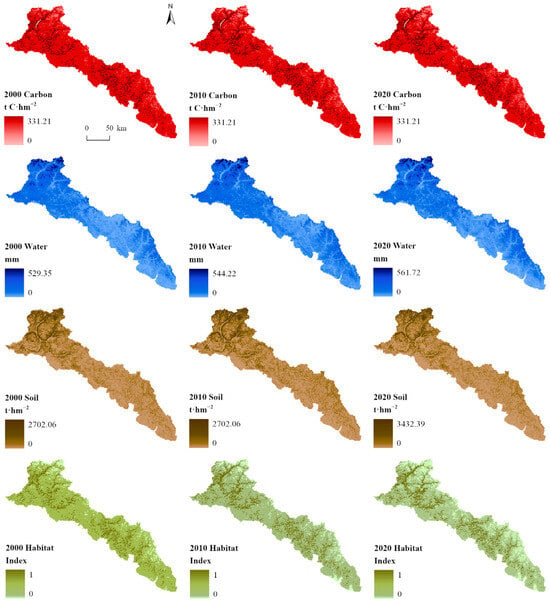
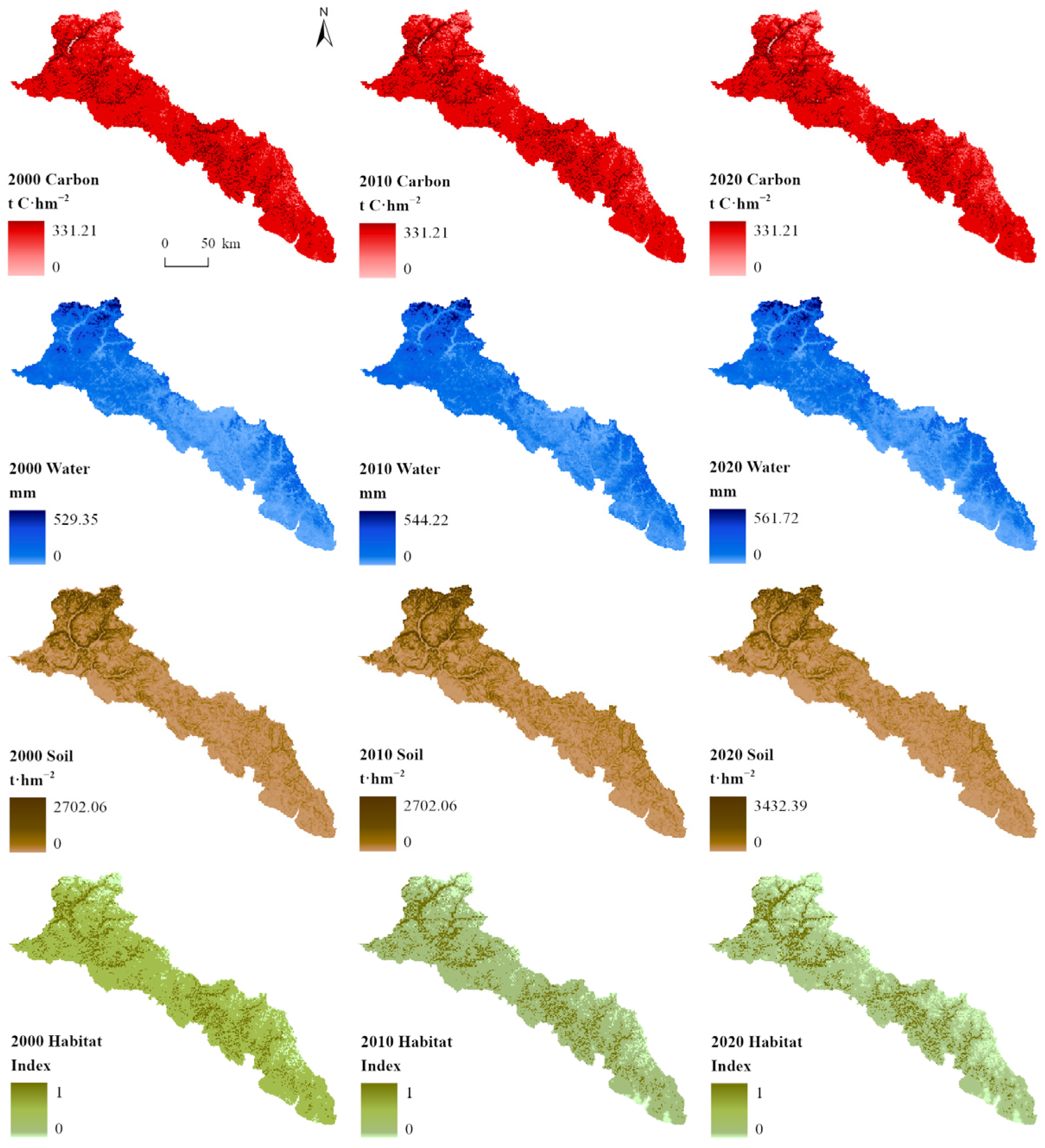
Spatially, the ecosystem services in the Chinese Altai Mountains exhibited distinct geographic differentiations (Figure 2), governed by altitudinal gradients. Water conservation generally displayed a “high-North, low-South” pattern, with high-provision areas distributed mainly across the northern and north-eastern montane sectors. Similarly, soil conservation followed a “high-Northwest, low-Southeast” distribution, with high intensities concentrated in the high-altitude areas of the northwest. Conversely, both carbon storage and habitat quality were characterized by a central aggregation. Areas with high carbon density were primarily concentrated in the contiguous central region, while lower levels were found at the northern tip and northeastern edges. High-habitat-quality areas were also concentrated in the central core zone, whereas low-quality areas were primarily distributed along the southwestern fringe.
Figure 2.
Spatial distribution of carbon storage, water retention, soil conservation, and habitat quality in the Chinese Altai Mountains’ forest ecosystems for the years 2000, 2010, and 2020.
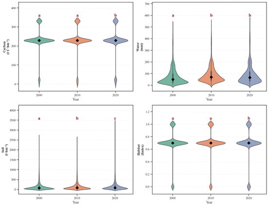
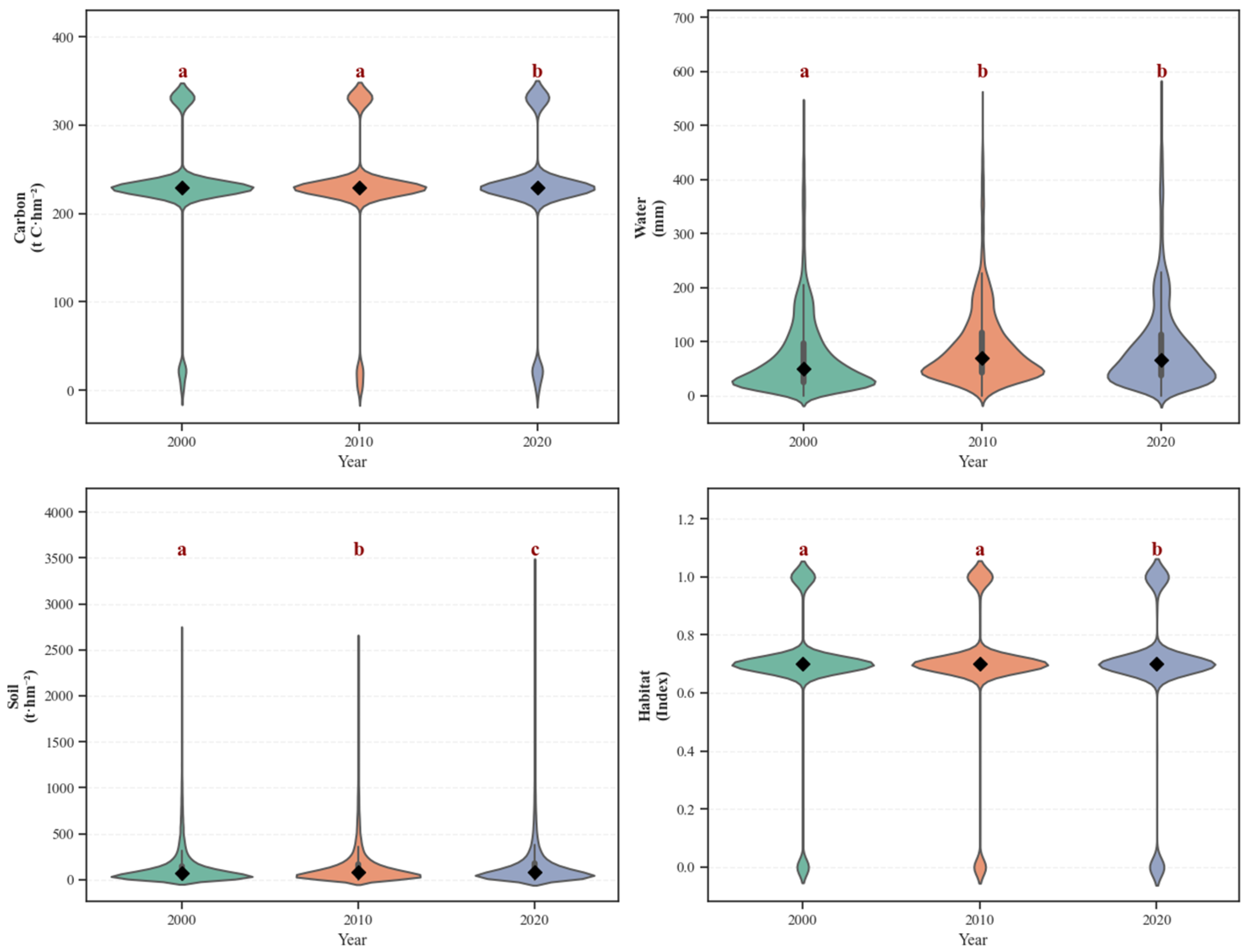
Temporally, from 2000 to 2020, the four ecosystem services showed divergent trends (Figure 3). Water conservation capacity was notably enhanced, rising continuously from 73.61 mm to 90.93 mm—an increase of roughly 23.5%, with rapid growth observed between 2000 and 2010. Soil conservation showed a stable linear growth trend, with significant changes between the first and second decades; over the 20-year period, it increased cumulatively by 24.74 t·hm−2, reaching an expansion of 18.6%. Conversely, carbon storage generally exhibited a downward trend. Carbon density stayed largely constant over the first decade but experienced a significant decline to 225.97 t C·hm−2 in 2020, representing a reduction of roughly 1.9% relative to the initial period. Habitat quality exhibited a “rise-then-fall” characteristic: after a slight increase in 2010, it significantly degraded to 0.679 by 2020, falling below the level observed at the beginning of the study.
Figure 3.
Temporal changes in carbon storage, water retention, soil conservation, and habitat quality of forest ecosystems in the Chinese Altai Mountains (2000, 2010, and 2020). Distinct letters denote statistically significant variations across years based on the Tukey HSD test (), whereas identical letters represent no significant discrepancy.
3.2. Correlations Among the Horizontal Spatial Distributions of Forest Ecosystem Services in the Chinese Altai Mountains
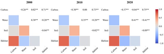
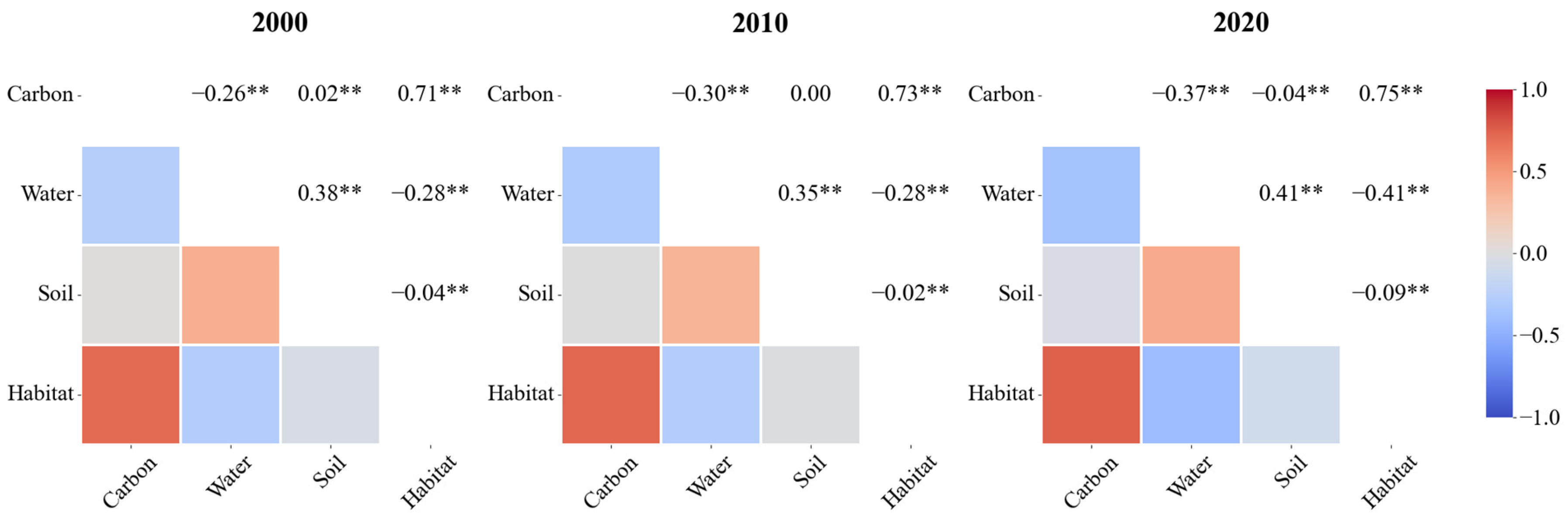
Over the 20-year period, the horizontal spatial correlations (representing the regional trade-off and synergy patterns) among forest ecosystem services in the Chinese Altai Mountains remained generally stable, while the intensity of these correlations exhibited distinct variations (Figure 4). Carbon storage and habitat quality demonstrated a highly significant positive spatial correlation (). The correlation coefficient rose continuously from 0.71 to 0.75, indicating that their spatial distributions were the most consistent among all pairs and that this consistency strengthened over time. In contrast, carbon storage and water conservation exhibited a highly significant negative correlation (). The correlation coefficient decreased from −0.26 to −0.37, suggesting an intensification of spatial divergence. The correlation between carbon storage and soil conservation was weak, showing only marginal positive (0.02) and negative (−0.04) associations in 2010 and 2020, respectively.
Figure 4.
Correlation analysis of the spatial distribution of forest ecosystem services in the Chinese Altai Mountains (2000, 2010, and 2020). * indicates significance at the 0.05 level, and ** indicates significance at the 0.01 level.
Water conservation and soil conservation maintained a relatively stable positive correlation (), with coefficients fluctuating between 0.35 and 0.41; however, water conservation and habitat quality displayed a marked inverse relationship (), with its corresponding value shifting from −0.28 to −0.41. Meanwhile, soil conservation and habitat quality consistently maintained a weak negative correlation throughout the study period ( ranging from −0.09 to −0.02). In summary, the internal structure of the forest ecosystem in the Chinese Altai Mountains is characterized by dominant synergistic patterns (positive correlations) between carbon storage–habitat quality and water conservation–soil conservation. Conversely, the spatial trade-offs (negative correlations) observed between water conservation–carbon storage and water conservation–habitat quality represent the primary conflicts facing regional management.
3.3. Vertical Spatial Distribution Patterns of Forest Ecosystem Services in the Chinese Altai Mountains
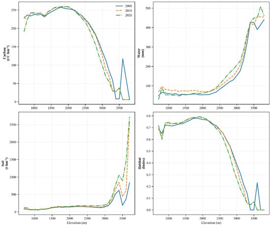
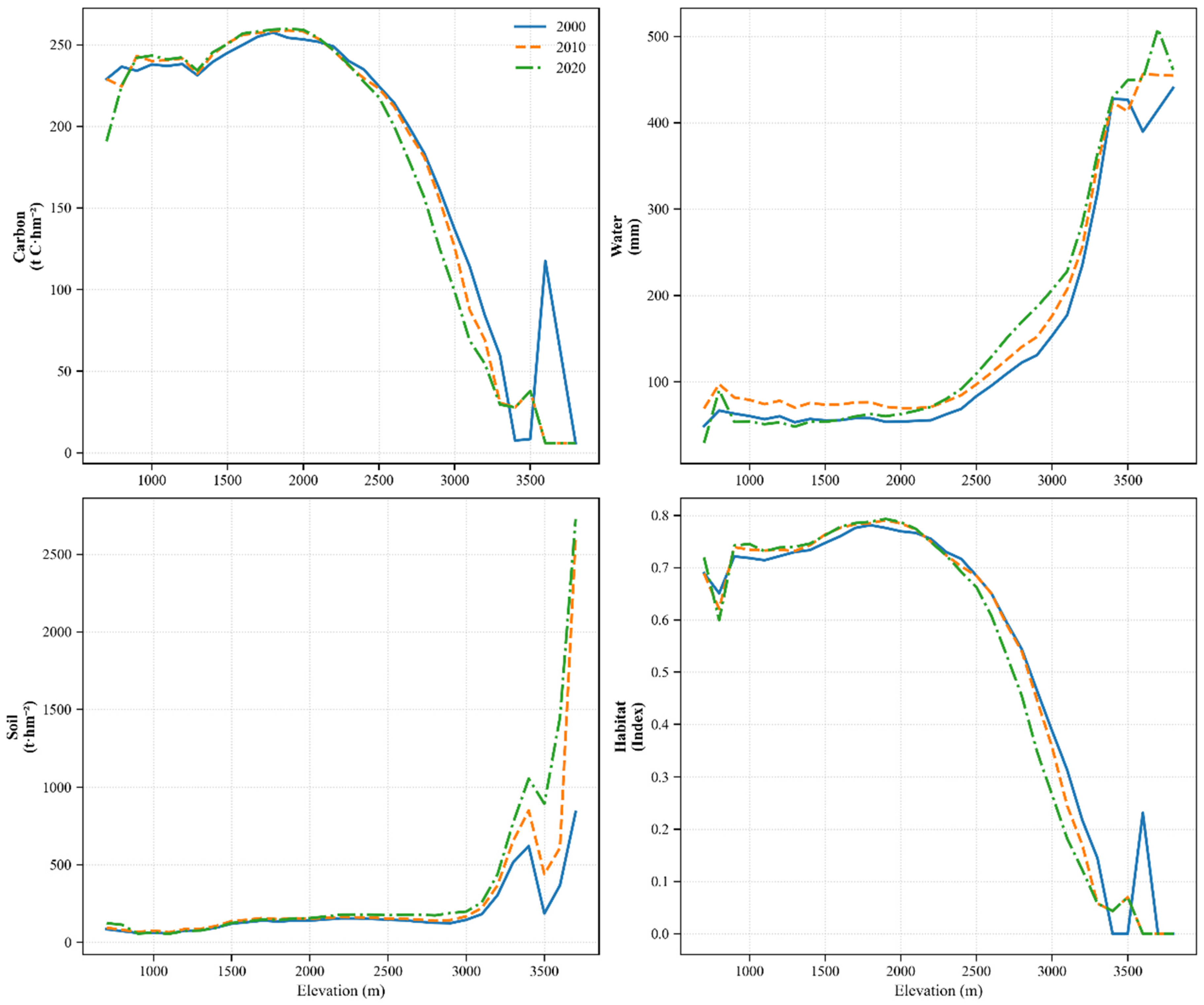
Carbon storage density maintained high levels (exceeding 200 t·hm−2) within the elevation range of 700–2500 m (Figure 5); it reached a peak of approximately 260 t·hm−2 near 1800 m, before declining rapidly at elevations above 2500 m. Water conservation remained at relatively low levels (below 100 mm) at elevations under 2500 m; however, above 2500 m, it increased sharply with elevation, surpassing 400 mm at approximately 3400 m. Soil conservation showed minimal fluctuation below 3000 m, remaining at low levels (under 250 t·hm−2); beyond 3000 m, however, it exhibited a generally steep upward trend. Habitat quality followed a trend similar to that of carbon storage, maintaining high levels (above 0.6) between 700 and 2500 m; it peaked at approximately 0.8 near 1800 m and decreased rapidly at elevations exceeding 2500 m.
Figure 5.
Altitudinal distribution of carbon storage, water retention, soil conservation, and habitat quality in the Chinese Altai Mountains (2000, 2010, and 2020).
4. Discussion
4.1. Spatial Distribution Characteristics of Forest Ecosystem Services in the Chinese Altai Mountains
The areas with high carbon density and habitat quality in the forest ecosystem of the Chinese Altai Mountains are concentrated in the contiguous central forest zone, reflecting the spatial coupling between biomass accumulation and biodiversity support functions. In contrast, hotspots for water and soil conservation are situated in the northern high-altitude regions; these distinct spatial patterns are primarily co-driven by precipitation gradients and vegetation zonality. Precipitation in the Chinese Altai mainly originates from Atlantic moisture transported by the Westerlies [54]. As the northern region is closer to moisture sources and subject to orographic uplift, precipitation increases from south to north and from low to high elevations, establishing a “high-North, low-South” precipitation gradient.
Concurrently, topographic factors govern the vertical zonation of vegetation by redistributing hydrothermal resources [31], thereby dominating the vertical distribution characteristics of ecosystem services. Notably, the high-provision zones for different ecosystem services in the Chinese Altai Mountains do not vertically overlap. The peaks for carbon storage and habitat quality occur in the mid-elevation zones, primarily due to the optimal coupling of hydrothermal conditions. In low-elevation regions, high temperatures induce intense evapotranspiration, subjecting vegetation to drought stress and limiting biomass accumulation. Conversely, in high-elevation regions, low temperatures shorten the growing season and retard photosynthetic metabolism [37]. The mid-elevation zone acts as an “intermediate belt” that alleviates the moisture constraints of lower elevations while avoiding the thermal limitations of higher elevations [55], creating a favorable environment for coniferous forests such as Siberian larch. Consequently, this zone accumulates substantial carbon stocks and maintains exceptional habitat quality, supported by complex stand structures and minimal anthropogenic disturbance [36].
In contrast, high-elevation zones are critical supply areas for water conservation. Functioning as “natural water towers,” their high water yields are derived primarily from glacial and snow meltwater combined with lower evapotranspiration rates [56]. Although the mid-elevation forests are dense, canopy interception and transpiration consume significant amounts of water; thus, their direct contribution to catchment runoff is substantially lower than those of the high-elevation alpine meadows and glacial zones [37], indicating that, in arid mountainous regions, increased vegetation coverage does not necessarily enhance water yield; rather, the low water consumption characteristics associated with low-temperature, high-altitude environments are key to sustaining high runoff.
Furthermore, soil conservation reflects the interaction between topographic relief and vegetation coverage. Although the mid-elevation zones feature steeper terrain with higher theoretical erosion risk, the high-canopy-density forests effectively counteract this risk by attenuating rainfall kinetic energy through canopy interception and anchoring soil via root systems [57]. Conversely, despite gentler slopes in low-elevation regions, soil retention capacity is weaker due to sparse vegetation and disturbances such as grazing [37]. However, it is important to note that these results are derived from the InVEST model, based on simplified biophysical parameters; while effective for simulating regional spatial patterns, the lack of extensive field monitoring data for pixel-level validation remains a limitation that should be considered in future assessments.
4.2. Spatial Divergence Between Carbon Storage and Water Conservation Services in the Forest Ecosystem of the Chinese Altai Mountains
Carbon storage and water conservation in the forest ecosystem of the Chinese Altai Mountains exhibited a significant negative correlation, characterized by distinct spatial divergence that has intensified over time. Unlike previous static assessments, our results quantify a rapid escalation of this conflict (with the correlation coefficient dropping from −0.26 to −0.37), offering dynamic evidence that extends the “trading water for carbon” hypothesis [26], confirming that enhancements in vegetation carbon sequestration capacity often come at the expense of water resource consumption [27]. Since the implementation of the Natural Forest Protection Project in Xinjiang in 2000, both the area and quality of forests in the study region have significantly improved [58]. However, as forest canopy density increases, complex canopy structures significantly enhance precipitation interception rates. Simultaneously, well-developed tree root systems intensify transpiration by accessing deep soil moisture, thereby substantially reducing catchment runoff; this reduction poses a critical challenge for the downstream beneficiaries, specifically the arid oasis agriculture and human settlements in the Irtysh River basin that rely heavily on mountain runoff for irrigation and domestic water. Consequently, the trade-off effect of “carbon gain, water loss” has become increasingly prominent [59].
From a physiological perspective, this trade-off stems from the coupling of plant carbon and water metabolism: as stomata open to uptake carbon dioxide for biomass accumulation, water is inevitably lost through transpiration [60,61]. Particularly in water-limited arid environments, vegetation must maintain high transpiration rates to sustain high productivity; this physiological carbon–water coupling dictates that the enhancement of carbon sink functions entails high-intensity water consumption, a process further exacerbated under extreme climatic conditions [62].
Furthermore, the persistent intensification of the above spatial divergence suggests that regional vegetation restoration may be approaching the threshold of water resource carrying capacity [63]. Although water conservation in the Chinese Altai Mountains generally displays a positive progression, if the rate of increase in vegetation water consumption exceeds the increase in precipitation recharge, the potential for actual water supply will be constrained. Similar phenomena have been documented in other arid regions, such as the Loess Plateau [41]. Therefore, future ecological management must prioritize the balance between physiological water use by vegetation and catchment runoff, avoiding negative feedback effects on the eco-hydrological system caused by the sole pursuit of carbon sinks [64].
4.3. Conservation and Management Strategies for the Forest Ecosystem of the Chinese Altai Mountains
Given the pronounced spatial divergence of ecosystem services within the Chinese Altai Mountains, management paradigms must evolve toward spatially differentiated zoning to effectively mitigate service trade-offs while safeguarding core functions [65].
In the critical water conservation areas of the northern and northeastern high elevations, this entails implementing strict protection strategies, ideally by incorporating these regions into Ecological Conservation Red Lines. Restricting anthropogenic disturbances—specifically grazing and mining—is vital to preserve the natural hydrological regulation of alpine meadows and permafrost, thereby maximizing their capacities for precipitation interception and runoff regulation.
Transitioning to the mid-elevation forest zones (1400–2400 m), the management focus should shift from mere area expansion to the enhancement of forest quality. As continued high-density afforestation in this belt risks exacerbating the competition between water yield and carbon sequestration [66], such aggressive planting schemes are inadvisable. Instead, adhering to the principle of “determining forest establishment based on water availability,” management should prioritize measures such as moderate thinning and stand structure optimization; these interventions can effectively reduce canopy density and transpiration losses, alleviating the interception of catchment runoff and promoting a synergistic balance between carbon and water [67].
Regarding the low-elevation fringe zones in the southwest, priority must be placed on restoration and connectivity. Fragmented habitats in these areas require rehabilitation through initiatives such as the Grain for Green program and the development of ecological corridors to serve as biodiversity buffers. Moreover, by remaining vigilant against agricultural encroachment on forest edges and refining the protected area network centered around national parks—policymakers can strike a sustainable balance between regional economic development and ecological conservation [68,69]. From a long-term perspective, these management strategies must also be adaptive to climate change. Future research should integrate these zoning approaches with climate prediction models (e.g., CMIP6) to anticipate how the water–carbon trade-offs will evolve under different warming scenarios.
5. Conclusions
In this study, by utilizing datasets including climate, land cover, and soil surveys, we quantified the spatial distribution and correlations of forest ecosystem services in the Chinese Altai Mountains from 2000 to 2020. The results indicated distinct temporal trends among these services: water conservation and soil conservation capacities enhanced significantly, whereas carbon storage and habitat quality exhibited a slight decline. Driven by elevation gradients, these ecosystem services displayed pronounced vertical distribution characteristics. The mid-elevation zones (1400–2400 m) served as the primary concentration areas for carbon storage and habitat quality, while the high-elevation zones (above 2400 m) were identified as critical areas for water and soil conservation. Notably, a significant synergistic pattern was observed between carbon storage and habitat quality (r = 0.75). In contrast, a significant and intensifying negative correlation was confirmed between carbon storage and water conservation (with the coefficient dropping to −0.37), highlighting the competitive trade-offs between “water–carbon” functions in the region. Consequently, management strategies for the Chinese Altai Mountains forest ecosystem should fully account for this vertical divergence and the correlations among services. It is recommended to prioritize the alleviation of forest–water contradictions in the mid-elevation zones through stand structure optimization, while strictly maintaining natural hydrological regulation functions in the high-elevation zones, thereby achieving comprehensive enhancement of regional ecological benefits.
Author Contributions
Conceptualization, S.X. and J.H.; methodology, S.X., S.D., and B.S.; software, S.X. and S.D.; validation, S.X., S.D., and B.S.; formal analysis, S.X.; resources, J.H. and R.Z.; data curation, S.X. and B.S.; writing—original draft preparation, S.X.; writing—review and editing, J.H., L.W., W.W., Z.G., Y.X., J.Y., Y.D., and R.Z.; visualization, S.X. and S.D.; supervision, J.H.; project administration, J.H.; funding acquisition, J.H. and R.Z. All authors have read and agreed to the published version of the manuscript.
Funding
This research was supported by the China-EU International Cooperation Project under the National Key Research and Development Program of China (2023YFE0112800).
Data Availability Statement
The data presented in this study are derived from public domain resources, as detailed in Table 1.
Conflicts of Interest
The authors declare no conflicts of interest.
References
- Gallardo, B.; Aldridge, D.C.; González-Moreno, P.; Pergl, J.; Pizarro, M.; Pyšek, P.; Thuiller, W.; Yesson, C.; Vilà, M. Protected Areas Offer Refuge from Invasive Species Spreading under Climate Change. Glob. Change Biol. 2017, 23, 5331–5343. [Google Scholar] [CrossRef] [Scilit] [PubMed]
- Antonelli, A.; Kissling, W.D.; Flantua, S.G.A.; Bermúdez, M.A.; Mulch, A.; Muellner-Riehl, A.N.; Kreft, H.; Linder, H.P.; Badgley, C.; Fjeldså, J.; et al. Geological and Climatic Influences on Mountain Biodiversity. Nat. Geosci. 2018, 11, 718–725. [Google Scholar] [CrossRef] [Scilit]
- Wen, A.; Tang, Q.; Ouyang, C.; Zhu, B.; Wang, Y.; Li, A.; Li, S.; Zhu, W.; Liu, L. Mountain Protection and Mountain Development in China:Review and Prospect. Bull. Chin. Acad. Sci. 2023, 38, 376–384. [Google Scholar] [CrossRef]
- García-Rodríguez, A.; Lenzner, B.; Velasco, J.A.; Schertler, A.; Omer, A.; Seebens, H.; Capinha, C.; Gallardo, B.; Dullinger, S.; Essl, F. The Global Distribution Patterns of Alien Vertebrate Richness in Mountains. Nat. Commun. 2025, 16, 1977. [Google Scholar] [CrossRef] [Scilit]
- Duguma, L. Mountain Forests in a Changing World: Realising Values, Addressing Challenges; Food and Agriculture Organization: Rome, Italy, 2011. [Google Scholar] [CrossRef] [Scilit]
- Wang, B.; Ren, X.; Hu, W. Assessment of Forest Ecosystem Services Value in China. Sci. Silvae Sin. 2011, 47, 145. [Google Scholar] [CrossRef]
- Xie, G.; Zhang, C.; Zhang, C.; Xiao, Y.; Lu, C. The Value of Ecosystem Services in China. Resour. Sci. 2015, 37, 1740–1746. [Google Scholar]
- Wu, Z.; Zeng, H. Evaluation of Forest Ecosystem Services Value in China Based on Meta-Analysis. Acta Ecol. Sin. 2021, 41, 5533–5545. [Google Scholar] [CrossRef] [Scilit]
- Wang, J.; Yu, P.; Wang, Y. (Eds.) Study on Forest Eco-Hydrological Processes: A Case Study of Water Conservation Forests in the Qilian Mountains, Gansu Province, 1st ed.; Science Press: Beijing, China, 2008; ISBN 978-7-03-022446-0. [Google Scholar]
- Ma, P.; Wang, Z.; Li, Q.; Wang, S.; Zhang, S.; Zhao, Y. Evaluation of Forest Ecosystem Services in Beidaihe District of Qihuangdao City. Bull. Soil Water Conserv. 2018, 38, 286–292. [Google Scholar] [CrossRef]
- Barman, J.; Bhattacharya, R.N. Internalizing Community in Forest Conservation: A Developing Country Perspective. J. Environ. Syst. 2004, 31, 239–256. [Google Scholar] [CrossRef] [Scilit]
- Xu, Y.; Zhou, B.; Yu, L.; Shi, Y.; Xu, Y. Temporal-Spatial Dynamic Pattern of Forest Ecosystem Service Value Affected by Climate Change in the Future in China. Acta Ecol. Sin. 2018, 38, 1952–1963. [Google Scholar] [CrossRef] [Scilit]
- Zhang, Z.; Shi, X.; Hossain, M.S. Ecosystem Services and Land Use Change Research in the Mountain Regions of China: A Systematic Review. Int. J. Sustain. Dev. World Ecol. 2026, 33, 29–48. [Google Scholar] [CrossRef] [Scilit]
- Costanza, R.; d’Arge, R.; de Groot, R.; Farber, S.; Grasso, M.; Hannon, B.; Limburg, K.; Naeem, S.; O’Neill, R.V.; Paruelo, J.; et al. The Value of the World’s Ecosystem Services and Natural Capital. Nature 1997, 387, 253–260. [Google Scholar] [CrossRef] [Scilit]
- Postel, S.; Bawa, K.; Kaufman, L.; Peterson, C.H.; Carpenter, S.; Tillman, D.; Dayton, P.; Alexander, S.; Lagerquist, K.; Goulder, L.; et al. Nature’s Services: Societal Dependence on Natural Ecosystems; Daily, G.C., Ed.; Island Press: Washington, DC, USA, 1997; ISBN 978-1-55963-475-5. [Google Scholar]
- Ouyang, Z.; Zheng, H.; Xiao, Y.; Polasky, S.; Liu, J.; Xu, W.; Wang, Q.; Zhang, L.; Xiao, Y.; Rao, E.; et al. Improvements in Ecosystem Services from Investments in Natural Capital. Science 2016, 352, 1455–1459. [Google Scholar] [CrossRef] [Scilit]
- Zhao, J.; Xiao, H.; Wu, G. Comparison Analysis on Physical and Value Assessment Methods for Ecosystems Services. Chin. J. Appl. Ecol. 2000, 11, 290–292. [Google Scholar]
- Yuan, Z.; Wan, R. A Review on the Methods of Ecosystem Service Assessment. Ecol. Sci. 2019, 38, 210. [Google Scholar]
- Odum, H.T.; Odum, E.P. The Energetic Basis for Valuation of Ecosystem Services. Ecosystems 2000, 3, 21–23. [Google Scholar] [CrossRef] [Scilit]
- Nelson, E.; Mendoza, G.; Regetz, J.; Polasky, S.; Tallis, H.; Cameron, D.R.; Chan, K.M.A.; Daily, G.C.; Goldstein, J.; Kareiva, P.M.; et al. Modeling Multiple Ecosystem Services, Biodiversity Conservation, Commodity Production, and Tradeoffs at Landscape Scales. Front. Ecol. Environ. 2009, 7, 4–11. [Google Scholar] [CrossRef] [Scilit]
- He, C.; Zhang, D.; Huang, Q.; Zhao, Y. Assessing the Potential Impacts of Urban Expansion on Regional Carbon Storage by Linking the LUSD-Urban and InVEST Models. Environ. Model. Softw. 2016, 75, 44–58. [Google Scholar] [CrossRef] [Scilit]
- GB/T 38582-2020; Specifications for Assessment of Forest Ecosystem Services. Research Institute of Forest Ecology, Environment and Protection, Chinese Academy of Forestry: Beijing, China, 2020.
- Foley, J.A.; DeFries, R.; Asner, G.P.; Barford, C.; Bonan, G.; Carpenter, S.R.; Chapin, F.S.; Coe, M.T.; Daily, G.C.; Gibbs, H.K.; et al. Global Consequences of Land Use. Science 2005, 309, 570–574. [Google Scholar] [CrossRef] [Scilit]
- He, C.; Xiong, K.; Rong, L. Trade-Offs and Synergies of Ecosystem Services and Their Drivers in the Forests of the South China Karst. NPJ Herit. Sci. 2025, 13, 298. [Google Scholar] [CrossRef] [Scilit]
- Lee, H.; Lautenbach, S. A Quantitative Review of Relationships between Ecosystem Services. Ecol. Indic. 2016, 66, 340–351. [Google Scholar] [CrossRef] [Scilit]
- Griebel, A.; Bennett, L.T.; Metzen, D.; Pendall, E.; Lane, P.N.J.; Arndt, S.K. Trading Water for Carbon: Maintaining Photosynthesis at the Cost of Increased Water Loss During High Temperatures in a Temperate Forest. J. Geophys. Res. Biogeosci. 2020, 125, e2019JG005239. [Google Scholar] [CrossRef] [Scilit]
- Sun, G.; Zhou, G.; Zhang, Z.; Wei, X.; McNulty, S.G.; Vose, J.M. Potential Water Yield Reduction Due to Forestation across China. J. Hydrol. 2006, 328, 548–558. [Google Scholar] [CrossRef] [Scilit]
- Jackson, R.B.; Jobbágy, E.G.; Avissar, R.; Roy, S.B.; Barrett, D.J.; Cook, C.W.; Farley, K.A.; Le Maitre, D.C.; McCarl, B.A.; Murray, B.C. Trading Water for Carbon with Biological Carbon Sequestration. Science 2005, 310, 1944–1947. [Google Scholar] [CrossRef] [Scilit]
- Still, C.J. Trading Water for Carbon. Nat. Geosci. 2018, 11, 702–703. [Google Scholar] [CrossRef] [Scilit]
- Fang, J.; Shen, Z.; Tang, Z.; Wang, Z. The Protocol for the Survey Plan for Plant Species Diversity of China′s Mountains. Biodivers. Sci. 2004, 12, 5–9. [Google Scholar]
- Stein, A.; Gerstner, K.; Kreft, H. Environmental Heterogeneity as a Universal Driver of Species Richness across Taxa, Biomes and Spatial Scales. Ecol. Lett. 2014, 17, 866–880. [Google Scholar] [CrossRef] [Scilit]
- Liu, Y.; Xiong, M.; Han, Y.; Tang, Y.; Liu, Z.; Sun, H.; Wang, X. The Influencing Factors of Biomass and Productivity in the Mount Altay Taiga under Environmental Changes. Acta Ecol. Sin. 2025, 45, 11268–11280. [Google Scholar] [CrossRef]
- Chen, L. Biodiversity in China: Status and Conservation Strategies; Science Press: Beijing, China, 1993. [Google Scholar]
- Chinese Academy of Sciences Xinjiang Comprehensive Expedition Team. Vegetation and Its Utilization in Xinjiang; Science Press: Beijing, China, 1978. [Google Scholar]
- Xiong, J. Comprehensive Scientific Expedition of the Altai Mountains in Xinjiang; China Forestry Publishing House: Beijing, China, 2020. [Google Scholar]
- Fang, J.-Y. Exploring Altitudinal Patterns of Plant Diversity of China’s Mountains. Biodivers. Sci. 2004, 12, 1. [Google Scholar] [CrossRef] [Scilit]
- He, Z.; Du, J.; Chen, L.; Zhu, X.; Zhao, M. Review on Montane Forest Eco-hydrology in Arid Area. Adv. Earth Sci. 2016, 31, 1078. [Google Scholar] [CrossRef]
- Fu, B.; Zhuang, X.; Jiang, G.; Shi, J.; Lu, A.Y. FEATURE: Environmental Problems and Challenges in China. Environ. Sci. Technol. 2007, 41, 7597–7602. [Google Scholar] [CrossRef] [Scilit]
- Hanchu, L.; Jie, F.; Baoyin, L.; Li, W.; Qin, Q. Practical Exploration of Ecological Restoration and Management of the Mountains-Rivers-Forests-Farmlands-Lakes-Grasslands System in the Irtysh River Basin in Altay, Xinjiang. J. Resour. Ecol. 2021, 12, 766–776. [Google Scholar] [CrossRef] [Scilit]
- Dragonetti, C.; Daskalova, G.; Di Marco, M. The Exposure of the World’s Mountains to Global Change Drivers. iScience 2024, 27, 109734. [Google Scholar] [CrossRef] [Scilit] [PubMed]
- Feng, X.; Fu, B.; Piao, S.; Wang, S.; Ciais, P.; Zeng, Z.; Lü, Y.; Zeng, Y.; Li, Y.; Jiang, X.; et al. Revegetation in China’s Loess Plateau Is Approaching Sustainable Water Resource Limits. Nat. Clim. Change 2016, 6, 1019–1022. [Google Scholar] [CrossRef] [Scilit]
- Yi, S.; Wang, H.; Xie, L.; Wang, C.; Huang, X. Spatio-Temporal Dynamics and Drivers of Ecosystem Service Bundles in the Altay Region: Implications for Sustainable Land Management. Land 2024, 13, 805. [Google Scholar] [CrossRef] [Scilit]
- Sun, Q.; Zhou, H. Service Function and Value Evaluation of the Altai Mountains Forest Ecosystem. Arid Land Geogr. 2020, 43, 1327–1336. [Google Scholar]
- Yang, J.; Huang, X. The 30 m Annual Land Cover Datasets and Its Dynamics in China from 1985 to 2024; Zenodo: Geneva, Switzerland, 2025. [Google Scholar]
- Xu, L.; He, N.; Yu, G. A Dataset of Carbon Density in Chinese Terrestrial Ecosystems (2010s); Science Data Bank: Beijing, China, 2018. [Google Scholar]
- Peng, S. 1-Km Monthly Potential Evapotranspiration Dataset for China (1901–2024); National Tibetan Plateau Data Center: Bejing, China, 2025.
- Yan, F.; Shangguan, W.; Zhang, J.; Hu, B. Depth-to-Bedrock Map of China at a Spatial Resolution of 100 Meters. Sci. Data 2020, 7, 2. [Google Scholar] [CrossRef] [Scilit]
- Zhou, W.; Liu, G.; Pan, J.; Feng, X. Distribution of Available Soil Water Capacity in China. J. Geogr. Sci. 2005, 15, 3–12. [Google Scholar] [CrossRef] [Scilit]
- Dai, Y.; Shangguan, W. Dataset of Soil Properties for Land Surface Modeling over China; National Tibetan Plateau Data Center: Bejing, China, 2019.
- Pan, L. Simulation of Water Purification Function of Ecological System Under the Future Land Use Scenarios in Nanjing. Master’s Thesis, Nanjing University of Information Science and Technology, Nanjing, China, 2016. [Google Scholar]
- Natural Capital Project. InVEST 3.17.2: Integrated Valuation of Ecosystem Services and Tradeoffs; Stanford University: Stanford, CA, USA, 2025. [Google Scholar]
- Zhou, J.; Gao, J.; Gao, Z.; Yang, W. Analyzing the Water Conservation Service Function of the Forest Ecosystem. Acta Ecol. Sin. 2018, 38, 1679–1686. [Google Scholar] [CrossRef] [Scilit]
- Zhang, L.; Hickel, K.; Dawes, W.R.; Chiew, F.H.S.; Western, A.W.; Briggs, P.R. A Rational Function Approach for Estimating Mean Annual Evapotranspiration. Water Resour. Res. 2004, 40, 2003WR002710. [Google Scholar] [CrossRef] [Scilit]
- Duan, L.; Wang, S.; Zhang, M.; Wang, L. Stable Hydrogen and Oxygen Isotopes in Precipitation and Water Vapor Source in the Altay Mountains. Arid Land Geogr. 2022, 45, 1042–1049. [Google Scholar]
- Tang, Z.; Fang, J. A Review on the Elevational Patterns of Plant Species Diversity. Biodivers. Sci. 2004, 12, 9. [Google Scholar] [CrossRef] [Scilit]
- Viviroli, D.; Dürr, H.H.; Messerli, B.; Meybeck, M.; Weingartner, R. Mountains of the World, Water Towers for Humanity: Typology, Mapping, and Global Significance. Water Resour. Res. 2007, 43, W0744. [Google Scholar] [CrossRef] [Scilit]
- Yao, K.; Ke, D.; Cheng, B.; He, L. Spatiotemporal Variation and Driving Factors of Soil Erosion in Panxi Region. J. Hunan Agric. Univ. (Nat. Sci.) 2025, 51, 83. [Google Scholar] [CrossRef]
- Li, J.; Wang, L. Dynamic Assessment of the Ecological Benefits of the Natural Forest Protection Project in Xinjiang. For. Xinjiang 2020, 5, 29–31. [Google Scholar]
- Ma, T.; Wang, T.; Yang, D.; Yang, S. Impacts of Vegetation Restoration on Water Resources and Carbon Sequestration in the Mountainous Area of Haihe River Basin, China. Sci. Total Environ. 2023, 869, 161724. [Google Scholar] [CrossRef] [Scilit]
- Trifilò, P.; Casolo, V.; Raimondo, F.; Petrussa, E.; Boscutti, F.; Lo Gullo, M.A.; Nardini, A. Effects of Prolonged Drought on Stem Non-Structural Carbohydrates Content and Post-Drought Hydraulic Recovery in Laurus nobilis L.: The Possible Link between Carbon Starvation and Hydraulic Failure. Plant Physiol. Biochem. 2017, 120, 232–241. [Google Scholar] [CrossRef] [Scilit]
- Liang, X.-G.; Gao, Z.; Shen, S.; Paul, M.J.; Zhang, L.; Zhao, X.; Lin, S.; Wu, G.; Chen, X.-M.; Zhou, S.-L. Differential Ear Growth of Two Maize Varieties to Shading in the Field Environment: Effects on Whole Plant Carbon Allocation and Sugar Starvation Response. J. Plant Physiol. 2020, 251, 153194. [Google Scholar] [CrossRef] [Scilit]
- Yuan, X.; Jiao, L.; Li, Q.; Xue, R.; Wang, X.; Guo, Z.; Zhang, K. The Response of Water-Carbon Coupling to Drought Stress in Terrestrial Ecosystems in China. J. Arid Environ. 2026, 232, 105474. [Google Scholar] [CrossRef] [Scilit]
- Zhou, W.; Li, C.; Fu, B.; Wang, S.; Ren, Z.; Stringer, L.C. Changes and Drivers of Vegetation Productivity in China’s Drylands under Climate Change. Environ. Res. Lett. 2024, 19, 114001. [Google Scholar] [CrossRef] [Scilit]
- Lü, Y.; Fu, B.; Feng, X.; Zeng, Y.; Liu, Y.; Chang, R.; Sun, G.; Wu, B. A Policy-Driven Large Scale Ecological Restoration: Quantifying Ecosystem Services Changes in the Loess Plateau of China. PLoS ONE 2012, 7, e31782. [Google Scholar] [CrossRef] [Scilit]
- Nguyen, T.T. Gains and Losses in Ecosystem Services: Trade-Off and Efficiency Perspectives. Ph.D. Thesis, University of Bayreuth, Bayreuth, Germany, 2025. [Google Scholar] [CrossRef] [Scilit]
- Cao, S. Why Large-Scale Afforestation Efforts in China Have Failed to Solve the Desertification Problem. Environ. Sci. Technol. 2008, 42, 1826–1831. [Google Scholar] [CrossRef] [Scilit] [PubMed]
- Cao, S.; Chen, L.; Shankman, D.; Wang, C.; Wang, X.; Zhang, H. Excessive Reliance on Afforestation in China’s Arid and Semi-Arid Regions: Lessons in Ecological Restoration. Earth-Sci. Rev. 2011, 104, 240–245. [Google Scholar] [CrossRef] [Scilit]
- Palomo, I.; Montes, C.; Martín-López, B.; González, J.A.; García-Llorente, M.; Alcorlo, P.; Mora, M.R.G. Incorporating the Social–Ecological Approach in Protected Areas in the Anthropocene. BioScience 2014, 64, 181–191. [Google Scholar] [CrossRef] [Scilit]
- Wang, B.; Cheng, W.; Lan, S. Impact of Land Use Changes on Habitat Quality in Altay Region. J. Resour. Ecol. 2021, 12, 715–728. [Google Scholar] [CrossRef] [Scilit]

Disclaimer/Publisher’s Note: The statements, opinions and data contained in all publications are solely those of the individual author(s) and contributor(s) and not of MDPI and/or the editor(s). MDPI and/or the editor(s) disclaim responsibility for any injury to people or property resulting from any ideas, methods, instructions or products referred to in the content. |
© 2026 by the authors. Licensee MDPI, Basel, Switzerland. This article is an open access article distributed under the terms and conditions of the Creative Commons Attribution (CC BY) license.