


Abstract
Mountainous forest-fire surveillance with multiple UAVs is constrained by rugged terrain, time-varying winds, and temperature-dependent battery derating, which jointly affect endurance and route feasibility. Most existing patrol models simplify these effects through planar routing and constant energy-consumption assumptions. This study develops an energy-aware mixed-integer linear programming model that integrates terrain-induced climbing, period-dependent wind conditions, and battery derating into multi-UAV mission scheduling. Two valid inequalities—a symmetry-breaking cut and a fleet-size lower-bound cut—are embedded in a branch-and-cut framework to improve exact solution efficiency. The proposed method is applicable to year-round patrol planning under season-dependent meteorological conditions. In the Jinyun Mountain, Chongqing, case study, it is evaluated under three representative seasonal scenarios (summer, autumn, and winter), with particular emphasis on the summer pre-fire period as the primary high-risk operating scenario. Within the same computational time limit, the proposed approach reduces total flight distance by approximately 36–49% and energy consumption by approximately 61–74% relative to large neighborhood search and ant colony optimization, while using fewer UAVs to complete the same patrol tasks. These results demonstrate that explicitly coupling environmental and battery constraints can improve the operational efficiency and energy feasibility of multi-UAV wildfire surveillance, and can provide practical decision support for daily wildfire-prevention patrol planning in mountainous environments.
1. Introduction
Wildfire prevention [1] in mountainous forest regions increasingly relies on UAVs for routine surveillance, rapid reconnaissance, and early fire detection. Compared with ground patrol and fixed observation systems, UAVs offer greater deployment flexibility for repeated inspection of dispersed high-risk sites in rugged terrain. However, mountainous operations impose demanding mission-planning constraints. Rugged terrain increases flight distance and climbing demand, local mountain–valley winds affect flight time and power requirements, and elevated temperatures reduce usable battery capacity. These coupled factors directly influence route feasibility, sortie endurance, and fleet deployment and should therefore be explicitly represented in preventive UAV surveillance planning throughout the year.
Conventional wildfire surveillance in mountainous forests mainly relies on ground patrols, fixed early-warning facilities, and manually operated UAV reconnaissance [2]. In such environments, terrain blockage can reduce the effectiveness of fixed facilities, while ground patrols are often costly and difficult to sustain over large areas. In addition, many current UAV missions still depend on manual visual line-of-sight (VLOS) control [3,4], which limits patrol continuity, coverage consistency, and coordinated scheduling efficiency. Automated multi-UAV cooperative scheduling is therefore needed to support routine preventive surveillance and timely detection of early-stage fires.
Early wildfire warning has traditionally relied on satellite remote sensing and fixed monitoring systems. For example, satellite-based fire-warning approaches have been developed using meteorological and vegetation information [5,6], and China has established a multi-layer monitoring framework combining ground patrol, near-ground observation, aerial patrol, and satellite remote sensing [7]. Although these systems enhance regional fire prevention capability, their timeliness and spatial precision remain limited in mountainous areas with complex terrain. Small rotary-wing UAVs therefore provide an important complementary surveillance platform. With optical and infrared sensors, they can perform close-range observation in topographically complex regions and help detect early fire spots that may be missed by conventional high-altitude or fixed monitoring systems [8].
Operations research methods have been increasingly introduced into UAV mission planning to improve patrol efficiency, route design, and fleet utilization. Early studies mainly adopted heuristic algorithms, including large neighborhood search, genetic algorithms, and ant colony optimization, for surveillance path planning [9,10]. Although computationally attractive, these methods were often developed for simplified two-dimensional environments and commonly represented flight energy as a linear function of travel distance. More recent work has examined the effects of physical operating conditions on UAV flight performance and energy consumption [11]. Nonlinear energy models have shown that aerodynamic drag and terrain-related climbing can substantially increase onboard power demand [12,13,14,15]. In the context of wildfire monitoring, Sadati et al. [16] proposed a mixed-integer linear programming formulation and solved it with a variable neighborhood search procedure. Despite these advances, existing studies still provide only limited support for multi-UAV scheduling under the coupled terrain, wind, and temperature conditions typical of mountainous fire-surveillance missions.
Despite recent progress, current research still faces two important limitations in mountainous UAV wildfire-surveillance scheduling. First, terrain-induced climbing [17], time-varying wind conditions [18], and temperature-related battery derating [12,19] jointly influence flight endurance and energy use, but they have received limited attention in unified multi-UAV scheduling formulations. Second, under tightly coupled routing, timing, and battery constraints, conventional metaheuristics may have difficulty identifying globally efficient task-allocation patterns and battery-feasible routes. An exact optimization framework is therefore valuable for generating higher-quality schedules and providing a more reliable basis for operational decision making in complex mountainous environments.
The problem studied in this paper can be interpreted as an extended vehicle-routing and scheduling problem with three-dimensional spatiotemporal and energy constraints, and is therefore NP-hard [20,21,22,23,24]. Solving such large-scale MILP formulations is computationally challenging because routing, task assignment, and battery feasibility are tightly coupled. In this context, valid inequalities are an effective way to strengthen the formulation, improve relaxation bounds, and reduce the computational burden of branch-and-bound procedures. Related studies have demonstrated the value of such techniques in complex routing and scheduling problems, including constrained batch-processing and bike-sharing dispatching applications [25,26,27,28,29], which provides useful methodological guidance for the present work.
Overall, existing UAV-based wildfire-monitoring models still rely largely on planar representations and simplified energy-consumption assumptions. Consequently, they do not adequately capture the combined effects of steep terrain, time-varying wind, and temperature-related battery derating on UAV patrol operations. Moreover, exact optimization methods capable of delivering high-quality solutions within practical computation times are still limited for this class of tightly coupled multi-UAV scheduling problems. Accordingly, this paper develops a mixed-integer linear programming model for cooperative multi-UAV wildfire patrol in mountainous areas, explicitly accounting for terrain, wind, and temperature effects. To enhance computational efficiency, two classes of valid inequalities are incorporated into a branch-and-cut framework: a symmetry-breaking cut for homogeneous UAVs and a fleet-size lower-bound cut. The resulting approach supports energy-aware surveillance planning for routine wildfire patrol in mountainous environments. In practical operation, the model maps UAV bases to actual deployment and battery-replacement sites, monitoring nodes to critical wildfire surveillance locations, and scheduling periods to intra-day patrol windows under forecast weather conditions. The optimization output can therefore be directly interpreted as a daily mission-allocation and route-planning scheme for field deployment.
The remainder of this paper is organized as follows. Section 2 presents the problem description and MILP formulation. Section 3 introduces the valid inequalities and the branch-and-cut solution method. Section 4 reports numerical experiments and discusses the computational results. Section 5 concludes the paper and outlines directions for future research.
2. Materials and Methods
2.1. Problem Description
UAV task allocation and route planning for mountainous forest-fire patrol are formulated as a multi-UAV cooperative scheduling problem under complex physical environmental constraints. The heterogeneous risk levels of monitoring sites and rugged mountainous terrain jointly constrain route design and task assignment. In this study, a three-dimensional mountainous network composed of solar-powered UAV base stations and fire-risk monitoring sites is constructed. The patrol fleet consists of multiple homogeneous multirotor UAVs. A complete patrol sortie of an individual UAV is defined as a closed tour in which the UAV departs from a base station, visits assigned monitoring sites, and returns to the same base station for recharging and maintenance. Unlike conventional two-dimensional path-planning models, the proposed scheduling formulation simultaneously incorporates physical environmental factors such as terrain, wind fields, and temperature. Seasonal meteorological conditions have an important influence on UAV endurance and route feasibility in mountainous forest-fire patrol. The proposed model is intended for year-round application and can accommodate meteorological inputs from all four seasons. In the study area, summer conditions are of particular concern because high ambient temperatures during the fire-prone period can significantly reduce the usable capacity of lithium batteries and thereby degrade flight endurance. Meanwhile, terrain elevation changes and time-varying wind fields increase aerodynamic loads and energy consumption during flight across all seasons. For numerical evaluation, three representative seasonal meteorological scenarios—summer, autumn, and winter—are considered, with the summer pre-fire period treated as the primary high-risk reference scenario. If these environmental influences are neglected in the scheduling model, missions may be interrupted by premature battery depletion, potentially leading to flight safety risks. Accordingly, under limited fleet size and battery-safety constraints, the patrol mission is planned over multiple scheduling periods to obtain a cooperative scheme that balances patrol efficiency and flight safety.
In the Jinyun Mountain study area, the practical patrol setting considered in this study corresponds to a routine 24 h wildfire-prevention surveillance task. The patrol network includes four UAV base stations, and each base station is equipped with four multirotor UAVs, resulting in a total available fleet of 16 vehicles. The daily mission is divided into four scheduling periods, and each sortie is operated as a closed tour in which a UAV departs from a base station, visits several assigned monitoring sites, and returns to the same station for battery replacement. The classification of monitoring sites is determined with reference to wildfire-prevention requirements reported in the literature and to patrol-frequency standards used in local fire-management practice. High-risk monitoring points are required to be inspected four times per day, while ordinary monitoring points are inspected three times per day according to the prescribed coverage policy. During the summer fire-prone period, representative daytime temperatures in the study scenarios are around 35–40 °C, while period-average wind conditions vary across scheduling periods according to local mountain–valley airflow. These practical settings make the case study more representative of real mountainous wildfire-prevention operations and help interpret the optimization results as a realistic daily mission-planning scheme.
2.2. Basic Assumptions
Before presenting the MILP formulation, the following assumptions are adopted.
[1] No mechanical failure occurs provided that the UAV meets the minimum safe flight altitude and battery lower-bound constraints.
[2] Sufficient spare batteries are available at each solar-powered base station, and the automatic battery replacement time is negligible relative to the scheduling interval.
[3] The sensing payload operates reliably, such that once the UAV reaches the target coordinates and altitude of a monitoring site, fire or smoke detection and data transmission can be completed within a negligible time.
[4] The average wind speed, wind direction, and ambient temperature within each scheduling period can be obtained from meteorological forecasts and discretized beforehand.
[5] Multiple UAVs operate at non-overlapping flight altitudes, so that no wake interference or physical collision occurs when flight paths intersect.
The main sets, indices, parameters, and decision variables used in the formulation are summarized in Table A1.
2.3. Terrain–Wind–Temperature Coupled Energy Model
To incorporate mountainous environmental effects into the optimization framework, the patrol mission is discretized in both space and time. Among environmental factors, this study focuses on terrain-induced climbing, time-dependent wind conditions, and temperature-related battery derating, which are regarded as the dominant operational influences in the considered altitude range; the effect of atmospheric pressure is not modeled separately and is left for future refinement. Based on this preprocessing, the flight distance, flight time, and integrated energy-consumption parameters of each arc under different time periods are precomputed.
At the spatial level, the UAV bases and fire-risk monitoring points are uniformly abstracted as a node set , and a directed arc is defined between any two nodes that satisfy the flight feasibility conditions. The elevation of each node is extracted from the digital elevation model of the study area, and the physical length of arc is denoted by . Unlike conventional two-dimensional path planning, both the arc distance and elevation-difference parameters in this study are calculated from three-dimensional terrain information so as to reflect the actual influence of mountainous topography on flight operations.
At the temporal level, considering the significant intraday fluctuations of mountainous micro-meteorological conditions, the daily patrol mission is discretized into multiple scheduling periods . For each scheduling period, the average wind speed, wind direction, and ambient temperature are specified in advance. By combining the spatial orientation and elevation variation in each arc, the time-dependent dynamic flight-time parameter and the integrated arc energy-consumption parameter are further derived.
Specifically, the aerodynamic drag coefficient during the horizontal flight phase is expressed as follows:
Accordingly, the power consumption during horizontal flight can be written as follows:
Further considering the additional power demand caused by climbing along mountainous arcs, the flight energy consumption of arc during period () on day () can be expressed as follows:
Considering that temperature variation affects the safely releasable capacity of lithium batteries, a temperature-dependent available-capacity coefficient is introduced to characterize the battery-derating effect, (i.e., the reduction in usable capacity due to temperature changes).
Based on the above formulation, the temperature-corrected equivalent energy consumption of arc is defined as follows:
Here, denotes the proportion of battery capacity available under the given temperature condition.
When the ambient temperature deviates from the appropriate operating range, the safely dischargeable battery capacity decreases, so that the same flight task consumes a larger proportion of effective energy. In this way, terrain climbing, wind-field disturbance, and temperature derating are jointly embedded into the period-dependent arc cost parameters, enabling the subsequent optimization model to characterize mountainous flight risk more realistically.
The energy consumption of each arc under the coupled effects of terrain, wind, and temperature is computed offline using the physics-based formulation described above. For each arc and period , this procedure yields a fixed value of temperature-corrected equivalent energy consumption, denoted by . Therefore, in the optimization stage, these energy values are treated as input parameters rather than decision variables. Based on these precomputed arc-level cost parameters, the multi-UAV patrol problem is formulated as a single-objective MILP by combining fleet activation cost, cumulative flight-distance cost, and temperature-corrected equivalent energy-consumption cost.
2.4. MILP Formulation
2.4.1. Objective Function
The multi-UAV patrol problem is formulated as a single-objective MILP by combining fleet activation cost, cumulative flight-distance cost, and temperature-corrected equivalent energy-consumption cost. The objective function is defined as follows:
where the three terms represent the number of activated UAVs, the total flight distance, and the total equivalent energy consumption, respectively. The coefficients ω1, ω2, and ω3 are scaling parameters used to balance the three cost components. Unless otherwise stated, ω1 = 10,000, ω2 = 100, and ω3 = 100.
2.4.2. Constraints
The MILP formulation is subject to routing, coverage, scheduling, energy, distance, communication, inventory, and safety constraints.
The flow conservation constraints ensure route continuity for each activated UAV:
The inter-period takeoff-and-landing balance constraints maintain the daily balance of departures and returns at each base station:
The Miller–Tucker–Zemlin (MTZ) constraints are introduced to eliminate disconnected subtours that do not include any base station, thereby ensuring route continuity and operational feasibility for each UAV patrol tour:
To ensure operational safety under adverse meteorological conditions, weather-related safety thresholds are imposed:
The coverage constraints enforce differentiated inspection frequencies according to fire-risk levels, ensuring that high-risk monitoring points are inspected four times within the prescribed periods, whereas low-risk points are inspected three times:
The flight-frequency constraints restrict the maximum number of missions that can be performed by the fleet on a daily basis and within each scheduling period:
The energy constraints bound battery consumption under coupled terrain, wind, and temperature effects, thereby limiting the depth of discharge and reducing the risk of mission interruption:
The mileage constraints limit the maximum daily flight distance of each UAV to mitigate mechanical fatigue:
The communication constraints impose an upper bound on the effective communication distance between each UAV and the supporting infrastructure:
Inventory balance and capacity constraints are imposed on the dynamic storage and transfer process at the base stations:
A weather-alert-based pre-deployment constraint is further introduced to ensure sufficient UAV reserves under deteriorating meteorological conditions:
The big-M constraints link the UAV activation variables with the route-selection variables, thereby enforcing logical consistency between fleet deployment and path implementation:
Finally, additional safety constraints are introduced to bound cumulative motor-load exposure under dynamic wind conditions and to enforce three-dimensional separation altitude requirements:
2.5. Valid Inequalities and Branch-and-Cut Solution Method
The proposed MILP is solved by a branch-and-cut algorithm, which combines LP-relaxation-based branching with formulation strengthening through valid inequalities. At each search node, the LP relaxation is solved first. If the resulting solution contains fractional values in the binary decision variables, branching is then performed according to the solver’s variable-selection strategy.
To further reduce the search space and improve computational efficiency, two classes of valid inequalities are incorporated into the solution procedure.
Because the fleet consists of homogeneous DJI M350 RTK UAVs (manufactured by SZ DJI TECHNOLOGY Co., Ltd., Shenzhen, China), exchanging the task sequences of any two UAVs does not change the objective value and thus creates many symmetric nodes in the search tree. To eliminate this redundancy, ordering constraints are introduced to enforce activation according to UAV indices, thereby breaking symmetry in the feasible solution space:
In addition, based on the total inspection-frequency requirements of high-risk and low-risk monitoring points, together with the maximum daily flight time and the maximum number of takeoff-and-landing operations allowed for a single UAV, an a priori lower bound on the minimum required fleet size can be derived. On this basis, a fleet-size lower-bound inequality is introduced to strengthen the formulation:
3. Experiment
3.1. Study Area and Data Preparation
The proposed framework is applicable to year-round patrol planning under season-dependent meteorological conditions. For computational evaluation, however, the case study focuses on three representative seasonal scenarios—summer, autumn, and winter—to examine the effects of different meteorological conditions while keeping the analysis concise.
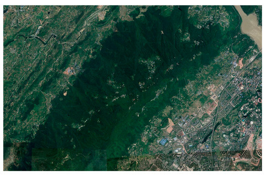
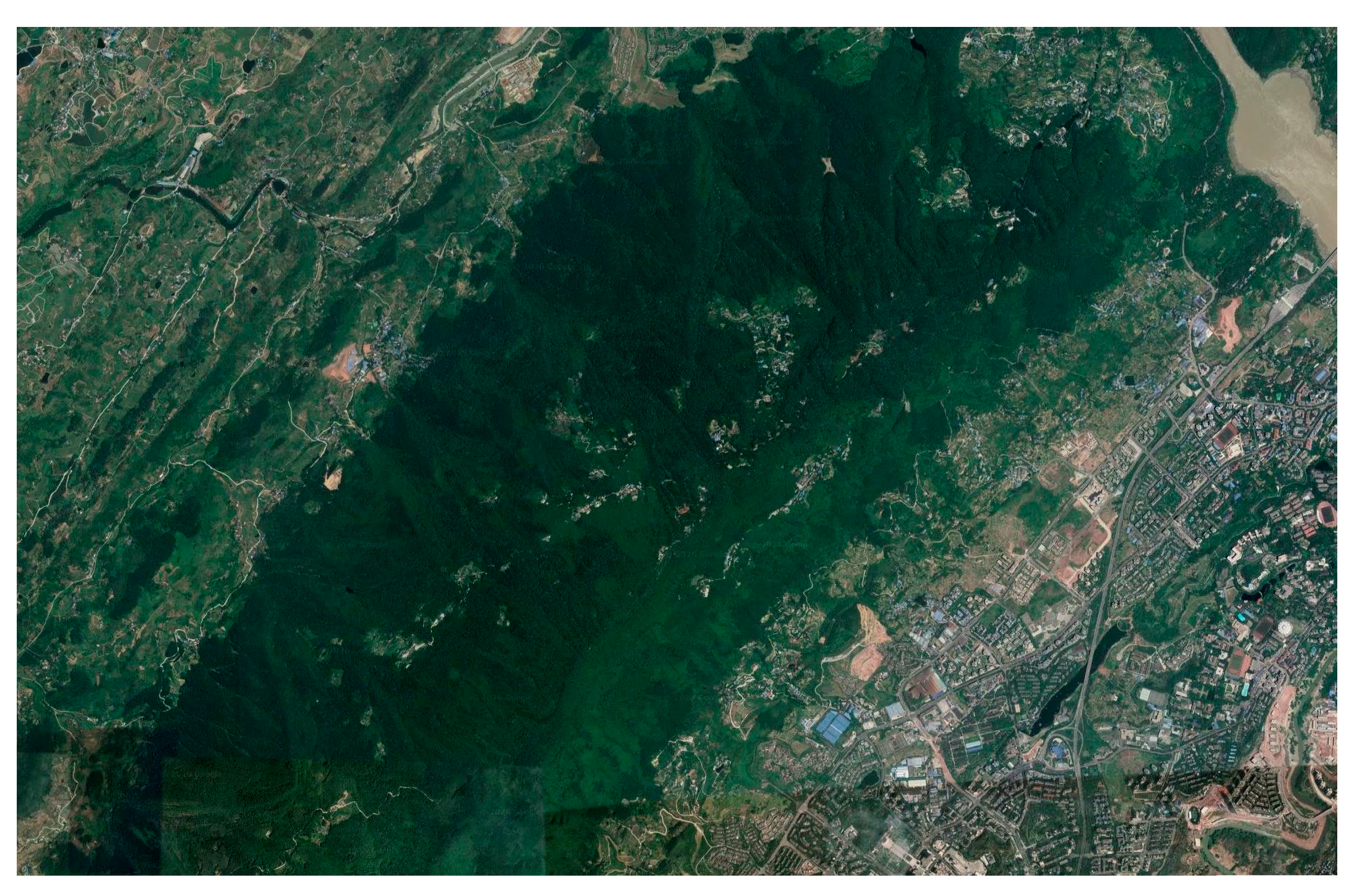
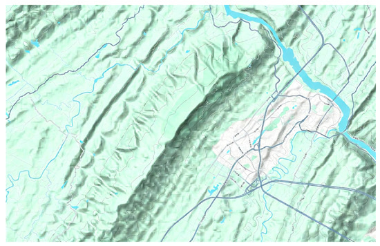
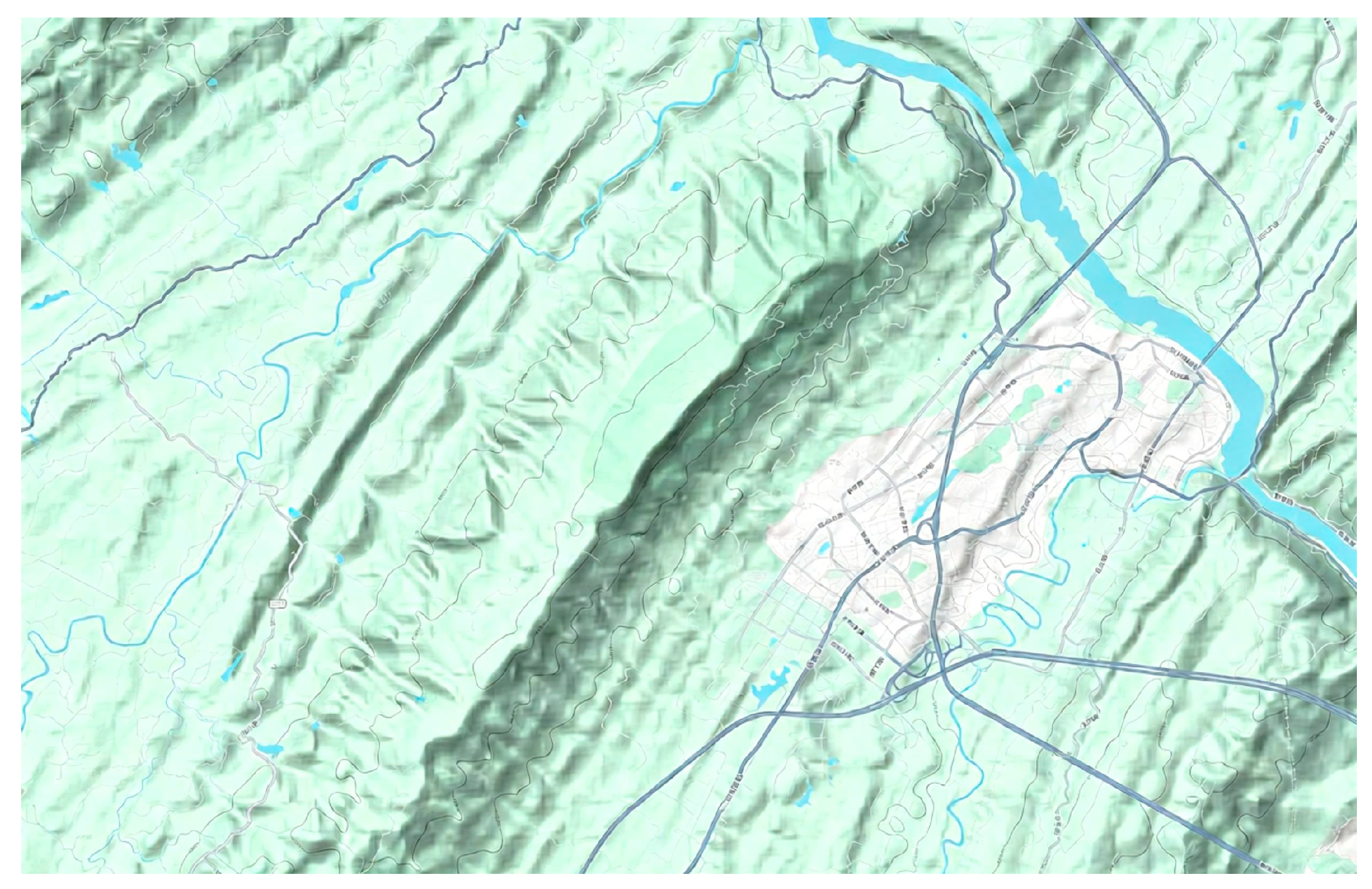
The case study was conducted in Jinyun Mountain, Chongqing (106.30° E–106.42° E, 29.77° N–29.85° N), a representative mountainous forest area characterized by rugged topography, pronounced elevation gradients, and persistent wildfire surveillance demand. Terrain elevation data were derived from the 30 m Shuttle Radar Topography Mission (SRTM) digital elevation model, while Tianditu topographic map services were used only for cartographic visualization.
The case-study dataset was assembled through a collaborative research project on integrated low-altitude transportation operation and management in Chongqing. Historical wildfire occurrence records in the Jinyun Mountain area were used to identify candidate surveillance locations, as these sites represent recurrent fire-prone areas requiring priority patrol. After data screening and spatial consolidation of overlapping records, representative monitoring nodes were established for the scheduling model.
To construct realistic meteorological scenarios, the temperature and local mountain-wind data were selected from the week preceding historical major wildfire events in Jinyun Mountain. This design reflects the environmental conditions under which preventive UAV patrol is most needed. The corresponding temperature observations were used to model battery derating, while the time-dependent mountain-wind and valley-wind conditions were incorporated into the flight-energy estimation for each UAV arc.
Candidate UAV base stations were located in relatively flat foothill areas to ensure operational feasibility for takeoff, landing, charging, and daily maintenance.
The monitoring sites considered in this study were identified based on locations with documented wildfire occurrence records. In conjunction with historical fire events and local fire-prevention management requirements, these sites were further classified into different risk levels, including high-risk and low-risk categories. This classification provides practical support for risk-differentiated patrol planning and priority-oriented task allocation.
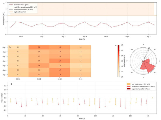
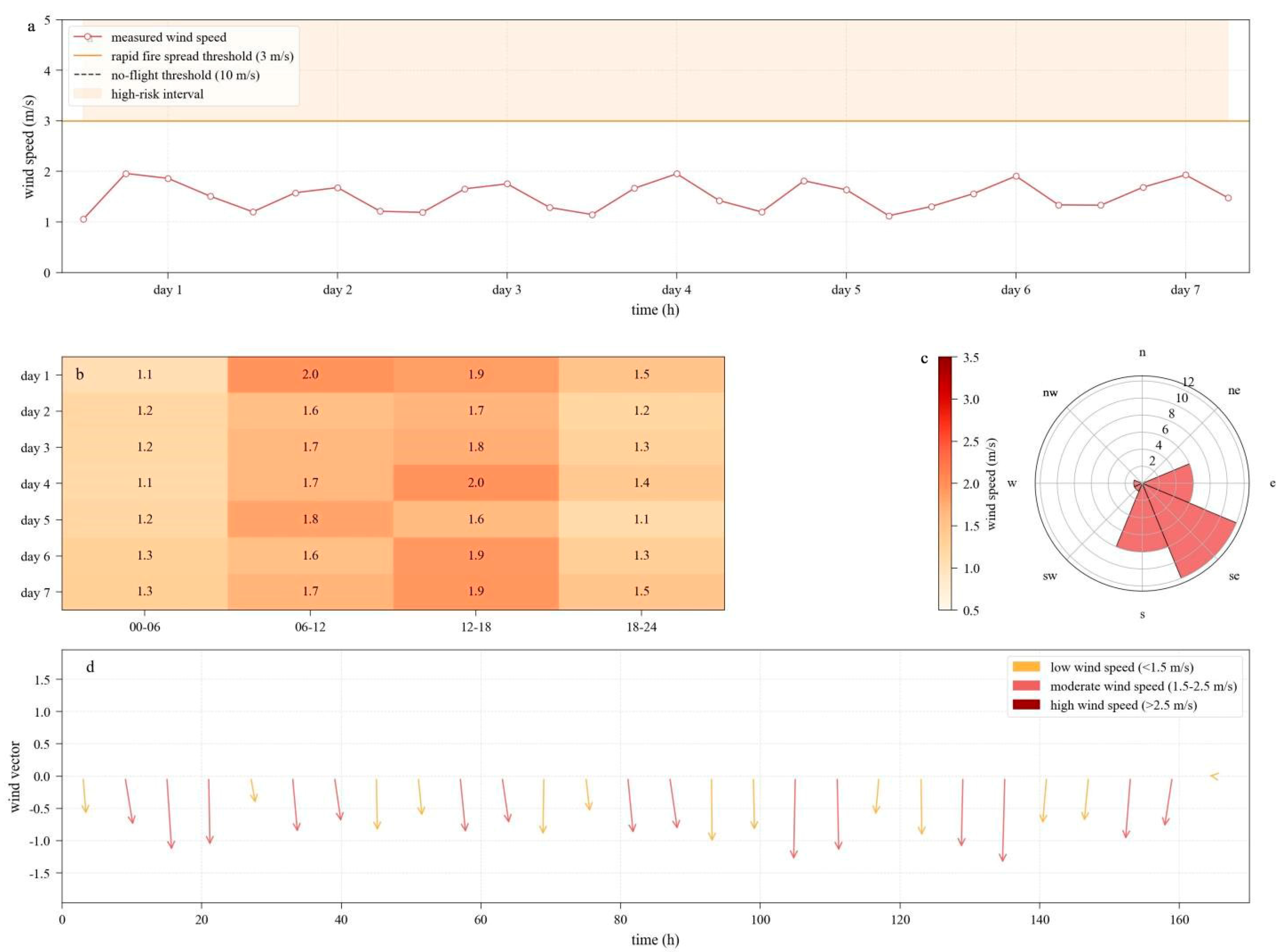
The terrain and elevation data were further used to construct the three-dimensional patrol network. In addition, micro-meteorological factors, including wind conditions and ambient temperature, were incorporated to capture the environmental variability affecting UAV operations in mountainous areas. Figure 1 presents the geographic location of the Jinyun Mountain study area, Figure 2 shows its topographic and elevation characteristics, and Figure 3 illustrates the representative wind-field and micro-meteorological conditions considered in this study.
Figure 1.
Location of the Jinyun Mountain study area.
Figure 2.
Topographic characteristics of the Jinyun Mountain study area.
Figure 3.
Representative wind-field and micro-meteorological characteristics of the study area: (a) Time series of measured wind speed. (b) Heatmap of average wind speed. (c) Wind rose diagram. (d) Wind vector plot.
3.2. Experimental Settings
Considering the pronounced diurnal variations in the mountainous microclimate in summer, four representative inspection periods were defined in the simulations: early morning (03:00), morning (09:00), afternoon high-temperature period (15:00), and nighttime (21:00). The wind speed and ambient temperature associated with each period were derived from local historical meteorological records and further generated using a Monte Carlo sampling procedure.
The fleet considered in the simulations consists of homogeneous DJI M350 RTK multirotor UAVs deployed at solar-powered base stations within the study area. Table 1 shows the relevant parameters of the UAV. The overall algorithmic framework was implemented in Python (PyCharm Community Edition 2024.1.7), and the MILP model was solved using the Branch-and-Cut method in the Gurobi optimizer. The valid inequalities developed in this study were dynamically added during the solution process through the Gurobi callback interface, and the time limit was set to 1200 s. For LNS, the maximum number of iterations was set to 5000, and a neighborhood search strategy combining random destruction and greedy repair was adopted. For ACO, the number of ants was set to 100. The ant population size was set to 100 based on preliminary calibration under the same time limit and iteration setting used in the comparative experiments. Too few ants led to insufficient search diversity, whereas too many ants increased computational overhead with limited additional benefit. Therefore, 100 was selected to achieve a practical balance between exploration capability and computational efficiency. The maximum number of iterations was set to 1000, and the pheromone parameters were configured as α = 1.0, β = 2.0, and ρ = 0.1.
Table 1.
Main technical parameters of the DJI M350 RTK UAV used in the simulations.
3.3. Routing and Dispatching Results
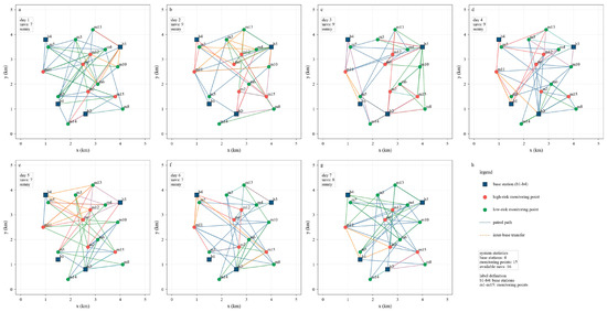
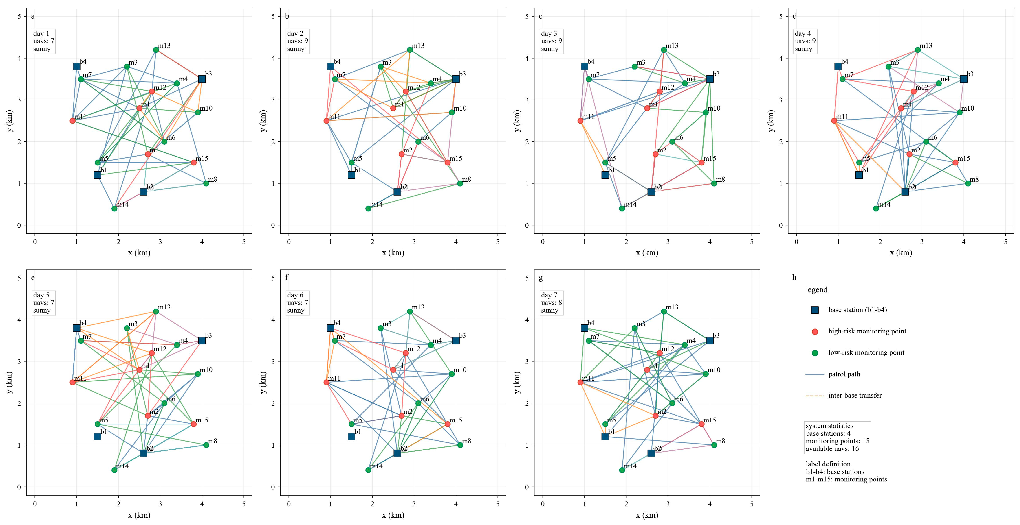
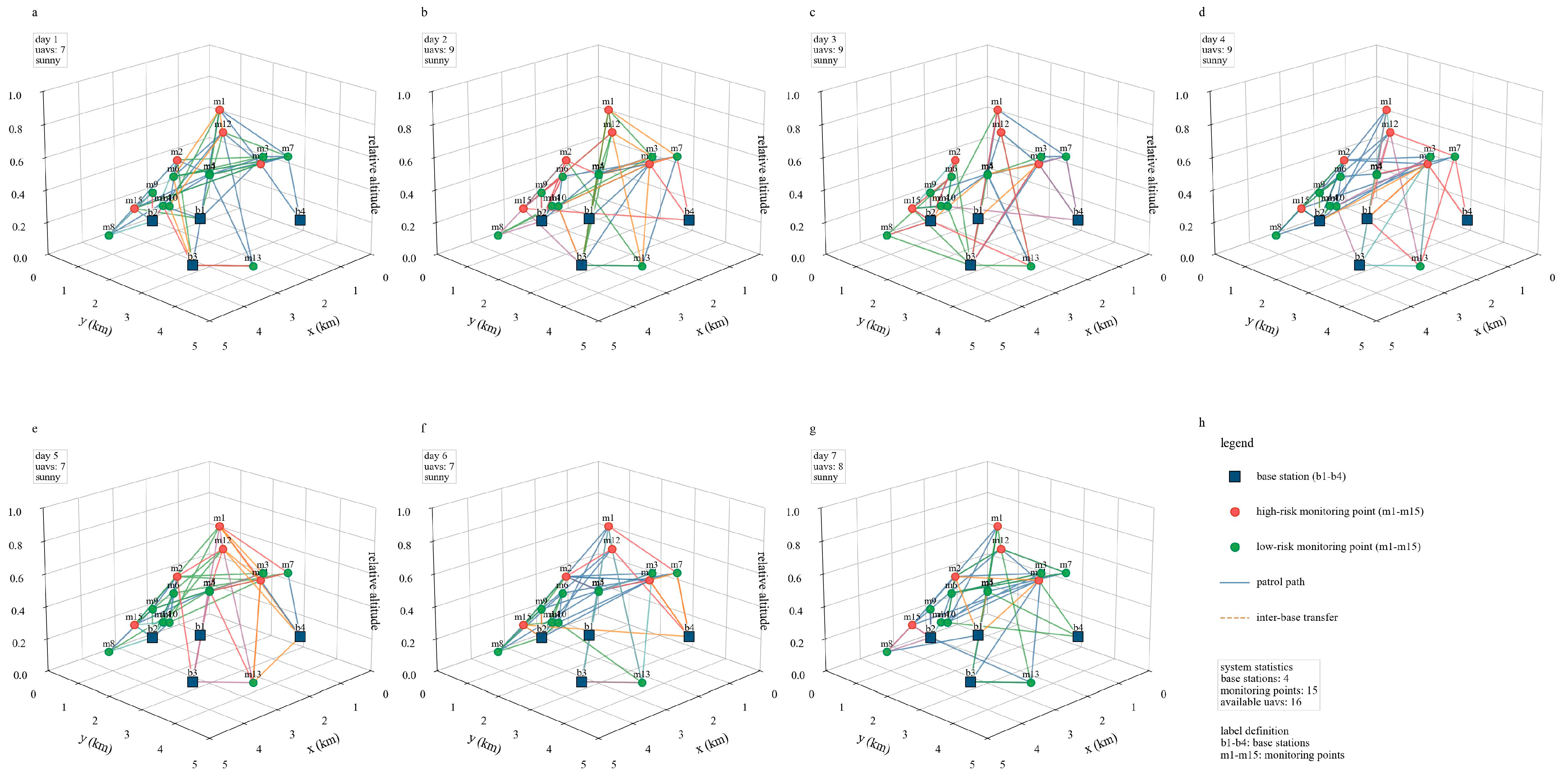
After solving the scheduling model for the Jinyun Mountain study area, the optimized UAV routing and dispatching results were obtained, as shown in Figure 4 and Figure 5.
Figure 4.
Optimized UAV routing plan in the 2D plane.
Figure 5.
Optimized UAV routing plan in the 3D terrain.
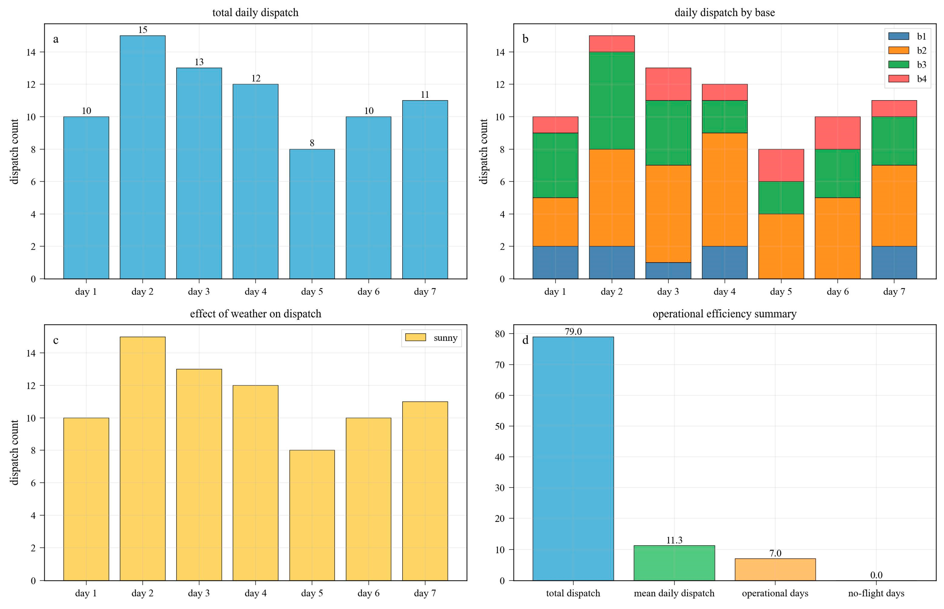
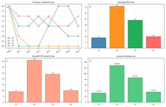
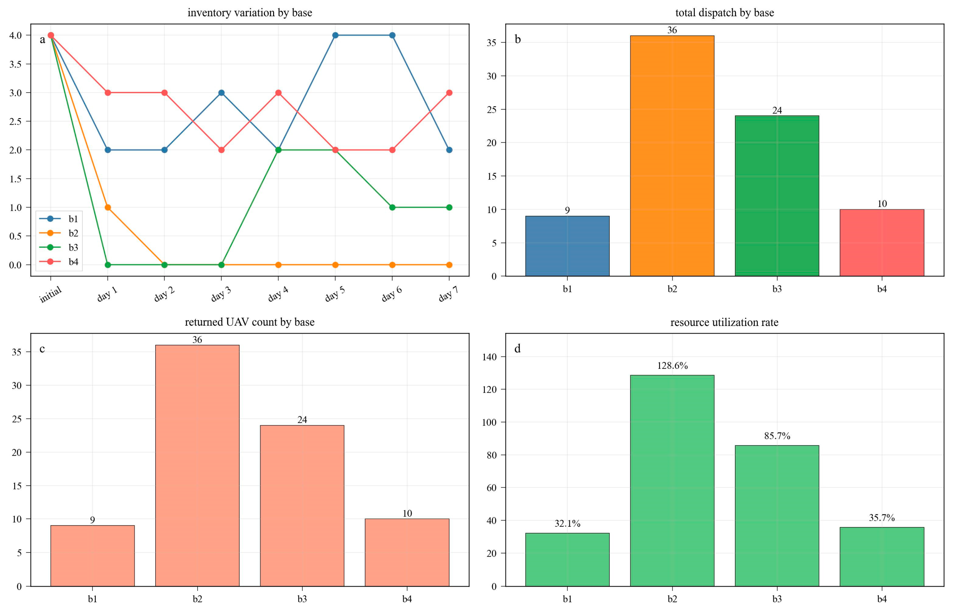
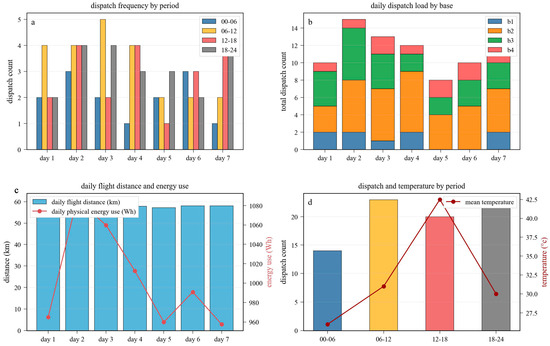
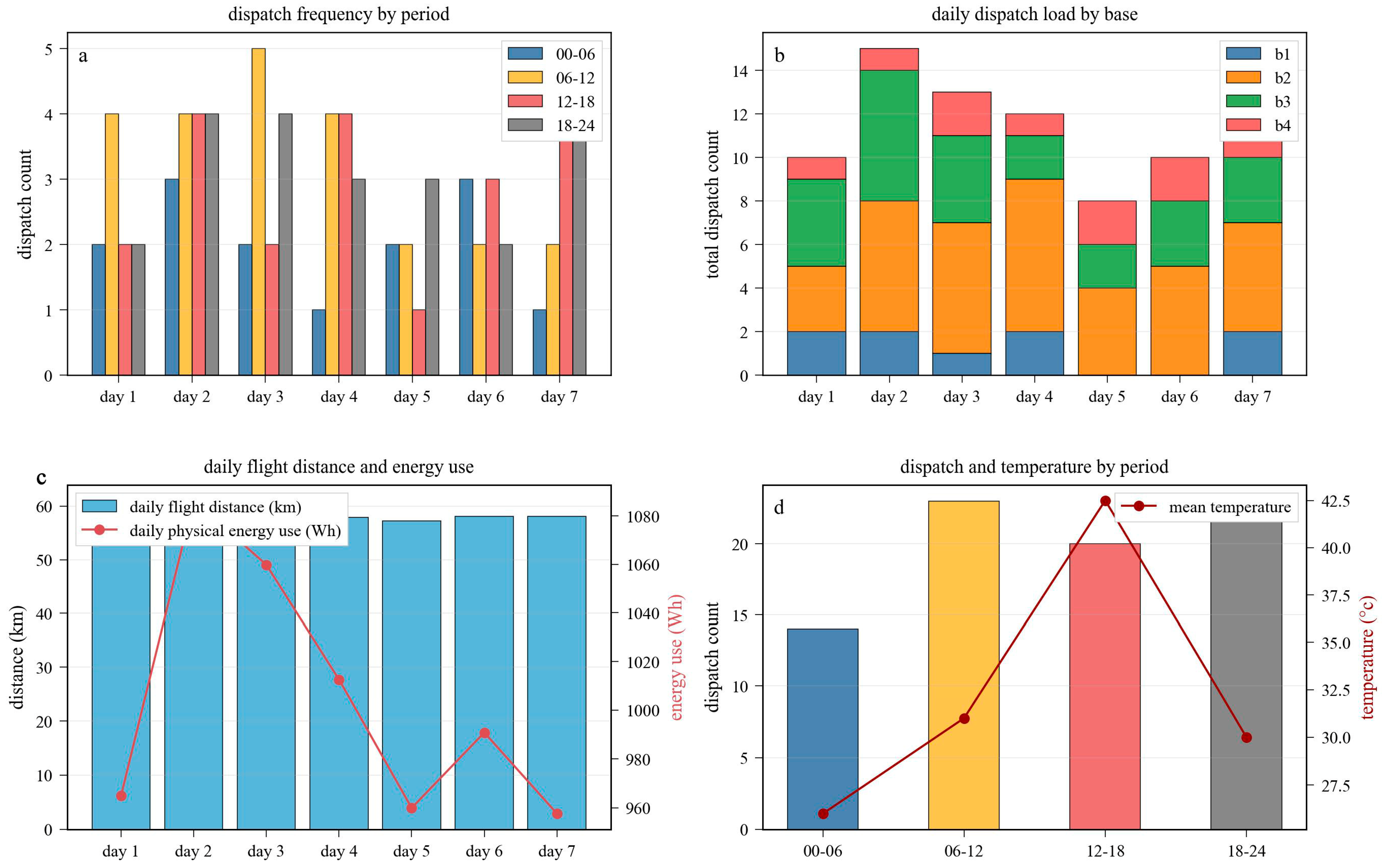
Figure 6, Figure 7 and Figure 8 further summarize the scheduling, inventory, and energy-consumption characteristics of the optimized UAV patrol scheme. Specifically, Figure 6 presents the time-period scheduling results of the UAV fleet, including the total daily dispatch, the dispatch distribution by base station, the influence of weather conditions on dispatch intensity, and the overall operational efficiency. Figure 7 shows the inventory dynamics and resource utilization at the solar-powered base stations, including the battery inventory variation, the total dispatch by base, the number of returned UAVs, and the corresponding resource utilization rates. Figure 8 illustrates the energy-consumption characteristics of the patrol missions, including the dispatch frequency in different periods, the daily dispatch load by base, the relationship between daily flight distance and energy use, and the combined variation in dispatch and temperature over time.
Figure 6.
Time-period scheduling results of the UAV fleet: (a) Total daily dispatch. (b) Daily dispatch by base. (c) Effect of weather on dispatch. (d) Operational efficiency summary.
Figure 7.
Inventory dynamics and resource utilization at solar-powered base stations: (a) Inventory variation by base. (b) Total dispatch by base. (c) Returned UAV count by base. (d) Resource utilization rate.
Figure 8.
Energy-consumption analysis of the UAV patrol missions: (a) Dispatch frequency by period. (b) Daily dispatch load by base. (c) Daily flight distance and energy use. (d) Dispatch and temperature by period.
3.4. Effect of Valid Inequalities
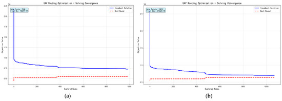
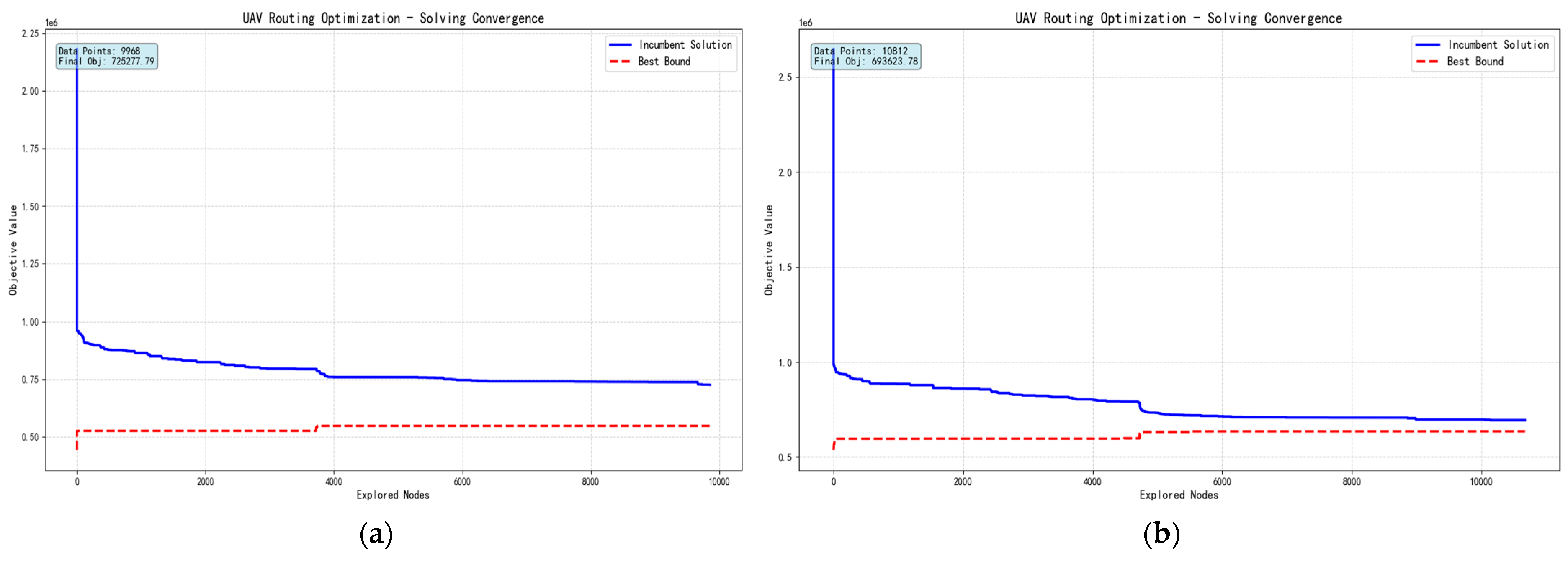
To evaluate the effectiveness of the proposed algorithmic enhancement, the convergence processes with and without the introduced valid inequalities were compared under the same time limit of 1200 s, and the corresponding results are presented in Figure 9.
Figure 9.
Convergence behavior of the branch-and-cut algorithm under different settings: (a) Convergence process without valid inequalities. (b) Convergence process with valid inequalities.
Figure 9 presents the representative summer high-risk scenario to illustrate the branch-and-cut search behavior in detail; the same valid inequalities were also tested under the autumn and winter scenarios, and similar improvements in search efficiency were observed. Although the current numerical experiments focus on three representative seasonal cases, the formulation itself remains directly applicable to year-round operations, including spring conditions, once the corresponding meteorological inputs are provided. As shown in Figure 9a, for the representative summer high-risk scenario, when no valid inequalities were introduced, task permutations among homogeneous UAVs generated a large number of symmetric equivalent solutions, which caused the search tree to expand rapidly in the early stage. Within 1200 s, the solver explored 9968 nodes; however, the best bound improved only slowly, and the incumbent solution reached 725,277.79, leaving a relatively large optimality gap.
In contrast, Figure 9b shows that the introduction of valid inequalities significantly improved the search efficiency of the algorithm. Specifically, the lower-bound cut strengthened the initial LP relaxation at the root node, while the symmetry-breaking cut reduced redundant exploration of symmetric branches. Although the total number of explored nodes remained comparable after the introduction of the cutting planes (10,812 nodes), the search process became substantially more effective. As a result, the improved algorithm obtained a better feasible integer solution within the same 1200 s time limit, achieving an objective value of 693,623.78. Similar improvements were also observed in the autumn and winter scenarios, although Figure 9 presents only the summer case as the primary high-risk and most operationally critical reference scenario. These results indicate that, across the three seasonal meteorological scenarios, the proposed valid inequalities can strengthen the relaxation, reduce redundant search, and improve scheduling performance under identical computational resources.
3.5. Comparison with Benchmark Algorithms
To evaluate the competitiveness of the proposed method under different meteorological conditions, the improved branch-and-cut algorithm was compared with LNS and ACO under the same time limit of 1200 s.
To further examine the robustness of the proposed algorithm under complex terrain and varying meteorological conditions, three groups of wind–temperature scenarios were designed. The improved Branch-and-Cut algorithm was compared with an LNS algorithm and an ACO algorithm, with the time limit for all methods uniformly set to 1200 s. The computational results are reported in Table 2.
Table 2.
Comparison of the improved branch-and-cut algorithm with LNS and ACO under different meteorological scenarios.
Table 2 shows that, after simultaneously accounting for the three-dimensional wind field and temperature-induced battery derating, the performance of the conventional heuristic algorithms became relatively weak. The main reason is that the incorporation of three-dimensional physical constraints substantially shrinks the feasible solution space, whereas LNS and ACO lack effective lower-bound mechanisms and relaxation-strengthening strategies, making them more prone to local optima. Across the three test groups, LNS required all 16 UAVs to satisfy the coverage constraints in both the first and third scenarios. The scheduling plans generated by ACO exhibited a maximum total flight distance of 812.69 km, together with a considerable amount of unnecessary detours and nonessential climbing maneuvers.
By contrast, the improved Branch-and-Cut algorithm demonstrated stronger optimization capability within the same computational time. Across the three meteorological scenarios, it consistently generated more efficient patrol schedules than LNS and ACO under the same 1200 s time limit. Compared with the two heuristic algorithms, the improved method reduced the total flight distance by approximately 36–49% and the total physical energy consumption by approximately 61–74%, while also requiring fewer UAVs to complete the same monitoring tasks. This improvement can be attributed to the ability of the proposed model to globally coordinate task allocation and route design under wind, terrain, and temperature-related energy constraints.
It should be noted that, although the MILP-based solution in Table 2 shows a slightly higher number of sorties than LNS and ACO in the second scenario, it remains significantly superior in terms of the number of activated UAVs, the total flight distance, and the total energy consumption. This difference arises because LNS and ACO tend to reduce the number of sorties by extending the length of individual routes, thereby increasing the coverage range of each UAV. However, under the coupled effects of three-dimensional terrain, dynamic wind fields, and temperature variation, such long-route strategies force UAVs to experience headwind and climbing conditions more frequently, which leads to a substantial increase in energy consumption, reaching up to 36,234.96 Wh. Under these circumstances, LNS can only compensate for the insufficient endurance of individual UAVs by activating additional UAVs. In contrast, the proposed MILP framework with valid inequalities performs a global optimization and tends to adopt a high-frequency short-range task allocation pattern, thereby controlling the depth of discharge of each flight while reducing the fleet size to 9 UAVs and significantly lowering the total energy consumption. This finding suggests that the proposed model can provide safer scheduling solutions that are better aligned with the operational characteristics of mountainous flight missions and battery constraints.
Overall, the experimental results demonstrate that, under complex physical environmental constraints, the proposed model can generate scheduling solutions that jointly balance operational safety, fleet size, and energy consumption within the same computational time budget, thereby providing useful support for multi-UA V cooperative inspection in mountainous regions.
4. Discussion
This study developed a MILP model for cooperative multi-UAV wildfire patrol in mountainous environments. The proposed model explicitly incorporates three-dimensional terrain and micro-meteorological effects into the scheduling process, specifically accounting for elevation variation, dynamic wind fields, and temperature-induced battery derating. This formulation improves the operational realism and energy feasibility of UAV deployment for monitoring tasks with different risk levels.
To address the combinatorial complexity of large-scale fleet scheduling, two classes of valid inequalities were introduced: a symmetry-breaking cut for homogeneous UAV fleets and a fleet-size lower-bound cut. These cuts were embedded into the branch-and-cut framework to improve pruning efficiency during the MILP solution process. Simulation experiments based on real geographic and meteorological data from Jinyun Mountain in Chongqing supported the effectiveness of the proposed model and solution approach.
First, the introduced valid inequalities reduced redundant symmetric nodes in the search tree and tightened the initial lower bound, thereby accelerating convergence within the prescribed time limit. Second, under the same time limit of 1200 s, the improved branch-and-cut algorithm achieved better optimization performance than the LNS and ACO algorithms under the considered physical constraints. Across the three meteorological scenarios reported in Table 2, the proposed method reduced the total flight distance by approximately 36–49% and the total physical energy consumption by approximately 61–74%, while also requiring fewer UAVs for the same patrol task.
Compared with experience-based inspection strategies and simplified routing methods that do not adequately capture physical constraints, the proposed model and solution approach provide a more practical basis for wildfire surveillance planning and emergency dispatch in mountainous areas. This study may serve as a useful methodological reference for automated early-stage wildfire reconnaissance under extreme climatic conditions and may also inform future research on UAV swarm scheduling in complex disaster scenarios. Future work will extend the proposed framework by incorporating real-time wind-field updates, multi-UAV collision-avoidance constraints, and heterogeneous UAV teams for broader disaster-response scenarios.
5. Conclusions
This study developed a MILP model for cooperative multi-UAV fire inspection in mountainous forests by explicitly incorporating three-dimensional terrain and micro-meteorological factors into the scheduling framework. Unlike conventional two-dimensional route-planning approaches, the proposed model captures elevation variation, dynamic wind fields, and temperature-induced battery derating, thereby improving the operational realism and energy feasibility of fleet deployment for monitoring tasks with different risk levels. Although the case study focuses on three representative seasonal scenarios, the proposed framework is directly extendable to year-round patrol planning when the corresponding seasonal meteorological inputs are available.
From an algorithmic perspective, two classes of valid inequalities were introduced to address the combinatorial complexity of large-scale fleet scheduling: a symmetry-breaking cut for homogeneous UAV fleets and a fleet-size lower-bound cut. These inequalities were embedded into a branch-and-cut framework to improve pruning efficiency during the MILP solution process. Simulation experiments based on real geographic and meteorological data from Jinyun Mountain in Chongqing demonstrated the effectiveness of the proposed model and solution approach.
The results indicate that the introduced valid inequalities reduce redundant symmetric nodes in the relaxation tree and strengthen the initial lower bound, thereby accelerating convergence within the prescribed time limit. Under the same solving time limit of 1200 s, the improved branch-and-cut algorithm achieved better optimization performance than the LNS and ACO algorithms under the considered physical constraints. In particular, across the three meteorological scenarios considered in this study, the improved branch-and-cut algorithm reduced the total flight distance by approximately 36–49% and the total physical energy consumption by approximately 61–74% compared with LNS and ACO, while also requiring fewer UAVs to complete the same inspection tasks.
Compared with inspection strategies that rely heavily on manual experience or simplified routing methods that do not adequately account for physical constraints, the proposed model and solution approach provides a more practical basis for wildfire surveillance planning and emergency dispatch in mountainous areas. This study may serve as a useful methodological reference for automated early-stage wildfire reconnaissance in mountainous regions under extreme climatic conditions and may also inform future research on UAV swarm scheduling in complex disaster scenarios.
Author Contributions
Conceptualization, J.Z.; methodology, J.Z.; software, A.S.; validation, A.S.; formal analysis, J.Z.; investigation, J.Z.; resources, J.Z.; data curation, J.Z.; writing—original draft preparation, J.Z.; writing—review and editing, A.S.; visualization, A.S.; supervision, J.Z.; project administration, B.L.; funding acquisition, J.Z. All authors have read and agreed to the published version of the manuscript.
Funding
This research received no external funding.
Data Availability Statement
Data are contained within the article. The raw data are not publicly available due to privacy restrictions.
Conflicts of Interest
The authors declare no conflict of interest.
Abbreviations
The following abbreviations are used in this manuscript:
| UAV | Unmanned Aerial Vehicle |
| MILP | Mixed-Integer Linear Programming |
| LNS | Large Neighborhood Search |
| ACO | Ant Colony Optimization |
Appendix A
Table A1.
Model Variables and Parameters.
References
- Giglio, L.; Randerson, J.T.; Van Der Werf, G.R. Analysis of Daily, Monthly, and Annual Burned Area Using the Fourth-generation Global Fire Emissions Database (GFED4). JGR Biogeosci. 2013, 118, 317–328. [Google Scholar] [CrossRef] [Scilit]
- Zheng, Y.; Zhang, G.; Tan, S.; Feng, L. Research on Progress of Forest Fire Monitoring with Satellite Remote Sensing. Agric. Rural. Stud. 2023, 1, 14. [Google Scholar] [CrossRef] [Scilit]
- Saffre, F.; Hildmann, H.; Karvonen, H.; Lind, T. Monitoring and Cordoning Wildfires with an Autonomous Swarm of Unmanned Aerial Vehicles. Drones 2022, 6, 301. [Google Scholar] [CrossRef] [Scilit]
- Partheepan, S.; Sanati, F.; Hassan, J. Autonomous Unmanned Aerial Vehicles in Bushfire Management: Challenges and Opportunities. Drones 2023, 7, 47. [Google Scholar] [CrossRef] [Scilit]
- Davies, D.K.; Ilavajhala, S.; Wong, M.M.; Justice, C.O. Fire Information for Resource Management System: Archiving and Distributing MODIS Active Fire Data. IEEE Trans. Geosci. Remote Sens. 2009, 47, 72–79. [Google Scholar] [CrossRef] [Scilit]
- Field, R.D.; Spessa, A.C.; Aziz, N.A.; Camia, A.; Cantin, A.; Carr, R.; De Groot, W.J.; Dowdy, A.J.; Flannigan, M.D.; Manomaiphiboon, K.; et al. Development of a Global Fire Weather Database. Nat. Hazards Earth Syst. Sci. 2015, 15, 1407–1423. [Google Scholar] [CrossRef] [Scilit]
- Qin, X.L.; Li, X.T.; Liu, S.C.; Liu, Q.; Li, Z.Y. Forest Fire Early Warning and Monitoring Techniques Using Satellite Remote Sensing in China. J. Remote Sens. 2020, 24, 511–520. (In Chinese) [Google Scholar] [CrossRef] [Scilit]
- Bharany, S.; Sharma, S.; Frnda, J.; Shuaib, M.; Khalid, M.I.; Hussain, S.; Iqbal, J.; Ullah, S.S. Wildfire Monitoring Based on Energy Efficient Clustering Approach for FANETS. Drones 2022, 6, 193. [Google Scholar] [CrossRef] [Scilit]
- Duan, H.; Yu, Y.; Zhang, X.; Shao, S. Three-Dimension Path Planning for UCAV Using Hybrid Meta-Heuristic ACO-DE Algorithm. Simul. Model. Pract. Theory 2010, 18, 1104–1115. [Google Scholar] [CrossRef] [Scilit]
- Du, P.; Shi, Y.; Cao, H.; Garg, S.; Alrashoud, M.; Shukla, P.K. AI-Enabled Trajectory Optimization of Logistics UAVs With Wind Impacts in Smart Cities. IEEE Trans. Consum. Electron. 2024, 70, 3885–3897. [Google Scholar] [CrossRef] [Scilit]
- Faessler, M.; Franchi, A.; Scaramuzza, D. Differential Flatness of Quadrotor Dynamics Subject to Rotor Drag for Accurate Tracking of High-Speed Trajectories. IEEE Robot. Autom. Lett. 2018, 3, 620–626. [Google Scholar] [CrossRef] [Scilit]
- Li, N.; Liu, X.; Yu, B.; Li, L.; Xu, J.; Tan, Q. Study on the Environmental Adaptability of Lithium-Ion Battery Powered UAV under Extreme Temperature Conditions. Energy 2021, 219, 119481. [Google Scholar] [CrossRef] [Scilit]
- Li, H.; Zhan, Z.; Wang, Z. Energy-consumption Model for Rotary-wing Drones. J. Field Robot. 2024, 41, 1940–1959. [Google Scholar] [CrossRef] [Scilit]
- Wang, J.-Y.; Luo, B.; Zeng, M.; Meng, Q.-H. A Wind Estimation Method with an Unmanned Rotorcraft for Environmental Monitoring Tasks. Sensors 2018, 18, 4504. [Google Scholar] [CrossRef] [Scilit] [PubMed]
- Ryu, H.; Lee, C.; Park, Y.; Rhudy, M.B.; Lee, D.; Jang, D.; Youn, W. In-Flight Estimation of Drag Parameters and Air Data for Unmanned Aircraft. J. Aerosp. Inf. Syst. 2022, 19, 166–178. [Google Scholar] [CrossRef] [Scilit]
- Sadati, İ. An Efficient Matheuristic Integration with Benders Decomposition for Unmanned Aerial Vehicle Routing Problem in Forest Fire Surveillance. Comput. Ind. Eng. 2025, 204, 111087. [Google Scholar] [CrossRef] [Scilit]
- Huang, Y.; Chen, J.; Wang, H.; Su, G. A Method of 3D Path Planning for Solar-Powered UAV with Fixed Target and Solar Tracking. Aerosp. Sci. Technol. 2019, 92, 831–838. [Google Scholar] [CrossRef] [Scilit]
- McNeely, R.L.; Iyer, R.V.; Chandler, P.R. Tour Planning for an Unmanned Air Vehicle Under Wind Conditions. J. Guid. Control Dyn. 2007, 30, 1299–1306. [Google Scholar] [CrossRef] [Scilit]
- Duan, M.; Lu, M.; Jin, H. PIDNN: A Hybrid Intelligent Prediction Model for UAV Battery Degradation. Batteries 2026, 12, 124. [Google Scholar] [CrossRef] [Scilit]
- Letchford, A.N.; Salazar-González, J.-J. Stronger Multi-Commodity Flow Formulations of the Capacitated Vehicle Routing Problem. Eur. J. Oper. Res. 2015, 244, 730–738. [Google Scholar] [CrossRef] [Scilit]
- Hajkarim, S.M.H.; Sujit, P.B.; Menon, P.P. Optimized Mission Planning for Heterogeneous Uncrewed Vehicle Teams. IEEE Access 2024, 12, 147387–147399. [Google Scholar] [CrossRef] [Scilit]
- Tamke, F.; Buscher, U. A Branch-and-Cut Algorithm for the Vehicle Routing Problem with Drones. Transp. Res. Part B Methodol. 2021, 144, 174–203. [Google Scholar] [CrossRef] [Scilit]
- Hosseini Dolatabadi, S.H.; Bhuiyan, T.H.; Kaleem, W.; Subramanyam, A.; Cokyasar, T. A Branch-and-Cut Algorithm for Routing a Heterogeneous Drone-Ground Vehicle Fleet to Deliver Time-Sensitive Products. Transp. Res. Part C Emerg. Technol. 2026, 183, 105454. [Google Scholar] [CrossRef] [Scilit]
- Franco, J.L.; Curtis, V.V.; Senne, E.L.F.; Verri, F.A.N. An Exact Method and a Heuristic for Last-Mile Delivery Drones Routing with Centralized Graph-Based Airspace Control. Comput. Oper. Res. 2025, 178, 107006. [Google Scholar] [CrossRef] [Scilit]
- Husseinzadeh Kashan, A.; Ozturk, O. Improved MILP Formulation Equipped with Valid Inequalities for Scheduling a Batch Processing Machine with Non-Identical Job Sizes. Omega 2022, 112, 102673. [Google Scholar] [CrossRef] [Scilit]
- Yin, Y.; Li, D.; Wang, D.; Ignatius, J.; Cheng, T.C.E.; Wang, S. A Branch-and-Price-and-Cut Algorithm for the Truck-Based Drone Delivery Routing Problem with Time Windows. Eur. J. Oper. Res. 2023, 309, 1125–1144. [Google Scholar] [CrossRef] [Scilit]
- Xia, Y.; Zeng, W.; Zhang, C.; Yang, H. A Branch-and-Price-and-Cut Algorithm for the Vehicle Routing Problem with Load-Dependent Drones. Transp. Res. Part B Methodol. 2023, 171, 80–110. [Google Scholar] [CrossRef] [Scilit]
- Schermer, D.; Moeini, M.; Wendt, O. A Hybrid VNS/Tabu Search Algorithm for Solving the Vehicle Routing Problem with Drones and En Route Operations. Comput. Oper. Res. 2019, 109, 134–158. [Google Scholar] [CrossRef] [Scilit]
- Meng, S.; Chen, Y.; Li, D. The Multi-Visit Drone-Assisted Pickup and Delivery Problem with Time Windows. Eur. J. Oper. Res. 2024, 314, 685–702. [Google Scholar] [CrossRef] [Scilit]

Disclaimer/Publisher’s Note: The statements, opinions and data contained in all publications are solely those of the individual author(s) and contributor(s) and not of MDPI and/or the editor(s). MDPI and/or the editor(s) disclaim responsibility for any injury to people or property resulting from any ideas, methods, instructions or products referred to in the content. |
© 2026 by the authors. Licensee MDPI, Basel, Switzerland. This article is an open access article distributed under the terms and conditions of the Creative Commons Attribution (CC BY) license.