- Article

Baited-Associated Aggregation of Spinner Sharks in Hulhumale, Maldives: Preliminary Observations and Photo-Identification Tools
- Francesca Romana Reinero,
- Marco Pireddu and
- Primo Micarelli
- + 4 authors
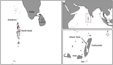
The spinner shark is a widely distributed coastal species that faces significant anthropogenic pressures, yet information on its ecology in the western Indian Ocean remains poorly documented. This study provides preliminary baseline observations on temporal occurrence, sex ratio, and size distribution of a bait-attracted spinner shark aggregation in Hulhumale (North Malé Atoll, Maldives) and presents the first individual-level photo-identification (photo-ID) catalogue for the species based on underwater observations. Surveys were conducted in November 2024 and November 2025 using underwater photography, video recordings, and laser photogrammetry. In total, 69 individual spinner sharks were identified using the standard photo-ID protocol which proved to be valid. On the contrary, the preliminary application of the semi-automatic Identifin software indicated possible effectiveness for individual recognition; however, its performance cannot be reliably validated in this area because of poor image quality and environmental turbidity. Six individuals were re-sighted across years, demonstrating the feasibility of non-invasive repeated, long-term monitoring through photo-ID. Although interannual variation in sex ratio of sharks observed was detected (χ2 = 10.56, p = 0.0012), this pattern should be interpreted cautiously due to provisioning-related sampling bias and unequal sampling effort across years. Total length measurements (n = 28) indicated predominantly adult and subadult individuals, with no apparent interannual differences in size distributions. Overall, this study establishes a methodological baseline for spinner shark photo-ID in the Maldives and highlights the importance of multi-year and multi-season monitoring to robustly evaluate aggregation dynamics, site fidelity, and population-level patterns in this region.
2 March 2026
![Bathymetry (shading) and main surface currents (arrows) of the Bering Sea and surrounding waters. Numbers indicate main geographical objects and currents: (1) Sea of Okhotsk, (2) Kamchatka Peninsula, (3) Komandorski (Commander) Basin, (4) Aleutian Basin, (5) Bowers Basin, (6) Gulf of Anadyr and Anadyr Current, (7) Chukchi Sea, (8) Aleutian Islands, (9) Bristol Bay, (10) Gulf of Alaska, (11) North Kuril Current, (12) West Kamchatka Current, (13) East Kamchatka Current, (14) Siberian Coastal Current, (15) Beaufort Gyre, (16) Bering Slope Current, (17) Alaskan Coastal Current, (18) Alaskan Stream. Currents are based on generalization of [14,33]. Bathymetry is generalized based on GEBCO_2023.](https://mdpi-res.com/cdn-cgi/image/w=281,h=192/https://mdpi-res.com/oceans/oceans-07-00021/article_deploy/html/images/oceans-07-00021-ag-550.jpg)
![A sample of the species Bathynomus pelor which was caught in a baited trap from an oil rig on the NW Shelf of Australia [5]: (A) lateral view, (B) ventral view, (C) dorsal view, (D) ventral view.](https://mdpi-res.com/cdn-cgi/image/w=281,h=192/https://mdpi-res.com/oceans/oceans-07-00020/article_deploy/html/images/oceans-07-00020-g001-550.jpg)
![Bathymetric map of the Arabian Sea showing atmospheric circulation during the (a) southwest monsoon and (b) Northeast monsoon. The location of ODP site 721A (16°40.636′ N, 59°51.879′ E) is marked by a red circle. The bold arrow indicates the position of the Findlater Jet, and additional arrows show the dominant wind directions for each season. The dashed yellow line represents the position of the ITCZ during summer. Additional cores used for comparison are marked by white circles. SL167 (22°37.15′ N, 59°41.49′ E; 774 m water depth) [38]; SO-136 KL (SO90-136KL (23°07′0.80″ N, 66°30′0.98″ E, 568 m water depth) [39]; RC-2761 (16°37′0.50″ N, 59°51′0.70″ E; 1893 water depth); RC-2724 (17°43′0.10″ N, 57°49′.20″ E; 1416 m water depth) [40]; NAST (19°59.9′ N 65°41.0′ E; 3167 m water depth) [41]. ODP site 723 (18°3.79′ N, 57°36.61′ E) [42]. (c,d) Seasonal chlorophyll-a concentration (mg m−3) derived from MODIS-Aqua Level 3 climatology highlighting phytoplankton distribution during the (c) SW monsoon and (d) NE monsoon.](https://mdpi-res.com/cdn-cgi/image/w=281,h=192/https://mdpi-res.com/oceans/oceans-07-00019/article_deploy/html/images/oceans-07-00019-g001-550.jpg)