


Abstract
Large-scale landscape transformation in mountainous regions during the Late Iron Age remains insufficiently integrated into broader debates on European urbanism. In southwestern Transylvania, extensive slope terracing came to define the spatial core of the Dacian political centre. This study examines the scale, organization, and social implications of this engineered landscape using high-resolution LiDAR data and spatial modelling. Over 4000 anthropogenic terraces were identified, and their spatial patterning was analysed through Kernel Density Estimation (300 m and 800 m radii) in order to evaluate intensity gradients and territorial articulation. The results indicate compact nuclei of high terrace concentration embedded within a broader, yet continuous, system structured along ridge corridors and circulation routes. The spatial correlation between terrace density and elevated architectural features suggests differentiated building practices and hierarchical organization within a territorially extensive settlement pattern. Rather than representing isolated fortified sites, the Dacian mountain core emerges as an integrated and infrastructurally connected landscape. These findings support the interpretation of the area as a form of Late Iron Age low-density urbanism, in which habitation, mobility, and social differentiation were materially embedded in large-scale topographic modification.
1. Introduction
Mountain landscapes have long been interpreted, especially within modern and urban-centred historiographical traditions, as marginal spaces: difficult to inhabit, poorly integrated, and resistant to large-scale political and economic centralization. In Fernand Braudel’s structural vision of historical geography, upland regions appear as spaces governed by slow rhythms and limited historical agency, in contrast to plains and major corridors of circulation (Braudel, 1949).
Such perspectives have contributed to a persistent bias in which mountain regions are implicitly treated as peripheral to political power, economic innovation, and urban development. Recent archaeological research has increasingly challenged this view. Drawing on archaeological and ethnographic evidence, Orengo (2023) argues that the marginalization of mountain environments is largely a modern construct, rooted in urban lifestyles, contemporary economic assumptions, and selective research agendas. Rather than isolated or backward, mountain communities were often deeply embedded within broader social, economic, and political networks, exploiting environmental diversity to develop resilient and highly specialized land-use systems.
Within this broader reassessment, the Șureanu Mountains (south-western Transylvania, present-day Romania) occupy a singular and transformative position in Iron Age Europe, providing a direct empirical contradiction to the model of the mountain-as-periphery. This region hosted Sarmizegetusa Regia, a major centre incorporating certain Hellenistic architectural elements within a distinct local framework, which functioned as the capital and primary political, military, and symbolic centre of the Dacian Kingdom during the Late Iron Age (Florea, 2010; Stefan, 2001). Contrary to the traditional view of mountains as peripheral spaces, the nucleus of the Dacian state emerged and thrived within a rugged highland environment, transforming the Șureanu massif into the logistical, economic, and ideological heart of a territorially expansive polity.
From the late 2nd century BC through the early 2nd century AD, this mountainous environment was not merely occupied but profoundly re-engineered into an intensively inhabited and highly structured landscape. Through systematic terracing, the construction of extensive ridge-based road networks, and the seamless integration of residential, productive, religious, and political zones, the Șureanu massif appears as the core of a complex territorial system.
This article examines the anthropogenic transformation of the region, focusing on terracing as a primary spatial strategy through which the Dacians reshaped the terrain. The core of this study is based on the identification and analysis of over 4000 anthropogenic terraces, a figure that provides a new empirical baseline for understanding the scale of Dacian landscape engineering. While this number reflects the current extent and resolution of available LiDAR datasets, and should therefore be regarded as a minimum estimate pending higher-density coverage and systematic ground verification, it nevertheless marks a substantial expansion of the documented anthropogenic footprint. The reassessment presented here has been made possible by the application of LiDAR technology, which allows the detection of subtle topographic modifications beneath dense forest cover. Combined with archaeological data and Kernel Density Estimation (KDE) analysis, these spatial datasets reveal a scale of intervention that significantly reshapes previous interpretations.
The findings invite a fundamental reconsideration of Dacian settlement organization and demographic potential. By situating the Șureanu Mountains as a sophisticated model of human–environment interaction, this study challenges traditional definitions of ‘centrality’ in the European Iron Age. It demonstrates that political and urban cores did not emerge exclusively in accessible lowland corridors; they could also be forged within high-altitude environments through the systematic, large-scale engineering of the landscape.
2. Geomorphological and Environmental Setting of the Șureanu Mountains
The Șureanu Mountains are situated in southwestern Transylvania, forming a transitional sector of the Southern Carpathians. Bounded by the Mureș River to the north and the Strei River to the west, the massif occupies a geomorphological interface between the Transylvanian basin and the higher units of the Southern Carpathians (Figure 1). Unlike the fragmented and abrupt topography typical of other Carpathian ranges, the Șureanu massif constitutes a relatively coherent morphostructural unit, a factor that proved particularly favourable for sustained and intensive human occupation.
Figure 1.
Geomorphological setting of the Șureanu Mountains. Main panel: hillshade relief model of the massif and surrounding valleys and mountain units. Inset: location of the study area within southeastern Europe.
Geologically, the massif is dominated by metamorphic formations, primarily mica schists and paragneisses, with Mesozoic limestone units occurring in the southern sector. This lithological composition significantly facilitated the large-scale anthropogenic transformations of the Iron Age. The mica schists offered high resistance to mass movement and favoured the development of thick, stable alteration mantles. Such stable slopes provided a suitable substrate for systematic terracing, allowing for the creation of level habitation surfaces that remain preserved today—conditions that would have been considerably more difficult to achieve on more erodible or unstable terrains.
From a geomorphological perspective, the landscape is defined by a succession of broad erosion surfaces developed through multiple denudation cycles, organized into three distinct morphostructural levels that influenced the spatial logic of Dacian occupation (Figure 2). The peripheral level, situated between 700 and 1200 m, represents the most intensively anthropized sector, where moderately inclined surfaces and deep, fertile soil profiles hosted the highest density of permanent settlement and the most extensive terracing projects. Above this belt, between 1200 and 1600 m, the relief transitions into elongated, wide ridges with a plateau-like appearance that functioned as corridors for movement and hosted temporary or seasonal occupations. The highest surfaces, reaching above 1600 m and up to 2000 m, consist of broad, gently modelled platforms forming the main orographic axis of the massif, along which the principal ridge-crest routes developed. While these upper zones were also used for seasonal pastoral activities, their role as high-altitude circulation corridors was structurally decisive for the integration of the massif.
Figure 2.
Ridge morphology and high-altitude circulation routes in the Șureanu Mountains: (a) Luncani platform (c. 900 m a.s.l.), illustrating broad denudation surfaces and dispersed habitation; (b) Meleia ridge (c. 1400 m a.s.l.), an example of a ridge-crest route functioning as a high-altitude corridor; (c) Mlăcile ridge (c. 1800 m a.s.l.), showing the upper morphostructural level characterized by plateau-like relief and longitudinal connectivity.
The relief rises progressively from the surrounding depressions toward the interior, with a main orographic axis extending for over 20 km, from which numerous secondary ridges branch outward. This creates a dense, radial network of crest lines and flattened ridges that functioned as natural corridors or ridge-crest routes (“drumuri de plai“), often reaching elevations exceeding 2000 m and effectively transforming the mountain into a highly connected space rather than an isolated barrier.
At a micro-morphological scale, the landscape is dominated by rounded crests and articulated slopes rather than steep scarps, favouring the development of deep, well-drained soil profiles that provided suitable conditions for both agricultural production and monumental construction. Furthermore, the hydrological structure ensures water availability throughout the massif, as the thick alteration crusts act as aquifers feeding springs at multiple elevations, allowing even the highest settlements and transit routes to remain connected to reliable water sources (Badea & Buza, 1993).
The habitability of the Șureanu massif was further supported by a substantial local resource base (Daicoviciu et al., 1989). The geology includes iron-bearing formations, while extensive timber reserves constituted a critical component of Dacian construction practices and metallurgical production. The remarkable concentration of metallurgical workshops documented around the Dacian capital suggests that the region developed into one of the most significant ironworking centres in temperate Europe during the Late Iron Age (Iaroslavschi & Mateescu, 2008). Combined with fertile soils and high-altitude pastures, these resources contributed significantly to the sustainability of long-term occupation in the massif.
At the same time, the mountain zone was not economically isolated. While small-scale, subsistence-level cultivation was likely practiced on suitable terraces and slopes, the viability of the high-altitude centre depended on integration with the surrounding lowland valleys, which provided agricultural surplus and complemented local production.
Collectively, these environmental conditions and resource distributions created a structurally favourable setting for the emergence of a territorially integrated centre of power and for the large-scale landscape engineering that characterized the Dacian occupation of the massif.
3. Historical Framework
The Dacians and Getae occupied, broadly speaking, the territory of present-day Romania and adjacent regions during the Late Iron Age. Although designated by different ethnonyms in Greek and Roman written sources, the Dacians and Getae were closely associated by ancient authors, who variously described them as speaking the same language, treated their names as interchangeable, or presented the Dacians as a branch of the Getae (Strabo, Geogr. 7.3.13; Plin., HN 4.80; Iust. 32.3.16; Cass. Dio 67.6.2).
During the 4th and 3rd centuries BC, the main centres of Getic political and economic power documented archaeologically were concentrated predominantly in the extra-Carpathian regions, especially in the Lower Danube area and east of the Carpathians (Sîrbu, 2004).
In the 2nd century BC, however, the regional balance began to change profoundly. Celtic groups, which had dominated the intra-Carpathian area (Transylvania) during the preceding centuries, gradually retreated or disappeared, while new warrior elites of northern Balkan origin penetrated the region and contributed to a major reconfiguration of its political, military, and social structures. These developments created the conditions for the emergence of new Dacian centres of power in the intra-Carpathian area (Rustoiu, 2018). At the same time, the Dacian world remained open to Hellenistic influence, which played an important role in the formation of the new political structures and later became visible in the monumental architecture and building techniques of the emerging centres of power. (Stefan, 2008; Strobel, 2019).
In the first half of the 1st century BC, King Burebista unified a large number of Dacian and Getic communities into a kingdom that became one of the major powers of southeastern Europe (Lica, 2000). Under his rule, this kingdom reached its maximum territorial extent, stretching from the Middle Danube and the Carpathian Basin to the Black Sea, and from the northern Balkans to the eastern Carpathians and beyond (Figure 3). It was within this broader context of political centralization that the Șureanu Mountains emerged as the core of the kingdom, culminating in the development of the capital, Sarmizegetusa Regia, and the associated mountain settlement system.
Figure 3.
Approximate maximum extent of Burebista’s sphere of power in the mid-1st century BC.
The emergence of this intra-Carpathian centre of power was rooted in the political transformations of the 2nd–1st centuries BC and the Hellenistic orientation of the Dacian world. From the late 1st century BC onward, Roman expansion toward the Lower Danube, together with repeated military interventions, diplomatic relations, and frontier policies, increasingly shaped the strategic environment in which this centre further developed during the 1st century AD (Lica, 2000). This historical trajectory culminated under King Decebalus and ended with Trajan’s conquest of the Dacian capital in the early 2nd century AD.
Within the Șureanu massif itself, this broader historical process can be traced in several successive stages. Initially, Dacian occupation was concentrated primarily on the lower fringes of the massif, where early fortifications such as those at Costești-Cetățuie, Alun–Piatra Roșie, Cugir and Tilișca were established. These sites represent the first major peaks of Dacian landscape engineering; at Piatra Roșie, the entire hilltop was levelled and the eastern slope was systematically transformed into massive stepped terraces (Pețan, 2021). Far from being isolated outposts, these fortifications were surrounded by terraced settlements, demonstrating that the model of permanent upland habitation was already well established at the massif’s gateways (Pețan & Hegyi, 2023). These centres secured control over the surrounding valleys and initiated the systematic exploitation of local resources, establishing a template for complex mountain occupation. The spatial and architectural prominence of these monumental nodes within the mountainous landscape is illustrated in Figure 4.
Figure 4.
Monumental nodes of the Dacian mountain centre of power: (a) the central terrace system at Grădiștea de Munte–Sarmizegetusa Regia; (b) the fortified plateau of Costești–Blidaru (aerial view); (c) the artificially levelled summit plateau of Piatra Roșie Hill.
By the mid-1st century BC, this peripheral occupation gave way to a systematic inward expansion into the heart of the massif, a process that coincided with the consolidation of the Dacian kingdom as a unified polity. The establishment of Sarmizegetusa Regia, centred on a sacred and fortified nucleus at an approximately 1000–1100 m altitude but embedded within a settlement system extending across a broad altitudinal range, marked a fundamental shift in the scale of territorial organization. The transformation of this rugged interior into a capital required a remarkable degree of social organization and logistical coordination. During this phase, the mountain slopes were reshaped on a large scale, and the creation of hundreds of anthropogenic terraces turned the forested ridges into a densely structured inhabited landscape. This may be understood as a deliberate political choice to situate the administrative and religious heart of the kingdom within a secure, resource-rich, and highly connected highland environment.
A significant transformation occurred during the second half of the 1st century AD, a period characterized by demographic growth and economic prosperity (Florea, 1986). Representing the zenith of Dacian occupation in the Șureanu Mountains, this phase may have been stimulated, at least in part, by the favourable peace concluded with Domitian in AD 89, through which, according to Cassius Dio, Decebalus received large sums of money and skilled craftsmen for works of both peace and war, a situation also reflected in the archaeological record. It was during this time that the density of anthropogenic terraces reached its peak. The connectivity between the major administrative centres and the hundreds of smaller residential clusters was maintained through a sophisticated network of ridge-crest roads that remained accessible even at high altitudes. This infrastructure enabled the rapid movement of troops, supplies, and information.
The final phase of this evolution took place in the early 2nd century CE, marked by the intensified conflict with the Roman Empire and the final conquest of the Dacian capital in AD 106. The eventual systematic destruction of Sarmizegetusa Regia not only ended a political entity but also resulted in the abrupt collapse of this unique, landscape-embedded mountain centre (Florea, 1994). The absence of subsequent large-scale occupation in the following centuries further suggests that the dense anthropization of the Șureanu massif was a historically specific, state-driven phenomenon rather than the result of gradual demographic evolution.
4. Methods and Sources
The transition from a largely speculative understanding of Dacian mountain settlement to a high-resolution spatial analysis has been made possible by the application of Airborne Laser Scanning (LiDAR). Due to the dense forest cover that characterizes the Șureanu Mountains, traditional archaeological surveys and satellite imagery have long been severely limited, often leading to a substantial underestimation of the scale of anthropogenic landscape transformation (Pețan, 2023).
From a geomorphological perspective, human communities function as significant agents of terrain modification. Activities such as terracing, levelling, and earth moving generate distinctive and persistent topographic signatures that can be detected and distinguished from natural processes at landscape scale. High-resolution LiDAR data provide the methodological framework necessary to identify and analyse such anthropogenic landforms, as emphasized in recent research on human-induced terrain modification (Tarolli & Sofia, 2016). In this sense, LiDAR does not merely improve visibility; it fundamentally reshapes the analytical scale at which settlement organization can be approached.
The dataset employed in this study derives from several flight missions (Figure 5). The most detailed coverage concerns the core area surrounding Sarmizegetusa Regia, where a high-resolution airborne LiDAR survey conducted in November 2011 provides approximately 12 points per square meter for all returns and around 8 points per square meter for last returns only, with up to five returns per pulse. The density of last returns, representing laser pulses that reach the ground surface, is particularly relevant for archaeological interpretation and proved essential for detecting small-scale domestic terraces otherwise difficult to distinguish from natural slope variations. This dataset has been previously published and described in Oltean and Fonte (2019). Two additional small LiDAR datasets covering the monumental areas of Costești and Piatra Roșie were provided by Primul Meridian company and were used only for local visual control.
Figure 5.
LiDAR coverage of the study area. The polygon indicates the high-resolution LiDAR dataset; the surrounding terrain is represented by lower-density data.
Beyond this central sector (approximately 100 km2), the study relies on a wider LiDAR-derived DTM created within the LAKI II (Land Administration Knowledge Improvement) project and made available by ANCPI (National Agency for Cadastre and Land Registration of Romania) (n.d.). The data were collected between 2017 and 2018 and made available as 1 m-resolution DTM tiles, which were assembled into a single master grid for the purposes of this study (Pețan & Hegyi, 2023). Although this dataset is less effective than the 2011 high-resolution survey for detecting very small features, it allows reliable identification of larger terraces and major terraced systems, thereby enabling a broader territorial assessment of landscape modification beyond the immediate vicinity of the capital.
The LiDAR-based analysis combined feature identification, mapping, and spatial interpretation carried out over several years using both QGIS (with Open LiDAR Toolbox) and Global Mapper. Terrace detection relied on the examination of LiDAR-derived DTMs through hillshading, Local Relief Models (LRMs), and Sky-View Factor (SVF), which facilitated the recognition of terraces, linear depressions, and other subtle topographic anomalies. KDE was generated in Global Mapper and used to visualize both local clustering and broader spatial structuring of the terraced landscape. The visualizations reproduced in this article were prepared in Global Mapper.
These approaches facilitated the recognition of subtle topographical anomalies, such as the rhythmic succession of narrow terraces and linear depressions corresponding to ancient circulation routes.
A critical component of the methodology was systematic ground verification. Field surveys were conducted to validate LiDAR-detected anomalies, relate newly identified features to the existing archaeological record, and distinguish anthropogenic terraces from geomorphological phenomena. Verification focused on representative terrace clusters and all major settlement areas, rather than on exhaustive inspection of every mapped feature. This iterative process between remote sensing and selective field observation helped ensure that the mapped dataset reflects genuine archaeological structures rather than natural morphological irregularities.
The present analysis also builds on more than a century of archaeological research in the Șureanu Mountains (Daicoviciu et al., 1989; Florea, 2017; Pețan, 2018). In the high-altitude core area discussed here, the archaeological record includes approximately 177 excavated or trial-trenched points and around 158 additional points verified through surface surveys. These do not constitute perfectly homogeneous analytical units, since some correspond to individual terraces, others to terrace groups, and others to broader investigated sectors. In this mountainous zone, the archaeologically investigated record belongs exclusively to the Late Iron Age, whereas earlier or later habitation is documented only in the lower valleys and adjacent low-altitude sectors. Figure 6 shows the distribution of archaeologically investigated and survey-verified Dacian points within the high-altitude core area, illustrating the density of the archaeological record and its close spatial correspondence with the terraced landscape revealed by LiDAR. Only terraces or terrace groups with positive archaeological evidence were included in Figure 6. Morphologically similar terraces inspected in the field but yielding no surface material were not represented separately. The absence of surface finds does not in itself invalidate their anthropogenic character, but such features were excluded from the map in order to retain only points supported by direct archaeological evidence.
Figure 6.
Distribution of archaeologically investigated and survey-verified Dacian points in the high-altitude core area of the Șureanu Mountains; LiDAR-derived hillshade model (vertical exaggeration 1.1×).
Beyond the distribution of archaeologically investigated and survey-verified points, the distinction between anthropogenic terraces and natural slope formations is based on a combination of geomorphological and archaeological criteria. The terraces identified in the LiDAR-derived DTMs display regular and repetitive morphologies that segment otherwise continuous slopes into stepped surfaces. They occur as semi-circular, circular, rectangular, or polygonal platforms, often arranged in coherent sequences and closely associated with known Dacian sites, ridge-crest routes, and water sources. Their geometry and patterned distribution differ markedly from irregular natural benches, solifluction lobes, or landslide features.
This morphological interpretation is further supported by excavated terraces from major sites, where stratigraphic sections show artificial cut-and-fill sequences, levelling deposits, and, in some cases, built retaining structures. Terrace construction generally involved cutting into the slope, redistributing excavated material to create level platforms, and stabilizing these through successive fills and compact surfaces. Technical descriptions from Sarmizegetusa Regia indicate that terrace construction often began from small natural ledges, which were enlarged through excavation into the slope and by the downslope accumulation and consolidation of fill. In some cases, natural terraces measuring c. 6–10 m in length and 2–3 m in width were transformed into anthropogenic platforms 20–30 m wide and several tens of metres long (Glodariu et al., 1996, pp. 88–89). In some cases, the profiles also suggest repeated levelling and terrace reworking, indicating that certain terraces underwent more than one phase of construction (Figure 7). Drainage installations were also documented, such as at Sarmizegetusa Regia (Iaroslavschi, 1995; Vasilache, 2021).
Figure 7.
Terrace IV at Sarmizegetusa Regia: photograph and stratigraphic drawing of the same SE profile, showing successive levelling deposits and terrace reworking.
The same technical descriptions indicate that terrace fills were stabilized either through alternating layers of earth and stone or, in more monumental contexts, by substantial retaining walls capable of resisting the pressure of the downslope fill; drainage and water-management installations are also documented in the built environment of the site (Glodariu et al., 1996, pp. 88–93).
In the major centres and sacred areas, this principle reached its most elaborate form in the use of massive ashlar retaining walls of Hellenistic inspiration, which not only stabilized heavy monumental constructions but also enhanced the visual impact of the built landscape (Pupeză, 2012). The scale of these stone-built retaining and fortification systems may help explain the ancient literary image of the Dacian mountains as “walled up” (ὄρη ἐντετειχισμένα; Cass. Dio 68.9.3).
Although not every terrace cluster has been archaeologically tested, the excavated examples provide a secure reference framework for interpreting morphologically analogous terraces across the wider landscape. In some cases, terracing may have exploited naturally favourable slope configurations, but these were consistently regularized and incorporated into a clearly anthropogenic stepped system.
On this basis, the resulting dataset documents more than 4000 anthropogenic terraces across the investigated area. Previous high-resolution LiDAR research in a more restricted core zone recorded over 2000 terraces (Oltean & Fonte, 2019). The present study expands this documentation to a broader spatial framework, incorporating sectors covered by lower-resolution datasets and enabling an assessment of settlement organization at massif scale.
All spatial data were integrated within a Geographic Information System (GIS), allowing terrace distribution to be analysed in relation to altitude, slope stability, hydrography, and proximity to ridge-crest routes. This integrative framework provides the basis for interpreting the Șureanu massif not as a series of isolated fortified sites but as a coordinated anthropogenic landscape structured through infrastructure, mobility, and environmental adaptation.
To analyse the spatial structuring of this extensive dataset, KDE was employed, building on density-based approaches previously applied to the high-resolution core area (Oltean & Fonte, 2019). KDE transforms discrete terrace locations into a continuous surface of terrace density, allowing spatial concentrations to be visualized without imposing predefined settlement boundaries. Two search radii were applied: a 300 m radius to capture clustering at the scale of individual terrace groups and nearby habitation nuclei, and an 800 m radius to highlight broader spatial continuity and larger zones of integration across the massif. This multi-scalar approach makes it possible to assess both the internal cohesion of high-density cores and the overall spatial continuity of terracing across the massif. These radii are employed here as complementary analytical scales rather than as indicators of fixed settlement boundaries. Their comparison also serves as a basic sensitivity check, since the persistence of the main concentration nuclei across both radii indicates that the overall spatial pattern is not dependent on a single bandwidth choice.
Chronological attribution operates at different levels of certainty. In the high-altitude core area discussed here, excavated, trial-trenched, and archaeologically investigated points provide direct dating evidence and belong exclusively to the Late Iron Age. Most individual terraces, however, have not been excavated and cannot therefore be dated independently. Their attribution to the Dacian period is contextual and rests on their recurrent association with directly dated sites, their integration into the same settlement and communication system, and the absence of evidence for large-scale post-Dacian terracing in the mountainous core area. Thus, while the dating of individual unexcavated terraces remains inferential, the chronological attribution of the wider terraced landscape is well supported by the archaeological record.
Despite its transformative potential, LiDAR remains a heuristic instrument. While it excels at mapping the scale and morphology of landscape modification, it cannot replace stratigraphic excavation or direct archaeological investigation for establishing precise chronological or functional attribution. The spatial patterns presented here therefore constitute a high-resolution analytical scaffold, one that must be continuously correlated with archaeological contexts, stratified evidence, and future field investigations.
The present analysis reflects the resolution and spatial coverage of currently available LiDAR data; future higher-density datasets may refine feature-level interpretation without altering the broader spatial patterns identified here.
5. Terracing and Landscape Transformation
By combining LiDAR-based landscape analysis with archaeological evidence from excavated and trial-trenched sites, surface survey data, and targeted field verification (Daicoviciu et al., 1989; Florea, 2017; Pețan, 2023; Pețan & Hegyi, 2023), it becomes possible to move beyond isolated sites and to examine terracing as a regional phenomenon.
LiDAR-based mapping reveals terracing as the most extensive and systematic form of anthropogenic modification undertaken in the Șureanu Mountains during the Late Iron Age. Far from representing sporadic or localized interventions, terraces form a pervasive infrastructural framework that reshaped slopes, ridges, and interfluves into habitable and functional spaces. Their scale, density, and spatial coherence indicate a long-term, coordinated process of landscape engineering closely tied to the development and consolidation of the Dacian centre of power.
5.1. Origins and Cultural Context of Terracing Practices
Although terraces were employed in various cultural contexts to support both agricultural and architectural functions, the large-scale and systematic adaptation of mountain slopes for ordinary residential occupation remains comparatively uncommon, particularly in temperate Iron Age Europe. There is evidence that terraces were constructed as far back as the Bronze Age in the Mediterranean (Bevan & Conolly, 2011; Krahtopoulou & Frederick, 2008). Besides agricultural purposes, in few cases terraces were used as working and social spaces, such as those of the Bronze Age in Cyprus, utilised for processing crops, metallurgical activities, and social interactions (Ridder et al., 2017).
Even in a global context, examples of entire mountain slopes systematically reshaped for dense domestic habitation remain limited. A notable parallel is provided by the cerros de trincheras of the American Southwest and Northern Mexico, where sites such as Cerro Juanaqueña comprise hundreds of pre-Hispanic terraces now interpreted primarily as residential platforms, reflecting substantial labour investment in transforming rugged terrain into permanently inhabited landscapes (Hard & Roney, 1998).
Across the Hellenistic Mediterranean, terraces constituted a well-established architectural solution for building in rugged terrain, most commonly employed to support monumental architecture in urban and sacred contexts. In cities like Priene, terracing served as a means of “geometrizing” the natural landscape, allowing for the rigorous insertion of a Hippodamian grid of streets and buildings into mountainous relief. This vertical layering endowed the city with a monumental character, granting temples a dominant position over the residential zones and structuring space both functionally and symbolically (Hoepfner & Schwandner, 1986).
Within the Dacian sphere, terracing first appears in a comparable architectural and social register. During the Late Iron Age, many aristocratic power centres situated in mountainous or sub-mountainous areas were organized around a limited number of artificial terraces, usually fewer than ten, arranged in a pyramidal configuration (Pețan, 2023). This “geometrization” of the natural topography is clearly visible at sites like Piatra Roșie, where the systematic modification of the hill was not merely utilitarian but served to articulate a clear spatial hierarchy. At the highest point stood an aristocratic or fortified residence, while lower terraces accommodated temples, workshops, and the dwellings of the elite retinue (Pețan, 2021). It is noteworthy, however, that while in the Hellenistic model the highest terraces were typically reserved for the sacred domain (temples), in the Dacian centres, the topographical zenith was consistently occupied by the aristocratic residence or the fortified core, placing the focus of the landscape on political and military authority.
What sets the Șureanu Mountains apart is the emergence of a second, fundamentally different mode of terracing. Here, terraced construction was extended far beyond aristocratic or monumental contexts and applied systematically to ordinary habitation. Instead of a small number of terraces concentrated at the summit of a hill, entire slopes were reshaped through the creation of hundreds of domestic terraces. These supported individual households, outbuildings, gardens, and small-scale productive activities, transforming large portions of the mountainous landscape into permanently inhabited space.
This extensive use of terracing for dispersed domestic settlement may be regarded as a local innovation rather than a direct continuation of Mediterranean models. In the Șureanu Mountains, terracing became a generalized infrastructural solution underpinning a distinctive form of settlement organization, one that cannot be explained solely through elite emulation or architectural borrowing.
5.2. Typology of Terraces
Terraces display considerable variability in shape, position, and spatial arrangement, reflecting deliberate adaptation to local topography, hydrology, and functional requirements. On gentler slopes, terraces tend to be broader, longer, and more regularly shaped, often forming elongated platforms aligned with contour lines. On steeper versants, terraces are narrower and more tightly stepped, sometimes arranged in complex sequences that stabilize the slope through cumulative intervention (Figure 8), as discussed in detail elsewhere (Pețan, 2023).
Figure 8.
Grădiștea de Munte—Fețele Albe. LiDAR-derived hillshade model (vertical exaggeration 2.5×) illustrating tightly stepped terraces arranged in vertical sequence along a steep versant, forming a complex multi-level system along a steep slope. Inset shows the location of the detailed LiDAR image within the wider site area; the red dot marks Fețele Albe.
At a smaller scale, the morphology of an individual anthropogenic terrace can also be observed through the correspondence between its LiDAR signature, topographic profile, and present-day field appearance under forest cover (Figure 9).
Figure 9.
Morphology and present-day appearance of an anthropogenic terrace at Grădiștea de Munte—Fețele Albe: (a) LiDAR-derived hillshade image with topographic profile A–B across the terrace surface; (b) field view of the same terrace preserved under present-day forest cover.
Lithology played a decisive role in terrace construction. In areas dominated by mica schists, terraces exploit the natural stability of weathered bedrock and thick alteration mantles, requiring relatively limited stone reinforcement. In limestone sectors, by contrast, terraces often incorporate bedrock outcrops and stone retaining elements, adapting to more irregular micro-relief. These differences suggest a flexible approach to landscape modification, closely attuned to local geological conditions rather than imposed through a uniform architectural model.
From a dimensional perspective, terrace surfaces vary widely across the massif, with distributions differing according to topographic context and settlement function. In the central area of Grădiștii Hill, a majority of recorded terraces measure below 500 m2, with substantial numbers ranging between 500 and 1000 m2 and a smaller but significant group exceeding 1000 m2, including exceptional monumental platforms reaching several thousand square metres within fortified and sacred sectors (Nogyi et al., 2025). Technical descriptions indicate that natural ledges measuring approximately 6–10 m in length and 2–3 m in width were frequently expanded into anthropogenic platforms 20–30 m wide and several tens of metres long (Glodariu et al., 1996), corresponding to surfaces often exceeding 500 m2 and in many cases approaching or surpassing 1000 m2. In aristocratic contexts such as Piatra Roșie, individual terraces range from a few hundred square metres to over 7000 m2 (Pețan, 2021). These patterns demonstrate that terrace size cannot be reduced to a single “typical” dimension but rather reflects a spectrum likely conditioned by topography, function, and, in some cases, social hierarchy.
Terrace groupings range from compact, amphitheatre-like arrangements to elongated contour-aligned sequences, reflecting both adaptation to slope morphology and differences in internal organization at the micro-regional scale. Such configurations likely structured circulation, visibility, and spatial hierarchy within individual settlement clusters.
In contrast to predominantly agricultural terracing systems known from many ancient contexts, the terraces of the Șureanu Mountains appear to have formed a multifunctional infrastructure. They supported not only cultivation but also domestic habitation, craft activities, storage, and circulation, blurring the conventional distinction between productive and residential space.
Archaeological excavations and surface surveys further indicate that not all terraces were occupied by permanent structures, even in well-investigated areas (Glodariu et al., 1996, pp. 92, 150). In several cases, terraces lack evidence of dwellings or associated artefacts, a pattern that should not be interpreted as incompleteness or abandonment. Instead, such terraces likely fulfilled non-residential functions within the settlement system. These may have included open communal spaces, areas facilitating circulation between terrace levels, or zones dedicated to productive activities such as cultivation, gardening, or livestock management. The presence of structurally “empty” terraces thus reinforces the interpretation of terracing as a multifunctional spatial framework rather than a purely residential layout.
Altogether, morphological variability, dimensional diversity, and functional differentiation support the interpretation of terracing not merely as an adaptive technique but as a primary structural framework of settlement organization across the massif.
5.3. Spatial Patterns and Chronological Dynamics
More than 4000 artificial terraces have been identified within the study area, distributed across a broad altitudinal range, varying from approximately 400–500 m in peripheral sectors to over 1300–1400 m in the interior zones of the massif. Terraces occur on primary and secondary slopes, ridge shoulders, and gently inclined interfluves, indicating that terracing was not confined to isolated sites but constituted a generalized strategy of mountain occupation.
To assess the spatial structure of this distribution, KDE was applied using two search radii (300 m and 800 m), allowing the visualization of both local-scale concentrations and broader territorial patterns. The resulting distribution map and density models are presented in Figure 10.
Figure 10.
Spatial distribution and density of artificial terraces in the Șureanu Mountains: (a) Distribution of identified terrace platforms (over 4000 mapped terraces); (b) KDE (300 m search radius), highlighting local concentration nuclei; (c) KDE (800 m search radius), showing broader territorial continuity.
The 300 m radius model highlights highly localized clusters of intense terracing. The strongest concentration is recorded in the central sector encompassing Grădiștii Hill and Fețele Albe, where terraces form a continuous and densely articulated complex. Additional high-intensity nuclei appear in the western sector around Costești and Piatra Roșie. These clusters correspond to areas where terraces are tightly grouped, forming multi-tiered sequences along slopes and ridge spurs.
By contrast, the 800 m radius model smooths local variability and reveals broader zones of structural continuity. In this representation, the central massif emerges as a large, cohesive high-density territory extending across Grădiștea, Fețele Albe, Valea Anineșului, and adjacent slopes, with no clear spatial rupture between these sectors. The western nuclei around Costești and Piatra Roșie remain distinct but are integrated within a wider gradient of decreasing density rather than separated by empty space.
Taken together, the two KDE models demonstrate that the settlement system was organized through gradients of intensity rather than sharply bounded clusters. Areas of maximal concentration correspond to zones of sustained habitation and high labour investment, while lower-density sectors maintain spatial continuity, suggesting integration rather than fragmentation.
The scale of this phenomenon becomes particularly evident when compared with earlier estimates. On the basis of twentieth-century archaeological research, Grădiștii Hill was believed to contain just over 50 anthropogenic terraces (Șantierul Grădiștea Muncelului, 1952). A detailed topographic survey in the early 2010s revised this number to approximately 260 (Florea, 2017), already suggesting a significant underestimation. Subsequent LiDAR analysis further increased the count to c. 430 identifiable terraced surfaces (Oltean & Fonte, 2019), while recent ground verification has resulted in a revised figure of 373 terraces on Grădiștea Hill alone (Nogyi et al., 2025).
A similar reassessment applies to the nearby settlement of Fețele Albe, where twentieth-century investigations targeted 15 of the c. 20–30 terraces thought to exist at the time (Daicoviciu et al., 1989). LiDAR analysis has since revealed around 200 terraces arranged in a complex, multi-tiered configuration, fundamentally altering interpretations of settlement density and organization in this sector (Nogyi et al., 2025; Pețan & Sîrbu, 2023).
Although terraces are difficult to date directly in the absence of associated deposits, spatial correlations with excavated sites allow the identification of broad chronological dynamics. Early phases of terracing appear linked to western peripheral fortresses dating to the late 2nd and early 1st centuries BC. The most intensive expansion of terracing, however, corresponds to the late 1st century BC and especially the 1st century AD, when the central zone around Grădiștea de Munte—Sarmizegetusa Regia reached peak density.
Following the Roman conquest of AD 106, large-scale terracing activity appears to have ceased. Later occupations reused and adapted existing terraces but did not replicate the intensity or extent of Dacian landscape engineering. This break underscores the specificity of the Dacian period as a moment of exceptional investment in the transformation of mountainous terrain.
5.4. Terracing as Labour and Social Investment
Terracing should be understood not merely as a spatial configuration but as a complex technological process involving substantial and sustained labour investment. The creation of a terrace required cutting into the slope, stabilizing the exposed face, managing drainage, and ensuring long-term maintenance to prevent erosion or collapse. According to technical estimates proposed for Sarmizegetusa Regia, the fill required for a single terrace could range from several tens to hundreds of cubic metres, underlining the substantial labour investment involved in large-scale slope modification (Glodariu et al., 1996, p. 89).
In many cases, terraces formed multi-level systems, significantly increasing the cumulative effort involved in both construction and upkeep (Figure 11).
Figure 11.
(a) Costești-Blidaru: stepped terraces on a steep slope; (b) Piatra Roșie: terraced eastern slope; inset: topographic profile illustrating vertical segmentation; (c) Fețele Albe: extensively remodelled slope integrated with a crest road; (d) Fața Cetii: Multi-level terracing organised in vertical succession. LiDAR-derived hillshade visualizations; vertical exaggeration 2.5×. Inset shows the location of the detailed LiDAR images within the wider area.
The scale of these interventions makes it unlikely that most terrace systems were created by individual households acting independently. While a single family may have maintained or incrementally modified an existing terrace, the initial creation of extensive sequences carved into mountain slopes would have depended on coordinated collective labour. Such efforts were likely organized at the level of extended kin groups or larger social units, implying forms of planning and cooperation that extended beyond the household. Terracing thus reflects not only technical knowledge but also social mechanisms capable of mobilizing and sustaining collective work over prolonged periods.
A clear distinction must be drawn between domestic terracing and the construction of large platforms associated with fortresses and elite contexts. Monumental terraces supporting temples, public buildings, or aristocratic residences demanded greater quantities of labour and materials, as well as more centralized planning and control. These platforms functioned as focal points within the landscape, concentrating political, religious, and administrative activities and likely materialised social hierarchies within the broader settlement system.
An additional dimension of Dacian landscape engineering, closely intertwined with terracing, is revealed by the exceptional development of stone working associated with elite hubs and monumental platforms. Many terraces connected to fortresses and aristocratic centres were reinforced with retaining walls constructed in finely dressed limestone ashlar masonry. Archaeological and geological research has demonstrated that a substantial proportion of this material originated from large quarry complexes such as Măgura Călanului, located at considerable distances from the mountain centres of power (Cetean et al., 2022).
The extraction, shaping, and transport of large quantities of stone—often over tens of kilometres and along ridge-based routes—required advanced technical expertise and coordinated labour on a large scale (Pețan, 2025). Such investments appear to have been reserved for spaces of political, religious, and symbolic importance. The integration of long-distance stone procurement into terraced construction suggests that terracing was not merely a pragmatic adaptation to topography but also a likely material expression of power and control over resources.
LiDAR-derived terrain models reveal over 250 rectilinear, circular, and polygonal anomalies corresponding to elevated architectural platforms or possible house foundations (Figure 12). Similar features have previously been described as “house platforms” in the upland settlement landscape of the Șureanu Mountains (Oltean & Fonte, 2019), where excavation in selected cases confirmed their function as building stances. In the absence of systematic ground verification for all examples, these anomalies are interpreted here morphologically as elevated platforms distinct from simple terrace levelling. Their consistent form and patterned occurrence, limited to a small proportion of the identified terraces, suggest differentiated architectural practices within the broader settlement system.
Figure 12.
(a–c) Surface-preserved architectural bases identifiable through micro-topographic modelling at Grădiștea de Munte. LiDAR-derived hillshade visualizations; vertical exaggeration 2.5×. Inset shows the location of the detailed LiDAR images within the wider site area.
In several fortified centres, elevated stone-based constructions are securely documented through excavation as so-called tower-houses—massive square buildings with thick stone-built bases constructed in murus dacicus technique. These structures are interpreted as elite residences and visible markers of aristocratic authority (Rustoiu & Ferencz, 2022).
The elevated architectural platforms identified around Sarmizegetusa Regia represent a different architectural configuration and are known primarily through remote sensing and limited excavation. While not directly comparable in construction technique to the tower-houses of the western fortified centres, their regular morphology, restricted distribution, and association with high-density settlement nuclei suggest architectural differentiation within the broader landscape of power.
When integrated with terrace density data (KDE model), the distribution of these architectural platforms reveals a structured spatial configuration (Figure 13). The three principal KDE nuclei—corresponding to the most densely inhabited sectors of the massif—are spatially associated with the fortified aristocratic and royal residences at Sarmizegetusa Regia, Piatra Roșie, and Costești. Elevated platforms cluster around these centres of authority rather than being evenly dispersed across the landscape. This convergence suggests that demographic concentration and architectural differentiation were structured around seats of political power, and that social hierarchy was materially embedded within a territorially extensive, low-density settlement system. This interpretation should be understood as a working hypothesis derived from the present spatial analysis rather than as a demonstrated social model. The correlation between terrace density, elevated architectural platforms, and major centres suggests patterned differentiation, but it still requires further testing through targeted excavation, architectural analysis, and more systematic ground verification of the mapped features.
Figure 13.
KDE (300 m radius) of artificial terraces in the Șureanu Mountains and distribution of elevated architectural platforms identified through LiDAR.
A comparable methodological approach has been applied in Classic Maya studies (Estrada-Belli et al., 2023), where LiDAR-based morphometric analysis of architectural footprints serves as a proxy for wealth and status distribution. The comparison is methodological rather than cultural: it illustrates how the quantitative analysis of remotely detected architectural features can inform interpretations of social differentiation at landscape scale. Although the historical contexts differ fundamentally, this parallel illustrates the interpretative potential of high-resolution terrain modelling in reconstructing hierarchical settlement structures.
5.5. Landscape Legacy
Terrace construction represents a form of landscape intervention with long-term consequences that extend far beyond the period of active use. Even after prolonged phases of abandonment, areas shaped by substantial past labour investment tend to attract renewed human activity, as modified terrain offers practical advantages over unaltered slopes (Avni, 2022; Bevan et al., 2013).
Following the Roman conquest of AD 106, the mountainous core of the former Dacian power centre was largely evacuated. Archaeological evidence indicates a sharp rupture in occupation, with only very limited traces of habitation in the subsequent centuries. While sporadic seasonal pastoral use cannot be excluded, there is no indication of sustained permanent settlement during the medieval period. Over time, terraced slopes, circulation networks, and built areas fell into disuse and were gradually reclaimed by forest.
Large-scale reoccupation of the Șureanu Mountains occurred only in the modern period, beginning toward the end of the 18th century and intensifying during the first half of the 19th century, as documented by historical cartography studies. This modern habitation reached a remarkable numerical scale, with more than 5000 permanent and temporary constructions recorded across the massif, including houses, seasonal dwellings, barns, haystacks, and pastoral installations (Badea & Buza, 1993). Permanent settlements generally extend up to c. 1200 m altitude, while temporary and seasonal occupations reach 1400–1500 m, with pastoral installations climbing even higher.
Despite this numerical density, modern occupation differs fundamentally from that of the Dacian period. It displays a modest rural character, lacks large-scale landscape planning, and relies almost exclusively on pre-existing Dacian terraces rather than creating new ones. Only a limited proportion of ancient terraces were reused for housing, gardens, orchards, hayfields, or grazing, while the majority—especially at higher altitudes—remain forested and difficult to access due to the disappearance of ancient circulation networks. Importantly, no new terrace systems comparable in scale to those of the Late Iron Age were constructed.
The spatial overlap between zones of modern habitation and areas of intense Dacian terracing is nonetheless striking. This recurrence reflects the enduring oicumenic qualities of the Șureanu Mountains—gentle relief, slope stability, fertile soils, abundant water sources, and efficient ridge-based connectivity—enhanced by the latent presence of ancient terraces.
The persistence of terraces in the modern landscape thus highlights the magnitude of the original Dacian intervention. The terraced mountains of the Șureanu massif are not the cumulative result of small-scale adjustments over many centuries but the outcome of a concentrated and unprecedented phase of landscape engineering. Recognizing this distinction is essential for understanding both the scale of Dacian settlement and the social capacities that made such a transformation possible.
Finally, the absence of medieval or early modern continuity should not be interpreted as evidence of marginality but rather as an indicator of the exceptional social and political conditions required to sustain such a landscape. The terraced system of the Șureanu Mountains was not easily reproducible; it depended on a unique convergence of centralized authority, labour mobilization, and long-term planning characteristic of the Late Iron Age Dacian polity.
6. Settlement Organization and Social Implications of Terracing
The extensive terracing documented in the Șureanu Mountains was, first and foremost, a response to the specific geomorphological conditions of the massif. The broad denudation platforms and stable slopes facilitated large-scale slope modification, making systematic terracing both feasible and sustainable. Yet, beyond this adaptive function, terracing became the principal spatial framework through which settlement appears to have been organised and social relations materially structured. By transforming large portions of the mountainous terrain into a dense mosaic of engineered platforms, terracing enabled a form of occupation that was simultaneously dispersed in space and integrated at territorial scale.
At the level of everyday life, the terrace functioned as a modular unit of habitation. Individual platforms appear to have accommodated dwellings, ancillary buildings, storage facilities, small-scale craft production, and cultivation within a single engineered surface. Repeated across slopes, ridge shoulders, and headwater areas, this modular logic produced a broadly continuous inhabited landscape rather than a constellation of discrete settlements. The recurrence of comparable terrace morphologies across wide areas suggests shared construction principles and a common spatial grammar, while variations in size, elevation, and architectural reinforcement reflect differences in function and status.
The density models presented above provide a quantitative expression of these intensity gradients. Rather than forming isolated clusters separated by empty terrain, the highest-density areas merge into overlapping fields of occupation structured along ridge corridors and circulation routes. This configuration suggests gradients of intensity rather than sharp boundaries between “settlement” and “non-settlement” space, pointing to an integrated territorial system organized through connectivity rather than nucleation.
This territorial system was structured not only through gradients of density but also through infrastructural articulation. The articulation of fortified centres, ridge routes, marching forts, sanctuaries, and quarry zones is shown in Figure 14. The main nuclei of terracing are aligned along ridge-crest corridors and connected through a network of high-altitude routes that facilitated circulation between fortified centres, residential clusters, and productive zones. The ridge routes that connected the high-altitude settlements were later used by Roman troops during the conquest of Dacia. The marching forts identified along these corridors belong primarily to the Roman campaigns of AD 101–106, reflecting the strategic reuse of pre-existing access routes rather than the creation of a new territorial network. In this sense, the Șureanu massif appears to have functioned during the Dacian period as a spatially articulated system structured by fortified centres and ridge corridors. After the Roman conquest, large-scale terracing and infrastructural expansion ceased, and no comparable Roman settlement system developed in the massif.
Figure 14.
Network of fortified centres and ridge corridors structuring circulation within the Șureanu massif, together with temporary forts, sanctuaries, and limestone quarry. Roman marching forts belong to the campaigns of AD 101–106 and reflect the strategic reuse of pre-existing ridge corridors.
For decades, the fortified sites of the Șureanu Mountains were primarily interpreted as elements of a defensive ring constructed to protect the capital at Sarmizegetusa Regia (Daicoviciu, 1976; Florea, 2011; Glodariu, 2000). This model, rooted in early historiography, framed sites such as Costești-Cetățuie and Piatra Roșie as peripheral strongholds subordinated to a central fortress. Although the precise chronology of Costești and Piatra Roșie remains debated, most scholars acknowledge early phases of occupation—at least at Costești—beginning in the late 2nd century BC (Daicoviciu et al., 1989; Glodariu, 1995), while evidence from Piatra Roșie has also been interpreted by some as indicating a similarly early horizon (Pețan, 2024; Strobel, 1998). These early phases likely preceded the major monumental development of Sarmizegetusa Regia. LiDAR-based landscape analysis suggests that these sites were not isolated fortresses with limited or unevenly documented surrounding habitation but nodes embedded within a territorially extensive and structurally articulated settlement system. This does not exclude defensive functions but suggests that they operated within a broader political and settlement framework rather than constituting a simple protective ring. In light of this broader landscape perspective, the traditional defensive interpretation requires substantial reconsideration.
Recent reassessments of Iron Age urbanism in temperate Europe have increasingly challenged the applicability of Graeco-Roman urban models, which privilege compact nucleation, orthogonal planning, and monumental civic architecture (Fernández-Götz, 2017; Fichtl, 2013; Moore et al., 2023). Instead, a more flexible interpretative framework has emerged, emphasizing variability, regional specificity, and the abandonment of a strict urban–rural dichotomy. Many Late Iron Age centres combined political, ritual, economic, and agrarian functions within territorially extensive and morphologically heterogeneous landscapes, described as “rurban” configurations or forms of low-density urbanism (Fletcher, 2011; Moore, 2017; Moore & Fernández-Götz, 2022). Within this perspective, urbanism is defined less by compactness than by integrative capacity: the articulation of central functions, social differentiation, infrastructural investment, and the structuring of wider settlement networks. Polyfocal or multipolar configurations, characterized by spatially distinct yet functionally connected nodes, have been documented in Gaul and Britain (Moore, 2012; Pion, 2012; Poux, 2014). Such models encourage a shift from viewing fortified sites as isolated entities toward understanding them as components of territorially embedded systems.
In the case of Sarmizegetusa Regia, urban traits have already been recognized in scholarship with reference to the Grădiștii Hill complex as conventionally understood, including the monumental centre and the eastern and western settlement sectors, and in some interpretations also Fețele Albe (e.g., Florea, 2010; Stefan, 2001). Even these broader readings, however, have generally remained tied to the spatial limits of Grădiștii Hill itself. Beyond this core, other upland sites such as Fețele Albe and Fața Cetii have generally been approached within the framework of settlement hierarchy as compact open villages rather than as parts of the same urban formation (Oltean, 2007, pp. 207–209).
The evidence presented here suggests that this framework remains too restrictive. The main components of the Dacian centre of power were not confined to the Grădiștii Hill axis but extended across a much broader mountainous territory. Fortified centres, sanctuary areas, quarry complexes, craft zones, and residential terraces formed distinct yet interconnected components of a larger system. At the same time, the Dacian case refines the multipolar model by demonstrating a high degree of infrastructural continuity. Systematic terracing links the main centres to adjacent slopes and secondary clusters, creating not merely a network of nodes but what may be understood as a territorially embedded settlement fabric structured through gradients of habitation intensity.
Seen in this broader spatial context, Sarmizegetusa Regia functioned as a territorial core rather than as an isolated urban nucleus (Figure 15). While concentrating political, religious, and symbolic functions, it was embedded within a much wider terraced landscape that supported habitation, production, and circulation. The viability of this high-altitude centre also presupposed integration with a broader agrarian hinterland. While small-scale cultivation likely complemented local production, sustained integration with the fertile lowland valleys supplied additional agricultural surplus, reinforcing a “rurban” configuration in which mountain centrality and valley resources were functionally interdependent.
Figure 15.
Aerial view of Grădiștii Hill (Sarmizegetusa Regia), showing the plateau with the sacred area and the surrounding high-altitude landscape of the Șureanu Mountains. The ridge corridor visible in the background illustrates the topographic connectivity structuring the Dacian mountain settlement system.
The integration of terrace density data with the distribution of elevated architectural platforms adds a further social dimension to this pattern. Their clustering in the vicinity of the main centres suggests differentiated architectural practices structured around seats of political authority. Viewed chronologically, density gradients also reflect a dynamic process of centralization: early monumental fortresses in the western sector mark initial phases of landscape investment, while the most extensive and densely terraced zones around the inner massif correspond to the late 1st century BC and especially the 1st century AD.
The scale of terracing documented in the Șureanu Mountains has important implications for demographic size and labour organization. Although precise figures remain beyond the scope of this study, the cumulative infrastructural capacity implied by such extensive terracing necessitates a reassessment of the demographic and economic scale of the Dacian mountain core. Equally significant is the labour investment required to create and maintain this landscape. Cutting terraces into mountain slopes, stabilizing them, managing drainage, and ensuring long-term usability demanded sustained collective effort. While individual households may have maintained or modified specific terraces, the initial creation of extensive terraced systems suggests coordination beyond the household level. More than an indicator of demographic presence, terracing reflects social mechanisms capable of mobilizing labour, coordinating long-term work, and integrating diverse activities within a coherent territorial framework.
Taken together, the organization of terraced space, the hierarchical distribution of architectural investment, the density gradients revealed through KDE, the integration with lowland agrarian zones, and their chronological articulation support the interpretation of this mountainous landscape as a distinctive form of mountain low-density urbanism. In this case, political centrality appears to have been achieved not through compact nucleation but through the deliberate engineering of a territorially extensive and economically integrated landscape. This interpretation, including the idea of a historically specific and possibly state-driven process of landscape transformation, should likewise be regarded as a working hypothesis. It is supported by the scale, density, and coordination of the interventions, but it will require further testing through refined chronology, functional analysis, and broader comparison with other mountain settlement systems.
7. Conclusions
This study has shown that the terraced landscapes of the Șureanu Mountains represent one of the most extensive and systematically engineered anthropogenic mountain environments of Late Iron Age Europe. By integrating LiDAR data with archaeological evidence, geomorphological analysis, and historical context, the article has shown that the emergence and consolidation of the Dacian centre of power were inseparable from the large-scale transformation of the mountainous landscape.
The specific geomorphological configuration of the massif—characterized by broad denudation surfaces, stable slopes, gently descending ridges, fertile soils, and reliable water resources—created a structurally favourable framework for sustained occupation. Rather than constituting an inaccessible or marginal environment, the Șureanu Mountains functioned as a connective and habitable space, enabling ridge-road networks and facilitating long-distance circulation. These conditions were not passive background factors but active determinants shaping settlement strategies, mobility patterns, and long-term land use.
LiDAR technology has fundamentally altered previous perceptions of this region. What was long interpreted as a constellation of isolated fortresses and ritual areas is now revealed as a vast, continuous, and intensively modified inhabited landscape. The identification of more than 4000 artificial terraces—many invisible through traditional survey—demonstrates that human presence in the massif was far more extensive, structured, and enduring than previously assumed. The analytical shift from site-based to landscape-based interpretation represents one of the principal contributions of this study.
Terracing emerges as the key infrastructural process underlying this transformation. The systematic cutting, stabilization, and maintenance of terraces required sustained labour investment, technical knowledge, and collective coordination. The differentiation between small domestic terraces and large monumental platforms suggests varying scales of social organization, ranging from household-level management to community-wide or elite-directed initiatives. In this sense, terracing operated both as environmental adaptation and as a material inscription of social hierarchy and political authority.
These findings have direct implications for the understanding of Dacian urbanism. Rather than conforming to Mediterranean models of compact, densely built cities, the Dacian centre of power around Sarmizegetusa Regia operated as a form of dispersed or low-density urbanism. Residential, economic, political, and ritual functions were distributed across a territorially extensive mountain landscape and integrated through infrastructure and mobility networks. The high-altitude core was further sustained through integration with surrounding lowland valleys, forming an economically interconnected system rather than an isolated mountain enclave. Sarmizegetusa Regia should therefore be understood as the core of a landscape-embedded urban formation.
The scale and density of terracing also call for a reassessment of demographic and economic capacity. Although precise population figures cannot yet be proposed, the infrastructural investment implied by more than 4000 terraces indicates the presence of a substantial and socially differentiated population sustained over multiple generations. This, in turn, necessitates a reconsideration of the political and organizational capacities of the Dacian Kingdom at its peak.
In a broader European context, the Dacian terraced landscapes constitute a distinctive model of mountain low-density urbanism. While terracing was known in Mediterranean contexts, its systematic application to ordinary habitation across an entire mountain massif finds few clear parallels in temperate Iron Age Europe. The Șureanu case thus challenges narratives that associate complex landscape engineering primarily with classical or imperial societies and underscores the diversity of pathways to urbanism and social complexity in antiquity.
At the same time, this study acknowledges the methodological limits of large-scale LiDAR analysis. Portions of the massif remain covered by lower-resolution datasets, constraining the detection of smaller or heavily eroded features. The terraced landscape documented here likely represents a minimum estimate rather than an exhaustive inventory.
Future research will benefit from higher-resolution LiDAR coverage, the application of automated and semi-automated terrace-detection algorithms (Sofia, 2020; Tubog et al., 2025), and targeted field verification. In parallel, the development of geoarchaeological approaches—such as sedimentological or micromorphological analyses—may offer new possibilities for dating terrace construction in the absence of associated artefacts, as demonstrated in other terraced landscapes (Gadot et al., 2018; Gerardo, 2023; Srivastava et al., 2023). These directions are essential for refining both the chronology and functional interpretation of this exceptional anthropogenic environment.
Finally, these results carry important implications for heritage interpretation and management. Since 1999, six of the Dacian fortresses located in the Șureanu massif have been inscribed on the UNESCO World Heritage List as a serial property. While this designation recognizes the monumental fortified centres, it reflects a perspective focused primarily on discrete architectural complexes. The landscape-scale evidence presented here, however, calls for a shift in interpretation from isolated monuments to an integrated cultural landscape shaped through systematic terracing, infrastructural connectivity, and long-term human investment. Reframing Sarmizegetusa Regia and its surroundings as a relict cultural landscape aligns more closely with the archaeological reality revealed by LiDAR and invites a reassessment of how this heritage is defined, interpreted, and protected within international heritage frameworks.
By revealing the scale, coherence, and human dimension of the terraced mountains of the Dacians, this study underscores the transformative potential of remote sensing technologies for archaeological research. More broadly, it highlights the necessity of landscape-based approaches for understanding ancient societies whose social, economic, and political realities were deeply embedded in the environments they shaped.
Funding
This research received no external funding.
Data Availability Statement
The LiDAR-derived datasets used in this study include both publicly available and previously published materials. The lower-density DTM is publicly available through the ANCPI data portal: https://geoportal.ancpi.ro/portal/apps/webappviewer/index.html?id=3f34ee5af71c400396dda574f0d53274 (accessed on 19 February 2026). The high-resolution dataset around Sarmizegetusa Regia has been previously described in Oltean and Fonte (2019) and is not publicly archived by the author. Two additional small datasets covering the monumental areas of Costești and Piatra Roșie were used only for local visual control and are not publicly archived by the author.
Acknowledgments
The author gratefully acknowledges the support of the Dacica Foundation.
Conflicts of Interest
The author declares no conflicts of interest.
References
- ANCPI (National Agency for Cadastre and Land Registration of Romania). (n.d.). LAKI II (Land administration knowledge improvement) project, LiDAR-derived DTM data portal. Available online: https://geoportal.ancpi.ro/portal/apps/webappviewer/index.html?id=3f34ee5af71c400396dda574f0d53274 (accessed on 17 April 2026).
- Avni, Y. (2022). The emergence of terrace farming in the arid zone of the Levant—Past perspectives and future implications. Land, 11(10), 1798. [Google Scholar] [CrossRef] [Scilit]
- Badea, L., & Buza, M. (1993). Structura orografică și caracterele oicumenice ale Munților Șureanului. Sargetia. Acta Musei Devensis, Series Scientia Naturae, 14–15, 5–18. [Google Scholar]
- Bevan, A., & Conolly, J. (2011). Terraced fields and Mediterranean landscape structure: An analytical case study from Antikythera, Greece. Ecological Modelling, 222(7), 1303–1314. [Google Scholar] [CrossRef] [Scilit]
- Bevan, A., Conolly, J., Colledge, S., Frederick, C., Palmer, C., Siddall, R., & Stellatou, A. (2013). The long-term ecology of agricultural terraces and enclosed fields from Antikythera, Greece. Human Ecology, 41(2), 255–272. [Google Scholar] [CrossRef] [Scilit]
- Braudel, F. (1949). La Méditerranée et le monde méditerranéen à l’époque de Philippe II. Armand Colin. [Google Scholar]
- Cetean, V., Pețan, A., & Stancu, M. (2022). Historical use of the ashlar limestone at Piatra Roșie Dacian Fortress; interdisciplinary approach in a World Heritage Site. Sustainability, 14(19), 11818. [Google Scholar] [CrossRef] [Scilit]
- Daicoviciu, H. (1976). Le caractère de la société et de l’Etat daces à l’époque classique. Thraco-Dacica, 1, 241–247. [Google Scholar]
- Daicoviciu, H., Glodariu, I., & Ferenczi, Ș. (1989). Cetăți și așezări dacice în sud-vestul Transilvaniei (Vol. I). Editura Științifică și Enciclopedică. [Google Scholar]
- Estrada-Belli, F., Gilabert-Sansalvador, L., Canuto, M. A., Šprajc, I., & Fernandez-Diaz, J. C. (2023). Architecture, wealth and status in classic Maya urbanism revealed by airborne lidar mapping. Journal of Archaeological Science, 157, 105835. [Google Scholar] [CrossRef] [Scilit]
- Fernández-Götz, M. (2017). Chapter 9—Discussing Iron Age urbanism in Central Europe: Some thoughts. In S. Stoddart (Ed.), Delicate urbanism in context: Settlement nucleation in pre-Roman Germany (pp. 105–110). McDonald Institute for Archaeolog-ical Research. [Google Scholar] [CrossRef] [Scilit]
- Fichtl, S. (2013). À propos des résidences aristocratiques de la fin de l’âge du Fer: L’exemple de quelques sites du Loiret. In S. Krausz, A. Colin, K. Gruel, I. Ralston, & T. Dechezleprêtre (Eds.), L’âge du Fer en Europe. Mélanges offerts à olivier buchsen-schutz (pp. 329–343). Ausonius. [Google Scholar]
- Fletcher, R. (2011). Low-density, agrarian-based urbanism: Scale, power, and ecology. In M. E. Smith (Ed.), The comparative archaeology of complex societies (pp. 285–320). Cambridge University Press. [Google Scholar] [CrossRef] [Scilit]
- Florea, G. (1986). Consideraţii asupra unor aspecte ale locuirii dacice în Munţii Orăştiei. Sargetia, XX, 81–92. [Google Scholar]
- Florea, G. (1994). Archaeological observations concerning the Roman conquest of the area of the Dacian Kingdom’s cap-ital. Acta Musei Napocensis, 26–30(I, 1), 33–37. [Google Scholar]
- Florea, G. (2010). Sarmizegetusa Regia. Un certain modèle urbain. In Iron age communities in the carpathian basin, proceedings of the international colloquium from Târgu Mureş, 9–11 October 2009 (pp. 389–394). Editura Mega. [Google Scholar]
- Florea, G. (2011). Dava et oppidum. Débuts de la genèse urbaine en Europe à la fin du deuxième âge du fer. Centre d’Etudes Transylvaines. [Google Scholar]
- Florea, G. (2017). Excavations in Sarmizegetusa Regia: Recent results and perspectives. In F. Mitthof, & G. Schörner (Eds.), Columna traiani—Traianssäule. Siegesmonument und kriegsbericht in bildern. Beiträge der tagung in wien anlässlich des 1900. jahrestages der einweihung, 9–12 Mai 2013 (pp. 363–368). Holzhausen. [Google Scholar]
- Gadot, Y., Elgart-Sharon, Y., Ben-Melech, N., Davidovich, U., Avni, G., Avni, Y., & Porat, N. (2018). OSL dating of pre-terraced and terraced landscape: Land transformation in Jerusalem’s rural hinterland. Journal of Archaeological Science: Reports, 21, 575–583. [Google Scholar] [CrossRef] [Scilit]
- Gerardo, C. (2023). Unearthing the history of agriculture: Luminescence dating of Mediterranean terraces. The Journal of International Social Research, 16(99), 1–4. [Google Scholar] [CrossRef]
- Glodariu, I. (1995). Addenda aux “Points de repère pour la chronologie des citadelles et des établissements daciques de Monts d’Orăştie”. Acta Musei Napocensis, 32(1), 103–118. [Google Scholar]
- Glodariu, I. (2000). La zone de Sarmizegetusa Regia et les guerres de Trajan. Studia Antiqua et Archaeologica, VII, 363–376. [Google Scholar]
- Glodariu, I., Iaroslavschi, E., Rusu-Pescaru, A., & Stănescu, F. (1996). Sarmizegetusa Regia. Capitala Daciei preromane. Deva. [Google Scholar]
- Hard, R. J., & Roney, J. R. (1998). A massive terraced village complex in Chihuahua, Mexico, 3000 years before present. Science (New York, N. Y.), 279(5357), 1661–1664. [Google Scholar] [CrossRef] [Scilit]
- Hoepfner, F., & Schwandner, E. L. (1986). Haus und Stadt im klassischen Griechenland. Dt. Kunstverl. Available online: https://katalog.ub.uni-heidelberg.de/cgi-bin/titel.cgi?katkey=3456199 (accessed on 10 February 2026).
- Iaroslavschi, E. (1995). Conduits et citernes d’eau chez les daces des Monts d’Orăștie. Acta Musei Napocensis, XXXII, 135–143. [Google Scholar]
- Iaroslavschi, E., & Mateescu, R. (2008). Dacian iron blooms discovered in the area of Sarmizegetusa Regia. Acta Musei Napo-Censis, 45–46(I), 99–134. [Google Scholar]
- Krahtopoulou, A., & Frederick, C. (2008). The stratigraphic implications of long-term terrace agriculture in dynamic landscapes: Polycyclic terracing from Kythera Island, Greece. Geoarchaeology, 23(4), 550–585. [Google Scholar] [CrossRef] [Scilit]
- Lica, V. (2000). The coming of Rome in the Dacian world. Universitätsverlag Konstanz. [Google Scholar]
- Moore, T. (2012). Beyond the oppida: Polyfocal complexes and Late Iron Age societies in Southern Britain. Oxford Journal of Archaeology, 31(4), 391–417. [Google Scholar] [CrossRef] [Scilit]
- Moore, T. (2017). Beyond Iron Age ‘towns’: Examining oppida as examples of low-density urbanism. Oxford Journal of Archaeology, 36(3), 287–305. [Google Scholar] [CrossRef] [Scilit]
- Moore, T., & Fernández-Götz, M. (2022). Bringing the country to town: ‘Rurban’ landscapes in Iron Age Europe. Journal of Urban Archaeology, 5, 101–125. [Google Scholar] [CrossRef] [Scilit]
- Moore, T., Hoppadietz, R., Wendling, H., & Winger, K. (2023). Considering European Iron Age oppida and comparative urbanism: The case of Bibracte and Manching. Journal of Urban Archaeology, 7, 169–195. [Google Scholar] [CrossRef] [Scilit]
- Nogyi, E., Mateescu, R., & Ciubotaru, N. (2025). Considerations regarding the number of terraces in the area of Sarmizegetusa Regia. Journal of Ancient History and Archaeology, 12(1), 223–231. [Google Scholar] [CrossRef]
- Oltean, I. A. (2007). Dacia. Landscape, colonisation and romanisation. Routledge. [Google Scholar]
- Oltean, I. A., & Fonte, J. (2019). Microtopographies of Dacian upland settlement strategies and community aggregation trends in the Orastie Mountains, Romania. In D. C. Cowley, M. Fernández-Götz, T. Romankiewicz, & H. Wendling (Eds.), Rural settlement: Relating buildings, landscape, and people in the European iron age (pp. 251–262). Sidestone Press. [Google Scholar]
- Orengo, H. A. (2023). Chapter twenty: On the supposed marginality of mountain areas. In Archaeology of mountain landscapes: Interdisciplinary research strategies of agro-pastoralism in upland regions (pp. 385–398). State University of New York Press. [Google Scholar]
- Pețan, A. (2018). Sarmizegetusa Regia 1. Redescoperirea cetății. Dacica. [Google Scholar]
- Pețan, A. (2021). Ansamblul terasat fortificat de la Alun-Piatra Roșie. In ArheoVest IX. In Honorem Valeriu Sîrbu. Interdisciplinaritate în istorie și arheologie (pp. 389–419). Mega. [Google Scholar] [CrossRef]
- Pețan, A. (2023). Settlements on terraces in the central area of the Dacian Kingdom. Some aspects revealed by airborne laser scanning. Acta Musei Porolissensis, XLV, 205–216. [Google Scholar]
- Pețan, A. (2024). Decoding symbols: The apsidal building in the Alun-Piatra Roșie Dacian fortress. Annales d’Université Valahia Targoviste, Section d’Archéologie et d’Histoire, XXVI, 63–92. [Google Scholar] [CrossRef] [Scilit]
- Pețan, A. (2025). Lost in the forest and found by LiDAR: The pre-Roman limestone quarries at Măgura Călanului (Romania). In S. Ladstätter, W. Prochaska, & V. Anevlavi (Eds.), ASMOSIA XIII. proceedings of the 13th international conference of the association for the study of marble and other stones of antiquity, Vienna, 19–24 September 2022 (Vol. 2, pp. 13–26). Öster-Reichisches Archäologisches Institut. [Google Scholar]
- Pețan, A., & Hegyi, A. (2023). Freely available LiDAR-derived digital terrain model (DTM) uncovers the heartland of the Dacian Kingdom. Digital Applications in Archaeology and Cultural Heritage, 31, e00292. [Google Scholar] [CrossRef] [Scilit]
- Pețan, A., & Sîrbu, V. (2023). Revisting Fețele Albe, an important Dacian site near Sarmizegetusa Regia. In V. Sîrbu, & A. Pețan (Eds.), Inventory, offerings and rituals in the pre-Christian temples and sacred places of continental Europe and Mediterranean area (7th c. BC-2nd c. AD) (pp. 189–220). Dacica. [Google Scholar]
- Pion, P. (2012). Sortir des ‘oppida’: Eléments pour une approche des espaces périurbains dans le monde celte continen-tal. In M. C. Belarte, & R. P. Mallart (Eds.), El paisatge periurbà a la Mediterrània occidental durant la protohistòria i l’antiguitat: Actes del colloqui internacional, institut català d’arqueologia clàssica, Tarragona, 6–8 maig del 2009 (pp. 47–56). Tarragona. [Google Scholar]
- Poux, M. (2014). Enlarging oppida: Multipolar town patterns in Late Iron Age Gaul. In M. Fernández-Götz, H. Wendling, & K. Winger (Eds.), Paths to complexity—Centralisation and urbanisation in Iron Age Europe (pp. 157–167). Oxbow Books. [Google Scholar]
- Pupeză, L.-P. (2012). To see or to be seen. The Dacian fortresses from the Orăștie Mountains. Annales d’Université Vala-hia Targoviste. Section d’Archéologie et d’Histoire, 14(2), 81–85. [Google Scholar] [CrossRef] [Scilit]
- Ridder, E., Galletti, C. S., Fall, P. L., & Falconer, S. E. (2017). Economic and social activities on ancient Cypriot terraced landscapes. Journal of Environmental Management, 202, 514–523. [Google Scholar] [CrossRef] [Scilit]
- Rustoiu, A. (2018). The Carpathian and Danubian area. In C. Haselgrove, K. Rebay-Salisbury, & P. S. Wells (Eds.), The Oxford handbook of the European Iron Age. Oxford University Press. [Google Scholar] [CrossRef] [Scilit]
- Rustoiu, A., & Ferencz, I. V. (2022). Social structures in Late Iron Age Transylvania. Archaeological evidence of social competition and hierarchy. PLURAL. History. Culture. Society, 10(1), 115–146. [Google Scholar] [CrossRef] [Scilit]
- Sîrbu, V. (2004). Les thraces entre les Carpathes, les Balkans and la Mer Noire et leurs relations avec les populations voisines (Ve siècle avant J.C.—Ier siècle après J.C.). Istros. [Google Scholar]
- Sofia, G. (2020). Combining geomorphometry, feature extraction techniques and Earth-surface processes research: The way forward. Geomorphology, 355, 107055. [Google Scholar] [CrossRef] [Scilit]
- Srivastava, A., Kinnaird, T., Sevara, C., Holcomb, J. A., & Turner, S. (2023). Dating agricultural terraces in the Mediterranean using luminescence: Recent progress and challenges. Land, 12(3), 716. [Google Scholar] [CrossRef] [Scilit]
- Stefan, A. S. (2001). Sarmizegetusa Regia—une ville de type hellénistique. In E. Greco (Ed.), Architettura, urbanistica, società nel mondo antico. Giornata di studi in ricordo di Roland Martin (pp. 85–106). Pandemos. [Google Scholar]
- Stefan, A. S. (2008). Un royaume hellénisé: Les Gètes et les Daces. In J.-J. Aillagon (Ed.), Rome et les barbares, la naissance d’un nouveau monde (pp. 131–133). Skira. [Google Scholar]
- Strobel, K. (1998). Dacii. Despre complexitatea mărimilor etnice, politice și culturale ale istoriei spațiului dunării de jos (I). SCIVA, 49(2), 207–227. [Google Scholar]
- Strobel, K. (2019). Südosteuropa in der Zeit von Republik und Principat: Vorgeschichte, Etablierung und Konsolidierung römischer Herrschaft. In F. Mitthof, P. Schreiner, & O. Schmitt (Eds.), Herrschaft und politik in südosteuropa von der römischen antike bis 1300 [Handbuch zur Geschichte Südosteuropas] (pp. 131–322). Band 1. Walter de Gruyter. [Google Scholar]
- Șantierul Grădiștea Muncelului. (1952). l Şantierul grădiştea muncelului. Studiul traiului dacilor în munţii orăştiei. Studii Și Cercetări de Istorie Veche, III, 281–307. [Google Scholar]
- Tarolli, P., & Sofia, G. (2016). Human topographic signatures and derived geomorphic processes across landscapes. Geomorphology, 255, 140–161. [Google Scholar] [CrossRef] [Scilit]
- Tubog, M. V., Emsellem, K., & Bouissou, S. (2025). Detection of agricultural terraces platforms using machine learning from orthophotos and LiDAR-based digital terrain model: A case study in Roya Valley of southeast France. Land, 14(5), 962. [Google Scholar] [CrossRef] [Scilit]
- Vasilache, Ș. (2021). Water in architecture: The transmission of technologies during the Dacian Iron Age. In A. Bertaud, T. Poigt, M. Rakvin, & M. Rode (Eds.), La transmission durant la Protohistoire: Actes des Ve rencontres doctorales internationales de l’EEPB tenues à Bibracte les 11–12 Mars 2019 (pp. 129–150). Bibracte. [Google Scholar]
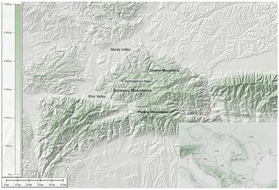
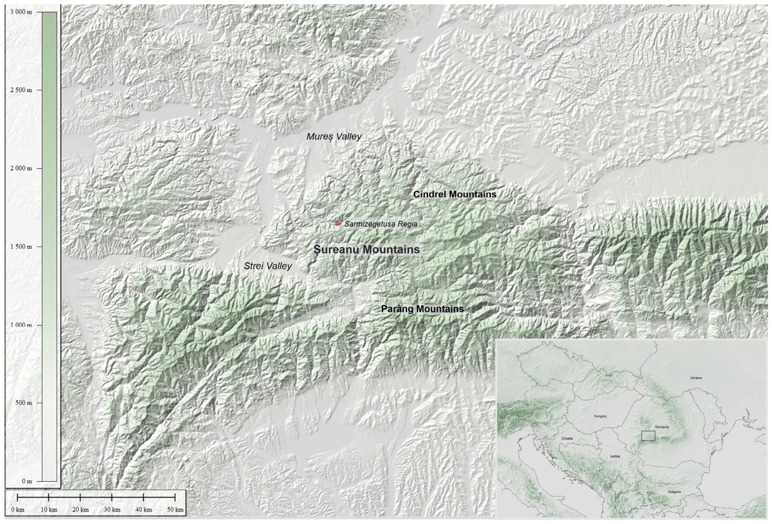
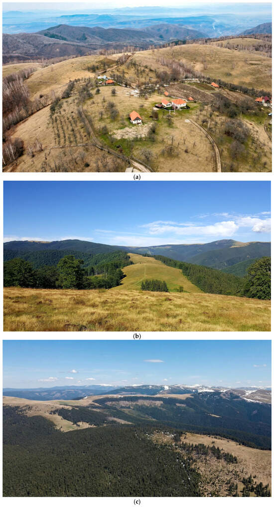
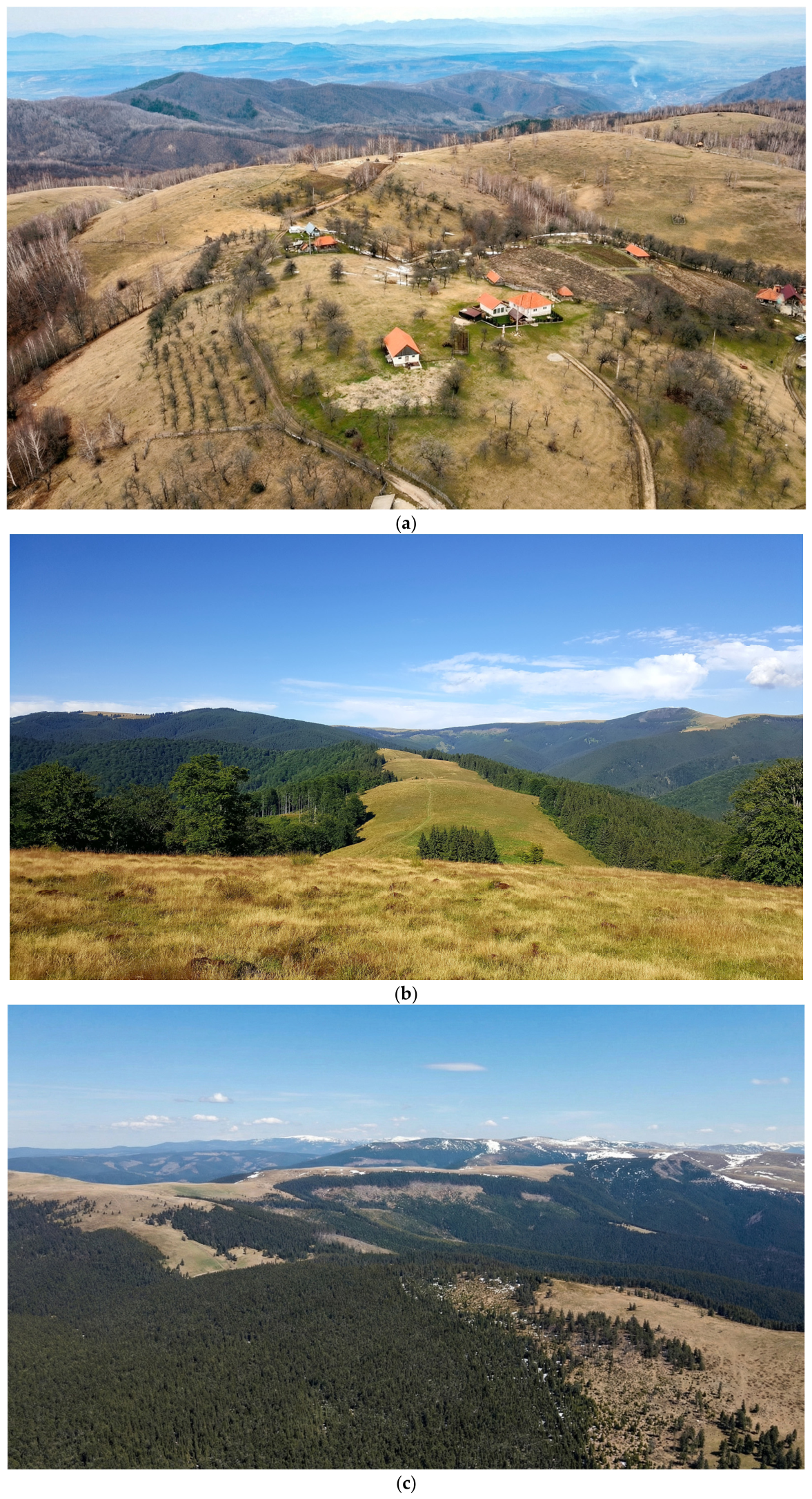
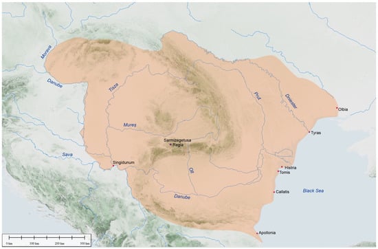
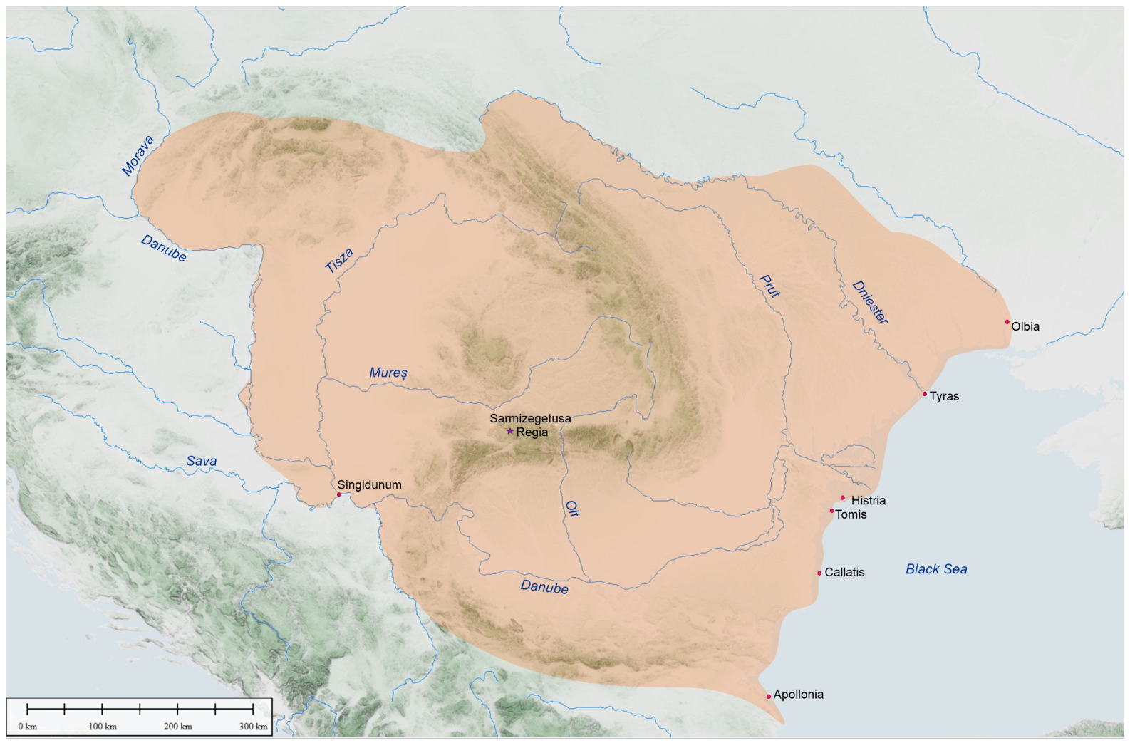
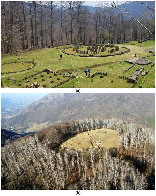
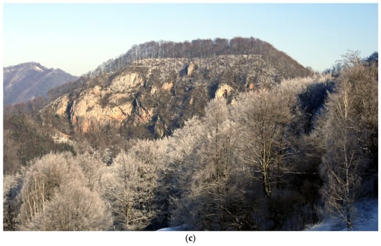
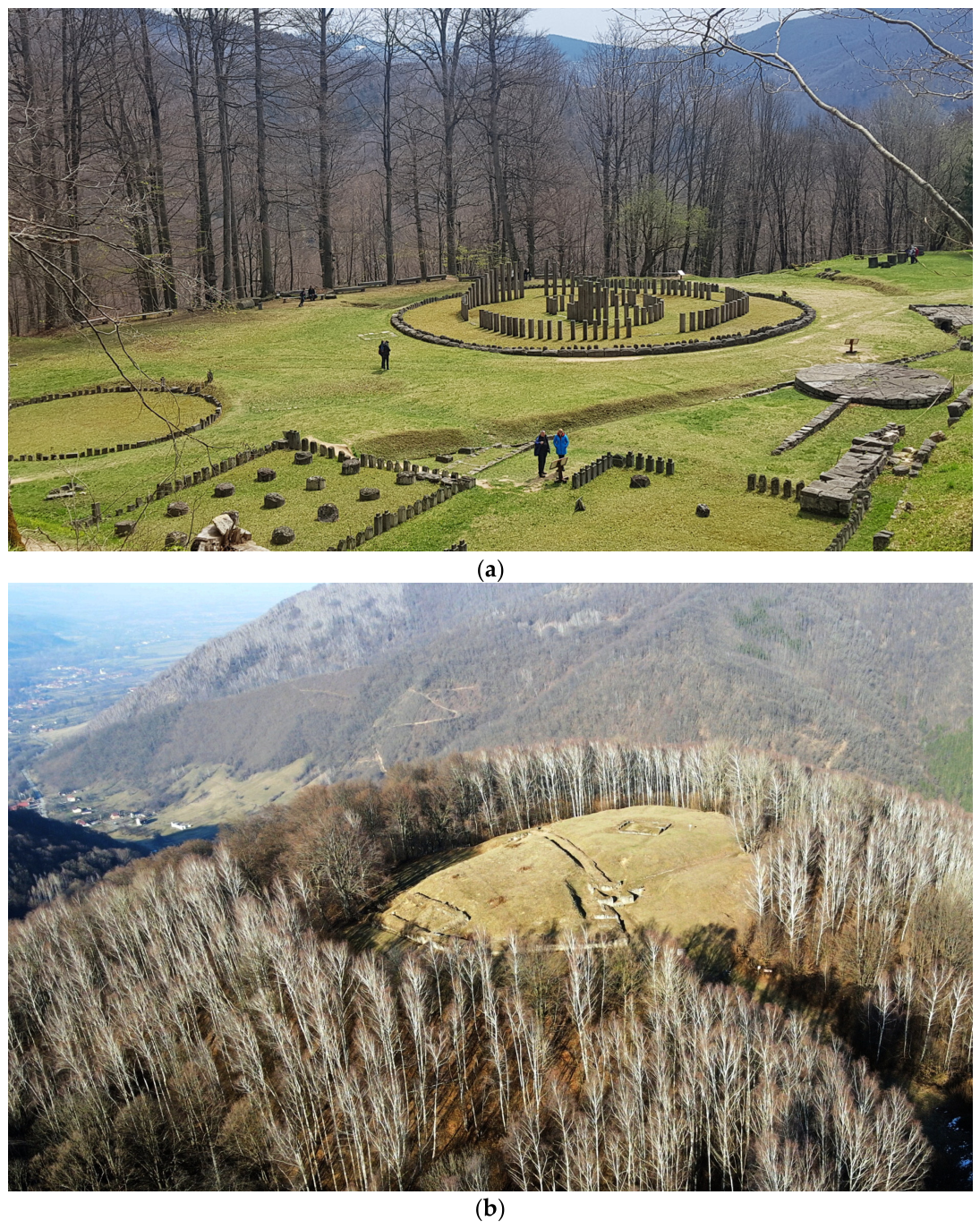
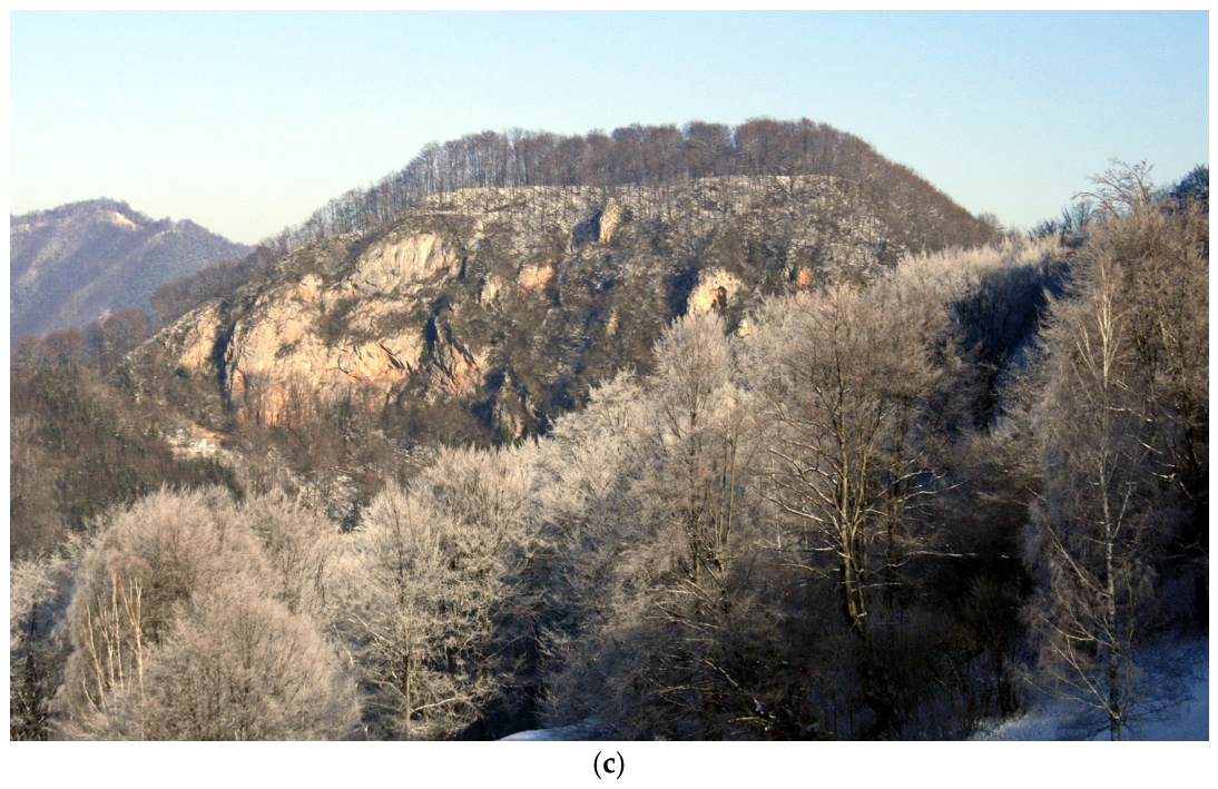
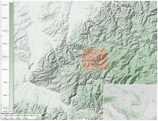
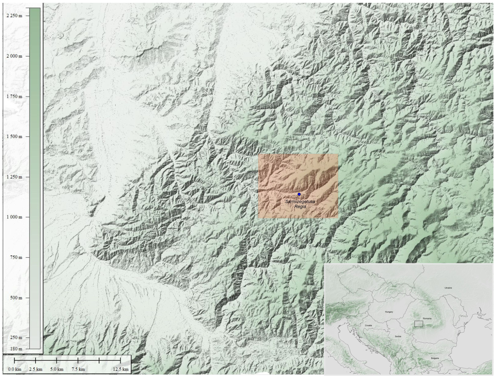
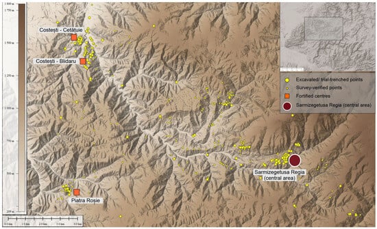
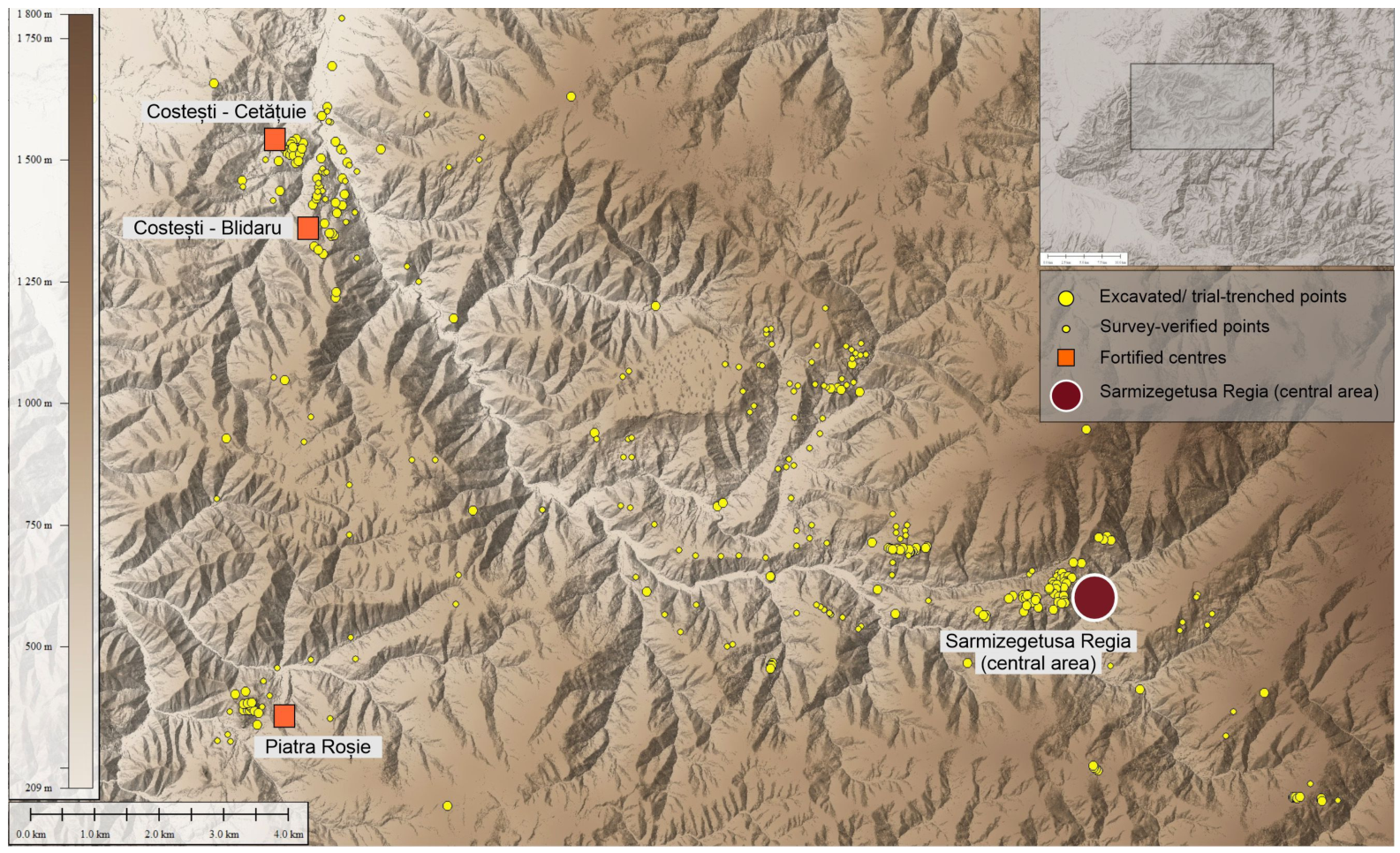
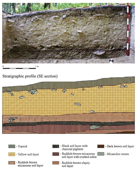
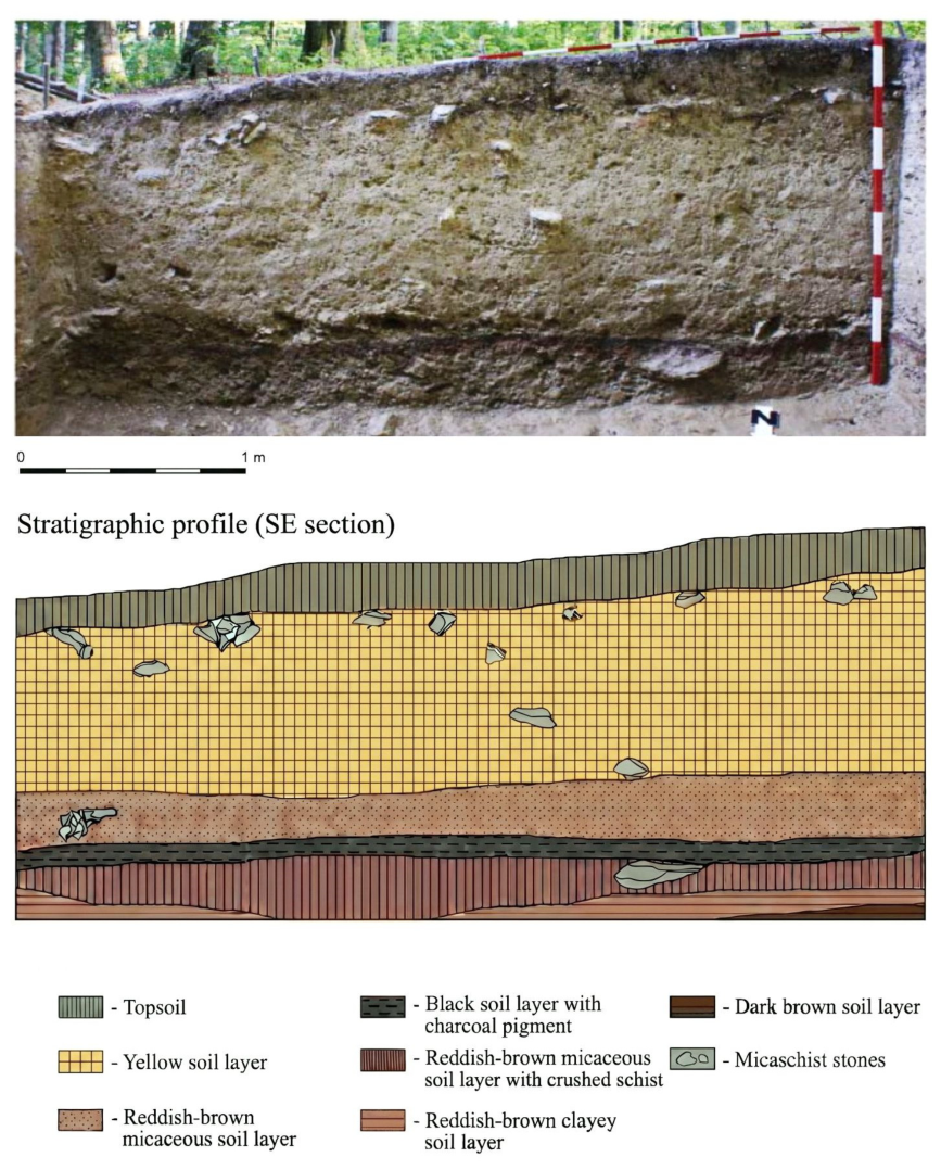
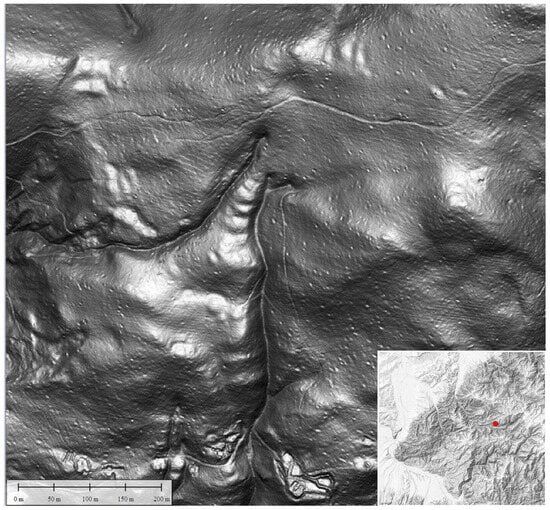
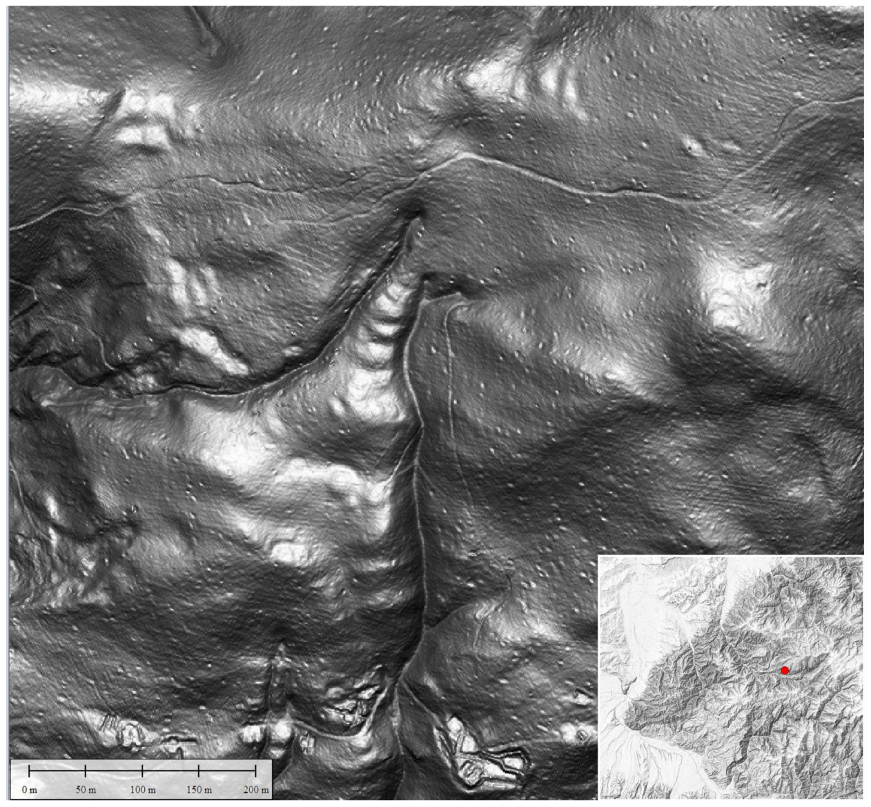
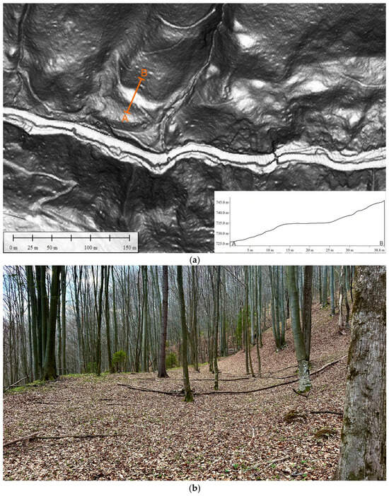
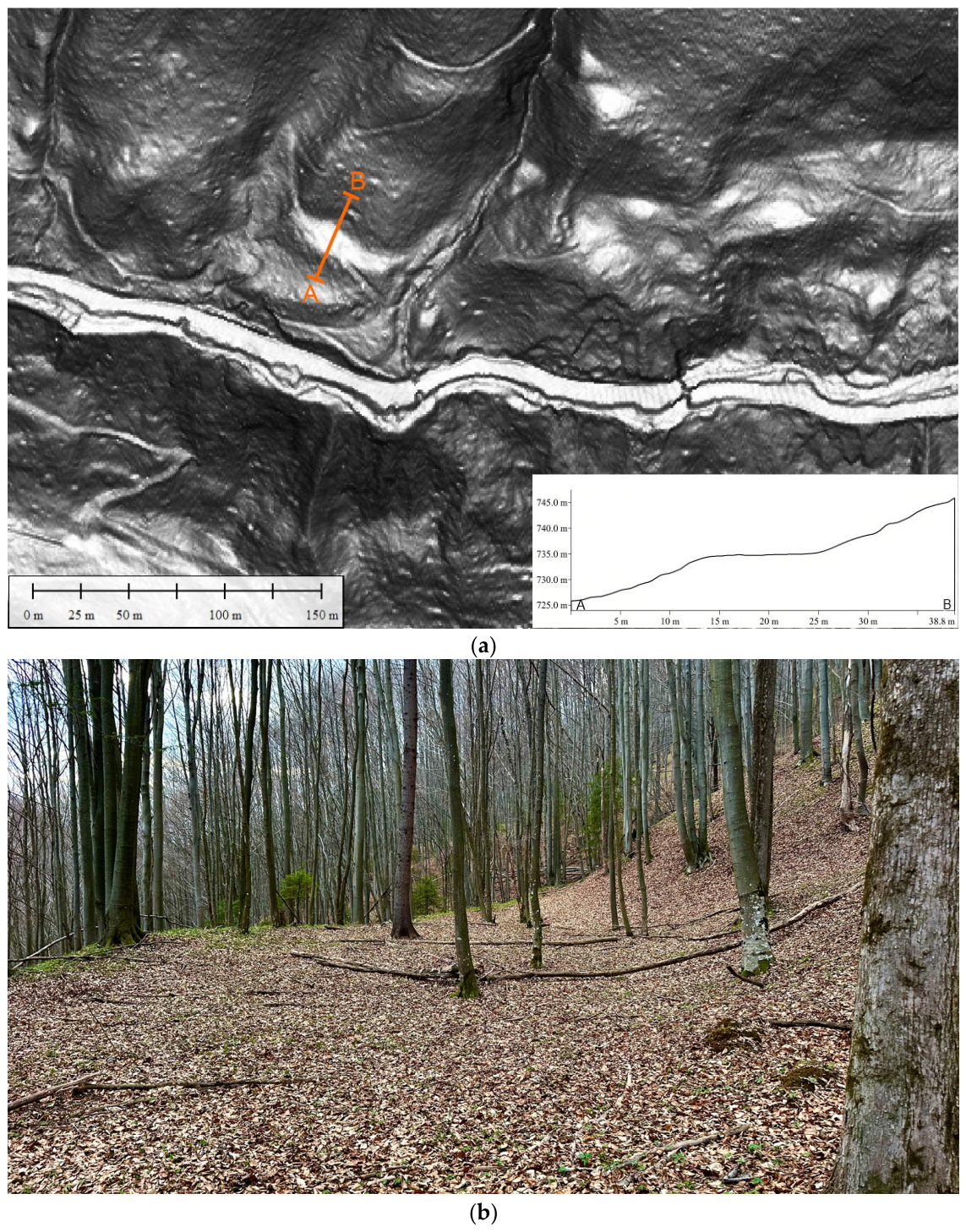
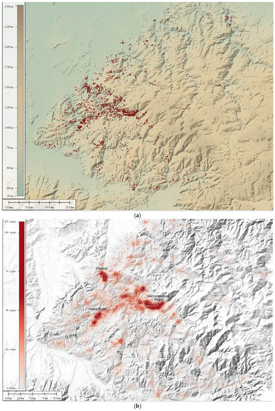
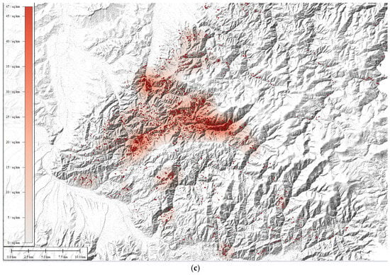
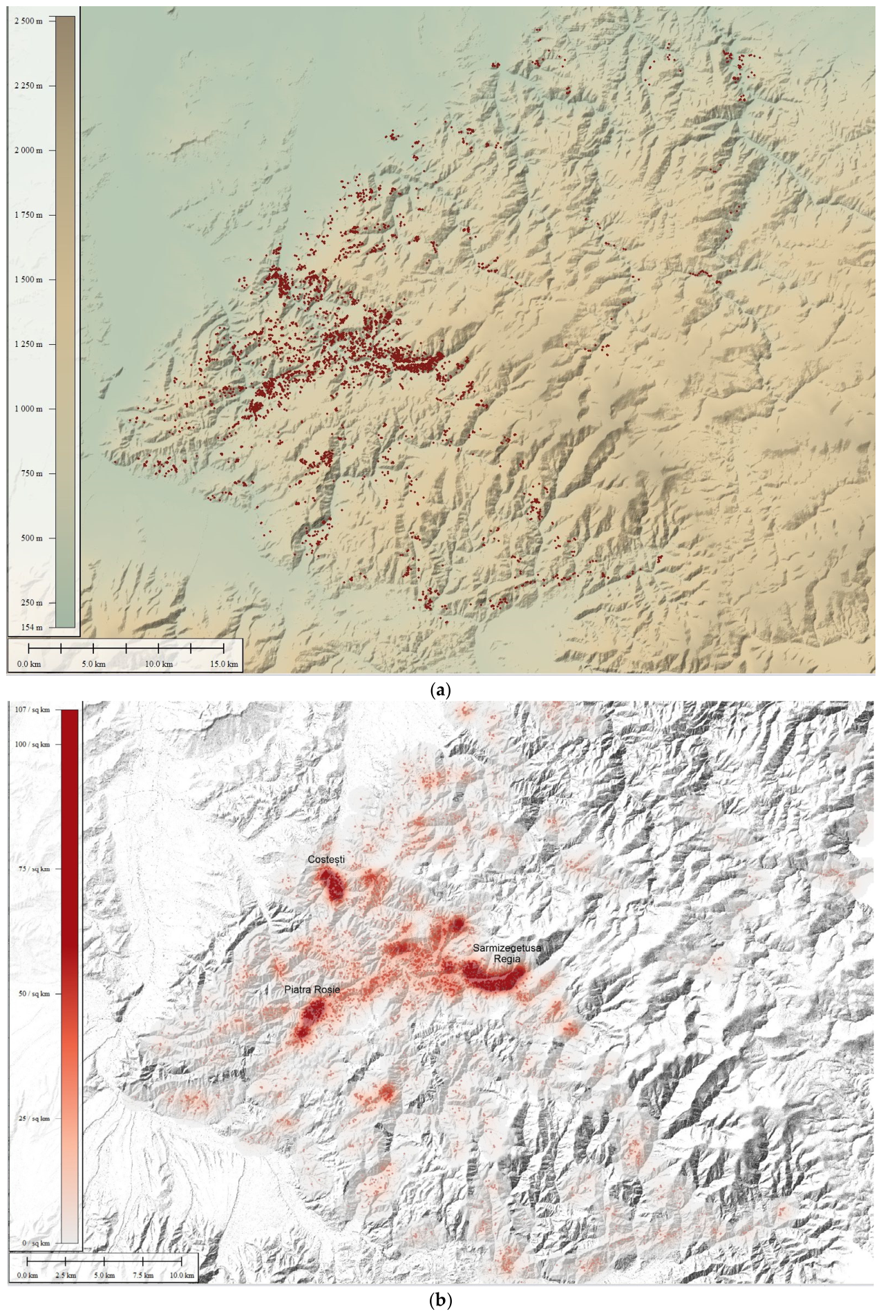
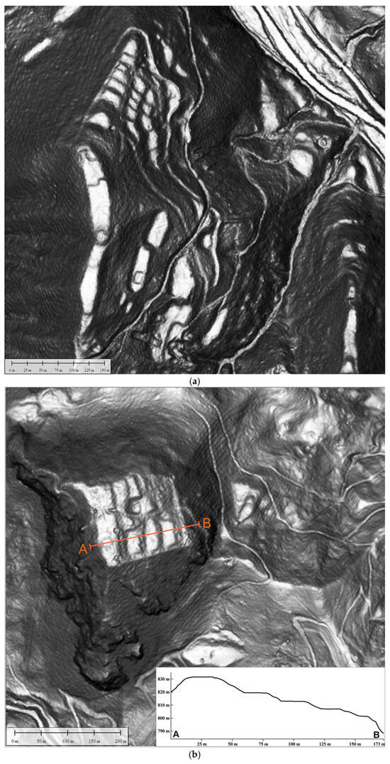
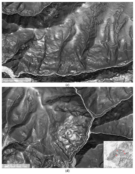
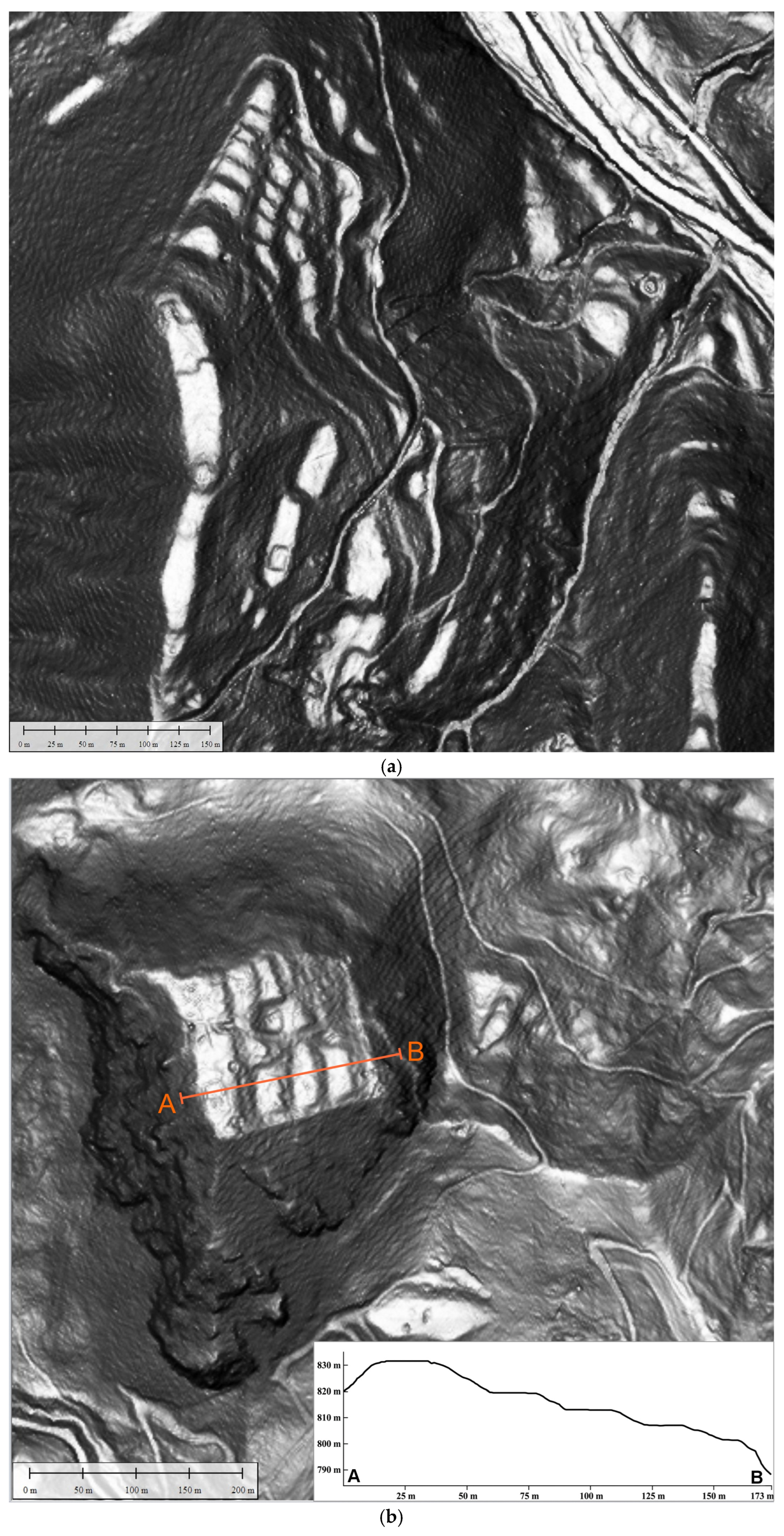
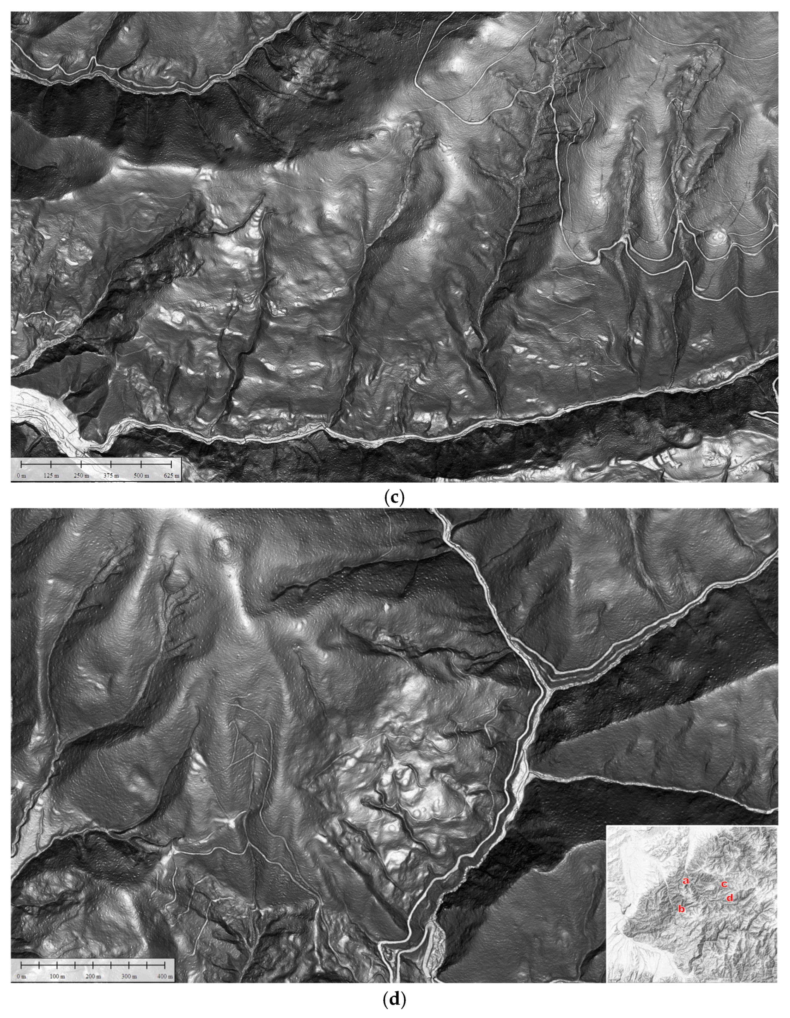
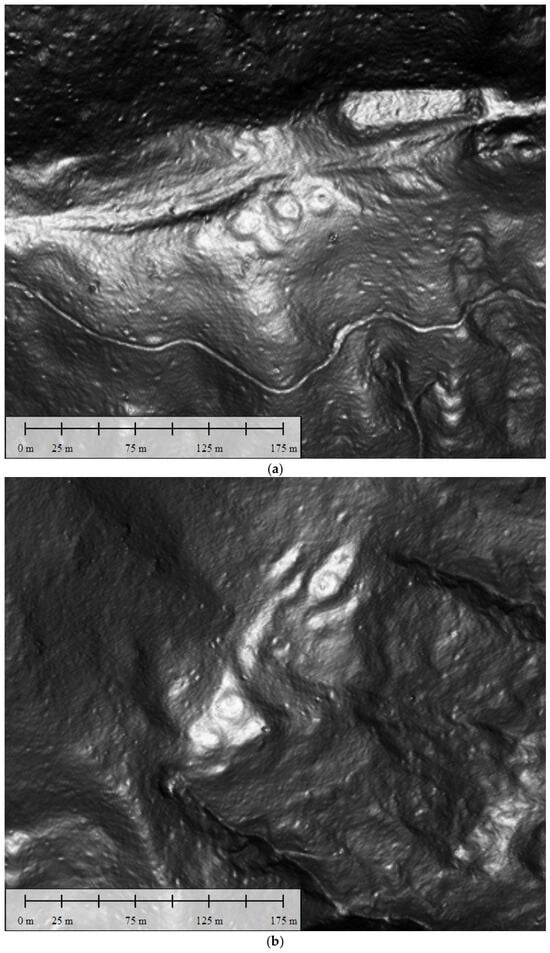
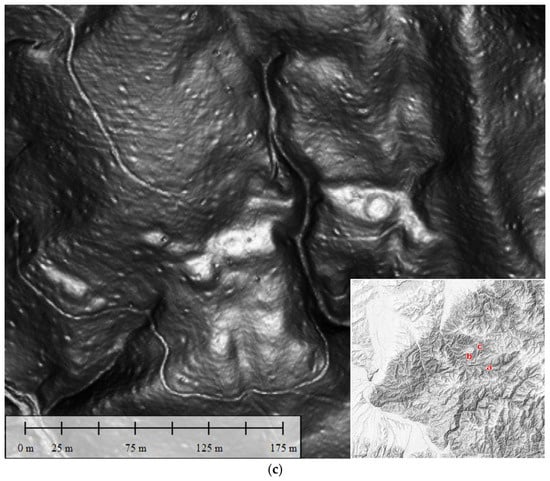
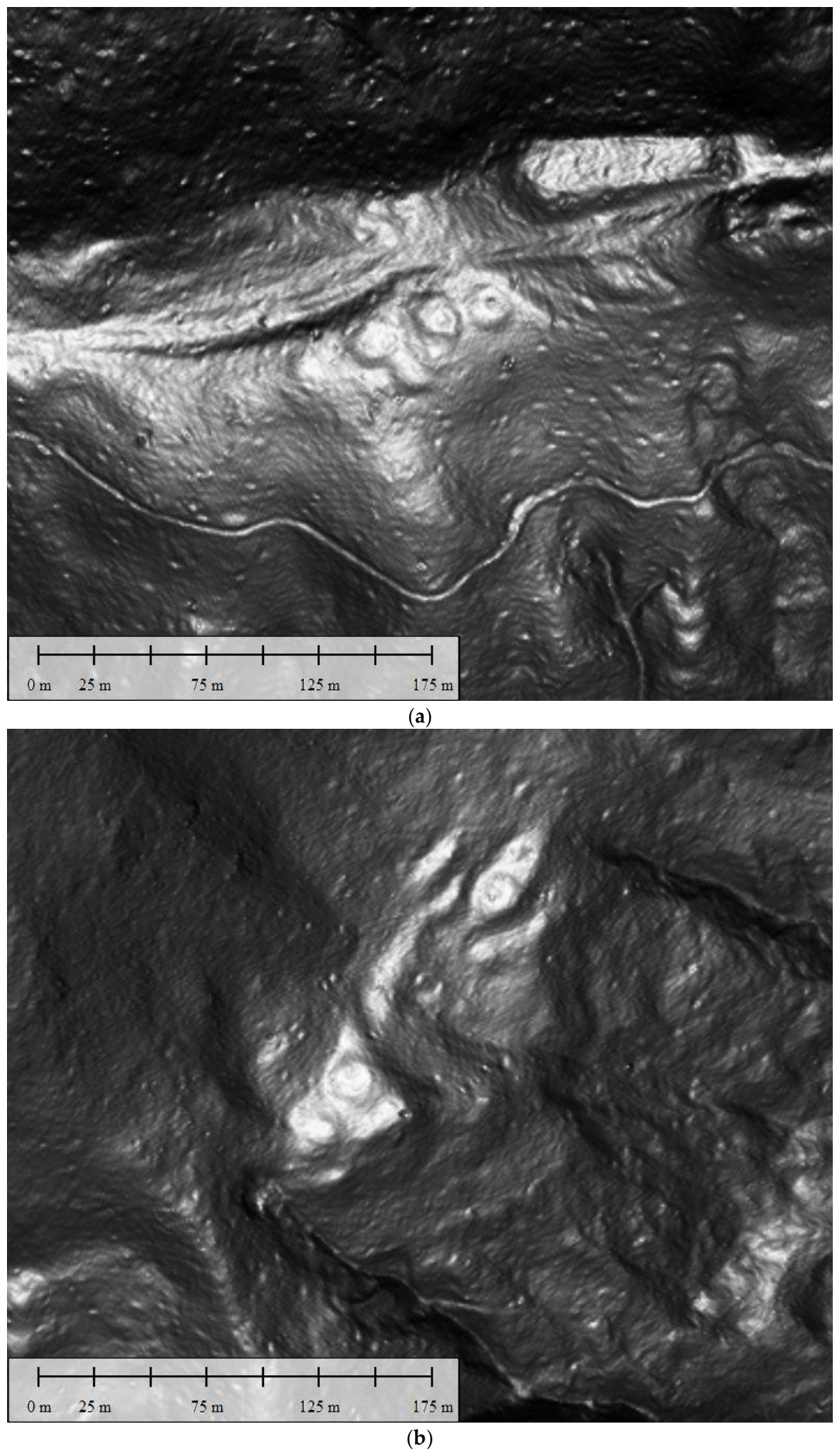
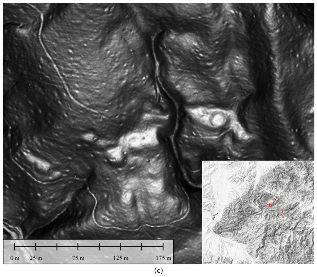
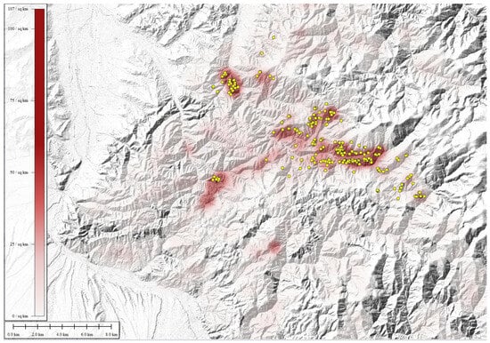
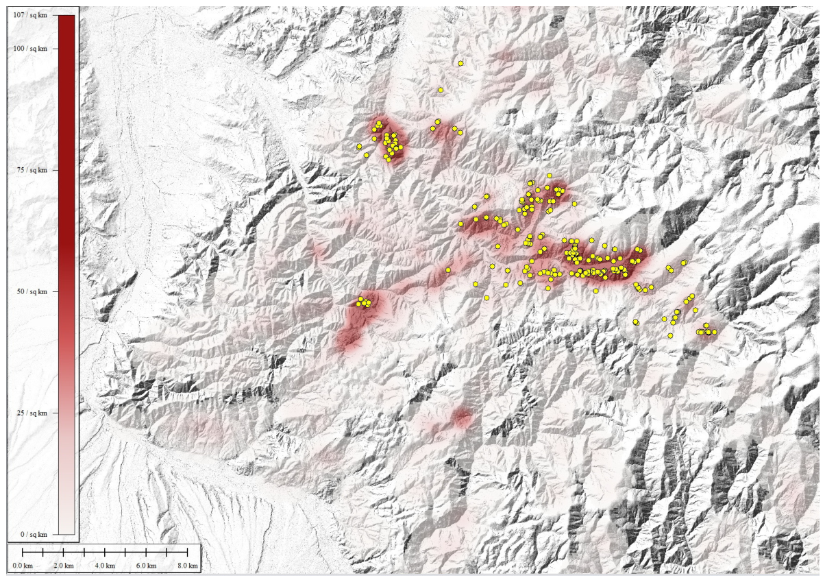
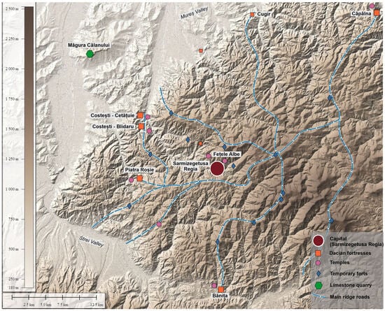
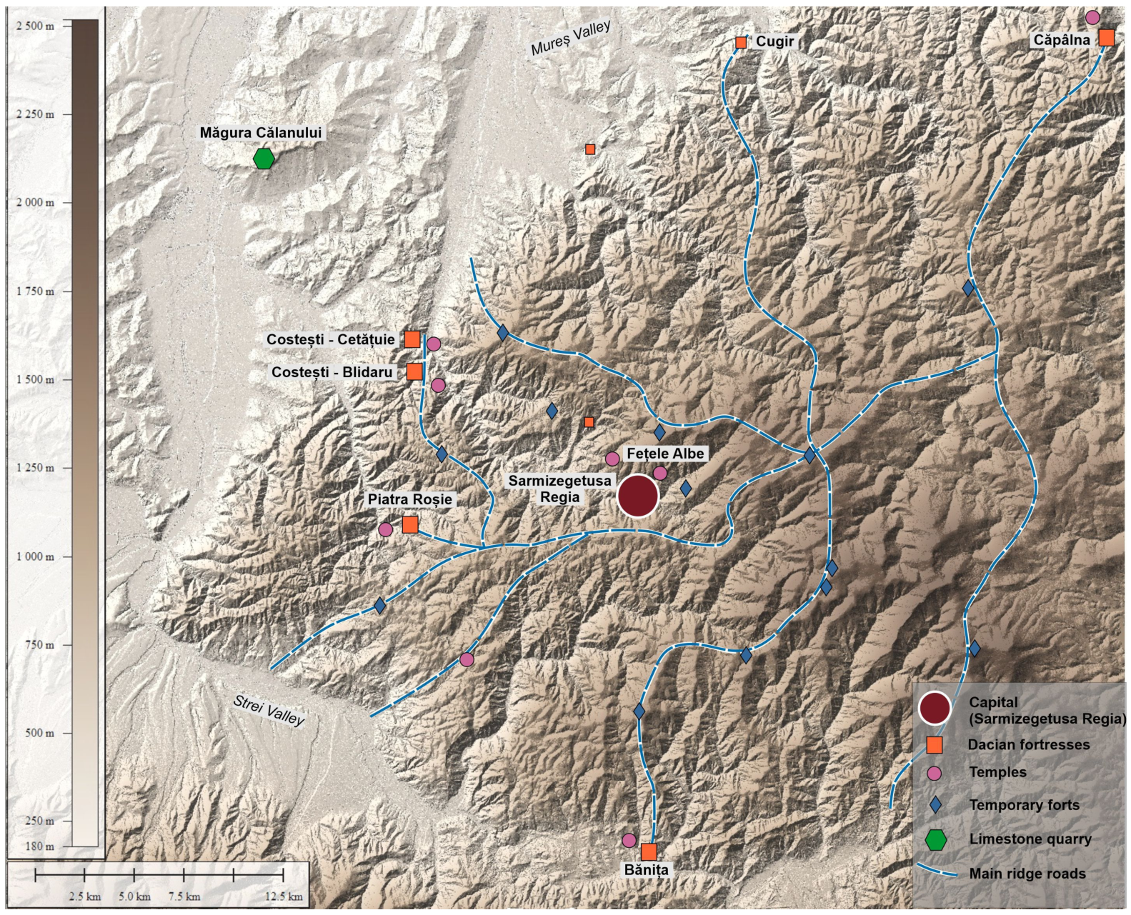
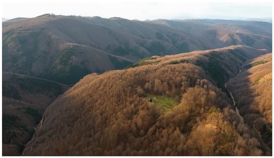
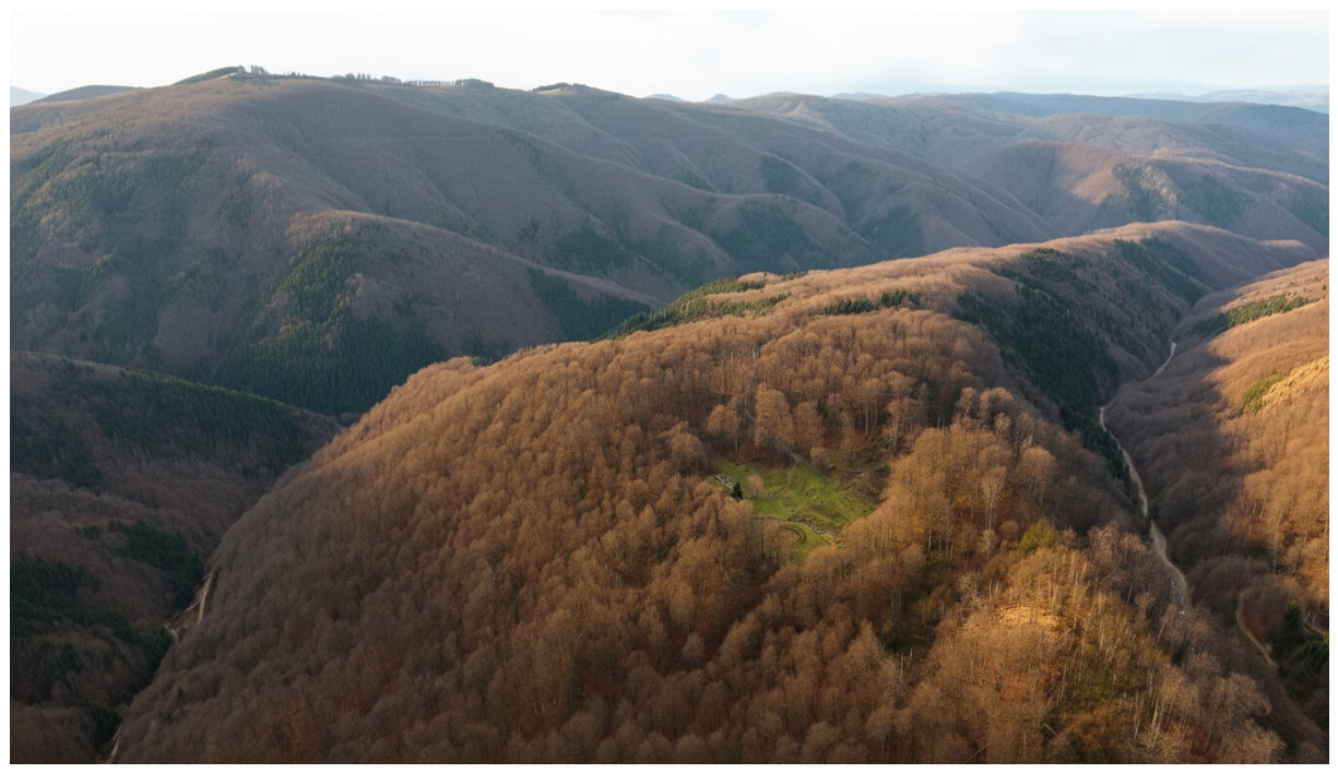
Disclaimer/Publisher’s Note: The statements, opinions and data contained in all publications are solely those of the individual author(s) and contributor(s) and not of MDPI and/or the editor(s). MDPI and/or the editor(s) disclaim responsibility for any injury to people or property resulting from any ideas, methods, instructions or products referred to in the content. |
© 2026 by the author. Licensee MDPI, Basel, Switzerland. This article is an open access article distributed under the terms and conditions of the Creative Commons Attribution (CC BY) license.