


Abstract
Sperlinga is a rock-cut village located in an inner and remote area of Sicily. Despite its cultural value, the village is at risk of abandonment and decay. Can its unique troglodyte architecture be the key for its regeneration and enhancement as a cultural and tourist attraction and how can this precious resource be preserved, within the hoped-for enhancement projects, for the social and economic benefit of future generations? This is the research question of a multidisciplinary research team whose goal was to develop an experimental approach for the implementation of the draft Regulation of urban Decor and Furniture (RDF) by the Municipality, in order to provide elements for a governance process addressed to the preservation of both tangible and intangible values of the village. Based on the classification of the troglodyte settlement as an element included in the class of Underground Built Heritage (UBH) and on results from bibliographic/archival research and onsite inspections, the characterizing elements of Sperlinga’s troglodyte architecture, traditional finishings and some connected intangible values have been classified and listed in a proposal for the integration and update of the draft RDF.
1. Introduction
Sperlinga is a small village in the province of Enna, in the inner part of Sicily Region, the largest Italian island (Figure 1).
Figure 1.
Sperlinga, the rock-cut village in Sicily (by R.V.).
It is located between the Nebrodi Mountains and Val Demone in a very significant area from a geomorphologic point of view.
Today, the village is affected by all the typical demographic, social and economic issues of many inland historical urban settlements [1,2,3]. Firstly, there is a progressive significant demographic decline. In an area of 59.14 km2, according to the Istituto Nazionale di Statistica (ISTAT) data as of 1 January 2026—final data will be released in December alongside the results of the Permanent Population Census—there are 639 residents, with a density of 11 inhabitants/km2. Based on those data, Sperlinga is the smallest Municipality in the Free Municipal Consortium of Enna in terms of resident population [4]. In recent years, the population decline has been progressive: about 697 in 2021 and 789 in 2016, appearing even more evident when compared with the population in 1951, when Sperlinga had 1552 inhabitants, that is 58.8% more than in 2026 [5,6,7].
The aging index is one of the clearest indicators of this decline: based on ISTAT data, in Sperlinga, while there is a roughly constant birth rate—moving from 1.3% in 2016 to 1.5% in 2025—the mortality rate rose from 12.6% in 2016 to 18.1% in 2024 (data for 2025 and 2026 are not available), with a natural balance of −11 in 2024.
This means that there are 488.6 people over the age of 65 for every 100 under the age of 14—well above the national average—with an active population replacement index of 186.2 (indicating a workforce that is aging) and a structural dependency ratio of 65.9 dependents per 100 workers [8,9].
Nor has migration put a substantial brake on depopulation: it was estimated that between 2016 and 2024, internal migration increased, rising from five to 12 individuals, whereas foreign migration plummeted during the same period, falling from five to one recorded individual. Consequently, a net migration balance with foreign countries of −13 and an overall net migration balance of −12 individuals were estimated. Considering this situation, demographic projections for 2050 estimate a population of around 409 for Sperlinga, representing a forecasted decline of 36% from current levels [7]. Furthermore, the economy is largely based on low-level agricultural and pastoral production, and on very few third sector activities: there are no banks; the nearest one is in Nicosia (9 km away) or in Gangi (16.5 km away), while others are located within a radius of approximately 25 km [10]. There are mainly shops selling necessities, only one restaurant and one bar, and no accommodation facilities; the nearest are in Nicosia [11]. Despite the small number of inhabitants aged 0–18, educational facilities are available, ranging from preschool and primary to secondary school, but for specialized training, one must travel to the nearby Municipality of Nicosia [12].
The village is also quite isolated: it can be reached from Enna (ca 44 km away) and the main Sicilian routes via the SS117 or some local roads, primarily by private transport. In fact, the village is served by a single interurban bus line that connects Sperlinga to Enna in an hour and a half, where the nearest train station is located, with connections to Catania Airport—the closest one—which is about 100 km away.
In this context, the mirage of tourism has been identified as a possibility of economic redemption, which, however, is not without risks.
The hoped-for touristic development is supported by the unique architectural character of the village. In fact, Sperlinga is not a usual village, turning out as architecture by subtraction. It originates from an urban development along a rocky slope, overlooked by a Medieval castle, by adopting the so-called “negative building culture”, an approach that involves creating living spaces and service areas by removing and excavating rather than adding material. This is a very ancient and common adaptation solution in the central and southern Italy landscape (Figure 2a), which places Sperlinga within the broader context of those so-called troglodyte [13] or rock-cut [14,15] villages that can be found in Iran [16,17,18], Tunisia [19] (Figure 2b), Turkey [20] (Figure 2c) and China [21] (Figure 2d) and in others around the world.
Figure 2.
Troglodyte villages in the world: Matera’s Sassi in Italy (a), Techine village in Tunisia (b), Göreme in Turkey (c) (by R.V.) and Lijiashan village in China (d) (by L.G.).
However, being a troglodyte village implies both benefits and risks. Whilst Sperlinga is indeed part of a very small group of settlements characterized by a distinctive architectural style, it is also true that this peculiarity raises some very serious governance issues.
In fact, this type of settlement is affected by conservation risks linked to both natural (i.e., collapses linked to earthquakes or hydrogeological erosion) and anthropogenic phenomena: particularly in peripheral areas, the abandonment and the lack of maintenance and monitoring of these environments accelerate the degradation of external built structures and make them welcoming shelters for wild animals or improvised landfills (Figure 3). Urban pressure also has its impacts: there are reports of illegal excavations of deep cavities by private owners or the closure of access to unused ones. While the former jeopardizes the stability of the rocky slope, in both cases, the Municipality is prevented from adequately monitoring the risk of collapse.
Figure 3.
Cave dwellings in the center of the village, in 2021. The rocky ridge collapsed in 2025 due to water erosion, taking with it the remains of the underground chambers (a); the construction of roads and architectural additions have led to significant changes to the ancient layout of the hypogea, and in some cases, even their destruction (b) (by L.G.).
There are also cases of internal and external distortion—i.e., elevation and integration into modern structures—to adapt cave dwellings to the needs of modernity often by using materials incompatible with traditional ones, which in addition to distorting the internal microclimatic performance, clash with the historical landscape context. Furthermore, the prospect of tourism-oriented development poses new challenges that should not be underestimated. In fact, comparisons with more famous contexts highlight how vulnerable this heritage is, in terms of both its tangible and intangible value preservation. Although Matera’s Sassi are inscribed on the UNESCO World Heritage List [22], the Tunisian troglodytic settlements are on the UNESCO Tentative List [23] and many Chinese yaodong settlements are included in protected areas at national level or fall within the boundaries of some UNESCO site [24,25,26], recognition as a successful tourist destination has led to a significant alteration in the vernacular architecture to meet the needs of visitors.
This is explained by the process through which most of these sites have gone through. Before their cultural and tourism potential was recognized, these settings carried a negative stigma linked to harsh, almost primitive living conditions, also causing gradual abandonment.
For example, in the Italian case study of Matera, rock-cut dwellings were interpreted as tangible expressions of the social and economic degradation of the rural population in southern Italy.
The situation became popular after the publication of the famous book by Carlo Levi, “Cristo si è fermato a Eboli” [27], in 1946. The nationwide outcry sparked by the article led to the adoption of a plan for the complete clearance of the cave dwellings and the construction of modern homes in the area surrounding the historic center (Italian Laws n. 619 in 1952 and n. 126 in 1967).
However, from that point on, the term troglodyte has been used in Italian in a figurative sense to refer to an uncultured person who lacks good manners and pays little attention to personal hygiene or the cleanliness of their home.
And it is precisely in Matera—Italy’s renowned and iconic rock-cut settlement [28]—that the transition from an abandoned historic center to a tourist destination has highlighted the critical issues underlying this study.
In Matera, in fact—European Capital of Culture in 2019 [29]—attention has been drawn to the excessive pressure placed on the troglodytic elements, with every excavated space—cisterns included—being transformed into tourist accommodation [30].
Furthermore, in that case, the artificial recreation of excavated spaces was also documented: an initiative designed to meet the growing demand from tourists interested in a troglodytic experience.
In Tunisia, the village of Sidi Driss, located about 40 km from the oasis of Gabès, among the hills of Matmata, became famous as a filming location for the movie Star Wars.
The film sets have even become permanent features, following the transformation of the village into a themed accommodation facility, the Hotel Sidi Driss (Figure 4a); consequently, the tourism offering focuses almost exclusively on this cinematic setting, while neglecting the experience of the troglodytic architecture, an aspect that remains undervalued and entirely overlooked.
Figure 4.
Interiors of the Hotel Sidi Driss (a), fake troglodyte architecture in the Matmata district, in Tunisia (b) (by R.V).
As in the case of Matera, there is evidence of other simulated troglodytic architecture, recreated within various types of accommodation (Figure 4b).
The case of Chinese yaodongs is very difficult to generalize due to the huge number of villages and the multiplicity of factors that influence the choices of recovery and reconversion of sites, with a great variety of levels of protection, local, national, and UNESCO, to which the sites are subject. However, a long-term study conducted by the authors has highlighted that, commonly, tourist-oriented development has led to different levels of reconversion: from individual cave dwellings and/or adjacent service spaces into shops, information centers, or exhibitions, to the transformation of entire settlements into scattered hotels, and more rarely, into museum villages, a sort of theme park where visitors can experience the folk lifestyle. Unfortunately, destruction and re-building are other actions adopted under tourist pressure. These practices are widespread in variable proportions in almost all cases and are considered part of modernization and urban development. Rarely, the materials and techniques used are compatible with traditional ones and with the geo-climatic characteristics of the places. Nonetheless, “developmental destruction and constructional destruction” [31] seem to have a more significant impact on vital centers, if they arise near the famous tourist attractions, where vernacular structures are sacrificed to allocate parking or tourist facilities [26,32].
The Sperlinga case differs from those mentioned. On the one hand, although it is at risk of depopulation, the village remains inhabited, continues to be an autonomous Municipality and maintains some essential local services. On the other hand, despite its unique character, Sperlinga is not included in any of the surrounding protected areas: Madonie UNESCO Global Geopark [33], the Regional Nebrodi Regional Park [34] and the National Etna Volcano Park [35]. Nonetheless, the preservation of tangible and intangible elements that characterize the village and its historic urban landscape is mandated by the regulations of a network to which the village belongs. This network is the Association of “The Most Beautiful Villages in Italy” [36], which requires its members to meet a series of criteria, essential for admission. Except for these guidelines, all the elements are in place for uncontrolled tourism development. Over the last 10 years, various attempts have been made by the Municipality in two main directions. On the one hand, to celebrate local history and intangible heritage with folk events and festivals to promote and strengthen the local identity. On the other hand, to trigger tourism development processes on different territorial scales [37]. However, the efforts made have only had a limited effect on seasonal proximity tourism, without generating development capable of reversing the ongoing economic decline. Nonetheless, these efforts have created a series of unexpected consequences. This is the case of the birth of hit-and-run tourism from the major Sicilian centers, such as Palermo and Catania [38]; or even the recent international identification of Sperlinga as a fairy tale wedding venue [39], further putting at risk a system that is still fragile and unprepared to welcome and manage tourist flows of a certain relevance.
Considering this, since 2024, Sperlinga has been a member of the Union of Municipalities of the Inner Troina Area, comprising 14 municipalities, led by the city of Troina, in the province of Enna. This association aims to engage with the regional government to develop a joint territorial development strategy for the 2021–2027 period that considers local characteristics, needs, and identities [40]. Tourism development is a key objective of this strategy, considering that the role of cultural heritage and related sustainable tourism is widely recognized for the development of inner areas, often difficult to access, but characterized by extraordinary natural and man-made landscapes [41].
The rock-cut village of Sperlinga presents several management challenges. The most critical issues concerned are determining the intended use of excavated or partially excavated spaces, monitoring structural collapses and hydrogeological risks, and preserving the original architecture.
As regards the first point, all cavities—regardless of their specific category—can be classified, for the purpose of their intended use, either as Class A11 (which includes dwellings typical of the local context) or as Class C (which encompasses appurtenances or premises that lack the requirements for habitability but may be used for commercial purposes or to serve primary residences). This follows the classification system adopted by the Italian Revenue Agency to assist municipalities in the categorization of real estate properties [42].
Residential properties are subject to the procedure for the certified notice of habitability (SCA), as governed by Article 24 of the 380/2001 Presidential Decree known as Testo Unico Edilizia (Italian Consolidated Building Act, TUE/2001), and Legislative Decree 222/2016 (LD/2016). The SCA certifies compliance with the requirements of safety and structural integrity, hygienic and sanitary standards, health and energy efficiency.
As regards risk monitoring, although the responsibility for ensuring that properties meet the structural requirements necessary for classification in category A11 lies with their legal owners, the situation differs between private and public spaces. Regarding private properties, current Italian regulations—at the time of registration with the Land Registry or when requesting a change in the intended use (for example, from category C to A11)—require the owner of a property that is wholly or partially excavated to have a building dossier prepared and signed, at their own expense, by a qualified professional (such as an engineer or architect) registered with the relevant professional body; this dossier must, among other parameters, take into account the structural integrity of the building. The situation is different, however, when it comes to public properties. For example, in Sperlinga, the local council has already taken steps to secure certain areas, concentrated mainly around the castle cliff.
Furthermore, with reference to the Sperlinga case study, in 2023, the Department of Cultural Heritage from the Sicily Region (D.D.S. n. 5554/2023) approved a plan for the prevention of collapse risks around the castle financed by the Cohesion and Development Plan (PSC) fund. In 2023, the Italian Fund for Mountain Development (FOSMIT) financed several plans to prevent the risk of hydrogeological instability in the historical area of the settlement (art. 13 D.A. 367/2024). In 2025, the Department for Local Self-Government and the Civil Service adopted some funds from FOSMIT to finance the prevention and the contrast of the risk of hydrogeological instability in Via Gragnano, Salita Mulino and the entrance to the village.
As regards the third aspect, the Regulation of urban Decor and Furniture (RDF) turns out to be one of the main instruments for safeguarding the integrity of traditional troglodytic architecture.
The RDF is a municipal regulation that has its legal basis within Testo Unico degli Enti Locali (Consolidated Law on Local Authorities, Legislative Decree 267/2000), and all citizens are required to comply with it. Italian municipalities adopt regulations in matters within their competence [43].
Even if the process of the development and approval of the RDF does not require a mandatory participatory approach, citizens and other stakeholders may submit comments on the regulations, as established case by case by the Municipality. For example, in the case of the Municipality of the nearby village of Troina, the local council adopted a participatory approach by approving some amendments to the regulations for the protection and decorum of the historic center, which are outputs of that process (local council resolution n. 20, 25 March 2019). In addition, local stakeholders might also be involved in some collaboration agreements for the regeneration and management of common assets after the final approval of the RDF.
In detail, the RDF is a local regulation aimed at safeguarding the aesthetics, hygiene and livability of public spaces in Italian municipalities. It sets out restrictions, rules of conduct and aesthetic standards, for residents and businesses, to preserve the historical and architectural heritage and ensure harmonious coexistence in the public realm. Municipal regulations must comply with higher-level legislation, such as the Code of Cultural and Landscape Heritage (Legislative Decree 42/2004). Municipal regulations concerning urban decor and furniture are usually drawn up by the municipal Technical Area and approved by the City Council.
While these three aspects—classification of intended use, monitoring, and protection—may share some common ground, they are regulated entirely independently of one another; nevertheless, once the RDF is approved, all property owners—whether private individuals, housing associations, or public entities—will be required to comply with the regulations set forth therein.
The imposed restrictions shall also apply in the case of public and private funding—sourced from the Region, ministerial funds, EU funds, etc.—obtained for any purpose and intended for extraordinary maintenance of protected assets, even where such interventions are related to the monitoring and mitigation of risks.
The RDF does not regulate all the phases of regeneration and maintenance projects within historical centers but rather sets out some principles governing interventions, to which not only all those authorized to carry out work on buildings must adhere but subsequent municipal regulations must as well. The RDF also provides for the establishment of sanctions for any violations; however, this document serves solely as a framework for drafting regulations, a matter that falls under the exclusive jurisdiction of the local authority.
In detail, in Italy, planning permission for extraordinary maintenance works (in accordance with Article 3, paragraph 1, point (b) of Presidential Decree 380/2001) depends on the nature and impact of the works on the structural elements. No planning permission is required (free build) only if the works fall within the scope of so-called minor works in the glossary or if they constitute routine maintenance. CILA (Certified Notification of Commencement of Works) applies to extraordinary maintenance works not concerning the structure of the building and not altering the building volume and intended use. SCIA is required for major extraordinary maintenance works affecting the building’s structure and restoration concerning structural parts. If the works alter the total volume or the intended use of the property, this falls outside the scope of extraordinary maintenance and is classified as major building renovation or as a case requiring a Building License (BL). The granting of a building permit is subject to any existing landscape, historical or seismic restrictions imposed by national or regional regulations. Where a landscape restriction applies, the granting of planning permission is conditional upon obtaining landscape authorization (Article 146 of Legislative Decree 42/2004), a separate and prior decision issued by the competent authority (the Region or delegated Municipality) with the binding opinion of the Superintendency. The RDF acts as a municipal law aimed at preserving the town’s aesthetic and traditional character; it will be the responsibility of the municipal technical officer to verify that the project meets the conservation requirements set out in the RDF before granting the building permit to the property owner. Breaches of the urban decorum regulations (RDF) result solely in administrative penalties or the obligation to bring the building into compliance, whereas carrying out works in breach of the regulations or without authorization in an area subject to a genuine landscape restriction constitutes a criminal offence (Article 181 of Legislative Decree 42/2004).
Despite the decision by the competent authorities to equip Sperlinga with an RDF, the internal technical administrative department reportedly encountered difficulties in developing it independently.
Indeed, the administrative office—tasked with handling all key municipal functions, from waste management to budget administration—has a staff of 13 employees, many of whom fill multiple roles. As regards the technical and town planning department, there are only three staff members, headed by a surveyor; the internal staff does not include either an architect or an urban planner/landscape architect. Based on this evidence, a local consultancy firm was awarded the direct contract.
On December 2021, the Municipality commissioned the architect Leonardo Principato Trosso, as an external consultant, to write the new RDF (Regolamento comunale di decoro e arredo urbano di Sperlinga, CIG: Z7034A2B11), with the aim of preserving the village in case of any future urban transformations. The technical document, which includes images and drawings, addresses urban elements and features—pertaining to buildings and public spaces—that define the character of the urban landscape in zones A1 and A2 (“continuous built-up areas”), which correspond to urban areas of environmental and artistic significance. The proposed RDF consists of sixteen articles, related to public areas and decor of public spaces, focusing on elements of urban furniture, and setting guidelines for windows and fastenings, main doors, color of façades, signs, flowerpots, lighting, and technical elements. It also deals with occupation of public areas, defacing of property, construction sites, etc. (Studio di Architettura & Urbanistica Arch. Ing. Leonardo Principato Trosso, 2023).
Nevertheless, the Municipality’s internal technical administrative department realized that the draft RDF document might be more tailored to the specific characteristics of the area concerned and the peculiarities of the rock-cut village: the castle built on the rocky hill, various typologies of artificial cavities and ancient caves. With reference to the RDF, Sperlinga being a troglodyte village, the preservation of urban quality—which is the goal of this specific local regulation—requires a differentiation of the area at stake, considering the castle area, the fortified village and the artificial cavities as well. In addition, special attention should be given to the significant historic and cultural features of the village, with greater focus on external façades and building coverings, signage and posting for communication, and other traditional elements [44].
Following discussions between the municipal technical administrative department and the current Councilor for Tourism and Urban Aesthetics [45], it became clear that the new regulatory framework should take into account the troglodytic architecture of the village, encompassing both the tangible elements of the historic built environment and the intangible elements that have characterized the settlement throughout its history.
This approach involved the architect responsible for drafting the RDF being supported by professionals in many fields, in a rare Italian case. The advice of an archaeologist was deemed essential, for dating artefacts, analyzing historical changes in their uses and shapes and providing interpretation of rock-cut architectures as local cultural heritage. An urban historian and an architect were brought in to delve into the analysis of the urban settlement and the sustainable development of the village. Finally, the advice of an expert in cultural tourism was also considered to investigate the village’s potential as a tourist destination and evaluation of associated risks. In addition, tools for the classification of traditional urban tangible and intangible values, to be adopted as focus points in the regeneration of historical villages, were required, for the social and economic benefit of local populations.
The Municipality’s goal was to have a conservation plan in place, to prevent risks of unpredictable urban transformations connected to uncontrolled tourism development, as also suggested by the 2030 Agenda for Sustainable Development [46]. In this perspective, the local administration has decided to enlist the collaboration of a group of researchers under an agreement that is already in place. A Memorandum of Understanding (MoU) was signed between the Municipality and the Institute for Studies on the Mediterranean (ISMed) [47] from the CNR (ref. CNR-ISMed 49/2022, 20 January 2022) within the activities of the research line “Underground space for territories knowledge and enhancement” [48] to evaluate solutions for heritage protection to be introduced in the plan. Subsequently, in view of the cultural heritage at stake, the Municipality of Sperlinga decided to implement the MoU already signed with the CNR-ISMed and an additional agreement was signed in accordance with Article 15 of the Law of 7 August 1990, again between CNR-ISMed and the Municipality of Sperlinga (ref. CNR-ISMed 58201/2024, 21 February 2024), specifically focused on the technical/scientific support that the research institute should have provided for the elaboration of a scientific report to support the new RDF for Sperlinga. In fact, Article 1 of the supplementary document to the original MoU states that “having recognised the need to supplement the current townscape and street furniture plan with measures that reflect the distinctive character of the village, so as to enable its sustainable development from a cultural perspective”, the Municipality intended to draw on the expertise of CNR-ISMed to carry out this service.
As part of this agreement, a multidisciplinary research team has been created, with specialists from the CNR ISMed and the CNR Institute of Heritage Sciences [49], who already had experience in studying this area and, in general, the typology of the caved settlements, and an architect/PhD in evaluation methods for cultural heritage.
The team of specialists tasked with incorporating the provisions of the new municipal regulation, the RDF, was responsible for highlighting the village’s distinctive character, drawing on information from municipal records and the findings of previous studies. Where these proved insufficient, they drew on the results of onsite inspections and existing analytical tools.
The research illustrates the experimental approach adopted by the author’s team—composed of an urban historian expert in territorial marketing, an architect focused on cultural heritage, urban and spatial planning and an archaeologist expert on cultural tourism—in the implementation of the previous proposal for Sperlinga’s new RDF. It combines the adoption of existing theoretical tools dedicated to homogeneous elements of cultural heritage with the development of a newly introduced methodological approach based on the elaboration of both first-hand data and results from onsite inspections. The final goal was to provide the Municipality of Sperlinga with tools and provisions to support the classification of typical elements of troglodyte architecture that must be preserved within the new RDF that the Municipality should hopefully approve in the form of a local regulation. Once the new regulations come into force, they will not only provide guidelines for any regeneration projects carried out by the local authority, but—as provided for in the legislation in question—they will also apply to private individuals in relation to their private property. In fact, the main goal of the RDF is safeguarding the village’s vernacular architecture from the actions of all those who, at different levels and both for public and private benefit, might alter it and, at the same time, to rectify any distortions that may have been introduced by actions taken prior to its implementation, overall, if Sperlinga moves towards its hoped-for development as a tourist destination.
2. Materials and Methods
Research activity took place in the period 2021/2025 and included the elaboration of data from bibliographies, results from institutional dialogue and discussions, critical analysis of current and historical municipal cadastral, service and network maps and results from four onsite inspections of case studies by the authors.
With reference to interactions carried out, they were realized during several institutional meetings with elected political representatives at Sperlinga Municipal Council: the mayor, the deputy mayor, relevant councilors and technical bodies—mostly the surveyor in charge of the technical office—and some local historians in charge from the Municipality. This phase was addressed to gathering information on the municipal government’s policy priorities and unpublished data as well. Meetings and discussions with technical staff from Sperlinga Municipal Council were supported by sharing several institutional charts and documents, cadastral maps and projects already funded for the regeneration of the historic center. The council also involved a local historian, who provided his publications on the website, and the council’s in-house library service, which supplied all available documentation relevant to the work in progress. These meetings, held throughout the working group’s inspections, were followed by exchanges of documentation, information and data. These institutional meetings were held in accordance with the MoU signed between the Municipality of Sperlinga and CNR-ISMed, whose article 8 states that “the signers of this MoU (the Municipality of Sperlinga and CNR-ISMed) mutually undertake that the ‘personal data’ information, whether in paper or digital form, provided—including verbally—for pre-contractual activities or otherwise collected as a result of and during the performance of this agreement, shall be processed exclusively for the purposes of the agreement itself”, which includes the drafting of guidelines for the preparation of the RDF.
Results and discussion consisted of the following phases:
- (1)
- Sperlinga’s new RDF: From the critical analysis of the proposal from the local firm to the scientific approach of the CNR team. Limits and opportunities from the MoU between the CNR-ISMed and the Sperlinga Municipality.
- (2)
- Detection of critical issues in terms of monitoring, understanding and promotion:
- The interpretation of the rock-cut Medieval castle with its iconic excavated corridor, the rupestrian church and the subsequent building in connection with the rock-cut village and the reuse of abandoned burials;
- Collapses and abandonment;
- Unknown ownership;
- Seasonal, local and poor tourism.
- (3)
- A plan for the implementation of the current proposal for a new RDF:
- A special focus on the troglodyte habitat;
- The rock-cut village of Sperlinga as an element of a defined class of elements of cultural heritage;
- Classification of types of cavities;
- Classification of types of traditional finishes to be preserved and critical issues identified during inspections;
- Classification of intangible values to be preserved and included in the RDF plan;
- Integrations into the current RDF.
- (4)
- The new RDF as a starting point: Actions to be taken by the local authority to ensure the plan is properly implemented.
- (5)
- Conclusions.
3. Results
3.1. From the Current RDF to the Scientific Approach: Monitoring, Understanding and Promotion
In the initial research step, the troglodytic village was described and its dimensions determined based on land registry records and the literature. As regards the first aspect, the analysis of the current cadastral plan reveals that structures with troglodytic architecture are not shown graphically, nor considered. This is an important difference compared to the previous 1936 map (Figure 5), where cavities were depicted, with their actual size, and adequately differentiated from the buildings above ground by the dotted perimeter. Furthermore, care was taken to distinguish the independent units—likely houses, stables, or warehouses—which are assigned a land registry number, from those pertaining to other elevated structures, of which they represent cellars or storage rooms. The difference between the two documents can be read as a changed value attributed by the community to these excavated environments from the 50s as an effect of the stigma attributed to troglodyte settlements after the abandonment of Matera’s Sassi.
Figure 5.
Cadastral map from 1936. Details of the eastern portion of the settlement included on sheets 14 and 22. The dashed perimeter indicates the individually stacked cavities (a) (@comune di Sperlinga); the red lenses represent those pertaining to elevated architecture (b) (additions by L. G.).
During this phase, the cave dwellings on the eastern slope gradually became depopulated; cavities in the rest of the village bit by bit underwent modifications, whose traces have not been recorded anywhere, giving space, in the western area, to the period of modernization and related urban expansion.
Even the literature, generally compiled by local historians, provides little information about the troglodytic village, mainly focusing on the Medieval castle (from 11th century ca.), renowned as a theatre of the Sicilian Vespers [50,51]. Archaeological research is completely absent even if sporadic remains of rock cavities suggest the function of burials of remote data and are difficult to define. The castle itself was carved into the rock, probably, starting from the deepening of the excavation of a previous settlement, thus obtaining multiple underground spaces (storage, prisons, water deposits, residences, etc.). Sperlinga developed at its base, in close relation to it, with a top-down approach. It is organized in overlapping rows of caves—approximately nine levels in the western portion of the town and five in the eastern portion—along the level curves of the rocky ridge. The village developed along the line of the hill in a west–east direction, with a “spindle” layout and the historical connections are ensured by narrow streets and steps obtained by modeling the rock.
In the upper part, the village still shows a Medieval appearance, with cave dwellings and hypogea dug directly into the rock on which the castle rests (Figure 6).
Figure 6.
In the western portion of the settlement, cave dwellings and hypogea were dug directly into the rock on which the castle rests (by L.G.).
The historic center area winds along narrow, winding alleys, exploiting the geomorphology of the ridge, which, when necessary, is excavated or leveled to create underground spaces and extract material for the elevations. According to the 1936 map, there were approximately 130 stacked cavities, as well as numerous others that are among the appurtenances of elevated structures (Figure 6). Along the eastern slope is the area of the most characteristic and well-documented cave dwellings in iconographic sources, with approximately 58 cavities of various types, some of which were destroyed by the construction of the SS 120.
The urban layout of the village has remained mostly unchanged over the years, as represented in the cadastral map of 1936. Sadly, the lack of information in the new cadastral map determines great difficulty in the definition of new urban planning addressed towards the settlement’s sustainable development. This gap must absolutely be remedied before the definition of the new RDF to allow the most suitable consolidation and recovery practices with respect to the character of the typologies of cave dwellings involved in the intervention.
3.2. The Inspections
Even if the MoU with the CNR-ISMed dates to 2023, the site inspections by the authors began in 2021 and continued until the end of 2025. The following Table 1 summarizes the main phases of the work and the results achieved.
Table 1.
Inspections by the team (R.V.).
The inspections were carried out by adopting the data collection form shown in Figure 7. This form is the result of work by the authors, based on the revision of the registration form for artificial cavities (CA), a form commonly used by the International Union of Speleology (UIS) [52]. This reworking became necessary due to the specific conditions under which the site inspections were carried out, the aim of the inspections, and the unique characteristics of the cavities investigated, as will be detailed below.
Figure 7.
The data collection form used during inspections (English version) (by R.V.).
It should also be noted that the form serves as a guide for future actions—outlined in point 18—which, while falling outside the scope of the RDF’s remit, are nonetheless necessary for the management of the underground structures in question.
Since the objective of the RDF is to regulate the historical and landscape-related aspects of the troglodytic settlement, an information sheet was prepared—even in cases where access was unsafe, obstructed, or not authorized by the owners when known—in order to define the guiding criteria to be incorporated into the regulations; the type of site visit conducted, which was based on an examination of the exterior, has also been noted.
Regarding the traceability of ownership of abandoned properties, interactions with representatives from the Municipality have revealed that the local council is attempting to trace the rightful owners and to incorporate the abandoned properties into the council’s assets.
At the time of the investigation, the prevailing circumstances made any monitoring activity—and even access itself—particularly complex, given that it is not possible to seek authorization from the rightful owners.
However, even a simple inspection from the outside—or a glance through closed gates or unhinged windows—revealed a state of general abandonment, with structural collapses inside. Some areas are still used for storage; those in the lower part of the castle have been converted into exhibition spaces; others house chicken coops and show traces of various artisanal activities.
Results from inspections were also carried out by adopting the criteria and tools illustrated in Section 3.3 and Section 3.4.
3.3. Troglodyte Architecture and the Underground Built Heritage Class
When an urban development is characterized by the excavation of public and private spaces, rather than adding building materials to create volume, the correspondent village can be included in the class of Underground Built Heritage (UBH) [53]. The theoretical approach includes the definition of common characters, the classification of types and functions, and several tools for their static and dynamic analysis. With reference to the first aspect, UBH classifies all excavated artefacts that today are considered significant elements of local cultural heritage and that can be at the core of selected regeneration plans. Based on this inclusion, Sperlinga can be analyzed by adopting all tools provided in the theoretical approach for the analysis of both environmental and social issues, on the basis of subtractive architecture and for the classification of historical functions and reuses as well. The classification of historical functions is based on archaeological evidence; this is why adopting the UBH approach requires the involvement of a multidisciplinary team. Hollows for oil lamps, remains of fireplaces or sleeping areas, feeding troughs, hooks for cradles or for tethering animals, layers of soot, etc., all support the archaeologists’ work at this stage. However, it should be made clear that, particularly in troglodytic villages, certain spaces were used for multiple purposes: the family lived in the same space where animals were kept, typically mules, used as a means of transport, as well as hens and cows.
In Figure 8, Sperlinga is studied by adopting the first tool provided by the UBH methodological approach based on the state of the art of archaeological research. The chart shows how the excavated spaces can be classified into two different groups: the first includes those dwellings that were carved out to manage a given function from the beginning (in blue) and the second that includes dwellings initially excavated to manage a given function and that were then reused to manage another one (in yellow). The Medieval castle (defense), water channels dug to collect rain waters (waters) and tombs (burials and rituals) can be listed in the first group. The second comprises a series of spaces that originally served the castle, but which subsequently gave rise to the creation of an autonomous urban space, created by reusing and reshaping old burial chambers: service areas, shops and whorehouses (economy), food canteens (food) and houses (living space). In gray, the functions that cannot be found in the Sperlinga case study: Sanitary—which refers to sanitary pools and sewers—and Transport, which refers to galleries excavated for historical railways.
Figure 8.
The UBH chart interprets Sperlinga’s troglodyte village: colored functions can be found in the Sperlinga case study: Water, Food, Burial and Rituals, Defence, Economy and Living Space (by R.V.).
The adoption of the UBH approach has supported the interpretation of the results set out in point 5 of the table in Figure 7.
Figure 9 represents the adoption of the second type of UBH tool for Sperlinga’s case study. It focuses on the relationship between living spaces built by adopting subtractive architecture and the characteristics of the local area. The chart highlights how troglodytic villages can meet various climatic, geographical and social needs in general; enlightening the approach taken in the case of Sperlinga is in red. Starting from the top, the first level—why?—highlights the characteristics of the troglodytic village as part of the UBH class focusing on the reasons why the rock-cut village of Sperlinga was excavated. Meanwhile, at a general level, troglodyte villages result in the most convenient technical solution for the management of some climatic issues: water scarcity, strong climatic excursions and sandstorms. In the case of Sperlinga, the reuse of existent subtractive architecture reflects a cost-effective approach. The second level—where?—highlights the geological features of the site; in the case of Sperlinga, a rocky hill on top of which a rock-cut castle had already been built. The third—how?—shows how rock-cut urban spaces are the result of the reuse of old burial sites as spaces serving the castle and those who worked there.
Figure 9.
Why? Where? How? The adoption of the UBH approach for the rock-cut village of Sperlinga (by R.V.).
3.4. Tangible and Intangible Values
Once the village had been classified under a specific category of cultural heritage, the next step was to identify the architectural features of the settlement, its tangible and intangible values.
3.4.1. Type of Cavities
In the village, varied functions and typologies were recorded, thus leading the authors to the formulation of a general classification [54], further detailed on the RDF [44], as shown in Figure 10. Pure cavities (A) are characterized by direct access to the inner space; the main entrances have wooden doors, with small windows at the top, protected by a grill and a cat hole at the bottom. Outside, the presence of stone-carved donkey handles and water pots can be observed, inside a single room with braziers that vent the fumes through external terracotta chimneys. Closed cavities (B) are characterized by a built façade with no built extension; the presence of masonry projections, in the architectural front (on one or more levels), can be observed. In the case of two levels, the main entrance is on the lower floor, with a wooden door, and one or more windows on the upper floor. Inside, there are interconnections of two or more cavities; in the case of two-floor dwellings, wooden or engraved stairs interconnect the levels. Brick-built extension cavities (C) consist of dwellings built as extensions of the original cavity and projecting. Cavities with a built extension over the top (D) are dwellings built on top of the cavity, adopted as an entrance or cellar (Figure 9).
Figure 10.
Type of cavities in Sperlinga: A, B, C and D (by R.V.).
A total of 89 caves belonging to A have been recorded; only one of them was still inhabited. It has not always been possible to establish the ownership of many of these, as a large portion of the ancient cave properties were privately owned and had been inherited by descendants who no longer reside in Italy.
A total of two caves from type B were inspected under permission from the owners—released to the Municipality within the scope of the Mou—since they are still inhabited. These are residential properties in which the recessed rear section houses the bathroom. The properties inspected are in a good state of repair. These types of buildings are all situated alongside Sicilian routes via the SS117 that runs through the village; the construction of this road led to the destruction of at least two rows of quarries belonging to type A.
A total of 45 cave dwellings of type C were inspected. Of these, eight are still inhabited, whilst those situated below the castle form the district that has suffered the most obvious damage due to neglect. In these cases, as the built-up section facing the excavated area is damaged and clearly unsafe, a full view could only be obtained in a few instances; however, as it was not possible to carry out a safe inspection, it was not possible to access the cavities, not even to view them.
Finally, for type D, only four were inspected because they are still inhabited and the brick construction is visibly resting on the cavity below. In the cases inspected, these caves serve as cellars or utility rooms for the dwellings above. The local historian in charge for the Municipality, who supported the activities of the team in application of the MoU, testified that, throughout the residential area still inhabited, most of the cavities have been covered by stone structures; however, these spaces have never been recorded, nor are their number or dimensions known.
The classification introduced was included in point 1 of the table in Figure 7 beside the progressive number (for example, 1/A).
From the simplest A to the more elaborate B and C, differences in typologies were probably connected with subsequent reuses and settlement phases. Thus, in the lower part of the settlement, types B and D were most recognized, probably dating back to the XVII and XVIII centuries. The north-eastern portion of the village, on the ridge, is currently almost uninhabited; here, cavities are concentrated. These were inhabited until the middle of the last century and are still privately owned, apart from six of them, purchased by the Municipality of Sperlinga, which recovered the interiors, organizing them as cave museum houses, the Museum of Rural Civilization, established in 1982. Figure 11 shows the distribution of the type of cavities in the various districts of the village.
Figure 11.
Types of cavities in Sperlinga: In blue, areas where A type is prevalent, in red, the area where B type can be mostly found, and in green, the area of the rock-cut castle. However, types B, C and D are widespread in the historical center (by R.V.).
3.4.2. Traditional Architecture and Finishings at Risk
The next step of the research was dedicated to the identification of traditional finishes; this task was carried out based on inspections and comparisons with period images and paintings. They have been classified into three groups: façade and roof finishes, and windows and doors. The first category includes wall decorations and house numbers on white majolica; the second includes copper gutters and downpipes and unfired clay chimneys and the third includes traditional wooden windows and doors. As regards the entrance doors to the A1 dwelling, it was noted that the only opening to the outside was provided by a door that could be opened either fully or partially and which features the typical cat flap at the bottom (Figure 12).
Figure 12.
Traditional finishes to be preserved (by R.V.).
However, the inspection revealed several issues relating to the replacement of these traditional elements with others made of different materials and of a different style (Figure 13).
Figure 13.
Cave dwellings along the eastern portion of the settlement (a) and on the western one (b). The photos show the modernization interventions of the underground structures with incompatible materials and with superstructures and devices that clash with the integrity of the historic urban landscape (by L.G.).
Based on this evidence, the situation observed was summarized graphically in the figure, which highlights and classifies the most significant alterations observed: iron doors, composite material canopies, plastic gutters, downpipes, chimneys, etc. (Figure 14).
Figure 14.
Alterations to cave dwellings in Sperlinga (alterations in red) (by R.V. and C.C.; photos by R.V.).
3.4.3. Intangible Values
Intangible values can be classified into two different groups: the first category comprises all those values that are common to all troglodytic villages and which reflect the way in which spaces and services are used. The second category comprises those values that are specific to Sperlinga. The first category includes carpet weaving—a practice arising from the common need in this type of architecture to cover the interior floors of the cave dwellings—and the methods of water management and rationing [55]. As regards the weaving tradition, the patterns and colors of the artefacts, the materials used and the weaving techniques are the result of the optimization of natural resources—wool from locally reared flocks and typical plant species—interpreted through motifs that reflect, on the one hand, cultural influences and, on the other, traditional weaving techniques (Figure 15). As for water management, recycling rituals and the presence of various types of water—classified according to their purity and intended use—reflect time-honored traditions embodied in the canal systems and fountains.
Figure 15.
Traditional looms and carpets in Sperlinga (a) (by L.G.), Tachine (b) and Göreme (c) (by R.V.).
In addition to the intangible values common to rock-cut villages, there are immaterial values that specifically characterize Sperlinga. The first distinctive element is that the Municipality—together with those of Nicosia, Piazza Armerina, Aidone, San Fratello and Novara—is one of the Sicilian municipalities where Italian/Gallo-Italic bilingualism is recognized [56,57,58]. This distinctive feature, resulting from several historical dominations, plays a significant role in the identity profile of the village and suggests a dedicated preservation plan. Religious festivals and cultural traditions that characterize the troglodyte lifestyle—organization of seasonal and daily time, cooking specialties, organization of internal spaces, etc.—were identified as well.
Tangible and intangible values to be preserved are summarized in Table 2.
Table 2.
Tangible and intangible values to be preserved within the RDF (by R.V.).
3.5. Integrations to the Draft Regulation of Urban Decor and Furniture
As regards troglodytic architecture—which involves classifying the buildings carved out of the rock into the four types and their finishes as a whole—its protection must be incorporated into new urban planning regulations.
The document supplementing the draft municipal RDF was prepared by the authors with the aim of preserving the peculiar cultural heritage of the rock-cut village—its dramatic castle, fortified village and cavities—and to support the improvement in the quality of life of Sperlinga’s residents by enhancing commercial and artisanal activities and the sustainable tourist development of the village.
Though addressed to the whole municipal territory, the implementations (relating to the RDF) focus on the urban built-up center of environmental and artistic significance, defined as continuous urban fabric (“Edilizia continua A”): the core area identified within the Sperlinga (land use) master plan, to be protected and enhanced [44]. In addition, the study carries out a deepening of provisions addressed to the castle area, the fortified village, and artificial cavities: pure cavities, cavities with an architectural front, cavities with a built extension, and cavities overlapped by a built extension. The following ambits have been developed (Table 3): external façades, building roofing system, road paving, signage and posting for communication, urban lighting, urban furniture and services, and public green areas (or for public use). The integrations to the draft RDF deal with accessibility and sustainable mobility too.
Table 3.
Integrations to the Regulation of urban decor and furniture of Sperlinga. Amendments to RDF provided during this research are marked with X (by C.C.).
It should be noted that the regulations governing the façades of cavities classified as B and C are equivalent to those laid down for historic stone buildings; for those classified as D, the regulations relating to A apply to the lower section, while as regards later additions, the provisions relating to external façades and roofing are treated in the same way as those laid down for stone buildings.
Among traditional finishes, the original shape of openings, arched or squared, should be preserved, as well as earthen chimneys, characterized by a conic section, with square-shaped ventilation holes, etc.
Temporary structures associated with traditional festive celebrations—such as stages, signage, facilities, and parking areas—should also fall under the new regulations, as should traditional art crafts, with their colors and styles governed by the regulations on finishes. Finally, great attention must be paid to water management infrastructure, whether it consists of channels into the rock at ground level for collection and conveyance, or underground systems designed to ensure rational management and use throughout the year.
4. Discussion
The introduction of the document setting out the guidelines to be adopted does not exhaust the governance of the preservation process envisaged for the plan. The plan refers to a series of additional provisions concerning the submission of final models and the definition of a series of reference models—the development of which is entrusted to the local authority—that are preparatory to the entry into force of the RDF. The work done represents a good result, achieved quickly, thanks to the collaboration between the Municipality and CNR. It is worth highlighting that, when implementing the theoretical guidelines the authors have drawn up within the framework of the new RDF, the local authority will also need to tailor the provisions according to the type of cave dwelling. This will be possible once the troglodytic structures have been classified into the four categories we have suggested (A, B, C and D). Overall, in consideration of the specific architecture adopted, attention must be paid to the monitoring and control of geotechnical and structural risks with the establishment of a specific risk matrix in addition to general provisions ex TUE/2001 and this new framework should be detailed with reference to those types as well. In detail, whilst for properties falling under types A and B, the supplementary requirements set out by the RDF will apply to the entire building volume, for type C, they will apply only to the excavated portion. Finally, for type D properties, the new regulations will apply to the entire cavity on which the traditional building stands. At the same time, when taking our suggestions on board, the local council will need to make decisions regarding priorities by drawing up an implementation priority schedule. Therefore, several open issues were identified, which require planning for future joint work. As said, an open issue concerns the assessment of structural or geotechnical risk for each category of cavity, as well as a quantitative risk matrix, with the aim of developing a differentiated preservation plan. Other issues essentially concern the planning of a strategy for managing changes and urban conservation, while planning tourism-based development. In this perspective, future actions will regulate many of the aspects subject to protection. The schedule of suggested governance actions and plans can be summarized as follows:
- New Municipal Cadastral Map with the inclusion and the description of cavities;
- Differentiated preservation plan for each category of cavity, based on a quantitative risk matrix;
- Risk monitoring: Rock dwellings and stairs carved into the rock should be monitored (appropriate hazard analysis) and enhanced, contributing to better quality of life for residents, tourists and visitors;
- Urban Color Plan: Related to the color of façades and the quality of the buildings in the village;
- Botanical Plan that reflects the typical species—mainly native or historically introduced—both for selecting tall trees to be planted in rows along the roads and in green spaces, and for ornamental plants—including those for personal use—to be placed in the traditional amphorae at the entrances to houses and on the terraces;
- Updating of the Urban Land Registry with the acquisition of the various rock-cut typologies identified within the integrations to the RDF;
- Plan of the underground networks (sewerage network, aqueducts and cabling; map of underground utilities), which is currently unavailable and makes it impossible to trace connections to the sewerage network, the water supply network and the cabling for the various services;
- Deposit of the various finishing models to be followed: Chimneys, entrance doors, gutters, etc.;
- Sustainable Mobility Plan, for sustainable transport modes, definition of the pedestrian network, interchange areas, parking spaces, etc., and related Urban Traffic Plan;
- Expropriation plan for “Rione Grotte” with acquisition of municipal assets;
- Maintenance Plan related to hydrogeological risk;
- Monitoring of the internal temperature of quarries on an annual basis for the verification of energy performance (particularly important to access research funds aimed at studying the energy sustainability of vernacular construction);
- Urban Sanitation Plan, indicating the recycling center, collection points and the scheme for the separation of domestic and commercial waste, must be approved;
- Guidelines for the promotion of linguistic traditions and the inclusion of the Italian/Gallo-Italic bilingual language in the communication plan of the village. This includes the adoption of both languages in road, street name, tourist, public services and shop signs;
- Hydrogeological Risk Map must be delivered by the technical department from the council;
- Surveying, mapping, cataloguing and registration of Sperlinga’s cavities in the National Register of Artificial Cavities [59] and regional Register of Cavities of the Sicilian Region.
Furthermore, approval of an Accessibility Plan is suggested. This plan would aim at removing architectural barriers and making the village more inclusive and accessible, particularly for users with reduced abilities.
In addition, it should be enlightened that the recent debate on bio-architecture [60,61]—particularly of Chinese origin—has highlighted how historical rock-cut architecture can be regarded as a traditional model offering excellent performance in terms of temperature regulation without any CO2 impact [62,63,64]. Based on this evidence, the building materials and structure of cave houses can provide a certain degree of thermal insulation and so a cave dwelling has long been regarded as a low-cost and environmentally friendly living choice [65]. Within this new perspective, the value of the tradition of ‘architecture by subtraction’ is further enhanced considering the demand for technical solutions capable of tackling ongoing climate change through a sustainable approach. This aspect calls for careful consideration, and, in this additional perspective, the preservation of Sperlinga’s rock-cut habitat not only refers to the historical cultural value of the settlement but, also, to its potential as a very rare example of a solution drawn from the past to address the challenges of the present.
5. Conclusions
Historic urban areas are often marked by vulnerabilities such as underutilization, building obsolescence, poor maintenance of tangible cultural heritage and urban furniture, and scarce accessibility to public space [66]. In Italy, the RDF is the regulatory framework at the municipal level that enables rules to be established for the protection of the urban character. However, when dealing with historical centers characterized by unique architecture, as in the case of rock-cut villages, architectural study alone is not sufficient. In fact, in this specific case, it was necessary to employ methodological approaches and tools drawn from archaeology and urban studies capable of identifying and classifying the elements and subsequently provide for their protection in the final RDF prepared by the appointed architect.
The article illustrates all the steps and instruments adopted as an effect of the scientific collaboration between two researchers from a public research body, the CNR, and an architect/PhD, aimed at supporting the Municipality of Sperlinga in the venture of implementing the draft RDF by adopting integrations specifically tailored to the characteristics of the village.
This governance measure was devised considering the risk posed to the village’s tangible and intangible assets by the prospect of likely—and hoped-for—tourism development. In fact, international comparisons have highlighted, on the one hand, the potential in the cultural tourism sector and, on the other, the vulnerability of this type of settlement.
Based on the assumption that the preservation of tangible and intangible values of troglodyte architecture requires the adoption of new paradigms within the pre-existent local, national and international guidelines, the article illustrated how in-depth knowledge of these specific elements belonging to the UBH class can be carried out and results can be profitably transformed in governance guidelines.
Finally, the RDF integrations provided and illustrated in this paper are on the way to being approved by the Municipality and included in the final RDF. As soon as the instrument comes into effect, citizens and associations may be asked to submit their observations in accordance with possible participatory provisions established by the City Council and possibly become involved in collaborative agreements for the regeneration and management of common goods. In this way, although our proposal is not based on a participatory process that included residents, property owners and other community stakeholders, the local council may organize consultation processes, both prior to the approval of the new RDF by council resolution and afterwards. In particular, the participatory phase may involve the definition of the urban color scheme, the submission of finish samples and the translation into the traditional Gallo-Italic language, as well as based on elements derived from family oral traditions.
As a final remark, we have to say that the implementations to the RDF we provided consist of a list of must-haves for the preservation of the troglodyte architecture of the village and its finishings. However, in the passage from the theoretical framework we developed and the final adoption of those guidelines we listed, the Municipality can implement the list and establish its own priorities in accordance with its governance and political approach at any stage of the process. This is also why the prioritization was outside the consultancy mandate we were given and will be determined by the Municipality. The final schedule, which will also be developed based on technical risk assessment, available funding and stakeholder consultation, will also be determined based on the strategic priorities identified by the current council at the time of the RDF approval.
Following the integrations, the new RDF would contribute to actions for the sustainable tourism development of the village, for the social and economic benefit of local communities. The approach tested on Sperlinga was also endorsed by the Madonie Local Action Group (GAL Madonie, 2026) [67] that decided to support the concept of the combination of safeguarding the tangible and intangible heritage of the rock-cut village and the development of sustainable tourism. In addition, considering that this phenomenon is very widespread in the area under its jurisdiction, the GAL has decided to support the creation of a fully fledged cultural district dedicated to troglodyte architecture, with the aim of promoting the economic development of this inland part of Sicily.
Author Contributions
Conceptualization, R.V., C.C. and L.G.; methodology, R.V., C.C. and L.G.; validation, R.V., C.C. and L.G.; formal analysis, R.V., C.C. and L.G.; investigation, R.V., C.C. and L.G.; resources, R.V., C.C. and L.G.; data curation, R.V., C.C. and L.G.; writing—original draft preparation, R.V., C.C. and L.G.; writing—review and editing, R.V., C.C. and L.G.; visualization, R.V., C.C. and L.G.; supervision, R.V. All authors have read and agreed to the published version of the manuscript.
Funding
This research received no external funding.
Institutional Review Board Statement
Not applicable.
Informed Consent Statement
Not applicable.
Data Availability Statement
Original forms adopted for the collection of data are available on request: Underground space for territories knowledge and enhancement, CNR-ISMed (https://www.ismed.cnr.it/en/research-activities/underground-space-for-territories-knowledge-and-enhancement/, accessed on 25 July 2026).
Acknowledgments
Authors thank the Editorial Service from CNR-ISMed (Aniello Barone, Paolo Pironti and Giovanni Ruggiero) for support in editing the article.
Conflicts of Interest
The authors declare no conflicts of interest.
References
- Scalisi, S.; Bellone Bonomo, G. Sperlinga: Città Antica di Sicilia; Novagraf: Enna, Italy, 2008. [Google Scholar]
- CNAI. Rapporto di Istruttoria per la Selezione delle Aree Interne. Regione Sicilia. Available online: https://politichecoesione.governo.it/media/3089/rapporto-istruttoria_regione-sicilia.pdf (accessed on 25 July 2026).
- DPCS (Dipartimento per le Politiche di Coesione e per il Sud). Le Aree Interne 2021–2027. Available online: https://politichecoesione.governo.it/it/politica-di-coesione/strategie-tematiche-e-territoriali/strategie-territoriali/strategia-nazionale-aree-interne-snai/le-aree-interne-2021-2027/ (accessed on 25 July 2026).
- Tuttitalia.it. Provincia di Enna. Available online: https://www.tuttitalia.it/sicilia/provincia-di-enna/80-comuni/popolazione/ (accessed on 16 September 2026).
- AdminStat. Mappe, Analisi e Statistiche Sulla Popolazione Residente. Available online: https://ugeo.urbistat.com/AdminStat/it/it/demografia/dati-sintesi/sperlinga/86017/4/home (accessed on 23 July 2026).
- Tuttitalia. Statistiche Demografiche. Available online: https://www.tuttitalia.it/sicilia/98-sperlinga/statistiche/ (accessed on 25 July 2026).
- DATIITALIA.eu. Popolazione di Sperlinga Al. 2026. Available online: https://datitalia.eu/comune/sperlinga-086017 (accessed on 16 September 2026).
- Tuttaitalia. Indici demografici e Struttura di Sperlinga. Available online: https://www.tuttitalia.it/sicilia/98-sperlinga/statistiche/indici-demografici-struttura-popolazione/ (accessed on 16 September 2026).
- Amministrazionicomunali.it. Comune di Sperlinga. 2026. Available online: https://www.amministrazionicomunali.it/sicilia/sperlinga (accessed on 16 September 2026).
- Tuttitalia.it. Banche di Sperlinga. Available online: https://www.tuttitalia.it/sicilia/98-sperlinga/45-banche/ (accessed on 16 September 2026).
- INPS. ENNA Rendiconto Sociale Provinciale INPS 2024. Available online: https://www.reteimprese.it/sperlinga (accessed on 25 July 2026).
- Tuttitalia.it. Scuole di Sperlinga. Available online: https://www.tuttitalia.it/sicilia/98-sperlinga/45-scuole/ (accessed on 16 September 2026).
- Rewerski, J. L’art des Troglodytes; FeniXX: Paris, France, 1999. [Google Scholar]
- Mangeli, M.; Aram, F.; Abouei, R.; Saradj, F.M. A new look at excavation techniques and design of rock-cut architectures. Designs 2022, 6, 64. [Google Scholar] [CrossRef] [Scilit]
- Öztürk, F.G. Rock-Cut Architecture. The Archaeology of Byzantine Anatolia. From the End of Late Antiquity to the Coming of the Turks; Oxford University Press: New York, NY, USA, 2017; pp. 148–159. [Google Scholar]
- Alipour, H.; Rezapouraghdam, H.; Akhshik, A. Heritage redemption and the curse of tourism: The case of world’s last inhabited troglodyte village. Tour. Plan. Dev. 2021, 18, 68–85. [Google Scholar] [CrossRef] [Scilit]
- Alaei Bakhsh, N.; Yaghoub, M.; Sarhaddi-Dadian, H. Elements and Details Related to the Architecture of Troglodyte, Ab-e-Ask village, Larijan, Amol, Mazandaran Province. Parseh J. Archaeol. Stud. 2022, 5, 91–114. [Google Scholar] [CrossRef] [Scilit]
- Sarhaddi-Dadian, H.; Oveisi-Keikha, Z.; Purzarghan, V. Introducing Troglodyte Architecture at Chabahar City in South-east of Iran. Int. J. Archaeol. 2017, 5, 1–5. [Google Scholar] [CrossRef] [Scilit]
- Bachouch, N. Troglodytic Architecture in Southern Tunisia in the Context of Culture, Space, and Society; Vertical Troglodytes in Matmata as a Case Study. In Cities’ Identity Through the Art of Urban Spaces; Springer Nature: Cham, Switzerland, 2025; pp. 3–20. [Google Scholar]
- Emge, A. Old Order in New Space: Change in the Troglodytes Life in Cappadocia; Traditional Dwellings and Settlements Working Paper Series; University of California: Berkeley, CA, USA, 1992; Volume 37, pp. 1–13. [Google Scholar]
- Jiaping, L.; Wang, D.; Yang, L. An instance of critical regionalism: New Yaodong dwellings in north-central China. Tradit. Dwell. Settl. Rev. 2002, 13, 63–70. [Google Scholar]
- Sassi of Matera and the Park of the Rupestrian Churches. Available online: https://whc.unesco.org/en/list/670/ (accessed on 25 July 2026).
- UNESCO. Tentative List, Habitat Troglodytique et le Monde des Ksour du Sud Tunisien. Available online: https://whc.unesco.org/en/tentativelists/6444/ (accessed on 29 July 2026).
- The Great Wall. Available online: https://whc.unesco.org/en/list/438 (accessed on 25 July 2026).
- SilkRoads: The Routes Network of Chang’an-Tianshan Corridor. Available online: https://whc.unesco.org/en/list/1442/maps/ (accessed on 29 July 2026).
- Genovese, L.; Varriale, R. Troglodyte settlements on the Loess Plateau of China: Challenges to sustainable development tourism oriented. J. Chin. Archit. Urban. 2023, 5, 0940. [Google Scholar] [CrossRef] [Scilit]
- Levi, C. Cristo si è Fermato ad Eboli. Einaudi; Mondadori: Torino, Italia, 1945. [Google Scholar]
- Laureano, P. I Sassi di Matera. Firenze Archit. 2010, 2, 134–139. [Google Scholar]
- Fondazione Matera-Basilicata 2019. Available online: https://www.matera-basilicata2019.it/ (accessed on 25 July 2026).
- Varriale, R. Re-Inventing Underground Space in Matera. Heritage 2019, 2, 1070–1084. [Google Scholar] [CrossRef] [Scilit]
- Zhang, L.; Lu, P.; Lau, R.; Yan., L.; Li, X.; Yang, R.; Leung, H.H.; Chen, P.; Wang, X. Unique traditional villages on the Loess Plateau of China: Historic evolution and challenges to sustainable development of silo-caves. Herit. Sci. 2021, 9, 118. [Google Scholar] [CrossRef] [Scilit]
- Genovese, L.; Luvidi, L.; Varriale, R.; Fratini, F. Italy and China Sharing Best Practices on the Sustainable Development of Small Underground Settlements. Heritage 2019, 2, 813–825. [Google Scholar] [CrossRef] [Scilit]
- Madonie UNESCO Global Geopark. Available online: https://www.unesco.org/en/iggp/madonie-unesco-global-geopark (accessed on 25 July 2026).
- Parco Nebrodi. Available online: https://www.parcodeinebrodi.it/ (accessed on 25 July 2026).
- Parco Etna. Available online: https://parcoetna.it/ (accessed on 25 July 2026).
- I Borghi più Belli d’Italia. Available online: https://borghipiubelliditalia.it/borghi/ (accessed on 25 July 2026).
- Genovese, L.; Varriale, R. The Troglodyte Sperlinga village (Italy): Challenges to sustainable development tourism oriented. Turistica 2023, 32, 36–51. [Google Scholar] [CrossRef] [Scilit]
- Bus Eventi Sicilia. Available online: https://www.facebook.com/AgenziaBusEventiSicilia/posts/sperlinga-la-matera-di-sicilia-tra-i-borghi-pi%C3%B9-belli-ditalia-nel-cuore-della-si/1959613700857940/ (accessed on 25 July 2023).
- Rockmywedding. Available online: https://www.instagram.com/p/DadVGKQDT5n/ (accessed on 25 July 2026).
- Area Interna di Troina. Strategia Territoriale dell’Area Interna Troina, Coesione Italia 21–27, Comune di Troina. 2024. Available online: https://unionedeicomuniareainternaditroina.trasparenza-valutazione-merito.it/web/trasparenza/papca-p?p_p_id=jcitygovalbopubblicazioni_WAR_jcitygovalbiportlet&p_p_lifecycle=2&p_p_state=pop_up&p_p_mode=view&p_p_resource_id=downloadAllegato&p_p_cacheability=cacheLevelPage&_jcitygovalbopubblicazioni_WAR_jcitygovalbiportlet_downloadSigned=true&_jcitygovalbopubblicazioni_WAR_jcitygovalbiportlet_id=4192313&_jcitygovalbopubblicazioni_WAR_jcitygovalbiportlet_action=mostraDettaglio&_jcitygovalbopubblicazioni_WAR_jcitygovalbiportlet_fromAction=recuperaDettaglio (accessed on 11 November 2026).
- Cuturi, C. Il turismo culturale sostenibile come contributo allo sviluppo degli Alburni. BDC (Bollettino del Dipartimento di Conservazione dei Beni Architettonici ed Ambientali dell’ Università degli Studi di Napoli Federico II) 2004, 5, 133–156. [Google Scholar]
- Agenzia Entrate. Quadro Generale delle Categorie. Available online: https://www.agenziaentrate.gov.it (accessed on 25 July 2026).
- TUEL. Testo Unico delle Leggi Sull’Ordinamento degli Enti Locali, Decreto Legislativo n. 267 del 18 Agosto 2000, Gazzetta Ufficiale n. 227 del 28 Settembre 2000. Available online: https://www.normattiva.it/uri-res/N2Ls?urn:nir:stato:decreto.legislativo:2000-08-18;267 (accessed on 11 November 2026).
- Varriale, R.; Cuturi, C.; Genovese, L. Integrazioni al Regolamento Comunale di Decoro e Arredo Urbano del Comune di Sperlinga. Studio Tecnico-Scientifico del CNR, Protocollo CNR-ISMed, n. 266480 (25 July 2024). Available online: https://www.ismed.cnr.it/ (accessed on 11 November 2026). [PubMed]
- Castiglia, S.A. Available online: https://comune.sperlinga.en.it/persona_pubblica/salvatore-antonino-castiglia/ (accessed on 25 July 2026).
- United Nations. Available online: https://sdgs.un.org/2030agenda (accessed on 25 July 2026).
- CNR-ISMed. Available online: https://www.ismed.cnr.it/en/home-2/ (accessed on 25 July 2026).
- CNR-ISMed Research Activities. Available online: https://www.ismed.cnr.it/en/research-activities/underground-space-for-territories-knowledge-and-enhancement/ (accessed on 25 July 2026).
- CNR-ISPC. Available online: https://www.ispc.cnr.it/it_it/ (accessed on 25 July 2026).
- Scalisi, T.; Sperlinga. 100 Immagini Della Nostra Storia; Edizioni Tomaselli: Ragusa, Italy, 2004. [Google Scholar]
- Scalisi, T.; Sperlinga. Ricordi per Immagini; Edizioni Tomaselli: Ragusa, Italy, 2005. [Google Scholar]
- International Union of Speleology (UIS). Available online: https://uis-speleo.org/ (accessed on 25 July 2026).
- Varriale, R. A Theoretical Approach for the Definition of an International Class. Heritage 2021, 4, 1092–1118. [Google Scholar] [CrossRef] [Scilit]
- Varriale, R.; Genovese, L. Sperlinga, the last inhabited cave dwelling in Sicily. In Dwelling on Space Representation and Safeguarding of Its Tangible and Intangible Heritage; Gambardella, C., Natale, M., Parente, R., Eds.; Gangemi: Rome, Italy, 2024; pp. 90–94. [Google Scholar]
- Nicoletti, C.; Scalisi, S. La Cultura Del Fare: La Tessitura a Sperlinga; Regione Siciliana: Palermo, Italy, 2013. [Google Scholar]
- Lo Pinzino, S. Eredità Immateriali Dei Centri Ennesi Dalle Etnografie Di Gehrard Rohlfs Alle Favole in Dialetto Galloitalico Di Nicosia; Il Lunario: Enna, Italy, 2005. [Google Scholar]
- Seminara, M. Ntra e Niautë: Commedie in Dialetto Galloitalico Sperlinghese; Novograf: Enna, Italy, 2007. [Google Scholar]
- Lo Pinzino, S. Nicosia e Sperlinga: Prosa e Poesie in Dialetto Galloitalico; Novagraf: Enna, Italy, 2008. [Google Scholar]
- Catasto Nazionale Cavità Artificiali. Available online: https://catastoartificiali.speleo.it (accessed on 23 July 2026).
- Huedo, P.; Ruá, M.J.; Granell, R. Analysis of Bioclimatic Measures on the Energy Performance of Dwellings from a Case Study of Troglodyte Architecture. In Book of Proceedings 5th International Conference on Sustainable Development; European Center of Sustainable Development: Rome, Italy, 2017. [Google Scholar]
- Cardinale, N.; Rospi, G.; Stefanizzi, P. Energy and microclimatic performance of Mediterranean vernacular buildings: The Sassi district of Matera and the Trulli district of Alberobello. Build. Environ. 2013, 59, 590–598. [Google Scholar] [CrossRef] [Scilit]
- Du, Y.-D.; Wang, X.-W.; Yang, X.-F.; Ma, W.-J.; Ai, H.; Wu, X.-X. Impacts of climate change on human health and adaptation strategies in South China. Adv. Clim. Change Res. 2013, 4, 208–214. [Google Scholar] [CrossRef] [Scilit]
- Shi, J.; Zhang, T.; Bai, L.; Fukuda, H.; Gao, W. Comparative analysis on the mechanism of climate responsiveness strategies on indoor thermal performance of Yaodong dwellings in the Loess Plateau region of China. Energy Rep. 2024, 11, 4741–4758. [Google Scholar] [CrossRef] [Scilit]
- Zhu, X.; Liu, J.; Yang, L.; Hu, R. Energy performance of a new Yaodong dwelling, in the Loess Plateau of China. Energy Build. 2014, 70, 159–166. [Google Scholar] [CrossRef] [Scilit]
- Cheng, X.; Jing, S.; Yang, Y.; Xu, W.; Wang, Z.; Lan, Z. Study on the indoor thermal comfort of cave dwellings in cold areas of China. J. Build. Eng. 2024, 86, 108949. [Google Scholar] [CrossRef] [Scilit]
- Cuturi, C. Multiple Risks and Risk Assessment in Urban Areas. Focus on Public Space. Multiadaptive Places for Multirisk Resilience; Sepe, M., Ed.; INU Edizioni, Collana Accademia: Rome, Italy, 2026; pp. 23–42. [Google Scholar]
- GAL Madonie. Available online: https://www.madoniegal.it/ (accessed on 25 July 2026).
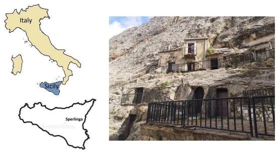
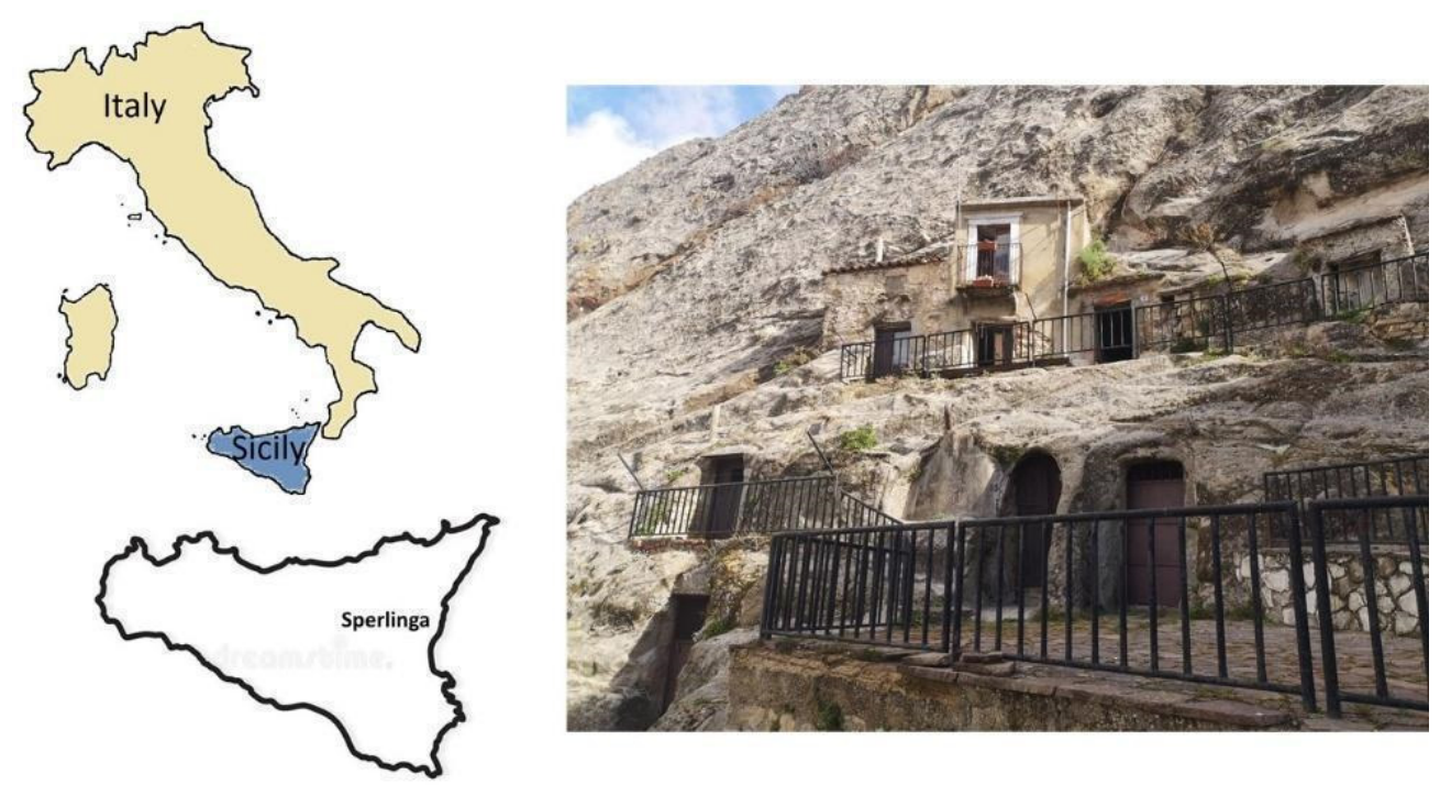
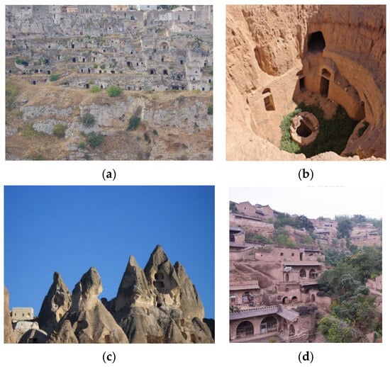
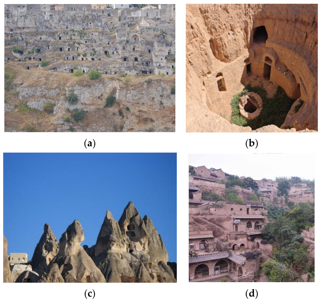
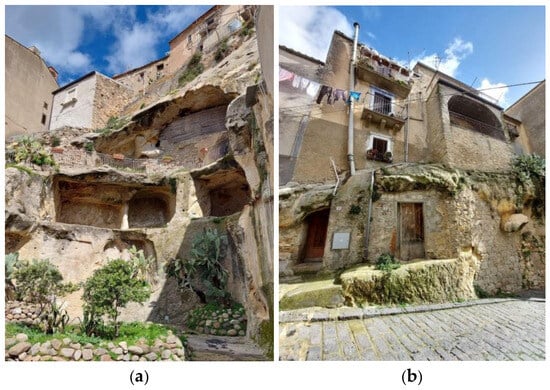
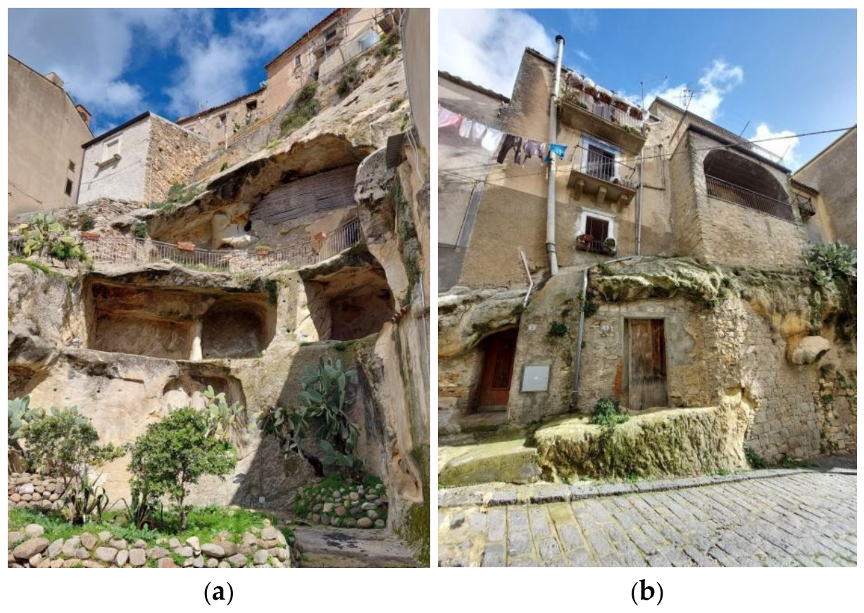
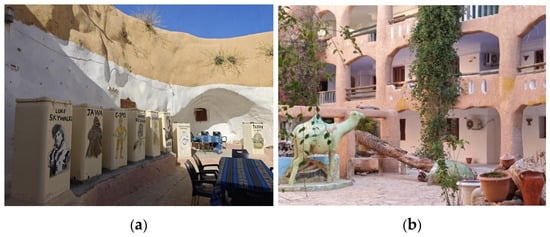
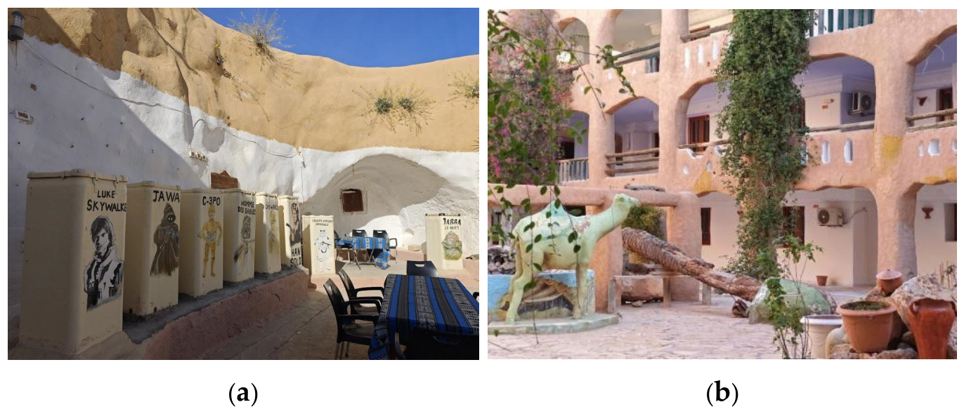
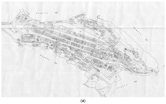
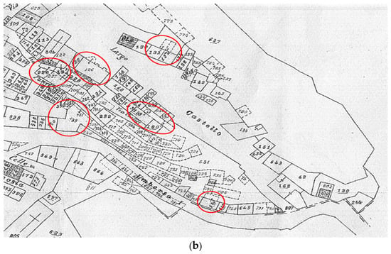
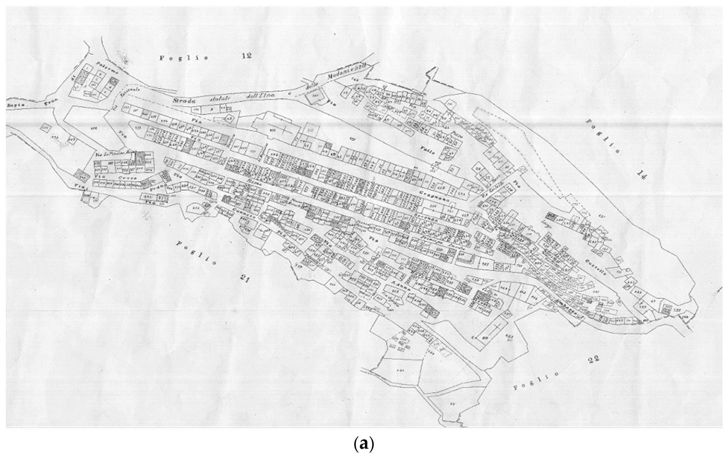
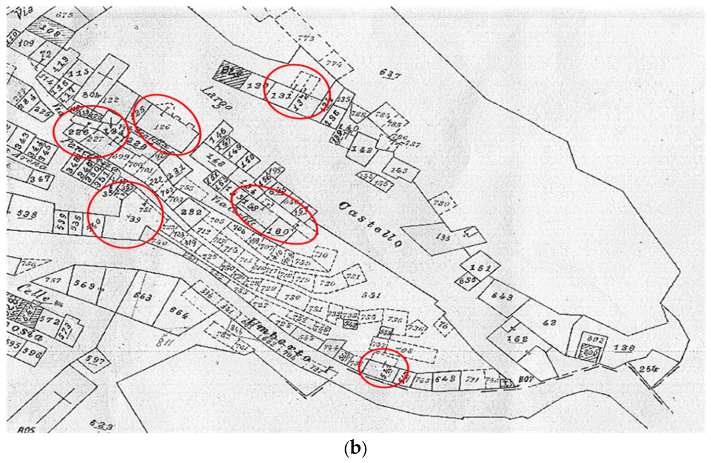
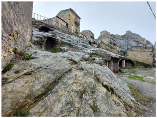
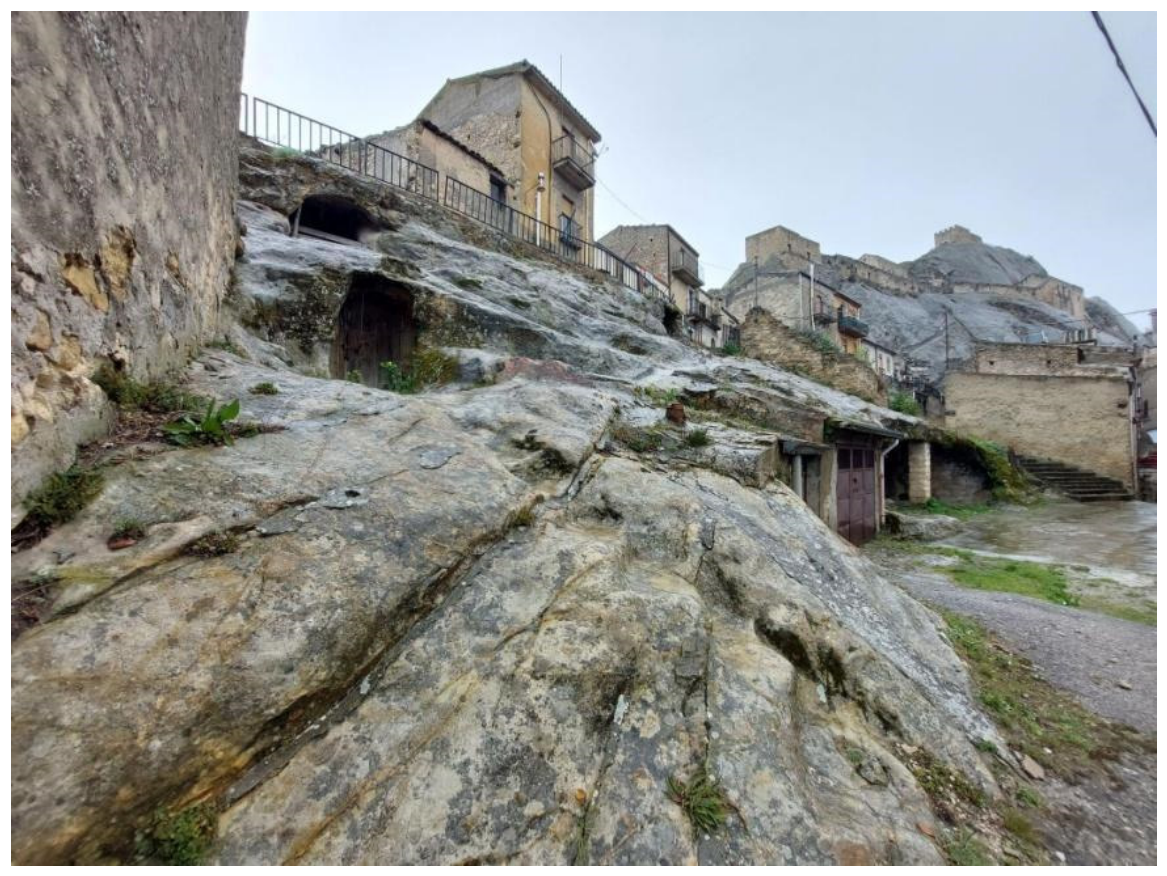
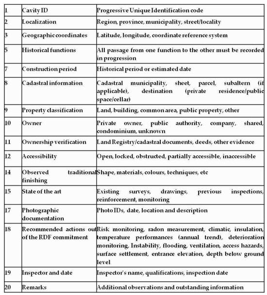
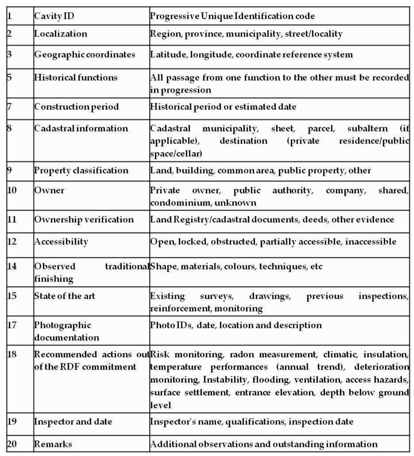
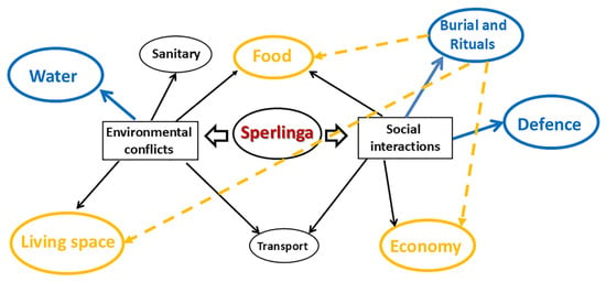
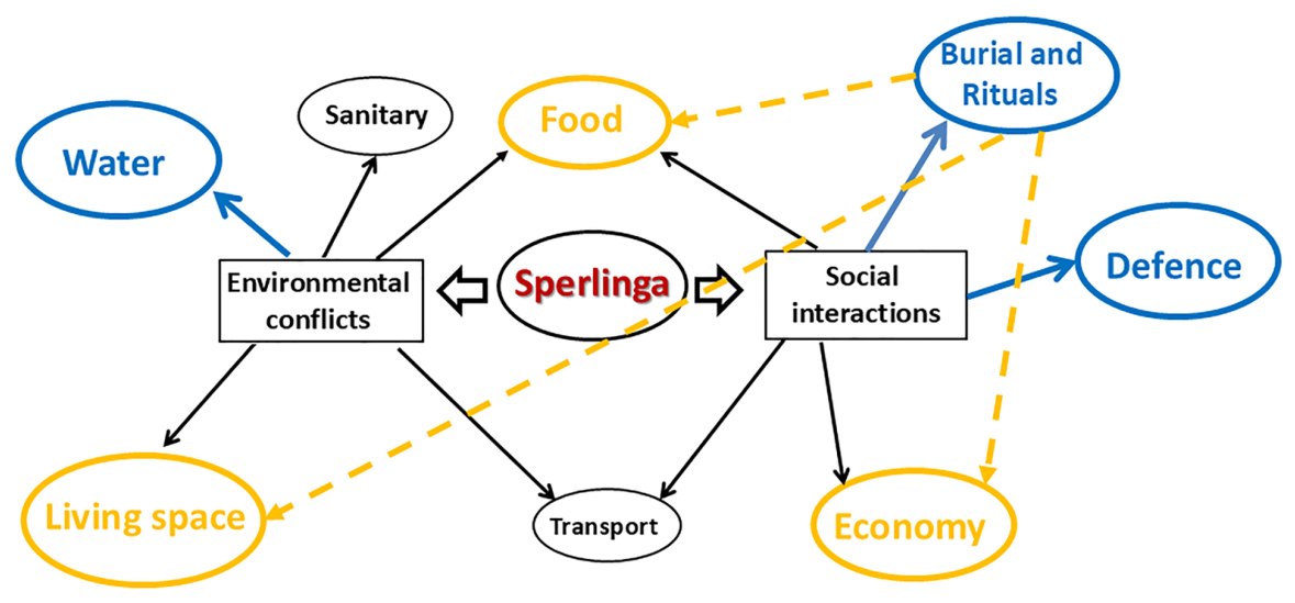
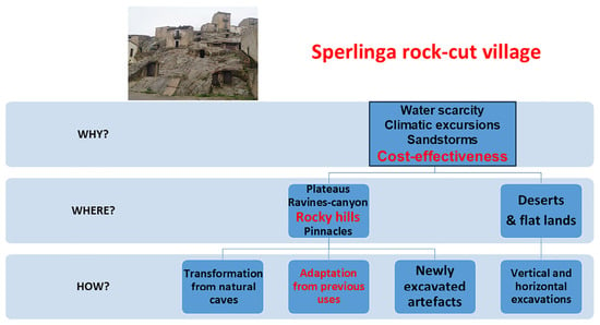
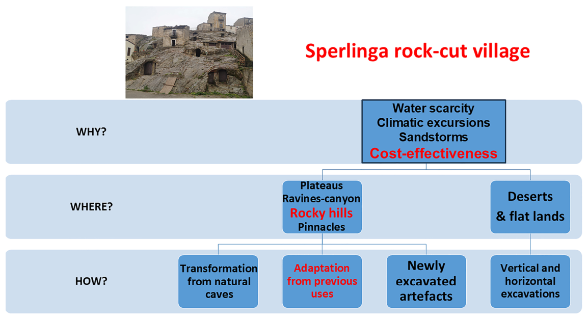
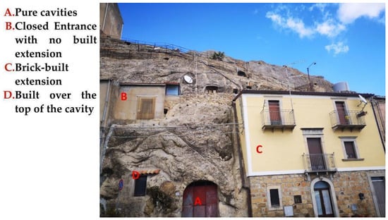
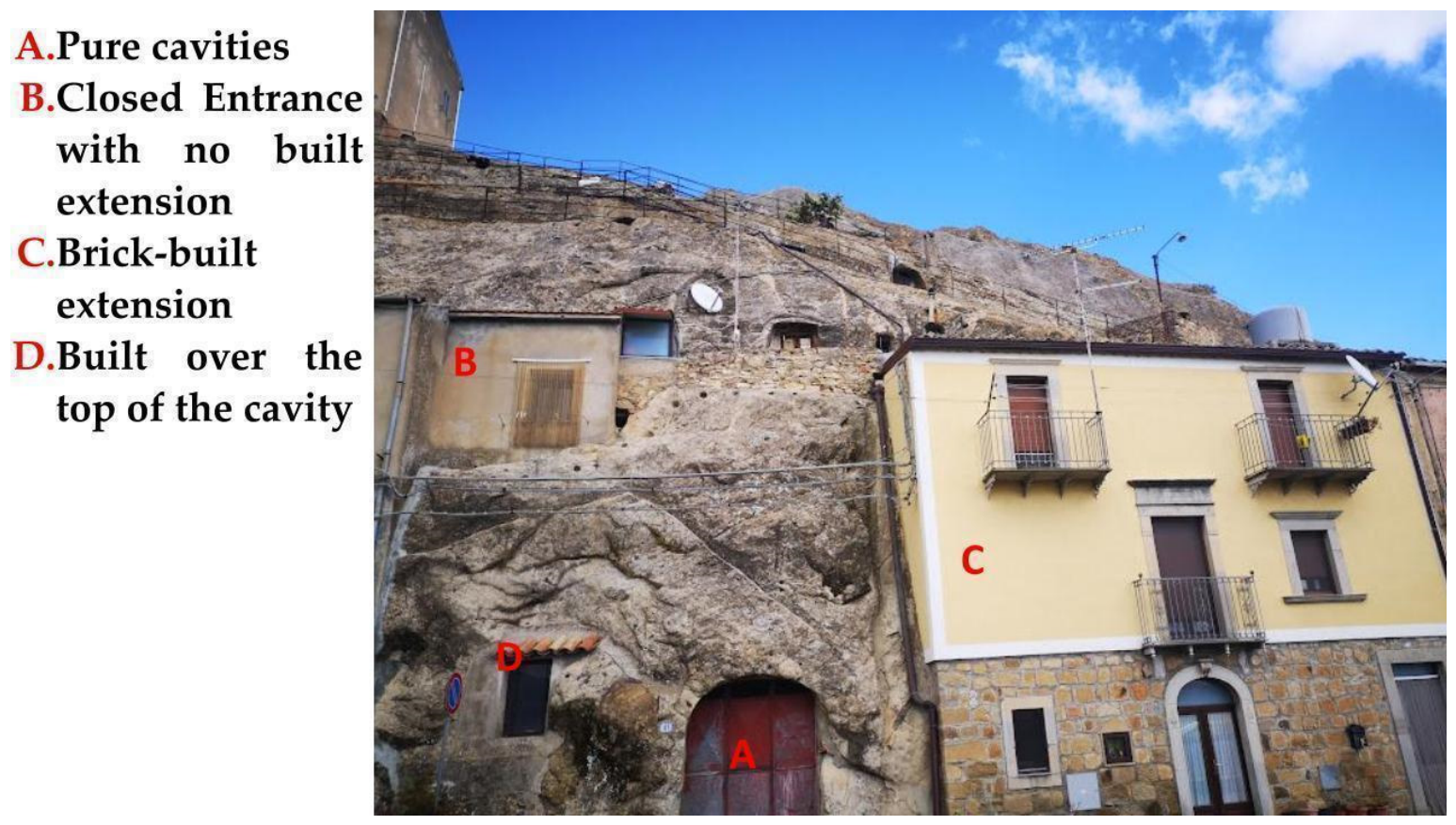
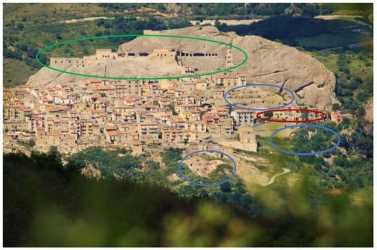
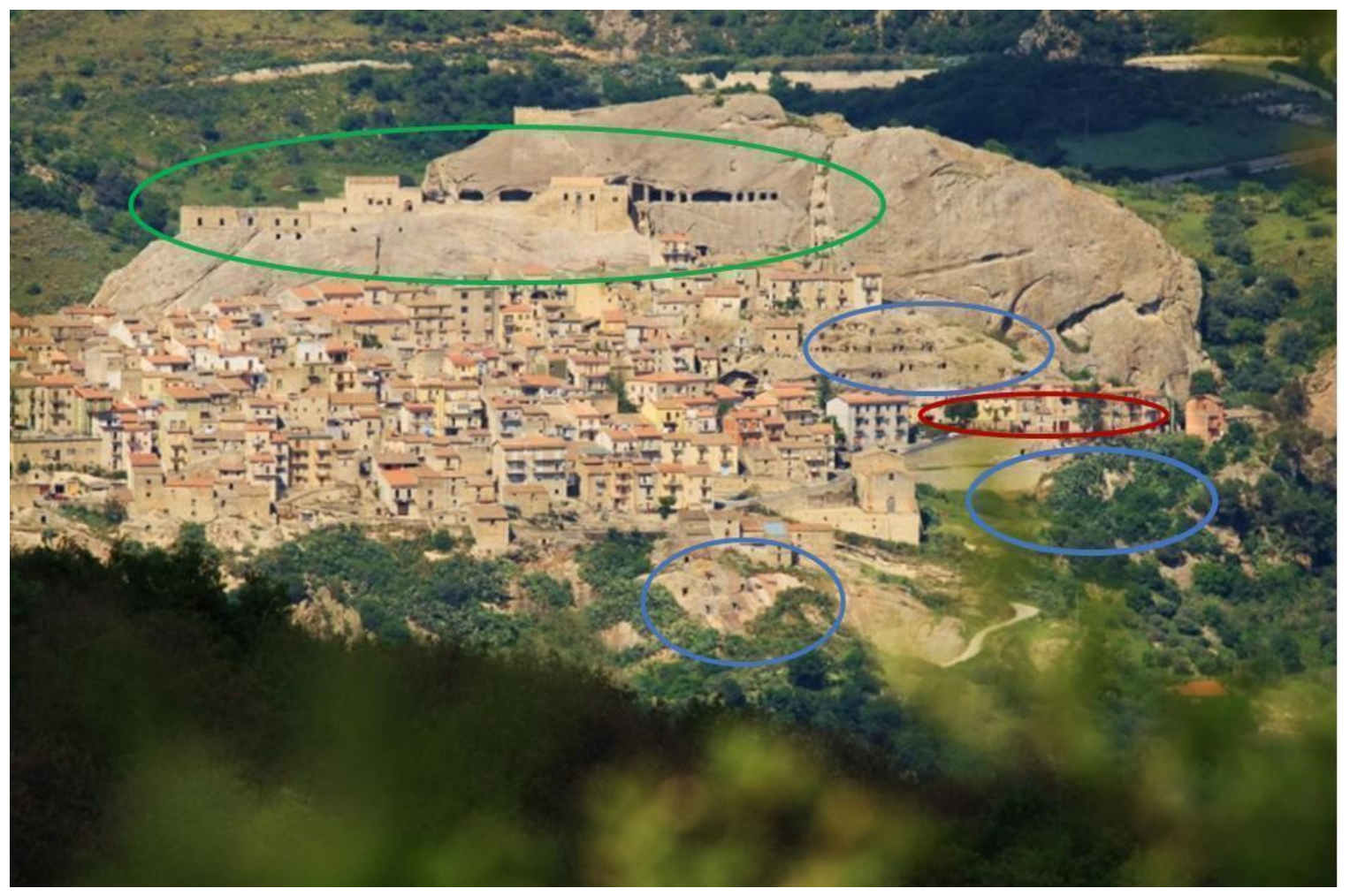
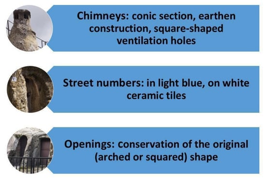
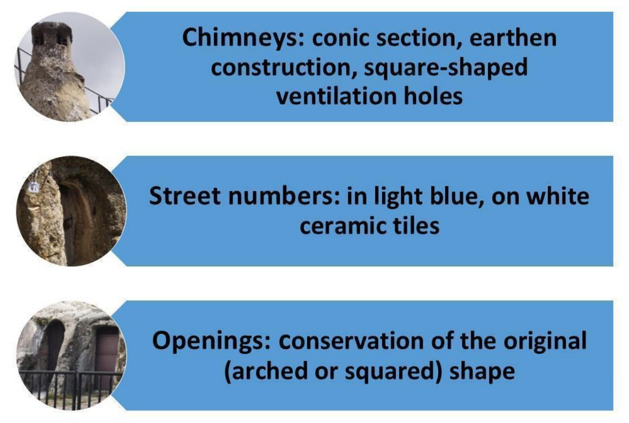
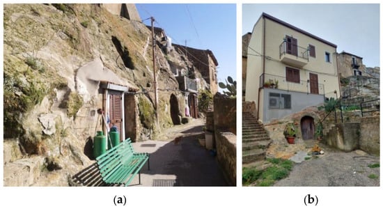
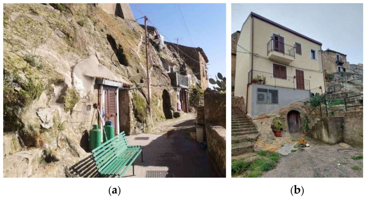
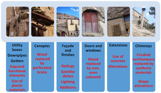
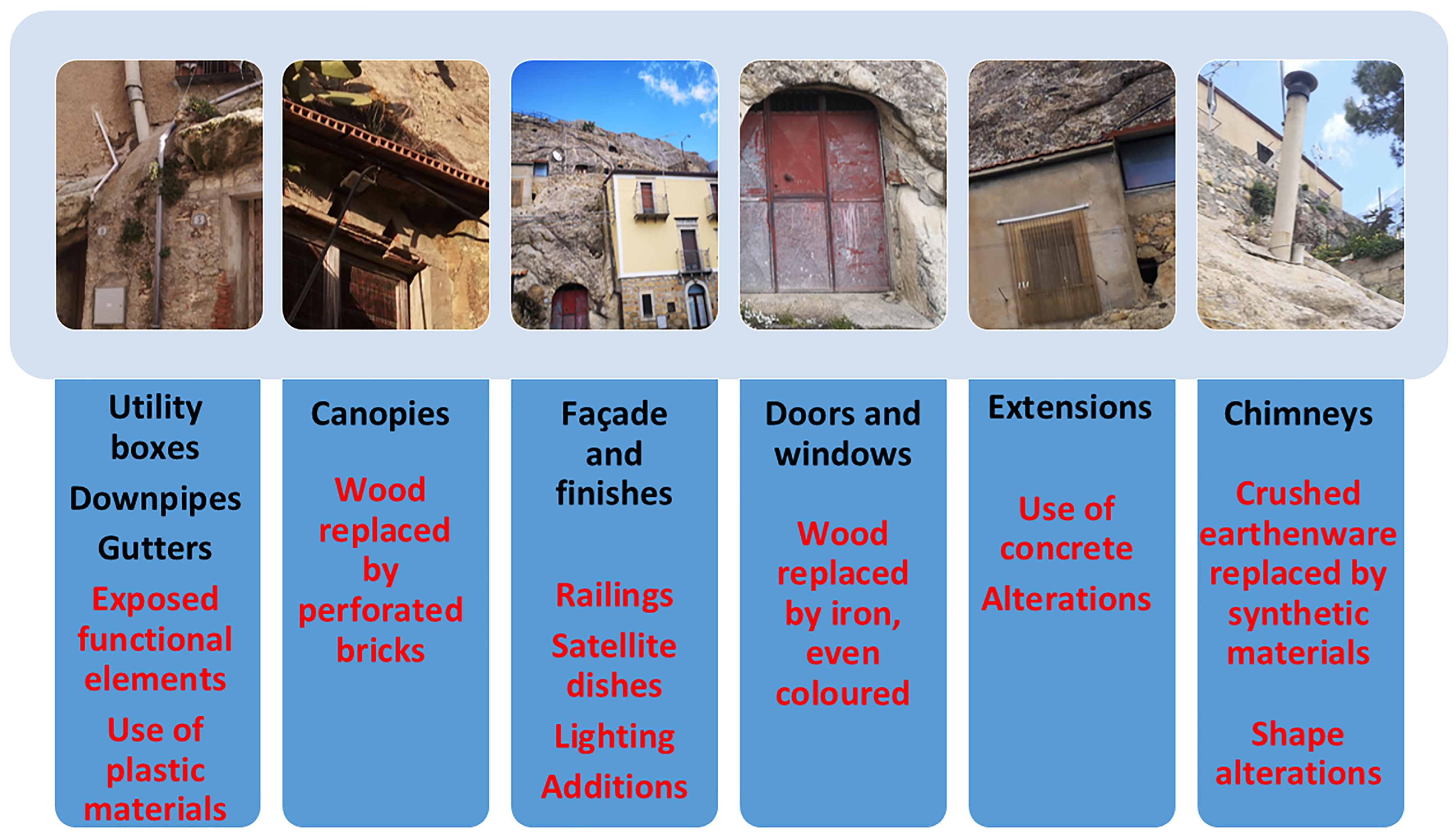
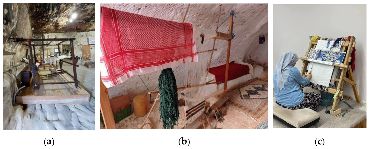

Disclaimer/Publisher’s Note: The statements, opinions and data contained in all publications are solely those of the individual author(s) and contributor(s) and not of MDPI and/or the editor(s). MDPI and/or the editor(s) disclaim responsibility for any injury to people or property resulting from any ideas, methods, instructions or products referred to in the content. |
© 2026 by the authors. Licensee MDPI, Basel, Switzerland. This article is an open access article distributed under the terms and conditions of the Creative Commons Attribution (CC BY) license.