


Abstract
Urban environments are shaped by multisensory experiences in which olfaction plays an important yet often overlooked role. This study investigates the relationship between street morphology and urban smellscape in the city centre of Biskra, Algeria, providing the first empirical smellmapping study conducted in the country. The methodology combines smellwalking with a structured questionnaire to document odour types, perceived intensity, and pleasantness. The collected data were georeferenced and analysed using GIS tools, including point-based olfactory mapping and Inverse Distance Weighted (IDW) interpolation to explore spatial patterns of smell perception. The results reveal that specific odour typologies and levels of pleasantness are closely associated with street configuration and building morphology. Streets with continuous façades and active ground-floor uses exhibit distinctive olfactory identities, whereas traffic-dominated streets tend to generate less pleasant smell environments. These findings highlight the relevance of smellscape analysis for informing urban design and improving sensory qualities of public spaces.
1. Introduction
Urban environments are inherently multisensory environments shaped by the continuous interaction of visual, acoustic, thermal, tactile, and olfactory stimuli. While urban design and architectural research have traditionally focused on visual form and spatial configuration, increasing attention is now being paid to the experiential and perceptual dimensions of urban space. Since early foundational works on urban perception, place identity, and spatial meaning, urban experience has been understood as a complex and embodied phenomenon extending far beyond visual form alone [1,2,3,4,5,6]. While architectural and urban research has traditionally prioritised visual form, geometry, and materiality [1,2], and, more recently, acoustic comfort and soundscape approaches [7,8,9,10,11], the olfactory dimension has remained largely marginal within studies of the built environment.
In parallel, contemporary debates on urban sustainability increasingly emphasise the importance of environmental quality, human well-being, and the experiential dimensions of urban space. Recent urban design research has also highlighted how street configuration, spatial structure, and everyday urban practices shape the quality of public space and influence people’s perception and use of urban environments [12,13,14,15]. Sustainable cities are not only defined by environmental performance but also by the quality of everyday urban environments and their capacity to support healthy, liveable, and human-centred public spaces [16,17,18]. Within this perspective, sensory perception becomes an important component of sustainable urban environments, influencing how people evaluate, use, and appropriate public spaces.
This omission persists despite extensive evidence demonstrating that smells strongly influence well-being, emotional responses, memory, pleasure, place attachment, and everyday spatial practices [19,20,21,22,23,24]. Research in sensory studies, environmental psychology, and cognitive sciences has shown that olfactory perception plays a central role in emotional evaluation, behavioural responses, and the construction of meaning in space [20,21,22,23,24]. Ignoring smell therefore results in a partial and reductionist understanding of urban experience and environmental quality [25,26,27,28].
Within the framework of sensory urbanism, the concept of the urban smellscape was introduced to describe the spatial and temporal organisation of odours and their role in shaping environmental perception and human-environment relationships [19,29,30]. Smellscapes are not accidental by-products of urban life but emerge from the interaction between building morphology, street configuration, land uses, climatic conditions, and everyday human activities [26,29,31,32]. Urban vegetation and green infrastructure can also influence urban smellscapes by introducing natural odours and contributing to improved environmental perception and sensory quality in public spaces. At the scale of streets and blocks, architectural characteristics such as façade continuity, enclosure ratio, street width, and ground-floor functions may influence odour generation, persistence, and dispersion patterns within urban environments [15,31,33,34,35].
Despite this relevance, olfactory perception remains largely absent from architectural and building-scale analyses. Existing studies often approach smells primarily as nuisances related to pollution, sanitation, or odour annoyance [36,37,38,39], rather than as components of spatial atmosphere, place identity, environmental comfort, and urban environmental quality [6,25,26,27,40]. As a result, the analytical potential of smellscape research for understanding and designing the built environment remains underexplored, particularly in relation to street morphology, building configuration, and everyday urban practices.
Recent methodological advances have begun to address this gap through the development of smellwalking, participatory sensory surveys, and GIS-based spatial analysis [31,39,41,42,43]. These approaches enable the documentation and mapping of perceived odour types, intensity, and pleasantness, providing new insights into how urban environments are experienced and evaluated by their users [31,42,43]. Spatial interpolation techniques such as Inverse Distance Weighting (IDW), originally developed for environmental variables, have increasingly been adopted as exploratory tools to visualise spatial tendencies in perceptual and environmental datasets [39,44]. When combined with urban morphology analysis, these methods offer new opportunities to understand how the built environment shapes sensory conditions and environmental quality in cities.
Empirical smellscape research has so far been concentrated mainly in European and East Asian cities, often within temperate climatic contexts [29,31,43]. Studies addressing arid and semi-arid cities remain scarce. Nevertheless, climatic and environmental conditions characteristic of arid regions, including high temperatures, low humidity, and limited vegetation cover, may influence the perception, persistence, and spatial distribution of urban odours, highlighting the need for further smellscape investigations in such contexts [16,29,31]. In Algeria and North Africa more broadly, systematic smellmapping research is virtually non-existent, even though sensory environmental conditions play an important role in the sustainability and liveability of urban environments in hot climates.
This paper addresses these gaps by investigating the relationship between building morphology, street configuration, and urban smellscape in the city centre of Biskra, Algeria. By combining smellwalking, sensory questionnaires, and GIS-based mapping, the study aims to (1) identify dominant urban odours, (2) analyse their spatial distribution and perceptual qualities, and (3) examine how architectural and morphological parameters shape urban smellscapes in an arid context. Through this approach, the study contributes new empirical evidence to the emerging field of urban smellscape research and demonstrates how the integration of sensory mapping, GIS analysis, and urban morphology can support the design of environmentally sustainable, human-centred, and sensory-aware street environments in arid cities.
2. Literature Review
2.1. Smellscape and Sensory Urbanism
The notion of the smellscape was originally introduced to describe the spatial organisation of odours and their role in shaping environmental perception and human–environment relationships [19]. Unlike visual or acoustic phenomena, smells are often diffuse, transient, and strongly embedded in everyday practices, making them particularly significant for the lived experience of urban space [20,32]. Early smellscape research highlighted the capacity of odours to structure mental maps, evoke memories, and contribute to the symbolic and cultural identity of places [3,19,32].
Subsequent studies have demonstrated that smells play a critical role in place identity, emotional responses, and behavioural patterns in urban environments [20,21,23,41]. Pleasant odours, such as food-related smells, vegetation, or traditional products, are often associated with social interaction, attachment, and positive place evaluation [21,29,41,45], while unpleasant odours such as sewage, waste, or traffic emissions tend to generate discomfort, avoidance behaviours, and negative environmental judgements [11,25,39]. These perceptual effects are not merely sensory but are mediated by cultural background, personal experience, and social meaning [21,32].
Within the broader framework of sensory urbanism, the smellscape is understood as one component of a multisensory environment in which vision, sound, touch, and smell interact dynamically [27,32,37]. Architectural theorists and urban scholars have increasingly argued that an exclusive focus on visual form leads to a partial and reductionist understanding of space [27,32,38]. Sensory approaches emphasise the embodied and multisensory experience of buildings and streets, recognising the human body as an active sensor that continuously negotiates environmental stimuli [27,32]. In this perspective, smells are not marginal or accidental but constitute an integral dimension of spatial atmosphere and environmental quality [27,37].
In recent years, smellscape research has expanded beyond descriptive accounts to explore broader questions related to sustainability, well-being, and environmental quality in urban environments [16,29,41,43]. Odours are increasingly considered indicators of environmental quality and urban metabolism, reflecting patterns of production, consumption, and infrastructure [16,39]. As such, the analysis of smellscapes offers valuable insights into how urban environments are experienced and evaluated by their users, particularly in dense and climate-sensitive contexts [29,31,41,43].
Urban perception and place experience have also been extensively discussed in foundational urban theory and design studies addressing legibility, social life, spatial meaning, and everyday practices beyond sensory dimensions alone [1,2,4,5,6,12,46,47,48,49].
2.2. Smellwalking as a Research Method
Smellwalking has emerged as a key qualitative method for investigating urban smellscapes and documenting olfactory experience in situ [42]. The method involves focused walks during which participants consciously attend to, identify, describe, and evaluate odours encountered along predefined or exploratory urban routes [20,42]. By slowing down perception and directing attention toward smell, smellwalking enables the capture of sensory information that is often overlooked in everyday movement [20,42].
One of the main strengths of smellwalking lies in its ability to document fleeting, context-dependent, and embodied sensory experiences that are difficult to measure using conventional instruments [21,42]. Odours vary according to time of day, weather conditions, human activity, and spatial configuration, making direct sensory engagement essential for understanding their spatial logic [42,43]. Smellwalking therefore complements more technical environmental measurements by foregrounding perception and lived experience [20,21].
Recent studies have combined smellwalking with participatory and survey-based approaches, allowing participants to record smell notes, evaluate intensity, and assess pleasantness using descriptive language and numerical scales [29,41,43,45]. This hybridisation enhances methodological robustness by enabling partial quantification while preserving the subjective nature of olfactory perception [29,41,43]. In addition, participatory smellwalking has been used as a tool for public engagement, raising awareness of sensory environments and encouraging reflection on urban quality and sustainability [41,45].
From an architectural and urban design perspective, smellwalking is particularly relevant at the scale of streets and buildings, where spatial enclosure, façade continuity, and ground-floor activities strongly influence olfactory experience [26,31,50]. As such, smellwalking provides a valuable methodological bridge between sensory perception and the analysis of built form [26,31].
2.3. GIS-Based Olfactory Mapping
The integration of smellscape research with Geographic Information Systems (GIS) has significantly advanced the spatial analysis and visualisation of olfactory perceptions [42,43,51]. GIS-based olfactory mapping allows sensory data collected through smellwalking and surveys to be georeferenced and analysed in relation to urban form, land use, and infrastructure [32,43]. Common techniques include point mapping of perceived odours, density analysis, and interpolation methods such as Inverse Distance Weighting (IDW) [32,43].
Although olfactory perception is not a continuous physical variable, GIS-based representations provide valuable heuristic tools for exploratory analysis [39,42,43,51]. Point-based maps highlight the spatial distribution of odour sources and perceptions, while interpolation techniques help visualise gradients and zones of influence [32,43]. IDW, in particular, has been widely used in exploratory smellscape studies because it emphasises local influence and spatial proximity, which align with human sensory perception [43].
Several authors have noted the limitations of applying quantitative spatial models to perceptual data, especially when variance is low or when odours are diffuse rather than point-based [32,42,51]. However, rather than being seen as methodological weaknesses, these limitations underline the importance of interpreting GIS outputs in conjunction with qualitative observations and contextual knowledge [32,42,43]. When combined with smellwalking and field observation, GIS-based olfactory mapping offers a powerful framework for linking perception, space, and urban morphology [31,43].
Spatial interpolation techniques such as IDW are well established in environmental and spatial analysis and have recently been applied in public health and environmental quality studies, supporting their use as exploratory analytical tools [39,44].
2.4. Building Morphology and Environmental Perception
A growing body of research published in Buildings and related journals has demonstrated that building morphology and street configuration significantly influence environmental perception, including thermal comfort, acoustic quality, walkability, and overall environmental satisfaction [15,26,31,50]. Parameters such as building height, street width, enclosure ratio, façade continuity, and ground-floor uses shape microclimatic conditions, patterns of movement, and sensory exposure at the street level [15,26,31].
From an olfactory perspective, building morphology may influence odour accumulation, persistence, and dispersion patterns [29,31,43]. Narrow streets with continuous façades may trap odours and intensify sensory experience, while wider streets and open configurations tend to promote ventilation and odour dilution [26,39]. Ground-floor functions such as food preparation, markets, workshops, or traffic infrastructure directly influence the type and intensity of smells perceived by users [29,31,43].
Despite these evident relationships, the olfactory dimension remains largely absent from morphological and building-scale analyses [11,39]. Most existing studies focus on visual, thermal, or acoustic parameters, with smell considered only indirectly as a nuisance or environmental problem [39]. This study extends current research by explicitly integrating the smellscape into the analysis of building and street morphology, thereby contributing to a more comprehensive and multisensory understanding of the built environment [27,32].
By bridging smellscape research, GIS-based analysis, and architectural morphology, this literature review establishes a conceptual foundation for analysing potential relationships between urban form and olfactory experience in arid urban contexts [16,29,31,43].
Recent urban design research has further emphasised the role of street configuration, spatial structure, and everyday urban practices in shaping the experiential quality of public space. These studies highlight how street morphology, spatial hierarchy, and the organisation of ground-floor activities influence environmental perception, pedestrian experience, and the overall quality of urban environments. By focusing on the relationship between urban form and human experience, this body of research reinforces the importance of integrating perceptual and multisensory dimensions into urban design analysis, moving beyond purely visual interpretations of the built environment [13,14]. International standards and institutional reports further support the integration of sensory and environmental quality considerations into urban and building design practices [10,16,36].
3. Study Area and Case Study Context
3.1. Climatic and Functional Characteristics
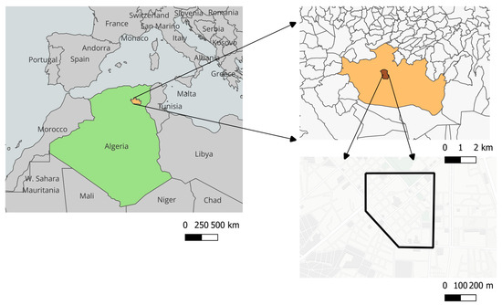
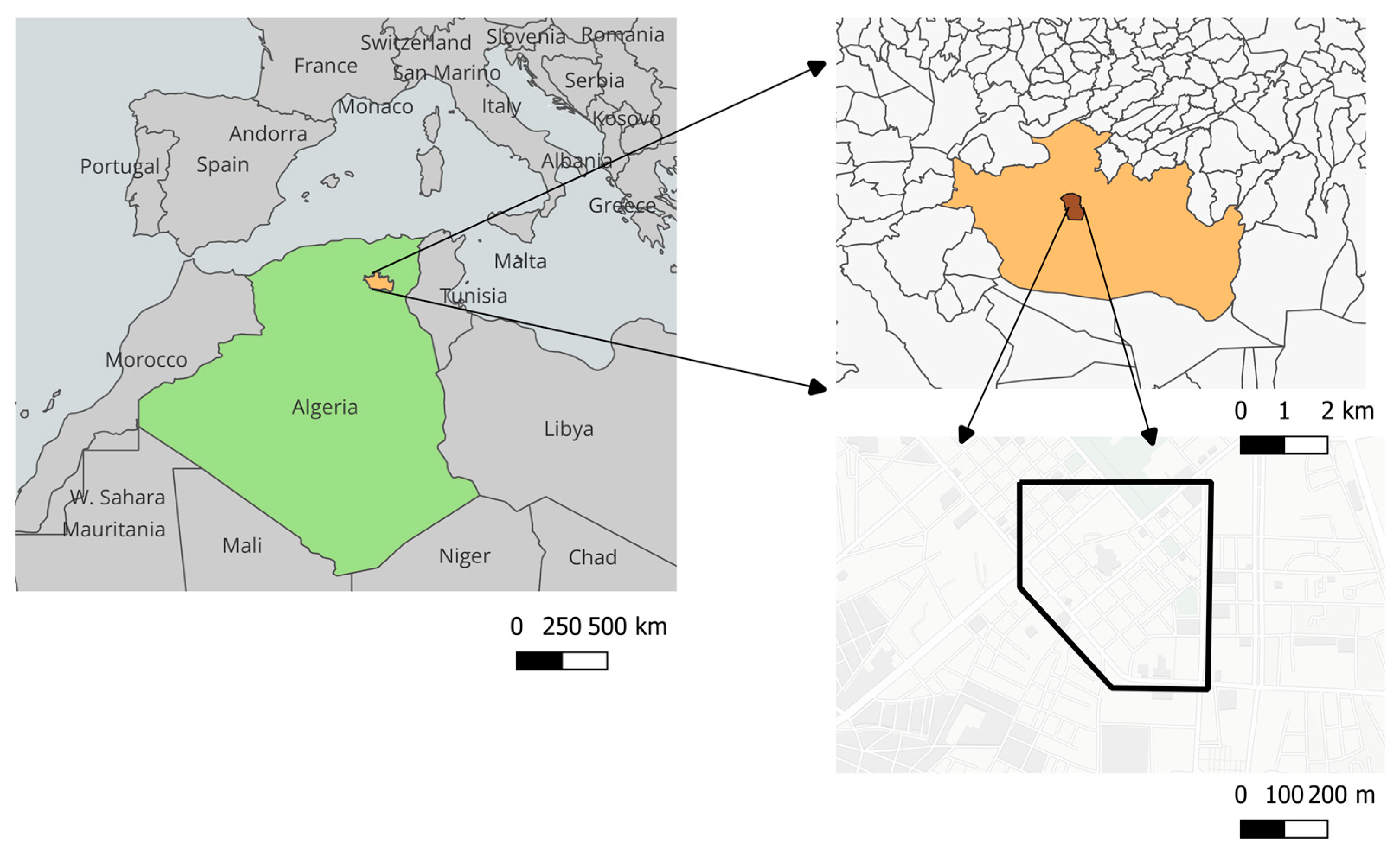
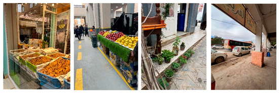
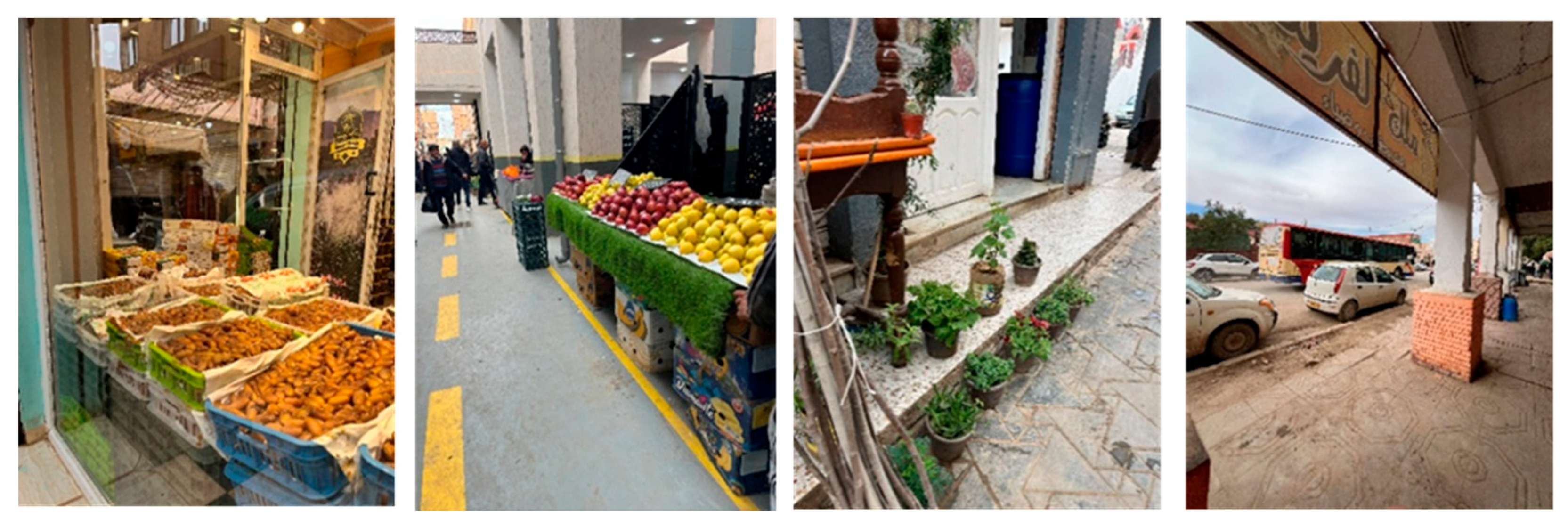
Located in southeastern Algeria, Biskra is characterised by a hot arid climate, marked by high temperatures, strong solar exposure, and limited rainfall. These climatic conditions play a significant role in odour persistence and dispersion, reinforcing the impact of urban form and street morphology on olfactory perception (Figure 1). The city centre combines administrative functions, traditional markets, food-related activities, traffic corridors, and public spaces, creating a complex and layered sensory environment suitable for smellscape investigation (Figure 2).
Figure 1.
Geographical location of the case study area (Biskra, Algeria).
Figure 2.
Photographic views of the case study area illustrating everyday urban activities and potential sources of olfactory perception in the city centre of Biskra, including a shop sign displaying the Arabic expression “Malik al-Frit” (“King of Fried Snacks”), referring to a fried-food vendor.
3.2. Historical and Urban Development of Biskra
The city of Biskra acquired its modern urban form from 1844 onwards, following the French occupation and the establishment of Fort Saint-Germain outside the palm grove [52]. From 1855, civilian colonisation was organised according to an orthogonal grid plan designed by the military engineering corps. Inspired by Roman urban models, this plan was based on principles of rationality, control, and spatial legibility, which characterised many colonial urban interventions in North Africa [53,54].
This newly planned urban development introduced a clear rupture between three distinct entities: the colonial city, the indigenous settlement, and the oasis. Each of these components generated specific urban atmospheres and environmental conditions [53,55]. The colonial grid, composed of regular blocks and rectilinear streets oriented north south and east west, structured an open, mineral, and well-ventilated urban space. This morphology contrasted sharply with the denser and more compact traditional urban fabrics, characterised by narrow streets and enclosed spatial configurations typical of pre-colonial settlements in arid contexts [56,57].
Institutional and commercial axes, particularly those surrounding the central market and main streets, became focal points for economic activity, social interaction, and daily urban life [46]. These streets concentrated commercial functions, food-related activities, and intense pedestrian flows, contributing to distinctive sensory and olfactory environments [29,31].
This hierarchically organised spatial structure has had a lasting influence on urban uses, everyday practices, and environmental perception. In particular, it may contribute to variations in the distribution, persistence, and perception of urban odours, resulting in differentiated smellscapes between the oasis, the colonial grid, and areas of commercial centrality. These contrasts make Biskra a highly relevant case study for exploring the relationship between urban morphology, street configuration, and sensory experience, especially in an arid climatic context [16,29,31].
4. Materials and Methods
This research adopts a mixed-methods approach combining qualitative sensory investigation and quantitative spatial analysis, a strategy widely used in sensory urban studies to capture both experiential and spatial dimensions of environmental perception [29,42,43]. Qualitative methods capture the subjective and experiential nature of olfactory perception, while GIS-based spatial analysis enables the exploration of spatial patterns and their relationship with building morphology and street configuration [31,39]. This combination enhances the robustness and interpretability of smellscape analysis at the street and building scale [29,43].
4.1. Research Methodology Framework
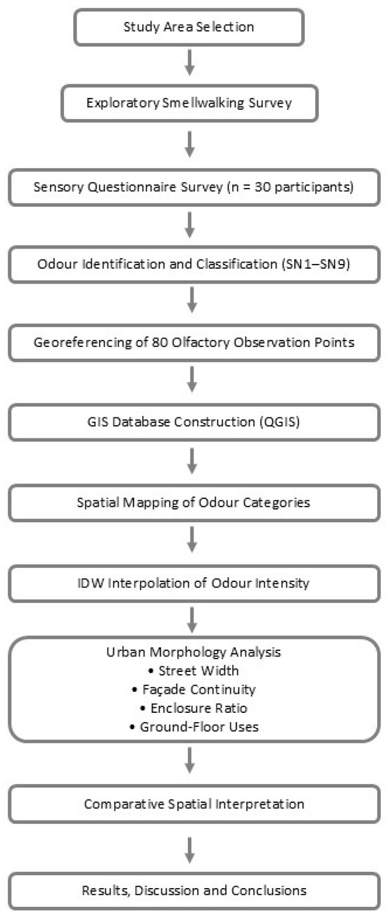
This study adopted an exploratory mixed-methods framework to investigate the relationship between urban smellscapes, street morphology, and sensory perception in the city centre of Biskra, Algeria. The methodological approach combined qualitative sensory investigation with GIS-based spatial analysis in order to capture both the experiential and spatial dimensions of urban olfactory environments.
The research was conducted through a sequence of complementary stages. First, an exploratory smellwalking survey was undertaken by the research team to identify, document, and classify dominant odour characteristics within the study area. During this stage, olfactory observations were recorded at 80 georeferenced sampling points distributed throughout the city centre. Second, a structured sensory questionnaire was administered on 2 February 2026 to 30 participants, including residents, tourists, and regular users of the city centre, in order to collect information regarding odour perception, intensity, and pleasantness. Third, the collected olfactory data were classified into thematic odour categories reflecting the main environmental and urban activities observed in the study area.
Subsequently, all observation points were integrated into a Geographic Information System (GIS) environment using QGIS 3.40.14 software. GIS tools were employed for data management, spatial visualisation, thematic mapping, and the generation of interpolated olfactory intensity surfaces. To explore local spatial tendencies in odour perception, an Inverse Distance Weighting (IDW) interpolation was performed. The resulting smellscape maps were then compared with urban morphology characteristics, including street width, façade continuity, enclosure ratio, and dominant ground-floor land uses.
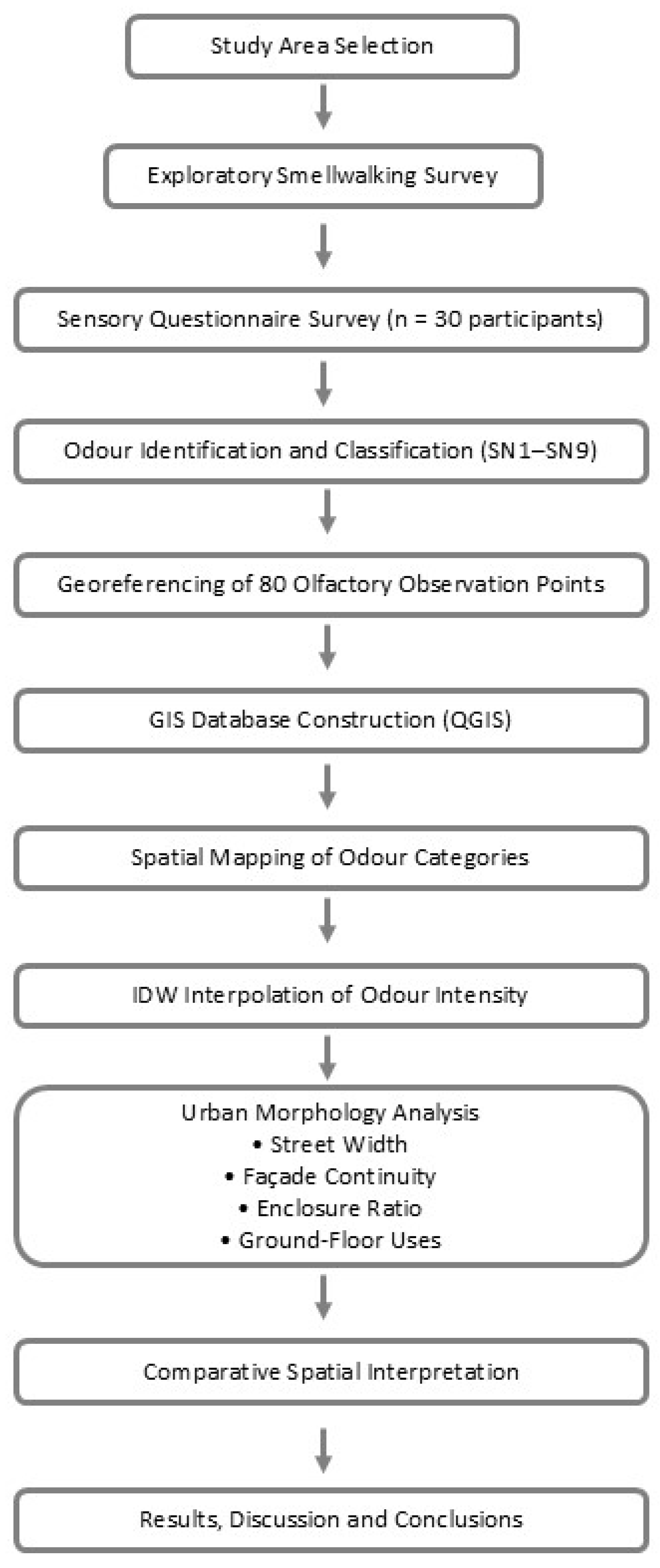
The overall methodological workflow is presented in Figure 3. This framework was designed to support an exploratory interpretation of smellscape patterns and their potential association with urban form rather than to establish deterministic causal relationships. The IDW interpolation should therefore be understood as a spatial visualisation tool intended to represent recurrent perceptual tendencies and local variations in olfactory intensity rather than as a deterministic model of odour dispersion.
Figure 3.
Research workflow adopted for smellscape mapping and urban morphology analysis in the city centre of Biskra.
4.2. Exploratory Smellwalking and Sensory Questionnaire Survey
An initial exploratory smellwalking campaign was conducted along main and secondary streets within the study area to identify and characterise the urban smellscape. Smellwalking is a recognised qualitative method for documenting in situ olfactory experience and directing attention toward everyday sensory environments [41,42]. During these walks, odours were systematically detected, described using smell notes, and classified into locally relevant odour categories, following established smellscape research practices [29,41].
Based on the smellwalking results, a structured sensory questionnaire was administered to residents and regular users of the city centre. Participants were asked to identify perceived odour types at specific locations, evaluate perceived olfactory intensity using a seven-point scale, and assess pleasantness through a bipolar scale, as commonly applied in participatory smellscape and sensory perception studies [29,41,43,45]. The combined use of exploratory smellwalking and questionnaire-based evaluation ensured consistency between in situ sensory observations and user perceptions, strengthening the reliability of the collected olfactory data [42,43].
4.3. Odour Classification Framework
Based on the exploratory smellwalking and the sensory questionnaire survey, perceived odours were classified into nine main odour families (SN1–SN9) reflecting locally relevant urban activities and environmental conditions (Table 1). Similar classification approaches have been adopted in previous smellscape studies to structure qualitative sensory data and support spatial analysis [29,31,43]. Each odour family was defined using typical smell notes and example descriptors reported by participants and was associated with likely sources observed in the district, such as ground-floor commercial activities, traffic infrastructure, vegetation, or waste management practices.
Table 1.
Classification of perceived urban odour families and associated sources.
The classification distinguishes between pleasant, unpleasant, and mixed valence odours, acknowledging the subjective and context-dependent nature of olfactory perception [20,21]. Food-related, fruit, tea, date, vegetation, and herbal odours were generally perceived as pleasant and closely linked to traditional commercial streets and everyday social practices, consistent with previous findings in urban smellscape research [29,45]. In contrast, traffic-related, waste, and animal odours were predominantly evaluated as unpleasant and associated with vehicular corridors, unmanaged spaces, or informal activities [37,39]. This odour classification framework provided the basis for subsequent spatial mapping, intensity analysis, and interpretation of urban smellscapes in relation to street morphology and building configuration [29,31].
4.4. Participants and Data Collection
Fieldwork was conducted on 2 February 2026 in the city centre of Biskra. Data collection was carried out under typical daytime winter conditions in Biskra. Weather conditions were stable during the survey period, minimising the influence of short-term atmospheric variations on odour perception. The data collection process consisted of two complementary stages: an exploratory smellwalking survey and a questionnaire-based sensory assessment.
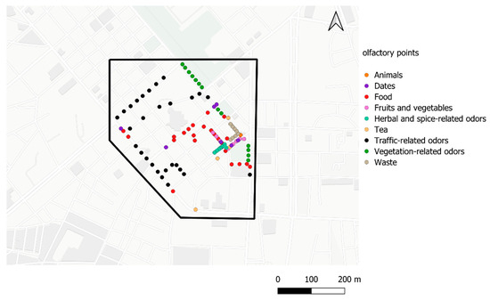
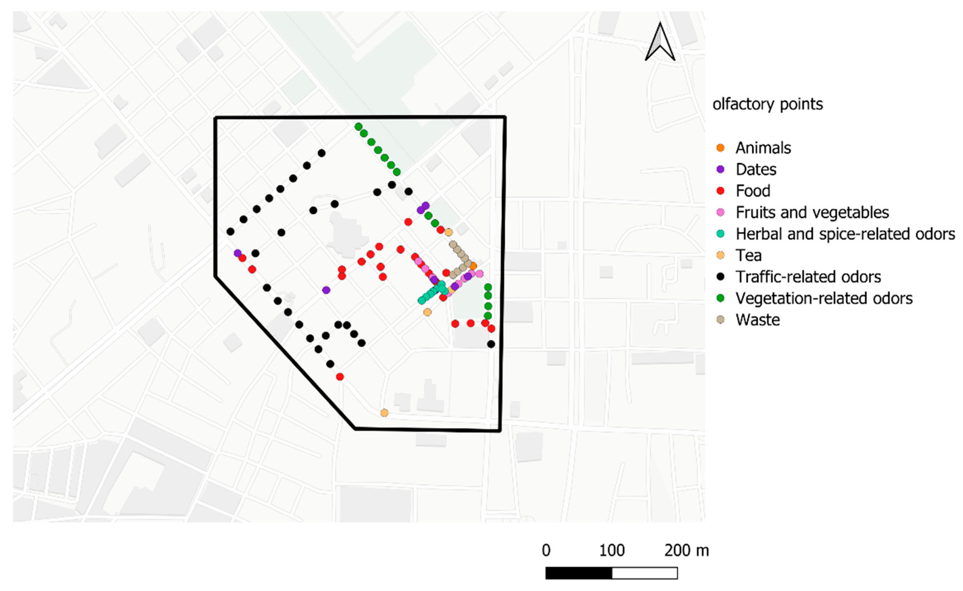
The exploratory smellwalking survey was undertaken by the research team in order to identify, document, and classify the dominant odour characteristics of the study area. During this stage, a total of 80 olfactory observation points were recorded and georeferenced throughout the city centre. The observation points were distributed across the study area to ensure coverage of the main street typologies, commercial zones, traffic corridors, public spaces, and areas identified during the preliminary field survey as exhibiting distinct olfactory characteristics. The spatial distribution of these observation points is presented in Figure 4.
Figure 4.
Spatial distribution of olfactory sampling points in the city centre of Biskra.
Following the exploratory survey, a structured sensory questionnaire was administered to 30 participants were recruited through convenience sampling among individuals present within the study area during the survey period. The sample was intentionally composed of residents, regular users, and visitors in order to capture a diversity of experiences and perceptions of the urban environment. Participants were invited to identify dominant odours perceived at selected locations, evaluate odour intensity using a seven-point scale ranging from 1 (very weak) to 7 (very strong), and assess odour pleasantness through a bipolar evaluation scale. The complete questionnaire used in this study is provided in Supplementary Material S1.
Prior to participation, respondents received a brief explanation of the survey objectives and the odour evaluation procedure. The combination of expert-led smellwalking observations and user-based sensory evaluations enabled the integration of both observed and perceived dimensions of the urban smellscape, thereby strengthening the interpretation of olfactory patterns within the study area.
4.5. GIS-Based Spatial Analysis
All spatial analyses were performed within a Geographic Information System (GIS) environment using QGIS software. Following data collection, the olfactory observation points identified during the smellwalking survey were georeferenced and integrated into a spatial database. This database served as the basis for the production of thematic maps illustrating the distribution of odour categories and perceived olfactory intensity across the study area.
To investigate spatial tendencies in odour perception, an Inverse Distance Weighting (IDW) interpolation was applied to the intensity ratings collected during the sensory survey. Odour intensity was evaluated using a seven-point scale ranging from 1 (very weak) to 7 (very strong). The resulting interpolated surface was used to visualise local variations in perceived olfactory intensity and to identify recurring spatial patterns within the city centre.
The IDW interpolation was employed as an exploratory spatial visualisation technique rather than as a deterministic model of odour dispersion. Given the subjective nature of perceptual data, the resulting surface should be interpreted as a representation of recurrent sensory tendencies and spatial associations rather than as a direct measurement of environmental conditions. The interpolated maps were subsequently compared with urban morphology characteristics to support the interpretation of smellscape patterns observed within the study area.
4.6. Urban Morphology Analysis
Urban morphology was analysed to explore the potential relationship between street configuration and the spatial distribution of olfactory perceptions. Particular attention was given to morphological characteristics commonly associated with microclimatic conditions, pedestrian movement, and sensory exposure at the street level.
The analysis focused on four principal indicators: street width, façade continuity, enclosure ratio, and dominant ground-floor land uses. These indicators were evaluated through field observations, photographic documentation, and cartographic interpretation of the study area.
Based on the observed morphological characteristics, urban spaces within the city centre were classified into three categories: dense urban fabric, semi-dense urban fabric, and open urban fabric. Dense urban fabrics were characterised by relatively narrow streets, continuous building frontages, and a higher degree of spatial enclosure. Semi-dense urban fabrics represented transitional environments exhibiting moderate enclosure and mixed spatial permeability. Open urban fabrics were characterised by wider streets, greater openness, and increased airflow potential.
This morphological classification provided a spatial framework for interpreting smellscape patterns and comparing the distribution of perceived odour intensity with different urban configurations. The resulting morphology map was subsequently compared with the GIS-based smellscape maps in order to support an exploratory interpretation of the relationship between urban form and olfactory perception. The morphology analysis adopted in this study was primarily based on qualitative field observations and exploratory interpretation of urban form characteristics rather than on quantitative morphological measurements. Consequently, the dense, semi-dense, and open urban fabric categories should be understood as interpretative classifications intended to support the comparison between urban morphology and observed smellscape patterns. The resulting interpretations identify potential spatial associations rather than statistically verified or causal relationships.
5. Results
5.1. Spatial Mapping of Olfactory Perception
Survey responses were georeferenced and analysed using QGIS. Point-based olfactory maps were produced, and IDW interpolation was applied to perceived intensity values to visualise spatial patterns of olfactory perception, as commonly applied in GIS-based smellscape and environmental perception studies [39,42].
Point-based olfactory map (Figure 4) shows the spatial distribution of dominant odour typologies identified through smellwalking and sensory questionnaires. Food-related, herbal, tea, and fruit odours are mainly concentrated along traditional commercial streets and market areas, reflecting active ground-floor uses and high pedestrian activity, as reported in previous smellscape studies [29,31]. In contrast, traffic- and waste-related odours are predominantly associated with major circulation axes and infrastructural corridors, highlighting the relationship between street function, building morphology, and perceived olfactory character.
5.2. Spatial Distribution of Smell Intensity and Pleasantness
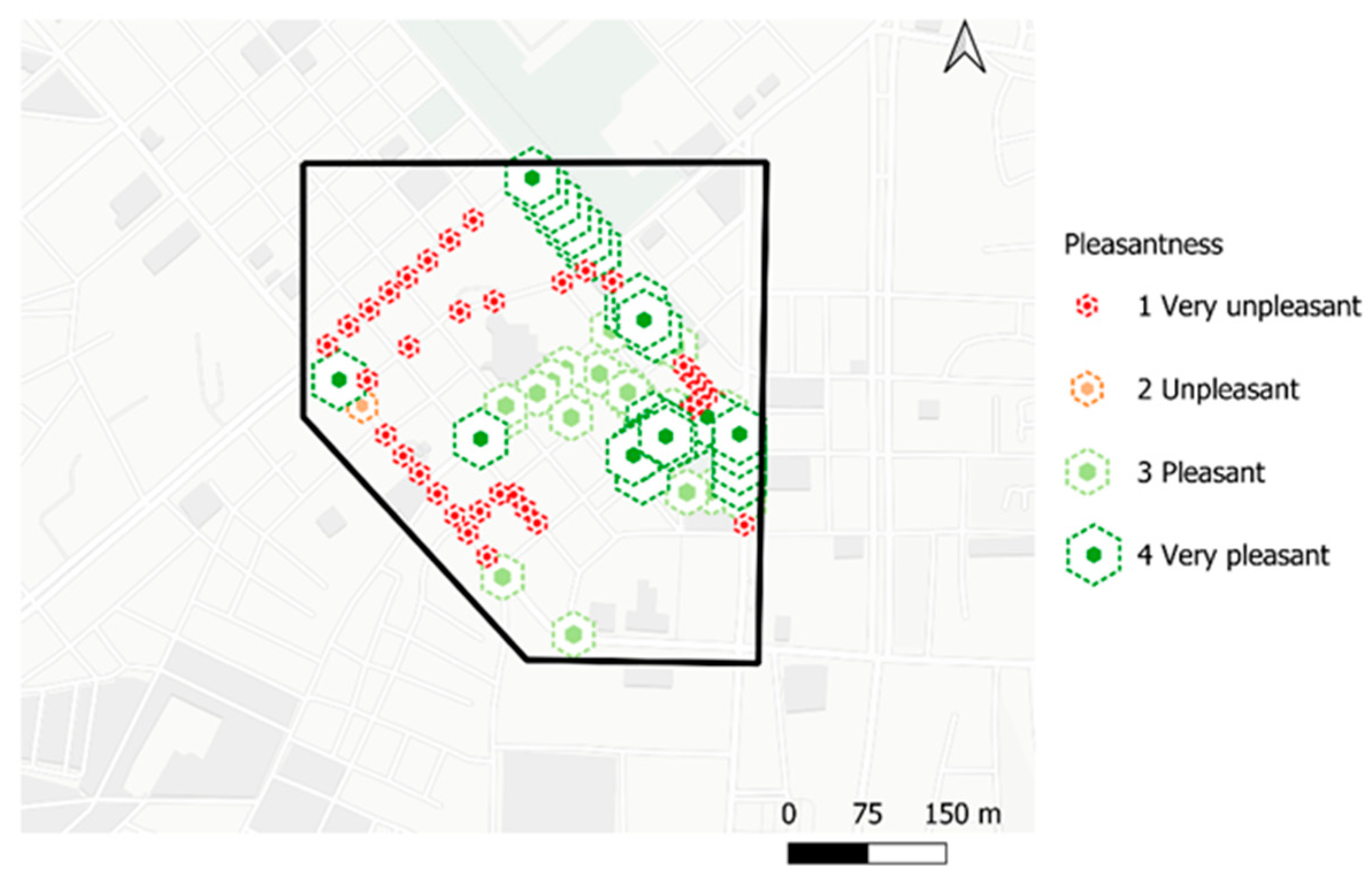
The pleasantness map (Figure 5) reveals a clear spatial differentiation in the qualitative evaluation of urban odours across the city centre of Biskra. Areas characterised by traditional commercial activities and active ground-floor uses are predominantly associated with pleasant or moderately pleasant olfactory perceptions, consistent with previous findings highlighting the positive role of food-related and culturally familiar smells in urban environments [21,29]. These zones correspond mainly to streets hosting food preparation, tea shops, fruit and date markets, and spice-related activities, where smells are socially embedded in everyday practices.
Figure 5.
Spatial distribution of olfactory pleasantness in the city centre of Biskra.
Conversely, low pleasantness values are concentrated along major traffic corridors and infrastructural streets, where exhaust emissions, fuel-related smells, and waste-related odours dominate. Even when perceived olfactory intensity remains moderate, these odour types are consistently evaluated negatively, indicating that pleasantness is primarily driven by odour quality and social meaning rather than intensity alone [21].
The spatial distribution observed in the pleasantness figure confirms that olfactory comfort is closely linked to street function and building morphology. Enclosed streets with continuous façades and commercial ground floors tend to support positive olfactory experiences, while open, traffic-oriented streets generate unpleasant sensory conditions. This highlights pleasantness as a key indicator of environmental quality and everyday urban experience, complementary to intensity-based analyses.
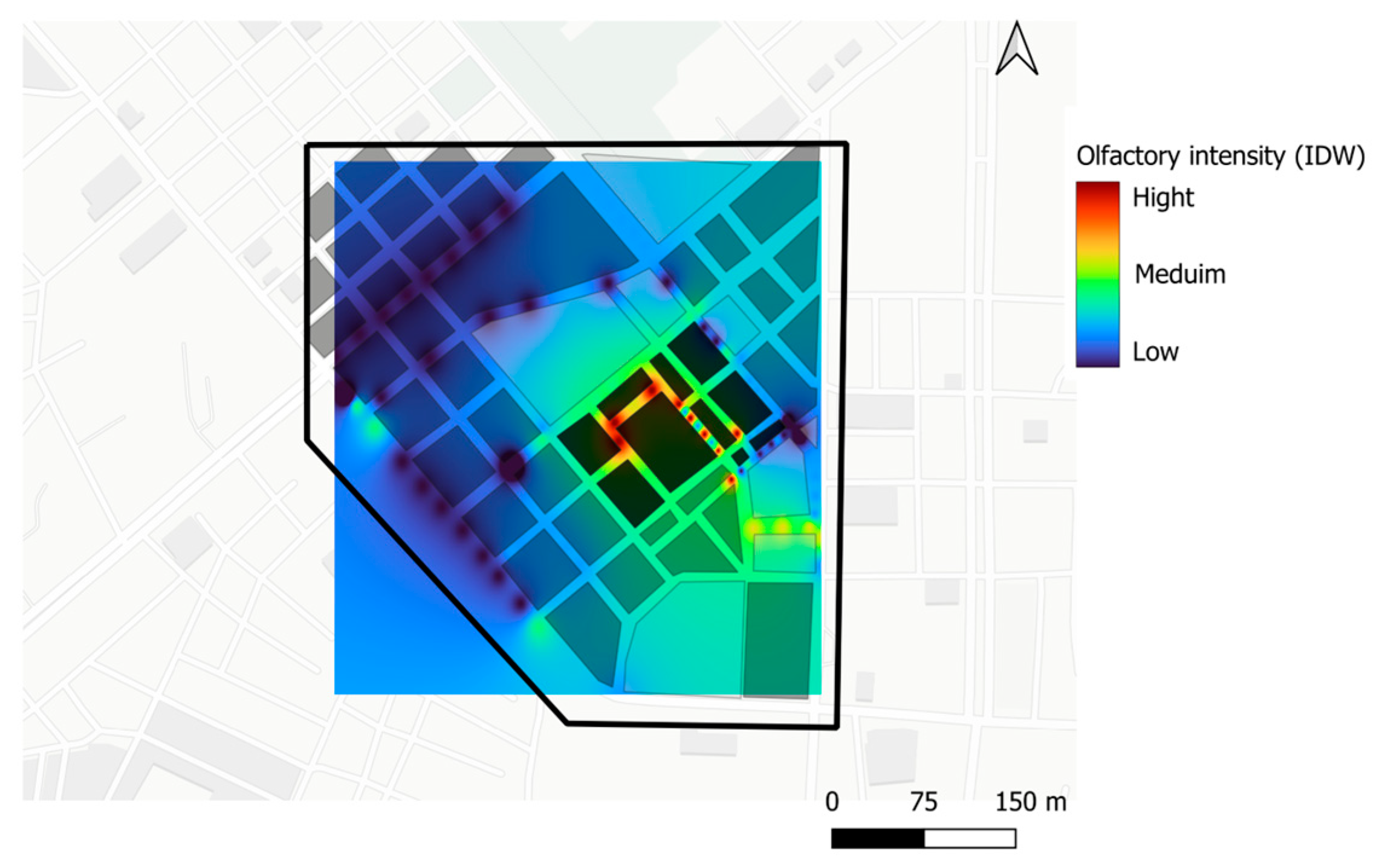
Inverse Distance Weighted (IDW) interpolation of perceived olfactory intensity values derived from georeferenced sensory surveys. The relatively homogeneous surface reflects both the smoothing effect of interpolation techniques applied to perceptual data and the cumulative sensory experience of a dense urban centre, as noted in previous GIS-based perceptual studies [39,44]. Figure 6 supports the exploratory analysis of spatial tendencies rather than precise quantitative measurement and should be interpreted in conjunction with point-based mapping and morphological context.
Figure 6.
Inverse Distance Weighted (IDW) interpolation of olfactory intensity in the city centre of Biskra.
5.3. Exploratory Relationships Between Urban Morphology and Smellscape Patterns
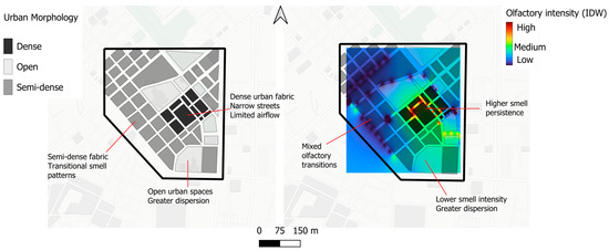
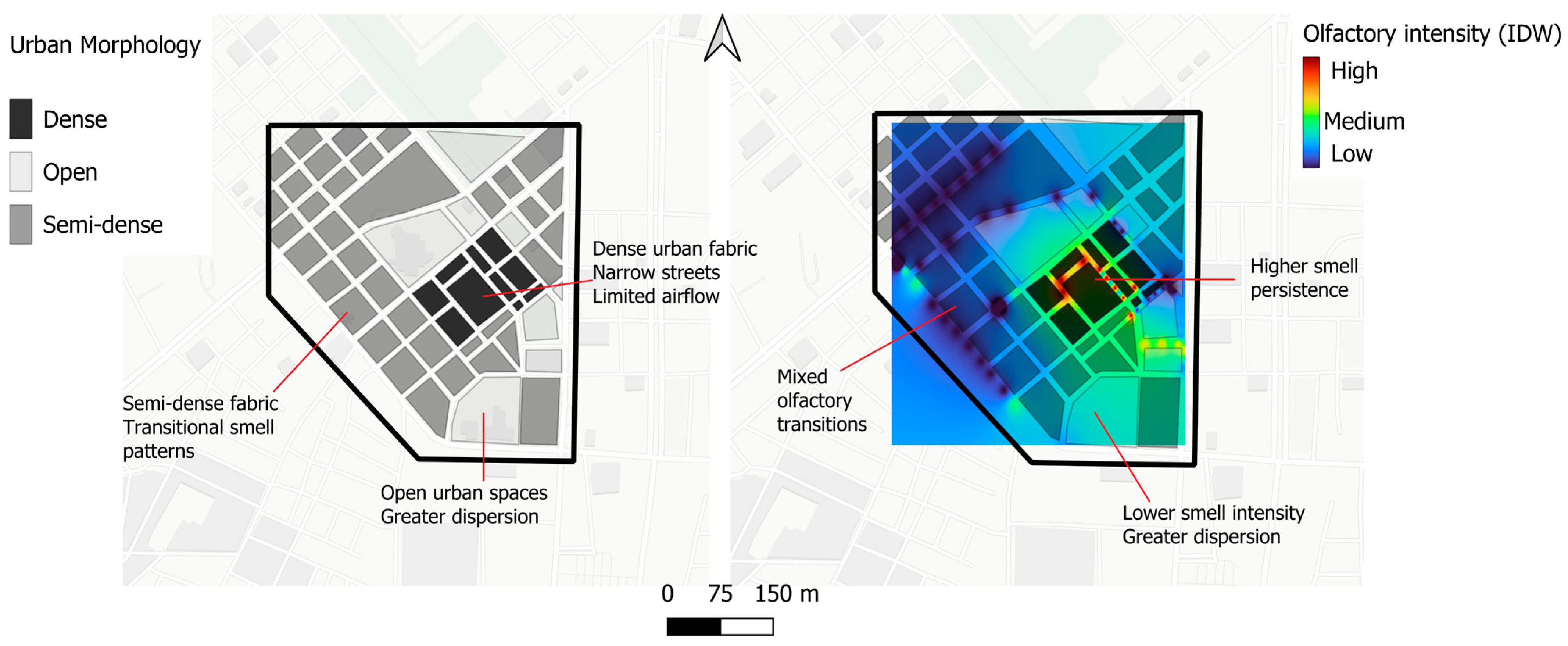
Street width, façade continuity, enclosure ratio, and ground-floor uses were analysed through field observations and urban morphology principles to support the interpretation of smellscape patterns in relation to the built environment [15,31,35]. To strengthen this interpretation, the IDW-interpolated olfactory intensity map was superimposed onto the street morphology map within a GIS environment (Figure 7), following exploratory spatial analysis approaches commonly adopted in environmental perception studies [39].
Figure 7.
Comparative spatial interpretation of urban morphology and IDW-interpolated olfactory intensity patterns in the city centre of Biskra.
This comparative spatial interpretation enabled a visual examination of recurrent olfactory intensity patterns in relation to morphological characteristics at the street scale. By juxtaposing the IDW surface with morphological attributes, it was possible to explore potential spatial associations between perceived olfactory intensity and variations in street enclosure, façade continuity, and ground-floor activity, as suggested by previous research linking built form and sensory experience [26,31].
The overlay was not intended as a quantitative correlation analysis but rather as an exploratory interpretive tool supporting the qualitative understanding of smellscape formation. The comparison suggested that dense and enclosed urban fabrics tended to correspond with stronger olfactory persistence, whereas more open street configurations appeared associated with greater airflow and odour dispersion. These observations are summarised in Table 2.
Table 2.
Exploratory relationships between urban morphology characteristics and observed olfactory patterns in the city centre of Biskra.
The superposition approach provided a morphological context for interpreting GIS-based olfactory outputs and contributed to a more integrated reading of sensory perception and urban form. However, the observed relationships should be understood as exploratory spatial associations rather than deterministic causal relationships, and future studies incorporating advanced spatial–statistical methods could further investigate these interactions [35].
Figure 7 suggests that dense and enclosed urban fabrics tend to correspond with stronger olfactory persistence, whereas open urban configurations appear associated with greater airflow and smell dispersion. This comparative visualisation is intended as an exploratory interpretive tool rather than a deterministic statistical correlation analysis.
6. Discussion
The analysis of olfactory data collected through smellwalking, sensory questionnaires, and GIS-based mapping provides a comprehensive understanding of how urban smellscapes are shaped by the interaction between building morphology, street configuration, and everyday urban functions in the city centre of Biskra. Rather than considering smells as isolated environmental by-products, the findings highlight smellscapes as emergent and spatially structured phenomena embedded in the built environment and daily practices [19,29].
Point-based olfactory mapping reveals clear spatial associations between odour typologies and urban functions. Traditional commercial streets characterised by active ground-floor uses are dominated by food-related, aromatic, tea, fruit, and spice odours, which are generally perceived as pleasant. These smells contribute to a distinctive olfactory identity and reinforce the social and commercial character of these streets, as reported in previous smellscape studies [29,31]. In contrast, traffic- and waste-related odours are mainly concentrated along major roads and infrastructural corridors, where vehicular flow and limited pedestrian-oriented activity prevail. This spatial differentiation suggests that olfactory perception may be associated with functional zoning and street hierarchy.
Building morphology may contribute to these olfactory patterns. Streets with continuous façades, moderate enclosure ratios, and relatively narrow cross-sections appear associated with greater odour persistence generated by ground-floor activities, resulting in recognisable and often positively perceived smellscapes [26,31]. In these environments, smells are not experienced as nuisances but as integral components of everyday urban life. Conversely, fragmented urban forms and wide, traffic-dominated streets promote odour dispersion while simultaneously introducing unpleasant emissions, leading to weak or negatively perceived olfactory environments. These findings support the interpretation of smellscapes as products of both physical form and social use, rather than solely environmental conditions.
The IDW interpolation of perceived olfactory intensity produces a relatively homogeneous surface across the study area. While this outcome might initially be interpreted as a limitation of the method, it may be interpreted as a representation of the cumulative sensory experience of the city centre. From a methodological perspective, interpolation techniques applied to perceptual data inherently smooth local variations and reduce sharp contrasts [39]. From an experiential perspective, the homogeneity may reflect the lived reality of dense urban centres, where multiple odour sources overlap and create a continuous sensory background rather than discrete zones of intensity. This reinforces the importance of interpreting GIS-based outputs in conjunction with qualitative smellwalking observations and morphological analysis [42].
The pleasantness mapping further clarifies the distinction between olfactory intensity and olfactory quality. Areas associated with high or moderate intensity do not necessarily correspond to negative perception. On the contrary, commercial streets with intense food-related odours are often evaluated positively due to their cultural familiarity and social meaning [21,29]. In contrast, traffic-related odours tend to be perceived as unpleasant even when their intensity is relatively low. This suggests that pleasantness may be influenced more strongly by odour type, context, and cultural interpretation than by intensity alone.
Climatic conditions specific to Biskra further shape these dynamics. In an arid environment characterised by high temperatures and limited vegetation, odours may persist and disperse differently than in temperate climates. Urban vegetation and green infrastructure may also play an important role in shaping urban smellscapes. Street trees, small green spaces, and vegetated courtyards can introduce natural odours while contributing to improved environmental perception and more favourable microclimatic conditions in public spaces. In arid urban environments such as Biskra, integrating vegetation into street design could therefore enhance positive sensory experiences while simultaneously supporting environmental quality and urban sustainability. Pleasant smellscapes associated with markets and food-related activities may contribute to positive environmental perception and enhance the sensory attractiveness of public spaces. In contrast, unpleasant odours linked to traffic and waste may negatively affect the perceived quality of the urban environment. These observations further highlight the importance of considering olfactory dimensions within sustainable urban design strategies for arid and semi-arid cities [12,16].
When compared with previous smellscape studies conducted in European and East Asian contexts, the findings show both convergence and divergence. Consistent with earlier research, food-related and aromatic odours play a positive role in reinforcing place identity and social life [29,31]. However, the relatively homogeneous olfactory intensity patterns observed in Biskra contrast with the sharper spatial gradients often reported in temperate cities [43]. This difference may suggest that climatic conditions, urban density, and continuous commercial activity in arid contexts contribute to a more uniform sensory background. By exploring potential associations between olfactory perception, building morphology, and street configuration, this study contributes original empirical evidence from a North African context that remains largely underrepresented in sensory urban studies. The contribution of the study lies primarily in the application of established smellwalking, sensory survey, and GIS-based approaches to an understudied arid urban environment rather than in the development of a new methodological framework.
Overall, the findings suggest that urban smellscapes are not secondary or accidental aspects of the city but constitute an essential dimension of environmental perception shaped by architecture, urban form, and everyday practices [19,29]. Integrating smellscape analysis into building and street design offers new opportunities for enhancing sensory comfort, place identity, and sustainability, particularly in climate-sensitive urban environments.
From an urban design perspective, the findings highlight the importance of street morphology and ground-floor activities in shaping the sensory experience of urban environments. Streets characterised by continuous façades, mixed uses, and active edges appear associated with identifiable and socially meaningful smellscapes, potentially contributing to place identity and pedestrian experience. In contrast, traffic-dominated streets produce weaker or unpleasant olfactory environments, reducing the perceived quality of public space. These results suggest that integrating sensory considerations into street design and urban morphology analysis may enhance the experiential quality of urban environments.
7. Research Limitations and Future Directions
Several limitations should be considered when interpreting the findings of this study. First, olfactory perception is inherently subjective and may vary according to individual sensitivity, personal experiences, cultural background, and environmental conditions. Although the combination of smellwalking and questionnaire-based evaluation improved the robustness of the observations, individual differences in odour perception cannot be entirely eliminated.
Second, the study was based on 30 questionnaire respondents and a single field campaign conducted on 2 February 2026. Consequently, the results represent the sensory conditions observed during the survey period and may not fully capture seasonal or temporal variations in urban smellscapes.
Third, the spatial analysis relied on an Inverse Distance Weighting (IDW) interpolation of perceptual odour intensity ratings. While this approach was useful for visualising recurring spatial tendencies and supporting exploratory interpretation, it should not be considered a deterministic representation of odour dispersion processes. The resulting interpolated surfaces reflect perceived sensory patterns rather than direct environmental measurements. Furthermore, the IDW interpolation was employed primarily as an exploratory visualisation tool within the QGIS environment, and the emphasis of the analysis was placed on the interpretation of spatial tendencies rather than on the optimisation of interpolation parameters. Consequently, the results should be understood as indicative spatial representations of perceptual tendencies rather than precise models of odour dispersion.
Finally, the relationship between urban morphology and smellscape patterns identified in this study should be understood as an exploratory spatial association rather than a causal relationship. Future research could expand this work through larger participant samples, seasonal observations, microclimatic measurements, and advanced spatial-statistical analyses to further investigate the interactions between urban form, environmental conditions, and olfactory perception in arid urban environments.
8. Conclusions
This study highlights the value of integrating olfactory perception into the analysis of street morphology and urban spatial configuration. By combining smellwalking, sensory questionnaires involving 30 participants, and GIS-based spatial mapping of 80 georeferenced observation points, the research explored how urban smellscapes emerge through the interaction between built form, urban activities, and everyday social practices in the city centre of Biskra.
The findings suggest that streets characterised by continuous façades, moderate enclosure ratios, and active ground-floor uses tend to be associated with identifiable and often positively perceived olfactory environments, frequently linked to food-related and aromatic smells. Conversely, streets dominated by vehicular traffic appear more likely to be associated with unpleasant olfactory perceptions that may affect the perceived quality of the urban environment.
The GIS-based mapping and IDW interpolation of perceived olfactory intensity revealed relatively homogeneous spatial patterns across the study area. These patterns may reflect both the smoothing effect inherent to interpolation techniques and the cumulative sensory character of dense urban environments. The results also highlight the importance of combining GIS-based spatial analysis with qualitative sensory observations to support the interpretation of urban smellscapes.
Beyond its methodological contribution, this study demonstrates the potential of smellscape analysis as a complementary approach for investigating environmental perception and sensory experience in urban environments. The comparative interpretation of smellscape patterns and urban morphology suggests potential associations between street configuration, building form, and olfactory perception, while acknowledging that these relationships remain exploratory and require further investigation.
In arid urban contexts such as Biskra, where climatic conditions may influence environmental perception and outdoor comfort, integrating sensory considerations into urban design could contribute to more liveable, resilient, and sustainable street environments. Smellmapping therefore represents a promising complementary tool for architects, planners, and urban designers seeking to develop more human-centred urban spaces.
Future research may further investigate the relationships between urban morphology and smellscape patterns through larger datasets, seasonal observations, and advanced spatial analytical approaches, particularly in arid urban environments.
Supplementary Materials
The following supporting information can be downloaded at: https://www.mdpi.com/article/10.3390/architecture6030097/s1, Supplementary Material S1: Sensory Questionnaire Used for Smellscape Assessment.
Author Contributions
Conceptualisation, L.B., F.Z.L. and K.M.; methodology, L.B.; software, L.B.; validation, L.B., F.Z.L. and K.M.; formal analysis, L.B.; investigation, L.B.; resources, L.B. and F.Z.L.; data curation, L.B.; writing—original draft preparation, L.B.; writing—review and editing, F.Z.L. and K.M.; visualisation, L.B.; supervision, K.M.; project administration, L.B. All authors have read and agreed to the published version of the manuscript.
Funding
This research received no external funding.
Institutional Review Board Statement
According to Algerian legislation on personal data protection (Law No. 18-07 of 10 June 2018), personal data is defined as information relating to an identified or identifiable individual. As the study is a non-interventional observational investigation conducted in public spaces and does not involve the collection of sensitive or identifiable personal data, formal approval from an Institutional Review Board or Ethics Committee was not required.
Informed Consent Statement
Informed consent was obtained from all participants involved in the study. Participants were informed about the objectives of the research, the voluntary nature of their participation, and the anonymous treatment of the collected data. No personally identifiable information was recorded.
Data Availability Statement
The original contributions presented in this study are included in the article. Further enquiries can be directed to the corresponding author.
Conflicts of Interest
The authors declare no conflicts of interest.
Abbreviations
The following abbreviations are used in this manuscript:
| GIS | Geographic Information Systems |
| IDW | Inverse Distance Weighting |
References
- Lynch, K. “The Image of the Environment” and “The City Image and Its Elements”: From The Image of the City (1960). In The Urban Design Reader; Routledge: London, UK, 2013; pp. 125–138. [Google Scholar]
- Jacobs, J. The Death and Life of Great American Cities; Random House: New York, NY, USA, 1961. [Google Scholar]
- Tuan, Y.-F. Space and Place: The Perspective of Experience; University of Minnesota: Minneapolis, MN, USA, 1977. [Google Scholar]
- Relph, E. Place and Placelessness; Pion: London, UK, 1976; Volume 67. [Google Scholar]
- Lefebvre, H. The production of space (1991). In The People, Place, and Space Reader; Routledge: London, UK, 2014; pp. 289–293. [Google Scholar]
- Steele, F. The Sense of Place; CBI: Boston, MA, USA, 1981. [Google Scholar]
- Southworth, M.F. The Sonic Environment of Cities; Massachusetts Institute of Technology: Cambridge, MA, USA, 1967. [Google Scholar]
- Kang, J.; Aletta, F. The impact and outreach of soundscape research. Environments 2018, 5, 58. [Google Scholar] [CrossRef] [Scilit]
- Kang, J.; Schulte-Fortkamp, B. Soundscape and the Built Environment; CRC Press: Boca Raton, FL, USA, 2016; Volume 525. [Google Scholar]
- ISO 12913-1:2014; Acoustics—Soundscape—Part 1: Definition and Conceptual Framework. International Organization for Standardization (ISO): Geneva, Switzerland, 2014.
- Yang, W.; Kang, J. Acoustic comfort evaluation in urban open public spaces. Appl. Acoust. 2005, 66, 211–229. [Google Scholar] [CrossRef] [Scilit]
- Carmona, M. Place value: Place quality and its impact on health, social, economic and environmental outcomes. J. Urban Des. 2019, 24, 1–48. [Google Scholar] [CrossRef] [Scilit]
- Aelbrecht, P.; Arefi, M.; Araabi, H.F. New emerging urban design tools. Urban Des. Int. 2025, 30, 1–2. [Google Scholar] [CrossRef] [Scilit]
- Abbassy, N.; El-Husseiny, M.; Shaker, S. Smell-waking as a cognitive mapping tool: Investigating the smellscape of Syrian food for placemaking in Cairo’s outskirts. Urban Des. Int. 2025, 30, 3–20. [Google Scholar] [CrossRef] [Scilit]
- Stojanovski, T.; Östen, A. Typo-morphology and environmental perception of urban space. In Proceedings of the XXV ISUF International Conference “Urban Form and Social Context: From Traditions to Newest Demands”, Krasnoyarsk, Russia, 5–9 July 2018. [Google Scholar]
- UN-HABITAT. World Cities Report 2024: Cities and Climate Action; Stylus Publishing, LLC: Sterling, VA, USA, 2024. [Google Scholar]
- Bibri, S.E.; Krogstie, J. Smart sustainable cities of the future: An extensive interdisciplinary literature review. Sustain. Cities Soc. 2017, 31, 183–212. [Google Scholar] [CrossRef] [Scilit]
- Sharifi, A. Urban sustainability assessment: An overview and bibliometric analysis. Ecol. Indic. 2021, 121, 107102. [Google Scholar] [CrossRef] [Scilit]
- Porteous, J.D. Smellscape. Prog. Phys. Geogr. 1985, 9, 356–378. [Google Scholar] [CrossRef] [Scilit]
- Spence, C. Senses of place: Architectural design for the multisensory mind. Cogn. Res. Princ. Implic. 2020, 5, 46. [Google Scholar] [CrossRef] [Scilit] [PubMed]
- Herz, R. The Scent of Desire: Discovering Our Enigmatic Sense of Smell; HarperCollins: New Yourk, NY, USA, 2007. [Google Scholar]
- Stevenson, R.J. An initial evaluation of the functions of human olfaction. Chem. Senses 2010, 35, 3–20. [Google Scholar] [PubMed]
- Majid, A.; Burenhult, N. Odors are expressible in language, as long as you speak the right language. Cognition 2014, 130, 266–270. [Google Scholar] [CrossRef] [Scilit] [PubMed]
- Cabanac, M. Sensory pleasure. Q. Rev. Biol. 1979, 54, 1–29. [Google Scholar] [CrossRef] [Scilit] [PubMed]
- Pallasmaa, J. Hapticity and time. Archit. Rev. 2000, 207, 78–84. [Google Scholar]
- Pallasmaa, J. The Eyes of the Skin: Architecture and the Senses; John Wiley & Sons: Hoboken, NJ, USA, 2024. [Google Scholar]
- Theodore, D. Sense of the City: An Alternative Approach to Urbanism-Edited by Mirko Zardini 2006. J. Archit. Educ. 2006, 60, 69–70. [Google Scholar] [CrossRef] [Scilit]
- Kahn, P.H. Technological Nature: Adaptation and the Future of Human Life; MIT Press: Cambridge, MA, USA, 2011. [Google Scholar]
- Henshaw, V. Urban Smellscapes: Understanding and Designing City Smell Environments; Routledge: London, UK, 2013. [Google Scholar]
- Amphoux, P. Ambiance Architecturale et Urbaine. In Dictionnaire de la Géographie; Lévy, J., Lussault, M., Eds.; Belin: Paris, France, 2013; pp. 72–73. [Google Scholar]
- He, J.; Hao, Z.; Li, L.; Ye, T.; Sun, B.; Wu, R.; Pei, N. Sniff the urban park: Unveiling odor features and landscape effect on smellscape in Guangzhou, China. Urban. For. Urban. Green. 2022, 78, 127764. [Google Scholar] [CrossRef] [Scilit]
- Classen, C.; Howes, D.; Synnott, A. Aroma: The cultural History of Smell; Routledge: London, UK, 2002. [Google Scholar]
- Han, T.; Tang, L.; Liu, J.; Jiang, S.; Yan, J. The influence of multi-sensory perception on public activity in urban street spaces: An empirical study grounded in landsenses ecology. Land 2024, 14, 50. [Google Scholar] [CrossRef] [Scilit]
- Lu, X.; Li, Q.; Ji, X.; Sun, D.; Meng, Y.; Yu, Y.; Lyu, M. Impact of streetscape built environment characteristics on human perceptions using street view imagery and deep learning: A case study of Changbai Island, Shenyang. Buildings 2025, 15, 1524. [Google Scholar] [CrossRef] [Scilit]
- Marshall, S. Streets and Patterns; Routledge: London, UK, 2004. [Google Scholar]
- WHO. Environmental Noise Guidelines for the European Region 2018; WHO: Copenhagen, Denmark, 2018. [Google Scholar]
- Wojnarowska, M.; Sagan, A.; Plichta, J.; Plichta, G.; Szakiel, J.; Turek, P.; Sołtysik, M. The influence of the methods of measuring odours nuisance on the quality of life. Environ. Impact Assess. Rev. 2021, 86, 106491. [Google Scholar] [CrossRef] [Scilit]
- Spennemann, D.H.R.; Parker, M.; Bond, J. Attenuation of odours in the urban outdoor environment: A rapid review and implications for the conduct and interpretation of smell walks. Environments 2023, 10, 163. [Google Scholar] [CrossRef] [Scilit]
- Palacio Buendia, A.V.; Pérez-Albert, Y.; Serrano Gine, D. Mapping landscape perception: An assessment with public participation geographic information systems and spatial analysis techniques. Land 2021, 10, 632. [Google Scholar] [CrossRef] [Scilit]
- Thibaud, J.-P. The sensory fabric of urban ambiances. Senses Soc. 2011, 6, 203–215. [Google Scholar] [CrossRef] [Scilit]
- McLean, K.J. Nose-First: Practices of Smellwalking and Smellscape Mapping; Royal College of Art: London, UK, 2019. [Google Scholar]
- Quercia, D.; Schifanella, R.; Aiello, L.M.; McLean, K. Smelly maps: The digital life of urban smellscapes. In Proceedings of the International AAAI conference on Web and Social Media, Oxford, UK, 26–29 May 2015; Volume 9, pp. 327–336. [Google Scholar]
- Gao, Y.-J.; Wang, C.-L.; Huang, M.-L.; Guo, W. A new perspective of sustainable perception: Research on the smellscape of urban block space. Sustainability 2022, 14, 9184. [Google Scholar] [CrossRef] [Scilit]
- Yang, W.; Zhao, Y.; Wang, D.; Wu, H.; Lin, A.; He, L. Using principal components analysis and IDW interpolation to determine spatial and temporal changes of surface water quality of Xin’anjiang river in Huangshan, China. Int. J. Environ. Res. Public Health 2020, 17, 2942. [Google Scholar] [CrossRef] [Scilit] [PubMed]
- Lai, P.; Ou, D. Multisensory interaction: Exploring the effects of soundscape, landscape, and smellscape on individual comforts and behavioral intentions in urban park. Energy Build. 2025, 353, 116885. [Google Scholar] [CrossRef] [Scilit]
- Gehl, J. Life Between Buildings: Using Public Space; Princeton University Press: New Jersey, NJ, USA, 2012. [Google Scholar]
- Gehl, J.; Svarre, B. How to Study Public Life; Island Press: Washington, DC, USA, 2013; Volume 2. [Google Scholar]
- Batty, M. The New Science of Cities; MIT Press: Cambridge, MA, USA, 2013. [Google Scholar]
- Nasar, J.L.; Fisher, B. ‘Hot spots’ of fear and crime: A multi-method investigation. J. Environ. Psychol. 1993, 13, 187–206. [Google Scholar] [CrossRef] [Scilit]
- McLean, K. Smellmap: Amsterdam—Olfactory art and smell visualization. Leonardo 2017, 50, 92–93. [Google Scholar] [CrossRef] [Scilit]
- Ryden, K.C. Mapping the Invisible Landscape: Folklore, Writing, and the Sense of Place; University of Iowa Press: Iowa City, IA, USA, 1993. [Google Scholar]
- Côte, M. L’algerie Espace er Societe Masson; Masson/Armand Colin: Malakoff Cedex, France, 1996. [Google Scholar]
- Çelik, Z.; McDermott, J. Urban forms & colonial confrontations: Algiers under French rule. Urban Hist. Rev. 1997, 26, 59. [Google Scholar]
- Wright, G. The Politics of Design in French Colonial Urbanism; University of Chicago Press: Chicago, IL, USA, 1991. [Google Scholar]
- King, A.D. Colonial Urban Development: Culture, Social Power and Environment; Routledge: London, UK, 2012. [Google Scholar]
- Bianca, S. Urban form in the Arab world: Past and Present; Vdf Hochschulverlag AG: Geneva, Switzerland, 2000; Volume 46. [Google Scholar]
- Rapoport, A. Theory, culture and housing. Hous. Theory Soc. 2000, 17, 145–165. [Google Scholar] [CrossRef] [Scilit]

Disclaimer/Publisher’s Note: The statements, opinions and data contained in all publications are solely those of the individual author(s) and contributor(s) and not of MDPI and/or the editor(s). MDPI and/or the editor(s) disclaim responsibility for any injury to people or property resulting from any ideas, methods, instructions or products referred to in the content. |
© 2026 by the authors. Licensee MDPI, Basel, Switzerland. This article is an open access article distributed under the terms and conditions of the Creative Commons Attribution (CC BY) license.