


Abstract
Historic urban districts are increasingly exposed to rapid urban transformation, resulting in the deterioration of heritage fabric, weakening of spatial identity, and disruption of everyday patterns of use. Although participatory approaches are increasingly recognised in heritage-led regeneration, many applications remain limited by the lack of analytical mechanisms capable of connecting community perspectives with spatial and behavioural evidence in a structured and practical manner. This study develops and applies a participatory decision-support approach based on the People–Place–Behaviour (PPB) framework within the historic district of El-Mokhtalat in Mansoura, Egypt. The study combines spatial documentation, behavioural observation, and stakeholder consultation to examine how everyday urban practices, adaptive reuse, informal interventions, and local perceptions collectively influence regeneration priorities within the historic environment. The findings indicate that regeneration priorities emerge through the interaction between spatial conditions, community perceptions, and behavioural patterns rather than through isolated physical conditions alone. Based on stakeholder consultations (n = 30), the analysis identifies a prioritisation gradient in which architectural conservation and environmental enhancement represent the most immediate intervention priorities, while adaptive reuse and public-space improvements remain dependent on contextual compatibility and local acceptance. The study also demonstrates the analytical value of behavioural evidence in revealing recurring spatial pressures, identity-related transformations, and everyday interaction patterns affecting the continuity of the historic urban fabric. By integrating participatory, spatial, and behavioural evidence within a unified evaluation process, the study proposes a context-sensitive analytical approach capable of supporting more informed and locally responsive heritage-led regeneration strategies.
1. Introduction
Historic urban districts represent essential components of urban identity and cultural continuity, reflecting accumulated architectural layers and collective memory embedded within evolving urban systems [1]. By preserving historical spatial structures and cultural landscapes, these districts also contribute to socio-spatial resilience and reinforce the relationship between cultural identity and the built environment [2,3]. Nevertheless, many historic districts are increasingly threatened by rapid urban transformation, unregulated development, and the gradual deterioration of heritage fabric, often exacerbated by the limited integration of heritage values within contemporary urban planning frameworks [4].
In Egypt, these pressures are further intensified by fragmented governance structures and centralised planning practices that limit effective community participation in urban decision-making processes [5]. Consequently, historically significant urban fabrics frequently experience progressive deterioration despite their architectural, cultural, and socio-economic importance [6]. These challenges highlight the need for planning approaches capable of linking heritage conservation with inclusive and context-sensitive urban regeneration.
Recent research increasingly emphasises participatory approaches as mechanisms for aligning regeneration strategies with community needs and local knowledge systems [7]. Participatory documentation and stakeholder engagement are therefore recognised as important tools for generating context-specific knowledge capable of informing regeneration processes in historic urban districts [8]. Field-based documentation methods can further support this process by identifying spatial conditions, heritage characteristics, and locally perceived development priorities within historic urban environments [9].
In historic urban environments, behavioural patterns are not limited to movement dynamics but also include everyday interactions with heritage spaces, adaptive reuse practices, informal façade modifications, and community responses to changing urban conditions. These interactions influence both the continuity of architectural identity and the lived experience of the historic urban fabric.
Although participatory approaches are increasingly recognised in heritage planning, their application often remains limited to consultative and qualitative practices, with insufficient translation into structured decision-support mechanisms. This highlights the absence of operational frameworks capable of systematically integrating participatory inputs with spatial and behavioural analysis to inform regeneration decisions.
Within this context, the historic district of El-Mokhtalat in Mansoura provides a relevant empirical setting for examining how participatory regeneration approaches can be operationalised in practice. The district represents a historically significant residential quarter characterised by distinctive architectural heritage and urban identity, while simultaneously experiencing pressures of urban transformation, insufficient maintenance practices, and fragmented governance affecting heritage conservation efforts.
This study aims to develop and operationalise a participatory decision-support framework for heritage-led urban regeneration that integrates participatory, spatial, and behavioural data within a unified analytical structure, enabling the systematic identification and prioritisation of context-sensitive regeneration interventions.
Accordingly, the study addresses the following research questions:
- Q1. How can participatory documentation and field observation support the development of structured analytical tools for urban heritage regeneration?
- Q2. How can participatory evidence contribute to identifying regeneration priorities that balance heritage preservation, adaptive reuse, and community needs?
- Q3. How effective is the proposed participatory framework in evaluating regeneration feasibility and supporting informed planning decisions in historic urban districts?
The analytical workflow follows a structured process integrating data collection, analysis, and evaluation through the PPB framework, as presented in Figure 1.
Figure 1.
Methodological framework illustrating the integration of participatory knowledge and documentation within the People–Place–Behaviour (PPB) analytical framework, translated through an evaluation matrix to generate decision-support strategies for heritage-led urban regeneration. The arrows indicate the sequential flow from participatory inputs and documentation to PPB analysis, evaluation, decision-support strategies, and heritage-led urban regeneration. The colours distinguish the three PPB dimensions and the successive analytical and strategic stages of the framework.
2. Literature Review
2.1. Participatory Urban Planning
Participatory urban planning is a collaborative approach that actively involves citizens and stakeholders in shaping policies, projects, and spaces that affect their lives [10]. Unlike top-down planning, it integrates local knowledge and values into the development process, resulting in more contextually appropriate and widely accepted solutions [8]. However, participation is not a uniform process and varies in both depth and influence. Arnstein [11] conceptualised participation as a hierarchical ladder ranging from non-participation to full citizen control, distinguishing between tokenistic involvement and genuine empowerment. Building on this foundation, contemporary participatory planning theory emphasises collaborative dialogue and knowledge co-production as alternatives to one-way consultation [12]. Addressing these challenges requires structured stakeholder engagement processes that integrate diverse perspectives into decision-making [13].
The core principles of participatory planning encompass stakeholder diversity, community empowerment in decision-making, co-production of knowledge through dialogue, and adaptability to local cultural and environmental contexts [14]. These principles form the conceptual basis of the study and situate participatory planning within the “People” dimension of the People–Place–Behaviour (PPB) analytical framework, highlighting the role of stakeholder engagement in shaping inclusive and context-sensitive planning processes. Within this perspective, participatory planning provides the mechanisms through which community knowledge and stakeholder priorities can be incorporated into regeneration decision-making processes.
Studies have shown the effectiveness of participatory approaches in addressing complex urban issues such as housing, infrastructure, and heritage conservation. For instance, participatory initiatives in several cities have demonstrated how community knowledge can contribute to addressing urban decline and supporting locally grounded regeneration strategies [10]. However, while participatory processes have proven beneficial, they are not a cure-all; persistent challenges such as power imbalances, tokenism, and representation gaps often constrain their transformative potential [7].
In summary, participatory planning is increasingly recognised as crucial for sustainable urban development in the 21st century. It aligns planning practices with democratic governance and ensures that development interventions, including those in heritage areas, are socially inclusive, culturally sensitive, and supported by the people they impact.
2.2. Theoretical Foundations of Heritage, Spatial Identity, and Behaviour in Urban Regeneration
Heritage preservation extends beyond the physical conservation of buildings and urban fabric to include the protection and reinforcement of cultural identity [4,15]. This perspective is grounded in established international conservation frameworks, particularly the Venice Charter [16], which emphasises the protection of material authenticity, and the Burra Charter [17], which extends this approach by recognising cultural significance and community values as central to heritage conservation and management. Within this perspective, heritage-led urban regeneration is not understood as a passive act of safeguarding the physical legacy, but as an active process in which heritage functions as a cultural, spatial, and social resource guiding urban revitalisation and place-making processes [1,18].
Urban heritage can be understood as a dynamic system linking inherited values with future-oriented development, where everyday practices contribute to sustaining cultural meaning and reinforcing place attachment [2,19]. Within this perspective, adaptive reuse functions as a key mechanism for reactivating heritage assets through contextually relevant uses while preserving their defining characteristics.
Spatial identity reflects the meanings and experiential attachments through which users relate to place, drawing on place theory [20,21]. This highlights the interdependence between spatial form, cultural meaning, and lived experience in shaping historic environments.
Accordingly, everyday practices such as informal alterations or unregulated activities should be interpreted as responses to broader socio-economic and institutional conditions rather than isolated negative behaviours [5,6]. This perspective supports more inclusive conservation approaches, where participatory planning aligns community needs with conservation objectives and strengthens shared stewardship [3,22].
Nevertheless, heritage districts remain vulnerable to unregulated development and weak integration of heritage values within planning frameworks [15,23]. Conventional approaches often prioritise technical restoration over social and behavioural dynamics, overlooking behaviour-driven identity transformation [19,24]. Integrating behavioural insights within participatory frameworks can therefore support more resilient socio-cultural systems [25].
These relationships form the conceptual basis through which the People–Place–Behaviour framework interprets heritage regeneration as an interaction between social perception, spatial conditions, and everyday practices.
2.3. International Models of Community Participation in Heritage Conservation
International experiences increasingly highlight the capacity of participatory approaches to improve both the technical effectiveness of heritage interventions and the social legitimacy of conservation processes. For instance, in Vietnam, citizen engagement has contributed to improving restoration practices while reinforcing the intergenerational transmission of cultural values [3]. Similarly, studies indicate that locally embedded practices and everyday interactions can sustain architectural authenticity and cultural identity, positioning communities as active agents in the conservation process rather than passive beneficiaries [2,26].
In other contexts, such as Palestine, heritage initiatives that integrate community participation across all stages, including planning, implementation, and monitoring, have demonstrated greater durability and social acceptance compared to approaches limited to consultative engagement [27]. These experiences highlight the importance of continuous and embedded participation in reinforcing the relationship between users, spatial context, and everyday practices, thereby contributing to the resilience of heritage environments.
Beyond project-level interventions, UNESCO’s World Heritage Young Professionals Fora highlight the role of youth engagement, knowledge exchange, and capacity building in strengthening heritage awareness and participation. At the same time, the growing integration of digital technologies and participatory documentation practices has expanded opportunities for heritage recording, communication, and public engagement, supporting more inclusive approaches to heritage conservation and management [28,29]. These approaches extend participation beyond formal planning processes, embedding it within broader cultural and educational frameworks.
Collectively, these international models indicate that while participatory approaches significantly enhance conservation outcomes, their implementation often remains fragmented and context-dependent. In many cases, participation is not systematically integrated with spatial analysis or behavioural understanding, limiting its capacity to inform structured decision-making processes. This reveals a critical limitation in existing approaches, namely, the absence of operational frameworks capable of linking participatory inputs with spatial and behavioural dimensions within a unified analytical structure. Addressing this limitation is essential for advancing more effective and context-responsive heritage-led regeneration strategies.
2.4. Heritage Protection and Community Participation in Egypt
In Egypt, heritage conservation is supported by a multi-layered institutional and legal framework that distinguishes between officially registered monuments, buildings of distinctive architectural value, and historically significant urban areas requiring heritage-sensitive management. A key national body in this regard is the National Organization for Urban Harmony (NOUH), a governmental organisation affiliated with the Ministry of Culture. NOUH is concerned with safeguarding Egypt’s architectural and urban character, preparing urban harmony guidelines, and supporting the identification and protection of buildings and areas of distinctive architectural and urban value. Through its official laws and regulations page, NOUH provides access to key legal documents relevant to heritage protection and urban harmony, including Law No. 144 of 2006 and Law No. 119 of 2008 [30].
However, historical or architectural significance does not automatically guarantee enforceable protection unless a building is formally listed, registered, or included within an officially approved protection inventory. This distinction is important for understanding the vulnerability of heritage buildings in historic urban districts such as El-Mokhtalat, where some buildings may possess clear architectural and historical value while remaining exposed to alteration, neglect, or demolition if recognition is not translated into effective statutory protection. Accordingly, heritage-led regeneration in such contexts requires not only architectural documentation and community awareness, but also operational tools capable of linking heritage value, local priorities, behavioural evidence, and institutional decision-making.
Within this institutional context, community involvement has increasingly been recognised as an important factor influencing the effectiveness and sustainability of heritage conservation initiatives in Egypt. In Dahshur (Giza), a heritage tourism development plan was implemented that focused not only on-site preservation but also on providing training and employment opportunities for residents in crafts and tourism activities [5]. This approach improved local livelihoods while fostering a shared sense of responsibility for heritage management. Similarly, in the historic town of Fuwah in Kafr El-Sheikh Governorate, the engagement of artisans and local stakeholders in revitalisation initiatives enabled the adaptive reuse of historic structures and stimulated economic development through the promotion of traditional crafts [31]. Comparable heritage initiatives across Egypt demonstrate varying degrees of community participation and their measurable impact on conservation outcomes. However, in Port Said, the historic urban fabric has experienced deterioration partly due to limited public involvement in conservation processes. In many cases, residents feel disconnected from top-down conservation policies, which have contributed to neglect and unauthorised alterations to historic buildings [32]. Collectively, these cases demonstrate that meaningful community engagement contributes to more sustainable conservation outcomes and strengthens local stewardship of heritage assets, whereas exclusion from decision-making processes often results in neglect or unsustainable interventions. These observations highlight the importance of structured participatory mechanisms capable of translating community engagement into operational planning tools for regeneration [33].
2.5. Synthesis and Research Gap
While the existing literature has addressed participatory planning, heritage conservation, and everyday spatial practices, these domains are still largely examined as separate analytical trajectories. Participatory research primarily focuses on stakeholder engagement and governance processes [7], whereas heritage studies continue to emphasise the material conservation of urban fabric and physical heritage assets [19,24]. Behavioural approaches, in turn, investigate patterns of spatial use and social interaction, often without direct integration into conservation or planning processes. This disciplinary separation limits the capacity of existing approaches to capture the interrelated social, spatial, and behavioural dynamics shaping historic urban environments.
Recent studies have introduced multicriteria and decision-support approaches for heritage regeneration and adaptive reuse [34,35], as well as participatory evaluation models that incorporate stakeholder perspectives into adaptive reuse strategies [36]. However, these approaches rarely integrate participatory input, spatial analysis, and behavioural evidence within a coherent analytical process. Consequently, the translation of diverse qualitative evidence into practical regeneration priorities remains limited.
This limitation is particularly evident in relation to the UNESCO Historic Urban Landscape (HUL) approach, which conceptually advocates the integration of social, cultural, and spatial values [37], yet offers limited methodological guidance for incorporating these interconnected dimensions into regeneration decision-making processes [38].
Rather than functioning as a universal urban model, the proposed PPB approach is applied within lived heritage environments shaped by spatial continuity, architectural identity, and everyday behavioural interaction.
To address this gap, the study develops a participatory decision-support approach based on the People–Place–Behaviour (PPB) framework. The proposed approach brings participatory knowledge, spatial documentation, and behavioural observations together within an integrated evaluation process supporting the identification of context-sensitive regeneration priorities in historic urban districts.
The contribution of this study, therefore, does not lie in presenting People, Place, and Behaviour as entirely new conceptual categories, but in structuring their interaction within a qualitative decision-support matrix for regeneration prioritisation in a lived historic district.
3. Conceptual and Analytical Framework
This study examines historic urban environments as lived settings shaped through the interaction between people, place, and everyday behaviour. Drawing on the UNESCO Historic Urban Landscape (HUL) approach [37], heritage is understood not only as a physical and cultural resource, but also as a lived urban environment influenced by everyday practices, spatial continuity, and ongoing urban change. Within this perspective, local communities contribute to shaping heritage value and spatial identity through their everyday interaction with the historic environment.
Accordingly, the study is organised around three interconnected dimensions: People, Place, and Behaviour. The People dimension addresses users’ perceptions, needs, and lived experiences associated with the historic setting. The Place dimension focuses on the spatial and physical characteristics of the heritage fabric, including urban condition, architectural vocabulary, historic continuity, and place image. The Behaviour dimension examines patterns of use, adaptive reuse practices, informal interventions, façade modifications, and modes of spatial occupation influencing the continuity and transformation of the historic district.
Relationships between these dimensions were examined through field observations, spatial documentation, behavioural interpretation, and stakeholder consultation. Table 1 outlines the analytical dimensions and interpretive criteria that inform the evaluation process used later in the study.
Table 1.
Analytical dimensions, evaluation criteria, and operational indicators operationalising the People–Place–Behaviour (PPB) analytical framework.
4. Methodology
This study adopts an exploratory qualitative approach combining community consultation, spatial documentation, and behavioural observation to examine heritage-led regeneration conditions within El-Mokhtalat historic district in Mansoura. The district was selected as the case study due to its architectural significance and the ongoing spatial and social transformations affecting its historic urban fabric.
The analysis was organised around the People–Place–Behaviour (PPB) dimensions. The People dimension was explored through structured interviews and consultation discussions with local residents, shop owners, property users, and local representatives to examine perceptions of heritage value, regeneration priorities, and ongoing urban change. The Place dimension focused on documenting the spatial and physical characteristics of the district, including heritage buildings, façades, urban condition, visual relationships, and the physical state of historically significant spaces. The Behaviour dimension examined everyday patterns of use and interaction within the historic environment, including movement concentration, adaptive reuse practices, informal interventions, façade modifications, and recurring patterns of spatial occupation.
Spatial observations, stakeholder consultations, and behavioural findings were comparatively reviewed to support the interpretation of regeneration priorities within the study area. To strengthen contextual interpretation and observational consistency, field investigations were conducted through approximately eight repeated site visits distributed over one year under different temporal conditions, including weekdays, weekends, and morning and evening periods. These repeated visits helped identify recurring behavioural patterns, adaptive spatial practices, and changing forms of interaction within the historic urban environment.
Field observations focused on recurring movement patterns, activity concentration, adaptive reuse practices, and informal interventions affecting the continuity and visual coherence of the historic urban fabric. Observed conditions were reviewed through spatial mapping, photographic documentation, and stakeholder consultation to compare recurring spatial and behavioural patterns across different parts of the district.
The analytical process followed a sequential structure linking documentation, interpretation, and evaluation. Observational findings and consultation inputs were interpreted together to identify recurring spatial and behavioural conditions influencing regeneration priorities within the district. Particular attention was given to movement concentration, informal façade modifications, adaptive reuse practices, behavioural interaction with the urban environment, and locally expressed regeneration concerns. These observations informed the evaluation criteria and regeneration directions discussed later in the study.
To further clarify the methodological alignment between the PPB framework and the fieldwork process, the fieldwork was structured around three complementary evidence streams: stakeholder consultation for the People dimension, spatial and architectural documentation for the Place dimension, and structured behavioural observation supported by spatial–behavioural mapping for the Behaviour dimension. The thematic organisation and PPB-based coding of consultation inputs are further detailed in Section 4.2 where the procedure used to translate stakeholder responses into PPB-coded evidence for the evaluation matrix is explained.
Table 2 summarises the relationship between the three PPB framework dimensions, their analytical focus, and the corresponding data collection methods used in the study.
Table 2.
Relationship between PPB Framework Dimensions and Data Collection Methods.
4.1. Site Analysis and Behavioural Observation
Fieldwork was conducted across multiple site visits to document spatial conditions and everyday practices within the El-Mokhtalat district. In this study, behavioural observation refers to the qualitative documentation of visible use-related transformations and everyday spatial practices affecting the built environment. The analysis examined how daily use, functional adaptation, informal modifications, movement concentration, and occupation practices were reflected in the physical and visual condition of streets, façades, building interfaces, and public spaces.
The fieldwork followed a structured, qualitative, and non-participant approach through approximately eight repeated site visits distributed over one year. The visits were intentionally distributed across weekdays, weekends, morning periods, and evening periods in order to capture variations in everyday use, movement intensity, institutional activity, commercial operation, and public-space occupation under different temporal conditions. Each visit generally lasted between two and four hours, depending on site conditions and the extent of photographic and spatial documentation required, and was guided by a common observation checklist covering movement concentration, activity nodes, adaptive reuse practices, façade alterations, informal spatial occupation, visual disruption, and public-space use. This temporal distribution helped identify recurrent built-environment effects and use-related transformations rather than incidental or one-time conditions.
Evidence was documented through field notes, photographic records, and spatial mapping. The predefined observation items functioned as a common behavioural observation protocol across all site visits, allowing recurring patterns to be compared across weekdays, weekends, morning periods, and evening periods. The findings were then cross-checked with spatial documentation and stakeholder consultation before being interpreted within the Behaviour dimension of the PPB framework. This cross-checking process helped reduce individual interpretive bias and improve observational consistency.
4.2. Participatory Stakeholder Consultation Process
Stakeholder consultation was conducted with a purposive exploratory sample of 30 participants selected according to their direct relationship with the El-Mokhtalat district. The sample included residents, shop owners, property users, and representatives of local administrative and community-related bodies. Within this purposive sampling strategy, participants were selected to reflect locally embedded perspectives, including long-term residents, shop owners with knowledge of commercial and spatial changes, property users, and local administrative/community representatives. This selection helped capture diverse place-based perspectives relevant to the exploratory qualitative scope of the study. The purpose was not to produce statistically representative results, but to capture context-specific perceptions from actors directly connected to the district’s everyday use, heritage value, and regeneration challenges. Table 3 summarises the composition of the stakeholder sample, their relationship to the district, and the rationale for including each group in the consultation process.
Table 3.
Participant profile and role in the stakeholder consultation process.
The consultation was structured around four thematic areas: perceived heritage value, physical and environmental challenges, patterns of everyday use, and preferred regeneration priorities. More specifically, the consultation guide included five open-ended questions: participants were asked to identify the buildings, streets, or spaces they considered most important to the identity of El-Mokhtalat; describe the main problems affecting heritage buildings, streets, and public spaces; explain how current patterns of use, traffic, commercial activity, and informal façade changes influence the historic character and perceived identity of the district; indicate which regeneration interventions should be prioritised, including façade conservation, adaptive reuse, environmental improvement, traffic management, or public-space upgrading; and identify possible obstacles to implementation, such as maintenance limitations, regulatory constraints, fragmented governance, and community acceptance. A subset of 15 participants took part in semi-structured interviews to provide deeper qualitative insights into place identity, building use, community needs, and perceived feasibility of regeneration interventions. Responses were recorded through anonymised field notes and organised thematically.
The analysis followed an inductive thematic approach guided by the PPB framework. Recurring responses were thematically organised around perceived heritage value, community needs, social attachment, safety and accessibility concerns, everyday use, adaptive reuse potential, and preferred regeneration priorities. These recurring themes were then interpreted in relation to the relevant PPB dimensions: People for local perceptions, needs, acceptance, and community priorities; Place for heritage condition, façade quality, spatial character, accessibility, and environmental quality; and Behaviour for movement concentration, adaptive reuse, informal occupation, façade modification, and recurring patterns of spatial use. The thematically organised findings were cross-checked against spatial documentation and behavioural observation before being incorporated into the PPB evaluation matrix. The detailed procedure used to translate consultation responses into the PPB evaluation matrix is described above. This process ensured that stakeholder input was not treated as an isolated opinion, but as one evidence stream within a triangulated decision-support process.
Ethical considerations concerning participant confidentiality and the non-disclosure of identifiable information were maintained throughout the consultation process.
4.3. Community Perspectives and Regeneration Concerns
Two community consultation sessions were conducted with local participants to discuss issues related to the historic environment and urban regeneration priorities within the study area. The first session focused on locally significant areas, spatial concerns, and issues related to the condition and use of the urban environment, while the second addressed preliminary regeneration directions and their suitability to local conditions within the district.
The sessions supported the interpretive analysis by relating field observations to locally expressed priorities and contextual conditions within the district. Recurring concerns included the deterioration and abandonment of some heritage buildings, circulation pressure within the historic corridor, incompatible patterns of use, and limited public awareness regarding the treatment of heritage façades and architectural elements, often resulting in informal or visually inconsistent interventions affecting the historic streetscape. Participants also expressed concern regarding the gradual weakening of the district’s distinctive identity and “spirit of place”, as everyday non-contextual urban activities increasingly overshadow the historic character of the area. In addition, participants highlighted the absence of clear regulatory or design guidelines governing interventions within the historic urban environment.
The consultation sessions revealed areas of convergence and divergence between locally perceived heritage value, everyday patterns of use, and institutional approaches to urban intervention within the district. While some regeneration priorities reflected shared concerns regarding façade deterioration, circulation pressure, and the loss of historic identity, other issues demonstrated tensions between community practices, functional demands, and formal urban management approaches. These discussions therefore contributed to interpreting how social perception, behavioural interaction, and institutional decision-making collectively influence the suitability and contextual compatibility of regeneration interventions within the historic urban environment. Table 4 summarises the relationship between the research methods, data sources, and analytical outputs applied in the study.
Table 4.
Research Methods, Data Sources, and Analytical Outputs Supporting the PPB-Based Analysis.
5. Case Study: El-Mokhtalat Heritage District
5.1. Historical Background
El-Mokhtalat is a historic district located in Mansoura in the Nile Delta region of Egypt, approximately 120 km northeast of Cairo (Figure 2). The district developed during the late nineteenth and early twentieth centuries, when Mansoura emerged as an important regional commercial and administrative centre.
Figure 2.
Location and study boundary of El-Mokhtalat District: (A) Mansoura city location within Egypt, showing its position in relation to Cairo and the Nile Delta region; (B) El-Mokhtalat location within Mansoura; (C) boundary of El-Mokhtalat district; and (D) selected study area and analysis path. (satellite base).
The name El-Mokhtalat, meaning “the Mixed”, reflects the district’s historical role as a cosmopolitan residential enclave where European communities and affluent Egyptian families settled. The area was planned as an upscale residential quarter characterised by relatively wide streets, landscaped plots, and architecturally distinctive buildings.
Architecturally, the district exhibits a hybrid urban fabric shaped by multiple stylistic influences. Villas, mansions, and early modern apartment buildings combine European architectural styles such as Neo-Classical, Art Deco, and Secessionist with local construction practices and climatic adaptations. This architectural diversity contributes to the cultural and spatial identity of the district.
Despite these heritage values, the district currently experiences increasing traffic pressure, changing land-use patterns, and fragmented maintenance practices affecting the continuity of its historic urban fabric.
These historical, spatial, and socio-functional characteristics make El-Mokhtalat a relevant case for examining how participatory, spatial, and behavioural dimensions interact within heritage-led urban regeneration processes.
5.2. Iconic Heritage Buildings
El-Mokhtalat District contains a concentration of historically and architecturally significant buildings that play a central role in shaping the district’s spatial identity and heritage character. Many of these structures date back to the late nineteenth and early twentieth centuries and reflect architectural styles widely adopted in Egypt during this period, including Neo-Classical, Gothic Revival, and Neo-Baroque, alongside broader European influences.
Historically, several of these buildings functioned as government headquarters, educational institutions, and high-status residential properties, contributing to the architectural prominence and cultural significance of the district. Their continued visibility within the urban fabric remains closely associated with the historic image and collective identity of El-Mokhtalat. Several of these buildings are located along the selected study corridor, which was chosen because it combines a visible concentration of heritage assets, active institutional and everyday uses, and ongoing spatial transformations affecting the historic urban fabric.
Figure 3 presents selected iconic examples of heritage and value-significant buildings in El-Mokhtalat District, illustrating the architectural richness, historical atmosphere, and place-based identity that contribute to the district’s recognisable heritage character.
Figure 3.
Iconic buildings in El-Mokhtalat.
Notably, the Alexander Palace, a historically significant landmark built in the early twentieth century and characterised by Gothic Revival architectural features, was demolished shortly after the completion of the research activities. Its documented pre-demolition condition, shown in Figure 4, provides important contextual evidence of the vulnerability of architecturally significant heritage assets within El-Mokhtalat District.
Figure 4.
Alexander Palace before demolition, illustrating architectural deterioration, heritage vulnerability, and the gradual loss of historic integrity within the El-Mokhtalat district.
The demolition of the Alexander Palace should therefore be interpreted not as an indication of limited heritage value, but as an indication of the gap that may exist between heritage recognition and its translation into regeneration decision-making. The case reinforces the central argument of this study: heritage-led regeneration requires more than documentation and community awareness; it also requires a structured decision-support mechanism capable of connecting heritage value, local priorities, behavioural evidence, and spatial conditions before irreversible loss occurs.
5.3. Baseline Challenges and Regeneration Potential
5.3.1. Key Challenges
El-Mokhtalat faces a set of interrelated challenges affecting its urban, environmental, and heritage sustainability. The progressive deterioration of historic buildings driven by prolonged neglect, inadequate maintenance, and the erosion of character-defining architectural elements represents a critical concern, as illustrated in Figure 5. Simultaneously, unregulated urban transformations and incremental development have increasingly disrupted the historic urban morphology and undermined the visual coherence of the district. Such transformations are widely associated with the fragmentation of the historic urban fabric and the loss of architectural continuity, particularly when new interventions fail to respond to contextual design principles and inherited spatial structures [19,39].
Figure 5.
Selected examples illustrating façade deterioration, material decay, physical neglect, and the erosion of architectural integrity affecting heritage buildings within the El-Mokhtalat district under ongoing urban and environmental pressures.
Beyond these physical transformations, the district is also affected by broader urban management challenges, including limited green spaces, infrastructure deficiencies, traffic congestion, and weak regulatory control over commercial activities. These conditions primarily impact the functional performance of the urban environment, reducing public-space quality and everyday liveability while revealing institutional gaps in integrating heritage conservation priorities into urban governance processes.
5.3.2. Regeneration Potential
Despite these constraints, El-Mokhtalat retains considerable potential for participatory urban regeneration. The district includes a notable concentration of heritage and value-significant buildings, creating opportunities for adaptive reuse in cultural, social, and creative functions [34,35]. Its strategic location near the Nile waterfront and the administrative centre of Mansoura further enhances its capacity to support context-sensitive investment in public, cultural, and hospitality-related activities.
In addition, the district’s distinctive architectural character and historical identity provide a strong basis for place-sensitive regeneration strategies that combine heritage conservation with local revitalisation. These baseline challenges and opportunities informed the subsequent empirical analysis and provided the contextual basis for the regeneration interventions evaluated in the following sections.
5.4. Empirical Inputs for the PPB Framework
The empirical application of the study was organised through a set of interconnected spatial, behavioural, and participatory analytical inputs aligned with the People–Place–Behaviour (PPB) framework. These inputs included spatial documentation, architectural vocabulary analysis, spatial–behavioural mapping, stakeholder consultation, and regeneration prioritisation processes within the historic urban environment.
5.4.1. Spatial Documentation and Heritage Mapping
A spatial heritage map was prepared to support the visual organisation of the study area and to locate the six heritage and value-significant buildings documented for architectural vocabulary recording along the selected corridor. The map was used to relate these buildings to the surrounding urban fabric, movement spine, and nearby activity points, thereby supporting the spatial reading of the study area and the organisation of field documentation. In addition to the six documented buildings, the map includes simplified visual markers indicating the general categories of mapped elements, including heritage buildings, heritage buildings with institutional use, value-significant buildings, residential buildings, cafés, vacant plots, and public or administrative facilities. These icons function as supporting visual markers and do not represent a separate detailed analytical inventory of all buildings within the district. Figure 6 presents the resulting spatial map, together with representative documentation cards illustrating examples of the building-specific information recorded through this mapping exercise. This spatial reading was then extended through the behavioural analysis presented in Figure 7, which clarifies how the documented buildings interact with movement patterns, activity nodes, access links, and behavioural-density gradients across the study area. From the six documented buildings, four were selected for detailed presentation in Figure 8, Figure 9, Figure 10 and Figure 11 because they provide representative variation in architectural vocabulary, façade condition, functional role, and interaction with the study corridor.
Figure 6.
Spatial heritage map of the selected study corridor in El-Mokhtalat District, Mansoura, showing the documented heritage and value-significant buildings selected for architectural vocabulary recording. The map facilitates visual reading of the surrounding urban fabric and spatial positioning of documented buildings within the study boundary. It also includes simplified visual markers for the main mapped categories, including heritage buildings, institutional heritage buildings, value-significant buildings, residential buildings, cafés, vacant plots, and public or administrative facilities. These markers support the organisation of field documentation, while the representative documentation cards illustrate examples of building-specific information recorded during the mapping process. Base map prepared using Google Earth Pro, version 7.3.6 (accessed March 2025); analytical overlays and building identification by the authors.
Figure 7.
Behavioural analysis layers of El-Mokhtalat Street, Mansoura, Egypt, showing street hierarchy, access points, movement directions, representative activity-generating building uses, activity nodes, spatial influence strength, and behavioural-density gradients. The map highlights how everyday activity generators shape movement, waiting, gathering, and adaptive use patterns, helping identify priority areas for heritage-led regeneration.
Figure 8.
Iskandar Pasha Palace key vocabulary and deterioration linked to conservation priorities.
Figure 9.
Khawaga Antwan Michel Building: location within the selected study area, façade elements and material condition informing protection and repair decisions. The ground-floor commercial signage illustrates contemporary interventions on the heritage façade and their influence on the building’s visual character.
Figure 10.
Mansoura Secondary School for Girls: location within the selected study area and representative architectural vocabulary guiding low-intervention conservation.
Figure 11.
El-Shennawi Building: location within the selected study area, character-defining architectural elements, and defects informing identity-focused preservation.
5.4.2. Behavioural Interaction and Spatial Use Analysis
The spatial–behavioural analysis examined the district’s primary urban corridor as an active socio-spatial environment within the historic fabric of El-Mokhtalat. Field observations identified recurring patterns of use, movement concentration, adaptive activities, informal spatial practices, and interaction nodes associated with heritage buildings and public institutions located along the main urban spine. The observations also revealed behavioural adaptations affecting the visual and functional continuity of the historic environment, including patterns of occupation, temporary spatial appropriation, and user interaction with heritage façades and public spaces. Institutional and heritage landmarks, particularly the courthouse and school buildings, functioned as major activity generators, influencing everyday spatial interaction and public-space occupation within the district.
The analysis also revealed concentrated pedestrian and vehicular movement around institutional buildings and activity nodes, intensified by the historic corridor’s limited spatial capacity to accommodate overlapping daily activities. Several side streets connecting the corridor with El-Gomhoria Street consequently evolved into pedestrian-only links, helping to reduce traffic pressure and improve movement continuity within the historic environment.
Collectively, these observations demonstrate that behavioural interaction within the district extends beyond movement dynamics to include adaptive occupation patterns, informal interventions, and everyday practices that shape the continuity and experiential character of the historic urban fabric. Figure 7 spatially translates these observations into behavioural analysis layers, showing how street hierarchy, access points, activity-generating building uses, spatial influence, and behavioural-density gradients define areas of concentrated activity and indicate priority locations for heritage-led regeneration.
In this study, public-realm improvement refers to pedestrian-oriented interventions along the main study corridor, surrounding access links, waiting areas, and activity nodes identified through the behavioural mapping. These interventions include improving pedestrian continuity, clarifying access from surrounding streets, reducing pedestrian–vehicular overlap, organising waiting and gathering areas around institutional activity generators, and improving the usability of café-related and social-use nodes. Environmental enhancement, by contrast, refers to comfort-oriented measures such as shaded seating, small green pockets, resting points, and soft landscape elements that support everyday use without altering the heritage character of the corridor.
The spatial–behavioural analysis revealed that movement concentration was closely associated with representative activity-generating building uses along the district’s primary urban corridor. In particular, institutional, educational, service, social, and heritage-related uses contributed to everyday movement, waiting patterns, temporary gathering, and adaptive spatial interaction, with the courthouse and school buildings acting as major anchors of daily activity.
These areas experienced increased pedestrian and vehicular movement intensity, generating identifiable circulation pressure within the surrounding historic fabric. The analysis also indicated that the influence of institutional uses varied according to the timing and intensity of daily activities, affecting the character and continuity of movement within the corridor. Through the integrated PPB-based analysis, these observations contributed to identifying context-sensitive regeneration priorities associated with movement continuity, spatial interaction, and everyday urban use within the historic environment.
As an illustrative example of evidence translation, the continued institutional use of selected heritage buildings was assessed through the convergence of the three PPB dimensions. School buildings supported heritage continuity by maintaining active use, local familiarity, and daily social presence. By contrast, the courthouse preserved the landmark value and functional presence of the heritage building, but also generated waiting patterns, regulated access, and pressure on surrounding public spaces. Thus, adaptive reuse was not assessed based on active use alone, but through the intersection between heritage value and institutional function (Place), movement and access patterns (Behaviour), and users’ comfort, familiarity, and local perception (People). This convergence helped classify adaptive reuse as context-dependent, requiring complementary interventions where active use supports heritage visibility but also increases spatial and behavioural pressure.
5.4.3. Architectural Vocabulary Analysis
An Architectural Vocabulary Dictionary (i.e., a structured classification framework of façade elements and architectural features) was developed to systematically document the defining architectural characteristics of heritage buildings in El-Mokhtalat. The dictionary records key façade components, decorative details, stylistic elements, and architectural features that contribute to the district’s historic character and spatial identity, as illustrated in Figure 8, Figure 9, Figure 10 and Figure 11. In these figures, the red location marker shown in the accompanying map indicates the position of each documented building within the selected study corridor. These figures present representative examples of documented heritage buildings within the district and do not encompass the full inventory of surveyed buildings included in the analytical documentation process. The four buildings presented in Figure 8, Figure 9, Figure 10 and Figure 11 were selected as illustrative representative examples because they demonstrate different architectural vocabularies, façade conditions, functional roles, and degrees of interaction with the selected study corridor. They are therefore used to clarify the application of the Architectural Vocabulary Dictionary, rather than to represent separate case studies or the full documented inventory of heritage buildings within the district.
By organising these elements within a coherent analytical framework, the vocabulary dictionary supported the interpretation of heritage significance and the identification of buildings contributing to the continuity of the historic urban fabric. This analytical step also provided a structured basis for evaluating architectural integrity, identifying conservation-sensitive buildings, and supporting adaptive reuse and regeneration prioritisation processes within the People–Place–Behaviour (PPB) framework.
Based on the spatial and architectural documentation of the representative examples presented in Figure 8, Figure 9, Figure 10 and Figure 11, key façade elements were synthesised into the Architectural Vocabulary framework (Table 5). This framework organises the documented elements within the PPB dimensions to support the interpretation of spatial character and inform heritage conservation and adaptive reuse interventions. The four buildings presented in Figure 8, Figure 9, Figure 10 and Figure 11 are therefore used as illustrative representative examples for applying the architectural-vocabulary analysis, rather than as separate case studies or as the full documented inventory of heritage buildings within the district.
Table 5.
PPB-Based Morphological Interpretation of Heritage Buildings Using the Architectural Vocabulary Framework.
Field observations revealed that everyday use, adaptive reuse, and informal interventions have influenced façade composition, architectural vocabulary, and the visual continuity of the historic urban environment. User-driven modifications, including metal additions and altered façade openings, have partially reshaped the visual character of several heritage buildings within the district.
The analysis also indicated that the adaptive reuse of several historic buildings influenced movement concentration, gathering patterns, and everyday spatial interaction within the surrounding streetscape. Within the People–Place–Behaviour (PPB) framework, these observations support the interpretation of how functional adaptation and everyday interaction contribute to the evolving spatial and behavioural character of the historic urban fabric. Figure 12 illustrates selected examples of these transformations within the El-Mokhtalat district.
Figure 12.
Selected examples illustrating informal interventions, behavioural adaptations, infrastructure intrusions, façade transformations, including the addition of commercial signage, and their impact on the visual continuity and architectural character of heritage buildings within the El-Mokhtalat district.
5.4.4. Translating Analytical Findings into Regeneration Priorities and Decision-Support
The combined spatial documentation, architectural analysis, behavioural observations, and community consultation informed the formulation of potential regeneration priorities within the district. Based on observed spatial conditions, patterns of everyday use, and locally expressed concerns, four main intervention directions were identified: restoration of historic façades, adaptive reuse of heritage buildings, improvement of streetscape walkability and public-space quality, and enhancement of green and shaded urban spaces. These directions emerged through the comparative interpretation of spatial conditions, behavioural interaction patterns, and community-related priorities within the historic urban environment.
These directions do not represent detailed design proposals, but rather preliminary regeneration priorities derived from empirical observations and participatory inputs within the study area. Regeneration priorities emerged through the relationship between spatial conditions, community perceptions, and recurring behavioural patterns observed within the historic district.
The behavioural evidence further clarified the public-realm dimension of the regeneration framework by showing how recurrent movement pressure, access links, waiting areas near institutional buildings, and activity nodes collectively affected the performance of the main historic corridor. Within the PPB evaluation process, these observations supported the interpretation of public-realm improvement as a pedestrian-oriented regeneration priority concerned with movement continuity, access legibility, waiting-area management, and the organisation of café-related social-use edges within the historic corridor.
These findings informed the evaluation stage presented in Section 6, where the proposed intervention priorities were comparatively assessed in terms of feasibility and regeneration significance through the PPB-based evaluation matrix.
6. Evaluation of the Participatory Heritage Regeneration Framework
Following the analytical stages presented in the previous sections, an evaluation phase was undertaken to examine the feasibility and contextual relevance of the proposed heritage-led regeneration directions for the El-Mokhtalat district in Mansoura.
To support the application of the People–Place–Behaviour (PPB) approach, Table 6 was developed to relate regeneration axes, evaluation criteria, operational indicators, and empirical observations derived from spatial documentation, architectural analysis, field observation, behavioural mapping, spatial–behavioural analysis, and stakeholder consultation.
Table 6.
Integrated PPB Evaluation Matrix for Participatory Heritage-Led Regeneration in El-Mokhtalat District.
To make the evidence-to-analysis procedure explicit, documented field conditions were first interpreted as PPB-coded analytical indicators before being incorporated into the evaluation matrix. For instance, façade deterioration, loss of architectural details, and weakened streetscape continuity were interpreted under the Place dimension and translated into indicators related to heritage condition, façade integrity, architectural vocabulary, and spatial identity. Movement concentration around institutional buildings, activity nodes, adaptive reuse practices, informal occupation, and public-space use were interpreted under the Behaviour dimension and translated into indicators related to movement pressure, activity concentration, informal spatial practices, and behaviour-driven transformation. Stakeholder concerns regarding identity, maintenance, accessibility, reuse potential, and local acceptance were interpreted under the People dimension and translated into indicators related to perceived heritage value, community needs, place attachment, and acceptance of regeneration interventions.
Within this process, regeneration priorities were interpreted through an integrated qualitative assessment combining stakeholder input, spatial and architectural documentation, and observed use-related transformations. Consultation findings were operationalised in the matrix as PPB-coded qualitative evidence rather than numerical scores. The evaluation levels used in Table 6 and defined in Table 7 (High, Moderate–High, Moderate, and Low) were treated as interpretive qualitative judgements derived from triangulated evidence, rather than as independent or purely subjective ratings. The matrix should therefore be understood as an exploratory qualitative decision-support tool rather than a quantified MCDA model. Its role is to structure the interpretation of triangulated evidence and clarify the rationale behind regeneration priorities, not to produce mathematically weighted rankings. To make the rating logic more explicit, each evaluation level was linked to a defined evidence-convergence condition: High was assigned when People, Place, and Behaviour evidence consistently supported the same regeneration direction; Moderate–High when two PPB dimensions provided strong evidence with partial support from the third; Moderate when the regeneration need was evident but supported unevenly across the PPB dimensions; and Low when the evidence was weak, fragmented, or insufficiently connected across the three dimensions.
Table 7.
The qualitative evaluation scale used in the PPB-based regeneration assessment.
To support the qualitative assessment of regeneration priorities, a four-level interpretive scale was adopted to classify the feasibility and contextual relevance of the proposed regeneration directions. Evaluation levels were assigned based on a comparative reading of spatial observations, behavioural interaction patterns, participatory inputs, and recurrent concerns expressed by the local community. Accordingly, regeneration priorities were interpreted through the interaction between the People, Place, and Behaviour (PPB) dimensions within the evaluation matrix presented in Table 6, while the interpretation criteria are outlined in Table 7.
The evaluation revealed a clear prioritisation gradient across the proposed regeneration directions. Architectural conservation and environmental enhancement interventions (AC1, EN1) consistently received the highest ratings, reflecting strong alignment between spatial conditions, community concerns, and recurring behavioural patterns observed within the historic district. Adaptive reuse strategies showed moderate-to-high feasibility, indicating that their effectiveness depends largely on social acceptance, functional compatibility, and locally supported reuse preferences identified through stakeholder consultation. Public realm restructuring interventions achieved comparatively moderate priority levels, suggesting that their impact relies on gradual improvements in pedestrian continuity, spatial connectivity, and everyday urban usability.
These findings support a phased regeneration approach in which architectural conservation and environmental enhancement represent the most immediate intervention priorities. Adaptive reuse functions as a socially and functionally responsive strategy requiring compatibility with local needs and the existing urban context, while public realm improvements operate as supporting interventions that strengthen long-term spatial integration and everyday interaction within the historic environment.
The findings also showed that regeneration priorities emerged through the relationship between spatial conditions, community perspectives, and everyday behavioural practices rather than through isolated physical conditions alone. Spatial and architectural conditions provided the physical basis for evaluation, stakeholder consultation reflected locally perceived priorities and concerns, while behavioural observations revealed how movement patterns, adaptive practices, and everyday interaction continue to influence the historic urban fabric. This interpretive relationship highlights the value of integrating People, Place, and Behaviour in understanding regeneration conditions within historic districts.
Based on this evaluation, four principal regeneration pathways were identified. The first focuses on selective conservation and rehabilitation of character-defining architectural elements contributing to the continuity and visual identity of the historic streetscape. The second addresses adaptive reuse of underused heritage buildings through cultural, creative, and community-oriented functions supported by local needs and spatial suitability. The third pathway focuses on improving the public realm through enhanced pedestrian continuity, spatial connectivity, and activity concentration within the district. The fourth pathway emphasises environmental and social activation of public spaces through shaded areas, green pockets, and informal gathering spaces supporting everyday usability and social interaction.
Together, these pathways demonstrate how spatial analysis, architectural documentation, behavioural interpretation, and stakeholder perspectives can collectively support more informed heritage-led regeneration directions within historic urban environments.
To further clarify how these pathways can be translated into building-level decisions, Section Representative Building-Level Application of the PPB Framework provides a representative application of the PPB framework to selected documented buildings.
Representative Building-Level Application of the PPB Framework
To translate the framework-level priorities identified in Table 6 into more explicit building-level implications, the following table presents a representative application of the PPB framework to a selected set of buildings documented in the architectural vocabulary register, rather than a comprehensive intervention plan for all buildings within the district.
As shown in Table 6, intervention priorities were not derived from the physical condition of buildings alone, but from the intersection of People, Place, and Behaviour evidence. Identity-oriented façade restoration (AC1) emerged as a high-priority intervention, while selective restoration of deteriorated heritage buildings (AC2) emerged as a moderate–high priority, reflecting the convergence between heritage and spatial value, community concern regarding the loss of historic identity, and the behavioural impact of informal modifications, neglect, and weak use. In relation to the public realm, pedestrian-oriented streetscape improvement (UR1) was evaluated as a moderate priority, while the reinforcement of pedestrian corridors and heritage-linked movement routes (UR2) was evaluated as a moderate–high priority, reflecting the relationship between observed movement pressure, everyday occupation patterns, accessibility concerns, and the continuity of the historic corridor.
Adaptive reuse was interpreted more selectively. Cultural and community-oriented adaptive reuse (AR1) was evaluated as a moderate priority where underused heritage buildings showed contextual compatibility and potential for urban integration, while socially supported reuse interventions (AR2) were evaluated as a moderate–high priority where local acceptance, functional compatibility, and building integration capacity converged. Therefore, adaptive reuse is not proposed for all documented buildings. It is applied only where heritage value coincides with vacancy, underuse, or functional decline, and where the proposed future use can be absorbed without generating additional congestion or functional conflict. Conversely, active educational, institutional, or residential buildings are directed toward conservation or selective restoration while maintaining their current function. For example, active educational buildings such as Mansoura Secondary School for Girls are retained under conservation-oriented interventions and functional continuity, whereas adaptive reuse scenarios are considered only for heritage buildings exhibiting vacancy, underuse, or functional decline. Table 8 clarifies how the priorities identified in Table 6 are translated into representative building-level decisions, distinguishing between buildings that should maintain conservation-oriented functional continuity, buildings requiring selective restoration, and buildings that may accommodate conditional adaptive reuse scenarios.
Table 8.
Representative Building-Level Translation of PPB Evaluation Outcomes into Conservation, Functional Continuity, and Conditional Adaptive Reuse Decisions.
7. Comparative Discussion
The findings suggest that heritage-led regeneration is influenced by the relationship between spatial conditions, perceived heritage value, and everyday patterns of use within the historic urban environment. Rather than functioning separately, these dimensions collectively shaped the identification of urban challenges and regeneration priorities across the study area.
This interpretation aligns with previous research emphasising participatory engagement and user-centred regeneration processes [7,13]. However, while earlier studies often examined social, spatial, and behavioural dimensions independently, the present study highlights the importance of examining these dimensions together within historic urban environments. In particular, behavioural observations contributed not only to documenting everyday activity, but also to understanding how adaptive practices, movement patterns, and informal interventions continue to influence regeneration conditions within the district.
Accordingly, the study demonstrates how participatory input, spatial documentation, and behavioural interpretation can collectively support more informed regeneration priorities beyond conventional heritage assessment approaches based primarily on physical documentation or consultation alone.
The practical value of the PPB framework lies in guiding the transition from evidence collection to intervention prioritisation. Rather than treating community input, spatial documentation, and use-related transformations as separate datasets, the framework reads their intersections to clarify the type, urgency, and contextual suitability of regeneration actions. When the three dimensions converge, the proposed intervention gains stronger priority because it is supported socially, spatially, and behaviourally. This explains why architectural conservation and environmental enhancement emerged as the most immediate priorities in the evaluation matrix, where heritage vulnerability, local concern, and visible use-related pressures were strongly aligned. By contrast, when strong spatial or heritage value is not fully matched by community acceptance, functional suitability, or use-related demand, the framework indicates that the intervention should be treated as conditional, requiring further consultation, design adjustment, institutional coordination, or phased implementation. This explains why adaptive reuse and public-realm improvement were interpreted as important but context-dependent strategies rather than uniformly immediate interventions. In this way, the PPB framework supports practitioners and decision-makers not only in identifying what should be conserved, reused, or improved, but also in understanding why a specific intervention should be prioritised and under what contextual conditions it is likely to be effective.
7.1. The Reciprocal Impact of Behavioural Patterns on Tangible Heritage Sustainability
The findings suggest that the long-term sustainability of historic urban fabrics cannot be understood solely through physical restoration measures, but must also be interpreted through everyday patterns of occupation, movement, and spatial interaction. Within this context, recurring urban practices contribute to maintaining the functional continuity and lived relevance of heritage environments, particularly when heritage buildings remain actively integrated within daily urban life. These observations further demonstrate how behavioural continuity reinforces place perception and sustains the experiential value of historic urban environments.
A close relationship between community practices and spatial identity can therefore support the continued relevance of heritage environments within contemporary urban systems. In El-Mokhtalat, the spatial–behavioural analysis revealed that reused heritage buildings, particularly the courthouse and school buildings, function as active socio-spatial anchors generating concentrated movement and interaction within the historic corridor. However, the analysis also demonstrated that the impact of adaptive reuse remains highly dependent on the nature and intensity of use. While some institutional functions sustained everyday urban activity, others generated circulation pressure exceeding the spatial capacity of parts of the historic fabric.
These findings indicate that the effectiveness of adaptive reuse within historic environments depends not only on continued occupation, but also on the compatibility between introduced functions, movement conditions, and the surrounding heritage context. Through the PPB framework, behavioural patterns were therefore interpreted as both supportive and transformative forces capable of sustaining heritage continuity while simultaneously generating regeneration-sensitive spatial pressures requiring coordinated planning responses.
This interpretation aligns with behavioural approaches to urban regeneration, emphasising the role of everyday spatial practices in shaping urban continuity and long-term sustainability [40,41]. Similar observations can be identified in Egyptian precedents such as Dahshur and Fuwah, where traditional crafts and everyday cultural practices supported the continued use and social relevance of historic urban areas. Conversely, the deterioration observed in Port Said illustrates how weak integration between heritage conservation and everyday urban practices may contribute to increasing neglect and fragmentation within historic urban fabrics. Collectively, these observations reinforce the analytical relevance of integrating behavioural evidence within heritage-led regeneration decision-making processes.
7.2. Methodological Contributions to Governance
The El-Mokhtalat case establishes a methodological bridge between community perceptions, spatial analysis, behavioural interpretation, and regeneration planning processes. While the findings reaffirm the importance of participatory engagement, they also demonstrate that sustainable heritage regeneration depends on coordinated governance structures and institutional integration. The study further demonstrates that regeneration feasibility and intervention prioritisation are strongly influenced by the interaction between behavioural continuity, spatial performance, and stakeholder-informed perceptions within the historic urban environment.
In this respect, the study contributes a transferable decision-support framework that systematically synthesises participatory, spatial, and behavioural evidence within a unified analytical structure. By operationalising these empirical inputs through the PPB framework, the study advances methodological approaches to heritage planning through the translation of qualitative observations into evaluation indicators and prioritised regeneration interventions [34,35]. Rather than functioning solely as a descriptive assessment tool, the framework supports context-sensitive and regeneration-oriented decision-making processes through the integrated interpretation of spatial, behavioural, and participatory evidence.
Beyond the case of El-Mokhtalat in Mansoura, the proposed PPB-based framework applies to other historic districts undergoing heritage-led regeneration. In the Saudi context, ongoing revitalisation initiatives in Historic Jeddah (Al-Balad), a UNESCO World Heritage Site, further highlight the growing need to integrate conservation, adaptive reuse, and community engagement within coordinated governance strategies. In such contexts, the proposed evaluation matrix can support more transparent, evidence-based, and participatory decision-making processes in comparable heritage environments.
7.3. Direct Response to the Research Questions
In response to Q1, the study demonstrates that participatory documentation and repeated field observation supported the development of the analytical tools by transforming visual, spatial, and behavioural evidence into structured PPB indicators and evaluation criteria. This process enabled documented heritage conditions, everyday spatial practices, and locally perceived concerns to be translated into an operational decision-support structure for heritage-led urban regeneration.
In response to Q2, the findings indicate that regeneration priorities became clearer when participatory evidence was interpreted alongside spatial and behavioural conditions. Conservation-oriented interventions emerged as urgent when heritage value, architectural deterioration, and community concern converged. Adaptive reuse became relevant where underused or functionally transformed buildings aligned with local needs and feasible everyday use patterns. Public-realm and environmental improvements were prioritised where movement pressure, accessibility limitations, and weak social interaction affected the quality of the historic setting. In this way, the PPB framework clarified not only what should be prioritised, but also why specific interventions were more contextually appropriate than others.
In response to Q3, the proposed framework demonstrated its value as an exploratory decision-support approach by making the relationships between community perception, heritage conditions, and everyday practices more explicit. Its contribution lies in integrating these evidence streams within a transparent prioritisation process rather than assessing them separately. The framework therefore complements technical conservation assessment by showing how heritage-led regeneration decisions can be better informed when architectural value, community priorities, and everyday urban practices are considered together.
8. Conclusions
This study demonstrates that regeneration priorities in the El-Mokhtalat district are shaped not only by physical condition, but also by the relationship between spatial characteristics, perceived heritage value, and everyday patterns of use, as examined through the People–Place–Behaviour (PPB) approach.
The findings showed that areas experiencing moderate physical deterioration, but strong heritage value and active everyday use were prioritised over spaces with more severe physical degradation but limited social engagement. This highlights the importance of behavioural, perceptual, and participatory dimensions in shaping regeneration priorities within lived historic environments.
Importantly, the demolition of the Alexander Palace shortly after the completion of the research further illustrates the consequences of weak coordination between heritage value, everyday spatial practices, and institutional decision-making processes, ultimately contributing to irreversible heritage loss within the district.
The evaluation also showed that regeneration pathways, including conservation, adaptive reuse, and public-space enhancement, should be understood as interconnected processes shaped by spatial, social, and behavioural conditions within the historic urban environment. Rather than functioning independently, these pathways collectively influence heritage continuity, spatial experience, and everyday urban interaction.
Overall, the study demonstrates how participatory input, spatial documentation, and behavioural interpretation can collectively support more informed regeneration priorities within historic districts. In this respect, the PPB approach provides an interpretive structure for understanding how spatial conditions, community perspectives, and everyday practices interact in shaping heritage regeneration processes.
The proposed approach may also support future comparative studies across different historic urban contexts. Further research could examine how the framework performs under different governance conditions and urban scales in order to strengthen its adaptability and wider applicability.
9. Recommendations
Building on the analytical findings, the following recommendations outline planning considerations for heritage-sensitive regeneration within historic urban environments. In this context, the proposed People–Place–Behaviour (PPB) framework functions as an interpretive structure that supports the integration of spatial, social, and behavioural observations within regeneration processes.
9.1. Integrating Interpretive Evaluation Approaches into Regeneration Policies
Regeneration processes should incorporate both spatial conditions and locally perceived values within integrated evaluation structures that support more context-sensitive planning decisions.
9.2. Supporting Continuous and Locally Responsive Engagement Processes
Community engagement mechanisms should function as continuous and analytically integrated processes that support the interpretation of changing spatial practices, local needs, and patterns of use within historic urban environments.
9.3. Expanding Heritage Documentation Beyond Physical Assessment
Documentation practices should include patterns of use, spatial interaction, and everyday occupation in addition to physical and architectural characteristics, enabling a broader understanding of heritage continuity and urban identity.
9.4. Strengthening Coordination Between Institutional and Local Actors
Urban regeneration processes should encourage stronger coordination between planning authorities, local communities, and cultural stakeholders to support a more coherent interpretation of regeneration priorities.
9.5. Adopting Adaptive and Behaviour-Informed Planning Approaches
Planning strategies should consider patterns of spatial engagement and everyday use as indicators of both urban vitality and emerging decline, supporting more adaptive and context-responsive regeneration approaches.
Together, these recommendations translate the empirical findings of the PPB-based analysis into planning considerations that support more context-sensitive approaches to regeneration within historic urban environments.
While grounded in the El-Mokhtalat case, the proposed PPB framework is intended as a flexible interpretive structure that can be adapted across different urban contexts and governance conditions. In this regard, the framework operates as an analytical support approach rather than a fixed prescriptive model.
10. Limitations & Future Research
The analysis is based on a single case study in the El-Mokhtalat district of Mansoura, which may limit the generalisability of the findings to other historic urban contexts. In addition, stakeholder perceptions were obtained through a purposive sample closely connected to the district, providing context-specific insights but not necessarily capturing the full diversity of institutional and community perspectives.
While the proposed framework is internally validated through cross-source triangulation, it has not yet been externally benchmarked against alternative decision-support approaches, such as HUL-based assessments or multi-criteria evaluation models. This represents a limitation in assessing its comparative robustness.
Furthermore, although the framework is designed as a transferable analytical structure, its application remains context-sensitive and requires adaptation to local governance systems, socio-cultural conditions, and spatial characteristics. The interpretation of behavioural patterns and participatory inputs may additionally vary according to differences in urban dynamics, institutional structures, and community engagement practices across heritage contexts.
Future research could extend the applicability of the People–Place–Behaviour (PPB) framework by testing it across multiple case studies and urban contexts, conducting comparative evaluations with existing decision-support models, and examining the long-term impacts of participatory heritage regeneration through longitudinal studies of implementation processes.
Author Contributions
Conceptualization, N.A.E.; methodology, N.A.E. and H.M.A.; investigation, N.A.E.; data curation, N.A.E.; formal analysis, N.A.E. and H.M.A.; validation, H.M.A. and H.M.H.; resources, N.A.E. and H.M.H.; visualization, N.A.E. and H.M.A.; writing—original draft preparation, N.A.E.; writing—review and editing, H.M.A. and H.M.H.; supervision, H.M.A.; project administration, N.A.E. All authors have read and agreed to the published version of the manuscript.
Funding
This research received no external funding.
Institutional Review Board Statement
This study was conducted in accordance with the academic research and ethical guidelines of Mansoura University. The research relied on urban documentation, field observation, and voluntary consultation with selected stakeholders for research purposes. No personal or sensitive data were collected, and all responses were treated anonymously. According to the relevant institutional regulations, formal approval from a research ethics committee was not required.
Informed Consent Statement
Informed consent was obtained from all subjects involved in the study.
Data Availability Statement
The datasets supporting the findings of this study are available from the corresponding author upon reasonable request. All relevant findings are included within the article.
Acknowledgments
The authors extend sincere appreciation to all individuals who shared their insights and experiences during the consultation and participatory stages related to the study area. Their observations contributed significantly to enriching the understanding of the urban context and strengthening the outcomes of this research. The authors also acknowledge the contribution of a group of final-year architecture students who assisted in field documentation and urban condition observation during the urban survey phase of the study area The authors particularly acknowledge the contribution of the fourth-year architecture students (Class of 2024/2025), whose participation supported the field documentation and participatory planning activities conducted within El-Mokhtalat District. Special thanks are extended to Zyad Fathy, Aya Ahmed, Ehab El-Atar, Alaa Ehab, Hanni Abd-Elfatah, Rawan El-Sayed, Alaa Ebrahim, Mohamed Waleed, Nada Ashraf, Hana Mohamed, Dhaka Zagklol, and Mohamed Ali for their valuable contributions and active participation in the participatory planning project for the El-Mokhtalat District. Also, AI-assisted tools were used only for language editing, grammar refinement, and readability improvement. No AI tools were used for data collection, field documentation, behavioural analysis, evaluation scoring, interpretation of findings, or empirical decision-making. The authors reviewed and approved the final manuscript and take full responsibility for its content.
Conflicts of Interest
The authors declare no conflicts of interest.
References
- Smith, L. Uses of Heritage; Routledge: London, UK, 2006. [Google Scholar]
- Davis, P.; Huang, H.-Y.; Liu, W.-C. Heritage, local communities and the safeguarding of ‘Spirit of Place’ in Taiwan. Mus. Soc. 2010, 8, 80–89. [Google Scholar] [CrossRef] [Scilit]
- Nam, N.T.; Thanh, N.N. The role of local communities in the conservation of cultural heritage sites: A case study of Vietnam. J. Asian Sci. Res. 2024, 14, 179–196. [Google Scholar] [CrossRef] [Scilit]
- Chauhan, E. Challenges to community participation in heritage tourism development: Case studies of Shahjahanabad and Nizamuddin Basti in New Delhi, India. WIT Trans. Ecol. Environ. 2020, 248, 225–233. [Google Scholar] [CrossRef] [Scilit]
- Said, H.M.; Hamid, S.A. Community participation in heritage sites tourism planning: Case study Dahshur Mobilization Plan. RiMe 2018, 3, 145–164. [Google Scholar] [CrossRef] [Scilit]
- Eladway, S.M.; Azzam, Y.A.; Al-Hagla, K.S. Role of public participation in heritage tourism development in Egypt: A case study of Fuwah City. WIT Trans. Ecol. Environ. 2020, 241, 27–43. [Google Scholar] [CrossRef] [Scilit]
- Li, J.; Krishnamurthy, S.; Roders, A.P.; van Wesemael, P. State-of-the-practice: Assessing community participation within Chinese cultural World Heritage properties. Habitat Int. 2020, 96, 102107. [Google Scholar] [CrossRef] [Scilit]
- Careva, K.; Lisac, R. Participatory methods in the education of architects. EAAE Annu. Conf. Proc. 2023, 1, 22. [Google Scholar] [CrossRef] [Scilit]
- Benkari, N. The built heritage as a resource for architectural education: Documentation of the vernacular settlements and architecture in Oman. J. Cult. Herit. Manag. Sustain. Dev. 2024, 14, 710–729. [Google Scholar] [CrossRef] [Scilit]
- Amimi, M.O.; Guidat, C.; Bary, R. A Comprehensive Guide to Participatory Methods in Urban Planning. In Proceedings of the 2024 IEEE International Conference on Engineering, Technology, and Innovation (ICE/ITMC), Funchal, Portugal, 24–28 June 2024; IEEE: Piscataway, NJ, USA, 2024; pp. 1–9. [Google Scholar] [CrossRef] [Scilit]
- Arnstein, S.R. A Ladder of Citizen Participation. J. Am. Inst. Plan. 1969, 35, 216–224. [Google Scholar] [CrossRef] [Scilit]
- Innes, J.E.; Booher, D.E. Reframing public participation: Strategies for the 21st century. Plan. Theory Pract. 2004, 5, 419–436. [Google Scholar] [CrossRef] [Scilit]
- Reed, M.S. Stakeholder participation for environmental management: A literature review. Biol. Conserv. 2008, 141, 2417–2431. [Google Scholar] [CrossRef] [Scilit]
- López Garrido, G.J. The Participatory City. Collaborative Working Methods Applied to Urban Planning. The Case of American Shrinking Cities: Baltimore, Detroit, and Philadelphia. Cuad. Investig. Urbanística 2023, 150, 1–63. [Google Scholar] [CrossRef] [Scilit]
- Nursanty, E.; Rusmiatmoko, D.; Diyar, H.M.F. From Heritage to Identity: The Role of City Authenticity in Shaping Local Community Identity and Cultural Preservation. J. Archit. Hum. Exp. 2023, 1, 131–150. [Google Scholar] [CrossRef] [Scilit]
- ICOMOS. International Charter for the Conservation and Restoration of Monuments and Sites (The Venice Charter 1964); ICOMOS: Venice, Italy, 1964; Available online: https://www.icomos.org/charters/venice_e.pdf (accessed on 12 March 2026).
- Australia ICOMOS. The Burra Charter: The Australia ICOMOS Charter for Places of Cultural Significance, 2013; Australia ICOMOS Incorporated: Burwood, Australia, 2013; Available online: https://australia.icomos.org/publications/burra-charter-practice-notes (accessed on 15 March 2026).
- Pendlebury, J.; Porfyriou, H. Heritage, urban regeneration and place-making. J. Urban Des. 2017, 22, 429–432. [Google Scholar] [CrossRef] [Scilit]
- Veldpaus, L.; Roders, A.R.P.; Colenbrander, B.J.F. Urban heritage: Putting the past into the future. Hist. Environ. Policy Pract. 2013, 4, 3–18. [Google Scholar] [CrossRef] [Scilit]
- Relph, E. Place and Placelessness; Pion: London, UK, 1976. [Google Scholar]
- Tuan, Y.-F. Space and Place: The Perspective of Experience; University of Minnesota Press: Minneapolis, MN, USA, 1977. [Google Scholar]
- Ali ElSayyad, N.A.H.M.; Gizawi, E.; El Din, L.S. The flexibility effect of using heritage formation vocabulary in contemporary architecture. MEJ-Mansoura Eng. J. 2022, 47, 71–79. [Google Scholar] [CrossRef] [Scilit]
- El-Sayyad, N. Role of sensory maps in cultural planning to shape the future of deteriorated heritage sites. In Proceedings of the 8th International Conference ARCHCAIRO8: Building the Future “Now”–Rights to Better Living, Architecture and Contexts, Cairo, Egypt, 8–10 April 2019. [Google Scholar]
- Landorf, C. Managing for sustainable tourism: A review of six cultural World Heritage Sites. J. Sustain. Tour. 2009, 17, 53–70. [Google Scholar] [CrossRef] [Scilit]
- LopezDeAsiain, M.; Díaz-García, V. The Importance of the Participatory Dimension in Urban Resilience Improvement Processes. Sustainability 2020, 12, 7305. [Google Scholar] [CrossRef] [Scilit]
- Li, Y.; Hunter, C. Community involvement for sustainable heritage tourism: A conceptual model. J. Cult. Herit. Manag. Sustain. Dev. 2015, 5, 248–262. [Google Scholar] [CrossRef] [Scilit]
- Shehada, Z.M. The role of the community participation in the architectural heritage projects in Palestine: Comparative study. Int. J. Herit. Art Multimed. 2020, 3, 38–46. [Google Scholar] [CrossRef] [Scilit]
- UNESCO World Heritage Centre. World Heritage Youth Forum. Available online: https://whc.unesco.org/en/youth-forum/ (accessed on 1 June 2026).
- Palčák, M.; Kudela, P.; Fandáková, M.; Kordek, J. Utilization of 3D Digital Technologies in the Documentation of Cultural Heritage: A Case Study of the Kunerad Mansion (Slovakia). Appl. Sci. 2022, 12, 4376. [Google Scholar] [CrossRef] [Scilit]
- National Organization for Urban Harmony (NOUH). Laws and Regulations. Available online: https://www.urbanharmony.org/Periodicals/3 (accessed on 30 May 2026).
- Marouf, O.; Salama, K.; Zahra, S.; Gomaa, E.; Hamada, M. Integrating heritage conservation and sustainability for adaptive reuse: A case study of Tarabish Factory in Fowah City, Egypt. Delta Univ. Sci. J. 2024, 7, 322–342. [Google Scholar] [CrossRef] [Scilit]
- Osman, K.A.-A. Heritage conservation management in Egypt: A review of the current and proposed situation to amend it. Ain Shams Eng. J. 2018, 9, 2907–2916. [Google Scholar] [CrossRef] [Scilit]
- Fahmy, A.; Thamarat, M. How Community Engagement Approach Enhances Heritage Conservation: Two Case Studies on Sustainable Urban Development in Historic Cairo. Sustainability 2025, 17, 4565. [Google Scholar] [CrossRef] [Scilit]
- Aigwi, I.E.; Nwadike, A.N.; Le, A.T.H.; Rotimi, F.E.; Sorrell, T.; Jafarzadeh, R.; Rotimi, J. Prioritising optimal underutilised historical buildings for adaptive reuse: A performance-based MCDA framework validation in Auckland, New Zealand. Smart Sustain. Built Environ. 2022, 11, 181–204. [Google Scholar] [CrossRef] [Scilit]
- Della Spina, L. Adaptive Sustainable Reuse for Cultural Heritage: A Multiple Criteria Decision Aiding Approach Supporting Urban Development Processes. Sustainability 2020, 12, 1363. [Google Scholar] [CrossRef] [Scilit]
- Gravagnuolo, A.; Bosone, M.; Micheletti, S.; Angrisano, M.; Fusco Girard, L. Towards participatory; dynamic, co-evolutionary evaluation for circular adaptive reuse of cultural heritage: The experimentation of Salerno Circular City of Health. In Adaptive Reuse of Cultural Heritage: Circular Business, Financial and Governance Models; Fusco Girard, L., Gravagnuolo, A., Eds.; Springer: Cham, Switzerland, 2025; pp. 349–376. [Google Scholar] [CrossRef] [Scilit]
- UNESCO. Recommendation on the historic urban landscape. In Proceedings of the Records of the General Conference 36th Session, UNESCO, Paris, France, 25 October–10 November 2011; Available online: https://whc.unesco.org/en/activities/638 (accessed on 30 March 2026).
- Rey-Pérez, J.; Pereira Roders, A. Historic urban landscape: A systematic review, eight years after the adoption of the HUL approach. J. Cult. Herit. Manag. Sustain. Dev. 2020, 10, 233–258. [Google Scholar] [CrossRef] [Scilit]
- Shahriar, A.T.M.; Mithun, S.M.N.H.; Saha, D.; Ahmed, S. Designing architectural continuity in a historic urban quarter of Dinajpur, Bangladesh. Front. Archit. Res. 2023, 12, 803–819. [Google Scholar] [CrossRef] [Scilit]
- Ferretti, V.; Grosso, R. Designing successful urban regeneration strategies through a behavioral decision aiding approach. Cities 2019, 95, 102386. [Google Scholar] [CrossRef] [Scilit]
- Knippschild, R.; Zöllter, C. Urban Regeneration between Cultural Heritage Preservation and Revitalization: Experiences with a Decision Support Tool in Eastern Germany. Land 2021, 10, 547. [Google Scholar] [CrossRef] [Scilit]
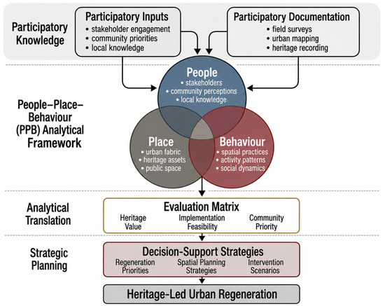
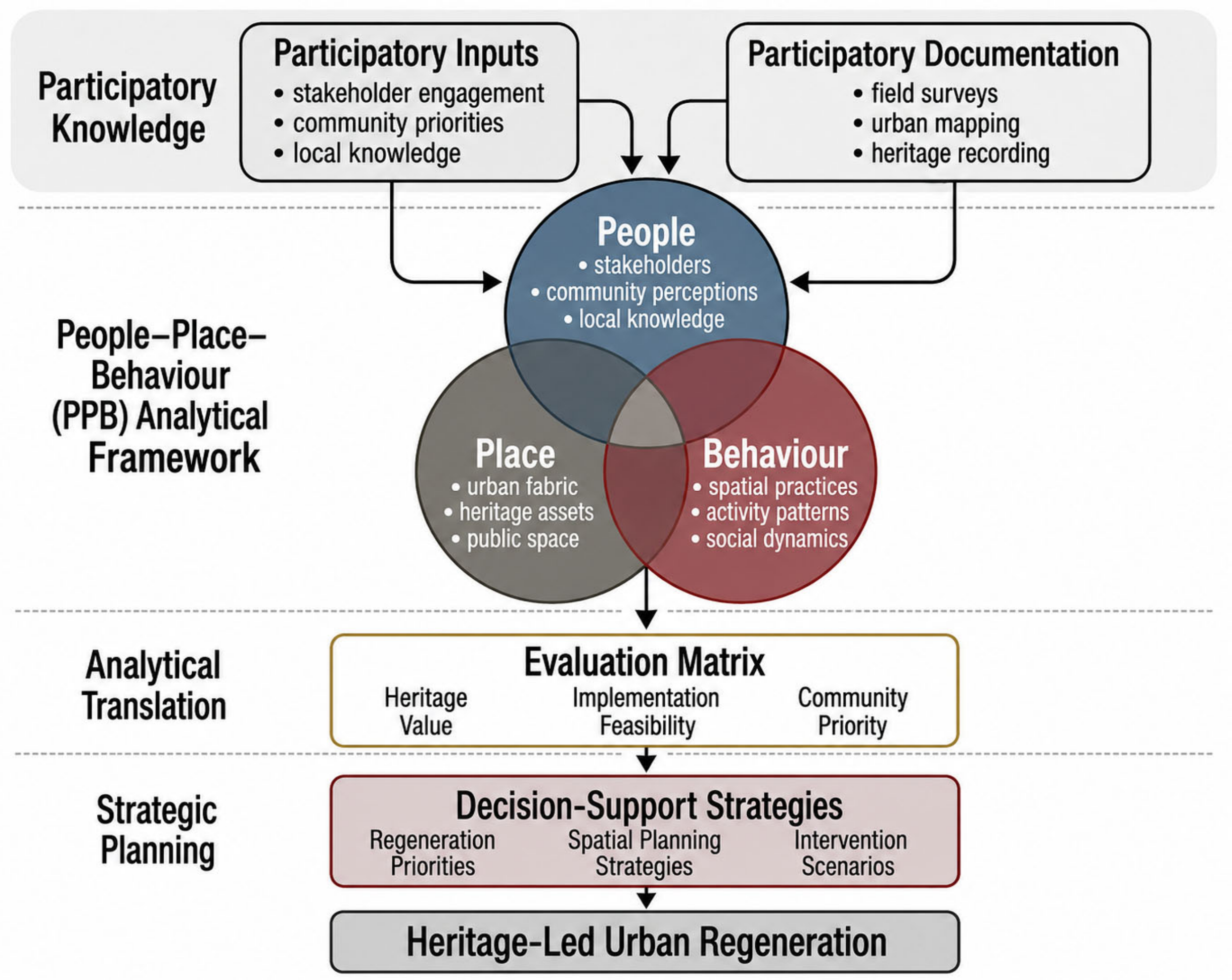
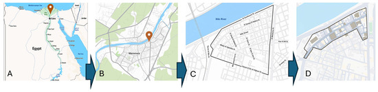
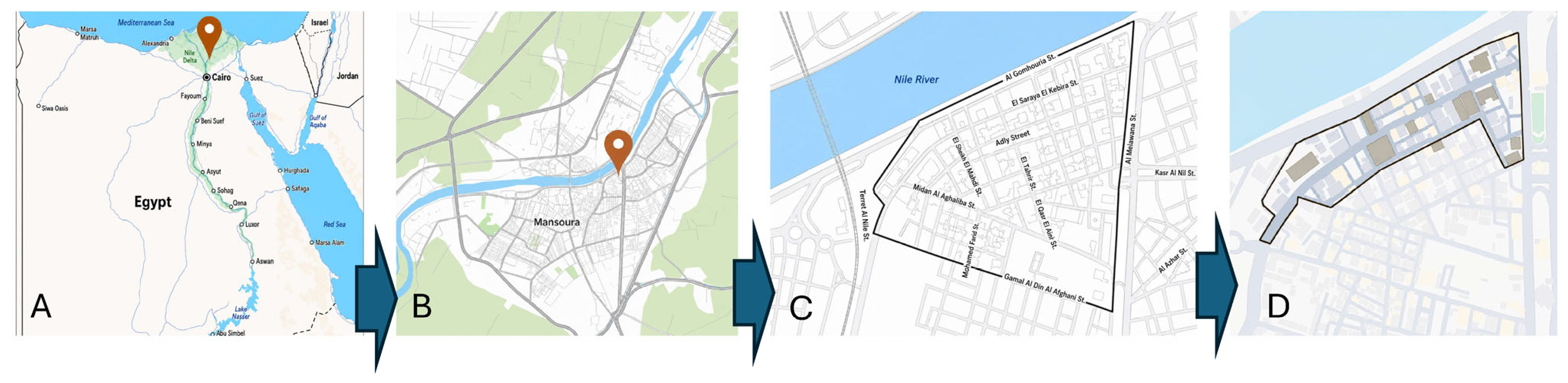
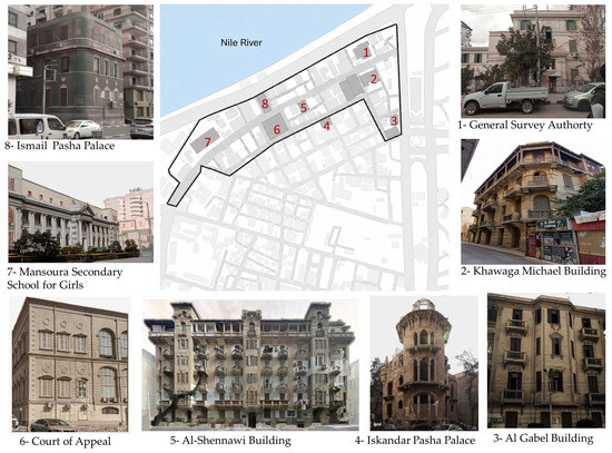
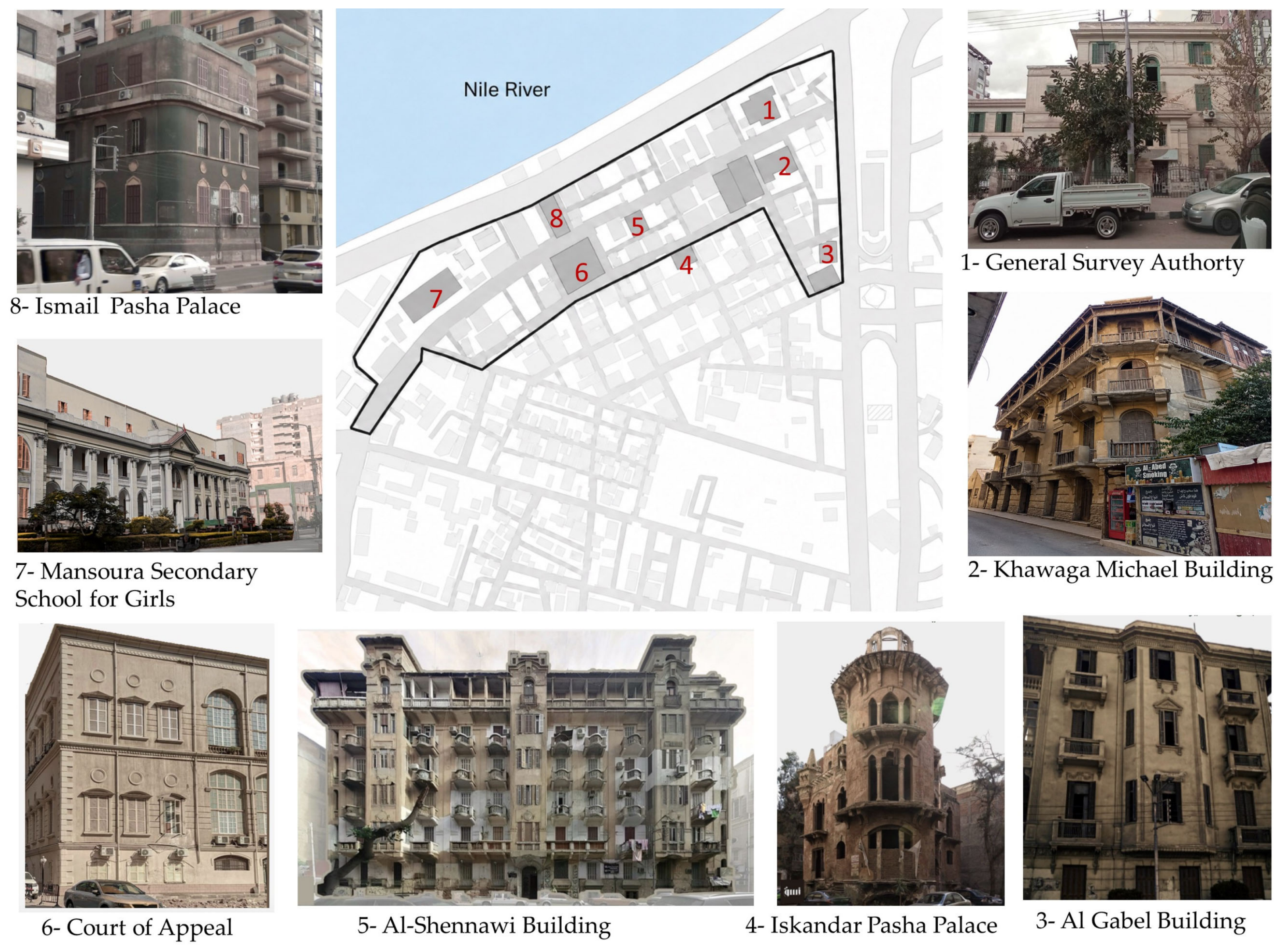
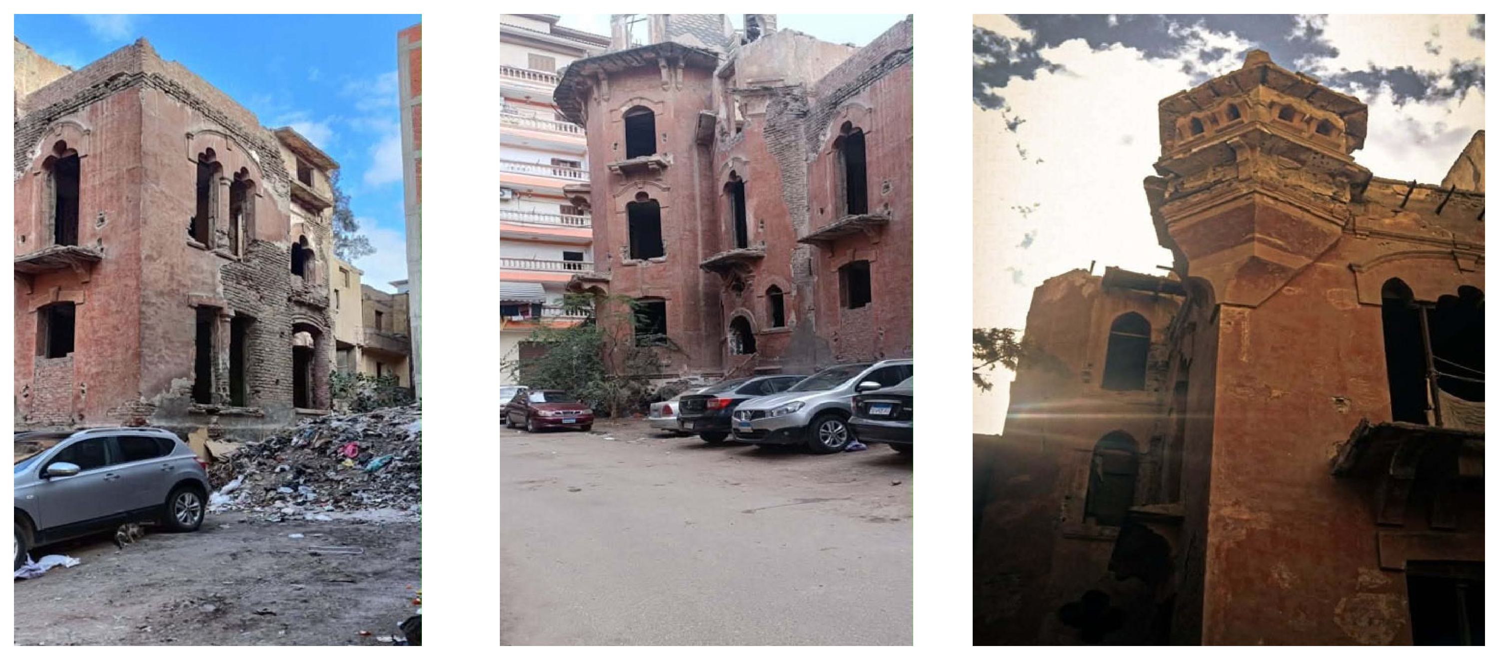
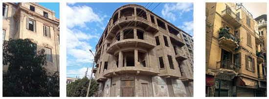
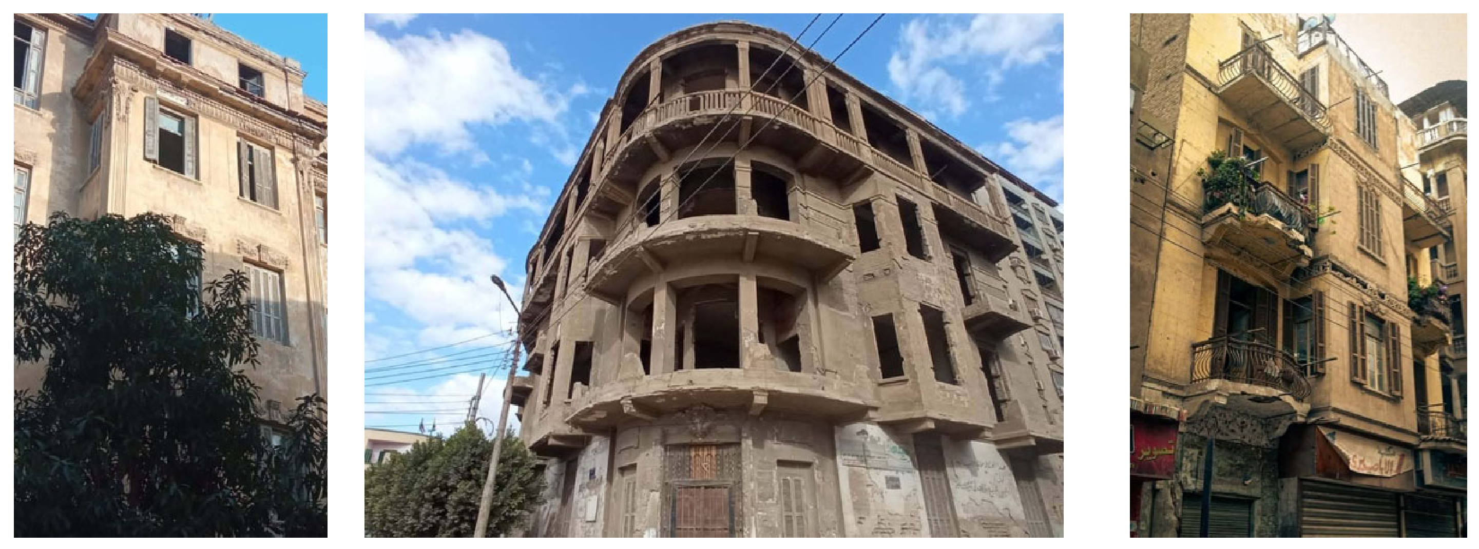
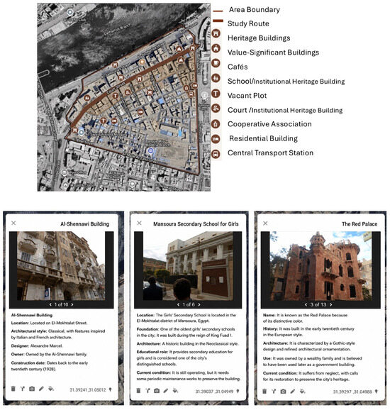
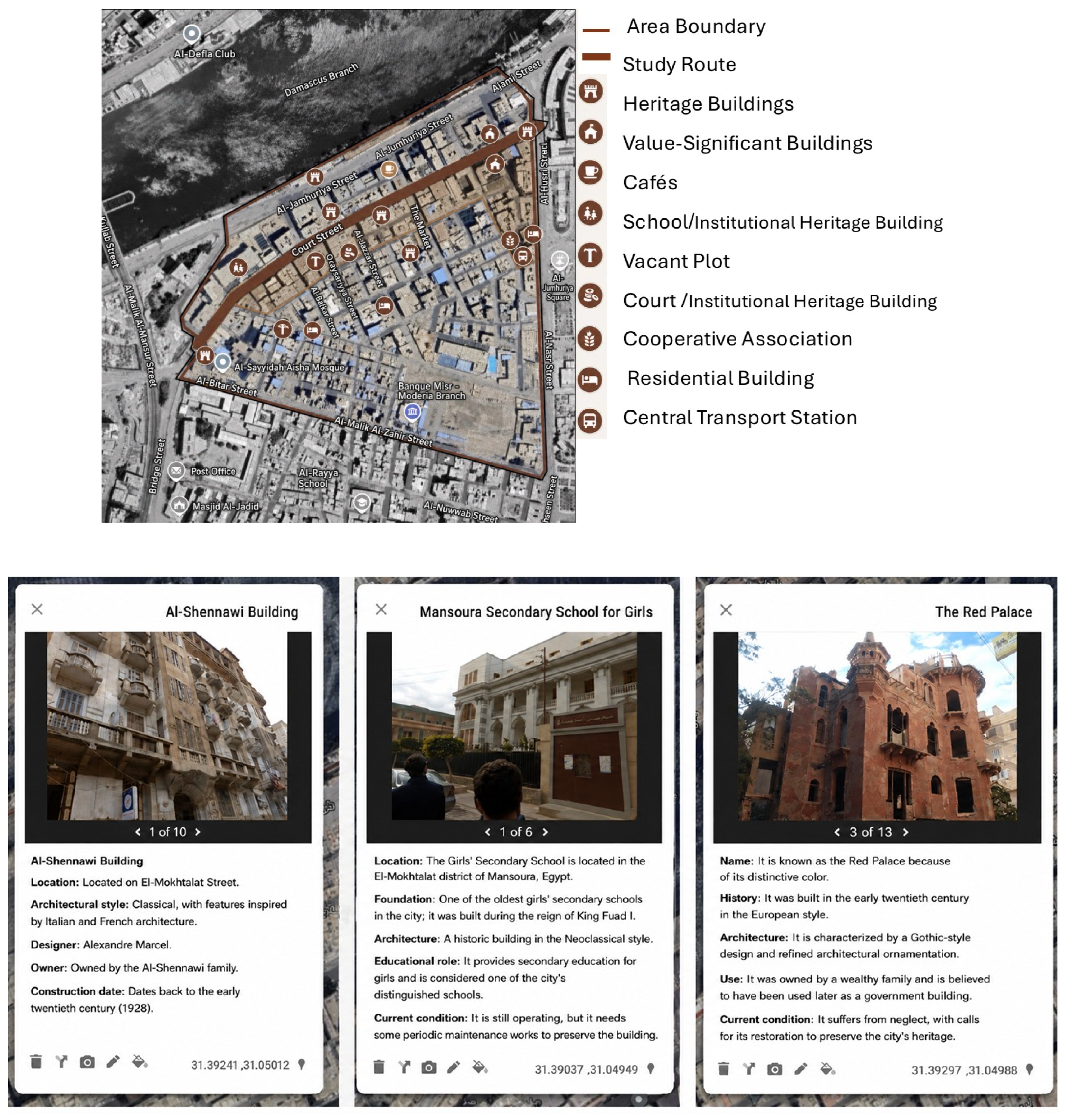
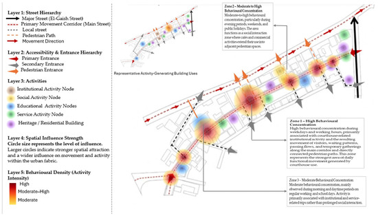
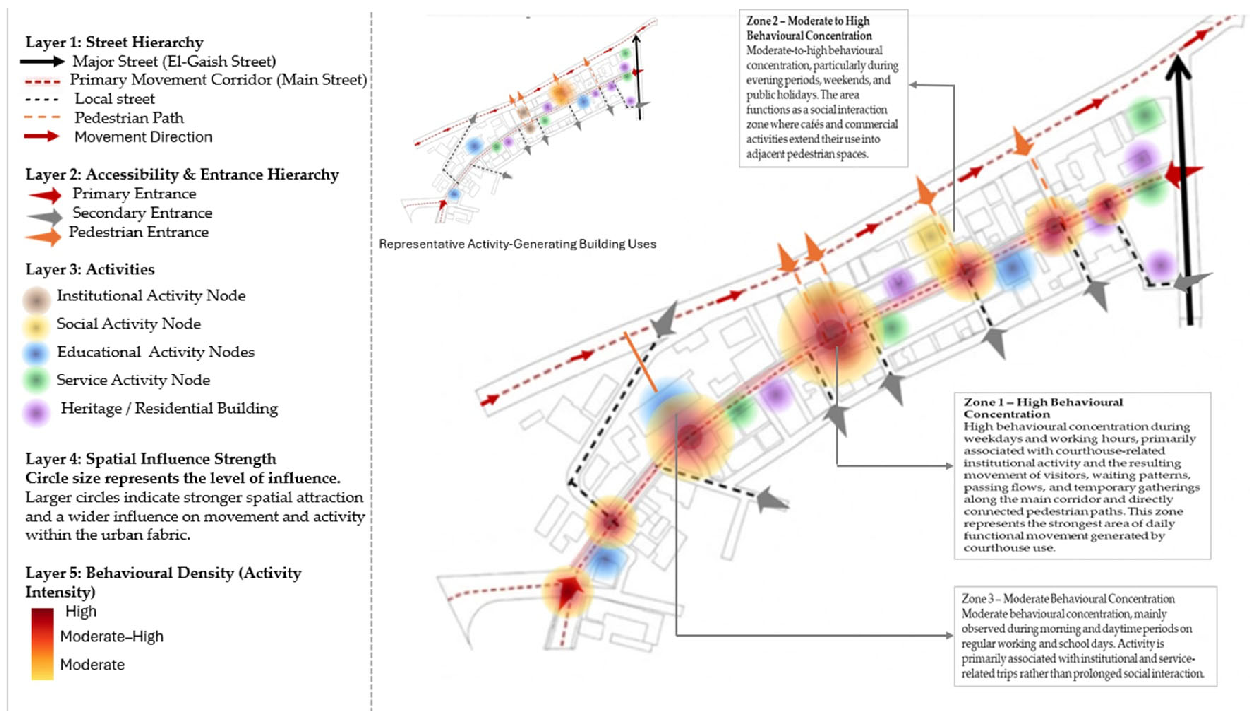
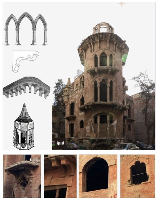
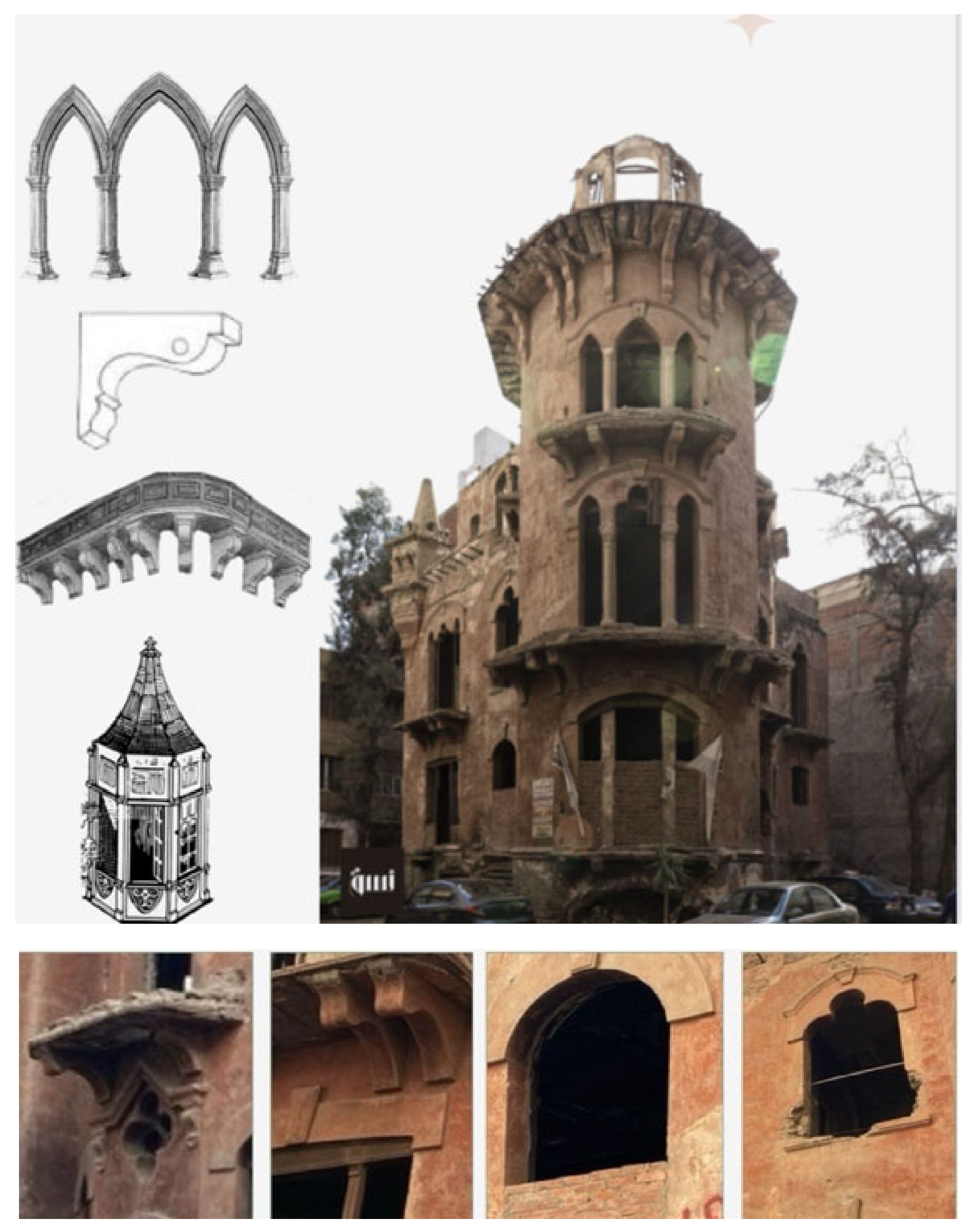
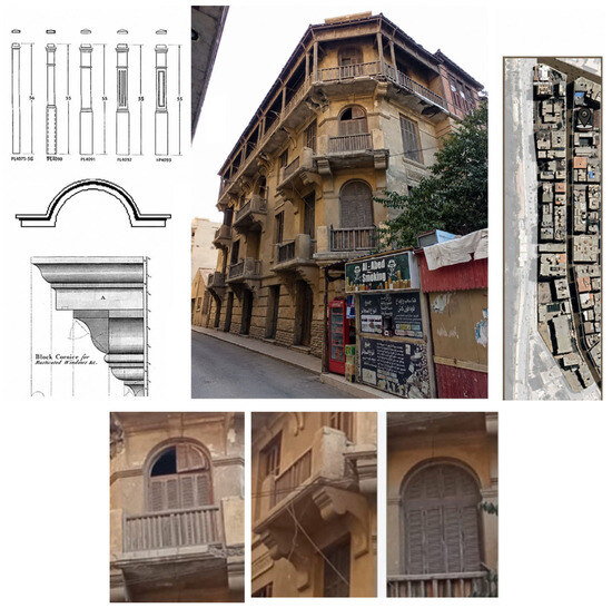
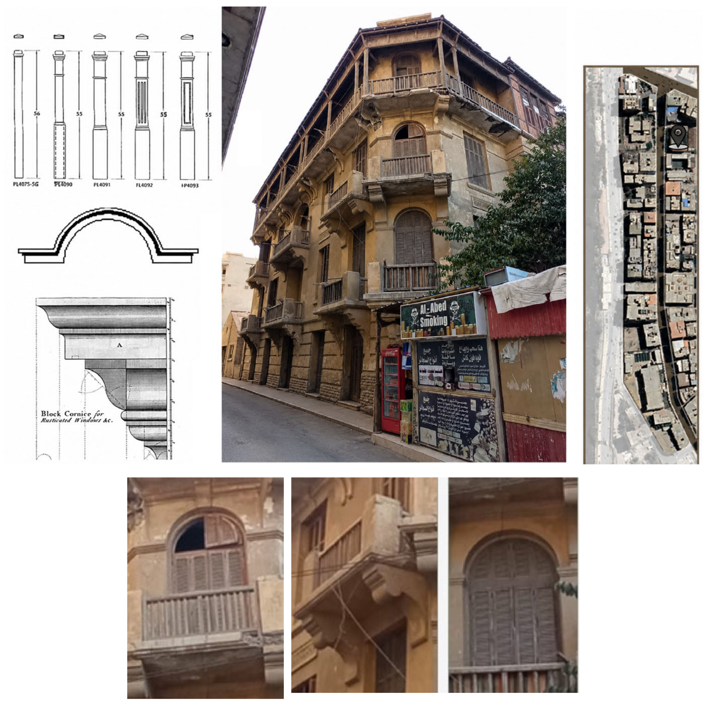
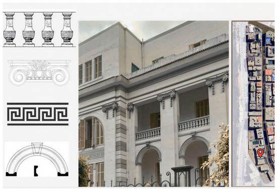
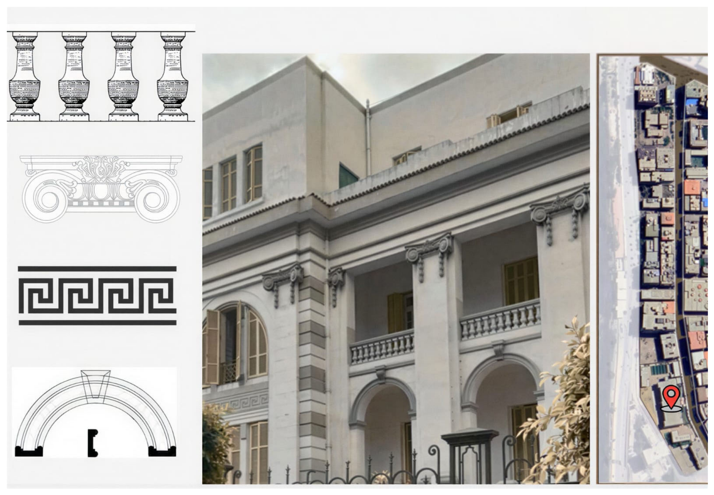
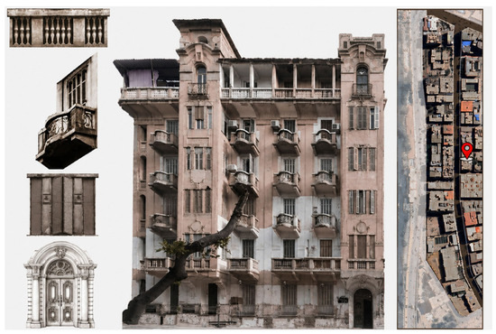
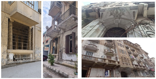
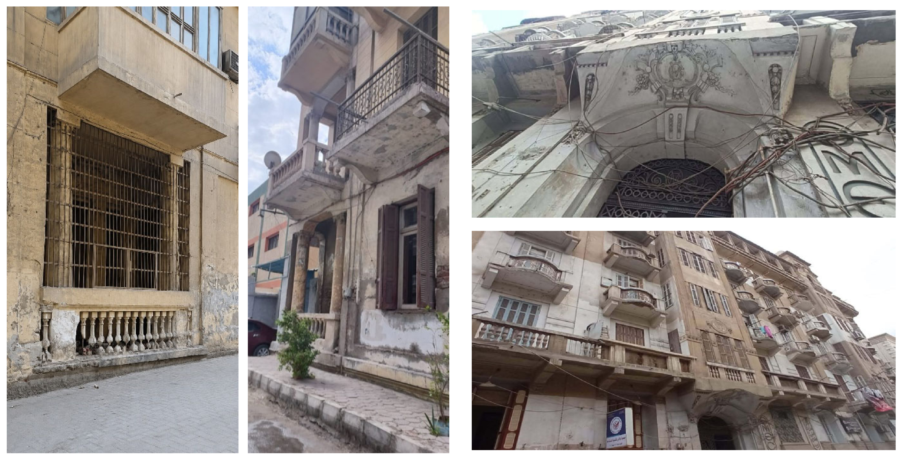

Disclaimer/Publisher’s Note: The statements, opinions and data contained in all publications are solely those of the individual author(s) and contributor(s) and not of MDPI and/or the editor(s). MDPI and/or the editor(s) disclaim responsibility for any injury to people or property resulting from any ideas, methods, instructions or products referred to in the content. |
© 2026 by the authors. Licensee MDPI, Basel, Switzerland. This article is an open access article distributed under the terms and conditions of the Creative Commons Attribution (CC BY) license.