


Abstract
The paper addresses the intersection between modern built heritage preservation and Climate-Aided Design (CADe) processes in fragile coastal Mediterranean contexts. The study focuses on the city of Beirut in Lebanon, part of the Eastern Mediterranean and Middle East (EMME) region and considered a climate change hotspot facing extreme challenges. Rapid urbanization and socio-political instability, especially during the twentieth century, have undermined the city’s ability to mitigate and adapt to future climate change scenarios. Moreover, Beirut’s modern built heritage faces a constant threat of demolition due to the absence of protective legislation, compounded by aggressive real-estate development ambitions. The hypothesis is that the integration of climatic data and regenerative design with modern cultural heritage classification frameworks can aid the preservation process, drive a more adaptive and inclusive approach to urban regeneration, and inform legislative integration of climate adaptation in conservation frameworks. To test this hypothesis, a multi-scalar case-study-based methodology is adopted using a combination of digital tools to assess and analyze the current and future impacts of climate change on two main case studies. First, the St. George Hotel & Bay, one of the first reinforced concrete recreational buildings in the city, was built during the French Mandate (1920–1946) and is vulnerable to sea-level rise, flooding, and demolition. Second, the Beirut City Center “The Egg”, a Brutalist structure built during Beirut’s modernist “golden era”, which is prone to structural deterioration and demolition. The main objective is to highlight 20th-century built heritage as part of Beirut’s spatial narrative worthy of conservation and rehabilitation by analyzing their capability to adapt to, mitigate, or benefit from future environmental risk. Ultimately, the study explores their potential to catalyze climate-resilient urban regeneration practices in the city. Results show that the integration of current and future forecast environmental analyses informed early preservation and intervention decision-making stages to position 20th-century modern built heritage as an asset to climate action in addition to being a socio-cultural and economic asset.
1. Introduction
As one of the oldest continuously inhabited regions in the world, the Levant (Belad Al Sham) has long been known for its urban complexity, diverse cultural identity, and immensely rich history, stretching back to 10,000 BCE. The study focuses on Beirut, Lebanon, a coastal city in the eastern Mediterranean basin. Beirut is in the Eastern Mediterranean and Middle East (EMME) climatic zone, which is considered a climate change hotspot due to its high vulnerability to shifts in both extreme and average climate conditions [1].
According to the Intergovernmental Panel on Climate Change (IPCC) in its Sixth Assessment Report (AR6), the increase in the atmospheric concentration of greenhouse gases during the last two centuries has been driven by human activities exceeding any pre-industrial levels [2]. Over the last three decades, there has been approximately a 50% increase in energy demand in cities because of rapid urban sprawl and growth. Globally, urban areas are responsible for around 67% to 72% of the total greenhouse gas emissions (GHG), while building construction and operation account for 18% and 21% of GHG emissions, respectively [2]. Furthermore, urbanization affects energy consumption, required to meet mobility, heating, and cooling demands. Collectively, they contributed to the Urban Heat Island (UHI) effect because of the anthropogenic heat flux linked to non-renewable energy sources [2].
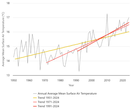
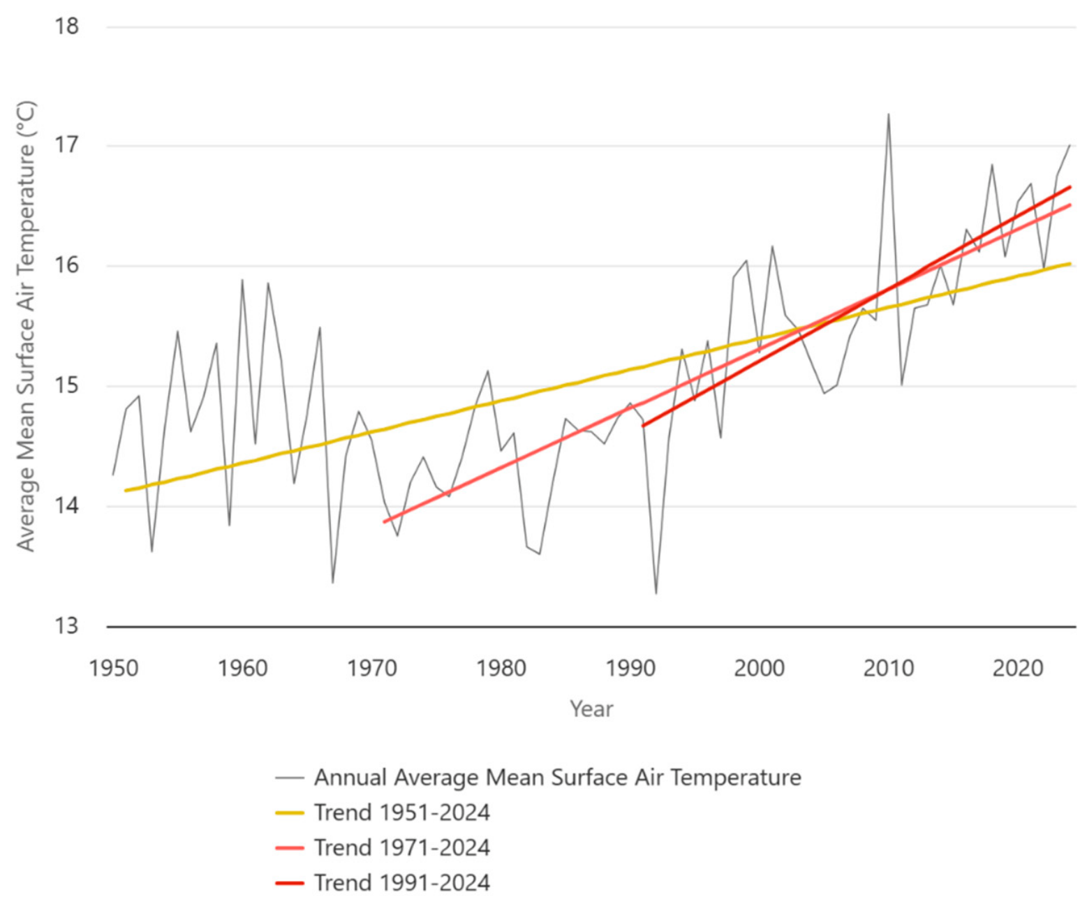
Historically, despite its marginal contribution (about 5%) to global greenhouse-gas emissions, the EMME region is warming nearly twice as fast as the global average [3]. Temperatures are rising by 0.4 °C per decade (Figure 1), and projections indicate this trend will continue for 70 more years [4]. By 2090, temperatures are expected to rise by 3.5 °C on the coast and upwards to 5 °C on the mainland. Under Representative Concentration Pathway (RCP) 4.5, the moderate scenario applied, the mean temperature will increase by 3.1 °C [5] (Figure 1).
Figure 1.
Observed annual average mean surface-air temperature trends in Lebanon, 1950–2024 (Image source: www.meteoblue.com).
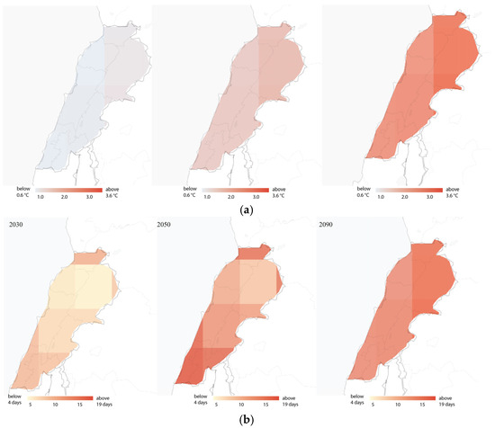
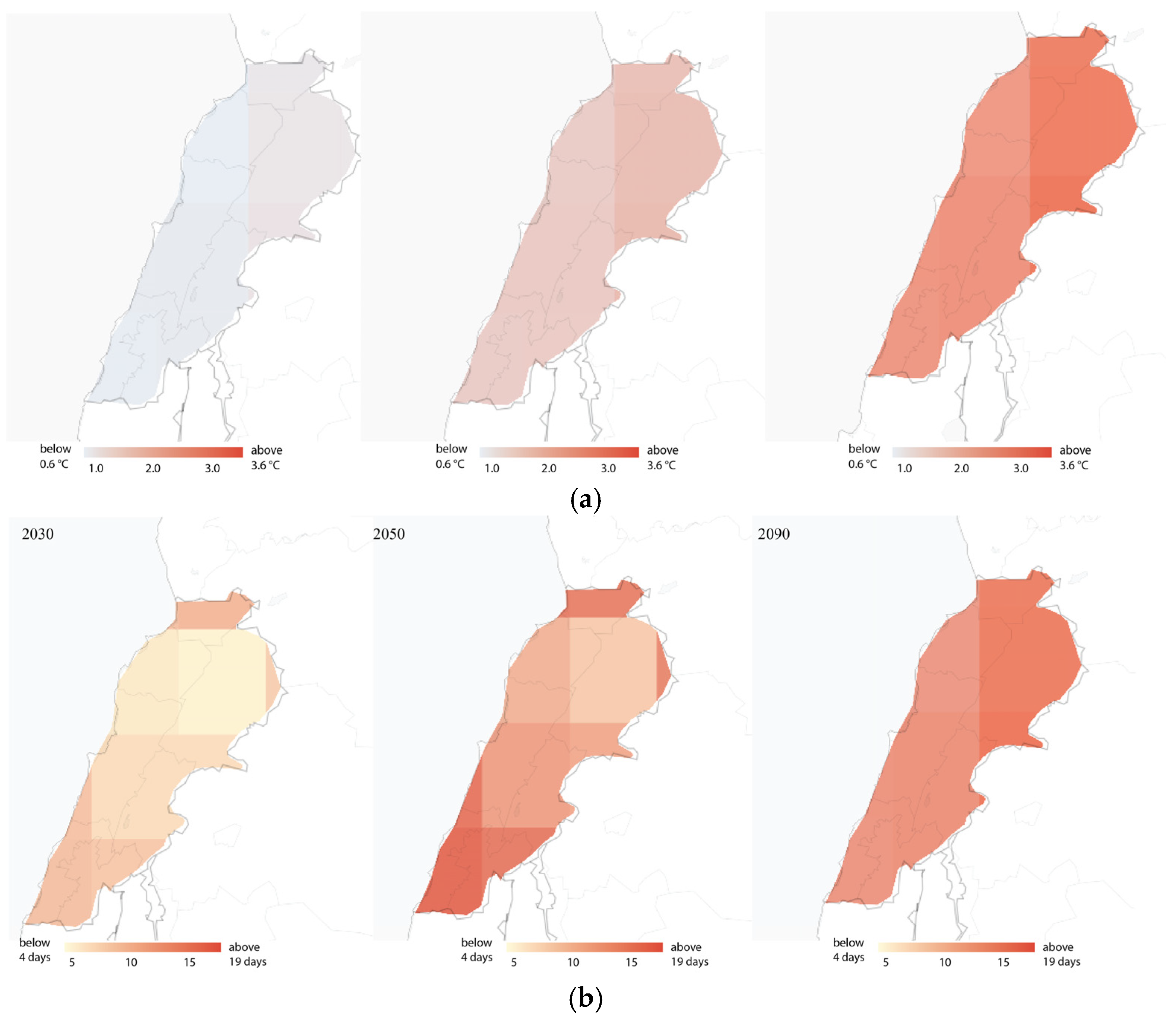
Projections also show more summer days with temperatures above 35 °C and more tropical nights above 25 °C. By 2090, there will be about 25 such days (Figure 2). This is linked to a projected 45% decrease in precipitation and up to a 70% decrease in snowfall by 2090 [6]. These changes will affect river and groundwater recharge and could increase drought days by 9 to 18 days by 2090 [6].
Figure 2.
(a) Projected absolute change in mean air temperature (°C) in Lebanon for 2030, 2050, and 2090 under RCP 4.5; (b) projected days per year with high heat risk (HI > 32.2 °C) in Lebanon for 2030, 2050, and 2090 under RCP 4.5. Image source: Climate Impact Explorer (Climate Analytics & IIASA), derived from ISIMIP3b simulations; ISIMIP3a and ISIMIP3b datasets are distributed under a CC0 Public Domain Dedication license.
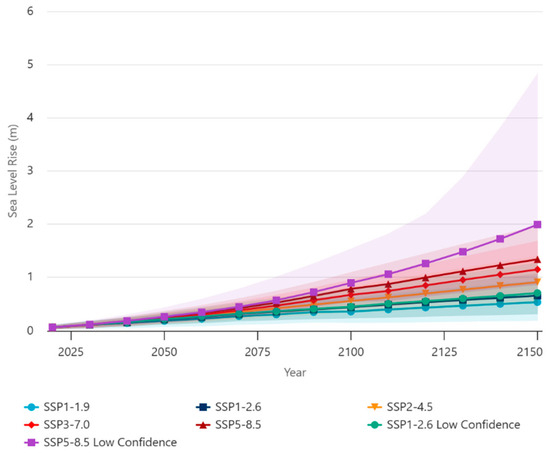
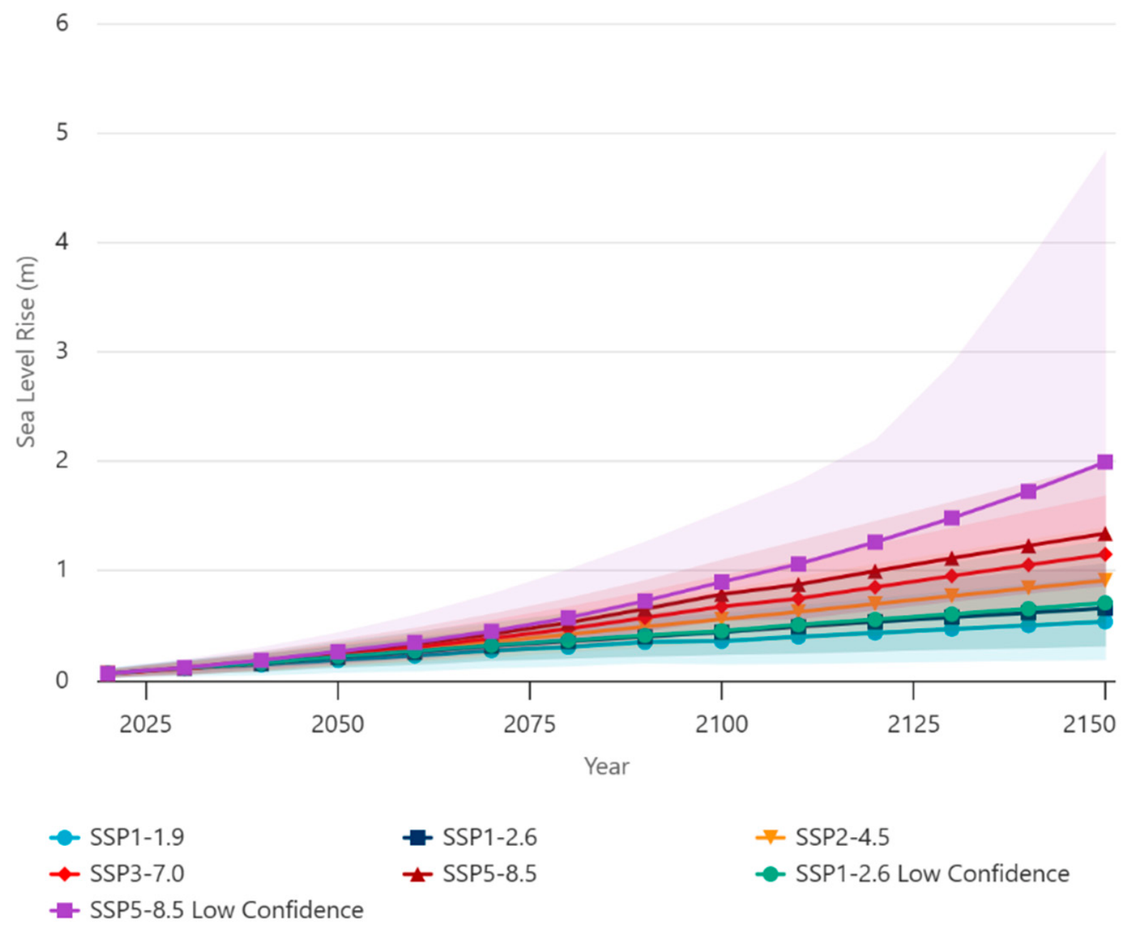
These changes will deeply affect Lebanon’s environment; drought, wildfires, and sea-level rise will threaten already fragile ecosystems and natural habitats. By 2090, a shift to warmer conditions and higher humidity levels (with ratios of 0.025 kg water/kg air) will reduce hours of thermal comfort for both indoor and outdoor spaces. This projection indicates an increased likelihood of extreme heat events and suggests that maintaining thermal comfort through passive strategies alone will become increasingly challenging [7]. According to The Lebanese Red Cross report, by 2100, it is forecasted that sea levels in coastal cities will be 80–100 cm higher (20 mm per year). Around 90% of the population lives in these coastal areas (Figure 3) [8]. Therefore, the risk of coastal flooding and saltwater intrusion into coastal aquifers will rise.
Figure 3.
Projected total sea-level rise for different future years under different Shared Socioeconomic Pathways (SSPs), relative to 2005 (1995—2015). Image source: World Bank Group, Climate Change Knowledge Portal: Lebanon Projections [6].
Coastal capital cities such as Beirut face a pressing challenge in mitigating and adapting to future climate change scenarios, compounded by the decades-long gradual dismantlement of the state’s governance capacity, leading to inadequate infrastructure, rapid formal and informal urbanization, and neo-liberal ambitions that reinforced spatial and wealth inequality [9]. The United Nations (UN) report mentions that around 68% of the world’s population will live in cities and urban areas by 2050 [10]. However, in Lebanon, more than 80% of the population has already been living in urban areas since 2014. In 2020, this number reached 94% [11].
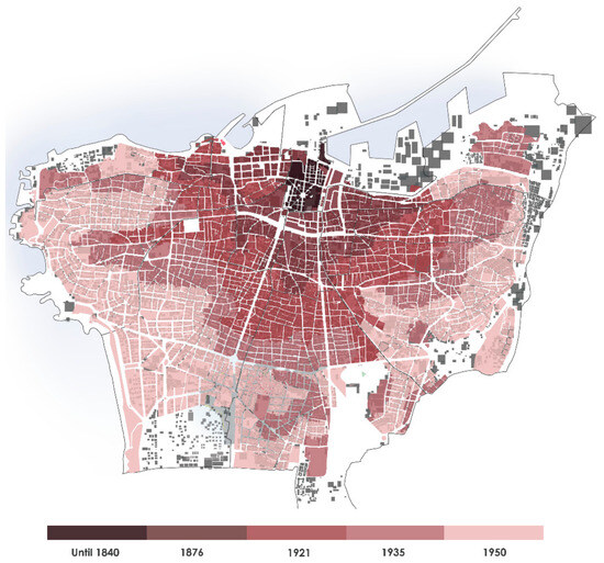
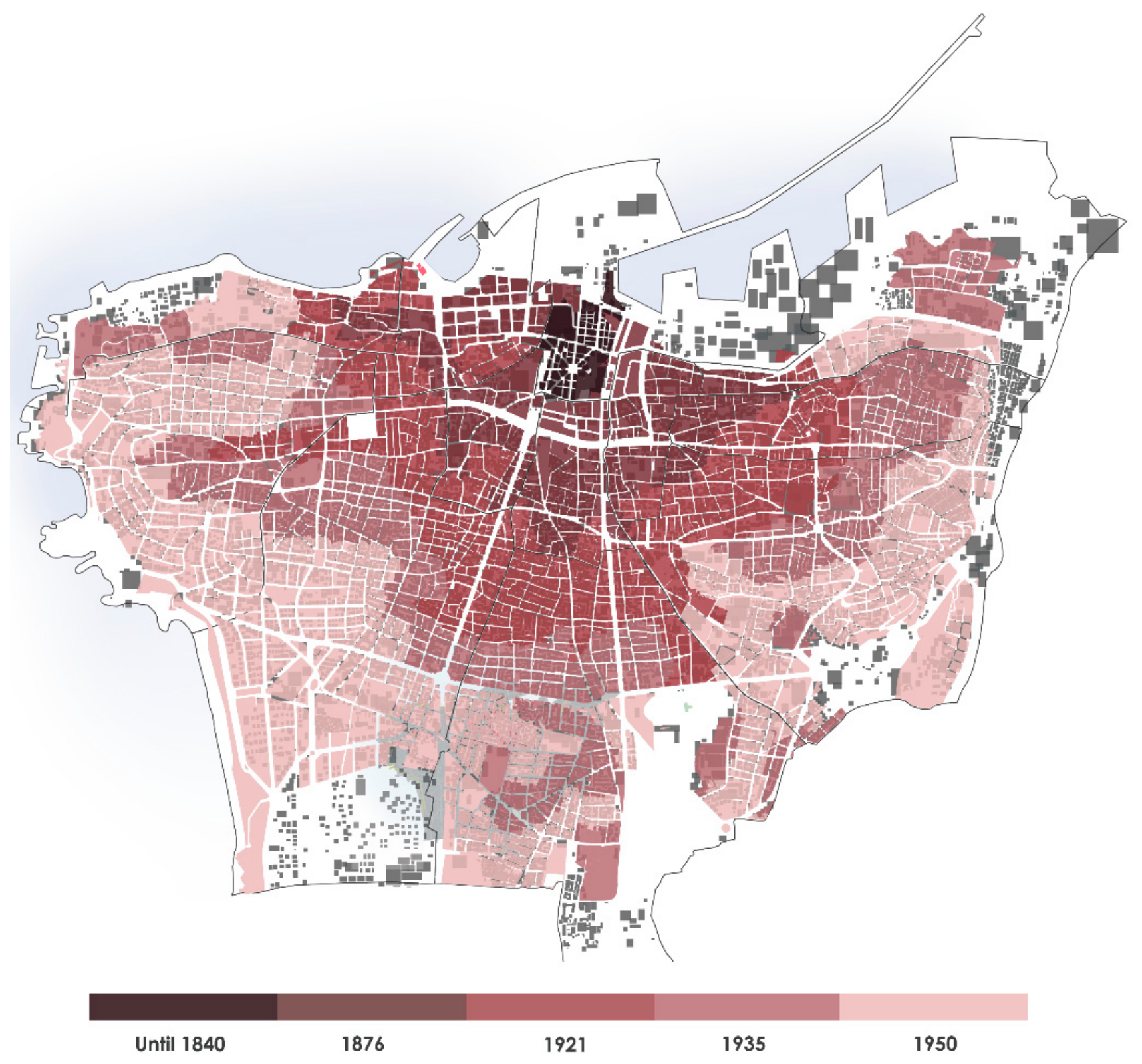
Ever since Lebanon’s independence in 1943, there have been no accurate population figures for Beirut City. Estimates show Beirut’s population grew from around 350 thousand to around 2 million in 2025 (Figure 4), accounting for a population density of 19,509 persons/km2 [11]. Urbanization has resulted in the extensive consumption of available land resources, both horizontally and vertically, especially after the Lebanese Civil War (1975–1990). Approximately 77.3% of Greater Beirut was urbanized as of 2021. The aftermath of this unregulated density is a severe scarcity of urban green infrastructure, which represents less than 1.5% of the city’s area. Studies report a 6 °C temperature difference between dense urban areas and high vegetation patches of the city during summer periods, ranging from 44.6 °C to 37.6 °C [12,13].
Figure 4.
Urban expansion in Beirut from 1876 to 1950. Expansion in land use after 1950 plotted in grey. The St.George hotel is highlighted in magenta. (Image source: author’s original drawing using Beirut Urban Lab GIS data).
In parallel with the urban sprawl, the city underwent successive waves of destruction before, during, and after the civil war. Therefore, with each wave of destruction, Beirut loses part of its spatial narrative and identity. In this context, destruction compounds the environmental challenge and intensifies climate change impacts as buildings lose their previously embodied carbon, while reconstruction costs increase the energy demand and generate additional carbon emissions [14]. In Beirut, surprisingly, the destruction that occurred after political conflicts such as the civil war surpassed the damage produced by the war itself, as new construction prioritized economic private stakes over sustainable development [9]. In a future where excessive urbanization will be prevalent, culturally significant structures may face a persistent risk of demolition.
1.1. Aims and Scope
The paper examines the emergence of architectural experiments within the city during the 20th century and their sequential role in shaping Beirut’s modernist layer, representing its contemporary urban condition. Furthermore, it analyzes the challenges these structures face in maintaining their presence, their marginalization in relation to formal recognition as components of the city’s tangible heritage, and their potential to act as catalysts for urban regeneration. The main goal is to showcase historically and symbolically significant 20th-century buildings as key drivers of climate-resilient urban regeneration processes towards a more adaptive and inclusive approach to conservation.
Furthermore, the study defines a methodological framework that integrates environmental design practices using digital tools and climatic projections to aid the rehabilitation process as a form of climatic action. This ultimately equips vulnerable structures against the threats of demolition through mitigating, adapting, and, where possible, leveraging opportunities related to future climate change risks. The hypothesis is that the integration of a CADe methodological approach, including climatic data as a primary generative tool during early design stages, with modern built heritage conservation frameworks can facilitate preservation decisions and reposition non-listed modernist structures as drivers of climate-resilient urban regeneration practices.
The study draws attention to part of Beirut’s spatial narrative, its endangered buildings, and its contested urban landscapes. Specifically, 20th-century modernist developments, mainly located around the Central Business District (CBD), have evolved since their realization in response to the spatial and political transformations of the city. The paper focuses on two non-residential modernist architectural interventions in Beirut’s City Center, The Saint George Hotel & Bay (1929) and the Beirut City Center building (1965). The scope of the study involves three parts. First, it conducts a historical and theoretical analysis to establish the cultural and urban value of both buildings within the city’s context. Second, it conducts a multi-scale environmental analysis, from the district to the building scale, using digital tools to evaluate the current state and future climate projections under RCP 4.5. Third, it proposes data-driven site-responsive interventions that address the climatic vulnerabilities and aid the regeneration process of the sites. The paper aims to address the following questions:
- How can the climate-adaptation and mitigation strategies, supported by a multi-scalar environmental assessment and projection methodology, aid the conservation and rehabilitation process of unlisted culturally notable modernist buildings in fragile Mediterranean coastal cities like Beirut?
- How can the conservation and rehabilitation practice be conceived as a climatic action alongside a cultural-identity preservation action or an economic action?
1.2. Case Study Selection
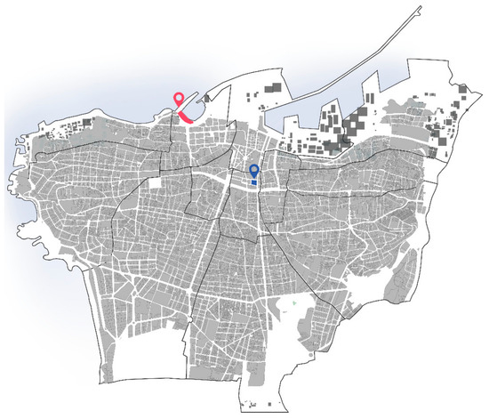
The criteria behind the case study selection were as follows: (1) geographical proximity to permit comparative urban-scale analysis, (2) historical periodization, representing two different historical periods, (3) symbolic and architectural significance, (4) mutual vulnerabilities and opportunities. The two cases were selected as representative of Beirut’s broader modern pre-war built heritage at risk. The first case study is considered one of the first reinforced concrete buildings in the city and a novel precedent that showcases the modernist ideals of the French Mandate, the St. George Hotel & Bay [15]. The second case study, the Beirut City Center “The Egg”, emerged during the country’s post-colonial era, marked by scholars as the golden age of Modernist Architecture in Lebanon, where literature of decolonization and efforts to forge a new national identity surfaced (Figure 5) [16].
Figure 5.
Location of the case studies. The St. George Hotel & Bay is shown in red, and Beirut City Center in blue (Image source: author’s original drawing using Beirut Urban Lab GIS data).
Despite their different historical contexts, both buildings share a common symbolic value to the city’s collective identity. Moreover, both cases represent original interventions in the city’s fabric. They have each witnessed multiple waves of destruction and urban change. Both buildings have remained unoccupied since the civil war (1975–1990) and endure the risk of demolition as they are not officially listed as part of Beirut’s built heritage. Concurrently, both sites share similar climatic risks, a lack of sufficient indoor and outdoor thermal comfort, and an imminent vulnerability to sea-level rise due to their coastal location. However, the Beirut City Center “The Egg” remains in an advanced state of structural deterioration and neglect.
1.2.1. The St. George Hotel & Bay
Designed in 1929 and built in 1933–34 during the French mandate by the French firm of Poirrier, Lotte, and Bordes, and Lebanese architect Antoine Tabet, the building is located on the waterfront in Beirut’s CBD [15]. During this time, the first airport was built, and Beirut was established as a major port connecting the East to the West. Consequently, tourism became popular, and construction of private hotel resorts along the coastline began [17,18].
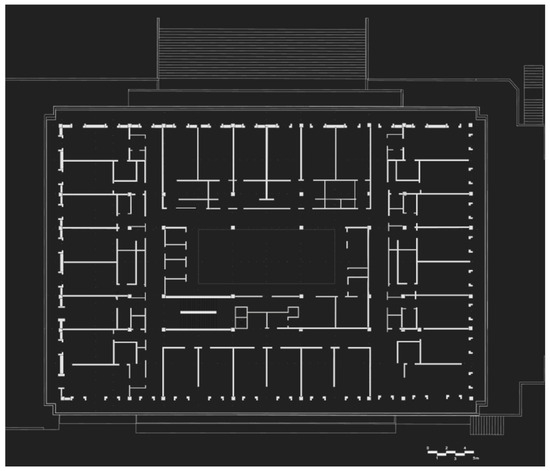
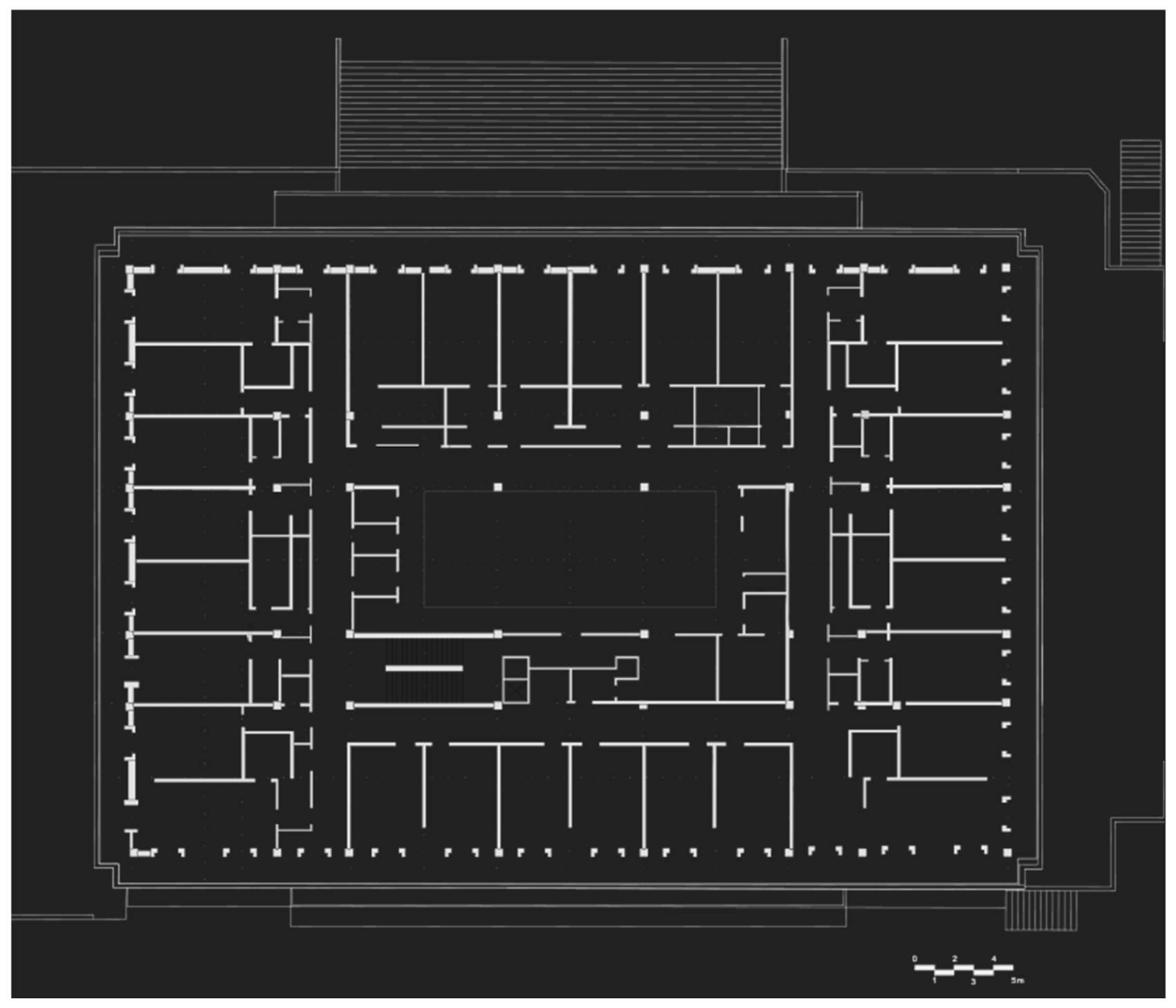
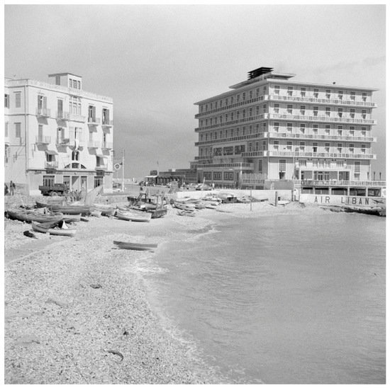
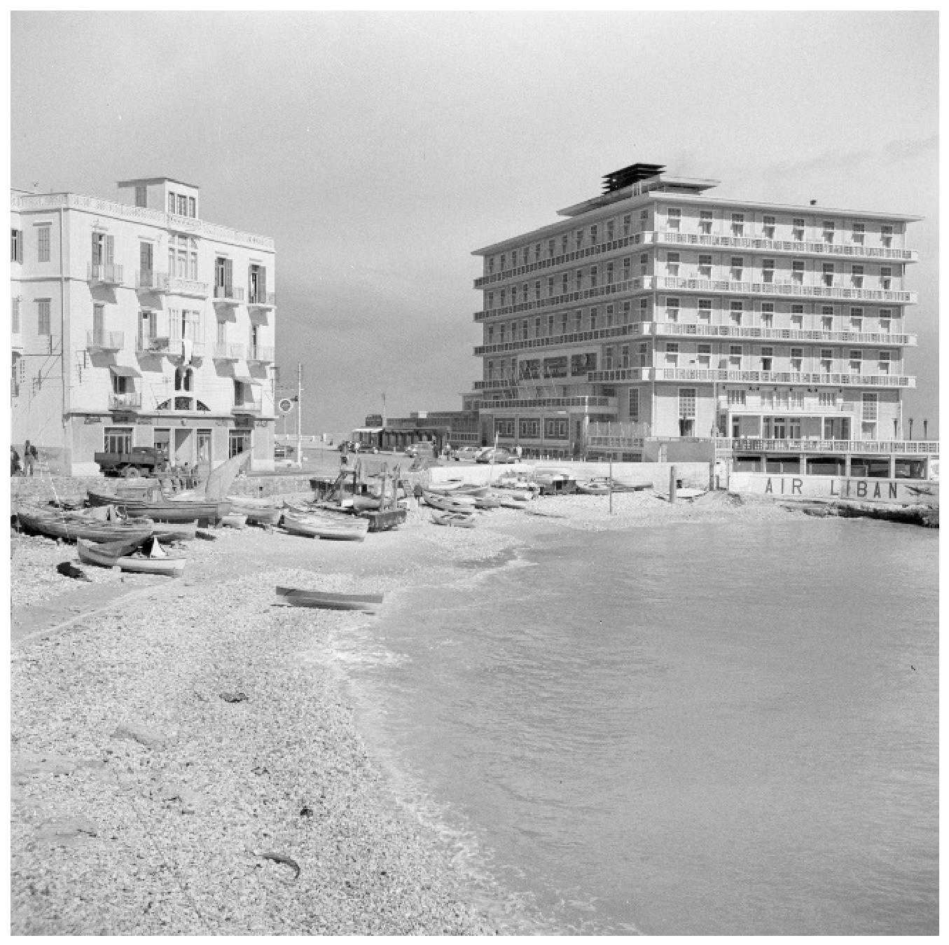
The construction of the Avenue des Français in 1925 facilitated the hotel’s development, which took place across the two bays of Zaytouni and Ras Minet el-Hussain tip, later called Saint George Bay, and the area became known as the Hotel district. By the 1960s, it held the reputation of being the most luxurious hotel in the Middle East [17] and was considered one of the world’s seven best hotels. The hotel sector was flourishing, and the Saint Georges Hotel was authorized under Decree no. 2660 (1959) to acquire an additional 2000 m2 of maritime public property for the marina and underwent further expansion [18]. The design was highly influenced by the Parisian architect Auguste Perret, with its exposed concrete structure and its modular grid arrangement of 7 × 7 m, 7 × 3.5 m and 3.5 × 3.5 m grids, which was highly unusual at the time in Beirut (Figure 6, Figure 7 and Figure 8).
Figure 6.
The St. George Hotel & Bay 2019. (Image source: Onceinawhile, Wikimedia Commons, 2019, licensed under CC BY-SA 4.0 [19]).
Figure 7.
The St. George Hotel’s typical floor plan diagram during the 1930s. (Image source: author’s original image with information obtained from Arab Center for Architecture).
Figure 8.
The St. George Hotel & Bay during the 1950s. (image source: Poll, Willem van de, National Archives/Van de Poll Photo Collection [20]).
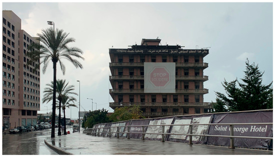
Nevertheless, the hotel district was the main scene of conflict, especially during the first two years of the civil war, known as “The Battle of the Hotels”, and after the initial ceasefire in 1976, the Saint George Hotel became a Syrian prison until the end of the war [18]. In the aftermath of the war, most of the hotels recovered; the Saint George Hotel went through multiple phases of restoration. However, rapid and unstudied restorations highly affected the climatic performance of the building. In addition, it struggled with any form of utility and was threatened multiple times with demolition because of the legal battle with a joint stock company called SOLIDERE (Société Libanaise pour le Développement et la Reconstruction du Centre-ville de Beyrouth) [17,18].
1.2.2. Beirut City Center “The Egg”
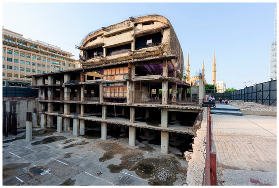
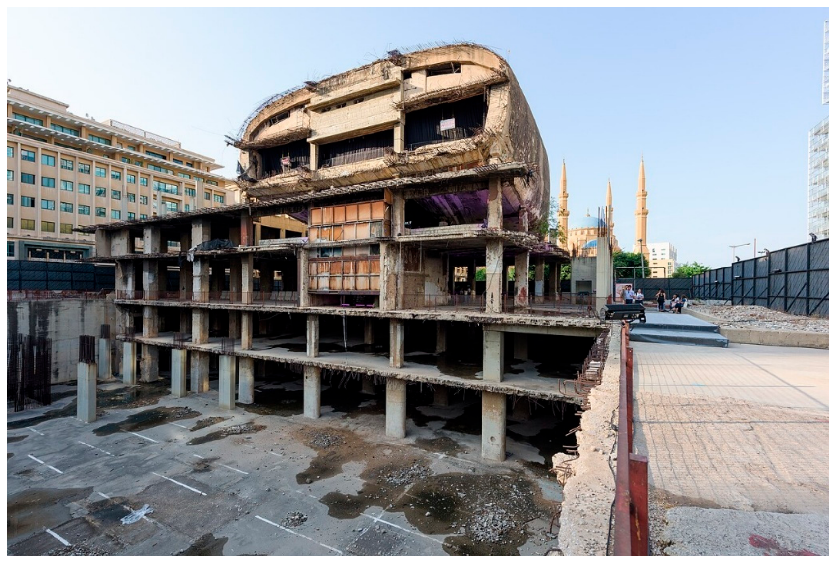
The second case study is a heavily scarred monument in the middle of Beirut that is profoundly shaped by Lebanon’s socio-political history. Originally designed by the Lebanese architect Joseph Philippe Karam in 1965, the building was a multi-use complex, consisting of a shopping center, two office towers, and an egg-shaped shell housing a cinema. It was intended to be the largest commercial center in the region at the time [21]. However, the building was not completed due to the Lebanese Civil War in 1975. Today, the building stands unoccupied, facing threats of demolition due to decades of deterioration and neglect following the Civil War (Figure 9).
Figure 9.
The Egg—Beirut City Center in 2018. (image source: By Emmeca-Self-photographed, CC BY-SA 4.0, https://commons.wikimedia.org/w/index.php?curid=73802584 (accessed on 7 July 2026)).
The building sits in a strategic location in downtown Beirut, fronting Bechara El Khoury Street and overlooking the historic Martyrs’ Square, designated in 1931 to commemorate the martyrs executed at the site under Ottoman rule. By the 1950s, the area had evolved into a prominent social and cultural hub, defined by the emergence of cinemas, hotels, and coffeehouses. During the Lebanese civil war, the square assumed a strategic role as part of the separation line that physically and symbolically divided the city between Muslim-majority factions in West Beirut and Christian-majority areas in East Beirut. Once a symbol of the city’s division, the former separation line now offers The Egg an opportunity to bridge and reconnect the urban fabric [16].
The original design by Karam can be seen as an influence from that period’s works of Le Corbusier, Oscar Niemeyer, Claude Parent, and others, with a fluid modernist design, as well as a bold brutalist expression of that era. A notable example of this Brutalist influence is found in the work of Claude Parent, particularly in the Church of Sainte-Bernadette de Banlay in Nevers, France [16].
The importance of the cultural value of The Egg lies in its rooted connection to the Lebanese population, in terms of their common resilience throughout multiple periods of conflict; the start of the Lebanese Civil War has left only The Egg (The Center’s Cinema), the platforms and pilotis, the underground parking, and one tower out of two, which ended up being demolished during the war. Even after three decades of planning and reconstruction, Beirut’s urban fabric continues to exhibit war-scarred buildings situated among newly developed, investor-oriented projects. The site was sold in 2005 by Solidere to Abu Dhabi Investment House (ADIH) within the framework of the Beirut Gate development project. Furthermore, the land was transferred by Solidere without any legal protections or financial incentives for The Egg’s preservation, rendering its eventual demolition highly probable [21].
As a result, widespread criticism has been directed at capitalist enterprises like Solidere, for the Dubai-ification of Lebanon, and resistance to the rapid commercialization and aesthetic homogenization reminiscent of the Gulf urbanism. Nevertheless, the outbreak of the July 2006 war temporarily halted its immediate destruction, while the subsequent financial crisis further postponed redevelopment plans [16,21]. Given the cumulative implications of war, financial crisis, and political instability, The Egg has become a centerpiece in the battle for identity, not just of the downtown area, but of Lebanon as a whole. Politics has always played a crucial role in shaping Lebanon’s identity and has been many times a deciding factor in the fate of architectural elements and infrastructure. The Egg, whose usage has gradually reflected its socio-political context, acts today as a mirror of its era and a symbol of revolution, resilience, and resistance. When the revolution broke out in October 2019, The Egg found a new purpose as a gathering point for protesters. People filled it with graffiti and repurposed it for film screenings, among other activities that became emblematic of the protests. Once a highly anticipated project, The Egg now stands as both a reminder of the city’s turbulent history and an enduring symbol of its evolving identity [21].
1.3. Background
1.3.1. Historical Background
Beirut’s history stretches back to the 15th century BCE. Situated at the crossroads of maritime trade routes, the city grew from a Phoenician port and stratified into 13 layers, including Persian, Roman, Byzantine, Umayyad, Abbasid, Mamluk, and other successive layers. Beirut is a city that was destroyed and rebuilt seven times. This stratification throughout the centuries contributed to the city’s current cultural landscape. However, the city’s transformation and expansion accelerated during the late 19th century under Ottoman rule with the so-called Tanzimat (Reorganization or reforms) era. The Ottomans designated Beirut as an example of their “modern” reforms, following a European-style urban infrastructure. By 1888, Beirut had become a Wilâya (a provincial capital) with around 4000 inhabitants [22,23].
According to Robert Saliba, Beirut city was significant during two periods of its history. The first was the Roman period, when it was a Roman colony, and the second was during the nineteenth and early twentieth centuries, when Beirut emerged as a French colonial experimentation field [23]. In the aftermath of the First World War, the Ottoman Empire collapsed, and its territories fell under French and British colonial rule. At this time, Lebanon, under French rule, underwent another process of transition where new techniques, styles, and construction materials like reinforced concrete were introduced [24].
However, according to Nadine Hindi, both powers, the Ottoman imperialist reforms and the French authority “mission civilisatrice” had similar missions. Their plans overlapped to transform Beirut from a medieval town into a major port. Consequently, this overlap of missions allowed Beirut city to be reorganized to exhibit a hybrid of local architecture with a Western “Parisian” style influence. Ottoman-era plans were utilized and superimposed upon by the Danger plan (1932) and the Delahalle plan (1934). As a result, the process of “Haussmannization” caused a major wave of the old city’s destruction (Bayrout al-Qadima) and its expansion beyond its former walls by importing urban practices through regenerating the existing urban landscape. The French promoted a city of culture on an international scene by leveraging the main characteristics of French planning, hygiene, aesthetics, and circulation. By the late 1930s, streets were widened, tramways and cars were introduced, and hotels and locandas (inns or guesthouses) multiplied along the waterfront [25].
During the Second World War, Lebanon gained its independence, and Beirut was left with a distinct architectural legacy. Even though neither policy nor practice during the colonial era was necessarily intended to benefit the local communities or express local culture, they marked a memorable milestone that shaped the city’s image and identity in its post-independence era [18]. During the decades following independence, a complete modernist agenda was being forged in Lebanon, where architecture would act as a catalyst for social reforms. Robert Saliba calls this era a period of ‘High Modernity’ where infrastructural projects, like ring roads, and new zoning laws were introduced [26].
1.3.2. Modernism in Beirut
The aim was to shape an anti-regional identity unique from any French colonial or Pan-Arab affiliations. As the old historical pre-colonial core had almost disappeared, the only remaining townscape expressing a historical dimension was Beirut’s recent colonial heritage. Between the 1950s and the 1970s, novel forms of architectural expression were welcomed, the commerce and tourism sectors boomed, and Beirut was described as the ‘Paris of the Middle East’. This era was highlighted as the golden age of Modern Architecture in Lebanon, where the spread of a more responsive modernist language took off, and the use of fair-faced concrete gained momentum. Lebanese architects like Assem Salam and Pierre El Khoury, who mainly received their education in the West, were influenced by the modernist ideals of Le Corbusier and Oscar Niemeyer and attempted to contextualize these ideals to address local climate and culture [27,28].
However, Fawaz Traboulsi, in his book A History of Modern Lebanon, explains that post-independence Lebanon’s political and economic scene was controlled by an oligarchy of around 30 families that eventually contributed to rising inequality and corruption. Also, this system was eager to maintain and benefit from the existing inherited colonial practices [22]. According to Nasser Rabbat, post-colonial regimes did not reject colonial urban policies but rather expanded them, especially those tied to modernization and state control of space [29]. Eric Verdeil shares a similar view, stating that “Architecture and urban planning in the post-colonial state of Lebanon originated from the colonial initiatives and developed without breaking with the legal and conceptual framework that had been established under the colonial rule” [30]. As a result, European influence would still dominate urban policy as a civilizing force to project and reinforce Western modernist ideals.
Therefore, the modernization project embodied rapid urbanization, mainly along the coast to the north and south of Beirut. Nevertheless, development plans of 1963 by the French architect and urban planner Michel Écochard, who played a key role in assuring a smooth transition from colonial planning in the post-colonial city [30], underestimated the population growth and the influx of migrants after the Arab Israeli war of 1967. This resulted in an additional sprawl of informal urbanization known as the “misery belt” [25]. When the Civil War began, the capital was the frontline of the battles, and the city was split into two parts, east and west. Rapid and cheap urbanization trends shifted to suburban and mountainous regions due to population displacement, signaling the end of the golden times of the modernist project in the city [28].
1.3.3. Post-War Reconstruction and Solidere
In the 1990s, a new chapter in the city’s spatial and political narrative began, known as “Harirism” after the appointment of the Saudi-Lebanese billionaire Rafic Al Hariri as prime minister. Al-Hariri campaigned to reconstruct Beirut to become a modern metropolis, yet again, starting from the city center. In 1991, the first master plan of reconstruction was proposed by Henri Eddeh, financed by Al-Hariri himself. Eddeh’s proposal planned for only 20% of the existing urban form to be preserved. However, the legal framework was not yet ready for such drastic measures [31]. Therefore, in 1994, new expropriation laws were passed, and two entities were established to kick off the reconstruction plan: a state-managed Council for Development and Reconstruction (CDR) and Solidere to seize control over the CBD, where al-Hariri was a major shareholder (19%) [26].
Under this new reform, property owners were forced to either sell their property to Solidere at a lower than market rate or have it expropriated in exchange for Solidere shares. As a result, another wave of demolition exceeding that of the 15-year long civil-war destruction took place. The CBD had lost 80% of the old city and two-thirds of its pre-war buildings in the name of reconstruction and real-estate development [31]. Eric Verdeil states that the country once again turned to importing new architectural and urban practices, this time from the Gulf states. The role of urban planning after the war was to enable the financialization of real estate and to facilitate private development, neglecting public infrastructure [24,32]. Consequently, new architectural interventions prioritized contemporary facadism for tourist and potential investor consumption over social and environmental contextualism [25,32].
Eventually, the financial bubble burst, Solidere’s billions evaporated, and the CBD’s glistening hyper-modern district, managed by offshore billionaires, became a ghost town. The 2019 financial crisis caused the government to set up a plan to cut spending. As a result, the Directorate General of Antiquities (DGA), Beirut Municipality, and all other public entities involved in urban heritage preservation had fewer financial and human resources at their disposal, which restricted Lebanon’s ability to preserve and maintain Beirut’s built heritage [33,34].
1.3.4. Modern Cultural Heritage Classification
Since the early 2000s, the UNESCO World Heritage Center, ICOMOS, and DOCOMOMO have collaborated to produce the Programme on Modern Heritage, promoting the works of architecture, town planning, and landscape design of the 19th and 20th centuries. In 2011, the UNESCO released its recommendations on the Historic Urban Landscape (HUL) to integrate heritage conservation with modern urban development where it defines “The historic urban landscape is the urban area understood as the result of a historic layering of cultural and natural values and attributes, extending beyond the notion of “historic center” or “ensemble” to include the broader urban context and its geographical setting” [35,36].
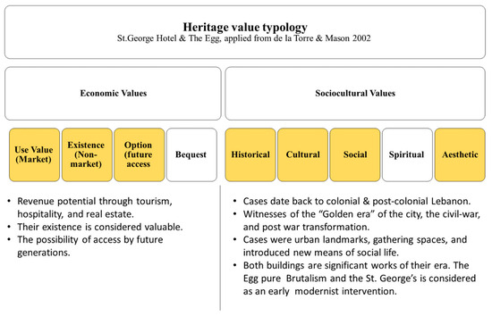
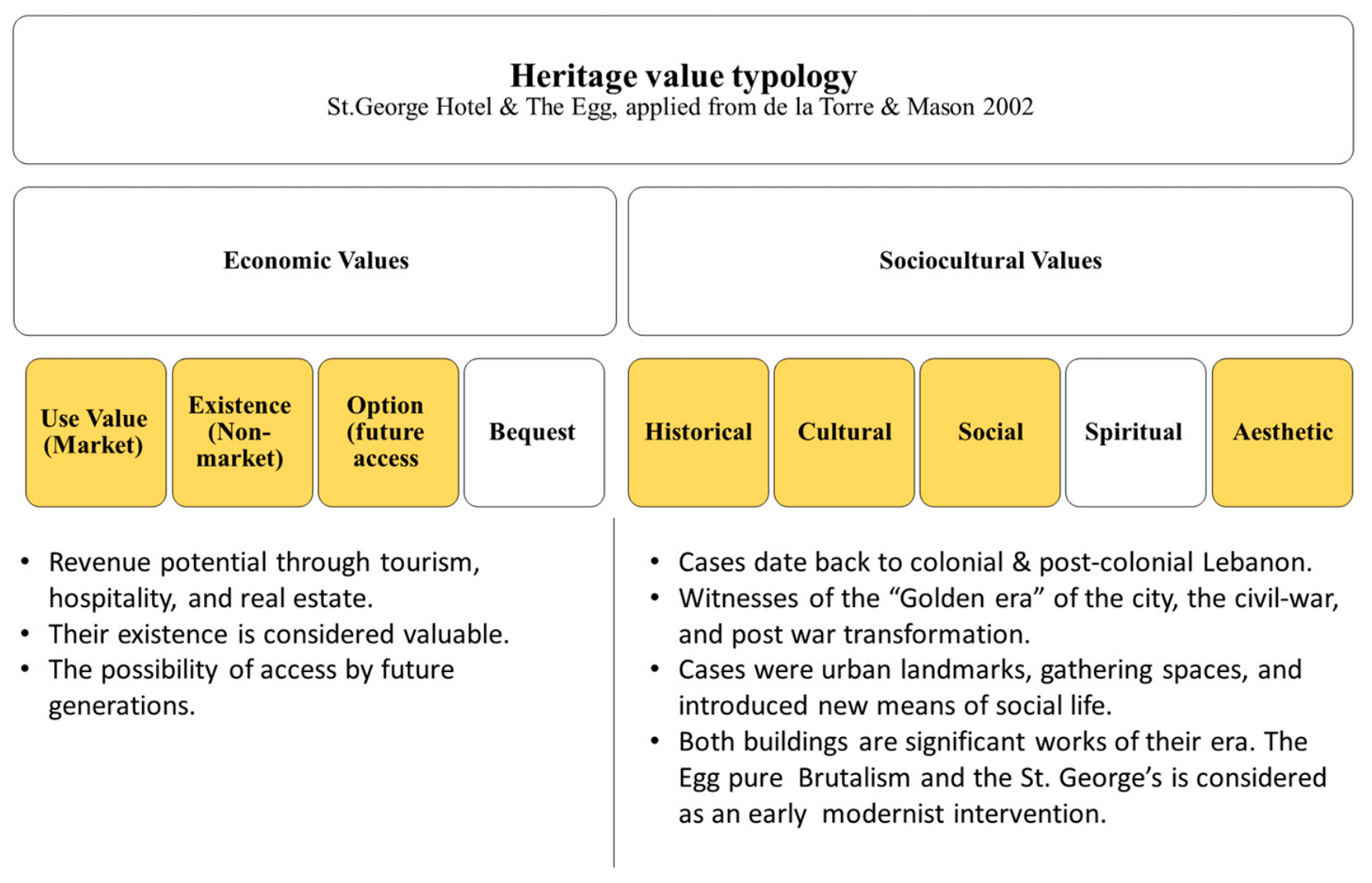
Under this framework, UNESCO, ICOMOS, and DOCOMOMO consider the product of design professions, such as works of architecture, town planning, and landscape monumental heritage, to have exceptional cultural value. Also, the Getty Institute provides an assessment of the values of cultural heritage, i.e., the Socio-cultural Values, which include the historical, social, religious, or/and the aesthetic value, and the Economic Values, which are basically the value of its existence and use value (Figure 10). Here, it is also applicable to mention the environmental value of conservation and re-use in capturing the embodied energy used [36].
Figure 10.
Heritage-value typology criteria applied to the case studies, based on de la Torre and Mason’s report Assessing the Values of Cultural Heritage [36], the Getty Conservation Institute, Los Angeles. Values applicable to the case studies are highlighted in yellow (Image source: author’s original diagram based on the de la Torre and Mason report).
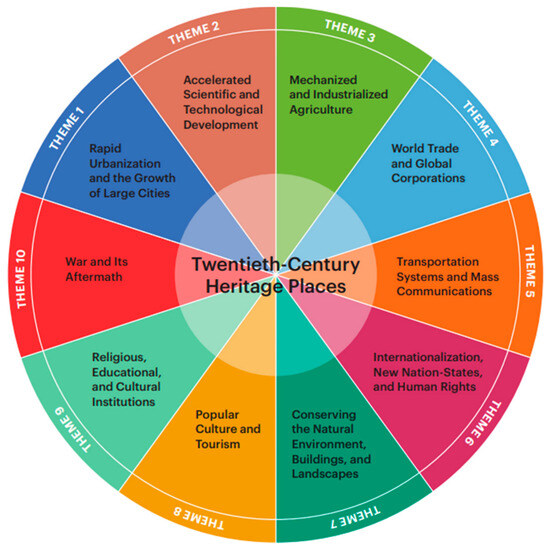
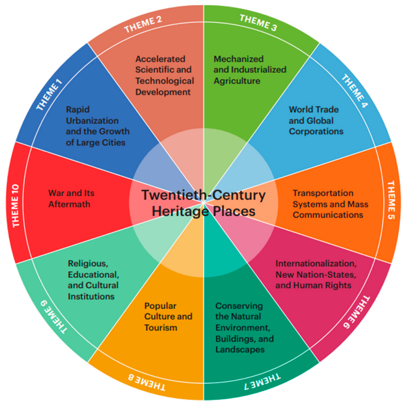
Moreover, the Getty Conservation Institute, in collaboration with the ICOMOS Twentieth-Century Heritage International Scientific Committee, provided a thematic tool for assessing and identifying Twentieth-Century Heritage Places (Figure 11). Although the ten-theme assessment is an international framework, it can be employed in contextual cases where the modernist movement differs from Western timeframes [37]. The Getty Conservation Institute underlines the definition of modern heritage as “key social, technological, political, environmental, and economic drivers of change that shaped the world from 1900 to 2000” [37].
Figure 11.
The ten interconnected themes that shaped the built environment and heritage places of the 20th century, as detailed in The Twentieth-Century Historic Thematic Framework: A Tool for Assessing Heritage Places (Image source: Susan Marsden and Peter Spearritt [37], CC BY-NC-ND 4.0).
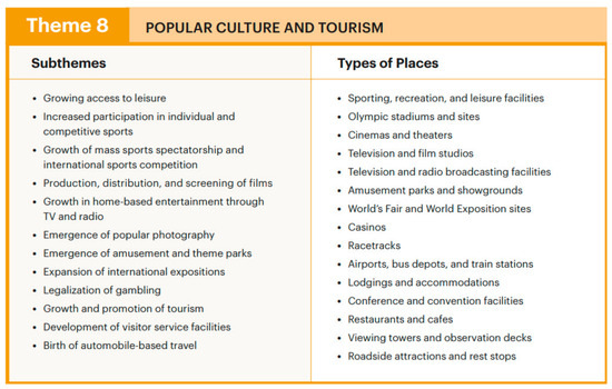
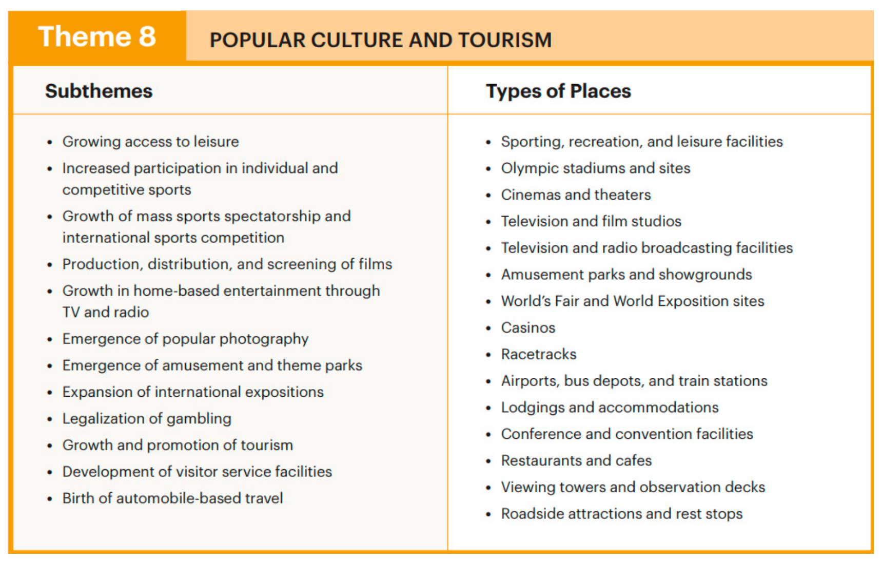
By evaluating the ten themes and de la torre and Mason [36] in the context of Beirut, the case studies are chosen based on their contribution to the socio-cultural values, including the urban value and spatial value, and the economic values. The spatial value tackles the historical and aesthetic aspects of the structure, while the urban value refers to the building’s relationship with its surroundings [37]. The cases correspond mostly to Theme 8 (Popular Culture and Tourism), following Marsden & Spearritt’s thematic framework [38], illustrating a type, a period, or a construction method, but they need several interventions to rehabilitate or maintain. Theme 8 (Figure 12) focuses on the cultural shift towards consumption and recreation through works of leisure, entertainment, and travel that occurred during the 20th-century. It covers buildings and landscapes that advocate modern lifestyles and international exchange, including hotels and cinemas.
Figure 12.
Theme 8, as illustrated in The Twentieth-Century Historic Thematic Framework. (Image source: Susan Marsden and Peter Spearritt [37]).
In 2017, a new law by the Ministry of Culture was drafted addressing a more holistic approach to heritage that was missed in the antiquities law. “The law aims to protect, revive, and showcase archaeological or historical sites, structures, landmarks, buildings, and components thereof with heritage or historical value, including built and unbuilt properties, that individually or collectively form an urban or heritage fabric in cities, villages, and towns. These properties have artistic, historical, architectural, scientific, heritage, natural, environmental, or cultural value due to their architectural character, coherence, or integration into their natural or urban surroundings”. Both case studies share a distinct historical and cultural value and would fall under the protection of this law. Nevertheless, the Lebanese Parliament has not yet adopted this law. Amid the current state of political instability, modern heritage in Beirut continues to be threatened [38].
1.3.5. Beirut’s Modern Built Heritage
The campaign to save cultural heritage sites in Beirut and Lebanon in general faces severe challenges. Although legislation and lists of historical landmarks exist, they either only protect buildings constructed before the 1700s or are not enforced due to a lack of interest and funding [30]. Therefore, existing laws exclude a rich layer of modern heritage integral to the heritage of Beirut; no legislation mentions modern-era or intangible heritage. As a result, heritage building classification and protection are based on improvised decisions that can be subject to legal appeals [39].
For instance, the DGA, which is the only institute authorized to deal with culturally significant monuments in the country, has a total of five professional archeologists with nearly nonexistent funding. This is a city where 13 different layers of history contribute to its spatial landscape and monuments spanning 5000 years. Since the 1990s, the number of listed heritage buildings in Lebanon on the “General Inventory of Historic Monuments” has fallen to almost half, from 1016 to 521 today, of which 350 are at risk, only 75 in Beirut [34,35,36,37,38,39].
Along with that, Beirut is compounded by a struggle with the lack of adequate infrastructure due to the diminishing governance of the state [32]. For example, most of the city’s supply comes from diesel generators placed in the basements or on the rooftops of buildings. Surveys showed that there is, on average, one diesel generator per two buildings in Beirut [33]. In addition, socio-political instability keeps the city in a constant state of reconstruction. In 2020, Beirut woke up to a blast that damaged around 40% of its buildings. Among them were historically significant structures dating back to the 19th century [34]. The century-long, non-adaptive, rigid urban policies have made it increasingly difficult to achieve sustainable development and address future climate scenarios, including intensified droughts, heatwaves, and energy shortages [28].
2. Materials and Methods
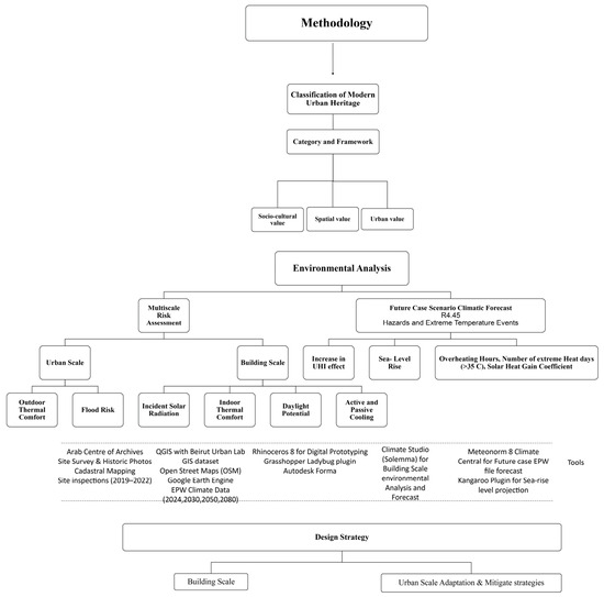
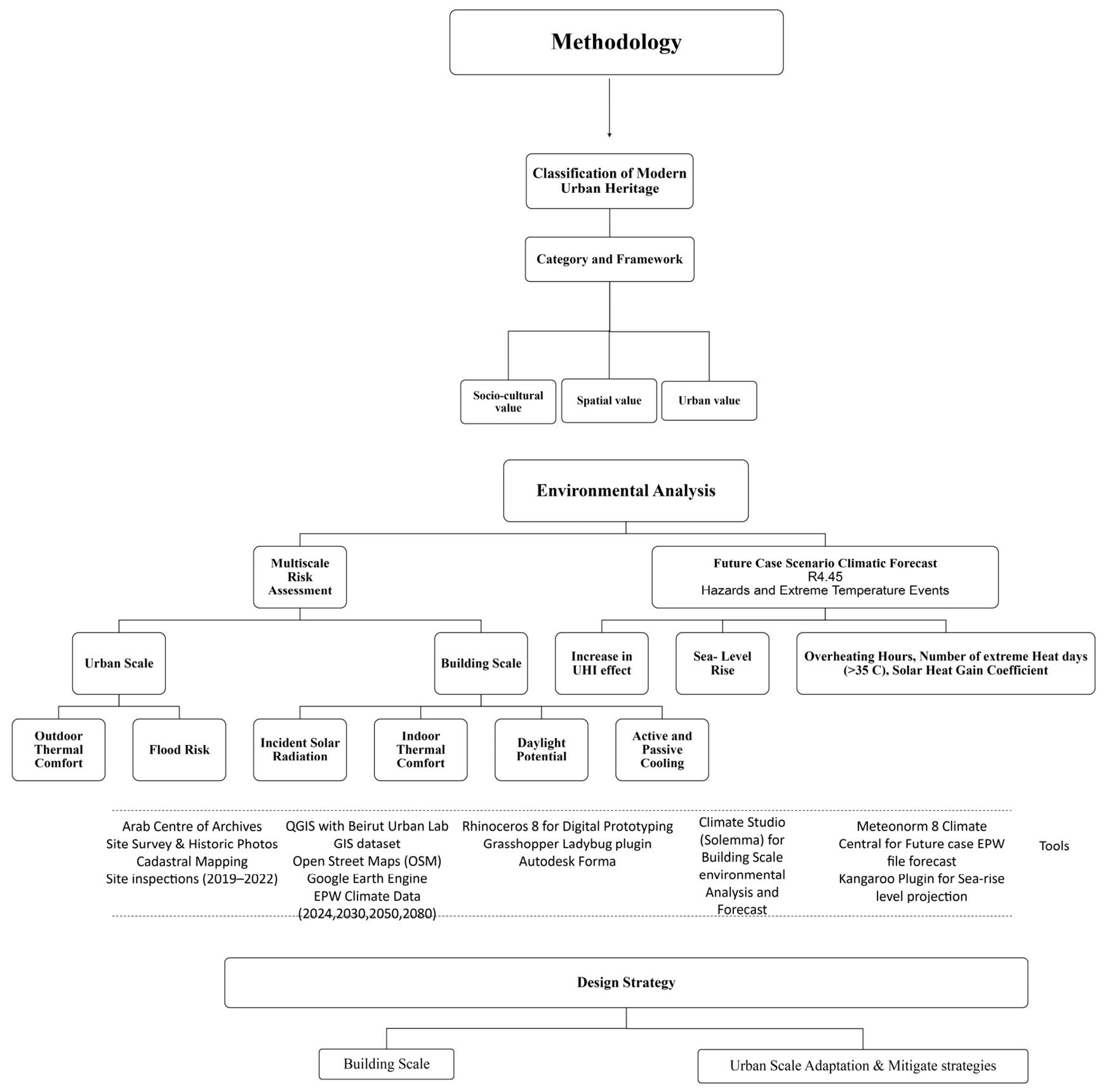
In the absence of effective legislation to classify and preserve culturally notable buildings, the city is regularly losing parts of its spatial narrative, especially its 20th-century buildings. Moreover, Beirut is experiencing extreme challenges to mitigate and adapt to future climate change scenarios. Therefore, the study adopts an approach to comprehensively address the intersection between modern urban heritage rehabilitation and the capability of these buildings to adapt to and mitigate climatic risk. (Figure 13).
Figure 13.
Methodological Approach.
First, a theoretical framework is established to categorize the selected cases as part of Beirut’s modern built heritage by analyzing the critical relationship of these monuments with the city, mainly from the works of Robert Saliba, Saree Makdisi, Assem Salam and others. Second, the study identifies the evolution, present functional and climatic performance, and the adaptability potential of the cases through a multi-scalar environmental analysis, from a district scale to a building scale, of the current condition and future scenario forecast.
2.1. Digital Prototyping and Environmental Analysis
Digital prototyping of both cases relied on three primary sources: (1) the Beirut Built Environment Database (Beirut Urban Lab, AUB, and CNRS) [40], which provides detailed geospatial data of Beirut; (2) historical imagery and archival data from the Arab Center for Architecture Archives (ACA) [15], OpenStreetMap, and Google Earth Engine; (3) site inspections conducted between 2019 and 2022. All drawings and imagery found were used to construct detailed, geo-referenced 3D models of both case studies and the CBD using Rhinoceros 3D (version 8) (Table 1).
Table 1.
Environmental analysis and simulations performed on an urban scale.
2.1.1. Meteonorm Software for Future Climate Files
To gather climatic data, EnergyPlus Weather (EPW) files, site-specific to Beirut, were obtained from Ladybug tools vers 1.5.0 and Meteonorm software vers. 8.0 was utilized to provide weather forecast files for the years 2030, 2050, and 2090 following Representative Concentration Pathway (RCP) 4.5. RCP 4.5 is a moderate scenario where climatic impacts from global emissions start to decrease by 2050 and stabilize by 2100, assuming the immediate enforcement of sustainable climate policies. EPW files were then inserted into a Grasshopper Ladybug tool and Climate Studio vers 2.3 to eventually visualize and compare the results of several Key Performance Indicators (KPIs) like incident solar radiation (kWh/m2), thermal comfort, number of hot days (>35 °C), flood risk mapping, daylight, and passive ventilation potential, both for the district and building scale levels. Ladybug can visualize thorough climate data through interactive graphs and spatial mapping (Table 1).
2.1.2. Environmental Analysis
To perform a multi-scalar environmental analysis, the Autodesk Forma (https://app.autodeskforma.com/app-home) (v2024) platform, Climate Studio plugin, and Grasshopper Ladybug plugin were chosen. Autodesk Forma provided a useful insight for urban-scale simulations, including sun hour analysis, wind speed and flow, comfort study, and microclimate analysis that combines thermal, wind, and shade information to visualize areas of optimal comfort within the urban context, considering building orientation and shadow cast by the surrounding context. However, future-scenario EPW files cannot be imported into Autodesk. Therefore, only current data were used [Table 1].
On a micro-scale, current and future projections of EPW files were imported to Climate Studio to compare the facades, roof, and ground plane with higher resolution of details. Climate Studio enables the assessment of indoor space, direct and indirect daylight availability, direct and indirect solar radiation, and glare study. In addition, Velux Daylight Visualizer was used to accurately calculate daylight levels (Table 2).
Table 2.
Environmental analysis and simulations performed on the building scale.
These outputs were compared with psychrometric charts of the key years generated by Climate Studio.
2.1.3. Analysis of Sea Level Rise
Simultaneously, future sea-level rise (SLR) projections using RCP 4.5 were collected from several sources, including the World Climate Research Program, the Coastal Risk Screening Tool developed by Climate Central, which embeds IPCC data and uses up-to-date techniques for coastal risk modeling, and Lebanon’s climate factsheet published by the Red Cross. Then the projections were simulated and visualized using the Grasshopper Kangaroo plugin (Table 2).
The key findings serve three objectives. First, to outline a framework that emphasizes the cultural significance of the focus case studies within Beirut’s modern built heritage. Second, identifying the imminent threats and opportunities facing the current status quo and the potential of reintegrating the structures into their urban surroundings. Finally, transforming climatic projections and empirical data into applicable information to provide data-driven design solutions to facilitate utility and equip the structures to adapt to and mitigate future climatic threats.
3. Results
This section discusses the key findings of the climatic inquiry, starting from the district scale to a case-specific risk assessment, and formulates a site-climate-responsive design strategy on the urban and building scale.
3.1. Climatic Risk
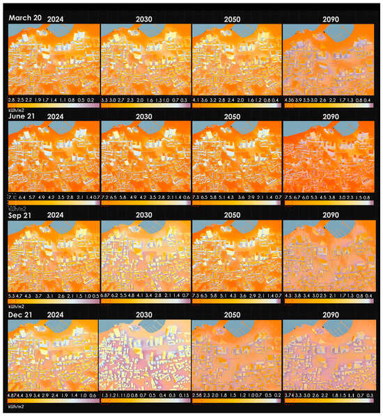
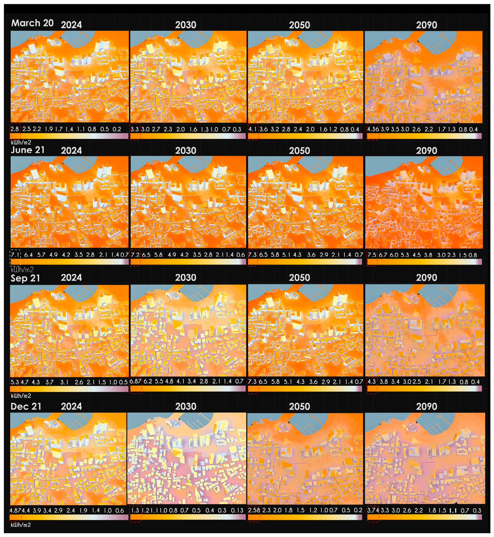
From an environmental perspective, mean temperatures in Beirut have risen by +3.8 °C from 1979 to 2025. In the same period, precipitation has decreased by about 3 mm [6]. This trend is expected to worsen. Under RCP 4.5, the number of hot days (>35 °C) may increase by 40–60 days per year by 2080. The mean temperature could rise by +3 °C by 2080. Solar radiation is expected to increase in all seasons from 2024 to 2090, with June showing the highest rise. Each period (2030, 2050, 2090) shows increased solar radiation in the downtown area, worsening the UHI effect. On 21 June, the highest incident radiation will occur, rising to 7.5 kWh/m2 by 2090 from 7.1 kWh/m2 now. The city will experience hotter, longer, and more frequent heat extremes. The psychrometric chart forecast shows a shift towards warmer, more humid conditions by 2090, with humidity ratios above 0.025 kg water/kg air (Figure 14). This reduces the number of hours in both indoor and outdoor thermal comfort zones, increasing the chance of extreme heat and making passive comfort strategies harder to maintain.
Figure 14.
Radiation analysis and forecast of Beirut’s CBD area for 21 June, 20 March, 21 September, and 21 December. Within each panel, four heatmaps correspond to the years 2024, 2030, 2050, and 2090. The color gradient indicates varying intensity values across the urban area and visible water bodies; the color bars below each set show the scale of the represented values. The figure illustrates changes in incident radiation over time and across seasons. In red dashed box the maximum incident radiation during the day (Image source: author’s original drawing).
3.2. Case Study I—The Saint George Hotel & Bay
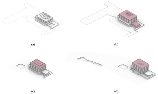
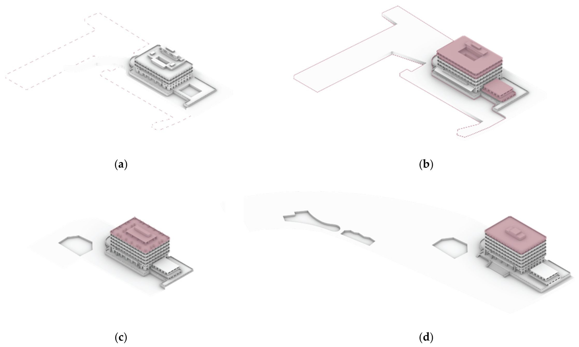
The original design of the building exhibited an approach to contextualize modernist ideas to the local climate. The original structure (1929) featured passive shading and cooling features to reach thermal comfort. For example, the hotel was organized around a central open-air atrium, and the upper parts of doors and windows were treated to ensure optimal daylight and passive natural ventilation and to reduce direct sun exposure. Moreover, a wind-tower-like structure was placed on the roof to facilitate natural ventilation, along with perforated breeze walls on the ground and mezzanine levels. Also, the focus on horizontality enabled 1.5 m cantilevers to protect the facade from heat influx, while perforations in the guardrail maximized wind flow. Results show that these features were heavily disrupted after a series of expansions, renovations, and damage during the civil war and the explosion of 2005. During the 1960s the building nearly doubled in size with two additional floors to accommodate more rooms and after the war an additional floor was added (Figure 15).
Figure 15.
The St. George Hotel & Bay evolution from 1929 to 2025: (a) original design (1929); (b) 1960s expansion; (c) post-2005 explosion; and (d) current status. Dashed lines mark future land use (Image source: author’s original image using Rhinoceros 8).
Since the 1990s, the Saint George Hotel has been a powerful symbol of resilience against demolition. Hariri’s plan scheduled it for demolition. However, the second-generation owner of the land, Fady Khoury, opposed the new vision and resisted Solidere for more than 30 years. Since the acquisition of the CBD by Solidere, the area has been reserved for multi-millionaire real estate developments and seasonal tourism, pushing most of Beirut’s residents away from its historic center.
Multi-Scale Assessment and Design Strategy
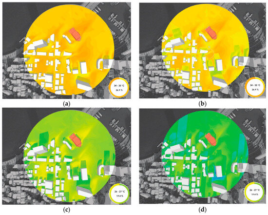
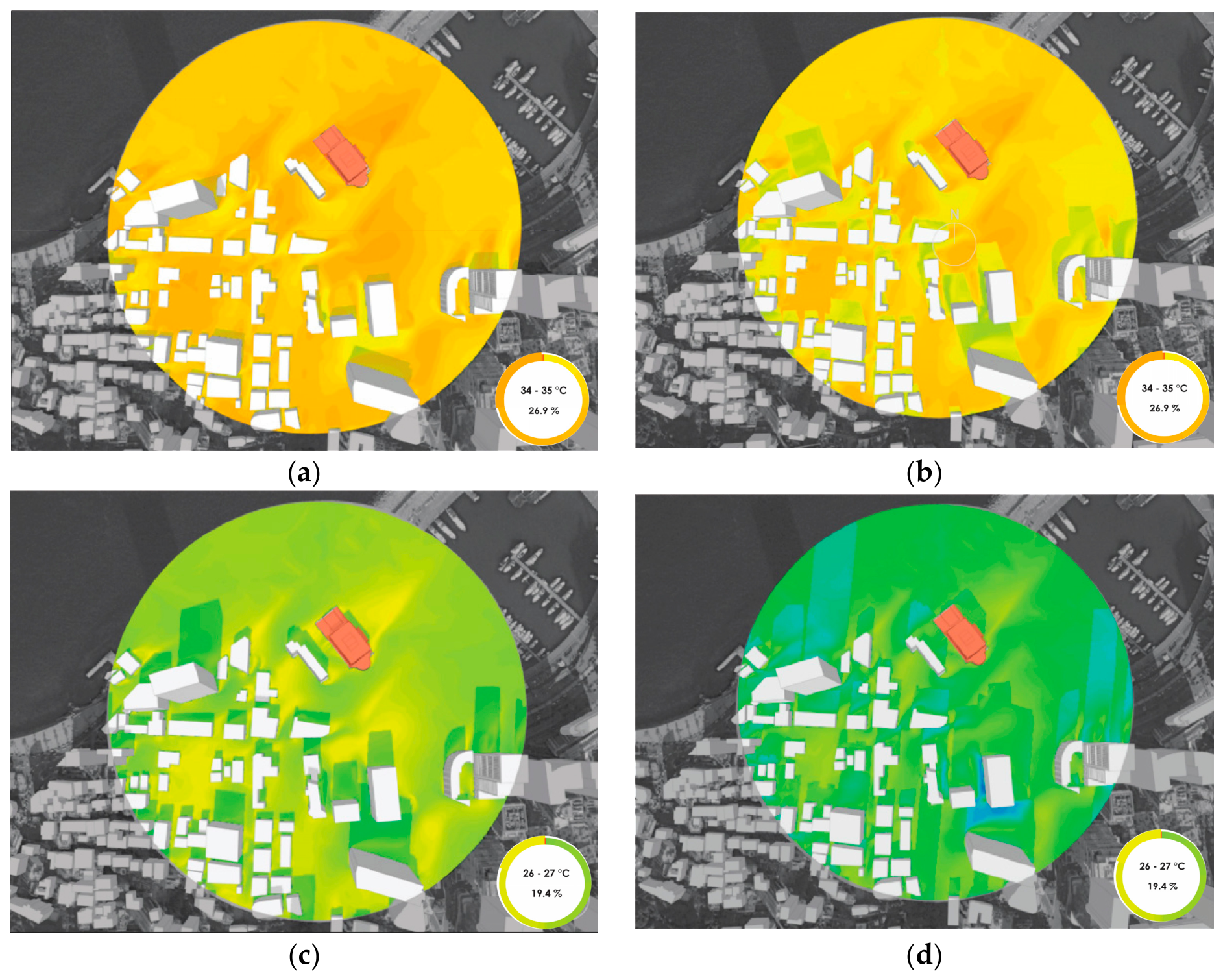
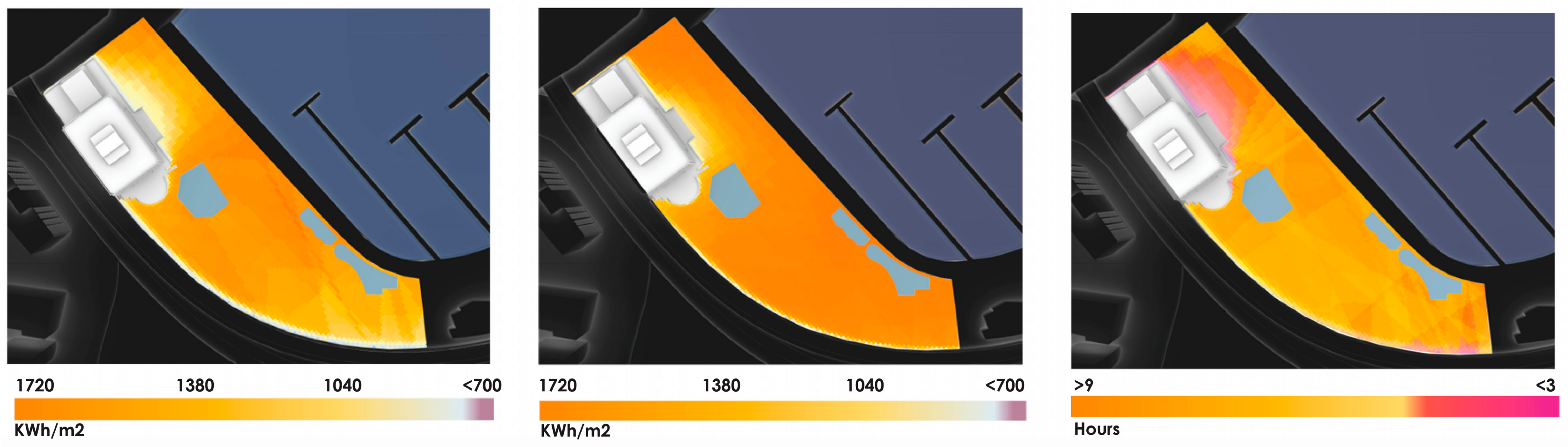
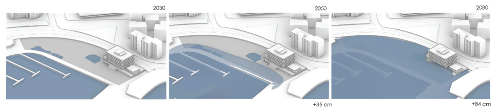
Today, the site contains the building, the Hotel, and adjacent land, historically the bay. The hotel itself remains uninhabited, and the landscape is occupied for private recreational use. Microclimate studies on the site using Autodesk Forma show peak temperatures near 40 °C during summer (21 June) (Figure 16), and surface solar radiation conducted using the Ladybug Incident Solar Radiation Analysis component exceeds 1500 kWh/m2 during the warm periods due to the lack of adequate blue and green infrastructure (Figure 17). All results were visualized directly on the 3D model through a color map. Using moderate projections from the IPCC’s Sixth Assessment Report (AR6) and Climate Central’s Coastal Risk Screening Tool, sea level rise (SLR) scenarios for the site are expected to increase by +35 cm and +85 cm by 2050 and 2090, respectively (Figure 18).
Figure 16.
Microclimate analysis of the study area conducted using Autodesk Forma showing thermal comfort indices (UTCI). (a) June 21 shows strong heat stress in the range of 34–35 °C on 72% of hours; (b) September 21 shows strong heat stress in the range of 34–35 °C on 74% of hours; (c) March 20 shows temperatures between 25 and 27 °C 9.3% of hours; (d) December 21 shows temperatures between 22 and 23 °C 2.3% of hours. In red is the St.Geroge Hotel and in white is the surrounding context buildings. (Image source: author’s original image using Autodesk Forma).
Figure 17.
Incident solar radiation and sun hour analysis of the Saint George Hotel site, Beirut. (left) Cumulative incident solar radiation during the cold period (kWh/m2); (middle) cumulative incident solar radiation during the warm period (kWh/m2); (right) sun hours on 21 June (summer solstice). Color scale ranges from orange (high exposure: ≥1720 kWh/m2 and >9 h) to pink-white (low exposure: <700 kWh/m2 and <3 h). (Image source: author’s original drawing using Beirut Urban Lab GIS data and the Ladybug tool).
Figure 18.
Sea level rise simulation for Saint George Hotel & Bay, illustrating projected sea level rise over time. The first image, labeled 2030, shows minimal water coverage beyond the current shoreline. The second image, labeled 2050, depicts increased water coverage flooding parts of the harbor and adjacent land, with a noted rise of +35 cm. The third image, labeled 2080, shows extensive flooding covering most of the harbor and surrounding areas, with a rise of +84 cm. The images highlight the progressive impact of sea level rise on the urban waterfront. (Image source: author’s original image).
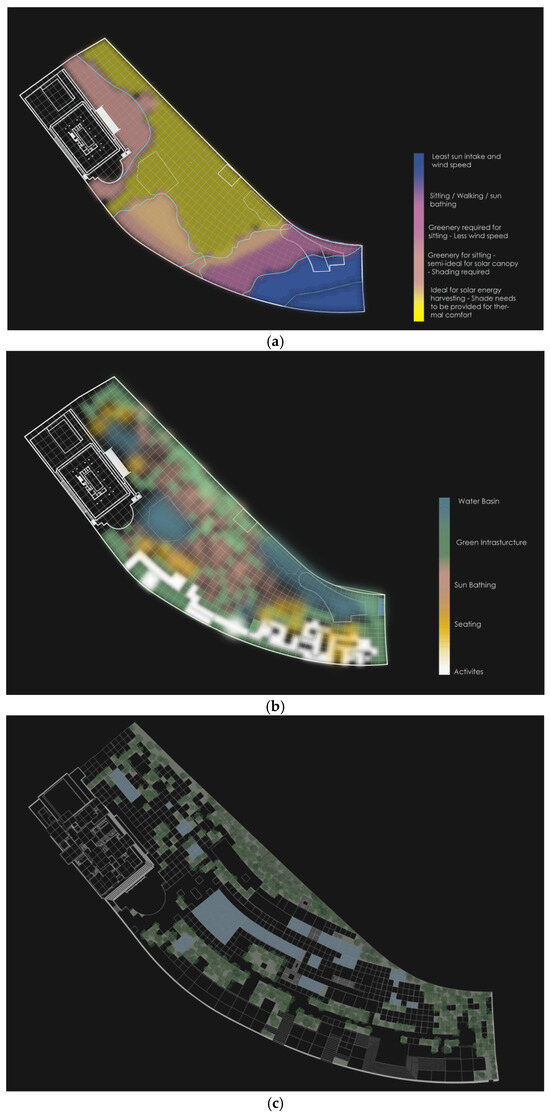
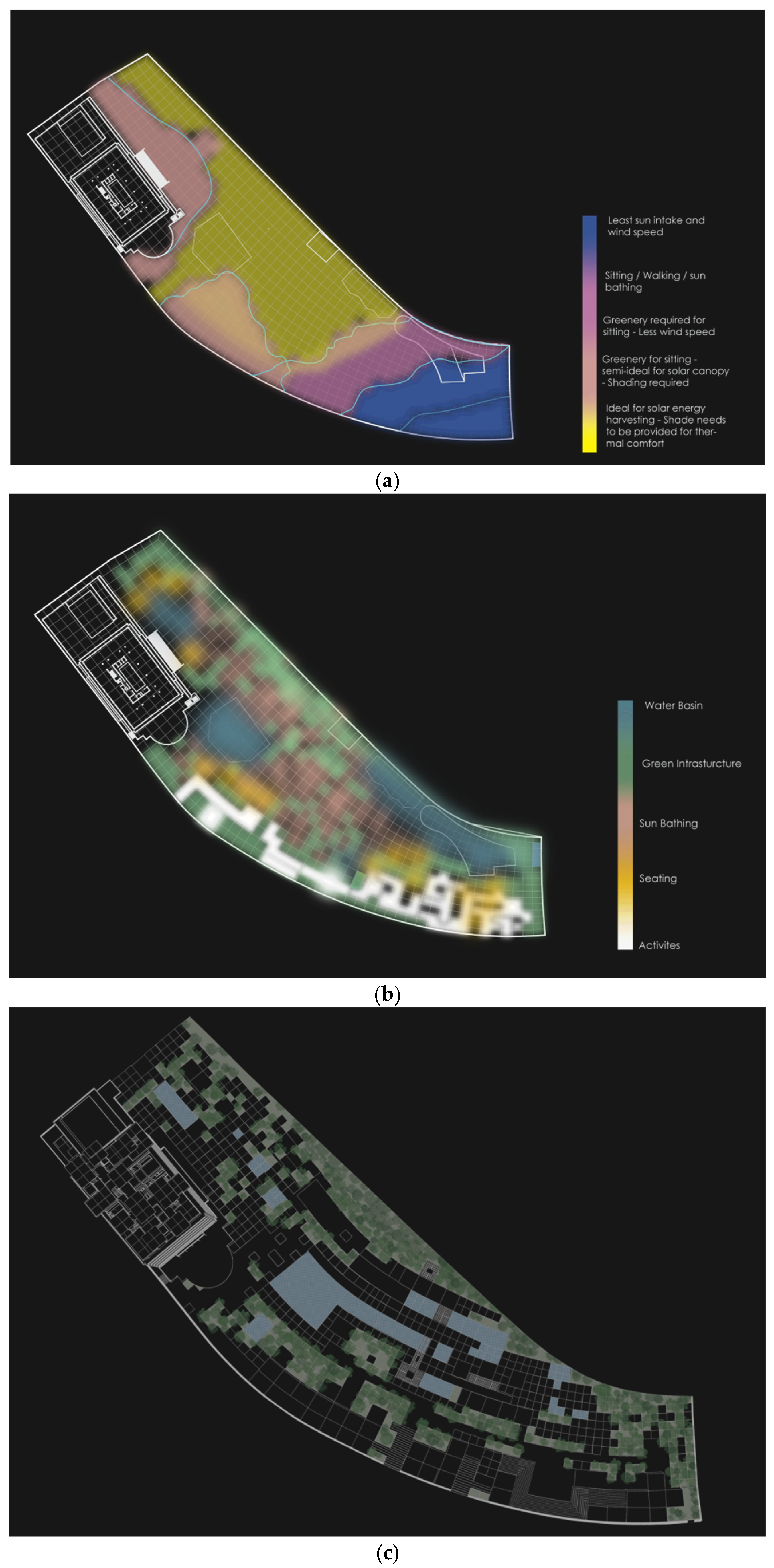
This will cause the basement floor to be partially flooded in the future. Data were visualized using Rhinoceros 3D vers. 8 and Grasshopper vers. 1 using a high-resolution 3D model for the Saint George Hotel and Bay coastline. Furthermore, decades of inactivity isolated the site from its connection to the city and the sea. The intervention aimed to address the relationship between preserving the urban and cultural value while simultaneously rehabilitating the existing status quo to mitigate, adapt, and benefit from upcoming climatic risks. Additionally, to revitalize the connection between the waterfront, the city, and the site as an activated public space (Figure 19).
Figure 19.
(a) Proposed spatial distribution; (b) spatial zoning for optimal outdoor thermal comfort; (c) proposed green and blue infrastructure, In green is the proposed green areas and in blue is the proposed water features. (Image source: author’s original).
Therefore, actions involved considering Nature-Based Solutions (NBS) to transform the coastal public space and the basement floor into a floodable park that carefully zones rain gardens and water pools in high-radiation areas to enhance evaporative cooling and safeguard against sea level rise. Also, a permeable landscape planted with coastal native, drought-tolerant, and endangered species, including Juniperus drupacea, Quercus calliprinos, Thymus libanotius, Crataegus azarolus, Cyclamen libanoticum, and Alkanna Maleolens Bornm., would help reduce water consumption, combat biodiversity loss, and create shade.
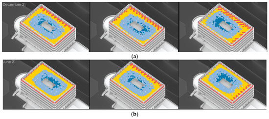
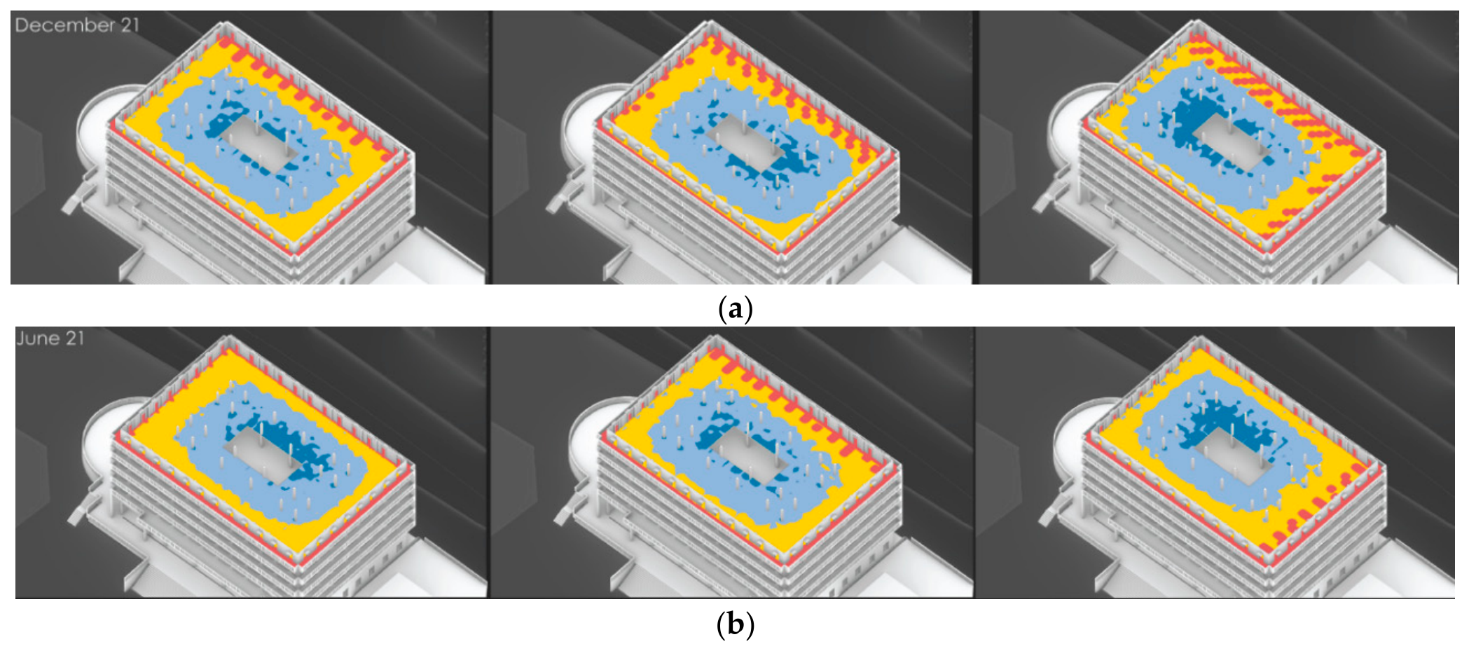
At the building scale, enhancing the environmental performance is a priority as the structure lacks any sort of indoor thermal comfort and has a daylight illuminance deficiency of around 300–400 lux in indoor spaces. Also, multiple renovations led to changes in layout, materiality, and climatic responsiveness that decreased the quality of natural passive cooling and heating (Figure 20).
Figure 20.
(a) December 21 daylight hours range approximately >9 h; blue zones indicate significant daylight deficiency, while red-yellow concentrations persist along south-facing balcony overhangs. (b) On June 21, with approximately >10 daylight hours available, yellow coverage expands markedly; however, blue zones persist in the inner courtyard recesses. (Image source: author’s original drawing using Climate Studio tool).
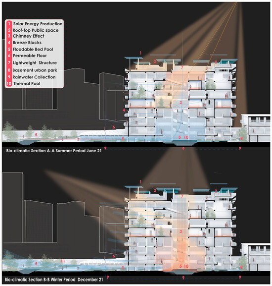
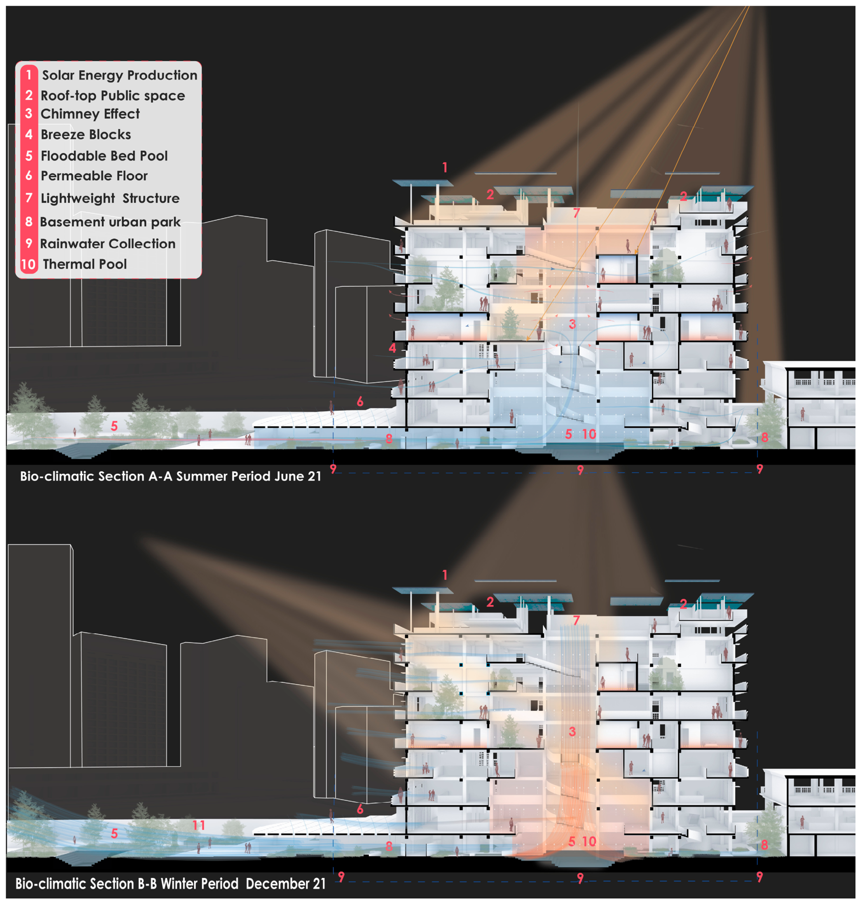
Consequently, the required interventions include the provision of adequate insulation, natural ventilation, and indirect natural sunlight. The intervention focuses on two primary objectives: firstly, restoring the passive cooling mechanisms of the original design. Secondly, extracting principles from the indigenous vernacular architecture about materials, spatial organization, and climatic adaptability. A central atrium, reinstated from the basement throughout all levels, generates a chimney effect and supports passive natural ventilation throughout the building. The floodable pool located in the basement facilitates the cooling of hot air in summer and, in combination with the atrium, enables enough airflow from the basement to the roof, enhancing indoor air quality and thermal comfort. (Figure 19 and Figure 21).
Figure 21.
Bio-climatic perspective section diagrams of the proposed intervention during the 21 June summer period and 21 December winter period. (Image source: author’s original image).
3.3. Case Study II—Beirut City Center “The Egg”
The current state of The Egg remains solely composed of the structure itself, the first, second, and third floor platforms, and the five underground platforms. A void is visible in the middle, from the ground floor until the second floor below ground, indicating the previous location of the demolished building connected to The Egg structure. The structure of the building consists of reinforced concrete columns that support the platforms and the structure. The research is based on a preliminary environmental comparative analysis, using Autodesk Forma, between the current state of the building and the original design by the architect, which was never completed, to understand the microclimatic performance of The Egg structure and the void, in these two scenarios, as a design trajectory assessment. The considered parameters were solar hours, wind dynamics, shading patterns, and perceived temperature, all of which contribute to outdoor thermal comfort.
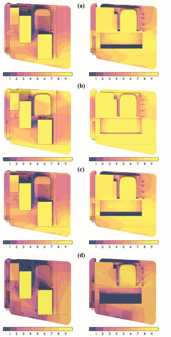
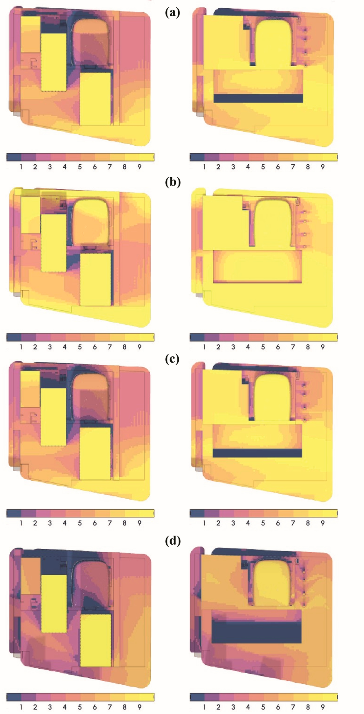
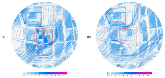
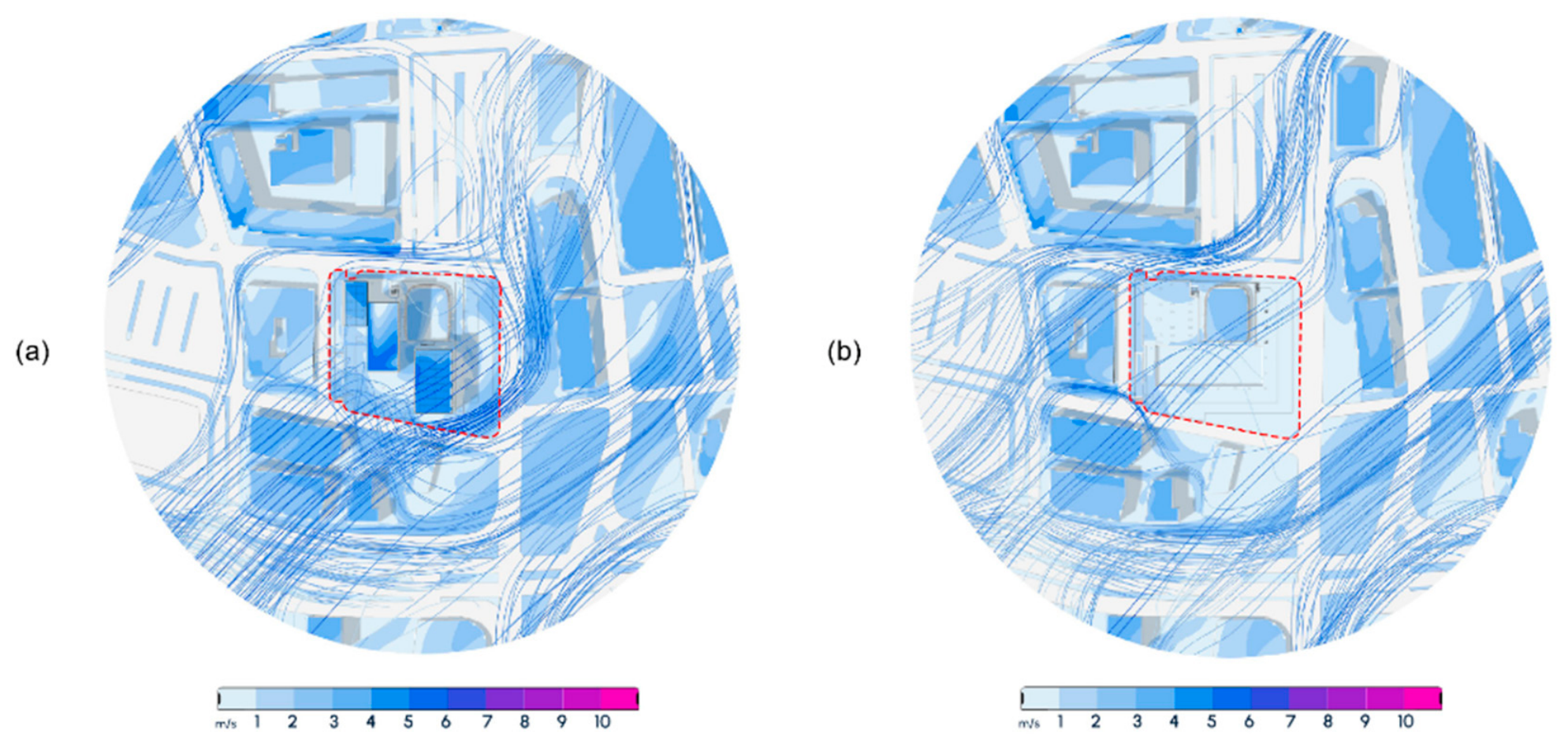
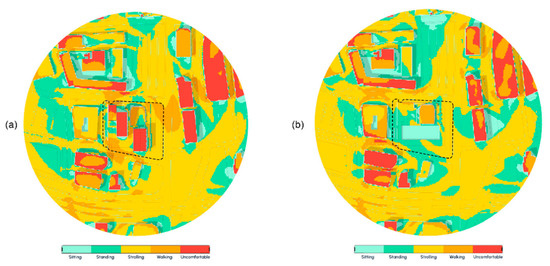
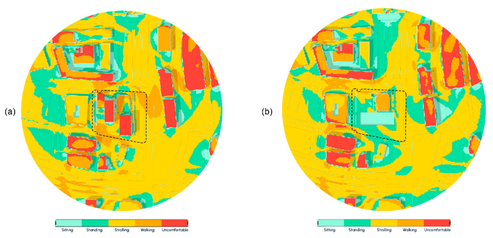
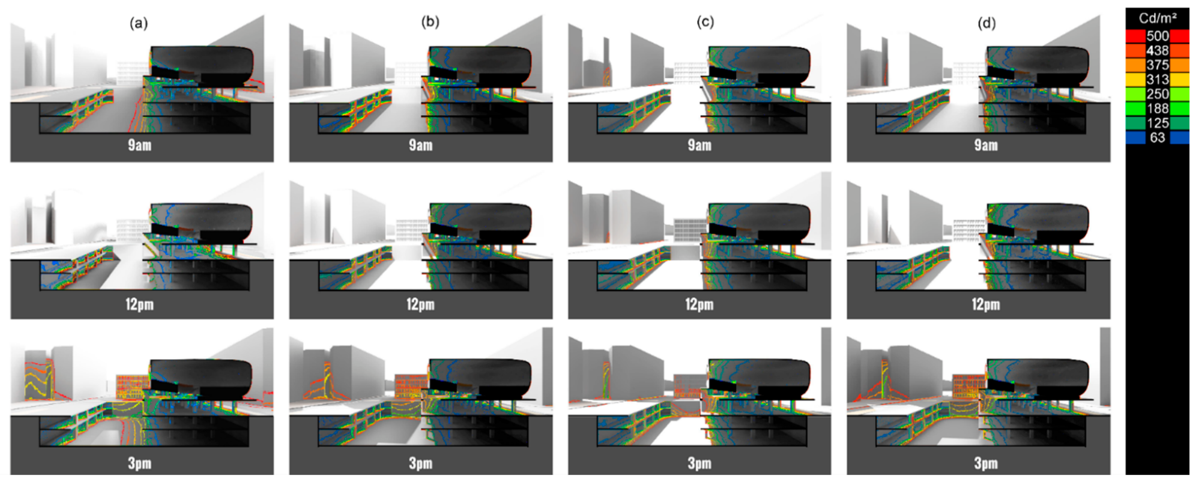
The results show that the site receives a larger average daily amount of sun hours (9 h) throughout the year under its current state, in contrast with Karam’s design (5 h), which limits sun exposure (Figure 22) and wind direction (Figure 23) due to the presence of the towers around The Egg. This analysis showcased the effect of the towers on the thermal comfort (Figure 24) on the platforms and confirmed the necessity to minimize the heights of any additions to The Egg’s surroundings. In addition, the analysis examined the current solar incident radiation’s effect on multiple levels of The Egg and its platforms as well as the future projections in relation to temperatures in the years 2050 and 2080 (Figure 25); it shows rising temperatures, an increase in levels of humidity, and a decrease in comfort zones.
Figure 22.
(a) March 20; (b) June 21; (c) September 21; (d) December 21. Comparison of sun hours analysis between the original design by Joseph Karam and the current state of The Egg. (Image source: author’s original drawing conducted with Autodesk Forma).
Figure 23.
(a) Original design; (b) existing condition analysis of wind patterns using flow lines that illustrate wind direction. Site borders are in red dashed color. (Image source: author’s original drawing conducted with Autodesk Forma).
Figure 24.
(a) Original design; (b) existing condition analysis of thermal comfort that evaluates how temperature, sunlight, wind, and humidity affect how comfortable outdoor spaces feel, classified across activity levels such as sitting, standing, strolling, and walking, and identifies uncomfortable areas. Site borders are in black dashed color. (Image source: author’s original drawing conducted with Autodesk Forma).
Figure 25.
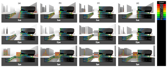
(a) December 21; (b) March 20; (c) June 21; (d) September 21, analysis of luminance levels, measured in cd/m2 on The Egg and the platforms, measured in cd/m2 (candela per square meter). The analysis shows that it is very unlikely for the sunlight to penetrate the inner spaces of the basements and The Egg, during most days of the year. Therefore, it allows us to understand the importance of relying on voids to allow sunlight to reach further interior spaces. (Image source: author’s original drawing conducted with Velux Daylight Visualizer).
Using the analysis as a basis for a design proposal, Nature-Based Solutions (NBS) have been implemented to ameliorate the environmental performance of The Egg. The process involves modifying the surrounding platforms (concrete floor slabs, walls, and vertical circulation elements) so that the alterations support The Egg structure in terms of environmental performance and circulation. The result is a living machine that functions and adapts to the climatic conditions while serving visitor comfort.
The intervention draws on vernacular architecture, specifically the courtyard in traditional Lebanese houses, to provide natural cooling, lighting, and ventilation as a passive environmental system. The intervention consisted of utilizing the existing void as a key element to reinterpret the courtyard effect. A new void has been introduced to penetrate The Egg, creating a chimney effect that enables vertical airflow originating from the courtyards and helps regulate temperature and air pressure across multiple levels of the building. Consequently, an opening in the southern façade of The Egg is required to facilitate air ventilation and allow a controlled amount of sunlight to enter, while limiting harsh summer exposure using shading devices applied to the openings of the void and the southern façade. To enhance natural cooling during hot weather conditions, a water pool was incorporated into the southern area of the plot. Its placement was informed by wind pattern studies, allowing airflow to work with the water surface and be directed into the courtyards across multiple levels. In this way, the pond functions as a passive cooling element, complementing the courtyard’s role in regulating temperature.
4. Discussion
Aligning with an expanding area of research focused on integrating climate action into built heritage conservation, this study on Beirut’s modernist cultural heritage aims to guide quantitative, data-driven decision-making processes beyond the intrinsic values of the sites. The research examined a detailed assessment of the city’s vulnerability to climate change and the potential of such at-risk sites to catalyze urban regeneration processes rather than silently wait for their dismissal.
The methodological approach chosen (Figure 13) aimed to address the following research areas: (i) a classification framework for assessing 20th-century modern built heritage sites in Beirut using historical inquiry and contextualized international outlines by institutions like UNESCO World Heritage Center, ICOMOS, DOCOMOMO and the Getty Conservation Institute; (ii) use site specific climatic data and future predictions to perform a multi-scalar environmental analysis to assess the current and forecasted environmental risk involved in the site’s degradation including outdoor thermal comfort, flood risk, incident solar radiation, indoor thermal comfort, daylight potential, and active/passive cooling potential; and (iii) bring climate-adaptive design into the earliest stage of the preservation decision making process, especially in 20th-century buildings that have fallen into disrepair, to position environmental data as an argument for a site/socio-cultural responsive rehabilitation process rather than an energy optimization tool to be unconnectedly implemented.
The findings are consistent with broader international frameworks to combat the implications of urbanization on climate change and to conserve 20th-century culturally notable buildings. From an environmental perspective, the IPCC report (AR6) mentions the importance of reusing existing buildings as part of climate mitigation strategies to reduce material use and avoid further emissions brought by new construction [2]. However, according to the ICOMOS Climate Change and Cultural Heritage Working Group report, even though these remarks were made, the connection to the significance of cultural heritage regeneration to climate change is still not highly visible at the global scale in the climate sciences field [41]. The report also highlights that the conservation practice needs a methodological shift to position heritage as a climate-action asset against the consequences of climate change, like climatic migration, flooding, or desertification. Moreover, the report suggests incorporating this intersection into all levels of governance and policy [41].
On the other hand, UNESCO’s HUL approach, DOCOMOMO approach, and the Getty Conservation Institute frameworks [34,36] demonstrated its utility beyond the Western temporal framing for classifying Twentieth-Century Heritage Places applied in the context of Beirut. Nevertheless, documented actions on 20th-century buildings using these frameworks, illustrated by Croft and Macdonald in the Getty Conservation Institute’s “Concrete: Case Studies in Conservation Practice” [42], show that the conservation practice, from funding decisions to intervention strategies, usually prioritizes material or values-based preservation methodologies rather than framing 20th-century concrete buildings’ preservation as a climate-action asset [42]. Also, even though DOCOMOMO’s framework was updated in 2014 to explicitly promote adaptive reuse as a primary safeguard against demolition and to preserve the embodied energy [43], it still does not specify climate risk data (current or projected) as an input into the conservation-prioritization stage. This demonstrates the misalignment of the climate science field and its relation to viewing 20th-century modern heritage as climate assets and vice versa.
4.1. Discussion on the Saint George Hotel & Bay
The findings for The Saint George Hotel reinforce growing global concern about climate-change-induced sea-level rise in coastal areas, as experts recognize that coastal infrastructure globally is vulnerable to rising sea levels, intensified storm surges, and increased flooding. Moreover, classifying the building’s spatial, urban, and socio-cultural value as a novel architectural work from the pre-independence period worthy of preservation and rehabilitation using CADe could reposition unlisted 20th-century works as drivers of climate-resilient urban regeneration practices in other fragile Mediterranean contexts. Reintegrating the site into its surroundings as a public space and the application of NBS and flood-resistant interventions show effectiveness in contributing to the city’s climatic and social resilience.
4.2. Discussion on Beirut City Center “The Egg”
The results showcase the potential to re-use existing brutalist buildings as a sustainable and functional project, using NBS, and to change the public narrative around their harsh and cold appearance, by showcasing their true architectural and cultural potential and bringing new life to the urban context. Assessing this potential before dismantling part of a local and global architectural movement is environmentally, culturally, and economically responsible. In the case of The Egg, its survival positions architecture as part of a narrative that extends beyond its materiality and makes its demolition a threat to the collective public notion of persistence.
4.3. Policy Recommendations and Future Outlook
Current regulations and legislative frameworks have not been effective in conserving Beirut’s spatial narrative from aggressive real estate development due to the lack of will to enforce new legislative drafts. Also, because of socio-political instability and the deterioration of state governance, very few initiatives account for future climate risks in urban areas, especially coastal cities. Co-investment in the preservation and adaptive reuse of cultural heritage assets as climate infrastructure needs to be addressed through cooperation among the state, international and national institutions, and NGOs.
Since major urbanization trends also occurred in most EMME region cities during similar timeframes, especially in the Levant, future research should integrate a data-driven environmental risk assessment into 20th-century modernist built heritage regeneration and extend it to a broader inventory of unlisted modernist buildings in Lebanon and across coastal cities of the EMME region. Furthermore, future research will aim to integrate cross-disciplinary collaboration between architecture, data science, and urban sociology to study the socio-economic implications of such approaches.
4.4. Limitations
While this approach provides an essential perspective linking climatic performance and CADe to urban heritage conservation, it is essential to acknowledge restrictions and limitations, such as the reliance on limited climate models and emission scenarios that may include some inaccuracies. For instance, the environmental simulations follow only RCP 4.5, a moderate emissions scenario. Results from a more severe scenario, like RCP 8.5, were not part of the testing. Therefore, this underestimates risk exposure under a business-as-usual trajectory.
Moreover, although climate models and projections offer valuable insight into site-specific conditions, they may not consider all microclimatic conditions. Another limitation is the modeling approach’s reliance on multiple data sources to create close approximations rather than accurate digital prototyping using photogrammetry technologies. Lastly, post-occupancy performance validation is not possible at this stage; the proposed design strategies remain projective rather than empirically verified. Implementation would require collaboration with structural engineers and conservation specialists. Future research should conduct a full lifecycle carbon assessment to compare the embodied carbon of preservation versus new construction. Future research should empirically assess via simulations the implications of such changes to the building’s thermal and structural performance, and the case selection pool and criteria should extend to the Greater Beirut area and other coastal cities in Lebanon to incorporate different typologies and socio-political contexts.
5. Conclusions
Using Beirut as a case study of fragile Mediterranean cities that face pressing climatic risks and cultural heritage degradation, the study aimed to explore modernist built heritage preservation processes as an act of climatic adaptation rather than as an extra layer of complexity to the conservation process. The study highlights that embracing CADe during the early stages of the design process can inform a more comprehensive heritage preservation strategy. Moreover, employing digital tools like Grasshopper Ladybug Tools, Autodesk Forma, and Climate Studio, along with climate data processing tools like Meteonorm, in conducting a multi-scalar environmental analysis enabled a site-specific preview of the current and future climatic risk of the selected case studies, namely, the St. George Hotel & Bay and the Beirut City Center “The Egg”. While the research is context-specific to Beirut, the methodological framework developed is applicable to other vulnerable modernist structures across coastal Mediterranean cities of the region.
Significant findings from this study are presented below.
In the St. George Hotel, building evolution analysis reveals that the building lost most of its originally incorporated passive cooling strategies through recurrent partial destruction, expansion, or restoration. Therefore, restoring and enhancing its original passive performance features to face future climatic change scenarios offers a more resilient pathway to conservation practices in the city. Also, it challenges the argument that 20th-century buildings are inherently climatically unresponsive. The integration of digital environmental simulation tools into the early design stages informed the decision-making process beyond the political or cultural arguments to a more quantifiable environmental rationale.
For Beirut City Center, the proposal aimed to revalue the structure into a case of heritage-led regeneration of public space. Future climate projections under RCP 4.5 predict increased solar radiation, rising mean temperatures, and high humidity levels that will decrease the thermal comfort thresholds during summer. The proposed design intervention does not attempt to restore the original vision. Rather, it aimed to advise an active adaptive reuse approach while also introducing climatically adaptive measures that increase the outdoor thermal comfort threshold. However, under the current status quo without any legal or financial incentives to protect the structure, demolition threats are still active and highly probable.
Author Contributions
Conceptualization, K.M., M.A. and A.F.; Methodology, K.M. and A.F.; Software, A.F.; Validation, A.F.; Formal analysis, K.M. and M.A.; Investigation, K.M. and M.A.; Resources, K.M. and A.F.; Writing—original draft, K.M.; Writing—review and editing, A.F.; Visualization, K.M. and M.A.; Supervision, A.F.; Project administration, A.F. All authors have read and agreed to the published version of the manuscript.
Funding
This research received no external funding.
Institutional Review Board Statement
Not applicable.
Informed Consent Statement
Not applicable.
Data Availability Statement
The original contributions presented in the study are included in the article; further inquiries can be directed to the corresponding author.
Conflicts of Interest
The authors declare no conflicts of interest.
References
- Lazoglou, G.; Papadopoulos-Zachos, A.; Georgiades, P.; Zittis, G.; Velikou, K.; Manios, E.M.; Anagnostopoulou, C. Identification of Climate Change Hotspots in the Mediterranean. Sci. Rep. 2024, 14, 29817. [Google Scholar] [CrossRef] [Scilit] [PubMed]
- IPCC. Climate Change 2023: Synthesis Report. Contribution of Working Groups I, II and III to the Sixth Assessment Report of the Intergovernmental Panel on Climate Change; Lee, H., Romero, J., Eds.; IPCC: Geneva, Switzerland, 2023. [Google Scholar]
- Gerard, J.; Zaarour, R.; Saliba, N.; Traboulsi, M.; Gérard, P.-C.; Bakhache, C.; Kehdy, N.; Ess, F. Beirut Faced with Climatic Aridification. Sci. Chang. Planét. Sécher. 2013, 24, 214–223. [Google Scholar] [CrossRef] [Scilit]
- Mahmoud, M. The Future of Climate Change Mitigation in the Middle East and North Africa; Middle East Institute: Washington, DC, USA, 2023. [Google Scholar]
- Miller, K.A.; Zittis, G.; Santillo, D.; Johnston, P.A. Living on the Edge: The Implications of Climate Change for Six Countries in the Middle East North Africa Region; Greenpeace Research Laboratories Technical Report 02-2022; Greenpeace Research Laboratories: Exeter, UK, 2022. [Google Scholar]
- Lebanon—Projections. Climate Change Knowledge Portal; World Bank Group: Washington, DC, USA.
- Ministry of Environment (MOE); United Nations Development Programme (UNDP). Climate Change: Vulnerability and Adaptation; United Nations Development Programme: Beirut, Lebanon, 2011. [Google Scholar]
- Red Cross Red Crescent Climate Centre (RCCC). Country Profiles: Lebanon: Climate Factsheet Summarizing Climate Conditions, Changes, and Impacts. Available online: https://www.climatecentre.org/wp-content/uploads/RCCC-Country-profiles-Lebanon_2022-Final.pdf (accessed on 2 February 2026).
- Verdeil, É. Infrastructure Crises in Beirut and the Struggle to (Not) Reform the Lebanese State. Arab Stud. J. 2018, 26, 84–113. [Google Scholar]
- UN-Habitat Lebanon. Beirut City Profile 2021; UN-Habitat Lebanon: Beirut, Lebanon, 2021.
- Lebanon Demographics. Available online: https://www.worldometers.info/demographics/lebanon-demographics/ (accessed on 23 March 2026).
- Kaloustian, N.; Bitar, H.; Diab, Y. Urban Heat Island and Urban Planning in Beirut. Procedia Eng. 2016, 169, 72–79. [Google Scholar] [CrossRef] [Scilit]
- Ghadban, M.; Baayoun, A.; Lakkis, I.; Najem, S.; Saliba, N.A.; Shihadeh, A. A Novel Method to Improve Temperature Forecast in Data-Scarce Urban Environments with Application to the Urban Heat Island in Beirut. Urban Clim. 2020, 33, 100648. [Google Scholar] [CrossRef] [Scilit]
- Malterre-Barthes, C. A Moratorium on New Construction; Critical Spatial Practice Series; Sternberg Press: Berlin, Germany, 2025. [Google Scholar]
- Arab Center for Architecture. Hôtel Saint-Georges (1). Available online: https://arab-architecture.org/db/building/hotel-saint-georges-1 (accessed on 6 January 2026).
- Khoury, M.P. The Egg: Memory and Visual Structures Within Representations of an Iconic Lebanese Ruin. Vis. Commun. Q. 2017, 24, 3–14. [CrossRef] [Scilit]
- Hindi, N. Converging Space and Memory at Beirut’s New Waterfront Public Space. In Proceedings of the Organising Committee at the Faculty of Architecture, Art and Design (FAAD); Notre Dame University Louaize: Zouk Mosbeh, Lebanon; p. 281.
- Boano, C.; Chabarek, D. A Stroll down Memory Lane—The Battle of the Hotels. J. Space Syntax 2013, 4, 130–135. [Google Scholar]
- Onceinawhile. National Museum of Beirut – St Georges Hotel Beirut. Wikimedia Commons. 2019. Available online: https://commons.wikimedia.org/wiki/File:National_Museum_of_Beirut_–_St_Georges_Hotel_Beirut.jpg (accessed on 7 May 2026).
- van de Poll, W. The Mediterranean Coast and the Hotel St. Georges in the City of Beirut. Van de Poll Photo Collection, National Archives, Beirut, Lebanon, 1950. Available online: https://www.nationaalarchief.nl/onderzoeken/fotocollectie/aee49d6c-d0b4-102d-bcf8-003048976d84 (accessed on 19 April 2026).
- Corbo, S. The Scars of the City: Beirut’s Egg as Spatial and Political Amplifier. Le Visit. 2022, 27, 136–140. [Google Scholar] [CrossRef] [Scilit]
- Traboulsi, F. A History of Modern Lebanon, 2nd ed.; Pluto Press: London, UK, 2012. [Google Scholar]
- Saliba, R. Deconstructing Beirut’s Reconstruction: 1990–2000 Coming to Terms with the Colonial Heritage; Darat Al-Funun: Amman, Jordan, 2000. [Google Scholar]
- El Hayek, C. The Last Levantine City: Beirut, 1830–1930. Ph.D. Thesis, Massachusetts Institute of Technology, Cambridge, MA, USA, 2015. [Google Scholar]
- Hindi, N. Urban Forms at the Intersection of Imperialism and Colonialism: A Perspective on Beirut. In Proceedings of the International Planning History Society (IPHS); Notre Dame University: Zouk Mosbeh, Lebanon, 2018. [Google Scholar]
- Saliba, R. Historicizing Early Modernity—Decolonizing Heritage: Conservation Design Strategies in Postwar Beirut. Tradit. Dwell. Settl. Rev. 2013, 25, 7–24. [Google Scholar] [CrossRef] [Scilit]
- Abdelsalam, T. Reshaping the City Image: Impact of the French Colonial Architecture on the Contemporary Identity of Beirut Central District. Int. J. Innov. Res. Dev. 2013, 2, 13. [Google Scholar]
- Haddad, E.G. Learning from Beirut: From Modernism to Contemporary Architecture. Enq. ARCC J. Archit. Res. 2008, 5, 45–52. [Google Scholar] [CrossRef] [Scilit]
- Rabbat, N. The Levantine Age: Cosmopolitanism and Colonialism in the Eastern Mediterranean. In Being Urban, 1st ed.; Routledge: London, UK, 2020; p. 14. [Google Scholar]
- Verdeil, E. Michel Ecochard in Lebanon and Syria (1956–1968). The Spread of Modernism, the Building of the Independent States and the Rise of Local Professionals of Planning. Plan. Perspect. 2012, 27, 249–266. [CrossRef] [Scilit]
- Rafferty, M. Relational Urbanisation, Resilience, Revolution: Beirut as a Relational City? Urban Plan. 2022, 7, 183–192. [Google Scholar] [CrossRef] [Scilit]
- Nasr, J.; Verdeil, É. The Reconstructions of Beirut. In The City in the Islamic World; Jayyusi, S.K., Holod, R., Petruccioli, A., Raymond, A., Eds.; Brill: Leiden, The Netherlands, 2008; pp. 1116–1141. [Google Scholar] [CrossRef] [Scilit]
- Ahmed, N. Is the Concept of ‘Resilience’ Useful within Cities Facing both Conflict & Disaster Risk? Using Beirut as a Case Study; Humanitarian Academy for Development: Birmingham, UK, 2016. [Google Scholar]
- Makhzoumi, J.; Al-Harithy, H.; Bazzi, M. Contextualizing UNESCO’s Historic Urban Landscape Approach: A Framework for Identifying Modern Heritage in Post-Blast Beirut. Land 2024, 13, 2241. [Google Scholar] [CrossRef] [Scilit]
- UNESCO World Heritage Centre. Recommendation on the Historic Urban Landscape (HUL): Resources. Available online: https://whc.unesco.org/en/hul/#resources (accessed on 19 June 2026).
- de la Torre, M. (Ed.) Assessing the Values of Cultural Heritage: Research Report; The Getty Conservation Institute: Los Angeles, CA, USA, 2002. [Google Scholar]
- Marsden, S.; Spearritt, P. The Twentieth-Century Historic Thematic Framework: A Tool for Assessing Heritage Places; with contributions from Schmidt, L., Burke, S., Ostergren, G., Cody, J., and McCoy, C.; Getty Conservation Institute: Los Angeles, CA, USA, 2021. [Google Scholar]
- Bou Aoun, C. Himayat Al-Abniya Al-Turathiya Fi Intithar Al-Kanoun (1): Al-Abniya Al-Mujammad Hadmouha fi Beirut Traja’at min 1016 ila 485 fa 209. Legal Agenda, 2020. Available online: https://english.legal-agenda.com/reclaiming-public-space-and-its-role-in-producing-the-revolution/ (accessed on 13 March 2026).
- El-Bastawissi, I.Y.; Raslan, R.; Mohsen, H.; Zeayter, H. Conservation of Beirut’s Urban Heritage Values through the Historic Urban Landscape Approach. Urban Plan. 2022, 7, 101–115. [Google Scholar] [CrossRef] [Scilit]
- Fawaz, M.; Gharbieh, A. The Beirut Built Environment Database (BBED); Beirut Urban Lab, American University of Beirut: Beirut, Lebanon, 2025. [Google Scholar]
- ICOMOS Climate Change and Cultural Heritage Working Group. The Future of Our Pasts: Engaging Cultural Heritage in Climate Action; ICOMOS: Paris, France, 2019. [Google Scholar]
- Croft, C.; Macdonald, S.; Ostergren, G. (Eds.) Concrete: Case Studies in Conservation Practice; Getty Conservation Institute: Los Angeles, CA, USA, 2019. [Google Scholar]
- DOCOMOMO International. Eindhoven-Seoul Statement, 2014. Available online: https://docomomo.com/organization/ (accessed on 13 July 2026).

Disclaimer/Publisher’s Note: The statements, opinions and data contained in all publications are solely those of the individual author(s) and contributor(s) and not of MDPI and/or the editor(s). MDPI and/or the editor(s) disclaim responsibility for any injury to people or property resulting from any ideas, methods, instructions or products referred to in the content. |
© 2026 by the authors. Licensee MDPI, Basel, Switzerland. This article is an open access article distributed under the terms and conditions of the Creative Commons Attribution (CC BY) license.