


Abstract
Climate change and sea-level change (SLC) are intensifying flooding in U.S. coastal communities, with disproportionate impacts on Black and minority neighborhoods that face displacement, economic hardship, and heightened health risks. In Norfolk, Virginia, sea levels are projected to rise by at least 0.91 m (3 ft) by 2100, placing underserved neighborhoods such as Oakleaf Forest at particular risk. This study investigates the compounded impacts of flooding at both the building and urban scales, situating the work within the framework of the UN Sustainable Development Goals (UN SDGs). A mixed-method, community-based approach was employed, integrating literature review, field observations, and community engagement to identify flooding hotspots, document lived experiences, and determine preferences for adaptation strategies. Community participants contributed actively through mapping sessions and meetings, providing feedback on adaptation strategies to ensure that the process was collaborative, place-based, and context-specific. Preliminary findings highlight recurring flood-related vulnerabilities and the need for interventions that address both environmental and social dimensions of resilience. The study proposes multi-scale, nature-based solutions (NbS) to mitigate flooding, restore ecological functions, and enhance community capacity for adaptation. Ultimately, this work underscores the importance of coupling technical strategies with participatory processes to strengthen resilience and advance climate justice in vulnerable coastal neighborhoods.
1. Introduction
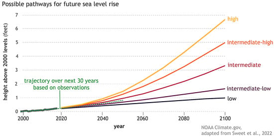
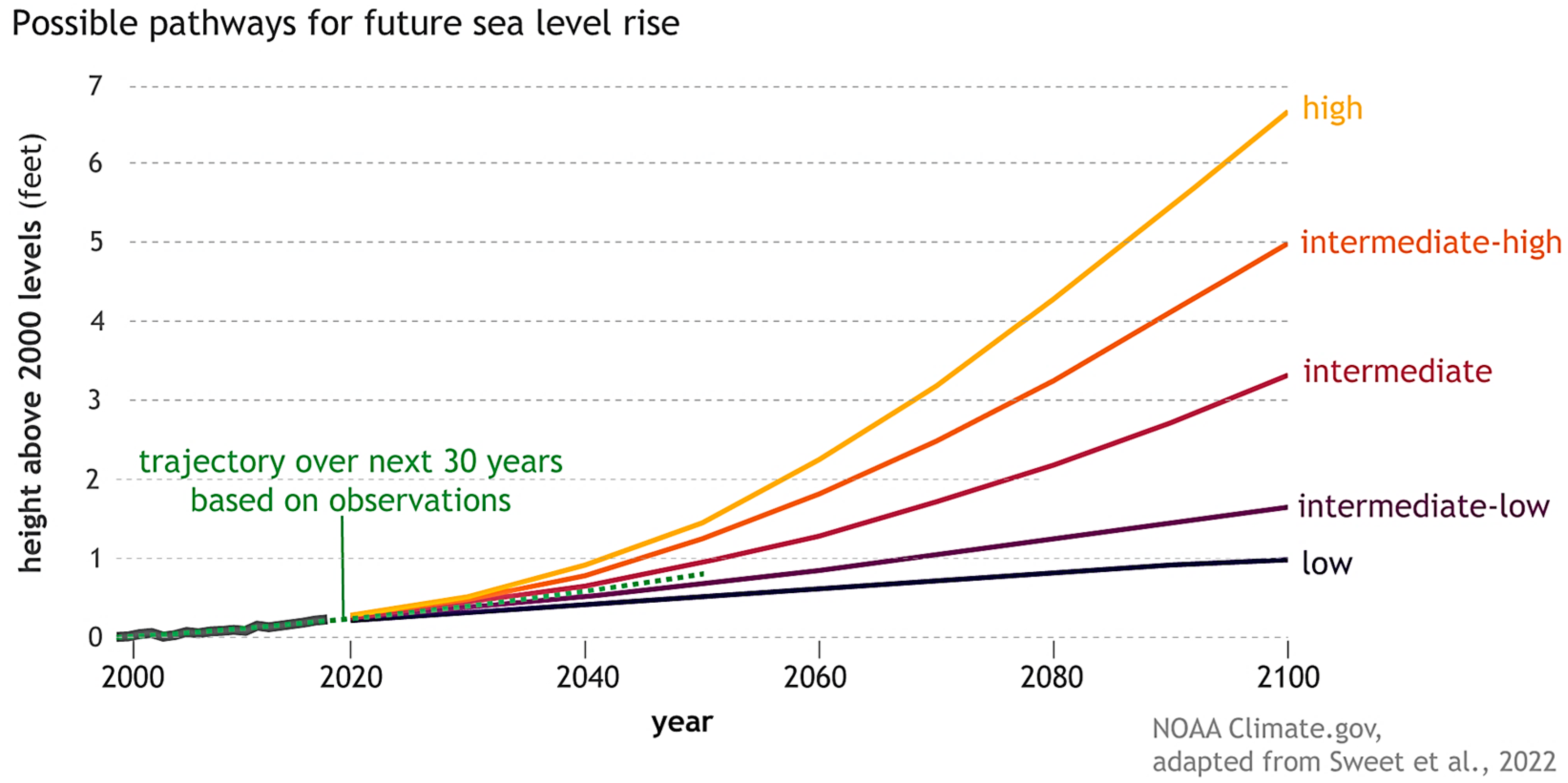
Climate change is a significant 21st -century challenge, with rising sea levels being particularly alarming and costly. After roughly 2000 years of stability, global sea levels began rising in the 20th century, with the rate accelerating in recent years. Since 1993, the average global sea level has risen by approximately 0.31 to 0.36 cm (0.12–0.14 in) per year, about twice the long-term historical rate. Overall, the global mean sea level (GMSL) has increased by roughly 16 to 21 cm (6.30–8.27 in) since 1900, with about 6 to 7 cm (2.36–2.76 in) of that have risen since 1993. Human-induced climate change has been a major driver of this trend, leading to a rate of sea-level rise greater than any observed in at least the past 2800 years [1]. As illustrated in Figure 1, global sea levels have followed a steadily rising trajectory since 2000, and projections indicate that they could increase by 0.3 to 2.1 m (0.98–6.89 ft) above year-2000 levels by 2100, depending on greenhouse gas emission scenarios and ice-sheet responses [2].
Figure 1.
Observed sea level from 2000–2018, with future sea levels through 2100 for six future pathways (colored lines). The pathways differ based on future rates of greenhouse gas emissions and global warming and differences in the plausible rates of glacier and ice sheet loss [2].
SLC is a hydrological phenomenon where geological and climatic factors combine, leading to a rapid increase in average sea levels, both locally and globally [3,4,5,6]. SLC is driven by rising global temperatures, shifting tectonic plates, and groundwater or petrochemical withdrawals, which cause land to sink while water levels permanently rise [3,4,5,6,7]. It destroys wetlands and other coastal marine habitats, and poses significant human challenges, including the loss of life, injuries, and various health impacts, alongside damage to and loss of property, infrastructure, livelihoods, service provision, and environmental resources [8].
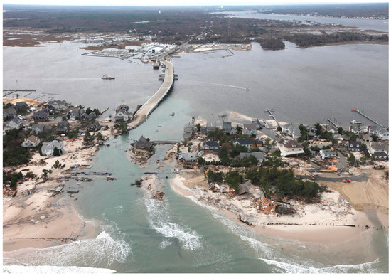
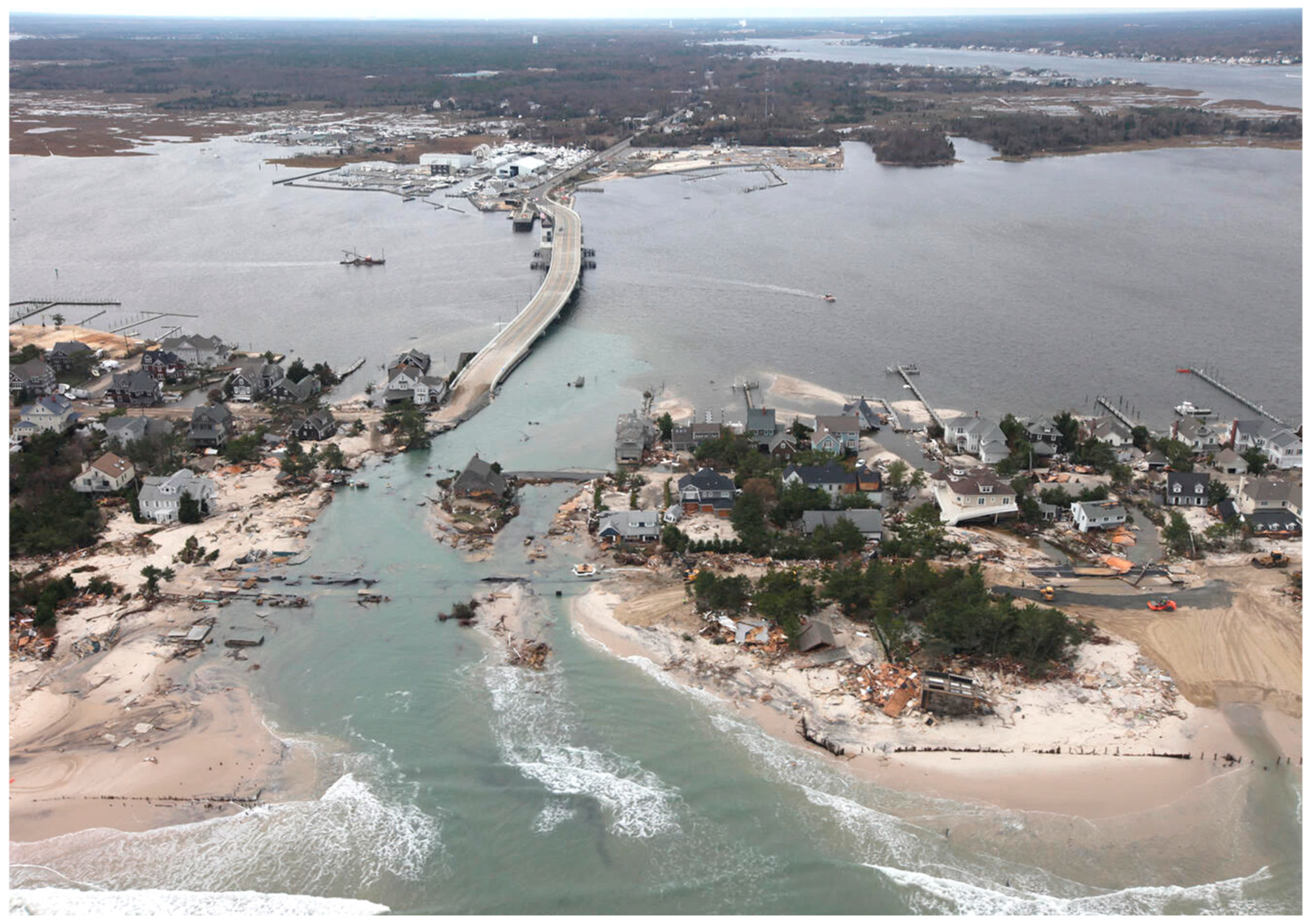
Public-health consequences of flooding span acute and chronic harms—including drowning, injuries, infectious and gastrointestinal illness from contaminated waters, mold-related and other respiratory problems, mental-health sequelae, and prolonged care interruptions—burdens that escalate with more frequent inundation events [7,8,9]. This is especially pronounced in densely populated urban areas, where reliance on transportation and energy infrastructure renders them vulnerable to flood damage. As [10] mentioned, floods rank among the most devastating climate-related risks to physical infrastructure, including roads, communication networks, buildings, and social amenities, thereby escalating maintenance and replacement costs (Figure 2).
Figure 2.
Impact of SLC on Coastal Cities: Aerial photos of the Mantoloking, New Jersey coastline in the aftermath of Hurricane Sandy, New Jersey [11].
Recent national modeling projects a 26% increase in U.S. flood risk by 2050 due to climate change alone, even without factoring in continued urban development, with damages and disruptions disproportionately concentrated in socially vulnerable areas [12]. Importantly, these risks are not born equally. Research has shown that historically redlined and under-invested Black and minority neighborhoods face systematically higher exposure to flooding and infrastructural deficiencies, reflecting the enduring legacy of discriminatory planning and investment practices across hundreds of U.S. cities [13]. These combined findings underscore how rising seas and intensifying coastal flooding are compounding environmental injustices—driving displacement, economic pressures such as housing market mispricing and insurance withdrawal, and widening health inequities for Black and other marginalized coastal communities [14].
The effects of SLC can be arrested in urban areas through implementation of policies and management programs typically termed resilience and adaptation [15,16]. These initiatives can protect communities for the foreseeable future but will need to be updated and improved over time. Careful consideration of equity concerns will be necessary to equitably manage resilience measures so as not to harm communities and vulnerable residents [17,18].
This research focuses on Southside Norfolk, near the Chesapeake Bay in Virginia, a region experiencing the highest rate of relative SLC along the U.S. East Coast. According to the National Oceanic and Atmospheric Administration (NOAA), the sea level around Sewells Point, Virginia, has risen by 35.56 cm (14 in) since 1950. Its speed of rise has accelerated over the last ten years, and it is now rising by 2.54 cm (1 in) every 4 years [4]. Scientists know this because the sea level is measured every 6 min using equipment like satellites, floating buoys off the coast, and tidal gauges to accurately measure the local sea level as it accelerates and changes.
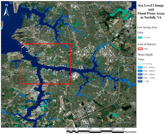
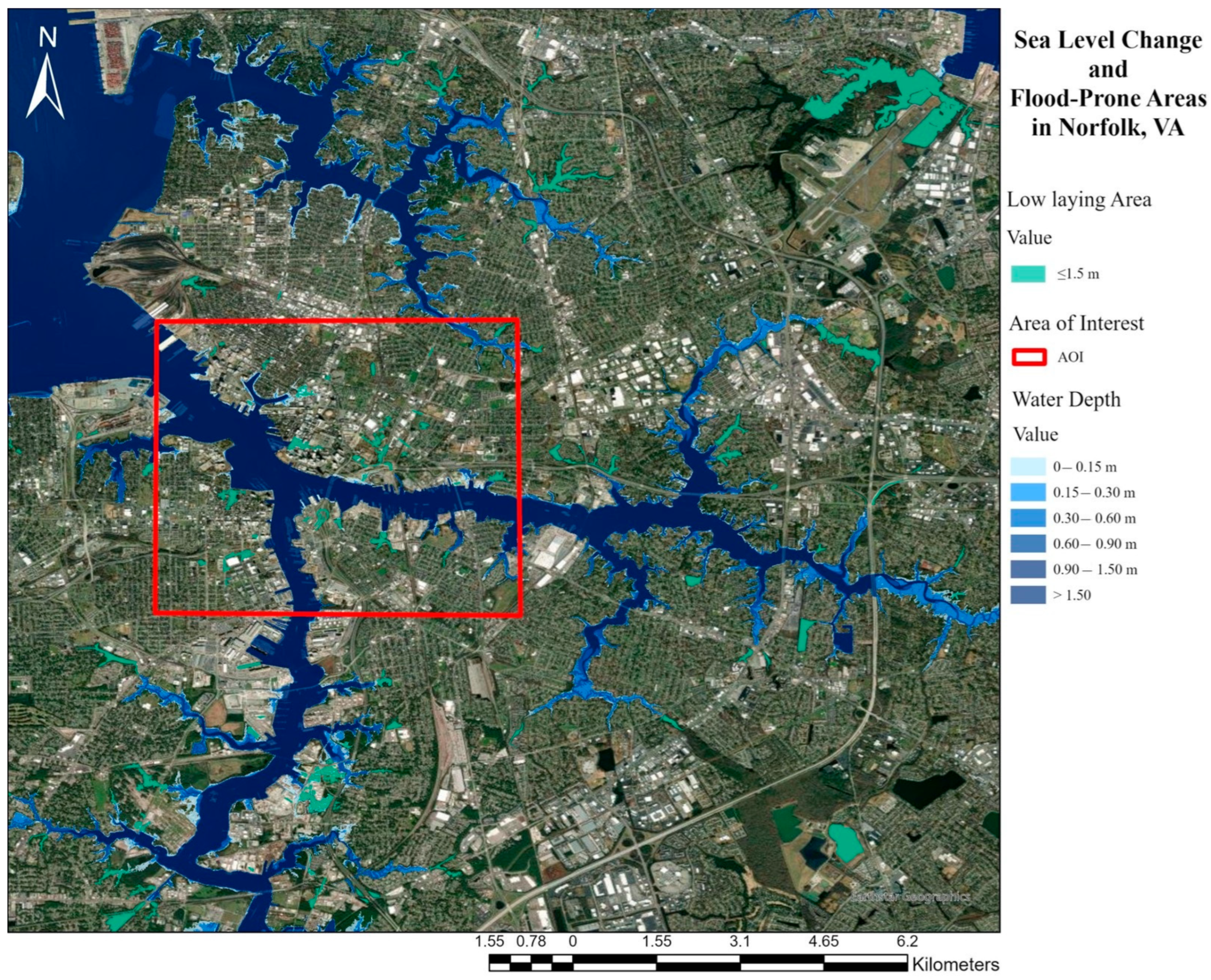
The rapid rise results from a combination of land subsidence and rising global sea levels caused by climate change. Norfolk’s location, its geological conditions, and the increased melting of Greenland ice sheets significantly contribute to this phenomenon, making the area highly vulnerable to flooding and coastal hazards. In coastal Virginia, recurrent flooding already inundates streets and homes, while frequent storms damage infrastructure and disrupt daily life. SLC is expected to exacerbate these issues, posing an even greater threat to low-lying roads, residential areas, and critical infrastructure (Figure 3).
Figure 3.
Research focus area and projected SLC in Norfolk, VA [19].
With a focus on Southside Norfolk (VA), this study examines the Oakleaf Forest neighborhood as a case study to better understand the compounding impacts of nuisance flooding at both the building and urban scales. Although these neighborhoods share broad cultural, socioeconomic, and historical characteristics, each faces distinct risks and adaptive challenges.
The research situates its objectives within the framework of the UN SDGs and employs a mixed-method, community-based approach. Methods included literature review, site observations, and community engagement to identify flooding hotspots, capture lived experiences and preferences for adaptation strategies. The research team collaborated closely with residents and local stakeholders through civic league meetings, participatory mapping sessions, and community workshops aimed at identifying preferred coastal hazard management options. A Community Steering Committee was also formed to provide ongoing input, ensuring that the findings and design proposals were informed by local knowledge and priorities.
This participatory process enabled the integration of community perspectives into the design of multi-scale NbS, making the proposed strategies both technically robust and socially responsive. Preliminary findings highlight recurring vulnerabilities and underscore the urgency of developing interventions that integrate environmental and social dimensions of resilience. Building on this foundation, the research develops and proposes multi-scale NbS aimed at enhancing resilience and improving wildlife habitats, along with a complementary gray-infrastructure element, a bridge, prioritizing student safety as the community’s top concern.
Prior studies have demonstrated that NbS offers a sustainable approach to addressing recurrent flooding, which is becoming increasingly common due to climate change and rising sea levels [20,21,22,23,24,25,26,27]. Unlike gray infrastructure such as seawalls and levees, NbS harness natural ecosystems to manage flood risks while delivering environmental, social, and economic co-benefits. NbS are particularly vital for underserved communities like Oakleaf Forest, which face disproportionate climate impacts due to structural inequalities and limited access to resources.
Integrating NbS in these case areas not only reduces physical vulnerability but also advances equity and inclusivity, aligning with UN SDG 16: Peace, Justice, and Strong Institutions. By involving residents and stakeholders in planning and future implementation, NbS promotes social cohesion, empowers communities to shape their environments, and increases public awareness of climate risks. At the same time, they advance UN SDG 11: Sustainable Cities and Communities by strengthening urban resilience, and UN SDG 14: Life Below Water by conserving critical marine and coastal ecosystems such as tidal marshes and seagrass meadows, which function as carbon sinks and biodiversity hotspots.
The study concludes with neighborhood-specific adaptation challenges and goals, framed within a distributive and procedural justice perspective. Collectively, this research demonstrates how the multi-scale implementation of NbS can mitigate the impacts of SLC, protect habitats, and foster sustainable coexistence between people and nature. By integrating the priorities of SDG 11, SDG 14, and SDG 16, it offers a transformative pathway toward climate-resilient and socially just futures for vulnerable coastal populations.
The following sections outline the structure and key components of this study: Section 2 provides research background, reviewing key literature on environmental justice, flooding, and NbS relevant to coastal resilience. Section 3 outlines the research methodology, describing data collection, analysis, and community engagement processes. Section 4 presents the case study of Oakleaf Forest, including field investigations, urban context analysis, and identification of flood vulnerabilities. Section 5 details the proposed NbS design strategies for flood mitigation and community resilience, and a bridge for the safety of students in Oakleaf Forest. The paper concludes with the Conclusions section, which summarizes the principal findings and discusses their broader implications for equitable and sustainable adaptation in underserved coastal communities, followed by the Acknowledgment and References sections.
2. Research Background
Julian Agyeman, Robert Bullard, and others have argued that ‘environmental quality is inextricably linked to that of human equality at all scales [28]. Environmental justice ideals have been applied to aquatic and natural environments, expanding the lens from a focus on ecosystem services and opening new ways to confront the inequitable distribution of environmental or health benefits and hazards among ethnic minorities or low-income residents [29]. Green spaces such as forests are associated with stress relief and relaxation, but such environments in urban locations can also spur unequal development and processes like “green gentrification”, which inserts parks and other amenities into vulnerable, gentrifying areas to make them more attractive and less affordable [30,31].
Today, around the world, the phenomenon of SLC has manifested in flooding and erosion, and on the Atlantic Coast of the United States, these events will increase in frequency, depth, duration, and extent. As resilient infrastructure is built to combat SLC, ethical questions arise, such as, “What and who will be protected by these walls and what and who gets left out?” [32]. Even in developed nations like the United States, ‘climate change will unevenly affect people and societies; vulnerable populations will suffer severely and unjustly’. One case study in the Chesapeake region of Maryland found that palliative effects like relocation could help individuals in the face of flooding but still cause harm to their relationships with collective African American networks [33]. Advanced population age in other Chesapeake African American communities can correlate with health problems, tech illiteracy, and isolation, all of which increase vulnerability by reducing adaptive capacity. Uneven distribution of functional flooding infrastructure may also cause disproportionate impacts on these communities [34].
Means of mitigating flooding while remaining in balance with the natural environment do exist. Oftentimes, the question centers around the ability of communities to access and maintain these resources. Technologies like sunken green spaces, permeable paving bricks, green roofs, and water storage tanks can absorb and retain water to prevent flooding [35]. By harnessing natural ecosystems, these approaches not only manage flood risks but also deliver environmental, social, and economic co-benefits. For example, wetlands [36,37] and mangrove [38] act as natural sponges, absorbing excess water during storms and heavy rainfall, thereby reducing flooding risks for nearby communities.
In urban areas, green infrastructure (GI) [39,40,41,42] such as rain gardens [43,44,45], green roofs [46,47,48,49], and permeable pavements [50] improve stormwater management by increasing water infiltration and reducing surface runoff. This minimizes the strain on drainage systems, mitigates urban flooding, and contributes to more livable cities by lowering temperatures and improving air quality. Additionally, restored ecosystems like salt marshes serve as a buffer against wave energy, protecting coastlines from erosion while delivering co-benefits such as supporting fisheries and enhancing local economies.
Similar green infrastructure approaches were applied to control nuisance flooding in Southside Norfolk, where a community-centric study revealed residents’ strong preference for GI solutions, such as rain gardens, permeable pavements, and living shorelines, while underscoring the value of participatory methods in building trust and guiding equitable resilience planning [51]. Complementary research [52] demonstrates strong links between flood risk and socioeconomic factors, including poverty, housing, education, and infrastructure access, emphasizing the need for equity-focused adaptation strategies. These methodologies offer transferable frameworks for other coastal communities seeking to integrate social vulnerability considerations into climate resilience planning.
Despite the demonstrated benefits of GI and nature-based solutions, a critical research gap remains in understanding how underserved coastal communities can access, implement, and sustain these strategies over the long term. While studies in areas like Southside Norfolk show strong community interest in rain gardens, permeable pavements, and living shorelines, there is limited knowledge on how to systematically integrate these preferences into urban planning, policy, and resilient infrastructure design. Moreover, the social dimensions of resilience, such as building trust, fostering long-term engagement, and addressing local concerns about equity and environmental justice, are often underexplored.
Oakleaf Forest, a low-income, flood-prone neighborhood in Norfolk, exemplifies this gap. The community experiences recurrent nuisance flooding, limited access to adaptive infrastructure, and heightened vulnerability due to socioeconomic and demographic factors. Implementing tailored, community-centered NbS in Oakleaf Forest could not only reduce flood risks but also serve as a model for equitable urban resilience in similar coastal neighborhoods. By combining ecological design with participatory approaches, future research can address both environmental and social dimensions of climate adaptation, ensuring that resilience strategies are inclusive, locally relevant, and sustainable.
3. Research Methodology
The 2020 Commonwealth of Virginia Coastal Resilience Plan reports that the Sewell’s Point Tide Gauge in Norfolk, Virginia, recorded a 45.72 cm (18 in) rise in relative sea level over the past century [53]. This increase has contributed to significant and persistent flooding across Norfolk, disproportionately impacting low-income neighborhoods [54].
Centering on underserved communities in Southside Norfolk, this research investigates flood risk, resilience, and community adaptation through a case study of Oakleaf Forest. The study aims to evaluate flood damage, vulnerability, and risk perception; assess the effects of compound flooding at both building and urban scales; and develop multi-scale NbS that mitigate flood risks, restore ecological functions, and enhance public awareness through active community participation.
Building on ongoing collaborations between Hampton University, Old Dominion University, and local stakeholders, this research focuses on Southside Norfolk communities already engaged in resilience initiatives addressing flood impacts in low-income and minority neighborhoods [52]. These collective efforts have heightened visibility around Norfolk’s recurrent and damaging floods, framing them as an urgent and existential challenge comparable to historical public health crises such as Yellow Fever outbreaks [55,56].
The research followed a structured, multi-phase methodology integrating scientific analysis with community knowledge:
- ○
- Phase 1: Literature Review: Established the conceptual and contextual foundation through an extensive review of climate change, sea-level rise, flood resilience, NbS, Low-Impact Development (LID), and GI. This informed the selection of Oakleaf Forest as a representative case study of vulnerable coastal neighborhoods.
- ○
- Phase 2: Site Visit, Data Collection, and Community Engagement: Combined environmental documentation and GIS-based flood mapping with participatory approaches to capture community experiences and identify flood-prone hotspots.
- ○
- Phase 3: Data Analysis and Design Proposal Development: Analyzed environmental and social data to identify key resilience challenges and community priorities. Community members were educated on NbS-based design solutions and were surveyed to understand their preferences for Nbs-based solutions, which were incorporated into design development.
- ○
- Phase 4: Validation and Final Recommendations: Consolidated findings through a neighborhood-wide meeting to understand community consensus on proposed design solutions.
This participatory and multi-scalar framework ensures that proposed interventions are technically robust, socially equitable, and community-driven, offering a replicable model for advancing climate justice and resilient design in vulnerable coastal regions (Table 1).
Table 1.
Multi-Phase Research Methodology for Community-Centered Flood Resilience in Oakleaf Forest, Norfolk, VA.
4. Case Study of Oakleaf Forest: Field Investigation, Urban Context Analysis, and Identification of Flood Vulnerabilities
Historical harms such as redlining may contribute to a lack of existing GI in vulnerable communities [57]. To mitigate nuisance flooding in Norfolk’s Southside, this study proposes a set of NbS with Oakleaf Forest serving as the primary case study. NbS are an addition to the urban designer’s toolkit and can be leveraged as ‘“blue” and “GI”’ to mitigate flooding and other climate hazards, potentially mitigating this exposure [58]. GI studies have proliferated in climate change literature, especially in the last decade [59]. These technologies may include, but are not limited to green spaces, managed waterways, wetlands, and natural stormwater infrastructures. The benefits of GI go beyond stormwater management. Urban areas without trees and parks may see an increase in heat island impacts, mental health issues, and physical health issues, particularly in African American vulnerable communities [60].
The Oakleaf Forest neighborhood is located in Southside Norfolk, Virginia. It is made up of public housing owned by the Norfolk Redevelopment and Housing Authority (NRHA). It was selected for analysis as part of a larger methodological decision to engage with each neighborhood of Southside to the greatest extent possible. Based on conversations with residents during a site visit, it became evident that this community faces problems with water drainage on the site, leading to flooding.
Beyond these drainage concerns, the neighborhood’s physical layout contributes to its unique hydrologic behavior. Oakleaf Forest features an unusual street layout characterized by roundabouts and side streets, creating an appearance that is not evident from the street level, where large roundabout islands dominate the center axis of the community’s road network. The objectives for this site were to provide economic, NbS for water management, and to potentially apply these solutions in the Oakleaf Forest Neighborhood and other comparable locations.
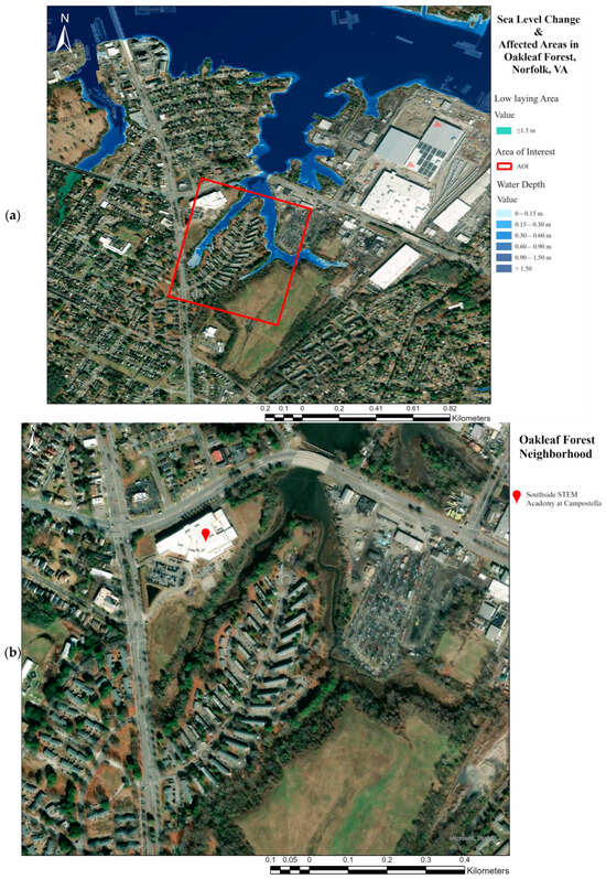
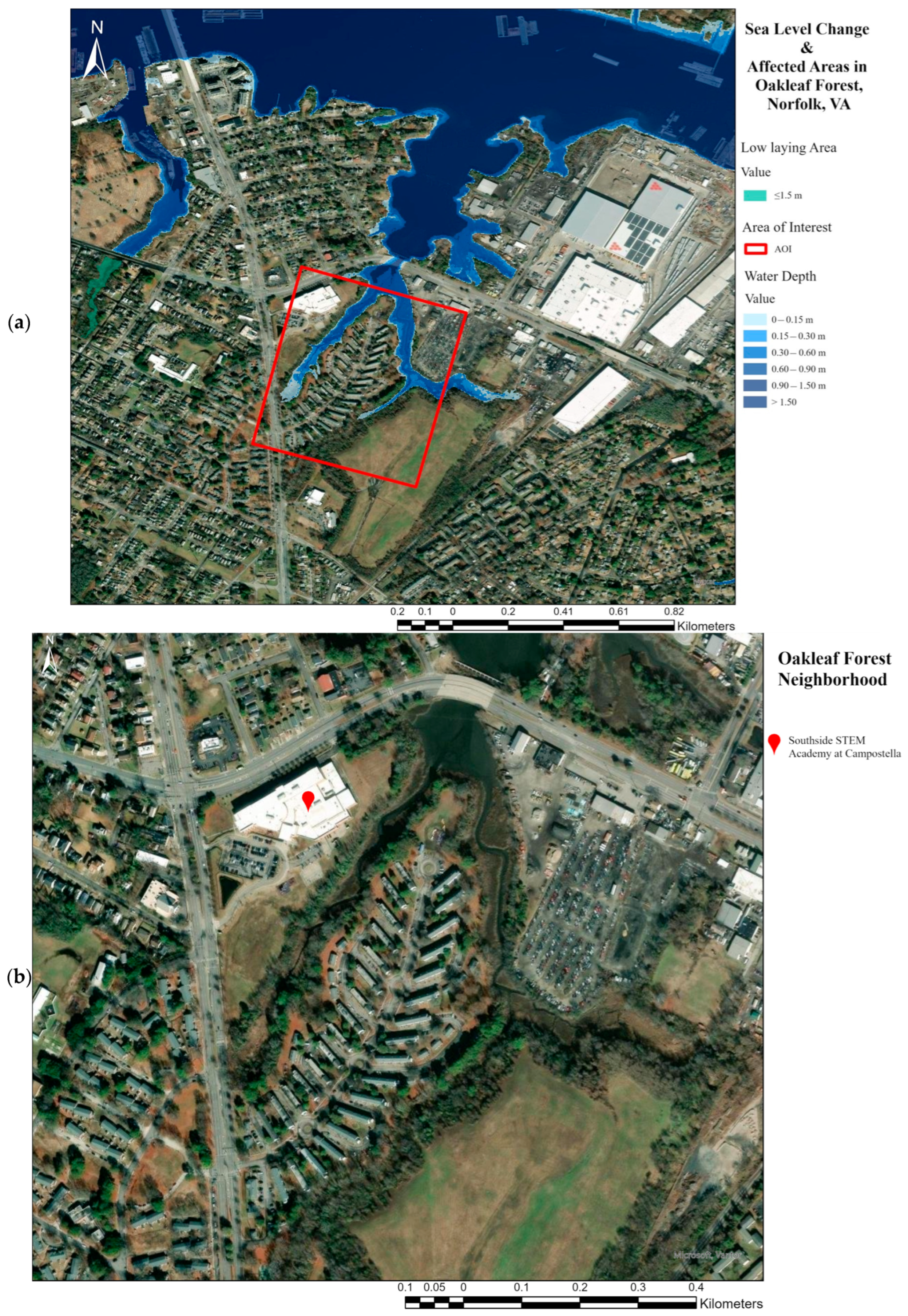
Expanding beyond the built environment, the surrounding natural landscape also plays a critical role in neighborhood flooding dynamics. Covering approximately 12.10 hectares (29.9 ac), Oakleaf Forest is bordered to the north by Steamboat Creek, a tributary of the Elizabeth River, which divides the neighborhood into eastern and western sections (Figure 4). The creek serves as a physical boundary and plays a vital role in the local ecosystem by offering a habitat conducive to water collection and supporting various wildlife. The shorelines on the eastern and western sides of Oakleaf Forest remain stable due to strong vegetative buffers and minimal wave action, supporting stormwater absorption, wildlife habitat, and bank stabilization.
Figure 4.
Oakleaf Forest Neighborhood, Norfolk, VA: (a) Projected SLC in the Oakleaf Forest [19], (b) urban layout of Oakleaf Forest [61].
However, the northern shoreline faces greater vulnerability, as wind exposure and over-water distance create conditions for erosion and ecological stress. This area represents the primary challenge, requiring targeted sustainable management and habitat restoration to maintain resilience and protect neighborhood functions.
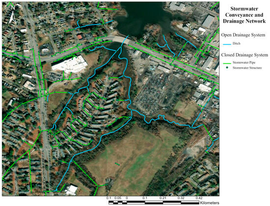
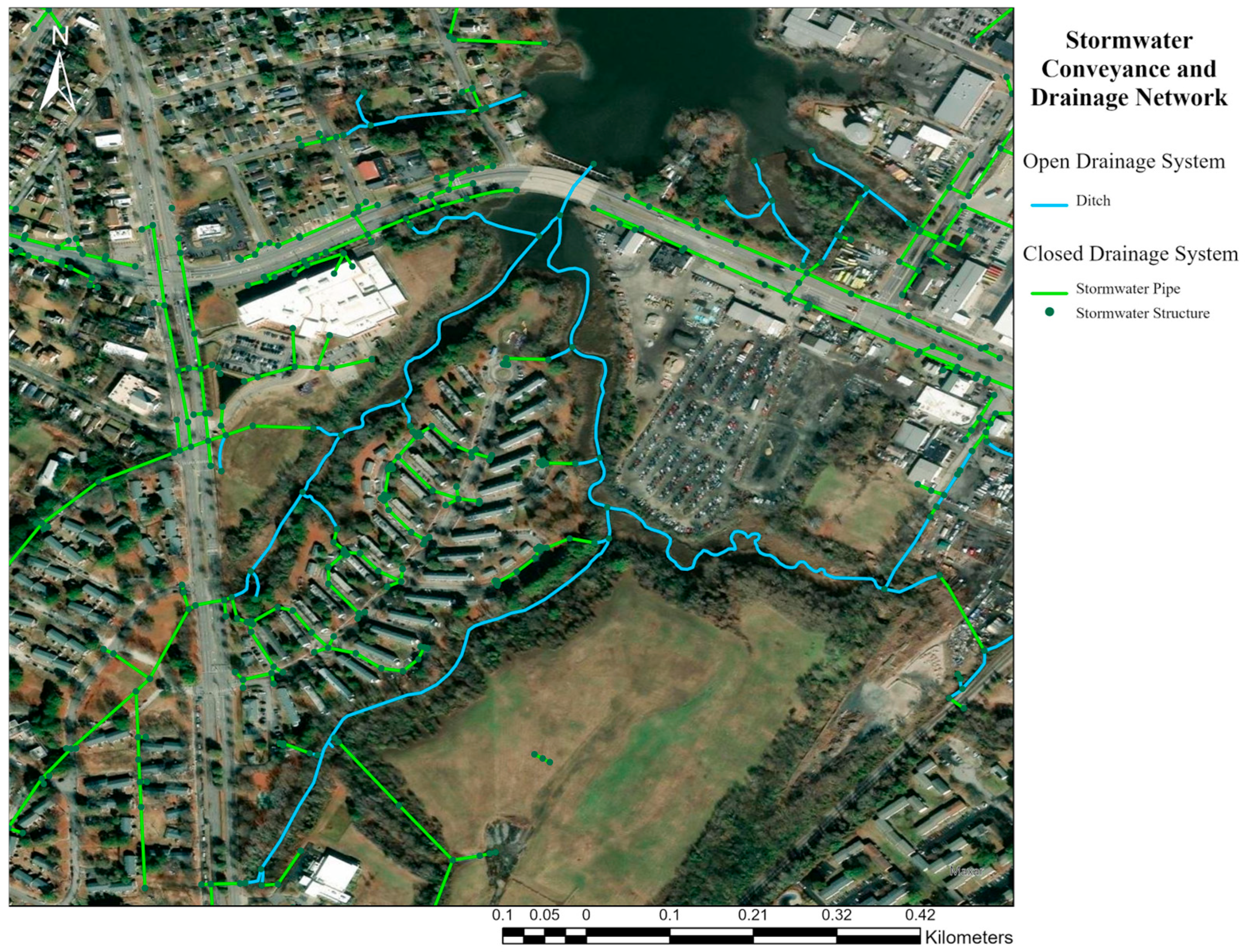
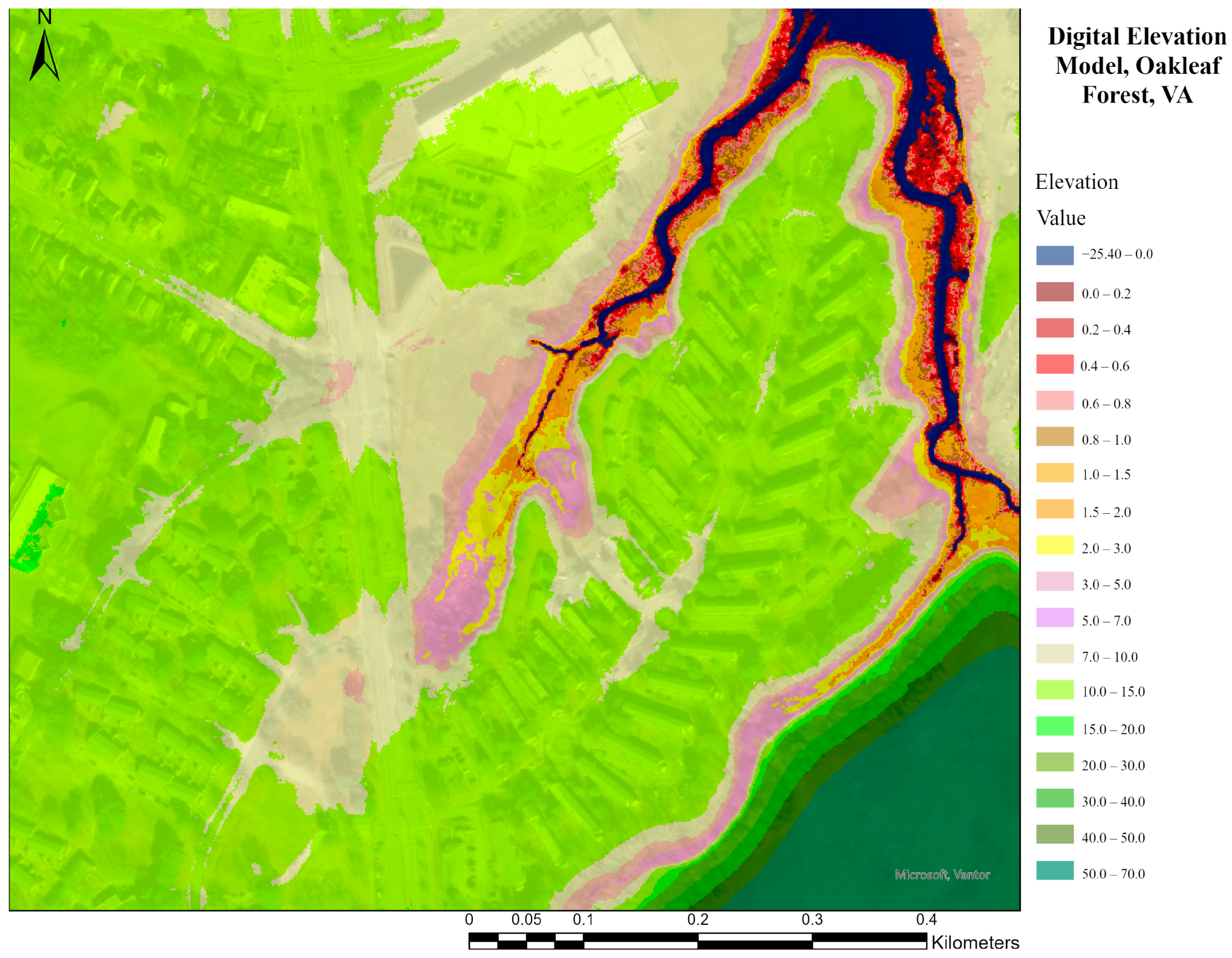
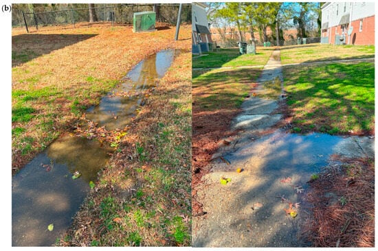
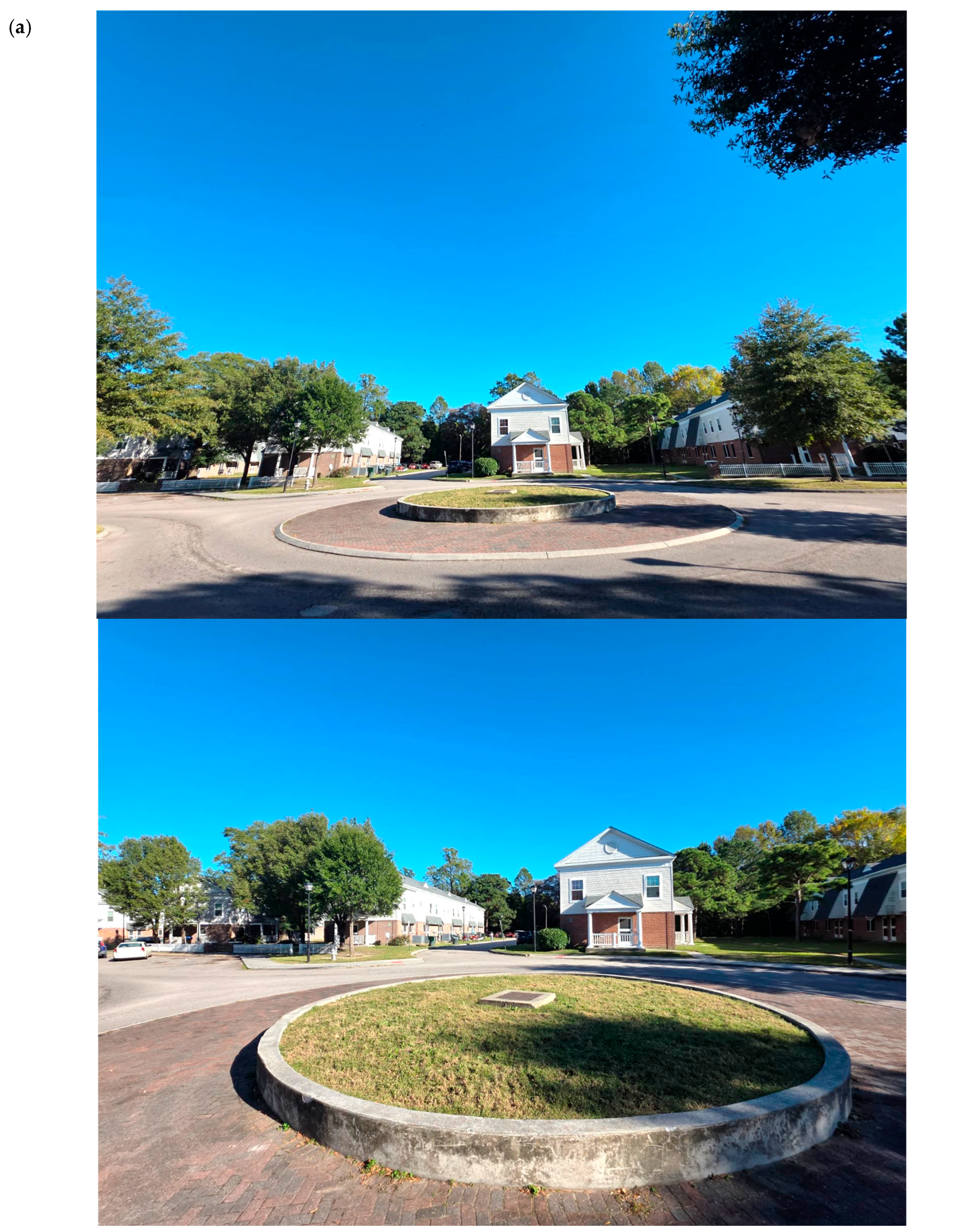
Land use within Oakleaf Forest includes streets 2.47 ha (6.10 ac), buildings 1.62 ha (4.00 ac), sidewalks 0.08 ha (0.20 ac), and soil 7.93 ha (18.26 ac), predominantly Altavista Urban Soil with smaller areas of Bohicket Muck and Johnston Silt Loam. Hydrologic and watershed analyses highlight significant runoff and flooding challenges driven by a shallow water Table 1.25 m (avg. 4.10 ft) and flat roadway elevations 2.60–3.81 m (8.53–12.5 ft). The large level terrain creates catchment areas defined by subtle high points, yet water frequently collects in scattered depressions instead of draining to a single outlet. The streets of Oakleaf Forest are classified as secondary roads with widths spanning between 6.00 and 6.61 m (19.69–21.69 ft). Ideally, they would feature crowned centers to direct runoff into gutter pans or curbs on both sides. However, most streets slope laterally, concentrating runoff on a single side, where water often remains stagnant due to the flat topography. The roundabouts, measuring 10.49 m (34.42 ft) in diameter with 4.27 m (14 ft) impervious brick cores, were originally designed as traffic-calming features but currently provide minimal stormwater management. Their raised interiors isolate inlets from roadway runoff, allowing only direct rainfall collection. Low points form neighborhood edges adjacent to the waterbody and near roundabouts. While these depressions contribute to localized flooding, they align with existing stormwater infrastructure and provide potential to divert runoff towards roundabouts, where suggested modifications could improve water management (Figure 5).
Figure 5.
Stormwater infrastructure in Oakleaf Forest, Norfolk, VA [62,63].
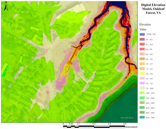
The community comprises dense residential developments with urbanization and impervious surfaces. The road layout is where Oakleaf derives its name. The residential roads stem from the neighborhood’s main branch, which includes four roundabouts throughout the neighborhood. The roads coil around its main road, creating semi-ellipses that run relatively flat. The district is portrayed in Figure 6. Steamboat Creek, an Elizabeth River tributary, surrounds the northern tip of Oakleaf Forest. This waterbody splits itself along the neighborhood’s east and west, outlining a majority of the space with a haven for water collection. The soils in the community are predominantly Altavista–Urban (residential settings, 0–3% slope, Hydrologic Soil Group C), indicating slow infiltration. Small inclusions of Bohicket muck (0–1% slope, HSG D, frequently flooded) and Johnston silt loam (HSG D, poor drainage as shown in Figure 5) are also present. Together, these soil conditions, especially the HSG C–D classes, suggest limited infiltration capacity and elevated flood susceptibility across portions of this site (Figure 6).
Figure 6.
Digital elevation model for Oakleaf Forest, Norfolk, VA (1 m resolution) [64].
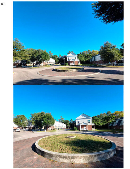
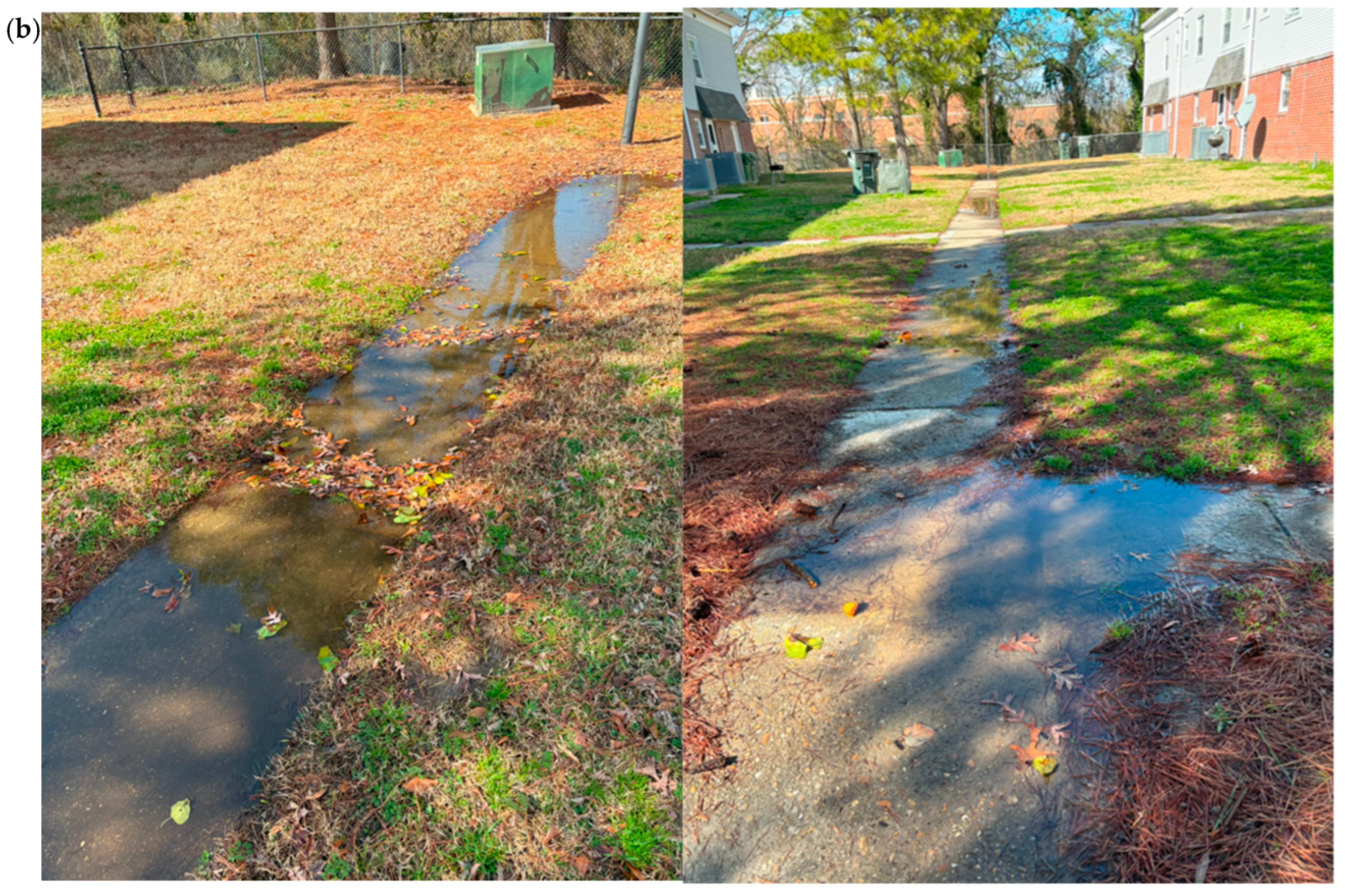
Oakleaf Forest has various residential pathways that connect residences to roadways. Site visits revealed that sidewalks experience frequent ponding during rainfall due to limited drainage capacity and a shallow water table, forcing residents to walk through standing water and mud. Low points occur near neighborhood edges, adjacent to the waterbody, and around roundabouts. The total disturbed impervious area is 1310 m2 (14,101 ft2), with 18 sidewalk cells averaging 73 m2 (785.76 ft2) each. The average lot size between large buildings is 841 m2 (9052.4 ft2). High water tables 1–1.5 m (3.28–4.92 ft), interpolated at 1.25 m (4.10 ft), limiting the effectiveness of subsurface water storage. Sidewalk elevations are 3.48 m (11.42 ft) NAVD88. To address runoff, three types of permeable pavements were analyzed as alternatives to concrete sidewalks: porous concrete, porous asphalt, and interlocking pavers, following Virginia’s Best Management Practices (BMPs) Clearinghouse guidelines [65]. With a projected 0.91 m (3 ft) SLC, risks of tidal encroachment, shoreline erosion, and structural instability will intensify, underscoring the urgency of resilient stormwater strategies (Figure 7).
Figure 7.
Key challenges and flood-prone locations in Oakleaf Forest, Norfolk, VA: (a) roundabout [66], (b) residential pathways [67,68].
In summary, Oakleaf Forest faces significant stormwater management challenges due to its flat topography, shallow water table, sloped yards, and extensive impervious surfaces. Multi-scale nature-based solutions, including permeable pavements, rain gardens, bioswales, rainwater harvesting, multipurpose roundabouts, and terraced shorelines—offer a resilient, cost-effective approach to mitigate flooding, improve water quality, and enhance ecological and social functions. Implementing these interventions provides a sustainable framework for adapting Oakleaf Forest and similar underserved coastal communities to prepare for current and future flood risks.
5. Nature-Based Solutions Proposal for Flood Mitigation and Community Resilience in Oakleaf Forest, Norfolk, Virginia
5.1. Redesigning Roundabouts to Enhance Stormwater Management: Runoff Control, Filtration, and Groundwater Recharge
Throughout the Oakleaf Forest property, several roundabouts are elevated higher than the adjacent streets. These roundabouts were identified by the team as opportunities to implement stormwater management strategies through nature-based solutions. The neighborhood roundabouts were evaluated for their potential to enhance runoff control, filtration, and groundwater recharge, while also maintaining their role as traffic-calming features.
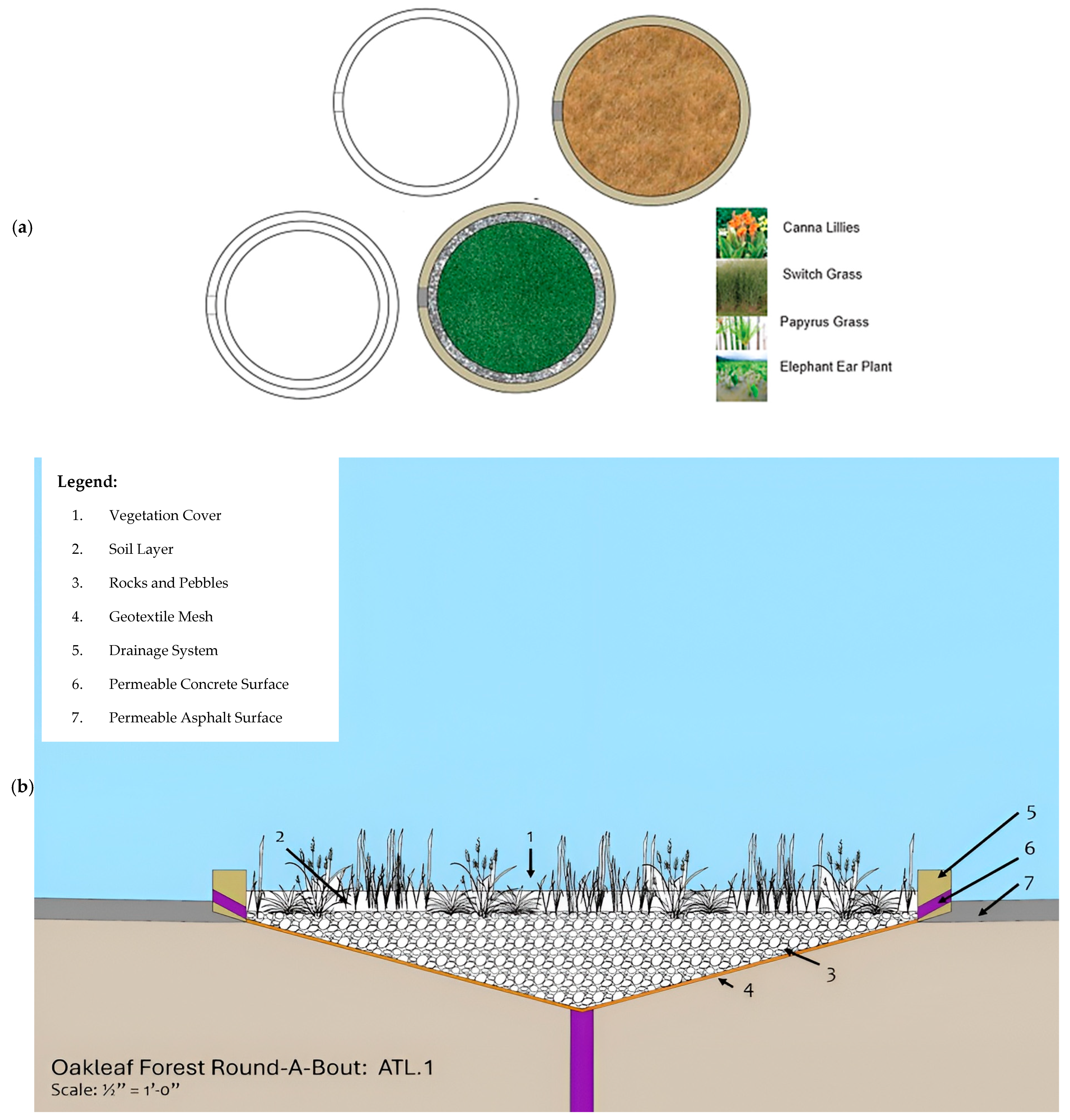
Strategies considered included creating small retention ponds, extending the permeable surface area of the roundabout, and adapting the roundabouts into rain gardens. Two design iterations were developed for retention-based solutions: Design Solution 1 introduces two smaller risers and orifices, ensuring that the entire pond experiences low flow [36,37]. This approach was conceived to allow for a central focal point—such as a statue or sign—within the roundabout, making it a visual landmark while simultaneously managing stormwater. Design Solution 2 replaces the pond with a rain garden [43,44,45], relying on an amphibious terrain that stores and drains water through aggregate into a central pipe. Unlike the permanently inundated pond, this approach avoids stagnation issues that could encourage mosquito breeding and reduce long-term maintenance needs.
The proposed redesign lowers the grass bed within the roundabout to align with the street gradient and introduces channels along the outer core, enabling water to bypass the brick layer and flow into inlets. Concrete walls are retained to discourage speeding, with added slits directing water into the drainage system. Surrounding elevations of 3.2–3.35 m (10.5–10.99 ft) enable concentrated flow into the roundabout. Hydrologic calculations suggest that this redesign increases retention capacity, reducing accumulated runoff by approximately 41.14 m3 (1452.85 ft3) and removing 0.97 kg (2.14 lb) of total phosphorus annually exceeding the target reduction by 0.60 kg (1.32 lb). These conservative estimates indicate that, when combined with existing inlets and drainage, the roundabouts could manage even larger runoff volumes.
Reconstruction involves pavement demolition, cutting channels into brick and concrete, patching with hydraulic cement, and excavation to lower and level the grass bed, followed by reseeding with native plants such as Zoysia grass for minimal maintenance [37,38,39,40,41,42,43,44,45,46,47,48,49,50,51,52,53,54,55,56,57,58,59,60,61,62,63,64,65,66,67,68,69,70,71]. While prior proposals for central rain gardens were rejected by the NRHA due to maintenance concerns, echoed by poor performance of similar systems in nearby Chesterfield Heights, the combined evaluation of pond-based and rain garden strategies demonstrates the flexibility of roundabout retrofits. Ultimately, the recommended approach favors grass swales integrated with inlets, providing a cost-effective, low-maintenance, and community-aligned solution that reduces runoff by approximately 9.9% while advancing neighborhood-scale flood resilience (Figure 8).
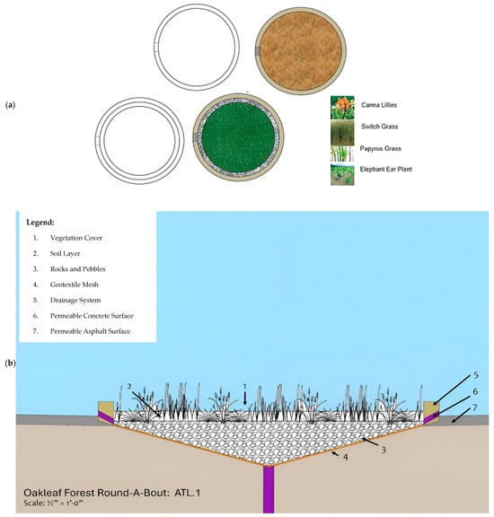
Figure 8.
Redesigned roundabout for stormwater management [72]: (a) native plants, such as Zoysia grass, to minimize maintenance while enhancing biodiversity, (b) a rain garden with amphibious terrain that stores and drains water through aggregate into a central pipe.
5.2. Redesigning Residential Buildings’ Yards and Sidewalks to Manage Stormwater, and Enhancing Runoff Control
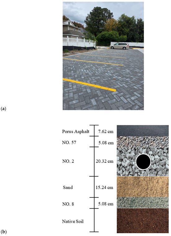
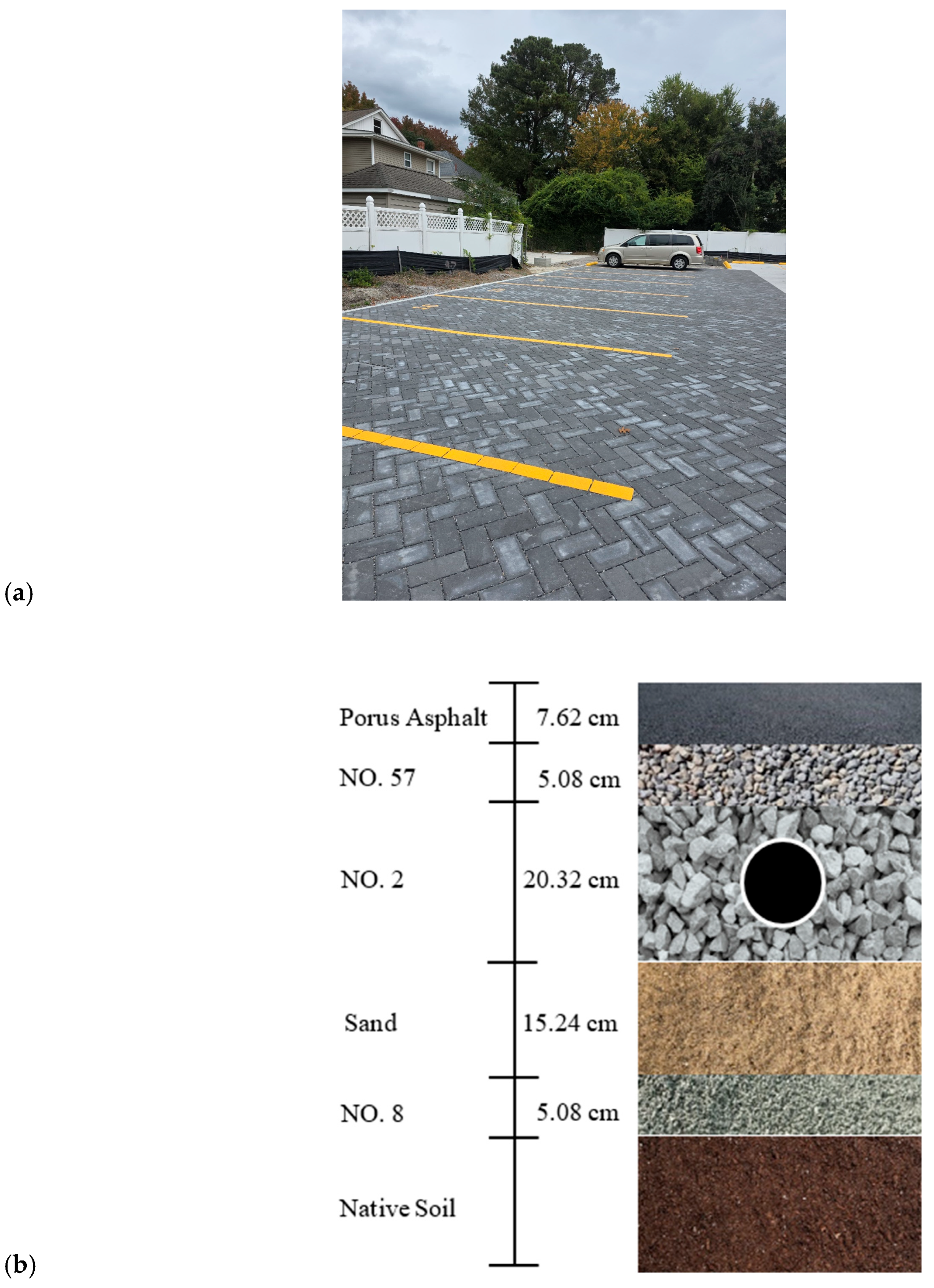
Permeable surfaces, including sidewalks, driveways, and pathways, are essential for managing stormwater at its source by controlling runoff and promoting groundwater recharge. Common materials such as porous asphalt, porous concrete, resin-bound materials, gravel, and interlocking pavers allow rainwater to infiltrate the ground or an underlying stone reservoir, reducing reliance on conventional drainage systems [50] rates of 3.05 m per day (≈10 ft/day) and long service life (20–30 years) but may be less feasible for smaller, disconnected areas. Interlocking pavers, suitable for microscale applications, offer moderate permeability of 0.61 m per day (≈2 ft/day) and easy maintenance. Porous asphalt systems use layered construction, including reservoir stone, underdrains, and filter layers to store and filter runoff effectively (Figure 9).
Figure 9.
Permeable pavement for stormwater management: (a) previous pavement for parking lot, Norfolk, VA [73]; (b) components and functional details of previous concrete pavement [74].
As can be seen in Table 2, calculations show that redesigning sidewalks with these permeable pavements can capture approximately 127 m3 (4484.96 ft3) of stormwater and remove 1.30 kg (2.87 lb) of total phosphorus per year, surpassing reduction targets. Implementation is cost-effective and requires minimal long-term maintenance, ensuring residents can move through the neighborhood without exposure to standing water or mud.
Table 2.
Drainage Area Evaluation in Oakleaf Forest, Norfolk, VA.
The porous asphalt design follows the Virginia DEQ Stormwater Design Specification Manual [75] and consists of five layers with an underdrain system. Starting at 3.47 m (11.39 ft) elevation, the layers include: 7.62 cm (3 in) porous asphalt, 5.08 cm (2 in) No. 57 bedding stone, No. 2 reservoir stone 20.32 cm (8 in) with a 10.16 m (4 in) cm perforated PVC underdrain (9.52 mm (-in) perforations every 15.24 cm (6 in), 0.5% slope), 15.24 cm (6 in) sand filter (ASTM C33), and 5.08 cm (2 in) No. 8 choker stone separating the system from native soils. Underdrains connect to existing street piping, and a 60.96 cm (2 ft) clearance from the reservoir’s bottom to the water table accommodates the high-water table.
Maintenance includes periodic vacuum sweeping, pressure washing, and repaving or installing a drop inlet if damaged. Overall, integrating permeable pavements as a nature-based solution enhances local flood resilience, supports groundwater recharge, and contributes to sustainable urban infrastructure.
In addition to redesigning sidewalks with these permeable pavements, the yard spaces between the houses were selected as an area of focus, looking specifically at places where pedestrian walkways ran between the buildings. Residents of the neighborhood spoke of flooding occurring on the central sidewalk after storms. This is likely due to the sloped yards draining water towards the center pathway. As a proposed solution, dry swales could be installed between the yards and the sidewalks. Swales are shallow, grassy ditches that mimic natural drainage channels, designed to collect and slowly direct rainwater runoff away from paved surfaces [76,77].
This strategy would allow the water running off the yards to be collected and channeled off the site instead of pooling onto the sidewalk [78]. The dry swale is also lower maintenance than a wet bioswale. This combination would not only mitigate frequent flooding on sidewalks and streets in Oakleaf Forest but also promote groundwater recharge, reduce peak runoff, and improve overall resilience to heavy rainfall events.
5.3. Redesigning Rooftop and Gutter Systems to Mitigate Runoff, Pollutant Loads, and Flooding Impacts
In Oakleaf Forest, houses equipped with disconnecting rooftops carry rainwater from the roof gutter down to the vegetated areas, allowing the runoff and pollutants to infiltrate. However, because downspouts outlet to limited vegetated areas, excess runoff flows straight to the road and worsens street flooding. Additionally, in relatively flat areas like Oakleaf Forest due to high water table conditions, using the infiltration method might not be the best option [79].
Combining the rooftop disconnection with rain barrels can further reduce runoff since rain barrels can store some of the water for later reuse. Additionally, rooftop disconnections paired with gutters and rain barrels provide an effective, low-cost strategy. The NRHA mentioned their plans of redoing the roofs in the development and advised the students that the solutions implemented should be low-cost and relatively non-invasive to the residents, as well as in alignment to the NHRA’s future redevelopment plans for the site.
The current site yielded two different classifications of buildings: large and small. Of the 53 residential buildings, there were 35 large buildings. The average size of these buildings was roughly 390.19 m2 (≈4200 ft2) and they are divided into 8 residences. These large 2-story buildings have flat roofs that slope to one side and have existing roof gutters and 3 downspouts. However, these downspouts discharge water to the limited vegetated space in the fronts of the houses that face the roads, meaning that the runoff that does not infiltrate flows directly to the roads, adding to the current street flooding conditions. Implementing rain barrels at the current downspouts will aid in intercepting this additional runoff.
The second classification of buildings, small, consists of 18 buildings. These buildings are one-story with an average square footage of about 139.35 m2 (≈1500 ft2) and consist of two residences. Unlike the large buildings, small buildings do not have existing gutters or downspouts. This lack of runoff diversion will contribute to foundation damage and high amounts of runoff. With the drainage pattern of their A-line roofs, these small buildings need two downspouts with rain barrels to intercept the runoff from both sides of the roofs.
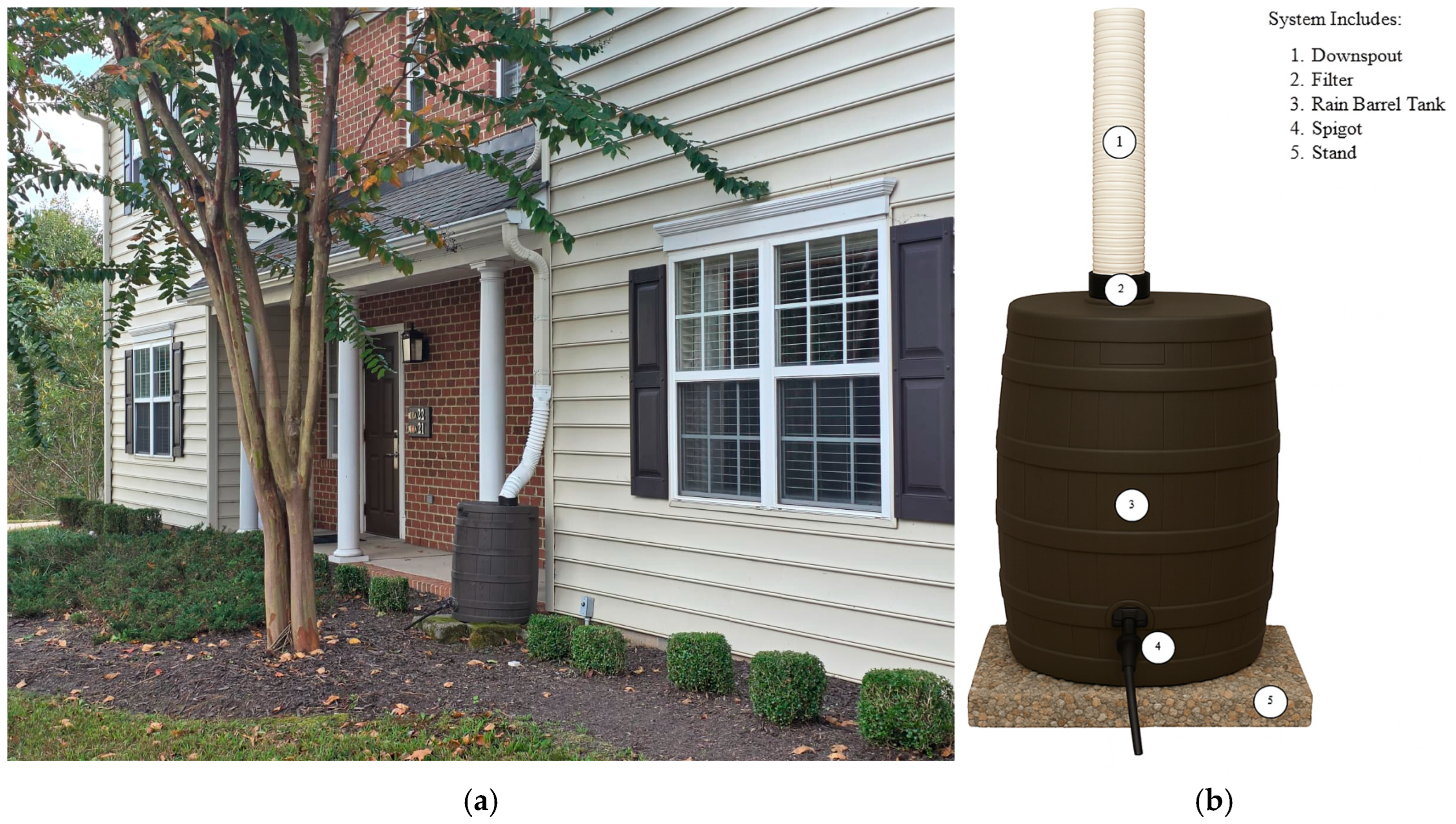
Typical rooftop disconnections and rain barrels are designed for the 90th percentile rainfall depth, which is 25.40 mm (≈1 in) of rainfall. According to the James River Association, the typical rain barrel sizes for residential use are 208.20 L (55 gal) and 340.69 L (90 gal). Due to the limited space surrounding the buildings, the 208.20 L (55 gal) rain barrels are more suitable for the site. The total roof area of 1.62 ha (4.0 ac) was evaluated, with calculated water demand of 17.53 L per day (4.63 gal/day) for small buildings and 46.71 L per day (12.34 gal/day) for large buildings. Runoff reduction credits are 19% and 27%, respectively. Implementation decreases total runoff by 99.90 cubic meters (3527.94 ft3) annually and removes 1.00 kg (2.21 lb) of total phosphorus per year. To prevent erosion, the barrels sit on concrete pads. Overall, integrating rooftop disconnections with rain barrels provides an economical, effective, and low-maintenance GI solution to mitigate stormwater runoff, reduce pollutants, and protect building foundations in Oakleaf Forest (Figure 10).
Figure 10.
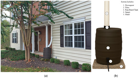
A rain barrel system captures and stores rooftop runoff for non-potable uses such as landscape irrigation, lawn maintenance, and outdoor cleaning. (a) Rain barrel in residential buildings in Williamsburg, VA [80]; (b) components of a rain barrel system [81].
Through the design process and analysis, several alternatives emerged. Based on space constraints of the site, an alternative was relocating the rain barrels underground to create room for more capacity. While originally appearing as an innovative solution, this option proved to be unfeasible due to several factors.
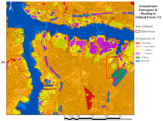
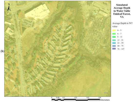
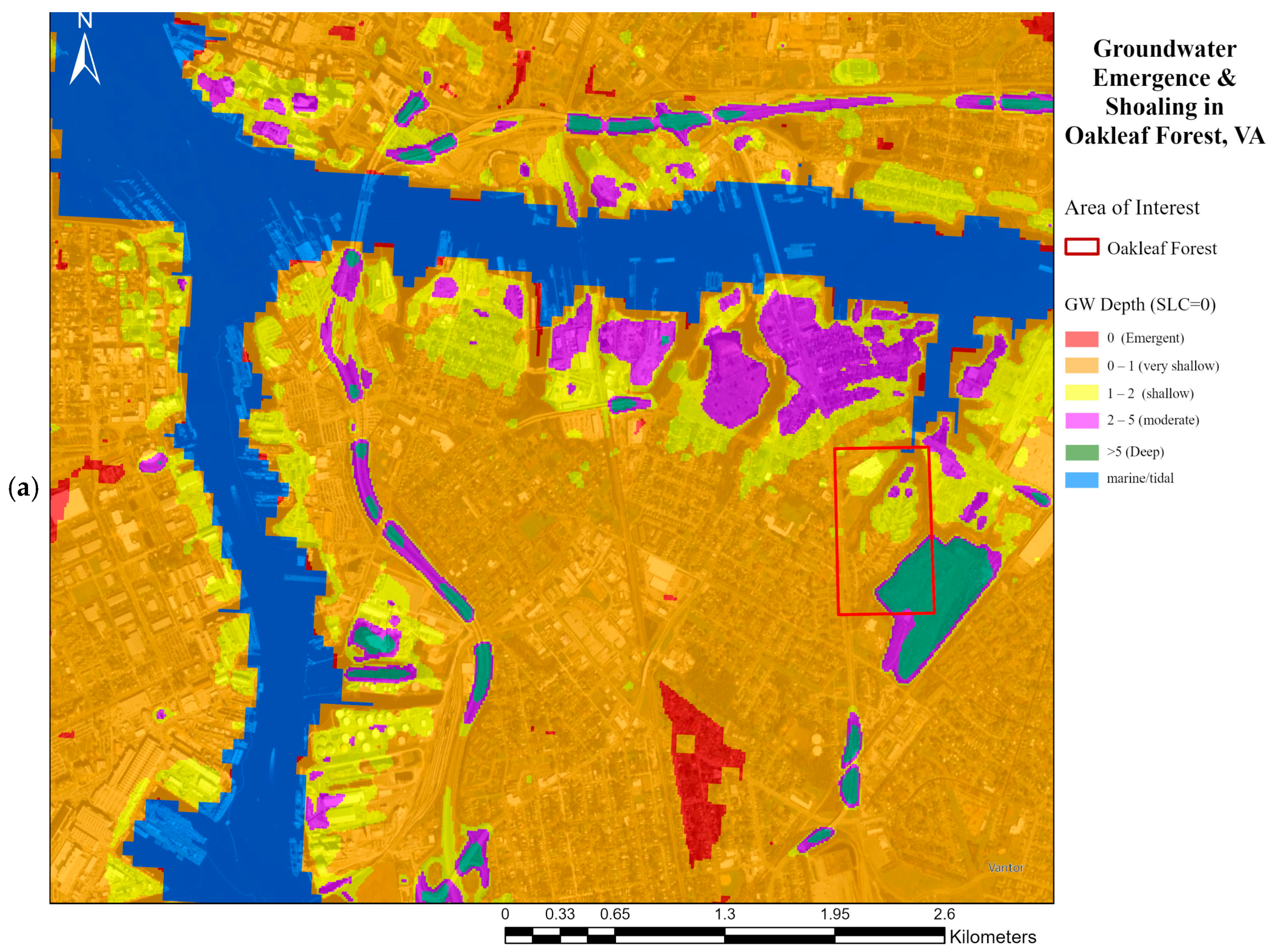
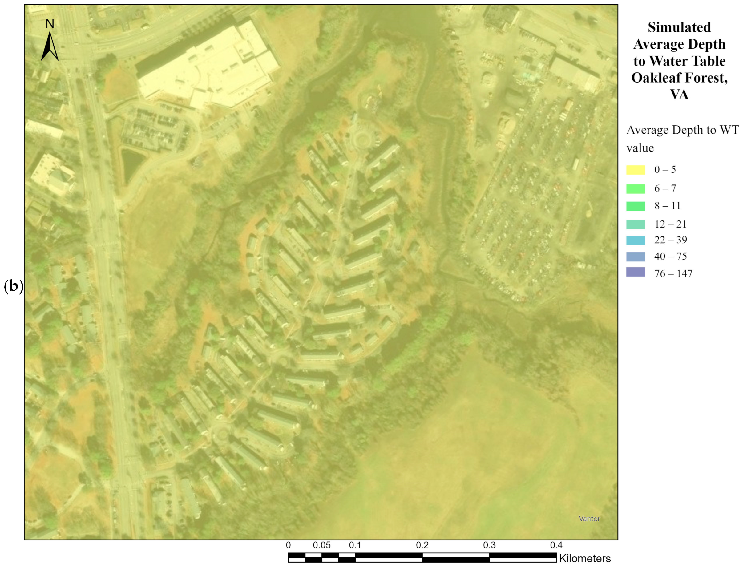
As shown in Figure 11a, approximately half of the site has a high groundwater table between 1 to 2 m (~3.28–6.56 ft) below ground surface, and the remaining half has a very high groundwater table is between 0 to 1 m (0–3.28 ft). With the water table generally within ~0–5 m (0–16.40 ft) of the surface (Figure 11b) underground tanks would be susceptible to buoyancy. In addition, buried systems have higher operation and maintenance burdens due to restricted access for inspection and cleaning.
Figure 11.
Hydrologic conditions at oakleaf forest. (a) Depth to the groundwater [82], (b) simulated average depth to water table [83].
Another considered alternative solution was a cistern, a larger storage container that can take runoff from multiple downspouts, by pressurizing the system (adding pump) the stored rainwater could be used for non-potable purposes such as toilet flushing and laundry. This solution increases the amount of water reused, further reducing the amount of runoffs and overflows from the water tank.
While this solution may increase the efficiency of rainwater reuse due to space limitations, utilizing cisterns might not be the best option. Integrating the rainwater collection with plumbing increases the associated maintenance costs. Plumbing issues are now directly tied to the water tanks, increasing the number of variables in repairs. Furthermore, it would be expensive to reroute the water supply from a non-potable water source. Since incorporating more non-potable water reuse complicates the approach and raises the overall cost, this study examines low-cost, straightforward solutions to the current flooding and runoff problems.
5.4. Designing a Living Shoreline to Protect and Remediate Ecosystems to Prevent Flooding and Bank Stabilization
Shoreline adaptation in the Southside communities of Norfolk was one of the focus areas of potential improvement. Over time, the shoreline of Norfolk has been eroding, increasing flooding and putting more property at risk. A living shoreline, using natural aggregates and vegetation, reduces wave energy, enhances wetland habitats, and limits nutrient runoff [84,85]. This approach also helps combat the erosion of Norfolk’s shoreline around Oakleaf Forest.
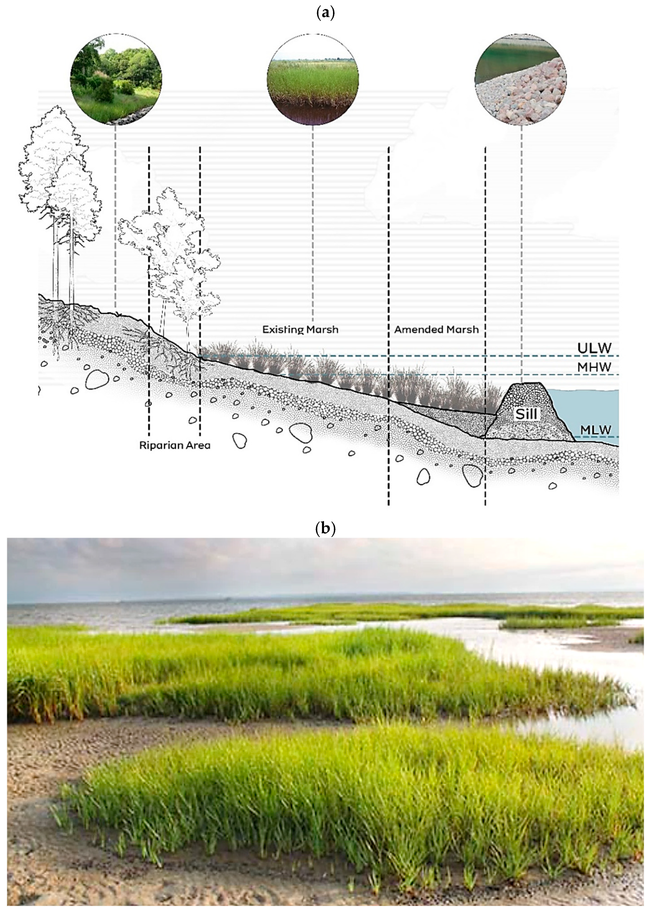
The Oakleaf Forest peninsula has west, east, and north-facing banks. Although the peninsula shape has an overall irregular shoreline, the north-facing shore resembles a straight morphology. Oakleaf’s north shore depth is 0.91 m (3 ft), providing ideal depths for a low sill design. A rock sill absorbs wave energy, and a marsh wetland acts as a physical barrier for high tides and protects banks from erosion.
The proposed marsh-and-sill design follows recommendations from the VIMS’s guidelines for living shorelines along with data provided by the NOAA [86]. A marsh and sill design is a hybrid shoreline protection method that will allow for the extension of the existing marsh area to account for SLC and provide greater protection further up the bank. A wetland will harvest the growth of marsh vegetation. The sill aids in breaking wave energy and holds a sand backfill.
The slope of the wetland and sill dimensions were determined using the mean high water (MHW), mean low water (MLW) levels, mean tide level (MTL), and upper limit of wetlands (ULW). These values were all obtained using tidal information recorded by NOAA at Money Point observation site (Table 3).
Table 3.
Tidal Elevation at Money Point [87].
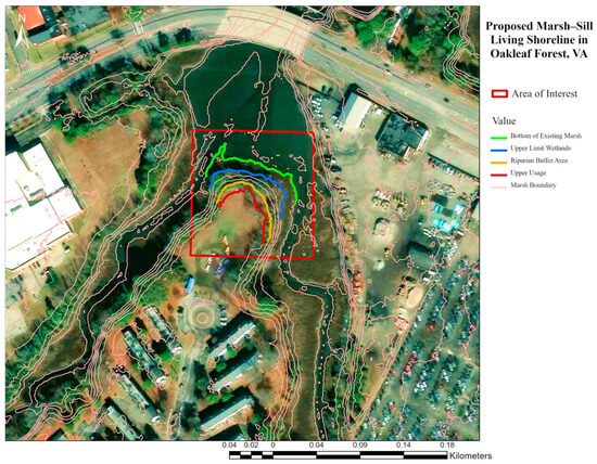
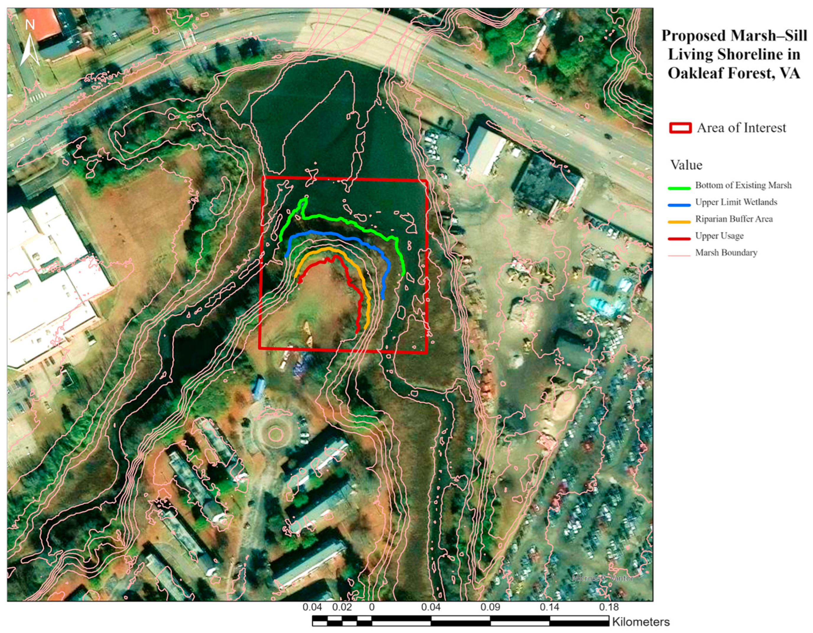
The north-facing bank (22.92 m) (75.21 ft) has the greatest fetch, which is the distance over water that the wind blows in a single direction, compared with the east and west banks, making it the most susceptible to shoreline erosion. Inclusion of a marsh sill is the best solution for this location (Figure 12).
Figure 12.
Proposed Living Shoreline Site Location and Components [88].
The bank is already stabilized by an established riparian zone of trees and shrubs, and an existing marsh is separated from upland grass fields and residences by a fence line. At the northern end, the fields are at 3.05 m (10 ft) elevation, and the tree line begins near 2.38 m (7.81 ft). The riparian area extends 9.36 m (30.71 ft) and drops 1.80 m (5.91 ft) to the ULW. The existing ~5:1 (H:V) riparian slope aligns with VIMS guidance, so no re-grading is required.
To address nuisance tidal flooding and the 0.51 m (1.67 ft) of SLC expected by 2050, the marsh will be extended about 4.57 m (15 ft) and combined with a low-profile sill suited to low-bank, low-energy conditions. Based on NOAA tidal datums at Money Point, VA (relative to MLLW), the newly planted marsh will maintain a 15:1 grade and be set between MLW and MTL. These wetlands provide primary wave attenuation and help preserve existing habitat. A sill will separate the amended marsh from open tides, dissipate wave energy, and retain the sand substrate until vegetation is established.
The sill toe will be set at MLW (0.48 m) (1.56 ft) NAVD88) and the crest just below MHW (0.30 m) (+0.99 ft) (NAVD88) [89] to allow routine overtopping under low-energy conditions. Specific sill dimensions are provided in Table 4, and because the marsh length is less than 30.48 m (100 ft), tidal gaps are not required.
Table 4.
Flood Sill Design.
The materials required to construct the living shoreline with the marsh include sand, plants and rock sill (Figure 13a). Coarse-grained sand (D50 = 0.6 mm, <10% passing sieve 100) will be utilized to enhance resistance to wave action. It also provides new plants with adequate oxygen and space for development. In the marsh section, 8.51 m2 (91.60 ft2) of sand per linear meter is required, for a total of 195 m3 (255.05 yd3). Before planting, a settling period of two weeks is recommended by VIMs [90].
For the marsh zone, smooth cordgrass (Spartina alterniflora) will be planted from the sill toward the existing marsh (Figure 13b). As a native low-marsh species, it naturally occupies elevations between MLW and MHW and is adopted to salinity of ~10–25 ppt, making it well-suited to this site [91].
For designing the sill, since the effective fetch is short, 0.16 to 1.61 km (0.1–1.0 mi), it indicates a low wave-energy shoreline. The sill will be built of durable igneous rock to make up the entire sill. Voids between stones permit limited water exchange, and the crest is set to allow routine tidal overtopping under normal conditions. A total of 24.71 m3 (32.32 yd3) of mixed armor stone, mostly Class I ((22.68 –68.04 kg) (50–150 lbs)) with some Class II ((68.04–226.80 kg) (150 to 500 lbs)), is specified for a 1:1 side slope.
Figure 13.
Living shoreline to restore and remediate ecosystems: The concept of a hybrid green/gray infrastructure combines structural defenses, with living elements like marshes, native plants, and trees to slow wave action, reduce erosion, mitigate storm surge, enhance climate resilience, (a) proposed marsh sill design [92], (b) spartina alterniflora (smooth cordgrass), planted from sill base to marsh edge, supports habitat, improves local aesthetics and community mental health and wellness [93].
5.5. Design of the Pedestrian Bridge
During the site visit to Oakleaf Forest, the community reported that heavy rains make walking along Campostella Boulevard hazardous for students due to flooding and fast-moving traffic. Most students in the northwest neighborhood walk this route to reach the K-8 Southside STEM Academy.
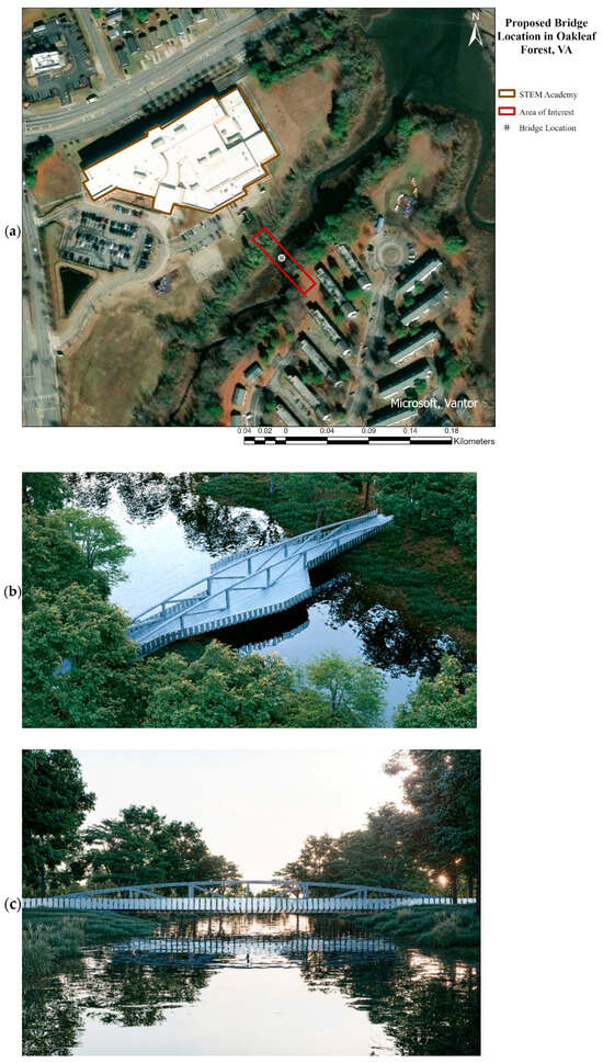
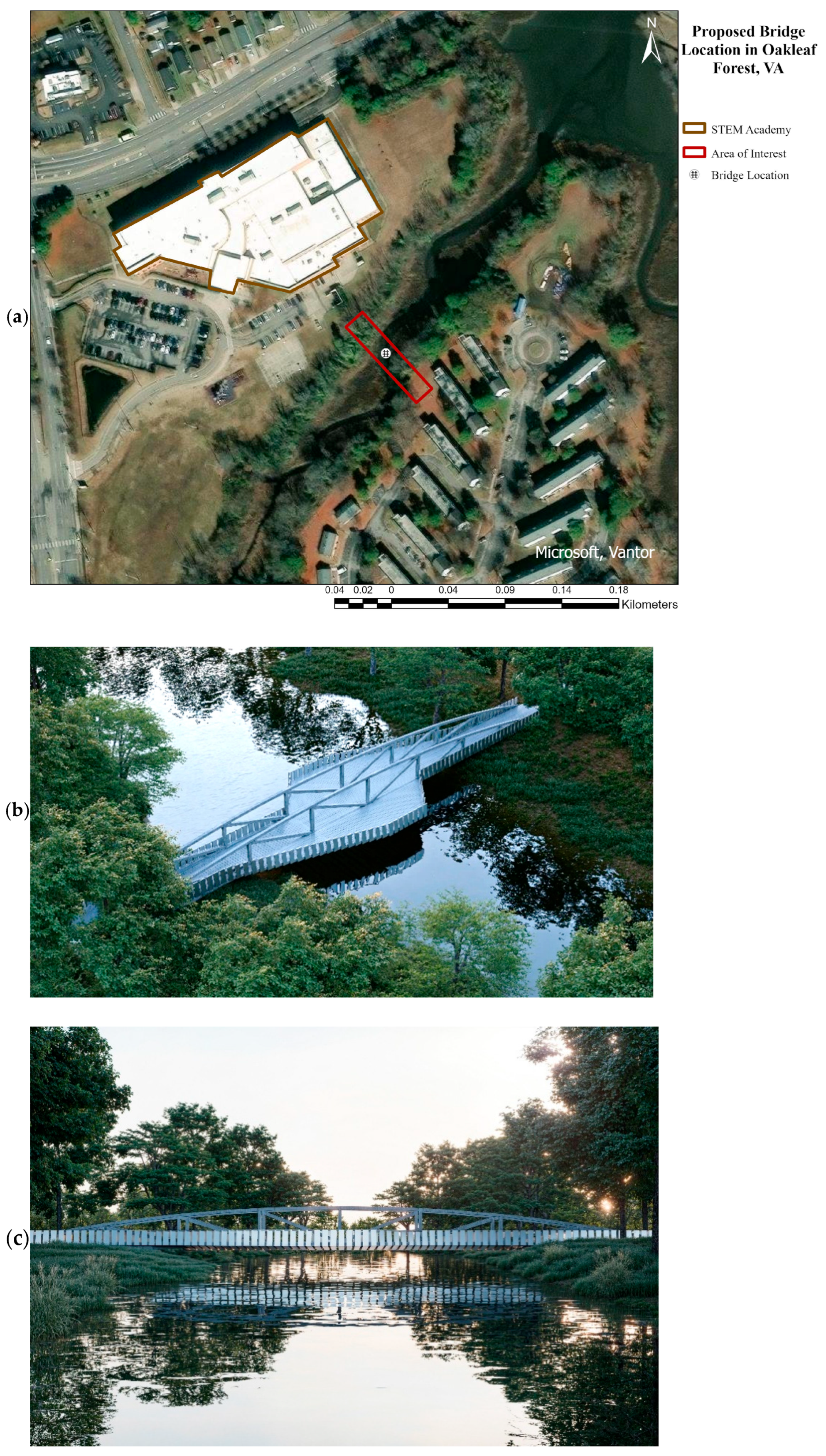
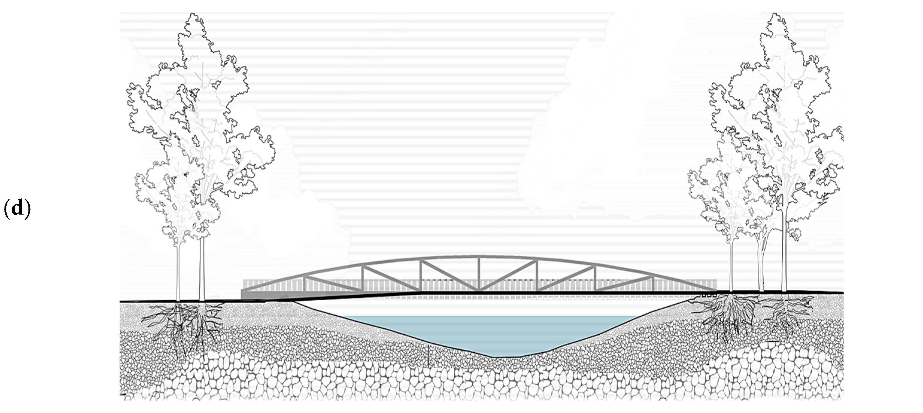
To improve safety, a 60.96−m (200 ft) pedestrian bridge is proposed over Steamboat Creek, directly connecting the neighborhood to the school. This bridge would provide a safer, faster route, reduce exposure to flood hazards along the current sidewalk, and support early engagement in STEM education while helping students develop essential 21st-century skills.
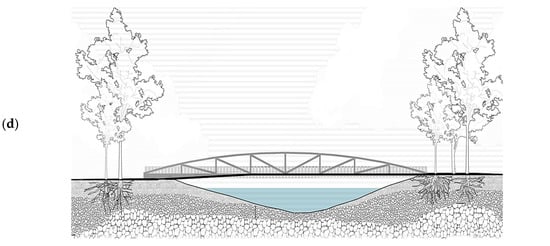
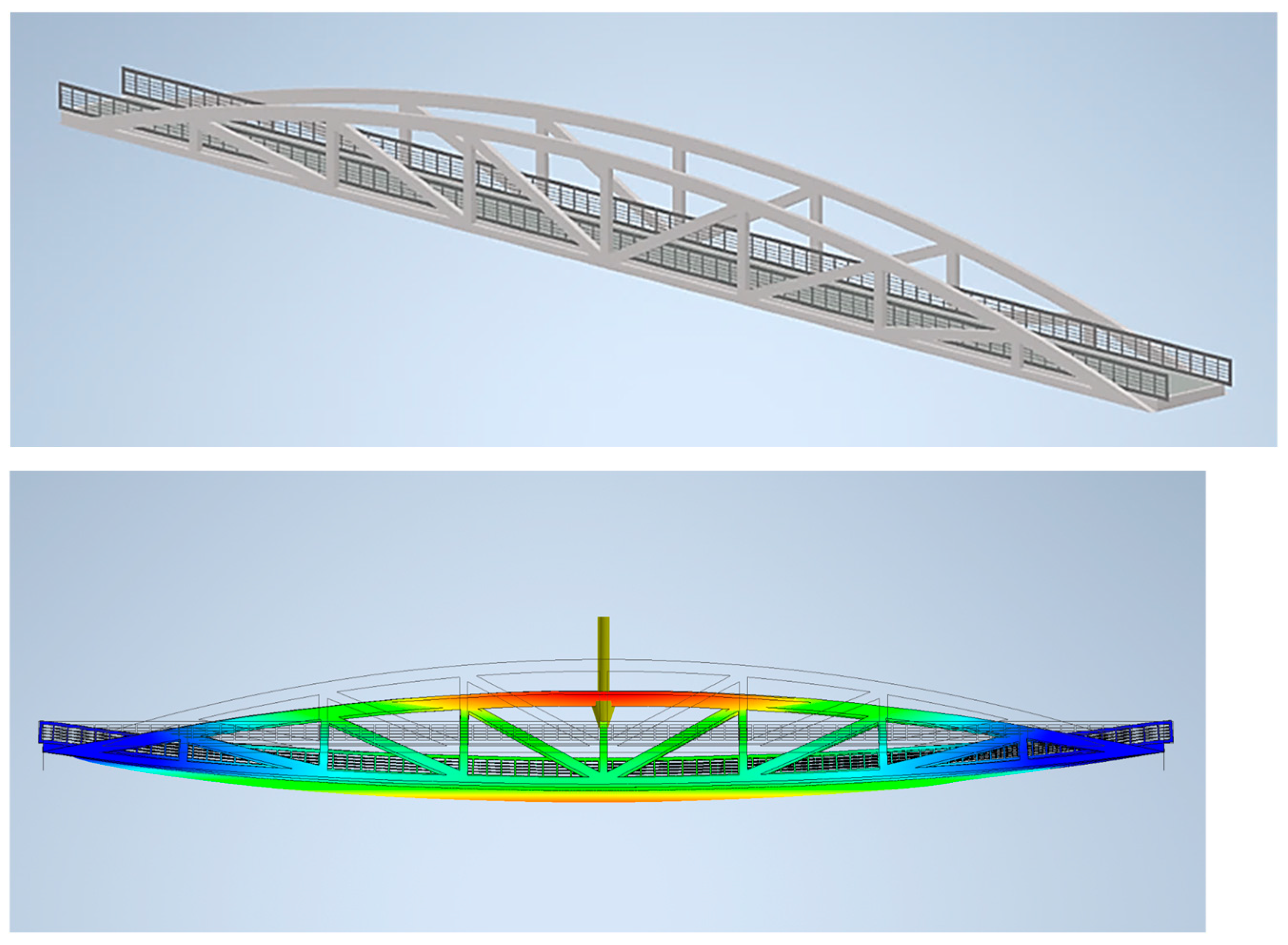
As a proposal, a 60.96−m (200 ft) pedestrian bridge over Steamboat Creek has been designed, including a truss system and two mid-spans outlooks. Due to CAD format limitations, the truss and outlooks were analyzed separately, with column designs checked for compression and buckling. The bridge will feature mulch and flagstone approaches on both sides, connecting the northwest Oakleaf neighborhood to the school area (Figure 14).
Figure 14.
Proposed pedestrian bridge over the creek connecting the housing community to the school in Oakleaf Forest, Norfolk, VA, providing a faster and safer route for students: (a) location [94], (b) architectural design concept [95], (c) seating/view area [95], (d) ADA-accessible access [95].
Construction of the approaches involves layers of gravel, landscaping fabric, sand, stone, and mulch. An informational plaque discussing Norfolk’s history and flooding issues will be attached to the western outlook railing. The team estimated the cost of this pedestrian bridge to be $1.4 million (Figure 15).
Figure 15.
Structural design and truss deflection analysis of the proposed pedestrian bridge in Oakleaf Forest, Norfolk VA [96].
6. Conclusions
SLC is an implacable force. In coastal cities where rising waters precipitate recurrent nuisance flooding, the question may not be whether retreat is necessary, but when will retreat be necessary. For low-income communities and coastal communities of color, this presents an impossible choice.
Resilience, adaptation, and climate readiness may go a long way in securing vulnerable communities against threats of climate change, environmental degradation, and recurrent flooding, but in the far future, the landscape of low-lying regions such as Hampton Roads will be heavily changed by rising seas. For communities which lack the resources to move or lack the willingness to be dispersed and lose their networks, the answer may be to dig in and live in places as long as possible as water rises. This is the approach of the City of Norfolk as a whole, whose Office of Resilience has leveraged major initiatives to prevent damage from hurricanes, flooding, and erosion. Some of these initiatives may themselves be controversial as the beauty and the splendor of the urban waterfront is changed. Many community members who focus on aesthetics may find their minds changing after coming years of increasing flooding.
It is critical to act now and ensure the longevity of all communities in coastal cities like Norfolk, paying special attention to the needs of low-income communities of color, as flooding threatens life, limb, property, and infrastructural networks. Only with major investments at the federal, state, local, and city level can climate change, and SLC be held at bay in a year-to-year, delicate, and contingent balance.
Within Norfolk’s Southside, this project demonstrates how NbS and low-impact development (LID) can mitigate these challenges in ways that are both practical and community-centered. Interventions such as living shorelines, permeable pavers, dry swales, and rainwater harvesting reduce runoff, increase infiltration, and protect against erosion while enhancing neighborhood character and biodiversity.
In Oakleaf Forest, roundabout redesigns, rain barrels, and permeable pathways provide localized flood relief, while a pedestrian bridge ensures children have safe, flood-free access to school. Quantifiable results, such as nearly 249 cubic meters (8793.36 ft3) of runoff reduced through interventions, illustrate the tangible impact of these measures. By connecting new inlets to existing outflows and adopting green curb-and-gutter systems, the project advances both resilience and aesthetics.
These approaches align with global sustainability goals, from strengthening urban resilience (SDG 11) to conserving marine ecosystems (SDG 14) and fostering equity and inclusion (SDG 16). Ultimately, they offer a replicable blueprint for equitable, climate-ready communities in Norfolk and beyond.
Author Contributions
Conceptualization, F.S.; methodology, F.S., M.E.-U. and C.L.C.; validation, M.E.-U. and C.L.C.; formal analysis, F.B.; investigation, F.B.; data curation, F.B.; writing—original draft preparation, F.S.; writing—review and editing, M.E.-U. and C.L.C.; visualization, F.B.; supervision, M.E.-U. and C.L.C.; project administration, C.L.C. All authors have read and agreed to the published version of the manuscript.
Funding
This research was funded by the National Fish and Wildlife Foundation (NFWF) under Grant Index No. 559198 and Grant Fund No. 219189. The project was led by Dr. Mujde Erten-Unal (Principal Investigator), Department of Civil and Environmental Engineering, Old Dominion University, and Dr. Farzaneh Soflaei (Principal Investigator), Department of Architecture, Hampton University.
Institutional Review Board Statement
The Old Dominion University Arts & Letters Human Subjects Review Committee has determined this project is exempt from IRB review according to federal regulations.
Informed Consent Statement
Not applicable.
Data Availability Statement
All datasets generated and analyzed during the current study are included within the article. Appropriate citation of this article is required.
Acknowledgments
The authors gratefully acknowledge these institutions for their invaluable support and collaboration. Special recognition is given to Hampton University students whose contributions through coursework and project work significantly enriched this study: James Belle, Mckenzie Cleveland, Twajuon Palmer, Sydney Johnson, Eric Montgomery, Calla Adams, Nylah Stover, and Amari Ross. Additional thanks are extended to the Old Dominion University students for their dedicated contributions: Mckenna Drammeh, Kaileen Myers, Brian Wilczynski, Jean Kulick, Will Dawson, Chloe Barrett, Tristan Hobbs, Madison Millspaugh, Chrischa Schrock, Sam Wilt, and Garrett Belen.
Conflicts of Interest
The authors declare no conflict of interest.
Abbreviations
The following abbreviations are used in this manuscript:
| GMSL | Global Mean Sea Level |
| SLC | Sea Level Change |
| UN SDGs | UN Sustainable Development Goals |
| NbS | Nature-Based Solutions |
| GI | Green Infrastructure |
| NRHA | Norfolk Redevelopment and Housing Authority |
| CBPA | Chesapeake Bay Preservation Act |
| NOAA | National Oceanic and Atmospheric Administration |
| VIMS | Virginia Institute of Marine Science |
| MHW | Mean High Water |
| MLW | Mean Low Water |
| MTL | Mean Tide Level |
| ULW | Upper Limit of Wetlands |
References
- Lindsey, R. Climate Change: Global Sea Level. 2022. Available online: http://www.climate.gov/news-features/understanding-climate/climate-change-global-sea-level (accessed on 14 September 2025).
- NOAA Climate.gov. Sea Level Rise Scenarios Through 2100 (Graph, Adapted from Sweet et al., 2022). Available online: https://www.climate.gov/media/14136 (accessed on 14 September 2025).
- Kleinosky, L.R.; Yarnal, B.; Fisher, A. Vulnerability of Hampton Roads, Virginia to Storm-Surge Flooding and Sea-Level Rise. Nat. Hazards 2007, 40, 43–70. [Google Scholar] [CrossRef] [Scilit]
- Rozance, M.A.; Denton, A.; Marissa Matsler, A.; Grabowski, Z.; Mayhugh, W. Examining the scalar knowledge politics of risk within coastal sea level change adaptation planning knowledge systems. Environ. Sci. Policy 2019, 99, 105–114. [Google Scholar] [CrossRef] [Scilit]
- VanDervort, J. Sea level change and beyond: Is the US military prepared for climate change? Bull. At. Sci. 2020, 76, 145–149. [Google Scholar] [CrossRef] [Scilit]
- Doberstein, B.; Tadgell, A.; Rutledge, A. Managed retreat for climate change adaptation in coastal megacities: A comparison of policy and practice in Manila and Vancouver. J. Environ. Manag. 2020, 253, 109753. [Google Scholar] [CrossRef] [Scilit] [PubMed]
- Burley, D.; Jenkins, P.; Azcona, B. Loss, Attachment, and Place: Land Loss and Community in Coastal Louisiana. Res. Urban Policy 2006, 10, 21–42. [Google Scholar] [CrossRef] [Scilit]
- Barbier, E.B.; Hacker, S.D.; Kennedy, C.; Koch, E.W.; Stier, A.C.; Silliman, B.R. The value of estuarine and coastal ecosystem services. Ecol. Monogr. 2011, 81, 169–193. [Google Scholar] [CrossRef] [Scilit]
- Alderman, K.; Turner, L.R.; Tong, S. Floods and human health: A systematic review. Environ. Int. 2012, 47, 37–47. [Google Scholar] [CrossRef] [Scilit]
- Njogu, H.W. Effects of floods on infrastructure users in Kenya. J. Flood Risk Manag. 2021, 14, e12746. [Google Scholar] [CrossRef] [Scilit]
- U.S. Geological Survey. Aerial Photograph of Hurricane Sandy Storm Damage at Mantoloking, New Jersey Coastline. Available online: https://www.usgs.gov/media/images/aerial-photograph-hurricane-sandy-storm-damage-mantoloking-new-jersey-coastline (accessed on 14 September 2025).
- Wing, O.E.J.; Lehman, W.; Bates, P.D.; Sampson, C.C.; Quinn, N.; Smith, A.M.; Neal, J.C.; Porter, J.R.; Kousky, C. Inequitable patterns of U.S. flood risk in the Anthropocene. Nat. Clim. Change 2022, 12, 156–162. [Google Scholar] [CrossRef] [Scilit]
- Hoffman, J.S.; Shandas, V.; Pendleton, N. The effects of historical housing policies on resident exposure to intra-urban heat: A study of 108 U.S. urban areas. Climate 2020, 8, 12. [Google Scholar] [CrossRef] [Scilit]
- Keenan, J.M.; Hill, T.; Gumber, A. Climate gentrification: From theory to empiricism in Miami-Dade County, Florida. Environ. Res. Lett. 2018, 13, 054001. [Google Scholar] [CrossRef] [Scilit]
- Bond, S.; Barth, J. Care-full and just: Making a difference through climate change adaptation. Cities 2020, 102, 102734. [Google Scholar] [CrossRef] [Scilit]
- Liao, K.-H. A Theory on Urban Resilience to Floods—A Basis for Alternative Planning Practices. Ecol. Soc. 2012, 17, art48. [Google Scholar] [CrossRef] [Scilit]
- Coggins, S.; Berrang-Ford, L.; Hyams, K.; Satyal, P.; Ford, J.; Paavola, J.; Arotoma-Rojas, I.; Harper, S. Empirical assessment of equity and justice in climate adaptation literature: A systematic map. Environ. Res. Lett. 2021, 16, 073003. [Google Scholar] [CrossRef] [Scilit]
- Matin, N.; Forrester, J.; Ensor, J. What is equitable resilience? World Dev. 2018, 109, 197–205. [Google Scholar] [CrossRef] [Scilit]
- National Oceanographic and Atmospheric Administration. NOAA Sea Level Change Viewer. ND. Available online: https://coast.noaa.gov/SLC/ (accessed on 20 December 2025).
- Cecchi, C. Towards an EU Research and Innovation Policy Agenda for Nature-Based Solutions & Re-Naturing Cities—Final Report of the Horizon 2020 Expert Group on Nature-Based Solutions and Re-Naturing Cities; European Commission: Brussels, Belgium, 2015. [CrossRef]
- Raymond, C.M.; Frantzeskaki, N.; Kabisch, N.; Berry, P.; Breil, M.; Nita, M.R.; Geneletti, D.; Calfapietra, C. A framework for assessing and implementing the co-benefits of nature-based solutions in urban areas. Environ. Sci. Policy 2017, 77, 15–24. [Google Scholar] [CrossRef] [Scilit]
- Albert, C.; Brillinger, M.; Guerrero, P.; Gottwald, S.; Henze, J.; Schmidt, S.; Ott, E.; Schröter, B. Planning nature-based solutions: Principles, steps, and insights. Ambio 2021, 50, 1446–1461. [Google Scholar] [CrossRef] [Scilit]
- Slobbe, E.; Vriend, H.J.; Aarninkhof, S.; Lulofs, K.; Vries, M.; Dircke, P. Building with Nature: In search of resilient storm surge protection strategies. Nat. Hazards 2013, 65, 947–966. [Google Scholar] [CrossRef] [Scilit]
- Chiu, Y.-Y.; Raina, N.; Chen, H.-E. Evolution of Flood Defense Strategies: Toward Nature-Based Solutions. Environments 2021, 9, 2. [Google Scholar] [CrossRef] [Scilit]
- van Wesenbeeck, B.K.; Mulder, J.P.; Marchand, M.; Reed, D.J.; de Vries, M.B.; de Vriend, H.J.; Herman, P.M. Damming deltas: A practice of the past? Towards nature-based flood defenses. Estuar. Coast. Shelf Sci. 2014, 140, 1–6. [Google Scholar] [CrossRef] [Scilit]
- Chhetri, S.; Ruangpan, L.; Abebe, Y.A.; Torres, A.S.; Vojinovic, Z. Review of environmental benefits and development of methodology for EUNIS habitat changes from nature-based solutions: Application to Denmark and the Netherlands. Ecol. Indic. 2024, 165, 112189. [Google Scholar] [CrossRef] [Scilit]
- Weisscher, S.A.H.; Baar, A.W.; van Belzen, J.; Bouma, T.J.; Kleinhans, M.G. Transitional polders along estuaries: Driving land-level rise and reducing flood propagation. Nat.-Based Solut. 2022, 2, 100022. [Google Scholar] [CrossRef] [Scilit]
- Agyeman, J.; Bullard, R.D.; Evans, B. Exploring the Nexus: Bringing Together Sustainability, Environmental Justice and Equity. Space Polity 2002, 6, 77–90. [Google Scholar] [CrossRef] [Scilit]
- Paloniemi, R.; Niemelä, J.; Soininen, N.; Laatikainen, T.; Vierikko, K.; Rekola, A.; Viinikka, A.; Yli-Pelkonen, V.; Assmuth, T.; Kopperoinen, L.; et al. Environmental Justice for the Governance of Aquatic Environments. Local Environ. 2018, 23, 366–377. [Google Scholar] [CrossRef] [Scilit]
- Liang, L.; Gobeawan, L.; Lau, S.-K.; Lin, E.S.; Ang, K.K. Urban Green Spaces and Mental Well-Being: A Systematic Review of Studies Comparing Virtual Reality versus Real Nature. Future Internet 2024, 16, 182. [Google Scholar] [CrossRef] [Scilit]
- Rigolon, A.; Collins, T. The green gentrification cycle. Urban Stud. 2023, 4, 770–785. [Google Scholar] [CrossRef] [Scilit]
- Griggs, G. Can We Make Coastal Communities Resilient to Sea-Level Rise? J. Coast. Res. 2024, 40, 571–576. [Google Scholar] [CrossRef] [Scilit]
- Hesed, C.D.M.; Ostergren, D.M. Promoting Climate Justice in High-Income Countries: Lessons from African American Communities on the Chesapeake Bay. Clim. Change 2017, 143, 185–200. [Google Scholar] [CrossRef] [Scilit]
- Hesed, C.D.M.; Paolisso, M. Cultural Knowledge and Local Vulnerability in African American Communities. Nat. Clim. Change 2015, 5, 683–687. [Google Scholar] [CrossRef] [Scilit]
- Ou, J.; Li, J.; Li, X.; Zhang, J. Planning and Design Strategies for Green Stormwater Infrastructure from an Urban Design Perspective. Water 2023, 16, 29. [Google Scholar] [CrossRef] [Scilit]
- Barsley, E. Retrofitting for Flood Resilience: A Guide to Building & Community Design; Riba Publishing: London, UK, 2019. [Google Scholar]
- Hubert, J.; Edwards, T.; Jahromi, A.B. Comparative study of sustainable drainage systems. Proc. Inst. Civ. Eng. Eng. Sustain. 2013, 166, 138–149. [Google Scholar] [CrossRef] [Scilit]
- Munji, C.A.; Bele, M.Y.; Nkwatoh, A.F.; Idinoba, M.E.; Somorin, O.A.; Sonwa, D.J. Vulnerability to coastal flooding and response strategies: The case of settlements in Cameroon mangrove forests. Environ. Dev. 2013, 5, 54–72. [Google Scholar] [CrossRef] [Scilit]
- Balany, F.; Ng, A.W.M.; Muttil, N.; Muthukumaran, S.; Wong, M.S. Green infrastructure as an urban heat island mitigation strategy—A review. Water 2020, 12, 3577. [Google Scholar] [CrossRef] [Scilit]
- Venkataramanan, V.; Geere, J.-A.L.; Thomae, B.; Stoler, J.; Hunter, P.R.; Young, S.L. In pursuit of “safe” water: The burden of personal injury from water fetching in 21 low-income and middle-income countries. BMJ Glob. Health 2020, 5, e003328. [Google Scholar] [CrossRef] [Scilit]
- Zhou, Q. A Review of Sustainable Urban Drainage Systems Considering the Climate Change and Urbanization Impacts. Water 2014, 6, 976–992. [Google Scholar] [CrossRef] [Scilit]
- Cheng, M.-S.; Coffman, L.S.; Clar, M.L. Low-Impact Development Hydrologic Analysis. In Urban Drainage Modeling, Proceedings of the Environmental and Water Resources 2001, Orlando, FL, USA, 20–24 May 2001; American Society of Civil Engineers: Reston, VA, USA, 2001; pp. 659–681. [Google Scholar] [CrossRef] [Scilit]
- Elliott, S.M.; Brigham, M.E.; Kiesling, R.L.; Schoenfuss, H.L.; Jorgenson, Z.G. Environmentally relevant chemical mixtures of concern in waters of United States tributaries to the Great Lakes. Integr. Environ. Assess. Manag. 2018, 14, 509–518. [Google Scholar] [CrossRef] [Scilit]
- Selbig, W.R.; Loheide, S.P.; Shuster, W.; Scharenbroch, B.C.; Coville, R.C.; Kruegler, J.; Avery, W.; Haefner, R.; Nowak, D. Quantifying the stormwater runoff volume reduction benefits of urban street tree canopy. Sci. Total Environ. 2022, 806, 151296. [Google Scholar] [CrossRef] [Scilit]
- Raimondi, A.; Marrazzo, G.; Sanfilippo, U.; Becciu, G. A probabilistic approach to stormwater runoff control through permeable pavements beneath urban trees. Sci. Total Environ. 2023, 905, 167196. [Google Scholar] [CrossRef] [Scilit]
- Berardi, U.; GhaffarianHoseini, A.H.; GhaffarianHoseini, A. State-of-the-art analysis of the environmental benefits of green roofs. Appl. Energy 2014, 115, 411–428. [Google Scholar] [CrossRef] [Scilit]
- Vijayaraghavan, K. Green roofs: A critical review on the role of components, benefits, limitations and trends. Renew. Sustain. Energy Rev. 2016, 57, 740–752. [Google Scholar] [CrossRef] [Scilit]
- Castleton, H.F.; Stovin, V.; Beck, S.B.M.; Davison, J.B. Green roofs; building energy savings and the potential for retrofit. Energy Build. 2010, 42, 1582–1591. [Google Scholar] [CrossRef] [Scilit]
- Sun, T.; Bou-Zeid, E.; Wang, Z.-H.; Zerba, E.; Ni, G.-H. Hydrometeorological determinants of green roof performance via a vertically-resolved model for heat and water transport. Build. Environ. 2013, 60, 211–224. [Google Scholar] [CrossRef] [Scilit]
- Dietz, M.E. Low Impact Development Practices: A Review of Current Research and Recommendations for Future Directions. Water Air Soil Pollut. 2007, 186, 351–363. [Google Scholar] [CrossRef] [Scilit]
- Ismael, D.; Hutton, N.; Erten-Unal, M.; Considine, C.; Vandecar-Burdin, T.; Davis, C.; Chen, Y.-H. Community-Centric Approaches to Coastal Hazard Assessment and Management in Southside Norfolk, Virginia, USA. Atmosphere 2024, 15, 372. [Google Scholar] [CrossRef] [Scilit]
- Eghdami, S.; Scheld, A.M.; Louis, G. Socioeconomic Vulnerability and Climate Risk in Coastal Virginia. Clim. Risk Manag. 2023, 39, 100475. [Google Scholar] [CrossRef] [Scilit]
- Virginia Office of the Governor. Virginia Coastal Resilience Master Planning Framework. Governor Ralph Northam. 2020. Available online: https://resilientvirginia.org/community-action/resilience-plans-community-action/virginia-coastal-resilience-master-plan (accessed on 20 December 2025).
- Barth, B. The Silver Lining of Sea level change: Norfolk, Virginia Has Significant Challenges Ahead, but Also Interesting Business Opportunities. Am. Plan. Assoc. 2018, 8, 17–18. Available online: https://www.planning.org/planning/2018/aug/silverlining/ (accessed on 16 November 2025).
- Considine, C.; Steinhilber, E. Collaborative strategies for sea level rise adaptation in Hampton Roads, Virginia. J. Green Build. 2018, 13, 193–214. [Google Scholar] [CrossRef] [Scilit]
- Foster, M.W.; Steinhilber, E.E. We Would Ride Safely in the Harbor of the Future: Historical Parallels between the Existential Threats of Yellow Fever and Sea level change in New Orleans and Norfolk. Weather. Clim. Soc. 2020, 12, 331–335. [Google Scholar] [CrossRef] [Scilit]
- Best, K.; Jouzi, Z. Climate Gentrification: Methods, Gaps, and Framework for Future Research. Front. Clim. 2022, 4, 828067. [Google Scholar] [CrossRef] [Scilit]
- Lamb, Z.; Khirfan, L. Against Climate Haussmannization: Transformation Through and In Urban Design. J. Plan. Lit. 2023, 38, 416–425. [Google Scholar] [CrossRef] [Scilit]
- Nalau, J.; Verrall, B. Mapping the Evolution and Current Trends in Climate Change Adaptation Science. Clim. Risk Manag. 2021, 32, 100290. [Google Scholar] [CrossRef] [Scilit]
- Arnold, C.A.; Resilience Justice Project Researchers. Resilience Justice and Community-Based Green and Blue Infrastructure. William Mary Environ. Law Policy Rev. 2021, 45, 665–737. [Google Scholar]
- Borhani, F. Oakleaf Forest Neighborhood—Location Map Generated in ArcGIS Pro. 2025; unpublished figure.
- City of Norfolk GIS Bureau. Stormwater Ditches [Feature Layer]. OpenData/Environmental_Group_OpenData (MapServer), Layer 7. Available online: https://gisshare.norfolk.gov/pubserver/rest/services/OpenData/Environmental_Group_OpenData/MapServer/7 (accessed on 20 December 2025).
- City of Norfolk GIS Bureau. Stormwater Pipes [Feature Layer]. OpenData/Environmental_Group_OpenData (MapServer), Layer 8. Available online: https://gisshare.norfolk.gov/pubserver/rest/services/OpenData/Environmental_Group_OpenData/MapServer/8 (accessed on 27 November 2025).
- U.S. Geological Survey. 1 Meter Digital Elevation Models (DEMs)—3D Elevation Program (3DEP) [Raster Dataset]. Reston, VA, USA, 2024. Available online: https://www.usgs.gov/3d-elevation-program (accessed on 18 October 2025).
- Virginia Department of Environmental Quality (DEQ). Virginia Stormwater BMP Clearinghouse [Website: online.encodeplus.com/regs/deq-va/index.aspx]. DEQ: Richmond, Virginia, USA, 2011. Available online: https://www.deq.virginia.gov/home/showpublisheddocument/14455/637878841714400000 (accessed on 10 December 2025).
- Borhani, F. Photograph of Roundabout (Unpublished Figure). Department of Civil and Environmental Engineering, Old Dominion University: Norfolk, VA, USA, 2025; manuscript in preparation.
- Dawson, W. Photograph of Street (Unpublished Figure). Department of Civil and Environmental Engineering, Old Dominion University: Norfolk, VA, USA, 2024; manuscript in preparation.
- Schrock, C. Photograph of Residential Pathway (Unpublished Figure). Department of Civil and Environmental Engineering, Old Dominion University: Norfolk, VA, USA, 2024; manuscript in preparation.
- Dietz, M.E.; Clausen, J.C. A Field Evaluation of Rain Garden Flow and Pollutant Treatment. Water Air Soil Pollut. 2005, 167, 123–138. [Google Scholar] [CrossRef] [Scilit]
- Davis, A. Field Performance of Bioretention: Hydrology Impacts. J. Hydrol. Eng. 2008, 13. [Google Scholar] [CrossRef] [Scilit]
- Davis, A.P.; Hunt, W.F.; Traver, R.G.; Clar, M. Bioretention Technology: Overview of Current Practice and Future Needs. J. Environ. Eng. 2009, 135, 109–117. [Google Scholar] [CrossRef] [Scilit]
- Authors’ Roundabout Design Proposal. 2024; unpublished.
- Borhani, F. Photograph of a Permeable Pavement Parking Area (Unpublished Figure). Department of Civil and Environmental Engineering, Old Dominion University: Norfolk, VA, USA, 2025; manuscript in preparation.
- Borhani, F. Permeable Pavement Section—Project Concept (Unpublished Figure). Department of Civil and Environmental Engineering, Old Dominion University: Norfolk, VA, USA, 2025; manuscript in preparation.
- Virginia Department of Environmental Quality (DEQ). Stormwater Design Specification No. 7: Permeable Pavement. Virginia Stormwater BMP Clearinghouse, Virginia Tech. Available online: https://swbmpvwrrc.wp.prod.es.cloud.vt.edu/wp-content/uploads/2018/07/BMP_Spec_No_7_PERMEABLE_PAVEMENT.pdf (accessed on 1 November 2025).
- Vlotman, W.F.; Wong, T.; Schultz, B. Integration of drainage, water quality and flood management in rural, urban and lowland areas. Irrig. Drain. 2007, 56, S161–S177. [Google Scholar] [CrossRef] [Scilit]
- Kirby, J.T.; Durrans, S.R.; Pitt, R.; Johnson, P.D. Hydraulic Resistance in Grass Swales Designed for Small Flow Conveyance. J. Hydraul. Eng. 2005, 131. [Google Scholar] [CrossRef] [Scilit]
- U.S. Environmental Protection Agency (EPA). Stormwater Management Practices. 2021. Available online: https://www.epa.gov/npdes/npdes-stormwater-program (accessed on 28 November 2025).
- Virginia Department of Environmental Quality (DEQ). Stormwater Design Specification No. 6: Rainwater Harvesting. Virginia Stormwater BMP Clearinghouse, Virginia Tech. Available online: https://swbmpvwrrc.wp.prod.es.cloud.vt.edu/wp-content/uploads/2018/07/BMP_Spec_No_6_RAINWATER_HARVESTING.pdf (accessed on 20 October 2025).
- Borhani, F. Photograph of a Rain Barrel (Unpublished Figure). Department of Civil and Environmental Engineering, Old Dominion University: Norfolk, VA, USA, 2025; manuscript in preparation.
- Borhani, F. Rain Barrel Section (Unpublished Figure). Department of Civil and Environmental Engineering, Old Dominion University: Norfolk, VA, USA, 2025; manuscript in preparation.
- U.S. Geological Survey (USGS). USGS Data Release 10.5066/P9BQQTCI. Coastal and Marine Geology Data System (CMGDS). Available online: https://cmgds.marine.usgs.gov/data-releases/datarelease/10.5066-P9BQQTCI/ (accessed on 20 December 2025).
- Esri. Average Depth to Water Table (ArcGIS Online Item). Available online: https://www.arcgis.com/home/item.html?id=76bda391927c472e9c918ce5516195ff (accessed on 15 December 2025).
- Bilkovic, D.M.; Mitchell, M.; Mason, P.; Duhring, K. The Role of Living Shorelines as Estuarine Habitat Conservation Strategies. Coast. Manag. 2016, 44, 161–174. [Google Scholar] [CrossRef] [Scilit]
- O’Donnell, J.E. Living Shorelines: A Review of Literature Relevant to New England Coasts. J. Coast. Res. 2017, 332, 435–451. [Google Scholar] [CrossRef] [Scilit]
- Hardaway, C.S.; Milligan, D.A.; Wilcox, C.A.; Duhring, K. Living Shoreline Design Guidelines for Shore Protection in Virginia; Virginia Institute of Marine Science (VIMS/CCRM): Gloucester Point, VA, USA, 2017; (rev. 2021); Available online: https://www.nccoast.org/wp-content/uploads/2021/06/VIMS-LS-Design-Guidelines-VA-0917.pdf (accessed on 17 November 2025).
- NOAA. Center for Operational Oceanographic Products and Services (CO-OPS); Datums for station 8638610; NOAA Tides & Currents: Sewells Point, VA, USA, 2020. [Google Scholar]
- City of Norfolk GIS Bureau. Contour Lines (LiDAR-Derived) [Feature Layer]. Pictometry_Layers (MapServer), Layer 13. Available online: https://gisshare.norfolk.gov/server/rest/services/Pictometry/Pictometry_Layers/MapServer/13 (accessed on 15 December 2025).
- NOAA National Ocean Service. Online VDatum: Vertical Datums Transformation [Web Tool]. Available online: https://vdatum.noaa.gov/vdatumweb/ (accessed on 14 September 2025).
- Hardaway, C.S., Jr.; Milligan, D.A.; Duhring, K.; Wilcox, C.A. Living Shoreline Design Guidelines for Shore Protection in Virginia’s Estuarine Environment; Special Report in Applied Marine Science and Ocean Engineering (SRAMSOE) No. 463; Virginia Institute of Marine Science: Gloucester Point, VA, USA, 2017. [Google Scholar] [CrossRef]
- Virginia Institute of Marine Science (VIMS); Center for Coastal Resources Management. Field Guide to Virginia Salt and Brackish Marsh Plants; VIMS/CCRM: Gloucester Point, VA, USA, 2023. Available online: https://www.vims.edu/ccrm/outreach/teaching_marsh/native_plants/salt_marsh/fieldguidevasaltbrackishmarshplants_oct2023.pdf (accessed on 14 September 2025).
- Authors’ Marsh Sill Design Proposal. 2024; unpublished.
- Available online: https://www.savannah.com/spartina/ (accessed on 10 December 2025).
- Borhani, F. Proposed Bridge Footprint Polygon (Oakleaf Forest, Norfolk, VA) [GIS Feature Class/Shapefile]. 2025, Unpublished Dataset; Available from the Author (Created in ArcGIS Pro).
- Authors’ Bridge Concept Drawing in Oakleaf Forest, Norfolk, VA. 2025; unpublished.
- Authors’ Structural Design and Truss Deflection Analysis of the Proposed Pedestrian Bridge in Oakleaf Forest. Norfolk (VA). unpublished.

Disclaimer/Publisher’s Note: The statements, opinions and data contained in all publications are solely those of the individual author(s) and contributor(s) and not of MDPI and/or the editor(s). MDPI and/or the editor(s) disclaim responsibility for any injury to people or property resulting from any ideas, methods, instructions or products referred to in the content. |
© 2026 by the authors. Licensee MDPI, Basel, Switzerland. This article is an open access article distributed under the terms and conditions of the Creative Commons Attribution (CC BY) license.