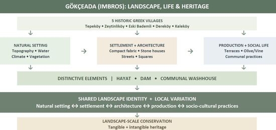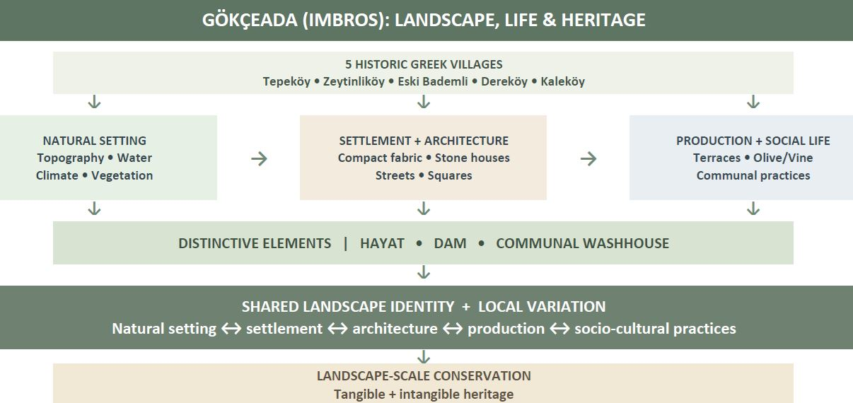
Entry

Characteristics of the Rural Cultural Landscape in Gökçeada (Imbros)

Faculty of Architecture, Istanbul Aydin University, 34295 Istanbul, Türkiye
Encyclopedia 2026, 6(10), 208; https://doi.org/10.3390/encyclopedia6100208
Submission received: 17 August 2026 / Revised: 18 September 2026 / Accepted: 18 September 2026 / Published: 23 September 2026
(This article belongs to the Section Social Sciences)

Definition

Rural cultural landscapes are shaped by the long-term interaction between natural environmental conditions and human activities, reflecting local settlement patterns, architectural traditions, production practices, and socio-cultural values. The rural cultural landscape of Gökçeada (Imbros) is represented particularly by its five historic Orthodox Christian Greek villages—Tepeköy (Agridia), Zeytinliköy (Aya Todori), Eski Bademli (Gliki), Dereköy (Skinudi), and Kaleköy (Kastro). Their landscape character is defined by the interrelationship between the island’s natural setting, compact hillside settlements, vernacular stone architecture, agricultural and productive landscapes, public and communal spaces, and continuing socio-cultural practices.

Graphical Abstract

1. Introduction

1.1. Theoretical Perspective

Rural areas are generally living spaces in which lifestyles depend on traditional practices that have been shaped by the local topography and climate, local living conditions, and the regional economy. Rural settlements are the basic components that comprise the foundation of rural living. The rural landscape provides an integrated framework for the rural area and represents an entire system that includes areas of agricultural utilization, transportation networks, and natural resources [1].
Rural settlements are identified by the character of the landscape in which they are located, and each rural settlement has its own system of social relations and traditions according to its geographical location [2]. Each rural settlement has its own dynamics and displays differences from other settlements. The most significant indicator of these differences is how the identity of the landscape is defined. The identity of a landscape is, by its nature, defined by its own characteristics and its relationship with the environment [3].
Areas belonging to a rural landscape are sources that provide fields of exploration and implementation for understanding the cultural landscape. Cultural landscapes are areas in which human societies and settlements flourish over time under the influence of social, economic, and cultural forces dictated by the opportunities or restrictions imposed by the natural environment [4]. The International Union for Conservation of Nature (IUCN) defines a cultural landscape as a geographical area that emerges as a result of the interaction between people and the natural environment, gains importance over time, and exhibits diverse natural, cultural, and visual values [5].
The cultural landscape comprises areas that reflect the interaction between human beings and nature. The European Landscape Convention, adopted in 2000, defines the cultural landscape as “an area whose character is the result of the action and interaction of natural and/or human factors” [6]. UNESCO classifies cultural landscapes into three main categories: man-designed and created cultural landscapes, organically evolved landscapes that develop in relation to and in response to the natural environment, and associative cultural landscapes with strong religious, artistic, or cultural ties [5].
Within this conceptual framework, the rural cultural landscape of Gökçeada can be interpreted as corresponding most closely to an organically evolved landscape, specifically its continuing landscape subcategory. According to UNESCO, organically evolved landscapes develop through association with and in response to their natural environment, while continuing landscapes retain an active social role in contemporary society and exhibit material evidence of their evolution over time [7]. In the case of Gökçeada, the adaptation of the historic villages to sloping topography, together with agricultural terraces, vineyards, olive groves, vernacular stone architecture, and structures associated with rural production, demonstrates the long-term relationship between environmental conditions, settlement, and agricultural production [6,8,9]. The continued presence of agricultural activities, religious practices, communal spaces, and local traditions further indicates that elements of the historical relationship between community and landscape remain active, although demographic transformation, abandonment, and changes in traditional production have weakened some aspects of this continuity [8,10]. On the basis of these characteristics, the UNESCO category is used here as an analytical framework for interpreting the evolutionary and continuing character of Gökçeada’s rural landscape rather than as an assertion of formal World Heritage status.
The concept of preserving the character of a rural landscape changed with the adoption of the World Heritage Convention and the European Landscape Convention [11], bringing to the fore the notion that landscape must be assessed within the framework of international policy [1]. In the “Principles Concerning Rural Landscapes as Heritage” drawn up by the joint committee known as the ICOMOS-IFLA International Scientific Committee on Cultural Landscapes, while attention is focused on the concept of rural landscape heritage, the dangers that can cause alterations in rural areas and in the landscape are also underlined [8].
The geographical location, topography, hydrology, production landscape, wildlife, and other factors define the landscape identity of each rural settlement. Landscape identity displays variability in each settlement. The rural cultural landscape, which represents the environment that is the product of the activities of nature, is divided into natural and cultural landscapes [12]. The components of the first of these landscapes, natural rural landscapes, are made up of topography, climate, geology, water sources, vegetation, and wildlife. The other rural landscape, the cultural landscape, encompasses the settlement’s physical structure, its architectural character, the construction materials that have been used, the elements making up the streets and the landscape as a whole, the vegetation in the area, and the type of production undertaken [2].
Throughout Anatolia, there are rural cultural landscapes that not only reflect the physical state, topography, climate, vegetation, and materials used in the particular region but also carry evidence of social and cultural values, the historical background, and other local and regional characteristics of the area. One of these landscapes was referred to in the Age of Antiquity as “Imbros.” This island, now known as Gökçeada (İmroz in Turkish), is situated 20 km off the Biga Peninsula, to the north of the Aegean valley. As Turkey’s largest island, Gökçeada (Imbros) is characterized by villages that carry the identity of the rural landscape.
International studies of rural cultural landscapes increasingly emphasize integrated approaches that consider environmental conditions, land use, traditional production systems, and cultural heritage as interrelated components of landscape character. In the Mediterranean literature, for example, multidisciplinary approaches have been developed for identifying and characterizing traditional cultural landscapes through the combined assessment of environmental conditions, land-use patterns, traditional agroforestry systems, land-management practices, and heritage features [4]. Agricultural terraces constitute another important component of this literature. Terraced landscapes have been interpreted through the combined analysis of their structural, biophysical, cultural-historical, and agricultural characteristics [13]. Mediterranean terraced landscapes have also been approached as coupled human–environment systems whose continuity is closely related to the maintenance of traditional agricultural practices [14]. Although Gökçeada is geographically situated in the North Aegean, these studies provide a broader comparative and methodological framework for examining the relationships among topography, agricultural production, settlement, and cultural landscape character. Recent research has further emphasized the social–ecological character of rural cultural landscapes, demonstrating that their conservation depends not only on the protection of physical landscape components but also on the continuity of traditional land-use practices and the socio-economic systems that sustain them [15]. Studies on traditional villages also stress that the preservation of rural architectural heritage should be integrated with the continuing development and use of rural settlements rather than approached solely through the conservation of individual historic buildings [16]. In addition, integrated approaches combining landscape characterization with local knowledge and temporal land-use analysis have proved valuable for understanding the historical development, heritage significance, and future sustainability of rural landscapes [17].
Previous studies on Gökçeada have examined different dimensions of the island and its traditional settlements, including settlement geography and historical development [6], architectural heritage and building typologies [18,19], and the conservation of rural architectural heritage within the historic rural landscape of Zeytinliköy [9]. However, a comparative and integrated assessment of the five historic Greek villages that simultaneously considers their natural environment, settlement morphology, vernacular architecture, productive landscapes, socio-cultural practices, and conservation issues remains limited. This study addresses this gap by applying an integrated rural analysis approach to Tepeköy (Agridia), Zeytinliköy (Aya Todori), Eski Bademli (Gliki), Dereköy (Skinudi), and Kaleköy (Kastro), thereby identifying both their shared and village-specific characteristics and revealing the interrelationships through which these components collectively shape the distinctive rural cultural landscape of Gökçeada.
Accordingly, this study examines these five historic Greek villages through an integrated assessment of their physical environment, topography, climate, locally available materials, vegetation, settlement patterns, vernacular residential and public architecture, cultural structures and traditions, and traditional production practices. Through this assessment, the study aims to identify the natural and cultural components that constitute the rural landscape character of these settlements and to evaluate how their interaction contributes to the distinctive rural cultural landscape and rural heritage of Gökçeada.
The study employs a qualitative rural landscape analysis based on field observations conducted in September 2023 and a review of the relevant literature. The five historic Greek villages—Tepeköy (Agridia), Zeytinliköy (Aya Todori), Eski Bademli (Gliki), Dereköy (Skinudi), and Kaleköy (Kastro)—were selected because they represent the historic Greek Orthodox village settlements examined in this study and retain identifiable components of Gökçeada’s traditional rural landscape. Planned settlements established primarily from the 1960s onward were excluded because the study focuses specifically on the historically evolved rural landscape of these five traditional villages. The villages were examined through seven interrelated analytical dimensions: natural environment, settlement characteristics, architectural characteristics, socio-cultural characteristics, economic activities, landscape character, and conservation issues. Field observations focused on the natural and built characteristics of the settlements, including settlement morphology, streets and squares, vernacular residential architecture, public and religious buildings, structures associated with agricultural production, and productive landscape elements. These observations were considered together with socio-cultural practices and traditional production activities documented in the relevant literature in order to examine the relationships between tangible and intangible components of the rural cultural landscape. The characteristics identified through fieldwork and the literature were subsequently organized into a qualitative comparative framework across the five villages to identify shared landscape components and village-specific variations.
The fieldwork was designed as a qualitative landscape-character assessment rather than as a comprehensive numerical inventory; therefore, total counts of houses, streets, squares, churches, washhouses, mills, and dam structures were not recorded. No separate standardized building-recording form was employed; observations were structured according to the analytical dimensions of the rural analysis framework presented in the Supplementary Materials (Tables S1 and S2). No formal interviews were conducted, and interview data were not used as a research dataset; accordingly, informed consent was not applicable. The fieldwork did not include systematic GIS-based mapping or comprehensive measured surveys of individual buildings. Architectural plans and sections reproduced in the entry derive from previously published documentation and are identified as adapted or reprinted in the relevant figure captions. Detailed research questions and analytical components of the rural analysis method are provided in the Supplementary Materials (Tables S1 and S2).

1.2. Historical Background

Known as “Imbros” in Antiquity, Gökçeada’s history dates back to the Early Bronze Age [20]. The name “Imbros” derives from Imbrasos, accepted as the god of abundance who ruled over arid lands [21].
Data on the prehistoric period of the island and its geography were uncovered in the Yeni Bademli Höyük excavations. The archeological digs at the höyük (tumulus) revealed that this land could be dated to 3000–2000 BCE [22]. Level I of the site goes back to the first half of the third millennium BCE, and the architectural ruins found at the flatland on the mound point to extensive settlement in the area. With most of the structures revealing a rectangular plan, the building materials used in the site are stone, mudbrick, and timber construction that was used for supporting the walls [22]. Besides the stand-alone buildings in the settlement, there are also structures that were built in the form of adjacent blocks. The buildings were predominantly used for housing, and among the immovables found inside these structures were round and oval simple hearths encircled with gathered stones, kilns in the form of horseshoes, and a platform built of small stones [20].
In the Classical Period, the island surrendered to the Persians in 512 BCE. While in the 500s BCE the island was administered by the city-state of Athens, in the Roman Era, the area of settlement shifted to the region of Aydıncık. The rock tombs at Kokian uncovered on the island belong to this latter period. In the time of the Romans, Kaleköy, which was one of the territories outside of the city-state that paid taxes to Rome, and Eski Bademli were the significant seats of settlement in this period [6].
Known today as Yukarı Kaleköy (Kastro), this district reveals evidence of Byzantine settlement. An acropolis surrounded by walls built in the time of the Byzantines stands at the top of the hill. İmbroz (Imbros), which lies close to Kaleköy and lends its name to the island, was one of the most important cities of the ancient settlement [6].
In recent years of the Byzantine Era, the island was administered by the Genoese and the Venetians. The largest district settled by these maritime republics is Kaleköy, which looks over the port. The island was of great commercial importance to the Venetians in the fifteenth century. When Venice and Genoa lost their superiority in maritime trade, the island passed into the hands of the Ottomans [6]. By the time of the Rhodes expedition in 1470, the island had come completely under the control of the Ottomans. The island earned the designation of a Foundation (Wakf) in 1556 and saw the establishment of new settlements. By the end of the 16th century, its population had risen to close to 5000 [23]. After the Balkan War defeat in 1912, the island passed into the domination of Greece, and in 1923, as per the provision granted in the Lausanne Peace Treaty, it was annexed to Turkey. Its name remained İmroz (Imbros) until 1970, when it was changed to Gökçeada by decree of the Cabinet of Ministers [23].
The island was awarded the “Cittaslow” (slow town) title in 2011, becoming the world’s first and only “slow town” island. Today, there are ten village settlements on the island outside of the center of town. Of these, Tepeköy (Agridia), Zeytinliköy (Aya Todori), Eski Bademli (Gliki), Dereköy (Skinudi) and Kaleköy (Kastro) are Greek Orthodox settlements, while Uğurlu, Yeni Bademli, Şirinköy and Eşelek are planned settlements established by the Turkish state beginning in the 1960s. Today, the population of the island includes both Greek and Turkish communities.

2. Characteristics of the Rural Cultural Landscape

2.1. Rural Landscape Components

Rural settlements have two types of rural landscape components: natural and cultural landscape elements. Geographic location, topography, hydrology, vegetation, and wildlife determine the natural landscape features, while street patterns, houses, religious structures, production facilities, and traditions and socio-economic conditions constitute the cultural landscape components.

2.1.1. Natural Rural Landscape Components

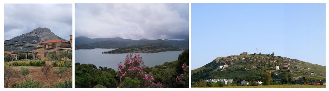
Outside of the center of town, the island has a rural character. Topographically, its rural villages are hillside settlements (Figure 1). These were established inland, away from the coast [23]. The distribution of the villages conforms to the topography of the terrain. The villages are accessed via a trek up the hillside. They are positioned on the slopes overlooking the arable and productive land below. Most of the villages are situated in the northeastern part of the island, on the hillsides overlooking Büyükdere Valley. Rather than settling along the coasts, the island villages surrounding the most arable land were built on the high hills looking over the plains. Only the village of Kaleköy lies close to the coastline [23].
The island is rich in water sources; its freshwater sources are mostly situated inland. Büyükdere, Güllüdere, Tokludere, and Değirmendere are the island’s major tributaries [6]. Outside of these, the island has a wealth of ponds and dams (Figure 1: Middle). There are five ponds on the island. The Zeytinliköy Dam provides a good portion of the island’s need for potable water and water for irrigation. Lake Tuz (Salt) is a considerably shallow body of water used for both health tourism and as a recreational site.
The island has a Mediterranean climate. Annual precipitation is 745.4 mm, with 48.6% of this falling in the winter months. The annual average temperature is 14.60 °C [6]. The dominating winds on the island are southwesterly and northwesterly. Topographically mountainous and hilly, the island’s villages are scattered with maquis shrubland, a common vegetation in the Mediterranean region. Along the streams can be found oleander and chaste trees, types of maquis [8]. Sprinkled amid these are some poplars and pine trees. On the climb from the base of the valley toward the slopes, evergreen oaks and thyme can be seen [24]. Arşi (Arassia), the island’s most prominent mountain, has natural water springs and overlooks the Zeytinliköy landscape [9]. (Figure 1; Left).

2.1.2. Cultural Rural Landscape Components

Settlement Pattern and Spatial Organization
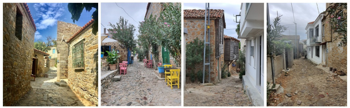
Although the villages have been established on sloping land, they are compact and laid out on a defined plan [25]. The stone-covered streets of the island villages are well suited to the topography, have been developed organically, and comprise a tightly woven settlement (Figure 2). The houses are close together. The streets, narrow and occupied by various village buildings, have been laid out on an incline to facilitate the flow of rainwater (Figure 2). The narrow streets, as well as the balconies that overlook the streets and the oriel windows, all characterize the villages. The distances between the streets have been calculated so as to allow two load-carrying mules to pass by side by side.
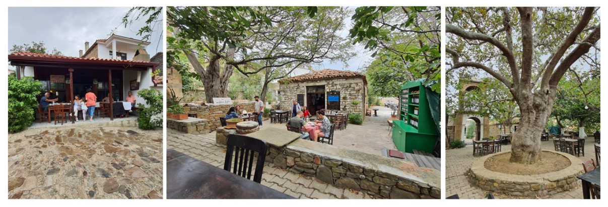
Every village has a small village square of its own. An ancient oak or mulberry tree is the landmark of the square. Its most significant structure is the coffeehouse. The coffeehouse serves a very special ground coffee (dibek kahvesi) that is unique to the island (Figure 3).
The vegetation on the island features olive trees, almond trees, oleander, pomegranates, Evening Pleasure flowers, and chrysanthemums. Almost every garden and street boasts oleander, pomegranates, and Evening Pleasure (Figure 4).
Vernacular Residential Architecture
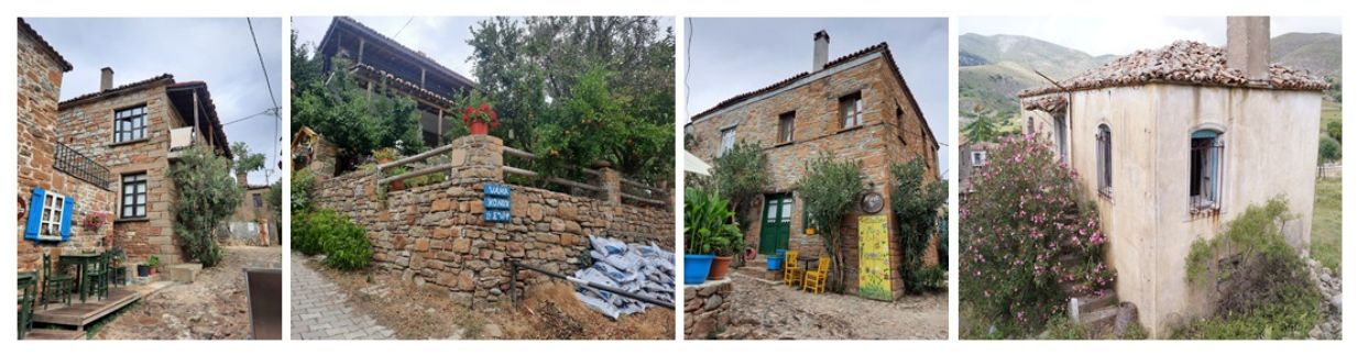
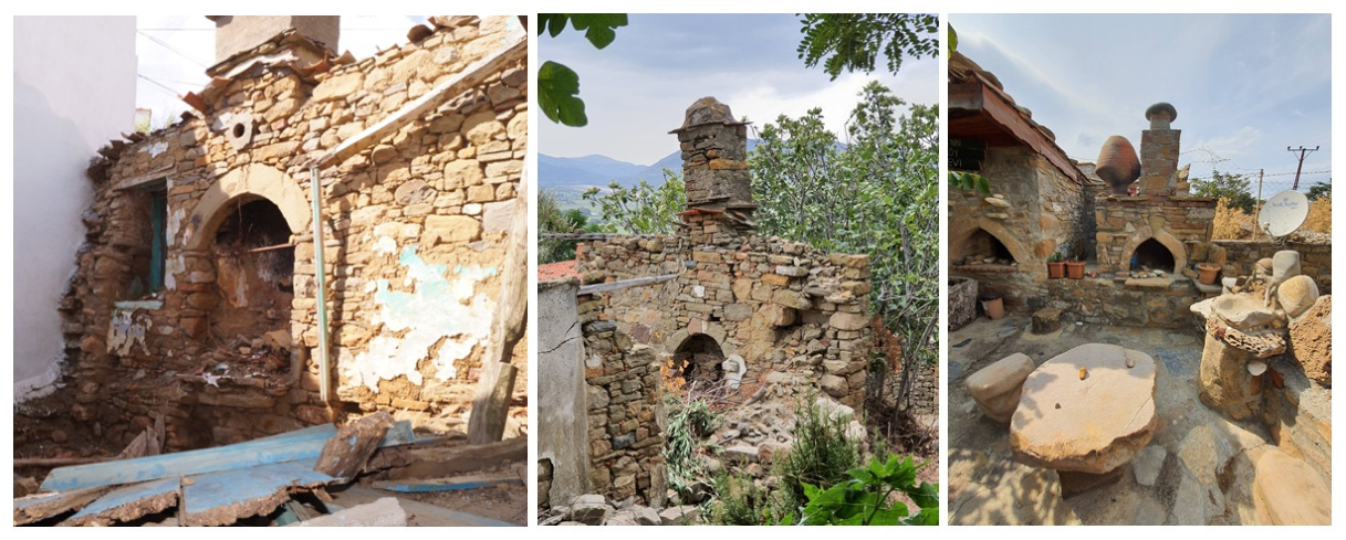
Houses are among the most prominent features of the rural landscape of the villages (Figure 5). The houses have been situated on inclining land so that they do not block each other’s sun [25]. The island houses are quite simply built and functional; they are two-storied structures with courtyards. The houses in this agricultural and stockbreeding district have barns and storage spaces on their lower floors [19]. The upper floors are the living spaces and consist of a simple plan of one or two rooms with a door leading directly into the courtyard. The houses generally include courtyards that function as important extensions of domestic and productive life, where food is cooked, bread is baked, fruits are dried, animals are tended, and other daily activities are carried out [22]. Daily tasks are also performed on the platform on the upper floor, in the space called “hayat.” In one corner of the courtyard, there are semi-closed sheds where various materials are piled up and where animals are tied. There is always a hearth in the courtyard (Figure 6: Right). The courtyards are surrounded by a high wall, and there is a door leading outside that is wide enough to let animals through [25].
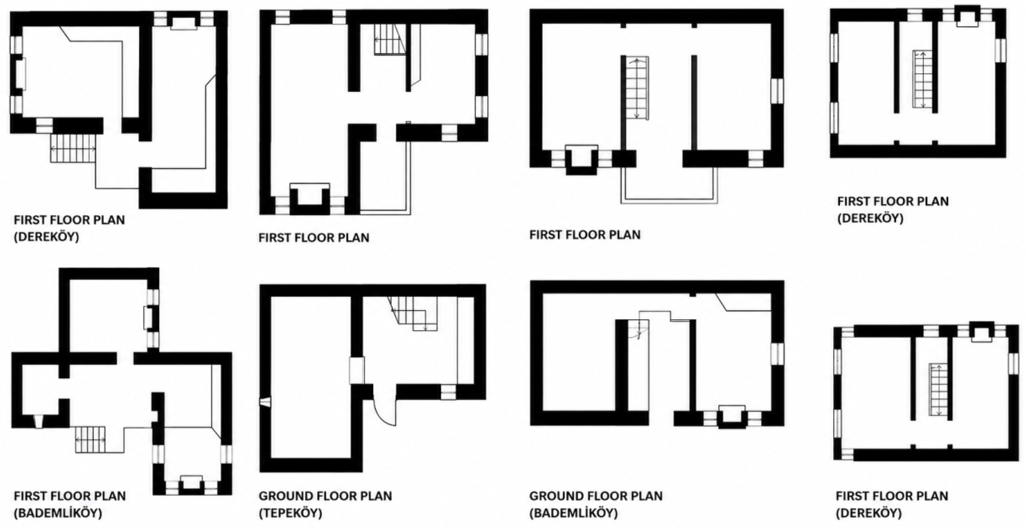
The simplest of the types of houses are in two-story rectangular form, set up on a single-space plan [18]. There are also among the plan types those that have annexed a second single-space structure that shares the same landing or applications where the hayat has been closed off for privacy and the stairs have been placed inside the structure (Figure 7).
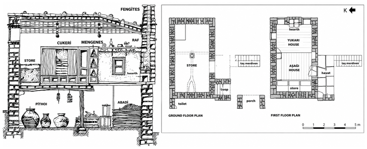
The houses consist of a ground floor that opens out into the courtyard and an upper floor that has been arranged as the “real house” (esas ev). In the oldest of the island houses, both floors consist of a single room–these are called “single houses” (tek evler) [19]. The hearths are the most noticeable of the living spaces (Figure 6: Left). In one corner of the ground floor, used as a storage space, there are wooden granaries called abadi in which the harvest of olives is stored (Figure 8: Left). Earthenware jars are buried along the edges of the walls to store wine and olive oil (Figure 8: Left). Besides these, this area also houses dry goods, firewood, and animal feed [18].
Access to the upper floor that the island folk have named the “real house” (esas ev) is from stone steps leading up from the outside of the house. The landing in front of the door at the top of the stairs is called “hayat” [19]. Some daily activities are carried out not only in the courtyard but also in the “hayat.” In the traditional residential architecture of Gökçeada, the hayat is an open or semi-open courtyard/porch space where the house connects with the outside environment and where daily production activities, social interactions, and domestic tasks take place. Usually enclosed by stone walls, the hayat separates the house from the street and provides the family with a private living space. Unlike the term hayat in traditional Turkish domestic architecture, which generally refers to an open gallery or sofa, in Gökçeada houses the hayat functions as an open or semi-open transitional space associated with the entrance to the upper-floor living area, connecting the dwelling with the courtyard and ancillary spaces [27]. The hayat also functions as a domestic extension of the island’s principal rural livelihoods, particularly olive cultivation, viticulture, and animal husbandry. Agricultural products brought from the fields or vineyards, such as grapes, olives, and grain, are sorted and processed in this space before being transferred to storage areas (ambar) on the ground floor. A fireplace or hearth is an essential feature of the hayat, and bread is also baked in this space [28]. In some houses, one end of the hayat was enclosed to create an additional space. This small space was used for activities associated with the daily tasks carried out in the hayat. There are also examples in which the entire hayat was enclosed with wooden planks to provide greater privacy [8].
The upper floor consists of a single space and is divided into two by means of a platform (seki). The part of the space with the platform, which is at about the height of one stair step, is known as the “upper house” (yukarı ev), and the space below is called the “lower house” (aşağı ev) [26]. (Figure 8: Right). The upper house (yukarı ev) is where the family sits, eats, and sleeps. This part of the house usually has a hearth. Above the hearth are shelves that run along the walls. The windows illuminate the space and are usually placed on the two sides of the hearth. Below the platform, or seki, the part of the structure called the “lower house” (aşağı ev) is the space accessed by the entrance. On one side of this part of the house are granaries where grains are stored; there are closets called “gukeri” on the other side [19].
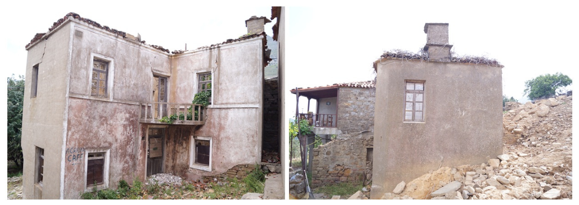
According to island customs, a girl who is to be married is given the “real house” (esas ev) as a dowry by her family. The family then builds a new house adjacent to the other one. This new house is called “yeriko” (old folks’ house) [18]. This way, an L-shaped “double house” that shares the same courtyard comes into being (Figure 9). Using the same landing, accessed from some stone stairs, the interior of the houses is arranged as in the single-space houses.
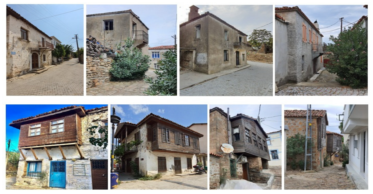
With time, the houses went through various changes. The stairs leading upstairs were brought inside, creating direct access between the floors. Also, a part of the lower floor was now arranged as living space. The landing of the old stairs was used as a balcony [18]. (Figure 10: Above). Thus, the balconies were turned into closed spaces and, as projections, supported by consoles from underneath. In one group of houses, these balconies were replaced by wooden oriel windows that covered the entire space of one wall in the room. These oriel windows are reminiscent of the oriel windows of the traditional Turkish house; they are supported by wooden buttresses (Figure 10: Below). To meet developing needs in later periods, the number of rooms was increased, the dimensions of the house were expanded, and courtyards were eliminated, turning the houses into structures that opened out directly into the street.
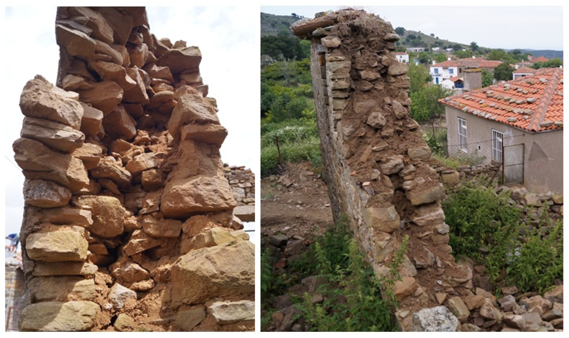
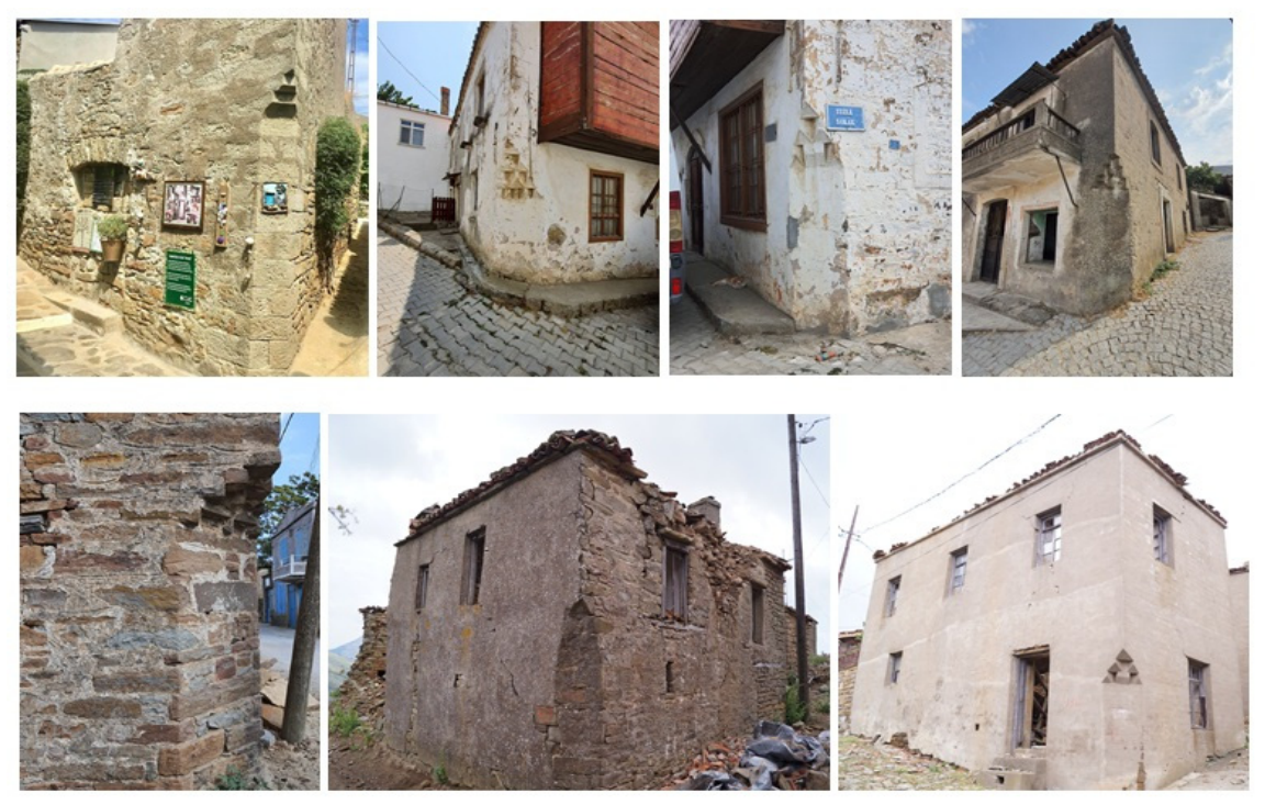
The houses were constructed using a masonry system. As building materials, they made use of local andesite, sandstone, and other regional rocks and stones. The walls were built in the stone masonry system with mortar made of a mixture of mud and grass or lime and sand [29]. It was only in recent times that cement mortar was used in building the walls of the houses. There are also a few examples of walls built in the dry-wall technique. With an average thickness of 50 cm, the interiors and exteriors of the walls contained medium-sized rubble stone, while smaller stones and earth fill were used in the core of the walls (Figure 11).
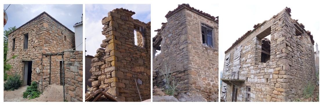
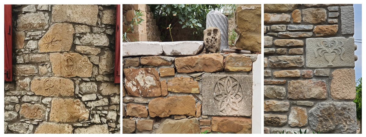
This kind of wall-building system is called a double stone wall (sandık duvar) [29]. Larger stones were used at the corners of the walls (cushion stone wall) (Figure 12). Sometimes these cornerstones are laid out in alternate pattern, with one row of large and one row of small stones on top of each other. This type of masonry pattern used in the houses is characteristic of the region. Spolia materials used in Byzantine structures can also be seen in the masonry (Figure 13).
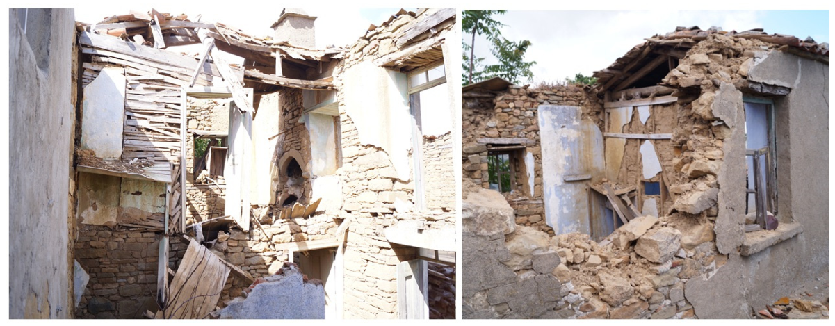
Timber was also used as a finishing touch to the architectural construction of the houses. Wood was utilized as a construction material in floors, roofs, and interior walls. The interior wall sections are made of a brick- or mudbrick-filled wooden frame and bağdadi plaster (Figure 14). Doors and lintels are also usually made of wood.
In some of the houses, at the point where the ground floor meets the street, beveled corners (pah) in straight muqarnas form can be seen at the corners of the wall to ease passage (Figure 15). This beveling tones down the sharp corners (blinding) and is part of the facade characteristics of the island houses.
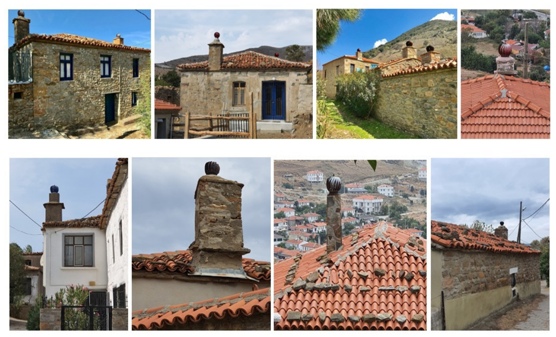
The roofing system of the island houses is in the form of hipped and gabled roofs. There are various types of chimneys on the roofs. The most commonly used types of chimneys in island houses are open brick-covered chimneys and chimneys with rotating weathervanes. The weathervane chimneys, operating on wind power, are important elements of the rural landscape. The rotating weathervane chimneys respond to wind direction and facilitate the discharge of smoke and indoor air through the chimney [30,31] (Figure 16).
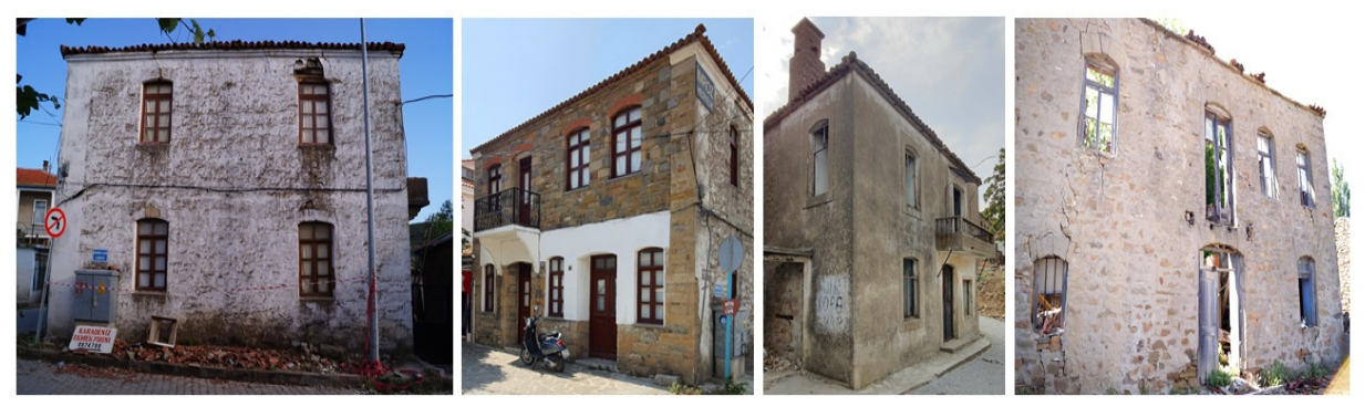
Windows, balconies, oriels, and wall textures are the most striking features shaping the facades of the houses. Walls are plastered with a mixture of concrete in some houses, and sometimes with lime. The cornerstones, spolia, and beveled corners are the other materials forming the texture of the facades. Some of the characteristic windows have plain wooden or concrete lintels, while others have flat, rounded arches built of brick (Figure 17). Similarly, while some doors are framed with plain concrete lintels, sometimes they too have flat, rounded arches built of brick (Figure 17). The chimneys, which are visible from the front of the house, constitute another element forming the facade. The stair landings, balconies, oriels, and supporting wooden buttresses are other features shaping the facade.
Productive Landscape and Traditional Production Structures
Another cultural component of the rural landscape that can be found in every Gökçeada village is what is called “dam.” The “dam” is a country cottage built near the cultivated fields where the island villagers settle in the summer months when fieldwork is at its peak [26]. If a family is also engaged in animal husbandry, livestock are kept in the “dam” rather than in the village [32]. These structures are generally seen throughout the island and especially toward the south and north of the route connecting Kaleköy and Dereköy. The “dam” structures were built on the cultivated lands of each village and occur either as isolated buildings or in small clusters [25]. These temporary settlements were arranged informally, and some of the structures have subsequently been converted into permanent dwellings. In the past, the “dam” structures on the island were situated on terraces on the hillsides, lending themselves to viniculture and olive cultivation. The “dam” structures appear either as a single house or a cluster of 15–20 houses, built haphazardly on auxiliary areas of cultivation [6]. Today, many of these buildings are dilapidated, but those that are in good shape are being used for feed storage and sheltering animals. The buildings act as temporary rural housing, are usually single-story, built on a base of local stone and made of masonry. They are covered by gabled roofs. There are, however, some two-storied buildings. Structurally, the “dam” resembles an ordinary house. The general layout comprises one room where the family can stay and has an adjacent space that is used as a barn and hayloft [4]. There are examples where the main living space is divided into three rooms, including a storage room and a barn, as well as those buildings with only one room where villagers and their animals live together in the same space [25]. Some of the structures have a hearth inside. The room containing the fireplace accommodates a range of domestic activities, including eating, drinking, daily living, resting, and sleeping. In some examples, a porch supported by wooden posts extends along the front of the building, providing a sheltered semi-open space. There are also cases in which closely grouped “dam” structures do not each have their own fireplace. In such cases, a fireplace is used communally for cooking, and the owner of the fireplace traditionally receives a share of the food prepared there [19]. Not every family living on the island owns a “dam”, while some families may possess more than one [33]. In this respect, “dam” structures form an integral part of the rural production system.
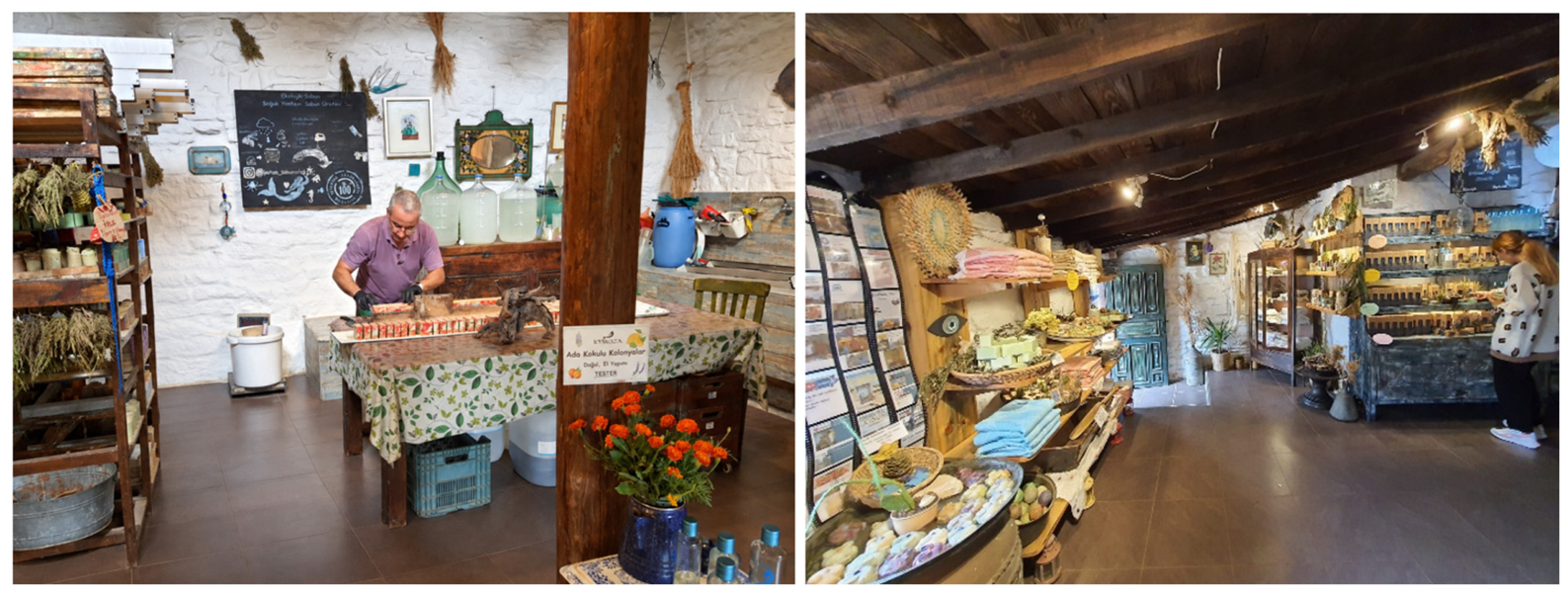
Other features of the island’s rural landscape are buildings housing production areas. Fishing, sponge fishing, and maritime trade have traditionally been important economic activities on the island. Viniculture and olive-growing take place along the terraces on the island hillsides [6]. Local manufacture on the island includes olive oil, soap, weaving, kashar cheese, and carpentry. The island villages all have workshops for the different trades, signs of developed artisanship (Figure 18). The manufacture of olive oil and soap on the island continues to thrive, reflecting a cultural tradition. There are large jars of olive oil on the streets and in the courtyards of every village on the island.
Windmills and waterwheels were characteristic elements of the island’s rural cultural landscape and were historically used in flour and olive-oil production. Although no intact example has survived on the island, their former architectural characteristics can be identified through historical photographic documentation [19].
Public and Communal Buildings
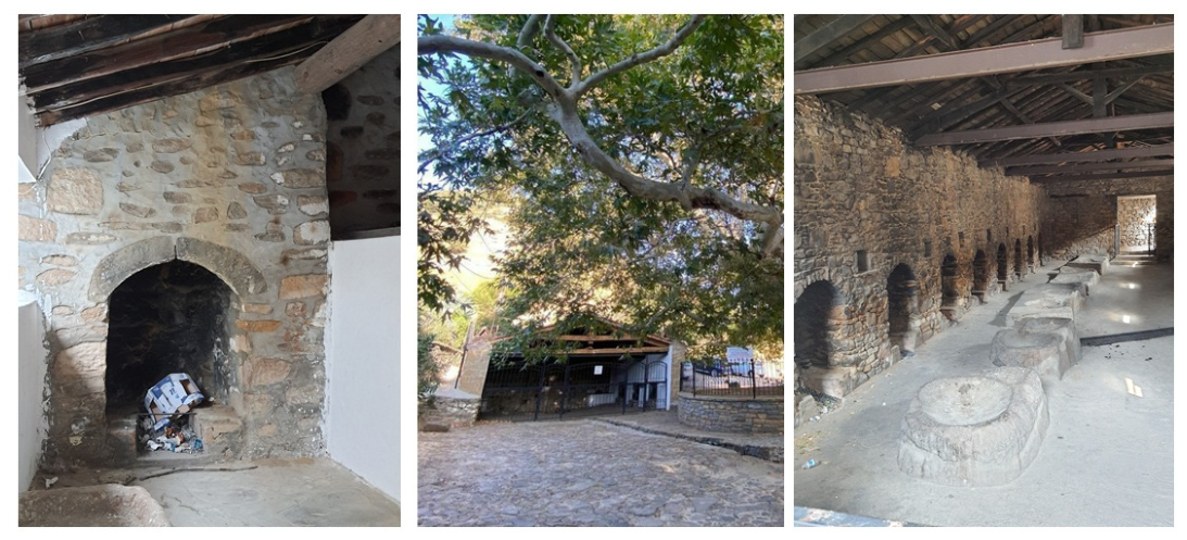
Another characteristic of the rural landscape of the island villages is the washhouse, which has become a prominent feature of every village. With at least one washhouse in every village, these buildings are situated in an area close to the village square or church. The washhouse adjacent to Hagia Marina Church in Dereköy is particularly of note; measuring 18 × 6 m, it is a monumental example of this island tradition [26] (Figure 19: Right). Washhouses, which constitute an important part of the island’s social life, are formed by enclosing and roofing over fountains [8]. These structures are long rectangular buildings with one side closed or left open. Covered with gabled roofs, the building contains basins, hearths to heat water with washbasins standing in front, platforms, niches where supplies are kept, and water channels (Figure 19). According to previous documentation, each village traditionally had a designated washing day, during which women gathered at the washhouse not only to do laundry but also to socialize [8]. These spaces also serve as places for social interaction and are used for various special and religious occasions. During religious festivals, sacrificial meat is cooked in the hearths of the washhouses and distributed among members of the local community. Still used during religious festivals and on special occasions today, the washhouses continue to constitute an important part of the island’s social life [8].
Religious Architecture
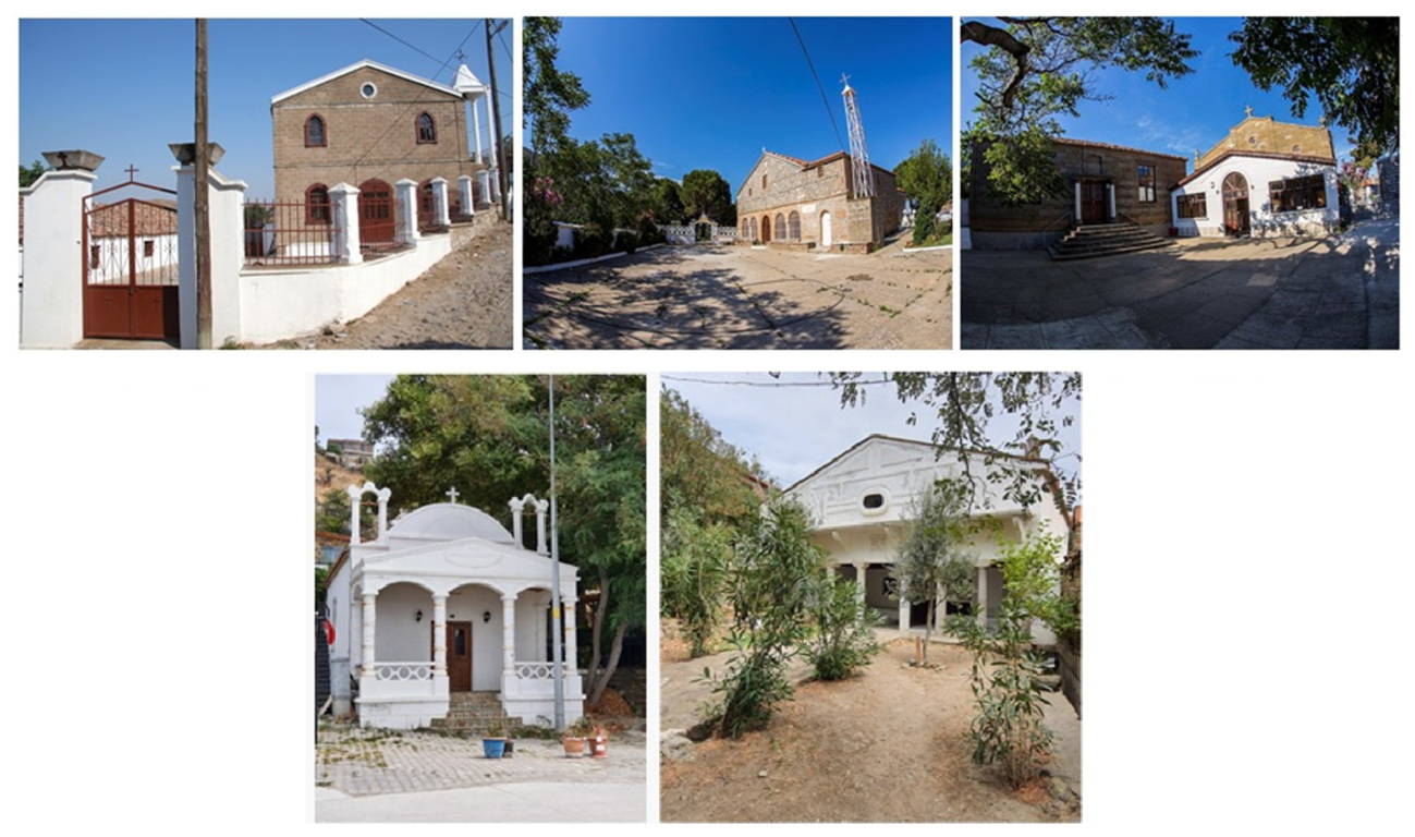
Another important element of Gökçeada’s rural cultural landscape is its religious architecture, which is an important part of daily life on the island (Figure 20). Every village has at least one Orthodox church and chapel that belong to the settlers of Christian Greek origin. There are eleven churches throughout the island [24]. These churches have been built on a traditional basilica layout with one or two naves. They are generally surrounded by many chapels that have been positioned in the vicinity of cultivated land [24]. The chapels are of smaller size. In the island village of Tepeköy, August 15 is celebrated as Annunciation Day, which continues for 10 more days. In this period, Tepeköy’s Greek descendants are joined in the festivities by Turkish tourists. Large cauldrons are set up to make and distribute keşkek (a dish of meat and wheat), while people dance and drink their wine.

2.1.3. Demographic Transformation, Threats, and Conservation Potentials

In addition to their natural, spatial, architectural, and socio-cultural characteristics, the traditional villages of Gökçeada have undergone substantial transformations associated with demographic change and the decline of traditional patterns of use. Particularly during the twentieth century, changes in the demographic structure of the island affected everyday life, agricultural production, traditional craftsmanship, and the use and maintenance of the built environment [10]. The decline of the Greek population altered the demographic and cultural context in which the historic villages had developed.
The demographic transformation of Gökçeada should be understood within the specific historical circumstances of the twentieth century. Although the Greek Orthodox inhabitants of Imbros were exempted from the compulsory population exchange between Greece and Turkey following the Treaty of Lausanne in 1923 [34], the demographic structure of the island changed substantially during the following decades. This transformation accelerated particularly after 1964, in the context of renewed political tensions between Turkey and Greece and the broader pressures affecting the Greek population of Turkey. On Gökçeada, changes in land ownership and use, expropriations, the establishment of new state institutions, and related socio-political conditions contributed to the increasing outward migration of the island’s Greek population during the 1960s and subsequent decades [10,34,35]. During the following decades, planned settlement policies brought populations from different regions of Anatolia to Gökçeada, and new settlements were established alongside the historic villages [35]. These interconnected processes altered not only the demographic composition of the island but also patterns of land use, agricultural production, and the continuity of traditional settlement life. Consequently, the abandonment and deterioration observed in parts of the historic built environment should be understood not simply as a generic process of rural decline, but in relation to these wider demographic and socio-political transformations.
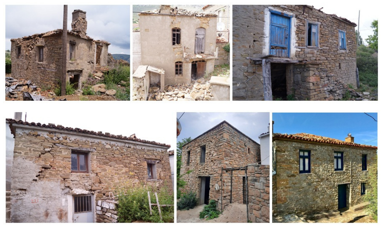
One of the most visible consequences of this process is the abandonment and physical deterioration of traditional buildings. A number of vernacular houses and structures associated with rural production have lost their original functions or remained unused. Houses, workshops, olive presses, mills, and other production-related structures display different degrees of deterioration resulting from loss of use and lack of maintenance. Because these structures form part of the wider settlement fabric together with streets, village squares, churches, coffeehouses, and communal washhouses, their loss also changes the physical composition of the traditional villages.
Changes are also evident in the productive landscape. Viticulture, olive cultivation, local craftsmanship, milling, and seasonal agricultural practices historically shaped both everyday life and the physical environment of the settlements. Agricultural terraces, vineyards, olive groves, workshops, mills, and related structures remain material evidence of these activities, although some have lost or changed their original functions. Their survival documents the historical relationship between settlement, agricultural production, and local ways of life.
Despite these transformations, many characteristic components of the traditional rural landscape remain identifiable, including compact hillside settlement patterns, narrow stone-paved streets, village squares, vernacular houses, churches, coffeehouses, communal washhouses, agricultural terraces, olive groves, vineyards, and other productive landscape elements. The surviving vernacular building stock, characterized by local stone, traditional masonry techniques, timber elements, tiled roofs, courtyards, balconies, oriel windows, and hearths, continues to provide evidence of local construction knowledge and traditional ways of life.
Conservation potential is also associated with the persistence of cultural and productive practices. Olive cultivation, viticulture, local craftsmanship, religious traditions, communal gathering practices, and the continued social use of village squares and coffeehouses maintain links between the physical environment and the cultural practices historically associated with it. Together, the surviving built, productive, and socio-cultural components provide the material and cultural basis for the conservation and continuity of Gökçeada’s traditional rural cultural landscape.
The conservation of Gökçeada’s historic rural landscape should build upon the existing statutory protection framework while extending its scope beyond individual buildings to encompass settlement fabric, productive landscapes, and associated cultural practices. Several of the historic villages, including Tepeköy, Zeytinliköy, Eski Bademli, and Dereköy, are subject to urban conservation-site protection, while individual buildings and other cultural properties are also protected through registration decisions [36]. Within the existing national framework, documentation and conservation interventions for registered cultural properties are implemented through projects approved by the relevant Conservation Regional Board, including survey and restoration projects and, where required, restitution documentation [37]. However, effective conservation at the rural landscape scale requires these statutory instruments to be complemented by coordinated management measures addressing vernacular buildings, streets and squares, agricultural terraces, vineyards, olive groves, production structures, and continuing socio-cultural practices as interconnected components of the same heritage system. Adaptive reuse should be encouraged for abandoned or underused vernacular houses and production-related structures where new functions can be introduced without compromising their architectural character and historical relationship with the settlement and productive landscape. Recent research in Türkiye similarly indicates that the conservation and compatible reuse of rural architectural heritage can contribute to the continuity of local cultural values while supporting sustainable rural development [38]. Existing financial mechanisms under national heritage legislation provide project and implementation assistance for privately owned registered cultural properties, including financial, technical, and in-kind support [37]. These mechanisms can support maintenance and restoration, while additional locally targeted incentives could encourage owners to retain traditional materials, construction techniques, and compatible uses. Implementation requires coordination among the Ministry of Culture and Tourism and the relevant Conservation Regional Board, Gökçeada Municipality, relevant provincial authorities, property owners, and local communities. Such an integrated approach would shift conservation from the protection of isolated monuments toward the coordinated management of Gökçeada’s rural cultural landscape as a whole.

3. Discussion

3.1. Integrated Assessment of the Rural Cultural Landscape

The findings indicate that the distinctive rural character of Gökçeada’s Greek Orthodox villages cannot be attributed to a single environmental, architectural, or cultural factor. It has developed through the interaction of natural conditions, settlement patterns, vernacular architecture, productive activities, and socio-cultural practices. Natural conditions influenced the location and development of the settlements, while local ways of building, producing, and living gave these settings their cultural character.
The relationship between topography and settlement form is particularly significant. The location of the villages on sloping terrain overlooking productive agricultural areas shows that settlement patterns were closely associated with both environmental conditions and rural production. Compact settlement forms, narrow streets following the contours of the terrain, and the close relationship between buildings and open spaces point to a gradual adaptation to local conditions rather than the imposition of an independent geometric order.
A similar pattern can be observed at the architectural scale. Local stone, timber elements, courtyards, hearths, balconies, and other characteristic features reflect the availability of materials and climatic conditions as well as domestic activities and traditional modes of production. Residential organization also shows that dwelling, storage, agricultural production, and everyday life functioned together within the rural household. Public and communal buildings extended this pattern beyond the house by accommodating religious, social, and productive activities (Table 1).
To synthesize these observations systematically, the characteristics identified through fieldwork and the literature were organized into the comparative matrix presented in Table 1. The matrix follows the analytical dimensions adopted in this entry and groups the documented characteristics under natural, settlement and spatial, architectural, public and communal, productive, and socio-cultural components. The symbols indicate whether a component was directly identified or documented for each village; they do not represent a quantitative score or statistical weighting. The matrix is therefore used as a qualitative comparative framework for identifying shared characteristics and local variations among the five historic villages.
The comparative assessment presented in Table 1 reveals a high degree of continuity among the five villages in terms of their principal natural, spatial, architectural, and socio-cultural components. Sloping topography, Mediterranean climatic conditions, water resources, natural vegetation, and native trees and shrubs constitute a shared environmental framework. This common natural setting is accompanied by recurring settlement characteristics, including compact settlement patterns, adaptation to topography, narrow stone-paved streets, village squares, and traditional street–building relationships. The recurrence of these components across all five settlements suggests that the villages form part of a coherent rural landscape system rather than representing isolated examples of rural settlement.
This continuity is particularly evident in the architectural and communal components. Vernacular stone houses, courtyards, local stone construction, timber architectural elements, hearths, balconies or hayat spaces, and traditional roofs and chimneys constitute a recognizable architectural vocabulary shared by the five villages. Similarly, Orthodox churches and chapels, coffeehouses, and communal washhouses demonstrate the close relationship between the physical organization of the settlements and their collective social and religious life. Their repeated presence indicates that the rural character of the villages was shaped not only through individual buildings but also through networks of domestic, communal, and public spaces.
The productive landscape presents a more differentiated pattern. Agricultural land, terraces, olive cultivation, and viticulture constitute common components of all five villages, confirming the fundamental role of agricultural production in shaping Gökçeada’s rural landscape. In contrast, workshops and traditional production structures, mills, and dam structures are not documented equally across the settlements. These variations should not be interpreted as indicating fundamentally different rural landscape systems. Rather, they reveal local differences in the surviving or documented evidence of productive activities within a broader shared landscape framework. The combination of strong common characteristics and more localized productive features gives each village an individual expression while maintaining the overall coherence of Gökçeada’s historic rural landscape.
The socio-cultural components reinforce this interpretation. Religious practices and festivals, communal gathering traditions, traditional agricultural practices, and local craftsmanship are associated with all five villages. These practices gave functional and cultural meaning to churches, coffeehouses, washhouses, workshops, agricultural terraces, vineyards, olive groves, and other landscape elements. The rural cultural landscape should therefore be understood not simply as a collection of physical features, but as a spatial system in which settlement, architecture, production, social relations, and cultural practices historically operated together.
From this perspective, the rural cultural landscape of Gökçeada comprises interdependent tangible and intangible dimensions. Its tangible components include the settlement fabric, vernacular houses, streets, squares, churches, washhouses, agricultural terraces, vineyards, olive groves, workshops, mills, and dam structures. Its intangible dimensions are represented by traditional agricultural and craft practices, religious celebrations, communal gatherings, food preparation, seasonal patterns of use, and local knowledge associated with construction and production. These two dimensions are not separate layers of the landscape: the cultural significance of spaces such as the hayat, dam, washhouse, village square, and agricultural terraces derives precisely from the activities, practices, and social relations historically associated with them.
The comparison also demonstrates that the heritage significance of the villages lies in the relationships among their components rather than solely in the survival of individual elements. A vernacular house, for example, gains broader significance through its relationship with the street, courtyard, village fabric, agricultural activities, local construction knowledge, and patterns of everyday life. Similarly, agricultural terraces, olive groves, vineyards, workshops, mills, and dam structures are significant not only as individual landscape features but also as evidence of the historical relationship between settlement and production. This relational character is one of the defining qualities of Gökçeada’s rural cultural landscape.
Demographic transformation and the decline of traditional uses have weakened some of these historical relationships. The abandonment or deterioration of vernacular buildings and productive structures, together with changes in agricultural and craft practices, affects not only individual heritage elements but also the connections between dwelling, production, public space, and community life. Nevertheless, the comparative analysis demonstrates that the principal components of the historic rural landscape remain recognizable across the five villages.
Taken together, the findings suggest that the five villages constitute interconnected expressions of a shared rural cultural landscape shaped by a common environmental setting, settlement logic, architectural vocabulary, productive traditions, and socio-cultural practices. At the same time, variations in productive structures and locally documented landscape elements provide village-specific characteristics within this broader system. The heritage value of Gökçeada’s historic villages therefore resides both in their shared landscape identity and in the local variations through which that identity is expressed. This understanding supports a landscape-scale approach to conservation in which natural setting, settlement morphology, vernacular architecture, productive landscapes, and socio-cultural practices are considered as interdependent components of the same rural heritage system.

3.2. Gökçeada Within the North Aegean Context: A Comparative Assessment

Geographically located in the North Aegean Sea, Gökçeada can be considered within the historical and cultural geography of the North Aegean together with the neighboring islands. The hayat, dam, and communal washhouses, which are among the architectural elements that constitute the island’s rural cultural landscape, not only reflect local patterns of everyday life and production on Gökçeada but also have spatial counterparts with different forms and functions on nearby North Aegean islands. In this context, comparison with Gökçeada’s close neighbors, Bozcaada (Tenedos) and Lesvos, makes it possible to identify similarities and differences in these elements within the rural architectural culture of the North Aegean. Rather than suggesting the existence of a homogeneous or shared architectural tradition across the three islands, the comparison evaluates how comparable practices of everyday life, agricultural production, and communal use generated different spatial responses under different local conditions. Accordingly, the comparative assessment of the hayat, dam, and communal washhouses reveals Gökçeada’s regional relationships within the North Aegean context while also helping to identify the local and distinctive characteristics these elements acquired on the island.

3.2.1. Hayat

Functional counterparts to the stone-paved open or semi-open everyday living space known as the hayat on Gökçeada can also be found in the traditional houses of Bozcaada. Traditional houses, particularly in Bozcaada’s Greek quarter, have courtyards enclosed by high stone walls that are referred to as hayat. These areas contain service units associated with everyday life, such as kitchens, laundry spaces, and toilets, some covered by flat earthen roofs [39]. In this respect, the hayat on Bozcaada functions as a private open-air living space in which domestic and service activities extend into the exterior space.
In the traditional houses of Lesvos, however, the similarly termed hayati/chagiati (χαγιάτι) refers to a different spatial arrangement. Rather than an open ground-floor courtyard, the chagiati in Lesvos houses generally functions as an upper-floor hall, sofa, or semi-open living space onto which the rooms open. Examples are documented in which the upper-floor rooms are arranged around a central chagiati [40]. Thus, despite the similarity in terminology, the position and function of the space within the house differ.
A distinctive feature of the Gökçeada examples is that the hayat and the courtyard constitute two separate spatial elements. On Gökçeada, the hayat is not simply a courtyard defined by enclosing walls; rather, it is an open or semi-open transitional space situated between the dwelling, the courtyard, and everyday productive activities. Compared with the courtyard-like hayat of Bozcaada and the upper-floor sofa-like chagiati of Lesvos, the hayat of Gökçeada therefore displays a local character in terms of its position, spatial relationships, and everyday use.

3.2.2. Dam

Another characteristic element of Gökçeada’s rural landscape is the dam, a small-scale rural structure located within agricultural production areas and combining functions of production, storage, and seasonal accommodation. The presence of comparable structures on Bozcaada and Lesvos indicates that the relationship between agricultural production areas and seasonal residence generated comparable spatial forms across the North Aegean islands.
On Bozcaada, vineyard houses are located within areas of grape cultivation. Generally constructed of local stone, these are simple, small-scale structures used for temporary accommodation during periods of intensive vineyard work [41]. Two principal types of vineyard structures are identified on the island: single-story examples with flat roofs are called dam, whereas two-story examples are referred to as kule [41].
Agricultural structures locally referred to as Ntam/Dam are also found on Lesvos. Generally constructed of stone, these buildings are associated with temporary accommodation during periods of intensive agricultural activity, the storage of agricultural tools, and the storage of produce [42]. The use of local island stone in their construction also reflects the material relationship between these structures, the productive landscape, and the natural environment.
From this perspective, the dam appears on all three islands as an architectural component of the agricultural production landscape. Nevertheless, its relationship with agricultural production, spatial organization, patterns of use, and local terminology varies from island to island. The dam structures of Gökçeada can therefore be interpreted not as an isolated building type unique to the island, but within a broader North Aegean context of agricultural production and seasonal residence that also has counterparts on Bozcaada and Lesvos.

3.2.3. Washhouses

In addition to domestic and agricultural production structures, water-related washing spaces constitute important spatial components of everyday life on the islands. However, clear differences exist among Gökçeada, Bozcaada, and Lesvos in terms of whether washing activities were accommodated in private or communal spaces.
On Bozcaada, laundry washing was primarily accommodated at the domestic scale. The courtyards of traditional houses, known as hayat, contain service units such as laundry spaces [39]. Washing therefore formed part of the private domestic realm.
On Lesvos, both private washing areas at the domestic scale and, in some settlements, washing spaces intended for communal use are documented. In traditional houses, elements associated with laundry washing, such as hearths and stone basins, may be found in areas connected to a water source or cistern [42]. In addition, in some rural settlements where water sources were suitable, communal washing areas formed part of rural social life.
On Gökçeada, by contrast, a defining characteristic of the washhouses is that they function as communal spaces established at the village scale rather than as service areas belonging to individual houses. Directly associated with fountains and water sources, these structures served not only for washing clothes but also as social spaces where women gathered, everyday communication took place, and various communal practices were maintained. The use of these spaces for collective activities such as preparing and distributing food on certain special and religious occasions further reinforces the functional continuity and social significance of Gökçeada’s washhouses [8]. The comparative characteristics of the hayat, dam, and washhouse across Gökçeada, Bozcaada, and Lesvos are summarized in Table 2.

3.2.4. Comparative Assessment

Comparison of the hayat, dam, and washhouses across Gökçeada, Bozcaada, and Lesvos demonstrates that Gökçeada’s rural architecture incorporates both regional parallels within the North Aegean and local forms of differentiation specific to the island. Although the relationship between the dwelling and open space, seasonal structures associated with agricultural production, and water-related spaces of everyday use all contribute to the formation of the rural landscape on the three islands, the spatial organization and patterns of use of these elements differ.
In particular, the formation of the hayat on Gökçeada as a transitional space distinct from the courtyard and linking the dwelling with everyday productive activities, the integration of dam structures with agricultural production, seasonal residence, storage, and animal husbandry, and the development of washhouses as village-scale communal social spaces all contribute to the local character of the island’s rural cultural landscape. Gökçeada’s cultural value therefore derives not only from the architectural and spatial elements it shares with neighboring North Aegean islands, but also from the specific forms and functions these elements acquired within the island’s environmental conditions, modes of production, and patterns of social life.

4. Conclusions

This study shows that the rural cultural landscape of Gökçeada (Imbros) has developed through the long-term interaction between its natural setting and the ways in which local communities settled, built, produced, and lived on the island. The five Orthodox Christian Greek villages examined in the study share a recognizable rural character shaped by topography, compact settlement patterns, vernacular architecture, agricultural production, public and communal spaces, and socio-cultural traditions.
The rural analysis method provided a means of examining these features at different scales. Environmental conditions influenced the location and form of the settlements, while locally available materials and traditional construction knowledge shaped their architecture. Agriculture, craftsmanship, religious practices, and communal activities gave these physical settings their social and cultural meaning. Gökçeada’s historic rural environment is therefore the product of both its physical setting and the ways in which successive communities have used and shaped it.
The demographic structure of the island, however, has changed considerably. Following the substantial decline of the Greek population, new Turkish settlements such as Yeni Bademli, Şirinköy, Eşelek, and Uğurlu were established, while migration from different regions of Anatolia altered the social composition and settlement dynamics of the island. Many traditional buildings that lost their original users were subsequently abandoned, partially demolished, or left to deteriorate. These demographic and cultural changes also affected traditional land use, settlement functions, and the use of the historic built environment.
Despite these changes, the historic character of the villages remains visible in their settlement patterns, vernacular buildings, agricultural terraces, olive groves, vineyards, communal spaces, and surviving cultural practices. Together, these features provide a basis for conserving not only individual structures but also the historical setting in which rural life developed.
The comparison with neighboring North Aegean islands further demonstrates that the distinctive character of Gökçeada does not derive from the isolation of its architectural traditions, but from the locally specific ways in which regionally comparable spatial and productive practices were adapted to the island’s environmental, economic, and socio-cultural conditions. The hayat, dam, and communal washhouses particularly illustrate this interaction between regional continuity and local differentiation.
The main contribution of this entry is therefore to demonstrate that the five historic villages should not be interpreted only through individual buildings or isolated architectural typologies, but as interconnected components of a shared rural cultural landscape. The analysis identifies three principal findings: first, the five villages share a coherent environmental, spatial, architectural, productive, and socio-cultural framework; second, the significance of characteristic elements such as the hayat, dam, and washhouse derives from the relationship between their physical form and the practices associated with them; and third, comparison with Bozcaada and Lesvos indicates that Gökçeada combines broader North Aegean spatial and productive traditions with locally differentiated forms and uses. By bringing these dimensions together, the study extends previous architectural and settlement-based studies of Gökçeada toward an integrated rural cultural landscape interpretation.
Gökçeada should therefore be considered at the scale of the rural cultural landscape rather than as a collection of isolated historic buildings or villages. Conservation should build upon the existing statutory protection framework while extending its scope to the relationships among settlement morphology, vernacular architecture, productive landscapes, traditional land-use practices, and socio-cultural activities. At the settlement scale, conservation-area planning and coordinated management should address streets, squares, agricultural terraces, vineyards, olive groves, and production structures together with the registered building stock. At the building scale, adaptive reuse of abandoned or underused vernacular houses and production-related structures should be encouraged where compatible new functions can sustain their use without compromising their architectural character. Existing financial assistance mechanisms for registered cultural properties, complemented by locally targeted incentives, can support maintenance, restoration, and the continued use of traditional materials and construction techniques. Implementation requires coordination among the Ministry of Culture and Tourism and the relevant Conservation Regional Board, Gökçeada Municipality, provincial authorities, property owners, and local communities. These measures would provide a more actionable basis for maintaining both the physical fabric and the living cultural practices that constitute Gökçeada’s rural heritage.

Supplementary Materials

The following supporting information can be downloaded at: https://www.mdpi.com/article/10.3390/encyclopedia6100208/s1. Figure S1: Location of Gökçeada; Figure S2: Villages on the island; Table S1: Research questions and analytical dimensions of the study; Table S2: Components of the Rural Analysis Method.

Funding

This research received no external funding.

Institutional Review Board Statement

Not applicable.

Informed Consent Statement

Not applicable.

Data Availability Statement

The original contributions presented in this study are included in the article and supplementary material. Further inquiries can be directed to the corresponding author.

Conflicts of Interest

The author declares no conflicts of interest.

References

  1. Kaya, M.E. Reading Rural Areas Through Landscape Identity. Mimar.ist 2020, 20, 52–59. [Google Scholar]
  2. Köse, K.; Şahin, Ş. Landscape Characteristics of Evciller Neighborhood as a Rural Settlement. J. Ank. Stud. 2017, 5, 252–272. [Google Scholar] [CrossRef] [Scilit]
  3. Antrop, M. The Concept of Traditional Landscapes as a Base for Landscape Evaluation and Planning: The Example of Flanders Region. Landsc. Urban Plan. 1997, 38, 105–117. [Google Scholar] [CrossRef] [Scilit]
  4. Culotta, S.; Barbera, G. Mapping Traditional Cultural Landscapes in the Mediterranean Area Using a Combined Multidisciplinary Approach: Method and Application to Mount Etna (Sicily, Italy). Landsc. Urban Plan. 2011, 100, 98–108. [Google Scholar] [CrossRef] [Scilit]
  5. Tırnakçı, A. Identifying the Value of Traditional Cultural Landscape in Rural Settlements. J. Hist. Cult. Art Res. 2021, 10, 1–15. [Google Scholar] [CrossRef] [Scilit]
  6. Kahraman, S.Ö. Factors Influencing the Distribution of Settlements in Gökçeada from the Past to the Present. Geogr. J. 2005, 14, 25–42. [Google Scholar]
  7. UNESCO World Heritage Centre. Operational Guidelines for the Implementation of the World Heritage Convention; WHC.25/01, Annex 3; UNESCO World Heritage Centre: Paris, France, 2025. [Google Scholar]
  8. Güler, A.C. Principles for Identifying and Protecting the Cultural Landscape Values of Gökçeada. Master’s Thesis, Istanbul Technical University, Istanbul, Türkiye, 2018. [Google Scholar]
  9. Çolak, M. Conservation of Rural Architectural Heritage as Part of Historic Rural Landscapes: Principles and Strategies for Zeytinliköy-Agios Theodoros (Gökçeada). Master’s Thesis, Middle East Technical University, Ankara, Türkiye, 2019. [Google Scholar]
  10. Bozbeyoğlu, A.C.; Onan, I. Changes in the Demographic Characteristic of Gökçeada. Nüfusbil. Derg. 2001, 23, 79–101. [Google Scholar]
  11. Council of Europe. European Landscape Convention; European Treaty Series No. 176; Council of Europe: Florence, Italy, 2000. [Google Scholar]
  12. Atik, M.; Bell, S.; Erdoğan, B. Understanding Cultural Interfaces in the Landscape: A Case Study of Ancient Lycia in the Turkish Mediterranean. Landsc. Res. 2013, 38, 222–242. [Google Scholar] [CrossRef] [Scilit]
  13. Andlar, G.; Šrajer, F.; Trojanović, A. Classifying the Mediterranean Terraced Landscape: The Case of Adriatic Croatia. Acta Geogr. Slov. 2017, 57, 111–129. [Google Scholar] [CrossRef] [Scilit]
  14. Cicinelli, E.; Caneva, G.; Savo, V. A Review on Management Strategies of the Terraced Agricultural Systems and Conservation Actions to Maintain Cultural Landscapes around the Mediterranean Area. Sustainability 2021, 13, 4475. [Google Scholar] [CrossRef] [Scilit]
  15. Villodre, M.; Arnaiz-Schmitz, C.; Schmitz, M.F. Landscape Conservation in the Natural-Rural Interface. A Social-Ecological Approach in Natural Parks of Andalusia (Spain). Landsc. Ecol. 2023, 38, 3517–3535. [Google Scholar] [CrossRef] [Scilit]
  16. Xie, K.; Zhang, Y.; Han, W. Architectural Heritage Preservation for Rural Revitalization: Typical Case of Traditional Village Retrofitting in China. Sustainability 2024, 16, 681. [Google Scholar] [CrossRef] [Scilit]
  17. Hearn, K.P.; Fagerholm, N. The Characterisation and Future Sustainability of a Rural Landscape: Using Integrated Approaches for Temporal Heritage Landscape Analysis in Northwest Spain. Landsc. Ecol. 2025, 40, 76. [Google Scholar] [CrossRef] [Scilit]
  18. Dündar, M. Gökçeada—The Ottoman Period Architecture. J. Hum. Sci. 2012, 9, 553–569. [Google Scholar]
  19. Passadeos, A. İ Laiki Arhitektoniki Tis İmvrou (Folk Architecture of Imbros); Atiner: Athens, Greece, 1974. [Google Scholar]
  20. Harmankaya, S.; Erdoğdu, B. Prehistoric Survey at Gökçeada-Turkey in 1999; University of Durham and Newcastle Upon Tyne Archaeological Reports 1999/2000; Durham University: Durham, UK; Newcastle University: Newcastle upon Tyne, UK, 2001; pp. 28–35. [Google Scholar]
  21. Hüryılmaz, H. The Windy Garden of the Northeastern Aegean Sea: Gökçeada; Gökçeada Belediyesi: Çanakkale, Türkiye, 2006. [Google Scholar]
  22. Hüryılmaz, H. Yenibademli Höyük: An Early Bronze Age Settlement in the Northeastern Aegean Sea. Hacet. Univ. Fac. Lett. J. 2002, 19, 27–44. [Google Scholar]
  23. Emecen, F.M. From Imbros to Imroz and Gökçeada: The Historical Past of an Island. In From Imbros to Imroz and Gökçeada; Gökçeada Belediyesi: Gökçeada, Türkiye, 2002; pp. 55–61. [Google Scholar]
  24. Özbek, Ç. Gökçeada in Ancient Times. In Proceedings of the Çanakkale Province Values Symposium, Çanakkale, Türkiye, 26–27 August 2008; pp. 59–69. [Google Scholar]
  25. Turhan, A. Examples of Civil Architecture in Gökçeada: Facade Analysis. Master’s Thesis, Yıldız Technical University, Istanbul, Türkiye, 1997. [Google Scholar]
  26. Güler, A.C. Paylaşılan Miras Kavramı: Gökçeada (İmroz). Mimarlık 2020, 414, 53–58. [Google Scholar]
  27. Canan, F.; Varolgüneş, F. Local-Ecological Relation in Architectural Design ‘From the Viewpoint of Gökçeada’. Yapı 2017, 422, 122–127. [Google Scholar]
  28. Gökçe, İ.D.; Serin, U. Çanakkale/Gökçeada/Dereköy Geleneksel Kırsal Konut Mimarisinin İncelenmesi. In Türkiye’nin Kırsal Mimarlık Atlası; Güler, K., Arslan Çinko, M., Eds.; TMMOB Mimarlar Odası: Ankara, Türkiye, 2025; Volume 7, pp. 159–165. [Google Scholar]
  29. Göçer, C. Structural Evaluation of Traditional Masonry Buildings During the February 6–12, 2017 Ayvacık (Çanakkale) Earthquakes in Turkey. ITU A|Z J. Fac. Archit. 2020, 17, 1–12. [Google Scholar] [CrossRef] [Scilit]
  30. Göçer, C. A Field Investigation to Evaluate the Effects of Prevailing Wind and Solar Radiation on Water-Induced Damage to the Eaves of Wooden Fiber-Board Covered Roofs. Eng. Fail. Anal. 2024, 159, 108135. [Google Scholar] [CrossRef] [Scilit]
  31. Göçer, C. Structural Analysis of a Vanishing Architectural Heritage: Traditional Gökçeada-Dereköy Houses. J. Art Archit. 2023, 172, 205–220. [Google Scholar]
  32. Theoharis, S. İmroz-Ölümsüz Suyun Efsanesi; Ege Yayıncılık: Çanakkale, Türkiye, 2013. [Google Scholar]
  33. Yücel, T. İmroz’da Coğrafya Gözlemleri. Coğraf. Araşt. Derg. 1968, 1, 65–109. [Google Scholar]
  34. Çaykent, Ö. Finding the Island of Imbros: A Spatial History of Displacement and Emplacement. Ph.D. Thesis, University College London, London, UK, 2020. [Google Scholar]
  35. Kahraman, S.Ö. Gökçeada’da Göçlerin Nüfus Gelişimi ve Değişimi Üzerine Etkileri. Coğrafi Bilim. Derg. 2005, 3, 39–53. [Google Scholar]
  36. Republic of Türkiye Ministry of Culture and Tourism. Çanakkale Cultural Heritage Conservation Regional Board Decisions Concerning the Urban Conservation Sites of Gökçeada; General Directorate of Cultural Heritage and Museums: Ankara, Türkiye, 2024.
  37. Republic of Türkiye Ministry of Culture and Tourism. Regulation on Providing Assistance to Immovable Cultural Properties (Taşınmaz Kültür Varlıklarına Yardım Sağlanmasına Dair Yönetmelik). Official Gazette No. 29368, 27 May 2015.
  38. Soykök Ede, B.; Taş, M.; Taş, N. Sustainable Management of Rural Architectural Heritage Through Rural Tourism: Iznik (Turkey) Case Study. Sustainability 2025, 17, 3520. [Google Scholar] [CrossRef] [Scilit]
  39. Saygı, A.S.; Sahil, S. Çanakkale-Bozcaada Geleneksel Kent Dokusu ve Evleri. Gazi Üniv. Bilim. Derg. 2017, 5, 13–35. [Google Scholar]
  40. Akyüz Levi, E. The Comparative Evaluation of Western Anatolian Housing Architecture with the Examples on Aegean Islands. In 7 Centuries of Ottoman Architecture: A Supra-National Heritage; Akın, N., Batur, A., Batur, S., Eds.; YEM: Istanbul, Türkiye, 1999; pp. 297–305. [Google Scholar]
  41. Saygı, A.S. Bozcaada’da Geleneksel Konut Mimarisi: Tipoloji Çalışması. Master’s Thesis, Gazi University, Ankara, Türkiye, 2015. [Google Scholar]
  42. Kiel, M. Midilli. In TDV İslam Ansiklopedisi; Türkiye Diyanet Vakfı Yayınları: İstanbul, Türkiye, 2020; Volume 30, pp. 11–14. [Google Scholar]
Figure 1. Right: Tepeköy. Middle: Tepeköy Gökçeada Dam. Left: Mt. Arşi (Arassia) overlooking the Zeytinliköy landscape. Source: author.
Encyclopedia 06 00208 g001
Figure 2. The street fabric of the island. Source: author.
Encyclopedia 06 00208 g002
Figure 3. Right and middle: The tree and coffeehouse in Kaleköy square. Left: The most well-known coffee served on the island can be found at Madam’ın Dibek Kahvesi (Madam’s Ground Coffee) at Zeytinliköy (Aya Todori). Source: author.
Encyclopedia 06 00208 g003
Figure 4. Examples of the island flora: oleander, pomegranates and Evening Pleasure. Source: author.
Encyclopedia 06 00208 g004
Figure 5. Examples from the housing fabric of Gökçeada. Source: author.
Encyclopedia 06 00208 g005
Figure 6. Right: Courtyard hearth. Left: Hearths inside the houses. Source: author.
Encyclopedia 06 00208 g006
Figure 7. House plans on the island. Source: Adapted with permission from ref. [26] Copyright 2020 Ayşe Ceren Güler.
Encyclopedia 06 00208 g007
Figure 8. Right: The Lower House (Aşağı Ev) and Upper House (Yukarı Ev) parts of the house. Source: Adapted with permission from ref. [26] Copyright 2020 Ayşe Ceren Güler. Left: Zeytinliköy, Ktufu’s House A-A cross-section. Source: Reprinted from Ref. [19]. Labels in the figure: fengites = upper light openings; cukeri = closets; raf = shelf; mengenes = press; pithoi = storage jars; abadi = wooden granary; taş merdiven = stone staircase; aşağı ev = lower house; yukarı ev = upper house; hayat = open/semi-open transitional space.
Encyclopedia 06 00208 g008
Figure 9. An example of the L-shaped house plan. Source: author.
Encyclopedia 06 00208 g009
Figure 10. Above: Houses with balconies. Below: Houses with wooden oriel window projections. Source: author.
Encyclopedia 06 00208 g010
Figure 11. The double stone walls of the houses. Source: author.
Encyclopedia 06 00208 g011
Figure 12. The cushion stones at the corners of the walls. Source: author.
Encyclopedia 06 00208 g012
Figure 13. Spolia materials used in the walls of the houses. Source: author.
Encyclopedia 06 00208 g013
Figure 14. Interior wall sections. Right: Mudbrick-filled wood framework. Left: Bağdadi. Source: author.
Encyclopedia 06 00208 g014
Figure 15. Beveled corners (pah) of the houses. Source: author.
Encyclopedia 06 00208 g015
Figure 16. The island’s characteristic rotating chimneys in the form of weathervanes. Source: author.
Encyclopedia 06 00208 g016
Figure 17. Examples of the flat, rounded arched windows and doors made of brick. Source: author.
Encyclopedia 06 00208 g017
Figure 18. Right: A former olive oil processing workshop in Kaleköy, now converted into a soap production workshop and retail space. Source: author. Left: Soap producer. Source: author.
Encyclopedia 06 00208 g018
Figure 19. Right: Dereköy washhouse. Middle: Old Bademli washhouse. Left: Zeytinliköy washhouse. Source: author.
Encyclopedia 06 00208 g019
Figure 20. Above right: Tepeköy Agridia Church. Middle: Zeytinliköy Ayios Georgios Church. Left: Dereköy Hagia Marina Church (Author). Below right: Kaleköy Aya Maria Church. Middle: Kaleköy Aya Marina.
Encyclopedia 06 00208 g020
Table 1. Comparative assessment of natural and cultural rural landscape components in the five historic Greek villages of Gökçeada (Imbros).
Rural Landscape ComponentsTepeköy (Agridia)Zeytinliköy (Aya Todori)Eski Bademli (Gliki)Dereköy (Skinudi)Kaleköy (Kastro)
NATURAL RURAL LANDSCAPE COMPONENTS
Sloping/hilly topography●●●●●
Mediterranean climate●●●●●
Water resources●●●●●
Natural vegetation/maquis●●●●●
Native trees and shrubs●●●●●
CULTURAL RURAL LANDSCAPE COMPONENTS
Settlement and spatial components
Compact settlement pattern●●●●●
Settlement adapted to topography●●●●●
Narrow stone-paved streets●●●●●
Village square●●●●●
Traditional street–building relationship●●●●●
Architectural components
Vernacular stone houses●●●●●
Courtyard houses●●●●●
Local stone construction●●●●●
Timber architectural elements●●●●●
Hearths●●●●●
Balconies/hayat●●●●●
Traditional roofs and chimneys●●●●●
Public and communal components
Orthodox churches/chapels●●●●●
Coffeehouses●●●●●
Communal washhouses●●●●●
Productive landscape components
Agricultural land●●●●●
Agricultural terraces●●●●●
Olive groves/olive cultivation●●●●●
Vineyards/viticulture●●●●●
Workshops/traditional production structures○●●○○
Mills/milling heritage○○○○●
Dam structures●○○●●
Socio-cultural components
Religious practices and festivals●●●●●
Communal gathering traditions●●●●●
Traditional agricultural practices●●●●●
Local craftsmanship●●●●●
Legend: ● = identified/documented; ○ = characteristic of the island’s rural landscape but not specifically documented for the individual village in this study.
Table 2. Comparative characteristics of the hayat, dam, and washhouse in Gökçeada, Bozcaada, and Lesvos.
Architectural ElementGökçeada (Imbros)Bozcaada (Tenedos)Lesvos
HayatOpen/semi-open transitional space distinct from the courtyard; associated with domestic and productive activitiesEnclosed courtyard (hayat) containing domestic/service functionsHayati/chagiati; primarily an upper-floor hall/sofa or semi-open living space
DamSeasonal agricultural dwelling associated with production, storage, animal husbandry, and temporary residenceVineyard structure; single-story dam and two-story kule typesRural agricultural structure associated with temporary residence and storage
WashhouseCommunal, village-scale washhouse associated with washing, social interaction, and collective practicesWashing facilities mainly located within the private hayat of the housePrivate washing spaces and, where documented, communal washing facilities
Disclaimer/Publisher’s Note: The statements, opinions and data contained in all publications are solely those of the individual author(s) and contributor(s) and not of MDPI and/or the editor(s). MDPI and/or the editor(s) disclaim responsibility for any injury to people or property resulting from any ideas, methods, instructions or products referred to in the content.