


Abstract
Unmanned aerial vehicles (UAVs), smartphones and computer vision are expanding the use of non-contact approaches for measuring river surface velocity and estimating discharge. This review combines bibliometric analysis with a qualitative synthesis of video-based river hydrometry, with emphasis on sensing platforms, image-processing methods, validation procedures and sources of uncertainty. It covers image velocimetry, particle tracking velocimetry (PTV), space–time image velocimetry (STIV), optical flow and emerging deep-learning-based approaches, and relates them to UAV, smartphone and fixed-camera workflows. Rather than considering these elements separately, the review follows the complete measurement chain from image acquisition, calibration, geometric correction and stabilization to velocity estimation, validation and discharge computation. Attention is given to environmental, hydraulic and imaging factors that affect accuracy, including surface texture, tracer availability, illumination, reflections, flow regime, camera geometry, frame rate, spatial resolution, stabilization and georeferencing. The review emphasizes that video-based methods primarily provide surface velocity, whereas discharge estimation requires additional information on channel geometry, water level, bathymetry and the conversion from surface to depth-averaged velocity. The review highlights the need for conventional hydrometric validation, transparent uncertainty reporting, standardized acquisition and reporting procedures, benchmark datasets, robust optical flow and deep-learning methods, and multisensor integration to support reliable operational river monitoring.
1. Introduction
1.1. Motivation and Background
River discharge and flow velocity are fundamental variables in hydrology, hydraulic engineering, flood risk assessment, water resources management and environmental monitoring [1,2]. Discharge is commonly derived from the cross-sectional flow area and the velocity distribution, while surface velocity provides important information on flow dynamics, spatial heterogeneity and temporal variability [3]. Conventional hydrometric techniques, including current meters, floats, acoustic Doppler current profilers (ADCPs) and gauging stations, remain essential for standardized flow measurements, but their application can be limited during floods, in inaccessible river sections, in small or poorly monitored catchments, or whenever direct contact with the water body is unsafe, time-consuming, costly or logistically difficult [1,2].
In response to these limitations, non-contact methods have gained increasing attention. Remote sensing, camera-based observation and unmanned aerial systems (UAS) provide opportunities for acquiring hydrological information with high spatial and temporal resolution, particularly where traditional monitoring networks are sparse, discontinuous or unable to capture rapid hydrological changes [3,4]. Unmanned aerial vehicles (UAVs) are especially relevant because they bridge the scale gap between ground-based measurements and satellite observations, enabling flexible, on-demand and relatively cost-effective data acquisition over river channels, banks, floodplains and riparian zones [5,6].
Among non-contact techniques, video-based methods are particularly useful because they infer water-surface motion from visible tracers, foam, ripples, bubbles, floating particles, debris or natural surface texture [2]. Their basic principle is to detect or track the displacement of surface features between consecutive frames and convert image displacements into physical velocity estimates through calibration, scaling and geometric correction [7]. Large-scale particle image velocimetry (LSPIV), for example, provides spatially distributed surface velocity vectors over areas that may extend to hundreds of square meters [7]. As image velocimetry has moved from controlled laboratory conditions to complex field applications, harmonized datasets, benchmark comparisons, synthetic test videos and transparent validation procedures have become increasingly important [8,9].
Several methodological families have been developed for video-based river monitoring [10]. LSPIV and related image velocimetry methods estimate displacement patterns using correlation-based analysis of interrogation areas [7]. Particle tracking velocimetry (PTV) follows individual particles or identifiable surface features and reconstructs their trajectories between frames [11], while space–time image velocimetry (STIV) estimates the streamwise surface velocity component by analyzing the orientation of brightness patterns in space–time images [12,13]. More recent approaches, including feature tracking, optical flow, trajectory-based filtering and deep-learning-enhanced image analysis, have expanded the methodological toolbox for hydrological applications [14,15,16]. Deep-learning-based optical flow methods have also been proposed to improve river surface velocity estimation under visually challenging conditions, such as reflections, flickering, shadows and optical noise [16].
The development of UAVs, smartphones and low-cost cameras has changed not only the available methods, but also the operational context of video-based hydrometry [6,17]. In surface velocity measurement, UAV imagery enables spatially distributed mapping from flexible viewpoints and is useful for short-term campaigns, hazardous locations, inaccessible reaches and event-based monitoring [10]. UAV-based optical flow has also been tested in field conditions as a non-contact alternative to in situ velocity measurements, allowing river surface velocities to be estimated from drone videos without artificial seeding or prior knowledge of tracer size and shape [18]. Smartphone-based video analysis offers a low-cost and portable alternative for field measurements, small streams, educational applications and potentially citizen-based observations [19,20]. Fixed or terrestrial cameras, in contrast, can support repeated or continuous monitoring at selected cross-sections, particularly when installed on bridges, riverbanks or hydraulic structures [17].
Despite these advantages, video-based measurements remain strongly dependent on environmental, hydraulic and technical conditions [2]. Surface texture, tracer availability, tracer density and spatial distribution, illumination, shadows, reflections, wind-generated waves, turbulence and flow regime can influence the detectability and representativeness of the surface features used for velocity estimation [7,9,21]. In addition, camera angle, frame rate, spatial resolution, image stabilization, orthorectification and georeferencing affect the conversion of image displacements into physically meaningful velocity estimates [17,22]. These factors are particularly important because video-based techniques usually estimate surface velocity, while discharge estimation requires additional information on channel geometry, bathymetry, water level and the relationship between surface and depth-averaged velocity [3,17].
From a measurement perspective, video-based river velocity estimation should not be treated only as an image-processing problem. It is a measurement workflow in which the measured quantity, sensing platform, camera geometry, image correction, motion-estimation algorithm, reference data and uncertainty sources jointly determine the reliability of the result. This measurement-oriented perspective places video-based hydrometry within the broader context of metrology, where measurement reliability depends not only on the sensing technique itself, but also on calibration, uncertainty evaluation, validation against reference measurements, and the comparability and reproducibility of results.
Although the primary focus of this review is river surface velocity estimation, several methodological issues discussed here are also relevant to urban and engineered hydrological environments. Urban channels, stormwater systems, drainage structures and shallow flood flows are not treated as the core domain of the review, but as related settings in which the transferability of video-based hydrometry becomes particularly important. In such environments, image-based hydrological monitoring may be affected by altered hydraulic and imaging conditions, including shallow and rapidly varying flows, hydraulic structures, confined geometry, artificial lighting, shadows, reflective surfaces, complex camera viewpoints and limited opportunities for conventional in situ measurements [23,24]. These settings provide useful examples for discussing the robustness, uncertainty and operational limits of video-based surface velocity measurement beyond natural river reaches.
1.2. Scope and Objectives of the Review
Previous reviews have addressed several related aspects of this field. Broad reviews of remote sensing of river discharge have emphasized the need to interpret remote sensing methods within their hydrological and operational context rather than classifying them only by sensor type [3]. Other reviews have examined streamflow monitoring methods, video-based river discharge measurement techniques, the use of UASs in hydrology and recent developments in UAS-based image velocimetry [1,2,4,10]. Bibliometric, harmonization and benchmarking studies have further highlighted the rapid growth of UAS river monitoring, the need for comparable image datasets, reference measurements and inter-comparison of different image velocimetry algorithms under variable field conditions [6,8,9]. Together, these studies provide important methodological, operational and bibliometric foundations for the present review.
The literature remains distributed across partly overlapping research communities, including hydrometry, remote sensing, UAV photogrammetry, computer vision, environmental monitoring and hydraulic engineering. As a result, platform-specific developments, image velocimetry algorithms, smartphone-based sensing, uncertainty analysis, bias correction and benchmarking efforts are often treated separately [9,10,19,20,25,26,27]. A focused synthesis is therefore needed to link sensing platforms, computer vision methods, environmental and technical controls on accuracy, validation requirements and practical applicability within a single review framework. This review addresses that gap by focusing on the metrological aspects of video-based hydrometry, including the definition of the measured quantity, the measurement workflow, uncertainty sources, validation procedures and the comparability of results obtained under different field conditions.
Previous reviews have generally focused on image-processing methods, sensing platforms or fields of application. The present review instead examines video-based hydrometry through the complete measurement chain, from image acquisition and geometric correction to velocity estimation, validation, uncertainty assessment and discharge calculation. It also compares the conditions under which different methods are most suitable and summarizes the key information that should be reported to support reproducibility and comparison between studies. A further contribution of this review is to provide a measurement-oriented perspective on video-based hydrometry by integrating methodological and metrological evidence across the complete measurement chain and linking uncertainty sources at individual stages with recurring limitations in validation, comparability and reproducibility. This perspective enables the review to assess whether uncertainty, validation and reporting are addressed consistently across the complete measurement chain, rather than only at individual processing stages.
The specific objectives of this review are as follows:
- (1)
- Summarize the main video-based and computer vision approaches used for river surface velocity and discharge estimation, including image velocimetry, particle tracking, STIV, optical flow and emerging deep-learning-enhanced methods;
- (2)
- Compare UAV, smartphone and fixed-camera platforms with respect to data acquisition, field applicability, operational advantages and practical limitations;
- (3)
- Identify the main environmental, hydraulic and imaging-related factors that influence measurement accuracy, including surface texture, tracer availability, illumination, reflections, flow conditions, camera geometry, image stabilization and georeferencing;
- (4)
- Discuss validation strategies, uncertainty sources and future research directions, including standardized acquisition and reporting protocols, benchmark datasets, robust computer vision methods, multisensor integration and the transferability of video-based surface velocity measurement to more complex riverine, engineered and urban hydrological settings.
2. Materials and Methods
2.1. Review Design, Search Strategy and PRISMA-Informed Documentation
This study was designed as a structured literature review supported by a targeted bibliometric overview. The reporting of the search and selection process was informed by the Preferred Reporting Items for Systematic Reviews and Meta-Analyses (PRISMA) 2020 framework, particularly for database identification, duplicate removal and transparent documentation of the literature selection structure [28]. The paper does not aim to provide a full systematic review or meta-analysis. Accordingly, PRISMA was used as a reporting aid to document literature identification and selection, rather than as a complete systematic-review protocol. The study combines a reproducible Scopus and Web of Science Core Collection (WoSCC) search, explicit eligibility criteria, targeted bibliometric analysis and qualitative synthesis of the relevant methodological, metrological and hydrometric literature.
The literature search was designed to identify studies dealing with video-based and image-based approaches for river surface velocity and discharge estimation. The primary bibliographic databases were Scopus and WoSCC, because both provide structured bibliographic metadata suitable for literature screening and bibliometric analysis. The search strategy was organized around two mandatory concept groups to balance thematic precision and methodological coverage.
The first concept group defined the hydrological measurement context by linking riverine, fluvial, open-channel and flood-related environments with hydrometric target variables, including surface velocity, flow velocity, discharge, streamflow, measurement and flow monitoring. The second concept group defined the methodological domain of the review and included established and emerging non-contact optical approaches, such as image velocimetry, LSPIV, PTV, STIV, optical flow, feature tracking, computer vision and image- or video-based flow measurement. Linking these two concept groups ensured that the search captured studies at the intersection of hydrometry and image/video-based motion estimation.
The same conceptual search strategy was applied in Scopus and WoSCC, with database-specific adaptations of field tags and proximity operators. In Scopus, the search was conducted in the title, abstract and keyword fields using the TITLE-ABS-KEY field code and the W/6 proximity operator. In WoSCC, the search was conducted as a Topic search using the TS field tag and the NEAR/6 proximity operator. Proximity operators were used to strengthen the semantic relationship between the flow environment and the measured quantity, thereby reducing retrieval of unrelated records from general computer vision, laboratory-only fluid mechanics, broad flood modeling or remote sensing studies without close-range image- or video-based hydrometric measurement. The complete database-specific search strings are provided in the Supplementary Materials and deposited in the accompanying GitHub repository.
Platform-related terms, such as UAV, drone, smartphone or fixed camera, were not used as mandatory search terms. The aim was to identify the core methodological literature on video- and image-based hydrometry, rather than to restrict the dataset to specific acquisition platforms. Many foundational studies discuss LSPIV, PTV, STIV, optical flow or image velocimetry without explicitly mentioning UAVs, smartphones or fixed cameras in the title, abstract or keywords. If platform terms had been mandatory, the search could have been biased toward more recent platform-specific studies and could have excluded methodologically important work.
The Boolean search strategy was intentionally broad enough to capture different terminology for image-based, video-based, optical and non-contact river flow measurement methods, while remaining focused enough to limit retrieval from unrelated fields. Terms related to urban drainage, stormwater systems, standards, metrology and broad hydrological reviews were not included as mandatory search terms because these topics were treated as supporting or transferability-related literature rather than as the core bibliometric domain of the review. The searches were last performed on 8 June 2026.
No a priori lower time limit was imposed; instead, the temporal coverage of the retrieved dataset was determined by the earliest indexed records returned by the database searches. In the final deduplicated dataset, the earliest records extended back to the late 1980s and early 1990s. No formal language restriction was applied during the database search. The review primarily synthesized publications written in English, although relevant non-English publications were not automatically excluded when their title, abstract, metadata or available full text provided sufficient information for eligibility assessment. The search was limited to journal articles, review papers and conference papers, with no restriction by subject area.
The initial Scopus search retrieved 998 records, while the corresponding WoSCC search retrieved 757 records. In total, 1755 records were identified before duplicate removal. After merging the two database exports, 648 duplicate records were removed, resulting in a deduplicated dataset of 1107 unique records. These records formed the basis of the targeted bibliometric overview and supported the identification of dominant research themes, methodological clusters and relevant studies for qualitative synthesis. The identification and literature selection structure was documented using a PRISMA-informed flow diagram (Figure 1). The 1107 deduplicated records were used as the bibliometric dataset and as a structured source for identifying the relevant literature, but they were not all treated as full-text records for systematic-review synthesis. The qualitative synthesis was based on thematically relevant studies selected from the database search and from additional targeted sources. In total, 109 records from the Scopus/WoSCC dataset and 40 additional records were cited in the review, resulting in 149 cited records overall. The 109 Scopus/WoSCC records included in the qualitative synthesis were selected from the deduplicated dataset based on predefined eligibility criteria and their direct methodological, operational, validation-related, and thematic relevance, as described in Section 2.2. Records not retained for detailed qualitative synthesis remained included in the bibliometric analysis.
Figure 1.
PRISMA-informed literature identification and synthesis structure used in the review. The diagram documents database identification, duplicate removal, construction of the bibliometric dataset and selection of records cited in the qualitative synthesis. It distinguishes between records used for bibliometric analysis and records discussed in the narrative review and should not be interpreted as a full PRISMA systematic-review exclusion flow.
In addition to the database search, selected additional records were identified through citation searching, reference list checking, prior methodological knowledge and relevant standards, guidance documents, web resources or recently published studies. These records were used to support qualitative synthesis when they provided important methodological, metrological, hydrometric or application-related context that was not sufficiently captured by the database query. This was particularly relevant for metrological standards, PRISMA and bibliometric methodology, the broad hydrological background literature, urban and engineered-flow applications, software or dataset resources, and targeted methodological or application-related studies. These additional records were not included in the bibliometric dataset, which was restricted to the 1107 deduplicated records.
Additional records were classified according to their role in the review, including metrological or hydrometric standards and guidance documents, review-reporting and bibliometric methodology sources, the broader background or platform-context literature, urban and engineered-flow transferability studies, software or dataset resources, and targeted methodological or application-related studies. These categories were used only to document the role of records added outside the Scopus/WoSCC bibliometric dataset and were not treated as bibliometric categories. The additional records identified outside the bibliometric dataset are listed in Table S1, together with their reason for inclusion and role in the qualitative synthesis.
Because this review aimed to combine a targeted bibliometric overview with qualitative methodological synthesis, Figure 1 does not represent a conventional PRISMA exclusion flow for all retrieved records. Instead, it documents how the literature was identified, deduplicated and used in two complementary ways: first, as a bibliometric dataset, and second, as a source base for the qualitative synthesis. Records from the deduplicated dataset that were not cited in the final manuscript were not necessarily excluded as irrelevant. Many of them remained part of the broader bibliometric dataset, while only studies with direct methodological, metrological or hydrometric relevance were selected for detailed narrative discussion. Accordingly, Figure 1 should be interpreted as a PRISMA-informed literature identification and synthesis structure, rather than as a full systematic-review screening and exclusion diagram.
The bibliographic records retrieved from Scopus and WoSCC were exported with full metadata, including authors, title, abstract, keywords, source title, year of publication, citation information, DOI and references where available. These records supported both the identification of the literature for the qualitative synthesis and the targeted bibliometric overview. Bibliometric processing and visualization were conducted in R (version 4.5.1) using the bibliometrix package (version 5.1.1) and its Biblioshiny interface, together with complementary R scripts [29]. The custom scripts and processed bibliometric outputs generated for this review are provided in the accompanying GitHub repository to support transparency and reproducibility.
The targeted bibliometric overview was used to complement, rather than replace, the qualitative synthesis. Its purpose was to position the reviewed literature within the broader development of video-based hydrological monitoring and to identify dominant methodological, platform-related and thematic patterns in the retrieved dataset. The descriptive bibliometric results are reported separately in Section 3.
2.2. Eligibility Criteria, Screening and Data Extraction
Eligibility criteria were defined before screening to ensure consistent selection of studies for the qualitative synthesis. A distinction was made between records retained for the targeted bibliometric overview and studies included as core evidence in the narrative review. Publications were considered eligible for qualitative synthesis if they addressed video-based, image-based or computer vision-supported approaches for estimating river surface velocity, surface flow dynamics or river discharge.
Studies were included when they focused on at least one methodological, operational or validation-related component relevant to video-based hydrometry. These components included image velocimetry, LSPIV, PTV, STIV, optical flow, feature tracking, deep-learning-based image analysis, UAV-based video sensing, smartphone-based video acquisition, fixed or terrestrial camera monitoring, and validation of video-derived velocity or discharge estimates using conventional hydrometric instruments.
The review included peer-reviewed journal articles, review papers and relevant conference papers. Studies were considered particularly relevant when they reported field applications, experimental setups, validation procedures, uncertainty analyses, benchmark datasets, image stabilization workflows, georeferencing procedures, discharge conversion methods or practical applications in river monitoring, flood monitoring, low-flow conditions, ungauged reaches or related hydrological environments. Studies dealing with urban drainage, shallow runoff or engineered channels were also considered eligible when they provided transferable methodological insights for video-based surface velocity estimation or image acquisition under complex field conditions.
During the qualitative screening, publications were excluded according to five eligibility criteria, as detailed below:
- Outside the scope of video-based river hydrometry (n = 107)
Publications were excluded if they were not directly related to the scope of the review, including water-flow monitoring, surface-velocity estimation, discharge estimation, or hydrological applications relevant to video-based hydrometry.
- Laboratory-only particle/image velocimetry studies (n = 641)
Studies focused exclusively on laboratory particle image velocimetry (PIV), turbulence, vortex dynamics, general flow visualization, or broader experimental fluid-mechanics applications were excluded from the core qualitative synthesis unless they provided methodological background directly relevant to image-based river hydrometry.
- Non-video remote-sensing approaches (n = 4)
Purely remote-sensing-based studies relying on satellite observations, radar, altimetry, or other non-video approaches were excluded when they did not involve image velocimetry, video-based measurements, optical flow methods, or other image-based approaches directly relevant to river surface velocity or discharge estimation.
- Non-riverine applications without methodological transferability (n = 14)
Marine, coastal, and oceanographic studies were excluded unless their methods were clearly transferable to riverine, engineered, or urban surface-flow monitoring.
- Ineligible publication type or insufficient bibliographic/methodological information (n = 13).
Editorials, book chapters, and other non-primary publication types without sufficient methodological detail, as well as records without accessible bibliographic information, were excluded.
After duplicate removal, 1107 unique records were screened by title and abstract. Based on the predefined eligibility criteria, 779 records were excluded, while 328 studies were retained for further assessment because they appeared potentially relevant or could not be reliably excluded at this stage.
As noted at the beginning of this section, not all records retained in the bibliometric dataset were intended to serve as core evidence in the narrative review. The remaining 328 potentially eligible studies were further assessed for their direct relevance to the predefined methodological and thematic domains of the qualitative synthesis, including methodological development, operational implementation, validation, uncertainty assessment, image stabilization and georeferencing, discharge conversion, and practical field applications. Studies that did not provide sufficiently direct evidence for these domains were not retained as core evidence for detailed narrative analysis (n = 219).
The final qualitative synthesis therefore included 109 records from the Scopus/WoSCC dataset.
For qualitative synthesis, eligible studies were examined in more detail and classified according to their methodological and operational characteristics. Extracted information included publication year, source title, study type, sensing platform, image-processing method, hydrological application, field or laboratory setting, validation approach, environmental and technical constraints, uncertainty sources and relevance to riverine or urban hydrological environments. This classification was used to organize the review of the relationship between methods, sensing platforms, field conditions, validation requirements, uncertainty sources and practical applicability. The qualitative synthesis was based on comparative interpretation of these characteristics across the selected studies, with particular attention to methodological strengths and limitations, measurement conditions, validation evidence, uncertainty sources, and the transferability of reported approaches to field applications.
Because the search strategy was intentionally broad, some records from broader PIV, turbulence and flow-visualization research were also retrieved. These records were useful for identifying methodological foundations but were not automatically treated as core evidence in the qualitative synthesis. Instead, they were used as the background literature only when their concepts were directly relevant to image-based river hydrometry.
2.3. Bibliometric and Thematic Analysis
The bibliometric analysis was conducted on the deduplicated Scopus and WoSCC dataset to provide a descriptive overview of the development of video-based river surface velocity and discharge estimation and to support the qualitative synthesis. The analysis included annual publication trends, source distribution, keyword co-occurrence patterns and citation indicators, with attention to relationships between methodological, platform-related and metrological terms such as image velocimetry, UAV, optical flow, smartphone, discharge estimation, validation and uncertainty.
The bibliometric analysis was performed in R using the workflow described above. The scripts and processed bibliometric outputs are provided in the accompanying GitHub repository to support transparency and reproducibility. Unlike previous bibliometric work that addressed UAS-based river monitoring as a broader field [6], the present analysis focused more narrowly on video-based surface velocity and discharge estimation, image velocimetry, optical flow, UAV- and smartphone-based video acquisition and related computer vision approaches.
Before keyword analysis, synonymous terms, abbreviations, spelling variants, and singular/plural forms were merged into standardized keyword labels to reduce terminological fragmentation. The main harmonization rules applied in the analysis are summarized in Table 1.
Table 1.
Keyword harmonization rules applied before bibliometric analysis.
Generic terms with limited analytical value, such as “method”, “model”, “measurement”, “flow”, “water”, “image” and “video”, were removed from the keyword analysis.
The keyword co-occurrence network was generated from the most frequent harmonized keywords, while weak co-occurrence links were filtered to improve readability. Network clusters were used as data-driven indicators of thematic structure but were not treated as predefined research categories. The resulting keyword structure is presented and interpreted in Section 3.2.
Citation indicators were used only as descriptive bibliometric information and not as inclusion criteria for qualitative synthesis. Total global citations and citations per year were calculated from the deduplicated Scopus and WoSCC dataset and interpreted as database-specific indicators, not as absolute measures of influence. The bibliometric results presented in Section 3 provide contextual evidence on the development of the field and support the thematic organization of the qualitative review.
3. Bibliometric and Thematic Overview of Retrieved Literature
The bibliometric overview provides a descriptive context for the qualitative synthesis. It was based on the deduplicated Scopus and WoSCC dataset described in Section 2 and focused on publication trends, source distribution, keyword co-occurrence patterns and citation indicators. These results help position video-based river surface velocity measurement within a broader interdisciplinary field and identify the main methodological, platform-related and metrological themes addressed in the following sections.
3.1. Publication Trends
The annual publication trend was calculated from the deduplicated dataset. The distribution of publications from 1989 to 2026 is presented in Figure 2.
Figure 2.
Annual publication trend of image- and video-based river flow measurement studies, 1989–2026. Bars indicate the annual number of publications in the deduplicated Scopus and WoSCC dataset.
The publication trend shows a long initial period with relatively low annual output, followed by gradual growth after the early 2000s and a more pronounced increase after approximately 2015. This pattern coincides with the wider availability of digital imaging, UAV platforms, low-cost cameras, smartphones and computer vision-based processing in hydrological monitoring. The lower number of records in 2026 should be interpreted cautiously because the year was incomplete at the time of data collection.
The source distribution confirms the interdisciplinary character of the retrieved literature, with contributions from fluid mechanics, hydrology, hydraulic engineering, flow measurement, remote sensing and fluvial hydraulics. Full source distribution is provided in Figure S1.
3.2. Keyword Co-Occurrence and Thematic Structure
The keyword co-occurrence network is presented in Figure 3. The network was constructed from cleaned and harmonized author and indexed keywords, as described in Section 2.3. Nodes represent keywords, node size indicates keyword frequency and links indicate keyword co-occurrence within the same record. Node colors represent clusters detected using Louvain community detection and should be interpreted as data-driven thematic groupings rather than predefined categories.
Figure 3.
Keyword co-occurrence network of image- and video-based river flow measurement studies. Nodes represent clean and harmonized keywords from the deduplicated Scopus and WoSCC dataset. Node size indicates keyword frequency, links indicate keyword co-occurrence within the same record, and node colors represent clusters detected using Louvain community detection.
The network reveals a central methodological core around PIV, LSPIV, image velocimetry, surface velocity, discharge estimation and UAV/drone-related terms. This core reflects the dominant role of image-based velocimetry and non-contact hydrometric measurement in the retrieved literature. One cluster links LSPIV, UAV/drone, hydrometry/monitoring, flood monitoring and validation/uncertainty, indicating a close relationship between field hydrometry, platform-based monitoring and measurement reliability. Another cluster connects surface velocity, STIV, image processing, machine learning, computer vision, flow measurement and photogrammetry/georeferencing, and shows how computer vision and image-processing approaches are used to extract velocity information from video imagery. A further cluster is associated with PIV, open-channel/river flow, optical flow, remote sensing, turbulence and related flow-measurement terminology, linking river surface velocity estimation with the broader experimental fluid-mechanics literature.
The keyword structure confirms that image- and video-based river flow measurement is positioned between hydrometry, hydraulic engineering, fluid mechanics, remote sensing, UAV photogrammetry and computer vision. This interdisciplinary position is important for the present review because methodological advances, platform-specific developments, validation approaches and uncertainty-related discussions are often distributed across different research communities.
3.3. Citation Patterns and Core Methodological Literature
Citation indicators were examined to identify influential methodological contributions within the deduplicated dataset, but citation rank was not used as an inclusion criterion for the qualitative synthesis. This distinction is important because the search strategy retrieved both directly river-related hydrometry studies and broader literature from PIV, turbulence and experimental fluid mechanics. The detailed rankings based on total global citations and citations per year are provided in Figures S2 and S3.
The citation structure shows two partly overlapping bodies of literature. The riverine and hydrometric core is represented by studies on LSPIV, image-based discharge estimation and surface velocity monitoring, including Muste et al. [7], Le Coz et al. [30], Fujita et al. [12], Jodeau et al. [31], Creutin et al. [32] and Hauet et al. [33]. These works indicate the central role of early river image velocimetry and image-based discharge studies in the development of video-based hydrometry.
The citation rankings also include highly cited contributions from turbulence, vortex dynamics, boundary-layer research and flow visualization [34,35,36,37,38,39,40,41]. This reflects the broader methodological background from which several image-based flow measurement techniques developed. In the present review, however, these records are discussed only when they are directly relevant to image-based river hydrometry.
4. Video-Based River Velocity Measurement: Methods and Platforms
Video-based river surface velocity estimation refers to a group of non-contact methods that use image sequences to infer water-surface motion from visible tracers, natural texture, foam, ripples, floating particles, debris or other moving surface features [2,7]. Although individual methods differ in their mathematical formulation and processing logic, they share the same general objective: to convert apparent motion in image sequences into physically meaningful estimates of water-surface velocity. Video-based hydrometry should not be understood as a single method, but as a family of coupled method–platform workflows in which the algorithm, sensing platform and field conditions jointly affect the reliability of the result [8,17].
The most used approaches include correlation-based image velocimetry, PTV, STIV, optical flow, feature tracking and, more recently, deep-learning-supported computer vision methods. These method families and the main platform workflows considered in this review are summarized in Table 2. These methods differ in the type of image information they use, the density of velocity information they produce and their sensitivity to surface texture, tracer visibility, frame rate, image resolution, camera angle and platform stability [8,11,13,14,27]. Their performance also depends on the acquisition platform, because fixed-camera imagery, terrestrial imagery, UAV video and smartphone recordings differ in spatial coverage, stability, repeatability, geometric control and operational use [10,17,19,20].
Table 2.
Main video-based approaches and platform workflows for river surface velocity measurement, including their typical outputs, strengths, limitations and validation needs.
Table 2 provides an overview of the main video-based methods and sensing platform workflows considered in this review, including their typical outputs, strengths, limitations and validation focus. The following subsections examine these approaches in greater detail, with emphasis on their methodological principles and practical characteristics. Calibration, geometric correction, uncertainty propagation, validation and discharge computation are addressed in later sections, where video-based hydrometry is considered as a complete measurement chain.
4.1. Image Velocimetry, Particle Tracking and Space-Time Image Velocimetry
LSPIV is one of the most widely used methods for field-scale river surface velocity estimation. It is derived from PIV and estimates displacement by comparing interrogation areas between successive frames. Rather than following individual particles, LSPIV identifies the most likely displacement of groups of visible surface features through correlation-based analysis. This makes it suitable for producing spatially distributed surface velocity fields over larger areas, provided that the water surface contains visible texture or tracers and that the imagery has been appropriately scaled or geometrically corrected [7,8]. Early field-oriented developments also demonstrated the feasibility of using LSPIV for stream discharge measurement outside controlled laboratory conditions, including prototype systems and mobile LSPIV workflows designed for practical river gauging [42,43].
The strengths of LSPIV include spatial coverage, non-contact operation and applicability under hazardous or difficult field conditions. Early and subsequent applications showed that LSPIV can support river gauging, high-flow monitoring and post-event flood reconstruction when conventional in-stream measurements are unsafe or impractical. Creutin et al. [32] presented an early proof-of-concept for river gauging using PIV techniques, while Hauet et al. [33] developed an experimental image-based system for real-time discharge estimation. Jodeau et al. [31] evaluated LSPIV for monitoring river surface velocities during high-flow conditions in a mountain stream, Le Coz et al. [30] applied LSPIV to flash-flood discharge measurements in Mediterranean rivers, and Le Boursicaud et al. [44] demonstrated that non-standard video sources, such as witness-recorded flood videos, can provide useful information for post-event discharge estimation when carefully processed. Related field applications have also shown the value of existing camera systems and photogrammetric approaches for flood or small-river discharge monitoring, including the use of surveillance video and image-based discharge estimation in complex river settings [45,46].
Despite these advantages, LSPIV is sensitive to seeding density, image contrast, interrogation window size, frame interval, perspective correction and the persistence of surface texture [7,8,9,21,47,48]. Surface features must be visible and advected by the flow, while non-hydraulic image motion caused by reflections, shadows, wind-generated waves, camera movement or illumination changes can introduce errors [49]. For this reason, LSPIV performance depends not only on the algorithm itself, but also on acquisition conditions, surface texture and validation against independent hydrometric measurements [9,30,31,50]. These limitations are particularly important in low-texture or poorly seeded conditions, where seeding characteristics, tracer spatial distribution, environmental noise and post-processing decisions can strongly affect the reliability of velocity vectors [48,50,51,52,53,54].
LSPIV can also be used to investigate spatially complex flow fields rather than only section-averaged velocities or discharge. For example, applications at stream confluences and other hydraulically complex reaches have shown that image velocimetry can resolve two-dimensional surface flow structures and support the interpretation of spatial heterogeneity in river hydraulics [55]. From a metrological perspective, spatially distributed velocity fields are influenced not only by image-processing parameters, but also by the representativeness of surface motion under complex hydraulic conditions.
PTV differs from LSPIV because it tracks individual particles, tracers or identifiable surface features through time. While LSPIV estimates the average displacement of groups of surface features within interrogation areas, PTV follows discrete particles or features in a Lagrangian sense and reconstructs their trajectories between consecutive frames. This makes PTV particularly useful when distinct tracers are visible and can be followed across multiple frames [11,56].
PTV can provide detailed information on local surface motion, but its performance depends on tracer density, particle size, image resolution, frame rate and trajectory-filtering criteria. Dal Sasso et al. [11] examined the optimal experimental setup for PTV-based surface velocity measurements, emphasizing the importance of seeding density, image resolution, particle size and frame frequency. Tauro et al. [56] compared LSPIV and PTV for streamflow observations from cameras and showed that method selection can influence velocity estimates under both favorable and adverse field conditions. PTV may be advantageous when identifiable tracers are present, whereas LSPIV may be more suitable when surface texture is more spatially continuous but individual particles cannot be reliably tracked [21,48,56].
PTV has also been connected to real-time and UAV-based river monitoring. Thumser et al. [57] developed RAPTOR-UAV, a real-time particle tracking system for rivers using an UAV. This work moves video-based hydrometry from post-processing toward more immediate field applications. PTV may be less effective when tracers are sparse, too dense, poorly contrasted or affected by non-flow-related image motion. In such cases, trajectory filtering is essential for removing unrealistic or non-hydraulic motion, especially when natural tracers, uneven tracer distributions, reflections or complex surface patterns are used [11,14,47,57].
STIV represents a different approach because it estimates velocity from the orientation of brightness patterns in space–time images. Instead of tracking particles in two-dimensional image space, STIV extracts information along a selected line and analyses the slope of intensity patterns through time. This can be efficient for cross-sectional monitoring and fixed-camera applications because it reduces the velocity estimation problem to the analysis of space–time image structures [12,13]. Fujita et al. [12] introduced STIV as a non-intrusive and efficient flow monitoring technique, while later work demonstrated its potential under more challenging conditions, including night-time snowmelt flood measurements using far-infrared imagery [58]. Watanabe et al. [13] showed that deep learning can improve the accuracy and robustness of STIV by supporting the extraction of image pattern gradients under less favorable imaging conditions. This is particularly relevant for operational or real-time monitoring, where manual adjustment of pattern gradients may be impractical under variable illumination, stormy weather or night-time imaging conditions [13].
The STIV framework has also been extended from line-based and cross-sectional applications toward two-dimensional, reach-scale surface velocity mapping. Legleiter et al. [59] proposed a 2D-STIV approach that estimates both the magnitude and direction of surface velocity vectors and compared its performance with established PIV algorithms. UAV-based 2D-STIV applications have been proposed for mountain rivers, where complex terrain and spatially variable flow directions make predefined search-line orientation difficult [60]. Fast Fourier transform (FFT)-based and adaptive STIV developments further improve valid flow-signal detection, robust pattern-orientation estimation and adaptive flow-direction search under complex environmental conditions [61,62,63]. These developments show that STIV can support not only cross-sectional monitoring but also spatially distributed river velocity mapping.
LSPIV, PTV and STIV represent three major families of image-based river velocimetry. LSPIV is well suited to spatially distributed velocity mapping when surface texture or seeding is sufficiently visible and persistent. PTV is more appropriate when individual tracers or distinctive surface features can be reliably followed through time. STIV offers a different compromise by using space–time image patterns, which is particularly useful for fixed-camera or cross-sectional monitoring. These methods are complementary rather than interchangeable, and their suitability depends on surface conditions, acquisition geometry, image quality and the hydrometric quantity being estimated [8,9,13,48,56]. Recent developments in tracer handling, low-density tracer processing, UAV-based 2D-STIV and adaptive FFT-STIV approaches further show that methodological progress is increasingly directed toward improving robustness under field conditions rather than simply increasing algorithmic complexity [53,54,60,61,62,63].
4.2. Optical Flow and Emerging Computer Vision Approaches
Optical flow and feature tracking approaches belong to the broader field of computer vision. Optical flow estimates apparent motion between frames, potentially at dense or semi-dense pixel levels, while feature tracking follows distinctive points or structures through time. These approaches are attractive for river monitoring because they may use natural surface texture and can reduce dependence on artificial seeding in some situations. Apparent image motion does not always correspond to water-surface motion. Reflections, shadows, waves, lighting changes, camera movement and other non-advective processes can affect optical flow estimates and need to be addressed through filtering, stabilization or validation [9,14,22].
Tauro et al. [14] proposed optical tracking velocimetry, combining automated feature detection, sparse Lucas–Kanade optical flow tracking and trajectory-based filtering for surface streamflow observations. This approach links computer vision tools with hydrometric interpretation. Related feature-matching approaches include airborne feature matching velocimetry for river surface flow measurements [64] and the combination of artificial foam tracing with monocular visual feature matching for non-contact open-channel velocity monitoring [65]. Optical flow methods can provide denser motion information than sparse tracking approaches, but their performance remains strongly dependent on image texture, frame-to-frame consistency, filtering strategy and the separation of advective flow motion from other visual effects [9,14]. Recent UAV-based studies have shown that optical flow models, including Recurrent All-Pairs Field Transforms (RAFT)-based approaches, can estimate river surface velocity from aerial video under field conditions using image preprocessing and quality indicators [66].
Deep-learning-supported approaches are increasingly being explored for river surface velocity and discharge estimation [67]. They may support feature detection, motion estimation, pattern recognition, optical flow enhancement or direct estimation of hydrological quantities from close-range imagery. Watanabe et al. [13] used deep learning to improve STIV robustness, while Ansari et al. [15] introduced RivQNet, a deep-learning-based approach for river discharge estimation using close-range water-surface imagery. An et al. [68] proposed RivVideoFlow, a non-intrusive water-surface velocity measurement approach that combines ground control point (GCP)-based orthorectification with deep-learning multi-frame optical flow estimation. These studies illustrate the shift toward more automated and user-oriented computer vision workflows for river velocity and discharge estimation [67].
Recent studies have also combined optical flow with physics-informed neural networks, PIV/LSPIV-scale deep learning, and fixed-camera video analysis. Shu et al. [69] used optical flow with physics-informed neural networks to estimate river surface velocity and discharge, while Tlhomole et al. [70] explored deep learning to connect PIV-scale and LSPIV-scale environmental flow velocimetry. Deep-learning optical flow (DLOF) has also been compared with conventional large-scale image velocimetry techniques [27], and field-based studies have combined optical flow with convolutional neural network (CNN)–long short-term memory (LSTM) and three-dimensional convolutional neural network (3D CNN) models for river velocity estimation from fixed-camera video sequences [71]. Although not developed specifically for river hydrometry, experimental work on DLOF suggests that DLOF can outperform conventional PIV under visually complex conditions and generate higher-resolution velocity fields, which may be methodologically relevant for future environmental flow measurement studies [72].
The development of RAFT-based and multi-frame optical flow approaches is particularly relevant for video-based hydrometry because river surface motion is rarely represented by a single ideal frame pair [73,74]. Virtual river datasets and modified RAFT architectures have been proposed to improve river surface velocimetry under controlled training and testing conditions [75], while UAV-based extensions have combined optical flow with multiframe processing and hydraulic or numerical modeling support to improve the interpretation of surface motion fields [76]. Such approaches are particularly relevant for deep-learning-based hydrometry because they address two recurring limitations: the scarcity of representative annotated training datasets and the limited transferability of image-motion models across rivers, flow regimes, viewing geometries and illumination conditions [73,74].
The main advantage of computer vision and deep-learning-supported methods is their potential to automate motion estimation and improve robustness under visually difficult conditions. At the same time, these methods introduce challenges related to training data, benchmark datasets, transferability between sites, interpretability and uncertainty reporting [9,13,15,27,68,70,71]. A model trained under one set of imaging conditions, river types or tracer patterns may not perform equally well under different illumination, surface texture, camera geometry or flow regimes. Their evaluation needs to include not only accuracy under test conditions, but also generalization, reproducibility and validation against independent hydrometric measurements.
Optical flow and emerging computer vision approaches broaden the methodological spectrum of video-based hydrometry. They can provide denser motion estimation, reduce manual intervention and support more automated processing workflows. At the same time, their hydrometric reliability depends on the same basic requirements as more established image velocimetry methods: suitable imagery, correct geometric interpretation, robust filtering and independent validation [9,13,14,27]. Recent RAFT-based, multi-frame and deep-learning workflows should therefore be interpreted not as replacements for metrological control, but as promising tools whose operational value depends on transparent validation, uncertainty assessment and transferability across field conditions [66,68,71,73,74,75,76].
4.3. UAV, Smartphone and Fixed-Camera Platforms
The sensing platform determines how image sequences are acquired and has a strong influence on the practical applicability of video-based hydrometry. UAVs, smartphones and fixed or terrestrial cameras can all provide videos suitable for surface velocity estimation, but they differ in spatial coverage, cost, stability, repeatability, accessibility, geometric control and suitability for operational monitoring [4,6,10,17,19].
UAV-based sensing has become one of the most important developments in image-based hydrometry because it allows flexible data acquisition over river reaches, banks, confluences, floodplains and hydraulic structures. Low-cost UAV platforms have also been used to estimate surface water velocity from river videos using different image-based processing methods, confirming their relevance for flexible and non-contact hydrometric applications [77]. In the specific context of surface velocity measurement, UAVs can be rapidly deployed, can observe inaccessible or hazardous locations and can provide viewpoints that are difficult to obtain from the ground [4,6]. Dal Sasso et al. [10] reviewed recent advancements in UAS-based image velocimetry, emphasizing the growing importance of UAV platforms for river monitoring. Lewis and Rhoads [78] assessed LSPIV measurements of two-dimensional flow structure using small UAS through comparison with stationary camera platforms and in-stream velocity measurements, while Lewis et al. [79] demonstrated the integration of UAS and LSPIV for rapid and cost-effective stream gauging. In a related study, Lewis and Rhoads [80] used small UAS imagery for hydrodynamic mapping at river confluences.
UAV-based workflows are particularly useful when spatial coverage is important. Compared with fixed cameras, UAVs can capture wider flow areas and adapt the field of view to the river reach, floodplain or hydraulic structure of interest. This makes them suitable for short-term campaigns, flood-event documentation, confluence mapping and distributed surface velocity analysis [10,78,79,80]. Low-cost UAVs have also been used to compare airborne image velocimetry workflows, including different software and processing approaches for estimating river surface velocity from nadiral video [81]. Wijaya et al. [82] compared different image velocimetry techniques using UAV imagery, illustrating the continued expansion of UAV-based river velocity measurement. Small unoccupied aircraft systems have further been used for discharge estimation from video recordings, strengthening the link between UAV-derived surface motion and hydrometric discharge assessment [83]. Beyond optical imagery, UAS-borne Doppler radar has recently been tested for contactless river surface velocity measurement, with comparisons against PIV, STIV and in situ electromagnetic velocity measurements showing its potential as a complementary UAV-based sensing approach, particularly where image-based velocimetry is limited by illumination, tracer visibility or surface texture [84,85].
UAV acquisition also introduces platform-specific challenges, including flight stability, moving viewpoint, image stabilization, camera angles, battery limitations, wind sensitivity, flight regulations and the need for reliable georeferencing [10,78,82]. Even small changes in camera position or orientation can introduce apparent motion that is unrelated to the flow. For this reason, UAV-based surface velocity estimation requires careful field planning, stabilization and validation, particularly when quantitative velocity or discharge estimates are required [17,22]. These limitations also apply to UAV-borne non-optical sensors. For example, UAS Doppler radar can reduce dependence on visual tracers, but its reliability may be affected by platform vibrations, sampling footprint, acquisition time and the interpretation of quality indicators [84].
Smartphone-based sensing provides a different form of innovation because its main advantage is accessibility rather than spatial coverage. Smartphones are low-cost, portable and widely available, making them attractive for rapid measurements, small streams, educational use and potentially citizen-based observations. Yang et al. [19] proposed a real-time, inexpensive and portable smartphone-based method for measuring water-surface velocity through image analysis. Šamanović et al. [20] further compared surface watercourse velocity estimates obtained using a propeller current meter, UAV and mobile phone, illustrating the potential and limitations of mobile video acquisition in field conditions. Smartphone and citizen-recorded videos may also be relevant for event-based documentation, particularly during flash floods or in urban settings where conventional measurements are difficult or unsafe [86]. These studies show that smartphones can support non-contact hydrometry, but they require careful attention to camera stability, scale definition, recording angle, tracer visibility and validation against reference measurements [19,20].
Fixed and terrestrial cameras are especially useful when repeated or continuous monitoring is required at a specific cross-section or site. They can be installed on bridges, riverbanks, monitoring stations or hydraulic structures and can provide a stable field of view over time. This makes them well suited for long-term monitoring, flood surveillance, operational hydrometry and the development of site-specific rating relationships [12,17]. Eltner et al. [17] showed how terrestrial imagery can be incorporated into a workflow for flow velocity and discharge measurement. Hutley et al. [87] demonstrated a stereo computer vision stream-gauging system that combines non-contact image-based monitoring with adaptive estimation of discharge ratings, representing an important step toward operational computer vision-based stream gauging. Multiple-camera LSPIV systems have also been investigated to extend the applicability of image velocimetry to wider channels or more complex field conditions where a single camera may not provide adequate spatial coverage or viewing geometry [88].
The choice between UAVs, smartphones and fixed cameras should be guided by the measurement objective. UAVs are most suitable when spatial coverage, flexible viewpoint or access to hazardous or inaccessible sites is required [10,78,79,80,81,83]. Smartphones are suitable when portability, low cost and rapid deployment are priorities, particularly for small streams, rapid field measurements or educational and citizen-based applications [19,86]. Fixed cameras are most appropriate when repeatability and continuous monitoring at a known site are needed, including operational stream gauging and site-specific rating development [17,33,87,88].
Platform choice is inseparable from method choice. LSPIV, PTV, STIV, optical flow and deep-learning-supported approaches can all be applied to different types of imagery, but their performance depends on the interaction between method, platform and environment [8,9,10,14,82,89]. A UAV video without proper stabilization or georeferencing may be less reliable than a fixed camera with well-defined geometry [17,22]; a smartphone recording may be useful for rapid assessment but insufficient for discharge estimation if scale and cross-section information are missing [19]; and a fixed camera may provide repeatable observations but may fail under changing illumination, water levels or surface visibility [9,17,87]. The practical reliability of video-derived velocity estimates is determined by the combined performance of the platform, image quality, processing method and validation strategy, rather than by the algorithm alone [9,17,90].
5. Measurement Chain and Metrological Considerations
Video-based river surface velocity estimation should be understood as a measurement chain rather than only as an image-processing task. The final velocity estimate depends on linked steps that include image acquisition, calibration or scaling, geometric correction, image stabilization, detection or tracking of water-surface motion, conversion of image displacement into physical velocity and comparison with reference measurements. From a metrological perspective, the relevant question is therefore not only how accurately an image-processing algorithm estimates motion, but how the complete measurement chain affects the reliability of the reported physical quantity. This requires consideration of the definition of the measurand, calibration and spatial scaling, uncertainty contributions and their propagation through the workflow, validation against independent reference measurements, and the conditions under which results obtained with different methods and platforms can be meaningfully compared. Each step can introduce uncertainty, and errors from earlier stages may propagate through subsequent processing. For this reason, the reliability of video-derived velocity estimates depends not only on the selected algorithm, but also on the definition of the measured quantity, acquisition geometry, image quality, platform stability and validation data [2,17,90,91,92,93].
This measurement-chain perspective is particularly important because video-based methods usually estimate surface velocity, whereas discharge is a derived hydrometric quantity. Discharge estimation requires additional information on channel cross-section, water level, bathymetry and the relation between surface velocity and depth-averaged velocity [17,30,90,94]. Surface velocity and discharge should be treated as related but distinct outputs of the video-based hydrometric workflow. This distinction is also relevant from a standards perspective, because open-channel discharge measurement requires both velocity information and cross-sectional area, whereas video-based image velocimetry usually provides only the surface-motion component of this workflow.
5.1. Definition of the Measured Quantity
The first requirement in a metrological interpretation of video-based hydrometry is to define the measured quantity clearly. Depending on the method and acquisition geometry, video-based outputs may include point velocities, particle trajectories, cross-sectional velocity profiles or two-dimensional surface velocity fields [2,7,10,11,12,13,14]. These outputs are not automatically equivalent: a sparse set of tracked particles, a line-based STIV estimate, and a spatially distributed LSPIV velocity field represent different forms of surface-motion information and require different validation and interpretation.
The distinction between surface velocity and discharge is central. Surface velocity is obtained from visible or detectable motion at or near the water surface. Discharge is calculated by combining velocity information with the cross-sectional flow area and with assumptions or models describing the vertical velocity distribution [17,30,90,94]. In field applications, this conversion may depend on channel geometry, bathymetry, roughness, water level, vegetation, hydraulic structures, turbulence and flow regime [17,30,90,94]. For this reason, studies that report only surface velocity should not be directly compared with studies that report discharge unless the conversion assumptions, cross-sectional information and validation procedures are clearly described.
The measured quantity should also be linked to the spatial and temporal support of the observation. A point-like velocity estimate, an average cross-sectional velocity, a two-dimensional velocity field and a time-averaged discharge estimate represent different hydrometric outputs. Their comparability depends on the averaging interval, frame rate, image footprint, interrogation area, tracking strategy, cross-section definition and hydraulic variability during acquisition. This is particularly important for flood events, rapidly changing flows and UAV-based surveys, where the assumption of steady conditions may not always be valid [2,17,90].
5.2. Image Acquisition, Calibration and Geometric Correction
Image acquisition is a critical component of video-based hydrometry because all subsequent processing depends on the visibility, stability and geometric quality of the recorded image sequence. Suitable acquisition requires adequate spatial resolution, frame rate, exposure, field of view, surface texture, tracer visibility and camera stability [7,8,95]. Poor contrast, glare, shadows, reflections, rainfall, low illumination, wind-generated waves, unstable camera orientation or insufficient seeding can reduce the reliability of image displacement estimates [7,9,21,22].
Calibration and geometric correction are necessary because image displacement is measured in pixels, whereas hydrometric interpretation requires physical distances and velocities. In oblique imagery, perspective distortion causes pixel size to vary across the image, so image rectification, scaling or georeferencing is required before pixel displacements can be converted into metric velocities [7,17,90,96,97]. Depending on the field setup, this can be achieved using GCPs, known reference distances, camera calibration parameters, photogrammetric orientation, water-surface plane assumptions or three-dimensional reconstruction [17,96,97,98].
Several studies have focused specifically on improving the geometric reliability of image-based hydrometry. Patalano et al. [96] introduced the RIVeR toolbox for rectifying image velocity results from large-scale water-surface PIV and PTV. Tauro et al. [97] examined camera orientation and field-of-view calibration strategies for LSPIV streamflow monitoring, including remote frame calibration when conventional ground reference points are difficult to obtain. Le Coz et al. [90] quantified uncertainty related to the conversion between field coordinates and image coordinates, showing that photogrammetric and geometric assumptions can influence video-based velocity and discharge estimates. Huang et al. [99] further demonstrated that photogrammetry-based optimization can be used to improve the geometric interpretation of river surface velocity measurements, while Liu et al. [100] explicitly analysed how GCPs influence uncertainty in image-based streamflow measurement. These studies show that geometric correction is not a secondary technical detail, but a central part of the measurement chain [96,97,99,100].
The spatial distribution of geometric uncertainty is also important. In oblique imagery, uncertainty is often not uniform across the image because pixel scale, viewing angle and control-point configuration vary spatially. Schweitzer and Cowen addressed this issue by developing an approach for analyzing spatial uncertainty in image-based surface velocimetry. This type of analysis is relevant because velocity vectors located far from control points, close to image edges or in areas with strong perspective distortion may have higher uncertainty than vectors in better constrained parts of the image [101].
UAV imagery introduces additional challenges because the imaging platform may move during acquisition. Even small changes in camera position or orientation can generate apparent motion that is unrelated to water-surface displacement, making image stabilization particularly important in UAV-based and social-sensing velocimetry [22,102,103,104]. Ljubičić et al. [22] compared tools and techniques for stabilizing UAS imagery for surface flow observations, emphasizing that platform-induced motion must be corrected before reliable surface velocity estimates can be obtained. Kashiwada and Nihei [102] evaluated a quasi-static stabilization technique for estimating water-surface velocity distributions in social-sensing applications, while Pizarro et al. [103] introduced VISION, an automatic feature-selection approach for video stabilization in river image velocimetry. UAV-based workflows also require careful consideration of flight height, camera angle, ground control, frame rate and wind conditions [10,17,22].
Image acquisition, calibration and geometric correction form the metrological basis of video-based hydrometry. Errors introduced at this stage cannot always be corrected by later image-processing algorithms. For this reason, field protocols should document camera position, viewing geometry, frame rate, spatial resolution, control-point configuration, stabilization procedure, water-surface plane assumptions and the method used to convert image displacement into physical velocity [90,100,101,102,103,104].
5.3. Main Sources of Uncertainty
Uncertainty in video-based surface velocity estimation arises from both environmental and technical sources. Environmental sources include surface texture, tracer availability, tracer density and spatial distribution, illumination, shadows, reflections, wind-generated waves, turbulence and flow regime [7,9,21]. These factors determine whether the surface features detected in the video are representative of water-surface motion or include non-advective visual effects.
Tracer and surface-pattern visibility are especially important. Dal Sasso et al. [21] proposed metrics for quantifying seeding characteristics to improve image velocimetry performance in rivers, while Pizarro et al. [51] refined seeding-related performance assessment for streamflow monitoring. Additional work has shown that seeding density, clustering and tracer arrangement can influence image velocimetry errors and the reliability of surface velocity estimates [52]. Automatic procedures for selecting the most suitable video subsequences have also been proposed to reduce operator subjectivity and improve LSPIV performance when tracer density, tracer distribution, and image quality vary during acquisition [105,106]. Depending on the field conditions, natural texture and natural surface floaters may be sufficient, whereas artificial seeding or enhancement of surface features may be required in visually poor conditions [21,51,52,107]. Aerial tracer distribution systems and colored tracer particles have also been proposed to improve surface visibility and reduce environmental noise during surface image velocimetry, particularly when natural texture is insufficient [53]. More recently, low-tracer-density conditions have been addressed through post-processing strategies designed to improve the reliability of LSPIV-derived velocity fields when only sparse or unevenly distributed tracers are available [54].
Processing choices can introduce additional uncertainty. In correlation-based image velocimetry, interrogation area size, frame interval, correlation thresholds and filtering criteria can affect the estimated velocity field. In PTV and feature-tracking approaches, particle detection, trajectory selection and outlier filtering influence which motion vectors are retained. In optical flow and deep-learning-supported approaches, uncertainty may arise from image texture, model assumptions, training data, filtering strategy and domain transfer between sites or flow conditions [9,13,25,27]. Rozos et al. [25] showed that parameter selection can affect surface velocity and discharge estimates, indicating that processing settings should be reported and justified rather than treated as purely technical details. Probabilistic evaluation and filtering have also been proposed to assess and screen image velocimetry measurements, further emphasizing that uncertainty control should be integrated into the processing workflow rather than applied only after velocity estimation [108].
Geometric and spatial sources of uncertainty are also important. Scaling, rectification, GCP distribution, water-surface plane assumptions and camera orientation influence the conversion from image displacement to physical velocity [90]. In oblique images, uncertainty may vary spatially across the image because pixel size, viewing angle and control-point geometry are not uniform. For this reason, velocity vectors in poorly constrained parts of the image may be less reliable than vectors located in areas with better geometric control [101]. This is particularly relevant for UAV and terrestrial oblique imagery, where the spatial distribution of uncertainty should be considered when interpreting velocity fields.
These sources of uncertainty are cumulative. A video sequence with poor surface visibility, unstable camera geometry or insufficient scaling information may produce unreliable velocity estimates even when processed with a sophisticated algorithm. Conversely, a simpler method may provide robust results when image geometry is well defined, surface features are clearly visible and independent validation data are available. This is consistent with the broader metrological view that a measurement result depends on the complete measurement model and its input quantities, not only on the final computational step [92,93].
5.4. Comparability and Minimum Reporting Requirements
Comparability is a major challenge in video-based hydrometry because different studies often report different quantities under different acquisition conditions. Some studies report points velocities, others provide spatially distributed surface velocity fields, and others convert surface velocity into discharge. In addition, field conditions, camera geometry, seeding, stabilization, processing parameters and validation instruments may differ substantially between studies [8,9,17]. Reported errors or performance metrics cannot be interpreted without considering what quantity was evaluated and under which measurement conditions.
Transparent reporting is necessary for reproducibility and meaningful comparison across studies, particularly as automated and unsupervised image-velocimetry workflows become more common [109]. At minimum, video-based hydrometry studies should report the measured quantity, sensing platform, camera and acquisition parameters, spatial resolution or ground sampling distance, camera geometry, stabilization procedure, scaling or georeferencing method, surface and tracer conditions, algorithm and parameter settings, filtering criteria, validation data, error metrics and discharge conversion assumptions when discharge is estimated. This is also relevant for software-based image-velocimetry workbenches, where workflow documentation, parameter settings and processing transparency directly affect reproducibility [110]. For studies based on UAV or oblique imagery, the configuration and distribution of GCPs, image rectification approach and spatial distribution of uncertainty should also be documented [90,100,101].
Harmonized datasets, synthetic test videos and benchmark comparisons are particularly useful because they allow different algorithms to be evaluated under comparable conditions [8,9]. Synthetic river-flow videos with known surface velocities are especially valuable because they provide reference velocity fields that are difficult to obtain in real outdoor river environments, where in situ measurements are themselves affected by uncertainty [9]. Such benchmark resources can support the evaluation of LSPIV, PTV, STIV, optical flow and deep-learning-based methods under controlled but hydrologically relevant visual conditions.
This metrological perspective does not require every study to provide a full formal uncertainty budget. Nevertheless, broader work on vectorial measurement-uncertainty modeling highlights the importance of explicitly representing measurement components and their uncertainty contributions [111]. This point is relevant to video-based hydrometry because surface velocity is often represented as a spatially distributed vector field rather than as a single scalar measurement. The measurement process and its main uncertainty sources need to be made explicit. For video-based river surface velocity measurement, this means reporting not only the algorithm and the final velocity or discharge value, but also the acquisition geometry, calibration or scaling procedure, stabilization method, surface conditions, tracer characteristics, processing choices and reference data.
To integrate the methodological and metrological evidence discussed across the reviewed literature, Table 3 organizes the principal uncertainty sources and recurring issues according to the successive stages of the video-based hydrometric measurement chain. This measurement-oriented synthesis provides a common structure for examining how uncertainties arising at individual stages affect the reliability and comparability of velocity and discharge estimates.
Table 3.
Integrative measurement-oriented synthesis of recurring metrological issues across the video-based hydrometric measurement chain.
Viewed across the complete measurement chain, the reviewed literature reveals several recurring metrological gaps. Uncertainty and validation are more commonly addressed at individual stages than through an integrated assessment extending from image acquisition and calibration to velocity estimation and discharge conversion. Validation procedures and reference measurements vary considerably between studies, while calibration, scaling, acquisition geometry and processing choices are not always reported with sufficient detail to support direct comparison or reproducibility. These limitations make it difficult to compare reported performance across methods and platforms and indicate a need for more standardized validation, uncertainty evaluation and reporting practices in video-based hydrometry.
6. Validation, Discharge Estimation and Applications
Video-based river surface velocity estimation becomes hydrometrically useful when image-derived velocities can be validated, interpreted and, where appropriate, converted into discharge. This step is important because image-based methods estimate apparent motion at or near the water surface, whereas discharge is an integrated hydrometric quantity that depends on the velocity distribution over the wetted cross-section. Discharge calculation requires additional information on channel geometry, water level, bathymetry and the relationship between surface and depth-averaged velocity [17,30,94,113,120].
This section focuses on the hydrometric interpretation and practical use of video-derived results. It first discusses validation against conventional or independent measurements, then examines the conversion from surface velocity to discharge, and finally reviews applications in river monitoring, flood assessment, low-cost hydrometry and transferability to engineered and urban hydrological environments.
6.1. Validation Against Conventional Hydrometric Measurements
Validation against conventional hydrometric measurements is essential for assessing the reliability of video-derived surface velocity and discharge estimates. Because image-based techniques infer motion from visible surface features, their results should be compared with independent reference data whenever the objective is quantitative hydrometry. Reference data may be obtained from current meters, electromagnetic or propeller meters, acoustic Doppler instruments, gauging stations, radar systems, rating curves or independently derived discharge measurements [17,30,113,121,122,123].
A distinction should be made between validation of surface velocity and validation of discharge. Surface velocity validation compares image-derived velocities with near-surface or in-stream velocity observations. Reference data in previous studies have included electromagnetic current meters, acoustic Doppler velocimeters, propeller current meters, fixed-camera observations, UAV-based observations and mobile phone imagery [20,78,124]. Recent field work on the Bednja River compared surface watercourse velocities obtained using a propeller current meter, UAV imagery and mobile phone imagery, demonstrating the practical value of low-cost and platform-flexible validation under real river conditions [20]. UAV-derived optical flow velocities have also been compared with handheld velocity measurements in field conditions, with results showing reasonable agreement but also sensitivity to illumination, image resolution, flow regime and platform stability [18].
Discharge validation is more demanding because it requires comparison with independently derived discharge values. These may be obtained from ADCP measurements, velocity–area methods, propeller-meter measurements, gauging stations or established rating curves. LSPIV and UAV-based workflows have been evaluated under flash flood, high-flow and stream-gauging conditions, where non-contact measurements are particularly valuable because direct contact measurements may be unsafe or impractical [17,30,79,113]. UAV-based LSPIV has also been used to calibrate and validate two-dimensional hydraulic model simulations, demonstrating that spatially distributed image-derived velocities can complement ADCP data when assessing modeled flow fields [125]. Recent small UAS-based discharge studies have further demonstrated that video recordings from small unoccupied aircraft systems can be evaluated at field sites with independent gauging information, strengthening the role of UAV video as a validation-oriented hydrometric data source [83]. Multisensory approaches that combine UAV-borne light detection and ranging (LiDAR), deep-learning-based image velocimetry and hydraulic model simulations also show that image-derived velocity fields can support mutual validation between remote sensing products and numerical flow modeling [126].
Validation strategies should match the quantity being evaluated. Algorithm-oriented studies may focus on local velocity agreement, whereas operational discharge applications require independent discharge, water-level and rating-curve information. Repeated validation is especially important for automated or real-time camera-based systems because performance may vary with flow stage, illumination, surface texture and hydraulic regime [87,121,124]. Catchment-specific analyses of annual and seasonal flow variability can provide useful context for interpreting hydrological conditions and selecting suitable observation periods for image-based measurements [127]. Reliable video-derived velocity or discharge estimates still depend on method-specific comparison against independent hydrometric data. For transparent interpretation of discrepancies between video-derived and conventional measurements, studies need to report the reference instrument, comparison location, timing of observations, measurement depth, discharge-computation method and uncertainty of the reference data.
6.2. From Surface Velocity to Discharge
Video-based methods usually estimate surface velocity, whereas discharge represents the integral of velocity over the full wetted cross-section. The conversion from image-derived surface velocity to discharge requires additional hydrometric information, including cross-sectional geometry, water level, bathymetry and an assumption about the relationship between surface velocity and depth-averaged velocity. This distinction is important because a velocity field that is accurate at the water surface may still lead to biased discharge estimates if the channel geometry, water depth or vertical velocity distribution is poorly known [17,30,90,94,113,120].
A common approach is to apply a surface-to-depth velocity coefficient, often expressed through an alpha coefficient or velocity index, to convert surface velocity into a depth-averaged or cross-sectional mean velocity. Practical guidance emphasizes that this coefficient should ideally be selected from site-specific calibration data, velocity-profile assumptions or physically based site characteristics rather than treated as a universal constant [117,128]. In practice, the coefficient may vary with channel shape, roughness, relative submergence, vegetation, secondary currents, flow stage and the location of the measured surface velocity within the cross-section. Errors in this coefficient can become a major source of discharge uncertainty, particularly during high-flow measurements or when site-specific velocity profiles are unknown [117,129].
Alternative approaches attempt to reduce this uncertainty by combining image-derived surface velocity with additional hydraulic information. Entropy-based methods have been used to estimate cross-sectional velocity distribution and discharge from limited surface velocity information [120,130,131]. Drone-borne workflows have combined UAS-derived surface velocity and water-surface slope measurements with bathymetry and hydraulic roughness estimation [114]. Recent UAS hydrometry datasets that jointly acquire water level, bathymetry and surface velocity also show the growing importance of measuring these variables together when developing contactless discharge workflows [115]. Similar integrated approaches have used UAV-based surface velocimetry together with bathymetric or geometric information to estimate streamflow, illustrating that reliable discharge estimation requires the joint observation of surface motion and channel geometry rather than surface velocity alone [116,132,133]. Comparisons between LSPIV-derived streamflow and hydrologic or hydraulic modeling during flood events further show that image-based discharge estimates can be useful for event reconstruction, but their interpretation depends strongly on hydraulic assumptions, cross-sectional information and the selected surface-to-depth velocity conversion [134]. These developments indicate that discharge estimation increasingly depends on integrated workflows rather than on surface velocity extraction alone.
Uncertainty needs to be considered across the full surface-velocity-to-discharge conversion chain. Errors in pixel displacement, stabilization, rectification and tracer motion can affect surface velocity estimates, while uncertainty in water level, bathymetry, cross-sectional geometry and velocity coefficients can further propagate into discharge. This is particularly relevant in rivers with mobile beds, bathymetric shifts or rapidly changing hydraulic conditions, where cross-sectional data may become outdated between surveys [135]. Field-oriented evidence from actual-river flood discharge observations also shows that uncertainty assessment remains a practical challenge when image-derived surface velocities are used to support discharge estimation [136].
For this reason, studies should clearly distinguish between uncertainty in surface velocity estimation and uncertainty in discharge computation. Reporting should include the method used to derive cross-sectional geometry, the source of water-level and bathymetric data, the surface-to-depth velocity conversion approach, any hydraulic assumptions and the way uncertainties are propagated or discussed. Harmonized datasets, benchmark videos, open-source tools and synthetic test frameworks can support more transparent comparison between methods and reduce the risk that differences in results are caused by undocumented processing choices rather than by algorithm performance [8,9,112,137].
6.3. Applications in River Monitoring, Floods and Low-Cost Hydrometry
Video-based hydrometry has practical value in situations where conventional contact measurements are difficult, unsafe or too costly to deploy at sufficient spatial and temporal resolutions. In routine river monitoring, terrestrial cameras, UAV imagery and stereo-camera systems can complement conventional gauging networks by providing repeated or spatially distributed observations of surface velocity and discharge [17,87]. Fixed-camera and real-time image-based systems are particularly relevant where continuous observations are required at selected cross-sections, while UAV-based workflows are useful when flexible spatial coverage or access to hazardous reaches is needed [79,121].
Flood monitoring is one of the strongest application areas for non-contact video-based methods. During high-flow and flash-flood events, direct measurements may be unsafe, while cameras can observe surface motion from bridges, riverbanks, UAVs or other secure viewpoints. LSPIV has been applied to flash-flood discharge measurements, mobile flood gauging and the improvement of stage–discharge curves under high-flow conditions [30,113]. UAV-based feature tracking has also demonstrated the potential of imagery for dynamic, high-energy flood conditions [138]. Similar applications in wadi and event-based flood contexts show that image-based techniques can support rapid event assessment when surface features are visible and reference geometry is available [139,140].
Video data can also be useful when they are not collected as part of a planned hydrometric campaign. Public or citizen-recorded flood videos may support post-event reconstruction of surface velocities and discharge, provided that camera geometry, visible tracers, reference objects and timing can be interpreted with sufficient care [44,86,141]. Controlled flood datasets provide complementary reference material for developing and testing image-based monitoring workflows. For example, the floodX experiments combined conventional sensors and surveillance cameras during controlled pluvial flash-flood events, enabling the exploration of video data and computer vision for urban flood monitoring and model validation [140]. Such opportunistic and controlled imagery is particularly relevant for extreme events that are otherwise poorly documented, although careful uncertainty assessment is required because acquisition geometry and reference information may be incomplete.
Low-cost hydrometry is another important area of application. Smartphones, consumer-grade cameras and low-cost embedded devices can reduce technical and financial barriers to surface velocity observation, especially in small rivers, remote catchments, educational settings and poorly gauged basins [19,142]. UAV-based LSPIV has also been shown to support rapid and cost-effective stream gauging, linking low-cost data acquisition with spatially distributed velocity estimation [79]. More recent work has extended this direction by combining low-cost commercial cameras with deep learning for continuous mountain-stream discharge monitoring [143].
These applications show that video-based hydrometry is moving from experimental demonstrations toward more operational and scalable monitoring frameworks. UAV-derived velocity fields can provide spatial validation data for two-dimensional hydraulic models [125]. More broadly, hybrid physical-process and machine-learning approaches have shown potential for streamflow simulation in data-limited watersheds [144], suggesting a possible pathway for future integration of image-derived velocity information with hydrological and hydraulic models. Open-source and open-access initiatives, including software ecosystems such as OpenRiverCam, further support this transition by lowering software and deployment barriers for camera-based streamflow monitoring [142,145,146].
6.4. Transferability to Engineered and Urban Hydrological Environments
Although the primary focus of this review is river surface velocity measurement, several developments are transferable to engineered and urban hydrological environments. Urban channels, stormwater systems, drainage corridors and flood-prone urban surfaces often contain shallow, spatially heterogeneous and rapidly changing flows. These settings can benefit from non-contact video-based observation because conventional point measurements may be difficult to deploy safely or at sufficient spatial density. At the same time, they introduce additional measurement challenges, including artificial structures, complex surface roughness, rapidly changing flow paths, reflections from built surfaces, shadows, low visibility and strong spatial variability of flow depth and velocity [23,24,86,147].
Transferability from natural rivers to engineered systems is not automatic. Methods developed for relatively coherent river surface motion may require adaptation when applied to shallow overland flow, urban street flooding, culverts, drainage channels or highly structured hydraulic environments. In such cases, surface texture may be discontinuous, tracers may not follow the main flow direction and image perspective can be strongly affected by buildings, bridges, walls, vehicles or artificial lighting. These constraints are especially important for optical flow and deep-learning approaches, which may be sensitive to domain shift between training data and field conditions [13,27,68,71].
Nevertheless, urban and engineered environments also provide opportunities. Fixed cameras, surveillance systems, UAVs and smartphones may provide visual data during flood events, while artificial structures can sometimes serve as reference objects for scaling and geometric correction. Controlled urban-drainage and shallow-runoff experiments illustrate how combined sensor and video datasets can support the development and validation of computer vision-based monitoring workflows [23,24,140]. In operational contexts, video-based approaches may help document pluvial flooding, monitor stormwater channels, support hydraulic model validation and provide spatially distributed evidence in areas where conventional gauging is sparse [147].
The main requirement for transferability is explicit reporting of measurement conditions and limitations. Studies applying video-based hydrometry outside natural river channels should clearly describe image geometry, flow depth, surface texture, lighting, obstructions, hydraulic structures, reference measurements and uncertainty sources. For this reason, video-based methods should be viewed as complementary tools for engineered and urban hydrological monitoring, not as direct replacements for conventional hydrometry. Their greatest potential lies in extending monitoring capacity during hazardous events, improving observations in poorly gauged locations and enabling flexible, low-cost and spatially distributed hydrological measurements. This limitation is especially relevant for citizen-recorded and surveillance videos, where viewing geometry, frame rate, compression, lighting and camera motion are often uncontrolled [24,44,86].
7. Research Gaps and Future Directions
The reviewed literature shows that video-based river surface velocity estimation has developed from a set of experimental image-processing techniques into a broader hydrometric measurement workflow. Current approaches combine image acquisition, geometric correction, motion estimation, platform selection, hydraulic interpretation, validation and uncertainty assessment. This methodological diversity increases the flexibility of video-based hydrometry, but it also makes comparison between studies difficult because reported performance depends on site conditions, camera geometry, tracer visibility, stabilization, processing parameters, reference measurements and discharge-conversion assumptions.
The bibliometric results show that the literature is still dominated by methods and platforms, particularly PIV, LSPIV, image velocimetry, surface velocity, discharge estimation and UAV-based monitoring. Validation and uncertainty are also present, but they are less prominent. As summarized across the measurement chain in Table 3, reliability is increasingly discussed, but validation procedures, uncertainty terminology and reporting practices still vary considerably.
Future progress should not depend only on new algorithms. Video-based hydrometry needs to be developed as a complete and reproducible measurement workflow, supported by clearer acquisition protocols, transparent reporting of processing parameters, benchmark datasets, uncertainty assessment and stronger links with conventional hydrometric reference measurements. Future studies should report camera and acquisition settings, georeferencing or scaling procedures, stabilization methods, surface and tracer conditions, processing software, parameter settings, filtering criteria and validation methods more consistently. Procedures for automatically identifying suitable video sequences may help reduce operator subjectivity and improve reproducibility, particularly when tracer visibility and image quality vary during field acquisition [105,106,118]. In addition, recent work on graphical enhancement and software-parameter sensitivity shows that preprocessing and processing settings can substantially affect image-based river-monitoring results and need to be reported as part of the measurement workflow [119]. Existing harmonized and synthetic datasets are important steps toward reproducible comparison, but broader benchmark datasets are still needed for low flows, floods, sparse tracers, glare, shadows, wind-generated waves, vegetated reaches, urban channels and unstable camera viewpoints [8,9]. Velocity and discharge estimates should also be accompanied by explicit information on uncertainty sources, validation quality and measurement limitations, with a clear distinction between uncertainty in surface velocity, depth-averaged velocity and discharge [25,26,90,100,101].
Established methods such as LSPIV, PTV and STIV remain central to video-based hydrometry, but their performance depends on surface texture, tracer visibility, image contrast, frame interval, geometric correction and filtering choices [7,12,56]. Future work needs to test robustness across different field conditions, instead of focusing only on isolated method performance under favorable conditions. Optical flow and deep-learning-supported methods can estimate dense motion fields and may reduce manual parameter tuning under complex visual conditions [15,16,27,66,68,75]. Operational use of these methods depends on robust training datasets, transferability testing, uncertainty assessment and interpretability. Studies using deep learning need to report training data, validation strategy, domain of applicability, failure cases and uncertainty indicators. Deep-learning methods are best viewed as complementary to established image velocimetry methods, rather than as automatic replacements.
A further research need is the development of discharge-oriented and multisensor workflows. Video imagery usually provides information on water-surface motion, whereas discharge estimation requires channel geometry, bathymetry, water level, surface-to-depth velocity conversion and hydraulic assumptions [90,94,116,117]. Future studies need to focus on joint acquisition of surface velocity, water level and channel geometry, together with repeated validation under different flow stages. Video-derived surface velocity can be combined with water-level sensors, bathymetry, LiDAR, sonar, thermal imagery, radar or hydraulic models to improve discharge estimation and reduce dependence on empirical assumptions [114,115,116,133,148]. Such workflows would make video-based methods more useful for operational hydrometry, flood monitoring and hydraulic model validation, provided that uncertainty propagation from image displacement to discharge is explicitly addressed.
Operational use and transferability also remain important research directions. UAVs provide flexible spatial coverage and rapid deployment, fixed cameras support repeated monitoring at selected cross-sections, and smartphones or low-cost cameras can support rapid field measurements and citizen-oriented observations [10,17,19,124]. Platform selection needs to be guided by the target variable, site conditions, required accuracy, available reference data and intended level of operational use. Beyond natural river channels, camera-based monitoring may also be relevant for urban channels, stormwater systems, culverts and flood-prone urban surfaces. These environments introduce additional challenges related to artificial lighting, reflections, shallow and rapidly changing flow, obstacles, debris, complex camera geometry and uncertain reference data [23,24,86,140,147]. Recent deep-learning-enhanced LSPIV applications in urban channels show that automation can support non-contact monitoring in engineered settings, while also reinforcing the need for site-specific validation and transferability testing under complex urban hydraulic and imaging conditions [147]. Future studies need to evaluate transferability under controlled and well-validated conditions, since methods developed for natural rivers cannot be assumed to apply directly to engineered or urban settings.
Future video-based hydrometry will probably become more closely connected with citizen observations, data assimilation, surrogate modeling and rapid flood prediction. Citizen-recorded videos are increasingly relevant for urban flash-flood reconstruction because they can provide otherwise unavailable visual evidence of water-surface motion and flow pathways during hazardous events [86,141]. Image-derived velocities can provide spatial information for hydraulic model calibration, validation and data assimilation [148], while machine-learning models may help translate visual and hydraulic data into rapid estimates of flow depth, velocity or discharge during hazardous events. Recent CNN-based approaches for rapid prediction of urban flash-flood depth and velocity maps illustrate this direction, especially for applications where full hydrodynamic simulations may be too slow for operational response [149]. The main challenge will be to integrate these approaches without losing traceability: predicted quantities, training data, hydraulic assumptions, uncertainty and validation evidence should remain clearly documented.
8. Conclusions
Video-based river surface velocity estimation has become an important component of non-contact hydrometry, supported by advances in image velocimetry, optical flow, UAV platforms, smartphones, fixed cameras and computer vision. The reviewed literature shows that these approaches can extend river monitoring in hazardous, inaccessible, poorly gauged or rapidly changing environments where conventional contact-based measurements may be difficult, unsafe or impractical. Their main value lies in flexible deployment, spatially distributed surface-velocity information, low-cost acquisition possibilities and the ability to use both planned monitoring campaigns and opportunistic video sources.
At the same time, video-based hydrometry should not be interpreted as a single universal method or as a standalone image-processing output. It is a measurement workflow that depends on image acquisition, camera geometry, stabilization, rectification, surface-feature visibility, algorithm selection, velocity extraction, hydraulic interpretation and validation. The distinction between surface velocity estimation and discharge estimation is central: video imagery can provide valuable information on water-surface motion, but discharge estimation requires additional knowledge of channel geometry, water level, bathymetry, vertical velocity structure and surface-to-depth velocity conversion. The measurement-chain synthesis identifies a recurring gap in the reviewed literature: uncertainty and validation are more commonly addressed at individual stages, whereas integrated evaluation from image acquisition and calibration through velocity estimation to discharge conversion remains less consistently reported. This fragmentation limits direct comparison between studies and reinforces the need for more harmonized uncertainty evaluation, validation and reporting practices.
The review confirms that no single method or platform is optimal under all field conditions. LSPIV, PTV, STIV, optical flow and deep-learning-supported approaches each provide different strengths and limitations, while UAVs, smartphones and fixed cameras differ in spatial coverage, accessibility, repeatability, geometric control and operational suitability. Method and platform selection should therefore be guided by the measurement objective, site and imaging conditions, platform stability, required accuracy, available geometric control and reference data, and the intended level of operational use.
Future progress will require greater emphasis on reproducible and validated measurement workflows, rather than on algorithmic improvements alone. Clearer acquisition and calibration protocols, benchmark datasets, harmonized test videos, open processing workflows, independent validation and transparent uncertainty reporting are needed to improve the reliability and comparability of measurements across methods, platforms and field conditions. When supported by reliable geometric correction, appropriate hydrometric interpretation and conventional reference measurements, video-based methods can provide useful spatial information on surface-flow dynamics and strengthen monitoring in rivers and related engineered or urban hydrological environments where conventional observations are limited.
Supplementary Materials
The following supporting information can be downloaded at: https://www.mdpi.com/article/10.3390/metrology6040074/s1, Figure S1: Most frequent publication sources in image- and video-based river flow measurement studies. Figure S2: Top 15 most cited documents in the deduplicated Scopus and WoSCC dataset, ranked by citation counts available in the bibliometric dataset. Figure S3: Top 15 documents in the deduplicated Scopus and WoSCC dataset, ranked by citations per year calculated from citation counts available in the bibliometric dataset. Table S1: Additional records outside Scopus and WoSCC. PRISMA 2020 Checklist.
Author Contributions
Conceptualization, S.Š.; Methodology, S.Š., O.B.O., V.C. and N.K.; Software, S.Š.; Validation, O.B.O., V.C. and N.K.; Formal Analysis, S.Š.; Resources, S.Š., V.C. and N.K.; Data Curation, S.Š. and O.B.O.; Writing—Original Draft Preparation, S.Š., O.B.O., V.C. and N.K.; Writing—Review and Editing, S.Š., O.B.O., V.C. and N.K.; Visualization, S.Š.; Project Administration, S.Š.; Funding Acquisition, S.Š. All authors have read and agreed to the published version of the manuscript.
Funding
This research was funded by the University North within the scientific project “The influence of the 3D structure of a city on the intensity of the urban heat island”, number UNIN-TEH-26-1-4, Varazdin, Croatia (2026).
Data Availability Statement
The bibliographic data used in this study were obtained from Scopus and the WoSCC. The database search strategies and selected analysis scripts are available in the accompanying GitHub repository: https://github.com/SanjaSamanovic/video-based-river-velocity-review (accessed on 4 October 2026). Access to the original database exports may be subject to the licensing and access conditions of Scopus and WoSCC.
Conflicts of Interest
The authors declare no conflicts of interest.
References
- Dobriyal, P.; Badola, R.; Tuboi, C.; Hussain, S.A. A Review of Methods for Monitoring Streamflow for Sustainable Water Resource Management. Appl. Water Sci. 2017, 7, 2617–2628. [Google Scholar] [CrossRef] [Scilit]
- Chen, M.; Chen, H.; Wu, Z.; Huang, Y.; Zhou, N.; Xu, C.-Y. A Review on the Video-Based River Discharge Measurement Technique. Sensors 2024, 24, 4655. [Google Scholar] [CrossRef] [Scilit] [PubMed]
- Gleason, C.J.; Durand, M.T. Remote Sensing of River Discharge: A Review and a Framing for the Discipline. Remote Sens. 2020, 12, 1107. [Google Scholar] [CrossRef] [Scilit]
- Vélez-Nicolás, M.; García-López, S.; Barbero, L.; Ruiz-Ortiz, V.; Sánchez-Bellón, Á. Applications of Unmanned Aerial Systems (UASs) in Hydrology: A Review. Remote Sens. 2021, 13, 1359. [Google Scholar] [CrossRef] [Scilit]
- Acharya, B.S.; Bhandari, M.; Bandini, F.; Pizarro, A.; Perks, M.; Joshi, D.R.; Wang, S.; Dogwiler, T.; Ray, R.L.; Kharel, G.; et al. Unmanned Aerial Vehicles in Hydrology and Water Management: Applications, Challenges, and Perspectives. Water Resour. Res. 2021, 57, e2021WR029925. [Google Scholar] [CrossRef] [Scilit]
- Pizarro, A.; Valera-Gran, D.; Navarrete-Muñoz, E.-M.; Dal Sasso, S.F. The Use of Unmanned Aerial Systems for River Monitoring: A Bibliometric Analysis Covering the Last 25 Years. Hydrology 2024, 11, 80. [Google Scholar] [CrossRef] [Scilit]
- Muste, M.; Fujita, I.; Hauet, A. Large-Scale Particle Image Velocimetry for Measurements in Riverine Environments. Water Resour. Res. 2008, 44, W00D19. [Google Scholar] [CrossRef] [Scilit]
- Perks, M.T.; Dal Sasso, S.F.; Hauet, A.; Jamieson, E.; Le Coz, J.; Pearce, S.; Peña-Haro, S.; Pizarro, A.; Strelnikova, D.; Tauro, F.; et al. Towards Harmonisation of Image Velocimetry Techniques for River Surface Velocity Observations. Earth Syst. Sci. Data 2020, 12, 1545–1559. [Google Scholar] [CrossRef] [Scilit]
- Bodart, G.; Le Coz, J.; Jodeau, M.; Hauet, A. Synthetic River Flow Videos for Evaluating Image-Based Velocimetry Methods. Water Resour. Res. 2022, 58, e2022WR032251. [Google Scholar] [CrossRef] [Scilit]
- Dal Sasso, S.F.; Pizarro, A.; Manfreda, S. Recent Advancements and Perspectives in UAS-Based Image Velocimetry. Drones 2021, 5, 81. [Google Scholar] [CrossRef] [Scilit]
- Dal Sasso, S.F.; Pizarro, A.; Samela, C.; Mita, L.; Manfreda, S. Exploring the Optimal Experimental Setup for Surface Flow Velocity Measurements Using PTV. Environ. Monit. Assess. 2018, 190, 460. [Google Scholar] [CrossRef] [Scilit] [PubMed]
- Fujita, I.; Watanabe, H.; Tsubaki, R. Development of a Non-Intrusive and Efficient Flow Monitoring Technique: The Space-Time Image Velocimetry (STIV). Int. J. River Basin Manag. 2007, 5, 105–114. [Google Scholar] [CrossRef] [Scilit]
- Watanabe, K.; Fujita, I.; Iguchi, M.; Hasegawa, M. Improving Accuracy and Robustness of Space-Time Image Velocimetry (STIV) with Deep Learning. Water 2021, 13, 2079. [Google Scholar] [CrossRef] [Scilit]
- Tauro, F.; Tosi, F.; Mattoccia, S.; Toth, E.; Piscopia, R.; Grimaldi, S. Optical Tracking Velocimetry (OTV): Leveraging Optical Flow and Trajectory-Based Filtering for Surface Streamflow Observations. Remote Sens. 2018, 10, 2010. [Google Scholar] [CrossRef] [Scilit]
- Ansari, S.; Rennie, C.D.; Jamieson, E.C.; Seidou, O.; Clark, S.P. RivQNet: Deep Learning Based River Discharge Estimation Using Close-Range Water Surface Imagery. Water Resour. Res. 2023, 59, e2021WR031841. [Google Scholar] [CrossRef] [Scilit]
- Cao, Y.; Wu, Y.; Yao, Q.; Yu, J.; Hou, D.; Wu, Z.; Wang, Z. River Surface Velocity Estimation Using Optical Flow Velocimetry Improved with Attention Mechanism and Position Encoding. IEEE Sens. J. 2022, 22, 16533–16544. [Google Scholar] [CrossRef] [Scilit]
- Eltner, A.; Sardemann, H.; Grundmann, J. Technical Note: Flow Velocity and Discharge Measurement in Rivers Using Terrestrial and Unmanned-Aerial-Vehicle Imagery. Hydrol. Earth Syst. Sci. 2020, 24, 1429–1445. [Google Scholar] [CrossRef] [Scilit]
- Jyoti, J.S.; Medeiros, H.; Sebo, S.; McDonald, W. River Velocity Measurements Using Optical Flow Algorithm and Unoccupied Aerial Vehicles: A Case Study. Flow Meas. Instrum. 2023, 91, 102341. [Google Scholar] [CrossRef] [Scilit]
- Yang, T.; Liu, Z.; Chen, Y.; Yu, Y. Real-Time, Inexpensive, and Portable Measurement of Water Surface Velocity through Smartphone. Water 2020, 12, 3358. [Google Scholar] [CrossRef] [Scilit]
- Šamanović, S.; Đurin, B.; Cetl, V.; Bahmanpouri, F. Determination of the Surface Watercourse Velocities by Using the Propeller Current Meter, Unmanned Aerial Vehicle, and Mobile Phone. Water 2026, 18, 273. [Google Scholar] [CrossRef] [Scilit]
- Dal Sasso, S.F.; Pizarro, A.; Manfreda, S. Metrics for the Quantification of Seeding Characteristics to Enhance Image Velocimetry Performance in Rivers. Remote Sens. 2020, 12, 1789. [Google Scholar] [CrossRef] [Scilit]
- Ljubičić, R.; Strelnikova, D.; Perks, M.T.; Eltner, A.; Peña-Haro, S.; Pizarro, A.; Dal Sasso, S.F.; Scherling, U.; Vuono, P.; Manfreda, S. A Comparison of Tools and Techniques for Stabilising Unmanned Aerial System (UAS) Imagery for Surface Flow Observations. Hydrol. Earth Syst. Sci. 2021, 25, 5105–5132. [Google Scholar] [CrossRef] [Scilit]
- Naves, J.; García, J.T.; Puertas, J.; Anta, J. Assessing Different Imaging Velocimetry Techniques to Measure Shallow Runoff Velocities during Rain Events Using an Urban Drainage Physical Model. Hydrol. Earth Syst. Sci. 2021, 25, 885–900. [Google Scholar] [CrossRef] [Scilit]
- Zhao, J.; Wang, X.; Zhang, C.; Hu, J.; Wan, J.; Cheng, L.; Shi, S.; Zhu, X. Urban Waterlogging Monitoring and Recognition in Low-Light Scenarios Using Surveillance Videos and Deep Learning. Water 2025, 17, 707. [Google Scholar] [CrossRef] [Scilit]
- Rozos, E.; Dimitriadis, P.; Mazi, K.; Lykoudis, S.; Koussis, A.D. On the Uncertainty of the Image Velocimetry Method Parameters. Hydrology 2020, 7, 65. [Google Scholar] [CrossRef] [Scilit]
- Detert, M. How to Avoid and Correct Biased Riverine Surface Image Velocimetry. Water Resour. Res. 2021, 57, e2020WR027833. [Google Scholar] [CrossRef] [Scilit]
- Ansari, S.; Rennie, C.; Jamieson, E.; Seidou, O.; Clark, S. Deep-Learning Optical Flow Compared to Conventional Large-Scale Image Velocimetry Techniques. In Proceedings of the 40th IAHR World Congress; IAHR: Beijing, China, 2023; pp. 2408–2414. [Google Scholar] [CrossRef] [Scilit]
- Page, M.J.; McKenzie, J.E.; Bossuyt, P.M.; Boutron, I.; Hoffmann, T.C.; Mulrow, C.D.; Shamseer, L.; Tetzlaff, J.M.; Akl, E.A.; Brennan, S.E.; et al. The PRISMA 2020 Statement: An Updated Guideline for Reporting Systematic Reviews. BMJ 2021, 372, n71. [Google Scholar] [CrossRef] [Scilit] [PubMed]
- Aria, M.; Cuccurullo, C. Bibliometrix: An R-Tool for Comprehensive Science Mapping Analysis. J. Informetr. 2017, 11, 959–975. [Google Scholar] [CrossRef] [Scilit]
- Le Coz, J.; Hauet, A.; Pierrefeu, G.; Dramais, G.; Camenen, B. Performance of Image-Based Velocimetry (LSPIV) Applied to Flash-Flood Discharge Measurements in Mediterranean Rivers. J. Hydrol. 2010, 394, 42–52. [Google Scholar] [CrossRef] [Scilit]
- Jodeau, M.; Hauet, A.; Paquier, A.; Le Coz, J.; Dramais, G. Application and Evaluation of LS-PIV Technique for the Monitoring of River Surface Velocities in High Flow Conditions. Flow Meas. Instrum. 2008, 19, 117–127. [Google Scholar] [CrossRef] [Scilit]
- Creutin, J.D.; Muste, M.; Bradley, A.A.; Kim, S.C.; Kruger, A. River Gauging Using PIV Techniques: A Proof of Concept Experiment on the Iowa River. J. Hydrol. 2003, 277, 182–194. [Google Scholar] [CrossRef] [Scilit]
- Hauet, A.; Kruger, A.; Krajewski, W.F.; Bradley, A.A.; Muste, M.; Creutin, J.-D.; Wilson, M. Experimental System for Real-Time Discharge Estimation Using an Image-Based Method. J. Hydrol. Eng. 2008, 13, 105–110. [Google Scholar] [CrossRef] [Scilit]
- Christensen, K.T.; Adrian, R.J. Statistical Evidence of Hairpin Vortex Packets in Wall Turbulence. J. Fluid Mech. 2001, 431, 433–443. [Google Scholar] [CrossRef] [Scilit]
- Wu, Y.; Christensen, K.T. Population Trends of Spanwise Vortices in Wall Turbulence. J. Fluid Mech. 2006, 568, 55–76. [Google Scholar] [CrossRef] [Scilit]
- Natrajan, V.K.; Wu, Y.; Christensen, K.T. Spatial Signatures of Retrograde Spanwise Vortices in Wall Turbulence. J. Fluid Mech. 2007, 574, 155–167. [Google Scholar] [CrossRef] [Scilit]
- Ganapathisubramani, B.; Hutchins, N.; Hambleton, W.T.; Longmire, E.K.; Marusic, I. Investigation of Large-Scale Coherence in a Turbulent Boundary Layer Using Two-Point Correlations. J. Fluid Mech. 2005, 524, 57–80. [Google Scholar] [CrossRef] [Scilit]
- Hutchins, N.; Hambleton, W.T.; Marusic, I. Inclined Cross-Stream Stereo Particle Image Velocimetry Measurements in Turbulent Boundary Layers. J. Fluid Mech. 2005, 541, 21–54. [Google Scholar] [CrossRef] [Scilit]
- Chehata, D.; Zenit, R.; Wassgren, C.R. Dense Granular Flow around an Immersed Cylinder. Phys. Fluids 2003, 15, 1622–1631. [Google Scholar] [CrossRef] [Scilit]
- Wei, Z.; New, T.H.; Cui, Y.D. An Experimental Study on Flow Separation Control of Hydrofoils with Leading-Edge Tubercles at Low Reynolds Number. Ocean Eng. 2015, 108, 336–349. [Google Scholar] [CrossRef] [Scilit]
- Bennett, S.J.; Pirim, T.; Barkdoll, B.D. Using Simulated Emergent Vegetation to Alter Stream Flow Direction within a Straight Exper-imental Channel. Geomorphology 2002, 44, 115–126. [Google Scholar] [CrossRef] [Scilit]
- Harpold, A.A.; Mostaghimi, S.; Vlachos, P.P.; Brannan, K.M.; Dillaha, T. Stream Discharge Measurement Using a Large-Scale Particle Image Velocimetry (LSPIV) Prototype. Trans. ASABE 2006, 49, 1791–1805. [Google Scholar] [CrossRef] [Scilit]
- Kim, Y.; Muste, M.; Hauet, A.; Krajewski, W.F.; Kruger, A.; Bradley, A. Stream Discharge Using Mobile Large-Scale Particle Image Velocimetry: A Proof of Concept. Water Resour. Res. 2008, 44, W09502. [Google Scholar] [CrossRef] [Scilit]
- Le Boursicaud, R.; Pénard, L.; Hauet, A.; Thollet, F.; Le Coz, J. Gauging Extreme Floods on YouTube: Application of LSPIV to Home Movies for the Post-Event Determination of Stream Discharges. Hydrol. Processes 2016, 30, 90–105. [Google Scholar] [CrossRef] [Scilit]
- Tsubaki, R.; Fujita, I.; Tsutsumi, S. Measurement of the Flood Discharge of a Small-Sized River Using an Existing Digital Video Recording System. J. Hydro-Environ. Res. 2011, 5, 313–321. [Google Scholar] [CrossRef] [Scilit]
- Stumpf, A.; Augereau, E.; Delacourt, C.; Bonnier, J. Photogrammetric Discharge Monitoring of Small Tropical Mountain Rivers: A Case Study at Rivière des Pluies, Réunion Island. Water Resour. Res. 2016, 52, 4550–4570. [Google Scholar] [CrossRef] [Scilit]
- Pearce, S.; Ljubičić, R.; Peña-Haro, S.; Perks, M.; Tauro, F.; Pizarro, A.; Dal Sasso, S.F.; Strelnikova, D.; Grimaldi, S.; Maddock, I.; et al. An Evaluation of Image Velocimetry Techniques under Low Flow Conditions and High Seeding Densities Using Unmanned Aerial Systems. Remote Sens. 2020, 12, 232. [Google Scholar] [CrossRef] [Scilit]
- Jolley, M.J.; Russell, A.J.; Quinn, P.F.; Perks, M.T. Considerations When Applying Large-Scale PIV and PTV for Determining River Flow Velocity. Front. Water 2021, 3, 709269. [Google Scholar] [CrossRef] [Scilit]
- Benetazzo, A.; Gamba, M.; Barbariol, F. Unseeded Large Scale PIV Measurements Corrected for the Capillary-Gravity-Wave Dynamics. Rend. Fis. Acc. Lincei 2017, 28, 393–404. [Google Scholar] [CrossRef] [Scilit]
- Zhang, Z.; Wang, X.; Fan, T.; Xu, L. River Surface Target Enhancement and Background Suppression for Unseeded LSPIV. Flow Meas. Instrum. 2013, 30, 99–111. [Google Scholar] [CrossRef] [Scilit]
- Pizarro, A.; Dal Sasso, S.F.; Manfreda, S. Refining Image-Velocimetry Performances for Streamflow Monitoring: Seeding Metrics to Errors Minimization. Hydrol. Processes 2020, 34, 5167–5175. [Google Scholar] [CrossRef] [Scilit]
- Pizarro, A.; Dal Sasso, S.F.; Perks, M.T.; Manfreda, S. Identifying the Optimal Spatial Distribution of Tracers for Optical Sensing of Stream Surface Flow. Hydrol. Earth Syst. Sci. 2020, 24, 5173–5185. [Google Scholar] [CrossRef] [Scilit]
- Biggs, H.J.; Smith, B.; Detert, M.; Sutton, H. Surface Image Velocimetry: Aerial Tracer Particle Distribution System and Techniques for Reducing Environmental Noise with Coloured Tracer Particles. River Res. Appl. 2022, 38, 1192–1198. [Google Scholar] [CrossRef] [Scilit]
- Yu, Q.; Rennie, C.D.; Ferguson, S.; Provan, M. TiFA: A New LSPIV Post-Processing Algorithm for River Surface Velocity Measurement under Low Tracer Density Conditions. J. Hydrol. 2025, 661, 133543. [Google Scholar] [CrossRef] [Scilit]
- Lewis, Q.W.; Rhoads, B.L. Resolving Two-Dimensional Flow Structure in Rivers Using Large-Scale Particle Image Velocimetry: An Example from a Stream Confluence. Water Resour. Res. 2015, 51, 7977–7994. [Google Scholar] [CrossRef] [Scilit]
- Tauro, F.; Piscopia, R.; Grimaldi, S. Streamflow Observations from Cameras: Large-Scale Particle Image Velocimetry or Particle Tracking Velocimetry? Water Resour. Res. 2017, 53, 10374–10394. [Google Scholar] [CrossRef] [Scilit]
- Thumser, P.; Haas, C.; Tuhtan, J.A.; Fuentes-Pérez, J.F.; Toming, G. RAPTOR-UAV: Real-Time Particle Tracking in Rivers Using an Unmanned Aerial Vehicle. Earth Surf. Processes Landf. 2017, 42, 2439–2446. [Google Scholar] [CrossRef] [Scilit]
- Fujita, I. Discharge Measurements of Snowmelt Flood by Space-Time Image Velocimetry during the Night Using Far-Infrared Camera. Water 2017, 9, 269. [Google Scholar] [CrossRef] [Scilit]
- Legleiter, C.J.; Kinzel, P.J.; Engel, F.L.; Harrison, L.R.; Hewitt, G. A Two-Dimensional, Reach-Scale Implementation of Space-Time Image Velocimetry (STIV) and Comparison to Particle Image Velocimetry (PIV). Earth Surf. Processes Landf. 2024, 49, 3093–3114. [Google Scholar] [CrossRef] [Scilit]
- Han, X.; Chen, K.; Zhong, Q.; Chen, Q.; Wang, F.; Li, D. Two-Dimensional Space-Time Image Velocimetry for Surface Flow Field of Mountain Rivers Based on UAV Video. Front. Earth Sci. 2021, 9, 686636. [Google Scholar] [CrossRef] [Scilit]
- Yang, A.; Zhang, Z.; You, X. An Improved FFT-Based Space-Time Image Velocimetry Method via Flow Signal Detection in the Fourier Spectrum. Meas. Sci. Technol. 2026, 37, 045010. [Google Scholar] [CrossRef] [Scilit]
- Yu, N.; Zhang, Z.; Gao, L.; Yang, A. Robust River Surface Velocity Measurement Based on Adaptive Masked FFT-STIV. Flow Meas. Instrum. 2026, 110, 103367. [Google Scholar] [CrossRef] [Scilit]
- Zhou, N.; Chen, H.; Xu, C.-Y.; Liu, B. Improving River Surface Flow Velocity Measurement by Coupling Adaptive Flow Direction Search Algorithm with Space-Time Image Velocimetry. J. Hydrol. 2025, 653, 132800. [Google Scholar] [CrossRef] [Scilit]
- Cao, L.; Weitbrecht, V.; Li, D.; Detert, M. Airborne Feature Matching Velocimetry for Surface Flow Measurements in Rivers. J. Hydraul. Res. 2021, 59, 637–650. [Google Scholar] [CrossRef] [Scilit]
- Liu, D.; Wang, W.; Cao, Q.; Shao, L.; Hu, X. Method Fused with Artificial Foam Tracing and Monocular Visual Feature Matching for Monitoring Non-Contact Open Channel Flow Velocity. Trans. Chin. Soc. Agric. Eng. 2025, 41, 156–166. [Google Scholar] [CrossRef]
- Kriščiūnas, A.; Čalnerytė, D.; Akstinas, V.; Meilutytė-Lukauskienė, D.; Gurjazkaitė, K.; Barauskas, R. Framework for UAV-Based River Flow Velocity Determination Employing Optical Recognition. Int. J. Appl. Earth Obs. Geoinf. 2024, 134, 104154. [Google Scholar] [CrossRef] [Scilit]
- Liu, R.; He, D.; Li, N.; Pu, X.; Jin, J.; Wang, J. Estimation of River Velocity and Discharge Based on Video Images and Deep Learning. Appl. Sci. 2025, 15, 4865. [Google Scholar] [CrossRef] [Scilit]
- An, G.; Du, T.; He, J.; Zhang, Y. Non-Intrusive Water Surface Velocity Measurement Based on Deep Learning. Water 2024, 16, 2784. [Google Scholar] [CrossRef] [Scilit]
- Shu, Z.; Gao, Y.; Zhang, G.; Xu, Z.; Wang, J. River Surface Velocity and Discharge Estimation Using Optical Flow and Unlabeled Physics-Informed Neural Networks. Sensors 2026, 26, 3448. [Google Scholar] [CrossRef] [Scilit] [PubMed]
- Tlhomole, J.B.; Hughes, G.O.; Zhang, M.; Piggott, M.D. From PIV to LSPIV: Harnessing Deep Learning for Environmental Flow Velocimetry. J. Hydrol. 2025, 649, 132446. [Google Scholar] [CrossRef] [Scilit]
- Chen, W.; Nguyen, K.A.; Lin, B.-S. Deep Learning and Optical Flow for River Velocity Estimation: Insights from a Field Case Study. Sustainability 2025, 17, 8181. [Google Scholar] [CrossRef] [Scilit]
- Tran, P.N.; Ray, S.; Lemma, L.M.; Li, Y.; Sweeney, R.; Baskaran, A.; Dogic, Z.; Hong, P.; Hagan, M.F. Deep-Learning Optical Flow for Measuring Velocity Fields from Experimental Data. Soft Matter 2024, 20, 6809–6821. [Google Scholar] [CrossRef] [Scilit] [PubMed]
- Zhang, E.; Zhang, J.; Han, J.; Cao, Y.; Li, C.; Zhang, M. Multi-scale local–global deep optical flow network for river surface velocity measurement from drone video. Phys. Fluids 2026, 38, 046604. [Google Scholar] [CrossRef] [Scilit]
- Zhang, M.; Ma, L.; Chen, Y.; Li, X. OF-PhyNet: A hybrid neural network method for river surface velocity measurement based on optical flow and physical constraints. IEEE J. Sel. Top. Appl. Earth Obs. Remote Sens. 2026, 19, 635–649. [Google Scholar] [CrossRef] [Scilit]
- Wu, Y.; Zhang, J.; Cao, Y.; Wang, Z.; Zhang, G.; Hou, D. River Surface Velocimetry Based on Virtual River Dataset and Modulated-RAFT. IEEE Access 2023, 11, 38275–38290. [Google Scholar] [CrossRef] [Scilit]
- Kriščiūnas, A.; Akstinas, V.; Čalnerytė, D.; Meilutytė-Lukauskienė, D.; Gurjazkaitė, K.; Fyleris, T.; Barauskas, R. UAV-Based River Velocity Estimation Using Optical Flow and FEM-Supported Multiframe RAFT Extension. Drones 2026, 10, 221. [Google Scholar] [CrossRef] [Scilit]
- Koutalakis, P.; Zaimes, G.N. UAVs for Hydrologic Scopes: Application of a Low-Cost UAV to Estimate Surface Water Velocity by Using Three Different Image-Based Methods. Drones 2019, 3, 14. [Google Scholar] [CrossRef] [Scilit]
- Lewis, Q.W.; Rhoads, B.L. LSPIV Measurements of Two-Dimensional Flow Structure in Streams Using Small Unmanned Aerial Systems: 1. Accuracy Assessment Based on Comparison with Stationary Camera Platforms and In-Stream Velocity Measurements. Water Resour. Res. 2018, 54, 8000–8018. [Google Scholar] [CrossRef] [Scilit]
- Lewis, Q.W.; Lindroth, E.M.; Rhoads, B.L. Integrating Unmanned Aerial Systems and LSPIV for Rapid, Cost-Effective Stream Gauging. J. Hydrol. 2018, 560, 230–246. [Google Scholar] [CrossRef] [Scilit]
- Lewis, Q.W.; Rhoads, B.L. LSPIV Measurements of Two-Dimensional Flow Structure in Streams Using Small Unmanned Aerial Systems: 2. Hydrodynamic Mapping at River Confluences. Water Resour. Res. 2018, 54, 8019–8037. [Google Scholar] [CrossRef] [Scilit]
- Ioli, F.; Pinto, L.; Passoni, D.; Nova, V.; Detert, M. Evaluation of Airborne Image Velocimetry Approaches Using Low-Cost UAVs in Riverine Environments. Int. Arch. Photogramm. Remote Sens. Spat. Inf. Sci. 2020, XLIII-B2-2020, 597–604. [Google Scholar] [CrossRef] [Scilit]
- Wijaya, F.; Liu, W.-C.; Suharyanto; Huang, W.-C. Comparative Assessment of Different Image Velocimetry Techniques for Measuring River Velocities Using Unmanned Aerial Vehicle Imagery. Water 2023, 15, 3941. [Google Scholar] [CrossRef] [Scilit]
- Duan, J.G.; Engel, F.L.; Cadogan, A.F. Discharge Estimation Using Video Recordings from Small Unoccupied Aircraft Systems. J. Hydraul. Eng. 2023, 149. [Google Scholar] [CrossRef] [Scilit]
- Bandini, F.; Frías, M.C.; Liu, J.; Simkus, K.; Karagkiolidou, S.; Bauer-Gottwein, P. Challenges with Regard to Unmanned Aerial Systems (UASs) Measurement of River Surface Velocity Using Doppler Radar. Remote Sens. 2022, 14, 1277. [Google Scholar] [CrossRef] [Scilit]
- Zhou, Z.; Riis-Klinkvort, L.; Jørgensen, E.A.; Lindenhoff, C.; Frías, M.C.; Vesterhauge, A.R.; Olesen, D.H.; Lavish, M.; Dobrovolskiy, A.; Kadek, A.; et al. Measuring River Surface Velocity Using UAS-Borne Doppler Radar. Water Resour. Res. 2024, 60, e2024WR037375. [Google Scholar] [CrossRef] [Scilit]
- Asif, M.; Dal Sasso, S.F.; Lacava, T.; Albano, R. Estimating Flash Flood Surface Flow Velocity in Heritage City Using Citizen-Recorded Videos. Prog. Disaster Sci. 2025, 28, 100474. [Google Scholar] [CrossRef] [Scilit]
- Hutley, N.R.; Beecroft, R.; Wagenaar, D.; Soutar, J.; Edwards, B.; Deering, N.; Grinham, A.; Albert, S. Adaptively Monitoring Streamflow Using a Stereo Computer Vision System. Hydrol. Earth Syst. Sci. 2023, 27, 2051–2073. [Google Scholar] [CrossRef] [Scilit]
- LaMesjerant, E.N.; Toniolo, H. Multiple Camera Large-Scale Particle Image Velocimetry Feasibility for Rivers in Alaska. J. Cold Reg. Eng. 2023, 37. [Google Scholar] [CrossRef] [Scilit]
- Liu, W.-C.; Lu, C.-H.; Huang, W.-C. Large-Scale Particle Image Velocimetry to Measure Streamflow from Videos Recorded from Unmanned Aerial Vehicle and Fixed Imaging System. Remote Sens. 2021, 13, 2661. [Google Scholar] [CrossRef] [Scilit]
- Le Coz, J.; Renard, B.; Vansuyt, V.; Jodeau, M.; Hauet, A. Estimating the Uncertainty of Video-Based Flow Velocity and Discharge Measurements Due to the Conversion of Field to Image Coordinates. Hydrol. Processes 2021, 35, e14169. [Google Scholar] [CrossRef] [Scilit]
- Lee, J.; Yu, K.; Yoon, B. Evaluation of Discharge Measurement Uncertainty of a Surface Image Velocimeter. Water 2025, 17, 1722. [Google Scholar] [CrossRef] [Scilit]
- JCGM 100:2008; Evaluation of Measurement Data—Guide to the Expression of Uncertainty in Measurement. BIPM: Sèvres, France, 2008. Available online: https://www.bipm.org/documents/20126/2071204/JCGM_100_2008_E.pdf (accessed on 7 June 2026).
- ISO 25377:2020; Hydrometric Uncertainty Guidance (HUG). ISO: Geneva, Switzerland, 2020.
- ISO 748:2021; Hydrometry—Measurement of Liquid Flow in Open Channels—Velocity Area Methods Using Point Velocity Measurements. ISO: Geneva, Switzerland, 2021.
- Pumo, D.; Alongi, F.; Ciraolo, G.; Noto, L.V. Optical Methods for River Monitoring: A Simulation-Based Approach to Explore Optimal Experimental Setup for LSPIV. Water 2021, 13, 247. [Google Scholar] [CrossRef] [Scilit]
- Patalano, A.; García, C.M.; Rodríguez, A. Rectification of Image Velocity Results (RIVeR): A Simple and User-Friendly Toolbox for Large Scale Water Surface Particle Image Velocimetry (PIV) and Particle Tracking Velocimetry (PTV). Comput. Geosci. 2017, 109, 323–330. [Google Scholar] [CrossRef] [Scilit]
- Tauro, F.; Porfiri, M.; Grimaldi, S. Orienting the Camera and Firing Lasers to Enhance Large Scale Particle Image Velocimetry for Streamflow Monitoring. Water Resour. Res. 2014, 50, 7470–7483. [Google Scholar] [CrossRef] [Scilit]
- Li, W.; Liao, Q.; Ran, Q. Stereo-Imaging LSPIV (SI-LSPIV) for 3D Water Surface Reconstruction and Discharge Measurement in Mountain River Flows. J. Hydrol. 2019, 578, 124099. [Google Scholar] [CrossRef] [Scilit]
- Huang, K.; Chen, H.; Xiang, T.; Lin, Y.; Liu, B.; Wang, J.; Liu, D.; Xu, C.-Y. A Photogrammetry-Based Variational Optimization Method for River Surface Velocity Measurement. J. Hydrol. 2022, 605, 127240. [Google Scholar] [CrossRef] [Scilit]
- Liu, W.-C.; Huang, W.-C.; Young, C.-C. Uncertainty Analysis for Image-Based Streamflow Measurement: The Influence of Ground Control Points. Water 2023, 15, 123. [Google Scholar] [CrossRef] [Scilit]
- Schweitzer, S.A.; Cowen, E.A. A Method for Analysis of Spatial Uncertainty in Image Based Surface Velocimetry. Front. Water 2022, 4, 744278. [Google Scholar] [CrossRef] [Scilit]
- Kashiwada, J.; Nihei, Y. Evaluation of Water Surface Velocity Distribution Using a Quasi-Static Stabilization Technique for Social Sensing. Water 2026, 18, 1054. [Google Scholar] [CrossRef] [Scilit]
- Pizarro, A.; Dal Sasso, S.F.; Manfreda, S. VISION: VIdeo StabilisatION Using Automatic Features Selection for Image Velocimetry Analysis in Rivers. SoftwareX 2022, 19, 101173. [Google Scholar] [CrossRef] [Scilit]
- Fujita, I.; Notoya, Y.; Shimono, M. Development of UAV-Based River Surface Velocity Measurement by STIV Based on High-Accurate Image Stabilization Techniques. In Proceedings of the 36th IAHR World Congress, The Hague, The Netherlands, 28 June–3 July 2015; pp. 6602–6611. Available online: https://www.iahr.org/library/infor?pid=7896 (accessed on 1 June 2026).
- Alongi, F.; Pumo, D.; Nasello, C.; Nizza, S.; Ciraolo, G.; Noto, L.V. Optical Techniques for River Flow Monitoring: An Automatic Procedure for the Identification of the Best Video Sequence to Process by LS-PIV Technique. In Proceedings of the 39th IAHR World Congress, Granada, Spain, 19–24 June 2022; pp. 5404–5412. [Google Scholar] [CrossRef] [Scilit]
- Alongi, F.; Pumo, D.; Nasello, C.; Nizza, S.; Ciraolo, G.; Noto, L.V. An Automatic ANN-Based Procedure for Detecting Optimal Image Sequences Supporting LS-PIV Applications for Rivers Monitoring. J. Hydrol. 2023, 626, 130233. [Google Scholar] [CrossRef] [Scilit]
- Trieu, H.; Bergström, P.; Sjödahl, M.; Hellström, J.G.I.; Andreasson, P.; Lycksam, H. Natural Surface Floaters in Image-Based River Surface Velocimetry: Insights from a Case Study. Flow Meas. Instrum. 2024, 96, 102557. [Google Scholar] [CrossRef] [Scilit]
- Rozos, E.; Mazi, K.; Koussis, A.D. Probabilistic Evaluation and Filtering of Image Velocimetry Measurements. Water 2021, 13, 2206. [Google Scholar] [CrossRef] [Scilit]
- Perks, M.T.; Hortobágyi, B.; Everard, N.; Manson, S.; Rowland, J.; Large, A.; Russell, A.J. Unsupervised Image Velocimetry for Automated Computation of River Flow Velocities. Hydrol. Earth Syst. Sci. 2025, 29, 3727–3743. [Google Scholar] [CrossRef] [Scilit]
- Ljubičić, R.; Dal Sasso, S.F.; Zindović, B. SSIMS-Flow: Image Velocimetry Workbench for Open-Channel Flow Rate Estimation. Environ. Model. Softw. 2024, 173, 105938. [Google Scholar] [CrossRef] [Scilit]
- Ortlepp, I.; Eisele, S.; Treptow, K.; Rühle, J.; Pruß, C.; Haist, T.; Reichelt, S.; Sawodny, O.; Manske, E.; Kissinger, T. Enhanced Vectorial Measurement Uncertainty Model. Metrology 2025, 5, 19. [Google Scholar] [CrossRef] [Scilit]
- Legleiter, C.J.; Kinzel, P.J. A Framework to Facilitate Development and Testing of Image-Based River Velocimetry Algorithms. Earth Surf. Processes Landf. 2024, 49, 1361–1382. [Google Scholar] [CrossRef] [Scilit]
- Dramais, G.; Le Coz, J.; Camenen, B.; Hauet, A. Advantages of a Mobile LSPIV Method for Measuring Flood Discharges and Improving Stage–Discharge Curves. J. Hydro-Environ. Res. 2011, 5, 301–312. [Google Scholar] [CrossRef] [Scilit]
- Bandini, F.; Lüthi, B.; Peña-Haro, S.; Borst, C.; Liu, J.; Karagkiolidou, S.; Hu, X.; Lemaire, G.G.; Bjerg, P.L.; Bauer-Gottwein, P. A Drone-Borne Method to Jointly Estimate Discharge and Manning’s Roughness of Natural Streams. Water Resour. Res. 2021, 57, e2020WR028266. [Google Scholar] [CrossRef] [Scilit]
- Zhou, Z.; Riis-Klinkvort, L.; Jørgensen, E.A.; Haugård Olesen, D.; Rietz Vesterhauge, A.; Coppo Frías, M.; Lavish, M.; Nielsen, S.; Gustafsson, D.; Wennerberg, D.; et al. UAS Hydrometry: Contactless River Water Level, Bathymetry, and Flow Velocity—The Rönne River Dataset. Sci. Data 2025, 12, 294. [Google Scholar] [CrossRef] [Scilit] [PubMed]
- Koutalakis, P.; Zaimes, G.N. River Flow Measurements Utilizing UAV-Based Surface Velocimetry and Bathymetry Coupled with Sonar. Hydrology 2022, 9, 148. [Google Scholar] [CrossRef] [Scilit]
- Biggs, H.; Smart, G.; Doyle, M.; Eickelberg, N.; Aberle, J.; Randall, M.; Detert, M. Surface Velocity to Depth-Averaged Velocity—A Review of Methods to Estimate Alpha and Remaining Challenges. Water 2023, 15, 3711. [Google Scholar] [CrossRef] [Scilit]
- Bodart, G.; Le Coz, J.; Jodeau, M.; Hauet, A. Quantifying and Reducing the Operator Effect in LSPIV Discharge Measurements. Water Resour. Res. 2024, 60, e2023WR034740. [Google Scholar] [CrossRef] [Scilit]
- Alongi, F.; Ljubičić, R.; Dal Sasso, S.F.; Noto, L.V. Refining Image-Based Approaches for River Monitoring: A Focus on Graphical Enhancement and Software Parameter Sensitivity. J. Hydrol. 2026, 677, 135780. [Google Scholar] [CrossRef] [Scilit]
- Moramarco, T.; Saltalippi, C.; Singh, V.P. From Surface Flow Velocity Measurements to Discharge Assessment by the Entropy Theory. Water 2017, 9, 120. [Google Scholar] [CrossRef] [Scilit]
- Peña-Haro, S.; Carrel, M.; Lüthi, B.; Hansen, I.; Lukes, R. Robust Image-Based Streamflow Measurements for Real-Time Continuous Monitoring. Front. Water 2021, 3, 766918. [Google Scholar] [CrossRef] [Scilit]
- Creëlle, S.; Roldan, R.; Herremans, A.; Meire, D.; Buis, K.; Meire, P.; Van Oyen, T.; De Mulder, T.; Troch, P. Validation of Large-Scale Particle Image Velocimetry to Acquire Free-Surface Flow Fields in Vegetated Rivers. J. Appl. Water Eng. Res. 2018, 6, 171–182. [Google Scholar] [CrossRef] [Scilit]
- Puleo, J.A.; McKenna, T.E.; Holland, K.T.; Calantoni, J. Quantifying Riverine Surface Currents from Time Sequences of Thermal Infrared Imagery. Water Resour. Res. 2012, 48, W01527. [Google Scholar] [CrossRef] [Scilit]
- Huang, W.-C.; Young, C.-C.; Liu, W.-C. Application of an Automated Discharge Imaging System and LSPIV during Typhoon Events in Taiwan. Water 2018, 10, 280. [Google Scholar] [CrossRef] [Scilit]
- Masafu, C.; Williams, R.; Shi, X.; Yuan, Q.; Trigg, M. Unpiloted Aerial Vehicle (UAV) Image Velocimetry for Validation of Two-Dimensional Hydraulic Model Simulations. J. Hydrol. 2022, 612, 128217. [Google Scholar] [CrossRef] [Scilit]
- Islam, M.T.; Yoshida, K.; Nishiyama, S.; Sakai, K. Mutual Validation of Remote Hydraulic Estimates and Flow Model Simulations Using UAV-Borne LiDAR and Deep Learning-Based Imaging Techniques. Results Eng. 2023, 20, 101415. [Google Scholar] [CrossRef] [Scilit]
- Blagojević, B.; Mihailović, V.; Bogojević, A.; Plavšić, J. Detecting Annual and Seasonal Hydrological Change Using Marginal Distributions of Daily Flows. Water 2023, 15, 2919. [Google Scholar] [CrossRef] [Scilit]
- Biggs, H.; Smart, G.; Holwerda, N.; Doyle, M.; McDonald, M.; Ede, M. River Discharge from Surface Velocity Measurements: A Field Guide for Selecting Alpha; Envirolink Advice Report; NIWA: Christchurch, New Zealand, 2021. Available online: https://www.envirolink.govt.nz/assets/Envirolink/2115-TSDC176-River-discharge-from-surface-velocity-measurements-field-guide-for-selecting-alpha.pdf (accessed on 3 June 2026).
- Pumo, D.; Alongi, F.; Nasello, C.; Noto, L.V. A Simplified Method for Estimating the Alpha Coefficient in Surface Velocity Based River Discharge Measurements. J. Hydrol. 2025, 648, 132468. [Google Scholar] [CrossRef] [Scilit]
- Bahmanpouri, F.; Ranzi, R.; Manfreda, S.; Eltner, A.; Barbetta, S.; Bertalan, L.; Moramarco, T. Estimating Velocity Distribution and Flood Discharge at River Cross-Sections by Entropy Theory Using Only One Surface Velocity Measurement. Hydrol. Earth Syst. Sci. 2024, 28, 3717–3734. [Google Scholar] [CrossRef] [Scilit]
- Bahmanpouri, F.; Eltner, A.; Barbetta, S.; Bertalan, L.; Moramarco, T. Estimating the Average River Cross-Section Velocity by Observing Only One Surface Velocity Value and Calibrating the Entropic Parameter. Water Resour. Res. 2022, 58, e2021WR031821. [Google Scholar] [CrossRef] [Scilit]
- Trieu, H.; Bergström, P.; Sjödahl, M.; Hellström, J.G.I.; Andreasson, P.; Lycksam, H. Photogrammetry for Free Surface Flow Velocity Measurement: From Laboratory to Field Measurements. Water 2021, 13, 1675. [Google Scholar] [CrossRef] [Scilit]
- Kinzel, P.J.; Legleiter, C.J. sUAS-Based Remote Sensing of River Discharge Using Thermal Particle Image Velocimetry and Bathymetric LiDAR. Remote Sens. 2019, 11, 2317. [Google Scholar] [CrossRef] [Scilit]
- Vigoureux, S.; Liebard, L.-L.; Chonoski, A.; Robert, E.; Torchet, L.; Poveda, V.; Leclerc, F.; Billant, J.; Dumasdelage, R.; Rousseau, G.; et al. Comparison of Streamflow Estimated by Image Analysis (LSPIV) and by Hydrologic and Hydraulic Modelling on the French Riviera During November 2019 Flood. In Advances in Hydroinformatics; Gourbesville, P., Caignaert, G., Eds.; Springer Water; Springer: Singapore, 2022; pp. 255–273. [Google Scholar] [CrossRef] [Scilit]
- Nord, G.; Safdar, S.; Hasanyar, M.; Eze, K.O.; Biron, R.; Freche, G.; Denis, H.; Legout, C.; Hauet, A.; Esteves, M. Streamflow Monitoring at High Temporal Resolution Based on Non-Contact Instruments and Manually Surveyed Bathymetry in a River Prone to Bathymetric Shifts. Water Resour. Res. 2025, 61, e2024WR037536. [Google Scholar] [CrossRef] [Scilit]
- Kudo, S.; Yorozuya, A.; Yamada, K. Analysis of the Characteristics of Velocity Measurements for Flood Discharge Observation in an Actual River. Water 2026, 18, 1082. [Google Scholar] [CrossRef] [Scilit]
- Cassan, L.; Pujol, L.; Lonca, P.; Guibert, R.; Roux, H.; Mercier, O.; Courret, D.; Richard, S.; Horgue, P. ANDROMEDE: A Software Platform for Optical Surface Velocity Measurements. Environ. Model. Softw. 2024, 171, 105883. [Google Scholar] [CrossRef] [Scilit]
- Perks, M.T.; Russell, A.J.; Large, A.R.G. Technical Note: Advances in Flash Flood Monitoring Using Unmanned Aerial Vehicles (UAVs). Hydrol. Earth Syst. Sci. 2016, 20, 4005–4015. [Google Scholar] [CrossRef] [Scilit]
- Al-Mamari, M.M.; Kantoush, S.A.; Kobayashi, S.; Sumi, T.; Saber, M. Real-Time Measurement of Flash-Flood in a Wadi Area by LSPIV and STIV. Hydrology 2019, 6, 27. [Google Scholar] [CrossRef] [Scilit]
- Moy de Vitry, M.; Dicht, S.; Leitão, J.P. floodX: Urban Flash Flood Experiments Monitored with Conventional and Alternative Sensors. Earth Syst. Sci. Data 2017, 9, 657–666. [Google Scholar] [CrossRef] [Scilit]
- Albano, R.; Asif, M.; Dal Sasso, S.F.; Sole, A. Using Citizens Recorded Videos to Estimate Water Surface Velocity and Discharge for Urban Flash Flood Monitoring. In Proceedings of the EGU General Assembly 2025, Vienna, Austria, 27 April–2 May 2025; EGU25-9477. [Google Scholar] [CrossRef] [Scilit]
- Livoroi, A.-H.; Conti, A.; Foianesi, L.; Tosi, F.; Aleotti, F.; Poggi, M.; Tauro, F.; Toth, E.; Grimaldi, S.; Mattoccia, S. On the Deployment of Out-of-the-Box Embedded Devices for Self-Powered River Surface Flow Velocity Monitoring at the Edge. Appl. Sci. 2021, 11, 7027. [Google Scholar] [CrossRef] [Scilit]
- Fang, C.; Zheng, T.; Lu, H.; Zhao, Y.; Chen, X.; Xu, C.-Y. Technical Note: Monitoring Discharge of Mountain Streams by Retrieving Image Features with Deep Learning. Hydrol. Earth Syst. Sci. 2024, 28, 4085–4099. [Google Scholar] [CrossRef] [Scilit]
- Yang, S.; Yang, D.; Chen, J.; Santisirisomboon, J.; Lu, W.; Zhao, B. A Physical Process and Machine Learning Combined Hydrological Model for Daily Streamflow Simulations of Large Watersheds with Limited Observation Data. J. Hydrol. 2020, 590, 125206. [Google Scholar] [CrossRef] [Scilit]
- OpenRiverCam. OpenRiverCam—Professional Grade River Velocimetry from Simple Camera Systems. 2025. Available online: https://openrivercam.org/ (accessed on 4 October 2026).
- Manfreda, S.; Miglino, D.; Saddi, K.C.; Jomaa, S.; Eltner, A.; Perks, M.; Peña-Haro, S.; Bogaard, T.; van Emmerik, T.H.M.; Mariani, S.; et al. Advancing River Monitoring Using Image-Based Techniques: Challenges and Opportunities. Hydrol. Sci. J. 2024, 69, 657–677. [Google Scholar] [CrossRef] [Scilit]
- Fang, Y.-M.; Chien, F.-J.; Chou, T.-Y. Deep Learning-Enhanced LSPIV for Automated Non-Contact River Surface Velocity Monitoring in Urban Channels. Appl. Sci. 2026, 16, 1839. [Google Scholar] [CrossRef] [Scilit]
- Huang, K.; Pénard, L.; Chen, H.; Xu, C.-Y. Estimating River Surface Velocity and Discharge Through Image-Based Data Assimilation. J. Hydrol. 2025, 660, 133167. [Google Scholar] [CrossRef] [Scilit]
- Asif, M.; Bentivoglio, R.; Albano, R. Convolutional Neural Network Model for Rapid Prediction of Urban Flash Flood Water Depth and Velocity Maps. J. Hydrol. 2026, 675, 135601. [Google Scholar] [CrossRef] [Scilit]
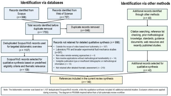
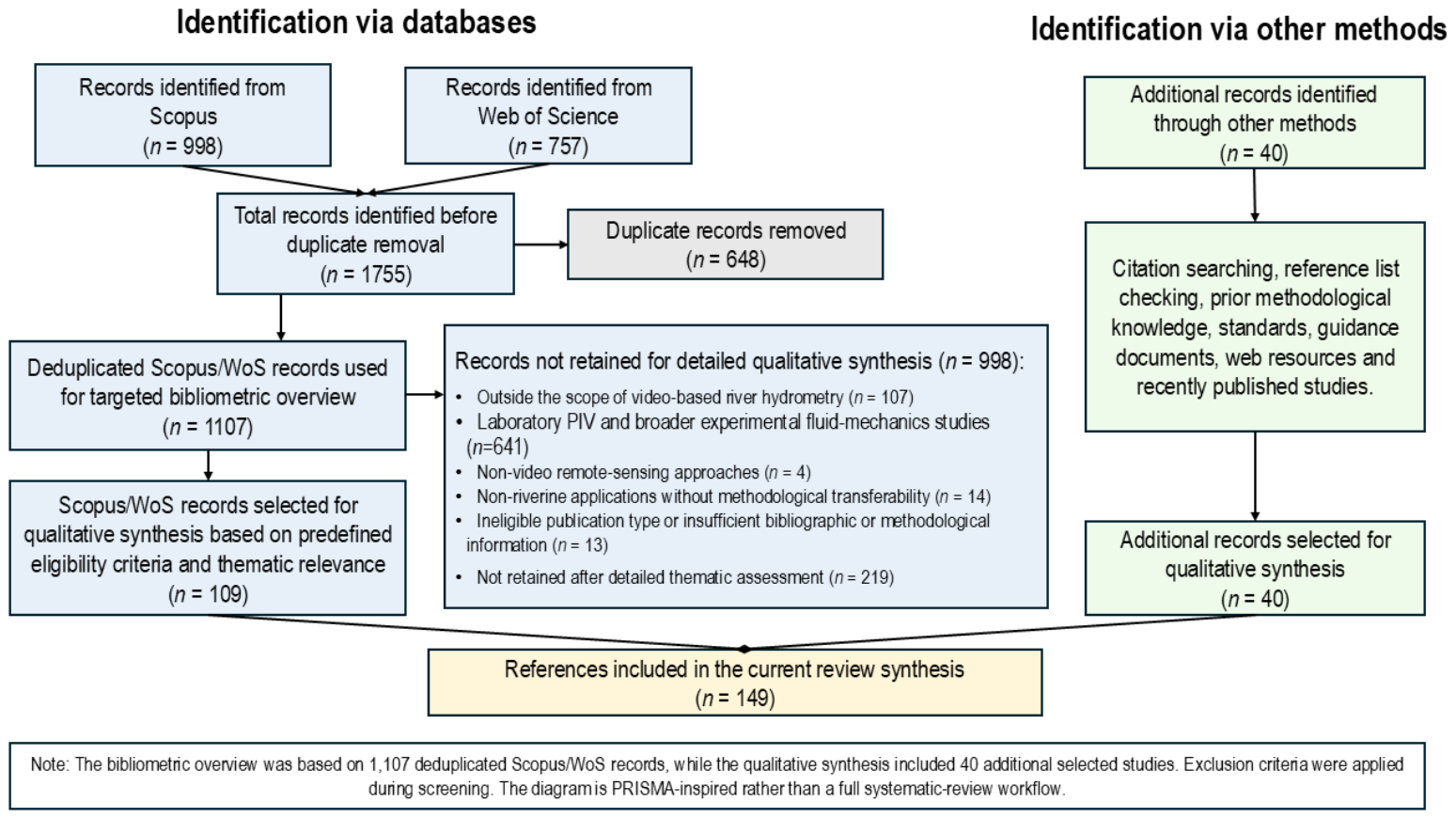
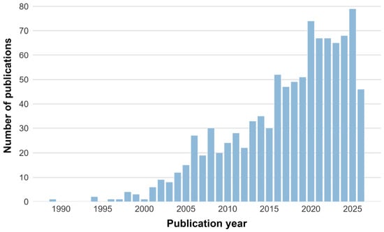
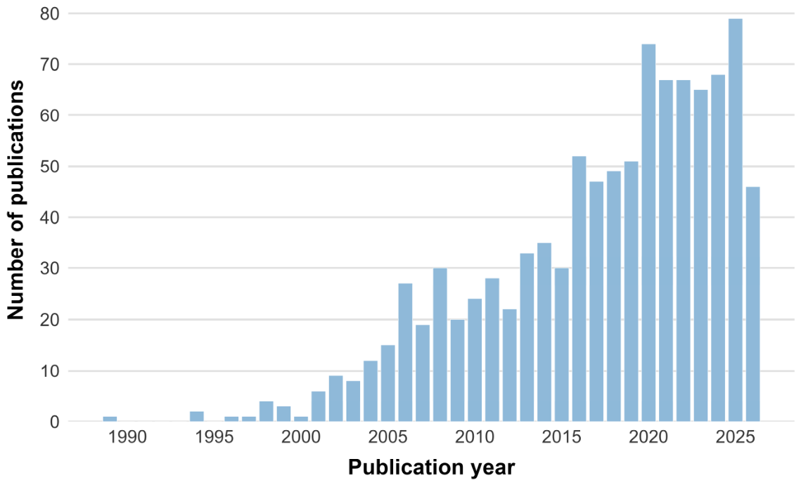
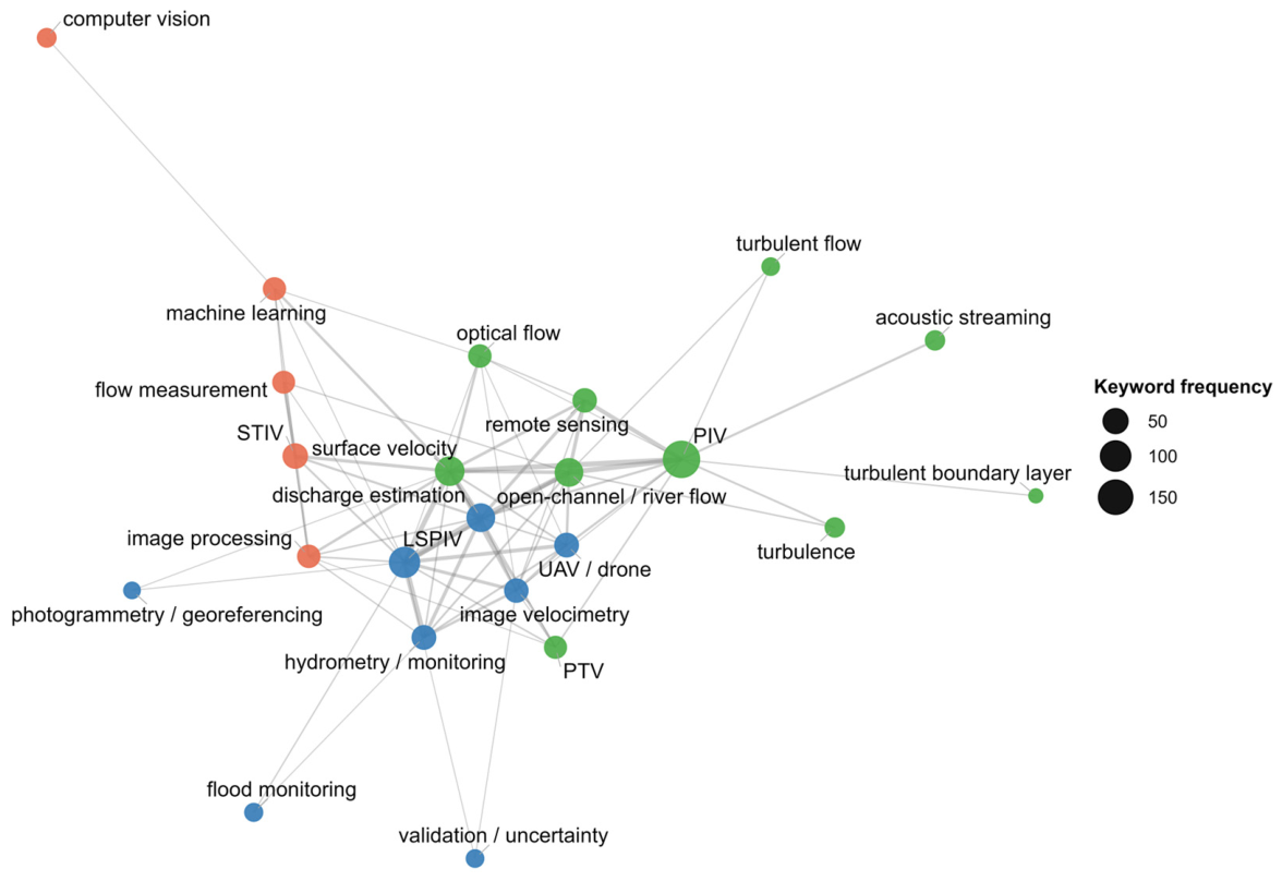

Disclaimer/Publisher’s Note: The statements, opinions and data contained in all publications are solely those of the individual author(s) and contributor(s) and not of MDPI and/or the editor(s). MDPI and/or the editor(s) disclaim responsibility for any injury to people or property resulting from any ideas, methods, instructions or products referred to in the content. |
© 2026 by the authors. Licensee MDPI, Basel, Switzerland. This article is an open access article distributed under the terms and conditions of the Creative Commons Attribution (CC BY) license.