


Abstract
The unique climate and rivers of the Southern Great Plains of the United States have shaped both ecological and human communities. Historically, the rivers of this region supported a wide variety of endemic species evolutionarily adapted to the particularly harsh environment, characterized by flow variability, periodic flooding and drying, and overall complexity. In this review, we provide an extensive overview of the many perils that the rivers of the Southern Great Plains are now facing due to the anthropogenic changes centered on river dam construction, high agricultural water demand, and groundwater depletion. These factors have fundamentally reshaped the flow regime of the Southern Great Plains rivers, resulting in a decline of native fish assemblages and increases in invasive species as a consequence of modified sediment transport, decrease in microhabitat diversity, changes in channel morphology, and an increase in habitat fragmentation. The case that we describe in the present article represents a prototypical example of the ecological consequences of human-induced alterations of river ecosystems. Here, we present this case as an example of damming-induced alteration of the riverine ecosystem, and we propose possible conservation measures to restore the original riverine environment and protect the currently threatened native fish diversity.
1. Introduction
Rivers are important dynamic ecosystems that support a diverse collection of aquatic life. When riverine ecosystems are healthy and natural, native species thrive. On the other hand, changes in their equilibrium can endanger the survival of the native species. The responses of native species to ecosystem change have been widely documented in the scientific literature [1,2,3,4,5,6,7]. This research has shown that species highly adapted to their ecosystems do not benefit from large, rapid environmental changes. Instead, the effects of change can be devastating for the species’ populations [8,9]. The Southern Great Plains (SGP) rivers are ecosystems that have undergone rapid changes due to anthropogenic factors [10,11,12,13]. Organisms inhabiting SGP rivers are exposed to challenging habitat conditions [14]. Indeed, the region experiences pronounced environmental variability and hydrological volatility, with recurring cycles of severe drought and intense flooding, accompanied by extreme temperatures that drive large fluctuations in water temperature throughout the day [14]. Due to their harsh environmental conditions, SGP rivers host many unique endemic species [15]. Drastic changes to the rivers’ environment place these highly adapted species at risk, changing the assemblage of organisms within SGP rivers [1,16].
During the 1960s and 1970s, a quarter of the United States dams were built during a boom in global dam construction [12]. This boom eventually led to 63% of the world’s rivers longer than 621 miles (999.4 km) being dammed [17]. The SGP rivers were not immune to this trend, with all major rivers in this region being impounded [14]. Reservoirs in the SGP region were built to prevent flooding, provide water for agriculture and human consumption, and generate hydroelectric power. While dams provide essential socio-economic benefits such as water security and flood mitigation, they are the leading cause of significant hydrologic disruption to rivers [18].
In the United States, dams have had the greatest impact in the Great Plains and Southwest [18]. Numerous studies have shown that dams in the SGP region have caused extensive habitat fragmentation [19,20], encroachment of riparian vegetation [10,21], changes to the natural flow regime, altered fish assemblages, and modified channel morphology [1,10,15,19,20,22,23,24,25,26]. These changes have transformed SGP rivers, shifting them from historically braided, wide, and shallow channels to straighter, narrower, and deeper river systems. Native species are evolutionarily adapted to the complexity that once characterized SGP rivers. With the changes they have undergone, SGP rivers have turned into more generalist environments, forcing out specialist endemic species like the Arkansas River shiner (Notropis girardi), the plains minnow (Hybognathus placitus) and the peppered chub (Macrhybopsis tetranema), replacing them with species like the red shiner (Cyprinella lutrensis) and the sand shiner (Notropis stramineus) [1]. The natural flow regime and habitat of SGP rivers are vital to the success and persistence of the species that rely on the complex environment of the historical SGP. The ecological health of these rivers is in danger, but through studying them, we may be able to alter the fate of their endemic species.
Although the individual effects of river regulation and exploitation on SGP river hydrology, geomorphology, and fish assemblages have been well studied, these processes have largely been considered separately. A synthesis that demonstrates historical context while connecting anthropogenic drivers to changes in the flow regime, sediment transport, river morphological change, habitat connectivity, and the consequent changes to the fish assemblage and decline of endemic fishes is lacking. By considering these processes together, this review highlights how interacting anthropogenic alterations have progressively changed the conditions of SGP rivers and how it has affected their inhabitants. Furthermore, this article addresses the need to connect SGP river ecological change to conservation strategies aimed at restoring the dynamic river processes that native species have evolved to depend on.
2. Physiographic and Climatic Setting
The SGP is a vast expanse of grassland that covers large portions of Oklahoma, Texas, Kansas, and eastern New Mexico. The SGP region is characterized by gently rolling semi-arid prairie. This area of the United States contains all three types of prairies that are seen within the larger Great Plains region: tallgrass, mixed grass, and shortgrass prairies. This region lies in the rain shadow of the Rocky Mountains to the west, causing the area to be semi-arid.
The elevation of the SGP decreases as it moves from west to east. This affects the directionality and flow of rivers in the region. The headwaters of many Great Plains rivers begin in the Rocky Mountains and flow from northwest to southeast, where they join the Mississippi River [14]. This elevation change influences the amount of precipitation the SGP region receives. The western portion of the plains lies in the rain shadow of the Rocky Mountains. As air encounters the mountains, it rises and cools on the windward side, leading to precipitation. On the leeward side of the Rocky Mountains, where the Texas and Oklahoma panhandles are located, the air descends the mountain and warms, having already lost much of its moisture. This leads to changes in the landscape below the mountains and can alter its vegetation and hydrological patterns, creating a water-limited ecosystem [27]. The Western portion of the SGP region only receives 15–20 inches (381–508 mm) of precipitation annually. In comparison, the Eastern portion of the plains can receive up to 56 inches (1422 mm) of annual precipitation, creating a west to east increasing precipitation gradient [28].
The Southern Plains rivers represent highly dynamic aquatic systems characterized by severe thermal and hydrological extremes [11]. Weather patterns strongly influence the rivers of this region as they naturally exist in a state between two extremes: flooding and drying. Weather patterns fluctuate drastically throughout the year. Temperatures soar in the summer, with highs often reaching into the upper 90° s F to low 100°s F (36–39 °C). In this semi-arid environment, mornings can be cooler due to low humidity, with temperatures often averaging between 60° and 70° F (16–21 °C) in the more western part of the plains. This fluctuation causes the river’s water temperature to markedly increase throughout the day, sometimes starting as cool as 70° F (21 °C) in the morning and ending as warm as 90° F (32 °C) in the afternoon. This rapid daytime heating and nighttime cooling puts strong stress on the organisms that inhabit the river, which have become hardy species adapted to the harsh conditions of the Great Plains rivers [11].
With harsh temperature fluctuations throughout the day come frequent storms that make up one of the Great Plains’ defining characteristics: frequent flooding that causes the rivers to expand and shrink throughout the rainy season. The SGP experiences some of the most intense thunderstorms recorded outside the tropics, with many forming quickly and with little to no warning. These storms can produce 50–90% of the plain’s annual precipitation [29]. Despite these high-intensity events, the SGP region is also prone to recurring drought. This duality is a defining feature of the climate regime of the SGP. The most famous period of drought in American history, the Dust Bowl from 1930 to 1936, occurred primarily within this region.
The Dust Bowl has led to many studies on drought. In one such study, Karl [30] found that the Great Plains region experiences longer periods of drought than the rest of the United States. Once dry conditions take hold in this region, they are more likely to persist, contributing to extended periods of water stress for ecosystems, agriculture, and communities. Prolonged drought conditions have major impacts on the region’s rivers. These can include long periods of river habitat fragmentation, during which fish and other river inhabitants are isolated in small patches. This separates rivers into upstream and downstream reaches and can strand fish in isolated pools where survival becomes more difficult, sometimes leading to fish kills [31].
River drying can exacerbate the effects of rapid temperature fluctuations [32]. During droughts, the average ambient temperature increases [33], and rivers carry less water. Water levels drop, the rivers’ flow rates slow, and the rivers become shallower. A shallower river heats more quickly than a deep river due to differences in water volume, further exacerbating the already extreme water temperature fluctuations experienced during summer months [31]. Temperature stress has negative effects on river-dwelling organisms, leading to physiological stress, failed recruitment, and potential death [34]. River drying has also been shown to influence water quality (e.g., ref. [35]).
Drought has been shown to increase salinity, which has been attributed to a lower dilution capacity in drought-affected rivers [32,36,37]. A study on how drought affects river salinity in Texas and Oklahoma found that river salinity increases by a median of 21% during droughts [35]. This increases conductivity, as ions such as salt facilitate the flow of electrical charge through water [33]. Elevated ion concentrations also alter the osmotic gradient between fish and their surrounding environment. Because freshwater fish maintain internal ion concentrations that are typically higher than those of the surrounding water, increases in dissolved ions can disrupt normal osmotic regulation [38]. Changes in osmolarity may force fish to expend additional energy to maintain ion balance through physiological processes such as ion transport across the gills and kidneys. If these conditions persist or become extreme, the increased osmoregulatory demand can lead to physiological stress and reduced fitness.
In a similar vein, increased levels of pollution and bacterial contamination have been observed during droughts. The increase in bacterial contamination is attributed to livestock, which are heavily present in this region, entering the water to cool off or drink more frequently, thereby spreading bacteria into the river [31,33]. Another contributor to river degradation in agricultural areas is nutrient runoff from overapplication of fertilizer, which can cause algal blooms that are frequently observed during droughts [31,33].
The SGP rivers are historically prone to periods of drying and flooding, and the organisms that inhabit them are adapted to this variable environment. However, the effects of climate change are expected to increase drought risk in this region [39], which could severely compromise the survival of the endemic riverine biota of the Great Plains river ecosystems.
3. Hydrology of SGP Rivers
Rivers of the SGP, south of Kansas, consist of three major drainage systems: the Arkansas River Basin, the Red River Basin [14], and the eastern portion of the Rio Grande River system. The Arkansas and Red River Basins are tributaries of the Mississippi River [40]. The Arkansas River is the major waterway of the Arkansas River Basin and has many large rivers that act as its tributaries. These include the Canadian (North and South), the Cimarron, the Neosho (Grand), the Deep Fork, the Salt Fork of the Arkansas, and the Verdigris rivers. The Red River is the major waterway of the Red River Basin and forms part of the Texas-Oklahoma border. The major tributaries of this river include the Washita, Kiamichi, Sulphur, Pease, and Wichita rivers. The Pecos River is a tributary of the Rio Grande River [41].
The rivers in these systems are very similar in nature. Climate plays a major role in shaping the rivers of the SGP region, particularly in terms of flooding and drought cycles. SGP rivers display a streamflow pattern characterized by peak flows in late spring and early summer (when storms are most common and snow is melting at their headwaters), followed by low or intermittent flows in the late summer and early fall [14]. This pattern plays a vital role in structuring the SGP rivers as habitats for a variety of species.
The headwaters of the largest SGP streams, most notably the Canadian and Arkansas Rivers, arise in the upper reaches of the Rocky Mountains. In the Rockies, they are high-gradient streams with powerful flows that run over large boulders located throughout much of the channel [14]. The mountain influence on the rivers is short-lived, as the flows are carried down the mountain and out into the Great Plains, where the landscape changes. The rivers, which were running at a steep incline down mountains and between canyon walls, slow once they hit the much flatter portion of their course. Here, the stream bottom changes from a rocky bed into a sandy bottom, greatly influencing river topology. In the plains, rivers that were once raging and powerful near their headwaters turn into slow, meandering streams. The rivers of this region were historically characterized by wide, shallow (<0.5 m; 15), braided channels that gradually change under variable flow conditions [10,26]. Instead of easily compacted rocks or dirt, the SGP rivers have walls made up of coarse sediment, mostly sand. This dominance of coarse sediment allows the channel to shift in response to flow conditions and weather. Riverbank erosion occurs easily, enabling elevated discharge during high-flow events to reshape channels, shifting the rivers’ courses and creating a braided topology [10]. The erodible banks make flooding a key part of reshaping and changing rivers’ courses, as the increased discharge works away at the channel walls. The Great Plains themselves are also made up of sandy soils. Precipitation in the SGP causes runoff of sandy sediment to flow into the rivers, which can facilitate channel migration by transporting sediment into the stream and further destabilizing the banks [42].
Groundwater interactions in the SGP region, particularly those involving the Ogallala Aquifer, significantly affect the hydrology of the SGP. The Ogallala Aquifer is the largest aquifer in North America, spanning eight states: Colorado, Kansas, Nebraska, New Mexico, Oklahoma, South Dakota, Texas, and Wyoming [43,44]. The Ogallala Aquifer supplies water to the rivers of the SGP through groundwater discharge. This occurs when portions of the aquifer exceed their storage capacity and generate surface flows that feed the rivers. The aquifer is filled primarily through precipitation, when rainwater seeps through the ground and into the aquifer. Aquifers can be artificially recharged through a managed aquifer recharge scheme, but it can be difficult to put this into practice [45]. The natural occurrence of groundwater discharge is a slow process that recharges rivers through a sustained subterranean water upwelling.
The Ogallala Aquifer is one of North America’s most important aquifers for agricultural production of both crops and livestock [46]. It supports around 30% of all agricultural production in the United States [44], with an estimated 95% of the water used going to irrigation [47]. The aquifer also provides drinking water to 82% of people living within its boundaries [44], making it one of the most important water sources in the country. Use of the aquifer for substantial groundwater irrigation started around the 1950s, and portions of the Ogallala Aquifer have been in notable decline since then [47]. Human needs are far outpacing the aquifers’ recharge rate, with groundwater extraction occurring much faster than recharge. In 1987, the U.S. Geological Survey (USGS) began monitoring the Ogallala Aquifer. USGS is tasked with providing information on the aquifer’s status every five years, tracking the aquifer’s rate of rise or decline. The most recent report, released in 2024 [47], highlights that the aquifer in the southern portion of the Great Plains has been in drastic decline. However, the aquifer of the northern Great Plains has remained stable, with some portions even reported to be rising [47].
The depletion of this aquifer is not only alarming for the people that rely on it for drinking water and agriculture, but also for the health of the rivers. Stream drying is already a key characteristic of SGP rivers, but the depletion of the Ogallala Aquifer further exacerbates this characteristic and affects their fish assemblage. The aquifer in the southern region has a very low recharge rate, largely due to its semi-arid climate. Most of the precipitation that enters this region never reaches the depths of the aquifer due to high anthropogenic demand. This lowers the regional water table, leading to the hydrological disconnection of the river channels from the underlying aquifer, which separates the rivers from a major water source. This disconnection intensifies stream drying and has a profound effect on the fish assemblage [13].
The importance of flooding for maintaining the natural morphology of SGP streams cannot be understated. Flooding in SGP rivers occurs when the river channel rises to a level that overflows onto the bank. The periodic flooding of the SGP rivers helps shape not only the rivers’ channels, but also the fish assemblage. During high-flow events, the high velocity and large volume of water erode the channel bed, washing sediment into the river and changing the channel’s shape. This mechanism kept the SGP rivers wide and braided, as floods were frequent and powerful. The erosion-prone nature of the banks of the SGP rivers is integral to their natural channel topography. Without this natural periodic reshaping of the river, the channel will become homogenized, with little of the variability that native species have evolutionarily adapted to. Frequent flooding helps ensure that the channel will erode, allowing the river to reshape.
Post-flood SGP riverbanks are ideal for the establishment of pioneer riparian vegetation as the soil is bare and moist [10]. Key examples are the sandbar willow (Salix exigua) and plains cottonwood (Populus deltoides). The encroachment of riparian vegetation is detrimental to SGP rivers as the roots of the vegetation armor the banks against erosion [48]. Armored banks prevent channel migration, straightening out the wide, meandering channel into a narrower, less complex one. Vegetation further alters the ecosystem’s dynamics by preventing sediment from washing into the stream [21]. Under historical environmental conditions, the pioneer riparian vegetation did not survive flooding, channel migration, and ensuing summer drought. High-flow events kept the rivers’ sandy, barren banks free from vegetation through river scouring. High-velocity flows stripped away any vegetation or seedlings that had become established on the riverbank through the sheer force of the water. Erosion from the current also prevented riparian vegetation from gaining a foothold, as the banks were stripped away along with any plants that had begun to grow. The high frequency of disturbance prevented vegetation from reaching a stable, mature state capable of surviving such events. As the frequency of disturbance has greatly decreased, mature plants have established themselves on the banks, making them more difficult to erode and allowing many more plants to establish.
4. Human Impacts—River Impoundments
The rivers of the Great Plains have undergone significant change over the years. A century ago, the rivers of the SGP appeared quite different. Historically, the SGP rivers were wide and shallow (see Figure 1 for examples). Anthropogenic pressures have irreparably altered the dynamics of rivers within this region to satisfy human needs for fresh water. The human population in the SGP has grown markedly over the last 75 years. According to the U.S. Census Bureau, the populations of states containing portions of the SGP (Arkansas, New Mexico, Oklahoma, and Texas) have risen from about 12.7 million people in the 1950s to approximately 40 million in 2024 [49,50]. This represents a 215% increase over 74 years, with the most drastic increase occurring in Texas, which went from about 8 million people to 31 million people, a 287% increase [49,50]. This rapid increase in population occurred in a region affected by semi-arid conditions and drought, yet it relies heavily on agriculture, the impact of which has weighed heavily on the region’s rivers.
Figure 1.
Historical appearance of SGP rivers. Historically (before shifting to the present-day straighter, narrower and deeper river systems), SGP rivers had braided, wide and shallow channels. Top: Men fording the Arkansas River with horses and oil field equipment (c. 1900–1920). Image from the Devon/Dunning Petroleum Industry Collection of the Oklahoma Historical Society. Bottom: Aerial view of the Canadian River, looking west at Canadian River Bridge west of Norman, OK (c. 1922). Photograph shot from a military aircraft operating out of Fort Sill, OK. Image from the Fort Sill Museum Collection of the Oklahoma Historical Society.
The largest anthropogenic factor that has affected the SGP is the building of impoundments on almost all its rivers [18]. The impact dams have on river systems has been extensively studied [12,18,23,24,25]. River impoundments fundamentally alter river flow regimes by dampening peak flows, reducing flow variability, and fragmenting habitat [12]. These effects have many harmful impacts on the native aquatic inhabitants. During the 1960s and 1970s, many dams were built on SGP rivers, including the Sanford Dam in 1962, the Ute Reservoir in 1963, and Lake Eufaula in 1964 on the Canadian River, and the Keystone Dam in 1964 where the Arkansas and Cimarron rivers meet. These dams were constructed to prevent river flooding, to provide access to water for irrigation, and to generate hydroelectric power. The SGP region has come to rely on dams for benefits to the human population. However, these dams have put the SGP rivers’ endemic ecology in jeopardy.
Floods severely impact both communities and agricultural lands, costing the US between 180 and 496 billion dollars annually [51]. Damming a river allows control of its flow rates during periods of both plentiful water and drought. During the rainy season, impoundments trap excess water upstream of the dammed site. This allows flooding to be controlled and water to be stockpiled for later use during dry periods. When dry periods occur, which they frequently do in the SGP region, water collected during the wet season is released to replenish the river for agricultural use or to provide fresh water for cities. However, while damming benefits the human population, it alters the SGP rivers’ natural flow regimes, which were historically in a state of flooding and drying throughout the year, coinciding with the weather patterns of different seasons. The net result is a reduction in the natural variability of the rivers. Dams drastically reduce water flows. Without large seasonal floods to burst the riverbanks and scour the riverbed, the channel becomes narrower and deeper, with plants rapidly colonizing the exposed sandbars and former riverbeds [10]. Their roots stabilize the sediment, making flooding even more difficult. Figure 2 shows an example of how, at present, SGP rivers have become narrower, deeper and with vegetation-fortified banks.
Figure 2.
Present-day SGP river with narrowed channel. Recent picture of the South Canadian River with narrowed channel (2025). Site coordinates: 36.00, −99.29 (west-central Oklahoma). Photo by Ailey Lindemann-Mitchell.
The downstream effects that dams have on rivers have been widely studied [20,22,24,52,53]. Dams control the natural flow of a river by manipulating the discharge rate and variability in ways that are beneficial to humans. This usually manifests as a decrease in downstream discharge and reduced flow-rate variability, as high-flow events are mitigated. In 2005, Magilligan and Nislow surveyed 21 sites to determine how dams affect hydrologic regimes in rivers by examining pre- and post-dam hydrologic changes throughout the USA. Through data collected from USGS discharge gauges before and after dams were constructed, researchers found the most consistent effect that dams have on a river is significantly reduced peak flow rates regardless of where the dam is located [23]; in fact, 20 of the 21 gauges surveyed showed a reduction in peak flows. This significantly affects the river’s flood frequency regardless of weather conditions.
Periods of high flow allow obligate-riverine fish species to complete their life-history stages. Pelagic-broadcast spawners (pelagophil species) are a reproductive guild once common in SGP rivers and make up a large percentage of the endemic fish species in the region [54]. Pelagophil species spawn semi-buoyant eggs that float in the water column when a significant current is present [55]. The ichthyoplankton drift downstream with the current until the eggs hatch (~1–2 days) and the larvae are capable of free swimming, after which they begin migrating upstream [54,55]. This reproductive strategy leaves this reproductive guild heavily reliant on the natural flow regime of the SGP rivers [15,56].
Pelagophil fish of the same species have a characteristic r-selected reproductive strategy due to a short life span. Individuals spawn asynchronously at multiple random times throughout normal to dry conditions during the spawning season [57]. However, high flow rate induces increased spawning and reproductive synchronization among individuals [15,56,57]. Indeed, the highest percentage of ova and larvae that survive to maturity occurs when the river undergoes high-flow conditions; flow magnitude, rate of change, and timing all significantly contribute to elevated reproductive success [56,58]. Flooding conditions result in higher survivorship because long stretches of unfragmented habitat promote egg drift in the water column and prevent the eggs from sinking to the riverbed. If the current is lost and eggs sink, they risk being covered and suffocated by the ever-shifting sands of the riverbed. High flow rates prevent stream drying, resulting in long sections of unfragmented habitat with stable currents to carry ichthyoplankton downstream. The presence of dams dampens peak flows, making the high-flow events that pelagophil species rely on rare occurrences.
Impoundments fragment once connected stretches of rivers, disrupting hydrologic connectivity and altering the movement of organisms and material throughout the system [59,60,61,62]. In the SGP, this fragmentation is particularly detrimental to obligate-riverine fishes, including pelagic-broadcast spawners, which rely on long stretches of unfragmented river to reproduce successfully [60,63,64]. The lentic habitats created upstream of dams are often unsuitable for obligate-riverine species because their life histories are adapted to dynamic, flowing environments. Many SGP fishes, such as the Arkansas River shiner, peppered chub, and plains minnow, are highly mobile and move upstream after hatching to recolonize suitable river reaches [53,63]. Steffensmeier and colleagues found that pelagophils species with greater movement rates tended to have poorer conservation status [63], highlighting these species’ reliance on habitat connectivity. By interrupting this connectivity, dams fragment populations into upstream and downstream sections and have been identified as a major driver of declining species diversity in the region [2,65]. Many SGP cyprinids have experienced severe range contractions and are now federally listed as endangered or threatened species (Table 1). The peppered chub occupies only 6% of its historical range [66], the Arkansas River shiner only 17% (Figure 3) [67,68], and the Rio Grande silvery minnow 7% [69]. The prairie chub (Macrhybopsis australis), a pelagophil that is not currently listed but is under review [70], has been found to significantly decrease in the presence of upstream dams [71]. In each case the construction of dams and the resulting habitat fragmentation have been cited as key factors contributing to these species’ decline [68,69].
Table 1.
Documented range contractions of imperiled pelagic-broadcast spawners native to SGP rivers. Historical range contractions of endemic SGP pelagic-broadcast spawning fishes listed as threatened or endangered under the U.S. Endangered Species Act [68,69,72]. Species are included only when a quantitative estimate of their range contraction was available; other pelagophils that have experienced declines but do not have a range contraction estimate, are therefore not represented.
Figure 3.
Change in the range of a typical native fish species of the SGP rivers. The map shows the historical (brown) and current (red) ranges of the Arkansas River shiner (Notropis girardi), which has been extirpated from 83% of its historical range in the Arkansas River Basin. The dams along its current range, the South Canadian River, have been marked in blue. Adapted from U.S. Fish and Wildlife Service, 2018 [68].
Fragmentation of river systems into upstream and downstream dam segments restricts gene flow among aquatic species’ populations, thereby reducing genetic diversity over time [73,74]. One example is the Rio Grande Silvery minnow (Hybognathus amarus) [2]. Prior to dam construction, the species was abundant and widely distributed throughout the Rio Grande River. Following impoundment, the species was listed as federally endangered and now persists only within a limited reach of the Rio Grande River bounded by two reservoirs and fragmented by three dams [2,75]. Habitat fragmentation has further limited juvenile recruitment because only a small fraction of the eggs produced during spawning remain within suitable river reaches. Many eggs are transported downstream into the Elephant Butte Reservoir, where they have little chance of survival due to the lack of current needed to keep them suspended in the water column [76]. As a result, the effective population size of the Rio Grande silvery minnow is extremely small relative to the number of adults present in the river (Ne = 78), indicating reduced genetic diversity within the population [2]. This vulnerability is exacerbated by the life history of pelagophil species in the region, which typically have short lifespans consisting of about one year and rely on high reproductive rate (r-selected species), making populations particularly susceptible to rapid declines when environmental conditions change.
5. Human Impacts—Introduced Species
Reservoirs facilitate invasions of non-native species by greatly increasing the amount of standing water, creating new habitats that non-native species may be adapted to and reducing the available natural habitat for native species [77]. The most successful invasions of non-native fish species have occurred in modified rivers [78,79]. In contrast, fish invasions often fail in undammed, natural rivers. More broadly, natural environmental conditions and intact native fish assemblages may provide resistance against invaders. Native species are often adapted to the environmental conditions of the rivers they inhabit, which likely allows them to outcompete non-native species under natural conditions. Anthropogenic impacts can change these conditions and modify the environment to one more favorable to an invader, facilitating successful invasions. Evidence outside of the SGP demonstrates this idea. For instance, a study on Deer Creek in California [80] found that the environmental harshness and biotic pressures prevented the establishment of brown trout (Salmo trutta). One of the most successful invaders in North America [81], the brown trout has failed to become established in the undammed Deer Creek, likely due to native creek competitors and predators. The preserved natural state of Deer Creek has allowed the creek to remain populated by endemic species despite threats from invaders.
To maintain the native fish assemblage in streams, environmental complexity must be preserved [80]. Some of the most prominent species introduced to SGP rivers are common carp (Cyprinus carpio), Western mosquitofish (Gambusia affinis), Red River shiner (Notropis bairdi), and Red River pupfish (Cyprinodon rubrofluviatilis) [82]. The non-native Red River shiner has been cited as a threat to the Arkansas River shiner, as the Red River shiner introduction to the Cimarron River coincided with the extirpation of the Arkansas River shiner [83,84]. Both species share similar life histories and ecological preferences, potentially allowing the Red River shiner to outcompete the native Arkansas River shiner [84]. All invasive fish pose a risk to the native species of the SGP region and many non-endemic fish have successfully invaded the region’s rivers. Representative images of endemic and invasive fish species of SGP rivers are shown in Figure 4.
Figure 4.
Native and invasive fish species from the Southern Great Plains rivers. In reading order: the Arkansas River shiner (Notropis girardi), the peppered chub (Macryhybopsis tetranema), the Red River pupfish (Cyprinodon rubrofluviatilis), the plains minnow (Hybognathus placitus), the red shiner (Cyprinella lutrensis), the largemouth bass (Micropterus salmoides), the bluegill (Lepomis macrochirus), and the Western mosquitofish (Gambusia affinis). The first five species are native, while the last three are invasive. The first four species are lotic SGP riverine specialists, while the last three are lentic generalists. The red shiner thrives in both lotic and lentic environments. Photos 1–7 by Daniel Fenner. Photo 8 by Ryan Hagerty (USFWS).
6. Human Impacts—Sediment Transport
As discussed previously, SGP rivers rely on the constant expansion and contraction of their channels to erode sediment from their banks, thereby maintaining wide, shallow, and braided river morphologies rather than deep, narrow ones. Dam construction interrupts downstream sediment transport [85]. The dam traps sediment from upstream, where it accumulates within the reservoir and is prevented from moving downstream, decreasing reservoir storage capacity and causing sediment starvation below the impoundment.
Sediment is the primary building block of SGP rivers, shaping all aspects of river morphology [10]. The naturally variable flow regime erodes river channels, redistributing sediment throughout the river corridor. This deposited sediment forms mesohabitat such as riffles and sandbars that provide habitat for prairie stream fishes occupying different ecological niches. Depriving downstream reaches of sediment therefore results in major consequences for both channel morphology and ecosystem structure, as sediment starvation removes many of the habitats that endemic species depend on.
The sediment transport capacity of SGP rivers now exceeds the amount of sediment available within the modified channels. At the same time, reduced peak flows allow riparian vegetation to establish along formerly unstable banks. This vegetation stabilizes and armors the banks, preventing the erosion that caused the channels to migrate laterally [48]. As a result, the channels narrow because the flooding that historically maintained wide channels now occurs much less frequently. Despite this, similar volumes of water to those that passed through the wider channels must now pass through a much smaller area. This increases flow velocities within the channel.
The higher-velocity flows enhance the power of sediment-starved water, promoting channel incision and progressively deepening once shallow systems [86,87]. As channels deepen and sediment supply declines, increased flow velocities strip away sandbars and limit their formation, reducing habitat complexity and eliminating critical habitat for many species. The deeper channel also raises the discharge threshold required for overbank flooding, meaning greater amounts of precipitation are needed to produce flood events, further disrupting the river’s natural geomorphic and ecological processes.
The natural environment of SGP rivers is highly turbid due to their naturally erosive, sediment-rich flows. However, sediment retention and channel modification reduce turbidity in the system, altering ecological conditions to which native species are evolutionarily adapted. For instance, the peppered chub is a species evolutionarily adapted to highly turbid waters. Peppered chubs possess barbels and taste buds distributed across their bodies and large olfactory lamellae, which enhance their ability to locate prey under low-visibility conditions [88]. Experimental work demonstrates the importance of this adaptation: while generalist species, such as red shiners or emerald shiners (Notropis atherinoides), experience substantial declines in prey capture as turbidity increases from 0 to 4000 Nephelometric Turbidity Units (NTU), with reductions of 73% and 84%, respectively, peppered chubs show only a modest decrease of about 21% [1]. This adaptation allowed the species to remain effective predators in the naturally turbid conditions characteristic of SGP rivers.
The high turbidity of SGP rivers is important for the persistence of endemic species, which can be outcompeted by generalist species at lower turbidity levels [1]. High turbidity also makes it more difficult for predators to see pelagophil species eggs floating in the water column [89]. Many predators that would target pelagophil species eggs within SGP streams are generalist species, such as the largemouth bass (Micropterus salmoides) or the bluegill (Lepomis macrochirus) [90,91]. These generalist species are not adapted to the high turbidity of SGP rivers and instead thrive in clearer lentic habitats [91]. Without the natural flow of sediment through the SGP rivers, channels become incised, and their complexity is greatly reduced. The high turbidity adapted species are replaced by generalist species that can survive in a clearer environment, displacing specialist species and driving them closer to extinction.
7. Discussion: Ecological Significance and Conservation Plans
The SGP rivers are diverse ecosystems home to many endangered and threatened species, some of which are endemic only to the region. The biodiversity in this region was unique, but changes in the fish assemblage due to threats such as the building of dams, the introduction of invasive species, and changes in the river flow regime have caused the rivers to become less biodiverse, with the majority of their native fish assemblage being replaced by more generalist species. The rivers within the SGP region not only support a variety of ichthyofauna but also a diverse array of terrestrial and aquatic species, including mussels, migratory birds, waterfowl, and mammals [92,93,94].
The natural hydrographs of most SGP rivers have undergone fundamental anthropogenic alterations, and conservation measures are needed to return them to a semblance of their former state. One of the most important actions for the rivers to return to their natural state is the restoration of the flow regime altered by dams and reservoirs [95]. One of the most realistic ways to accomplish this is to work with reservoir operations to implement more frequent and natural reservoir releases [96,97]. In this scenario, the dam remains in place, but the natural flow regime can still be restored. Reservoir releases can be manipulated to mimic the river’s natural flow regime. By mimicking the timing, duration, and magnitude of the river’s natural flows, the river can return to a somewhat natural state. The flow mimicry works to support the downstream reaches of the stream that may otherwise not receive key amounts of water. If flows are increased to a natural pattern, the floodplains of the river can theoretically be restored to some extent, consequently helping to prevent channel incision and providing pelagophil species with a sufficient flow for successful recruitment.
Baruch and colleagues analyzed 25 years of abundance data to determine whether the implementation of reservoir releases that mimic the natural flow regime would positively affect the fish assemblage [97]. By mimicking the natural flow regime, the presence of native fish increased, and non-native fish populations were suppressed. As the flow regime regulated by the reservoir shifted further away from its natural state, the non-native population responded positively. By following the flow regime of the natural environment, the quasi-extinction risk to the rivers’ native assemblage was reduced by more than 40%. This study supports the idea that implementing natural flow outputs by dams can conserve native species in the SGP.
An approach to restoring the natural form and flows of SGP rivers, while directly contributing to the conservation of pelagic-broadcast spawning fishes, is reconnecting secondary channels to the main river channel [98,99,100,101]. Modern SGP rivers have shifted from dynamic and braided to narrower and more homogenized, often leaving former secondary channels disconnected from the active river. Historically, these channels were maintained by high-flow events characteristic of the pre-impoundment era. The loss of secondary channels and the flow regimes required to form new ones have left many SGP rivers with few features to slow the downstream transport of pelagophil eggs [64,98,99,100,102]. Reconnecting existing secondary channels, or potentially constructing new channels that mimic natural channels, could provide areas of reduced flow velocity to increase egg transport time, reducing the risk of eggs being transported into downstream reservoirs.
Recent research on the Pecos River in New Mexico tested the effects that implementing this conservation strategy may have. The U.S. Fish and Wildlife Service and Tetra Tech, Inc. used a model to evaluate how reconnecting a cutoff bent meander could influence the transport time of Pecos Bluntnose Shiner (Notropis simus pecosensis) eggs over the distance of the secondary channel. The model examined transport times during block flows, when releases from the Sumner Dam increased discharge to approximately 1100 cfs. They found that, under these conditions, eggs that pass through the main channel without passing through the secondary channel would only take 10–15 min to float the distance of the secondary channel. In contrast, when the eggs travelled through the secondary channel, they floated between 3.3 and 6.3 h before returning to the main channel. Pecos Bluntnose Shiner eggs hatch in 24–48 h after spawning, meaning a 6-h detour through the secondary channel would substantially increase both their traveling distance and their transport time under high-flow conditions, allowing the eggs to remain farther upstream, away from downstream reservoirs [98,99,100,103]. This helps prevent upstream extirpation of pelagophils and downstream reservoir drift.
Another, admittedly less practical, way to conserve SGP rivers is to remove the existing flow barriers, allowing the rivers’ channel to become more complex as flows become less regulated. While this may seem like a drastic action, this has been done before on a much larger scale. The Klamath River is 263 miles (423.3 km) long and runs through southeastern Oregon and northwestern California. The river is the third-largest producer of salmon and steelhead on the U.S. West Coast. Before dam development, the Klamath Basin produced around 650,000 to 1 million adult salmonids per year [104].
In 1918, the first hydroelectric dam, Copco 1, was built on the Klamath River, dividing it into two sections: the upper Klamath and the lower Klamath [105]. This decreased the river’s connectivity, preventing fish from moving from the lower basin to the upper basin, where salmonid breeding grounds were located. Salmon are anadromous fish that make long runs from saltwater to freshwater to spawn in winter and early spring. However, after the construction of Copco 1, salmon runs in the upper Klamath basin ceased. Three more hydroelectric dams followed Copco 1, further fragmenting the Klamath River and preventing fish migration [106].
The Klamath River was home to three listed species: the Lost River sucker (Deltistes luxatus), shortnose sucker (Chasmistes brevirostris), and a genetically distinct population of coho salmon (Oncorhynchus kisutch) [107]. These species were in decline on this river largely due to the construction of the dams. The dams degraded water quality, blocked anadromous fish migration, caused toxic algal blooms, and increased water temperatures [108].
In 2002, a fish kill of over 34,000 fish, most of which were Chinook salmon (Oncorhynchus tshawytscha), occurred on the river largely due to environmental stressors. The Klamath River had very low flow rates and volume at the time of the Chinook salmon run, leading to a lack of migration cues for the salmon, which quickly became overcrowded in the river. Low water volume caused the river’s temperature to rise. With the large number of salmon in a small space and warmer than average conditions, the parasite Ichthyophthirius multifiliis and the pathogen Flavobacterium columnare quickly spread among fish [109]. The Iron Gate Dam caused the low flows that were responsible for the fish kill. If the flows from the dam had been higher (≥1000 cfs), the fish kill may have been avoided [107]. The 2002 fish kill gained national attention and spurred a call to action among the public to remove the dam.
In 2010 the Klamath Basin Restoration Agreement (KBRA) was signed, part of which included the removal of four hydroelectric dams to conserve native fish populations, aid salmon runs and restore the river to a more natural state [110]. Congress did not pass the legislation to uphold the KBRA on time, but a new agreement was put into place in 2016; the Klamath Hydroelectric Settlement Agreement [111]. After decades of negotiations, the first dam removal was completed (the Copco 2 dam in October of 2023), while Copco 1, Iron Gate, and the J.C. Boyle dams followed suit. All four dams were removed by October 2024 [112].
As the dam removals were completed less than two years ago, no studies have been published on the long-term effects of the dam removal, but many organizations already have studies underway. However, researchers predict that the removal will have significant impacts on the health of the river. Bartholow et al. (2004) predicted that the temperature of the river would decrease after the removal, assisting salmon runs [108]. Quiñones et al. (2014) studied the effect that the removal of the Klamath dam would have on the salmonid population and surmised that dam removal would have immense benefits to populations at all life stages [106]. Without the removal of these dams, the upper Klamath Basin would remain inaccessible to salmonids, preventing the fish from reaching their historical spawning grounds. With the removal of the dam, it is expected that salmonid populations will recover quickly. Chinook salmon are expected to recover within five years of complete dam removal [113], which remains a prediction yet to be tested in future studies. With the removal of the dam, water quality is expected to improve (pH and dissolved oxygen), as well as nutrient concentrations throughout the river, potentially preventing disease outbreaks [113]. This could aid other species such as the listed sucker species and other native ichthyofauna [113].
The Klamath dam removals are expected to have massive impacts on the conservation of native species such as Chinook salmon, steelhead (Oncorhynchus mykiss), and coho salmon. Removing the dams has given these anadromous fish the ability to run the river to their historical spawning grounds. Removal will also allow water quality to return closer to historical levels. The temperature regime of the river will match that of the air temperature, which will make it warmer in the summer when it will benefit fish growth, but cooler in the fall and winter when it is most important for spawning [114]. Algal blooms will become less common as standing water in the river decreases and nutrient buildup decreases. Overall, the removal of these dams will benefit the Klamath River and its native fish assemblage for years to come.
As the dam removal on the Klamath River is predicted to benefit populations and water quality in the very near future [106,108,113,114], dam removals within the SGP rivers could benefit conservation efforts as well. Indeed, the removal of the dams on the SGP rivers could support pelagophil species reproduction, improve water quality and river connectivity, and prevent further channelization. Some of the most imperiled pelagophils appear to rely on habitat connectivity on a large scale. A correlation has been found between how mobile a pelagophil species is and its conservation status, with more mobile species appearing to be more imperiled than their less mobile counterparts [63]. It is therefore clear that pelagophil species rely on the natural flow regimes and habitat connectivity that non-impeded rivers provide [71]. Consequently, the removal of SGP river dams can carry significant conservation benefits for imperiled pelagophil species.
8. Conclusions
Understanding the complexity and inherent variability of SGP river systems is vital to developing effective conservation strategies for the future. Anthropogenic alterations have changed these rivers from dynamic, wide, braided systems into narrow, increasingly homogenized channels. As the rivers have changed, many endemic species adapted to their historically variable conditions have declined and are now threatened with extinction. Species such as the Arkansas River shiner (once a dominant species in the region) and the peppered chub, which have both evolved in response to the natural river morphology and flow dynamics, are increasingly unable to persist as those conditions disappear.
Sediment starvation downstream of dams has reduced turbidity and altered a key characteristic that native species like the peppered chub are adapted to. Morphological adaptations, such as the barbels that allow peppered chubs to find food in highly turbid environments, may provide less of an advantage as water clarity increases and generalist species are able to forage more effectively. Reduced turbidity may also increase the vulnerability of pelagophil eggs to predation. Key evolutionary adaptations that allowed pelagic-broadcast spawning fishes to persist in the highly dynamic rivers of the SGP are being rendered increasingly ineffective. The loss of natural flow regimes has changed almost all aspects of the natural environment of these rivers. The rivers’ channels have narrowed and lost complexity, sediment starvation has limited sandbar formation and decreased turbidity, and riparian vegetation has encroached on the channel banks preventing erosion, subsequently narrowing the rivers. species.
9. Future Directions
Hope for these rivers has not been lost, however. Restoring components of the natural flow regime, removing invasive riparian vegetation to allow for bank erosion, and working to increase habitat connectivity offer promising avenues for returning the SGP rivers to a semblance of their natural state. These actions could restore some of the habitats that native species require to persist and recover. The rivers of the SGP must be recognized for the value they provide not only as a water resource to be controlled, but as dynamic ecosystems that support many endemic species.
We acknowledge that it is unrealistic to expect human influence on the rivers of this region to disappear. Human populations rely heavily on their waters for drinking, livestock, irrigation, and hydroelectric power. Nevertheless, there are ways that humans and the SGP rivers can coexist with less impact on the ecosystem. Where dams have the capability to conduct timed water releases, efforts should be made to develop releases that mimic the natural flow regime of the dammed river. Long-term USGS monitoring records from rivers throughout the region can provide critical data to identify historical patterns informing the magnitude, frequency, and duration of these releases.
Alongside mimicking natural flow regimes, the logistical and economic feasibility of transporting sediment from reservoirs downstream should be evaluated. Restoring a certain amount of sediment transport could help relieve sediment starvation and promote the formation of important habitats such as sandbars, thereby re-establishing high turbidity levels. Sediment removal from reservoirs will benefit not only the river, but also the reservoir itself, as it will increase storage capacity. Continued monitoring and research on pelagic-broadcast spawners are also essential. In particular, more research is needed to understand how changes in channel morphology and turbidity levels affect the resilience of these species.
Without actions such as these, continued exploitation and alteration of SGP rivers will further change the systems from their natural state. Such continued alteration risks the loss of numerous endemic species. Conservation efforts for the SGP riverine ecosystem should therefore focus on returning the rivers to conditions mirroring their natural state. Meaningful actions are needed now if the rivers and their endemic species are to persist.
Author Contributions
Conceptualization, A.L.-M., J.F., D.F., C.B., C.I.A., R.d.I. and H.W.; project administration, R.d.I.; visualization, A.L.-M., D.F. and R.d.I.; supervision, D.F. and H.W.; writing—original draft preparation, A.L.-M.; writing—review and editing, A.L.-M., J.F., D.F., C.B., C.I.A., R.d.I. and H.W. All authors have read and agreed to the published version of the manuscript.
Funding
The work was supported by the United States Fish and Wildlife Service (A.L.-M., J.F., D.F.) and the University of Tulsa (A.L.-M.). The findings and conclusions in this article are those of the authors and do not necessarily represent the views of the United States Fish and Wildlife Service.
Institutional Review Board Statement
Not applicable.
Informed Consent Statement
Not applicable.
Data Availability Statement
No new data were created or analyzed in this study. Data sharing is not applicable to this article.
Conflicts of Interest
The authors declare no conflicts of interest.
Abbreviations
The following abbreviations are used in this manuscript:
| SGP | Southern Great Plains |
| USFWS | United States Fish and Wildlife Service |
| USGS | United States Geological Survey |
References
- Bonner, T.H.; Wilde, G.R. Changes in the Canadian River fish assemblage associated with reservoir construction. J. Freshw. Ecol. 2000, 15, 189–198. [Google Scholar] [CrossRef] [Scilit]
- Alò, D.; Turner, T.E. Effects of habitat fragmentation on effective population size in the endangered Rio Grande silvery minnow. Conserv. Biol. 2005, 19, 1138–1148. [Google Scholar] [CrossRef] [Scilit]
- Perkin, J.S.; Gido, K.B.; Costigan, K.H.; Daniels, M.D.; Johnson, E.R. Fragmentation and drying ratchet down Great Plains stream fish diversity. Aquat. Conserv. Mar. Freshw. Ecosyst. 2014, 25, 639–655. [Google Scholar] [CrossRef] [Scilit]
- Perkin, J.S.; Gido, K.B.; Cooper, A.R.; Turner, T.F.; Osborne, M.J.; Johnson, E.R.; Mayes, K.B. Fragmentation and dewatering transform Great Plains stream fish communities. Ecol. Monogr. 2015, 85, 73–92. [Google Scholar] [CrossRef] [Scilit]
- Dias, M.S.; Tedesco, P.A.; Hugueny, B.; Jezequel, C.; Beauchard, O.; Brosse, S.; Oberdorff, T. Anthropogenic stressors and riverine fish extinctions. Ecol. Indic. 2017, 79, 37–46. [Google Scholar] [CrossRef] [Scilit]
- Nguyen, E.; Perkin, J.S.; Smith, R.; Mayes, K.B.; Trungale, J. Characteristics of the natural flow regime paradigm explain occurrence of imperiled Great Plains fishes. Ecosphere 2021, 12, e03669. [Google Scholar] [CrossRef] [Scilit]
- Moraga, D.; Vivancos, A.; Ruiz, V.H.; Rojas, O.; Diaz, G.; Manosalva, A.; Vega, P.; Habit, E. A century of anthropogenic river alterations in a highly diverse river coastal basin: Effects on fish assemblages. Front. Environ. Sci. 2022, 10, 943586. [Google Scholar] [CrossRef] [Scilit]
- Bell, G.; Collins, S. Adaptation, extinction and global change. Evol. Appl. 2008, 1, 3–16. [Google Scholar] [CrossRef] [Scilit]
- Kristensen, T.N.; Ketola, T.; Kronholm, I. Adaptation to environmental stress at different timescales. Ann. N. Y. Acad. Sci. 2018, 1476, 5–22. [Google Scholar] [CrossRef] [Scilit]
- Friedman, J.M.; Osterkamp, W.R.; Scott, M.I.; Auble, G.T. Downstream effects of dams on channel geometry and bottomland vegetation: Regional patterns in the Great Plains. Wetlands 1998, 18, 619–633. [Google Scholar] [CrossRef] [Scilit]
- Dodds, W.K.; Gido, K.; Whiles, M.R.; Fritz, K.M.; Matthews, W.J. Life on the Edge: The Ecology of Great Plains Prairie Streams. BioScience 2004, 54, 205–216. [Google Scholar] [CrossRef] [Scilit]
- Costigan, K.H.; Daniels, M.D. Damming the prairie: Human alteration of Great Plains river regimes. J. Hydrol. 2012, 444–445, 90–99. [Google Scholar] [CrossRef] [Scilit]
- Perkin, J.S.; Gido, K.B.; Falke, J.A.; Fausch, K.D.; Crockett, H.; Johnson, E.R.; Sanderson, J. Groundwater declines are linked to changes in Great Plains stream fish assemblages. Proc. Natl. Acad. Sci. USA 2017, 114, 7373–7378. [Google Scholar] [CrossRef] [Scilit]
- Vaughn, C.C.; Gido, K.B.; Bestgen, K.R.; Perkin, J.S.; Platania, S.P. Southern Plains Rivers. In Rivers of North America; Elsevier: New York, NY, USA, 2005; pp. 407–467. [Google Scholar] [CrossRef] [Scilit]
- Hoagstrom, C.W.; Turner, T.F. Recruitment ecology of pelagic-broadcast spawning minnows: Paradigms from the ocean advance science and conservation of an imperiled freshwater fauna. Fish Fish. 2013, 16, 282–299. [Google Scholar] [CrossRef] [Scilit]
- Perkin, J.S.; Gido, K.B. Fragmentation alters stream fish community structure in dendritic ecological networks. Ecol. Appl. 2012, 22, 2176–2187. [Google Scholar] [CrossRef] [Scilit]
- Grill, G.; Lehner, B.; Thieme, M.; Geenen, B.; Tickner, D.; Antonelli, F.; Babu, S.; Borrelli, P.; Cheng, L.; Crochetiere, H.; et al. Mapping the world’s free-flowing rivers. Nature 2019, 569, 215–221. [Google Scholar] [CrossRef] [Scilit] [PubMed]
- Graf, W.L. Dam nation: A geographic census of American dams and their large-scale hydrologic impacts. Water Resour. Res. 1999, 35, 1305–1311. [Google Scholar] [CrossRef] [Scilit]
- Dudley, R.K.; Platania, S.P. Flow regulation and fragmentation imperil pelagic-spawning riverine fishes. Ecol. Appl. 2007, 17, 2074–2086. [Google Scholar] [CrossRef] [Scilit]
- Perkin, J.S.; Gido, K.B. Stream fragmentation thresholds for a reproductive guild of Great Plains fishes. Fisheries 2011, 36, 371–383. [Google Scholar] [CrossRef] [Scilit]
- Florsheim, J.L.; Mount, J.F.; Chin, A. Bank erosion as a desirable attribute of rivers. Bioscience 2008, 58, 519–529. [Google Scholar] [CrossRef] [Scilit]
- Poff, N.L.; Allan, J.D.; Bain, M.B.; Karr, J.R.; Prestegaard, K.L.; Richter, B.D.; Sparks, R.E.; Stromberg, J.C. The natural flow regime. Bioscience 1997, 47, 769–784. [Google Scholar] [CrossRef] [Scilit]
- Magilligan, F.L.; Nislow, K.H. Changes in hydrologic regime by dams. Geomorphology 2005, 71, 61–78. [Google Scholar] [CrossRef] [Scilit]
- Graf, W.L. Downstream hydrologic and geomorphic effects of large dams on American rivers. Geomorphology 2006, 79, 336–360. [Google Scholar] [CrossRef] [Scilit]
- Poff, N.L.; Olden, J.D.; Merritt, D.M.; Pepin, D.M. Homogenization of regional river dynamics by dams and global biodiversity implications. Proc. Natl. Acad. Sci. USA 2007, 104, 5732–5737. [Google Scholar] [CrossRef] [Scilit]
- Julian, J.P.; Thomas, R.E.; Moursi, S.; Hoagland, B.W.; Tarhule, A. Historical variability and feedbacks among land cover, stream power, and channel geometry along the lower Canadian River floodplain in Oklahoma. Earth. Surf. Process. Landf. 2011, 37, 449–458. [Google Scholar] [CrossRef] [Scilit]
- Zhao, Y.; Zhang, Z.; Tan, H.; Hu, Y. Rain shadow effect of individual shrub related to crown shape in arid desert. Ecohydrology 2019, 12, e2076. [Google Scholar] [CrossRef] [Scilit]
- Flanagan, P.X.; Mahmood, R. Spatiotemporal analysis of extreme precipitation in the southern Great Plains hydroclimate region. J. Appl. Meteor Climatol. 2023, 62, 393–409. [Google Scholar] [CrossRef] [Scilit]
- Maupin, C.R.; Roark, E.B.; Thirumalai, K.; Shen, C.; Schumacher, C.; Kampen-Lewis, S.V.; Housson, A.L.; McChesney, C.L.; Baykara, O.; Yu, T.; et al. Abrupt Southern Great Plains thunderstorm shifts linked to glacial climate variability. Nat. Geosci. 2021, 14, 396–401. [Google Scholar] [CrossRef] [Scilit]
- Karl, T.R. Some spatial characteristics of drought duration in the United States. J. Appl. Meteorol. Climatol. 1983, 22, 1356–1366. [Google Scholar] [CrossRef] [Scilit]
- Caruso, B.S. Regional river flow, water quality, aquatic ecological impacts and recovery from drought. Hydrol. Sci. J. 2001, 46, 677–699. [Google Scholar] [CrossRef] [Scilit]
- Van Vliet, M.T.H.; Zwolsman, J.J.G. Impact of summer droughts on the water quality of the Meuse River. J. Hydrol. 2008, 353, 1–17. [Google Scholar] [CrossRef] [Scilit]
- Caruso, B.S. Temporal and spatial patterns of extreme low flows and effects on stream ecosystems in Otago, New Zealand. J. Hydrol. 2002, 257, 115–133. [Google Scholar] [CrossRef] [Scilit]
- Archdeacon, T.P.; Diver-Franssen, T.A.; Bertrand, N.G.; Grant, J.D. Drought results in recruitment failure of Rio Grande silvery minnow (Hybognathus amarus), an imperiled, pelagic-broadcast spawning minnow. Environ. Biol. Fish. 2020, 103, 1033–1044. [Google Scholar] [CrossRef] [Scilit]
- Jones, E.; van Vliet, M.T.H. Drought impacts on river salinity in the US: Implications for water scarcity. Sci. Total Environ. 2018, 644, 844–853. [Google Scholar] [CrossRef] [Scilit]
- Mayer, B.; Shanley, J.B.; Bailey, S.W.; Mitchell, M.J. Identifying sources of stream water sulfate after a summer drought in the Sleepers River watershed (Vermont, USA) using hydrological, chemical, and isotopic techniques. Appl. Geochem. 2010, 25, 747–754. [Google Scholar] [CrossRef] [Scilit]
- Mosley, L.M. Drought impacts on the water quality of freshwater systems; review and integration. Earth-Sci. Rev. 2015, 140, 203–214. [Google Scholar] [CrossRef] [Scilit]
- Boeuf, G.; Payan, P. How should salinity influence fish growth? Comp. Biochem. Physiol. C Toxicol. Pharmacol. 2001, 4, 411–423. [Google Scholar] [CrossRef] [Scilit]
- Cook, B.I.; Ault, T.R.; Smerdon, J.E. Unprecedented 21st century drought risk in the American Southwest and Central Plains. Sci. Adv. 2015, 1, e1400082. [Google Scholar] [CrossRef] [Scilit]
- Yang, J.; Zhou, C.; Will, R.; Wagner, K.; Ouyang, Y.; King, C.; Winrich, A.; Tian, H. River flow decline across the entire Arkansas River Basin in the 21st Century. J. Hydrol. 2023, 618, 129253. [Google Scholar] [CrossRef] [Scilit]
- Osborne, M.J.; Diver, T.A.; Turner, T.F. Introduced Populations as genetic reservoirs for imperiled species: A case study of the Arkansas River shiner (Notorpis girardi). Conserv. Genet. 2013, 14, 637–647. [Google Scholar] [CrossRef] [Scilit]
- Hoagstrom, C.W.; Brooks, J.E.; Davenport, S.R. A large-scale conservation perspective considering endemic fishes of the North American plains. Biol. Conserv. 2011, 144, 21–34. [Google Scholar] [CrossRef] [Scilit]
- McGuire, V.L. Changes in Water Levels and Storage in the High Plains Aquifer, Predevelopment to 2005; USGS FS 2007-3029; Water Reports and Publications; United States Geological Survey: Reston, VA, USA, 2007. [CrossRef] [Scilit]
- Rhodes, E.C.; Perotto-Baldivieso, H.L.; Tanner, E.P.; Angerer, J.P.; Fox, W.E. The declining Ogallala Aquifer and the future role of rangelands science on the North American High Plains. Rangel. Ecol. Manag. 2023, 87, 83–96. [Google Scholar] [CrossRef] [Scilit]
- Zhang, H.; Xu, Y.; Kanyerere, T. A review of the managed aquifer recharge: Historical development, current situation and perspectives. Phys. Chem. Earth 2020, 118–119, 102887. [Google Scholar] [CrossRef] [Scilit]
- Deines, J.M.; Schipanski, M.E.; Golden, B.; Zipper, S.C.; Nozari, S.; Rottler, C.; Guerrero, B.; Sharda, V. Transitions from irrigated to dryland agriculture in the Ogallala Aquifer: Land use suitability and regional economic impacts. Agric. Water Manag. 2020, 233, 106061. [Google Scholar] [CrossRef] [Scilit]
- McGuire, V.L.; Strauch, K.R. Water-Level and Recoverable Water in Storage Changes, High Plains Aquifer, Predevelopment to 2019 and 2017 to 2019; United States Geological Survey, Scientific Investigations Report 2023-5143; Water Reports and Publications; United States Geological Survey: Reston, VA, USA, 2024. [CrossRef] [Scilit]
- Hubble, T.C.T.; Docker, B.B.; Rutherfurd, I.D. The role of riparian trees in maintaining riverbank stability: A review of Australian experience and practice. Ecol. Eng. 2010, 36, 292–304. [Google Scholar] [CrossRef] [Scilit]
- U.S. Census Bureau. 1950 Census of Population: Volume 1. Number of Inhabitants; U.S. Census Bureau: Suitland, MD, USA, 1952. Available online: https://www.census.gov/library/publications/1952/dec/population-vol-01.html (accessed on 16 March 2026).
- U.S. Census Bureau. Annual and Cumulative Estimates if Resident Population Change for the United States, Regions, States, District of Columbia and Puerto Rico: April 1, 2020 to July 1, 2025; NST-EST2025-POP; U.S. Census Bureau: Suitland, MD, USA, 2025. Available online: https://www2.census.gov/programs-surveys/popest/tables/2020-2025/state/totals/NST-EST2025-POP.xlsx (accessed on 16 March 2026).
- JEC (US Congress Joint Economic Committee). Flooding Costs the U.S. Between $179.8 and $496.0 Billion Each Year. 2024. Available online: www.jec.senate.gov/public/_cache/files/bc171a7e-2829-462d-8193-7b7c4d59a6e3/jec-report-on-economic-cost-of-flooding.pdf (accessed on 16 March 2026).
- Baxter, R.M. Environmental effects of dams and impoundments. Annu. Rev. Ecol. Syst. 1977, 8, 255–283. [Google Scholar] [CrossRef] [Scilit]
- Ligon, F.K.; Dietrich, W.E.; Trush, W.J. Downstream ecological effects of dams. Bioscience 1995, 45, 183–192. [Google Scholar] [CrossRef] [Scilit]
- Archdeacon, T.P.; Davenport, S.R.; Grant, J.D.; Henry, E.B. Mass upstream dispersal of pelagic-broadcast spawning cyprinids in the Rio Grande and Pecos River, New Mexico. West. N. Am. Nat. 2018, 78, 100–105. [Google Scholar] [CrossRef] [Scilit]
- Dudley, R.K.; Platania, S.P. Imitating the physical properties of drifting semibuoyant fish (cyprinidae) eggs with artificial eggs. J. Freshw. Ecol. 1999, 14, 423–430. [Google Scholar] [CrossRef] [Scilit]
- Durham, B.W.; Wilde, G.R. Effects of streamflow and intermittency on the reproductive success of two broadcast-spawning cyprinid fishes. Ichthyol. Herpetol. 2009, 2009, 21–28. [Google Scholar] [CrossRef] [Scilit]
- Durham, B.W.; Wilde, G.R. Asynchronous and synchronous spawning by smalleye shiner Notropis buccula from the Brazos River, Texas. Ecol. Freshw. Fish 2008, 7, 528–541. [Google Scholar] [CrossRef] [Scilit]
- Perkin, J.S.; Acre, M.R.; Ellard, J.K.; Rodger, A.W.; Trungale, J.F.; Winemiller, K.O.; Yancy, L.E. Flow-recruitment relationships for shoal chub and implications for managing environmental flows. N. Am. J. Fish. Manag. 2022, 43, 1260–1275. [Google Scholar] [CrossRef] [Scilit]
- Pringle, C. What is hydrologic connectivity and why is it ecologically important? Hydrol. Process. 2003, 17, 2685–2689. [Google Scholar] [CrossRef] [Scilit]
- Taylor, C.M.; Mayes, K.B. Impact of hydrologic alteration on Brazos River pelagophilic minnows. Trans. Am. Fish. Soc. 2022, 151, 474–486. [Google Scholar] [CrossRef] [Scilit]
- Grill, G.; Lehner, B.; Lumsdon, A.E.; MacDonald, G.K.; Zarfl, C.; Liermann, C.R. An index-based framework for assessing patterns and trends in river fragmentation and flow regulation by global dams at multiple scales. Environ. Res. Lett. 2015, 10, 015001. [Google Scholar] [CrossRef] [Scilit]
- Chen, Q.; Li, Q.; Lin, Y.; Zhang, J.; Xia, J.; Ni, J.; Cooke, S.J.; Best, J.; He, S.; Feng, T.; et al. River damming impacts on fish habitat and associated conservation measures. Rev. Geophys. 2023, 61, 1–64. [Google Scholar] [CrossRef] [Scilit]
- Steffensmeier, Z.; Mayes, K.B.; Perkin, J.S. Linking short-term movement rate of pelagic-broadcast spawning fishes to river fragment length and conservation status. Biol. Conserv. 2024, 293, 110585. [Google Scholar] [CrossRef] [Scilit]
- Perkin, J.S.; Brewer, S.K.; Echelle, A.A.; Kocovsky, P.M. Avoiding a macabre future for Macrhybopsis—A special section on improving management and conservation of chubs. N. Am. J. Fish. Manag. 2023, 43, 1145–1150. [Google Scholar] [CrossRef] [Scilit]
- Spinti, R.A.; Condon, L.A.; Zhang, J. The evolution of dam induced river fragmentation in the United States. Nat. Commun. 2023, 14, 3820. [Google Scholar] [CrossRef] [Scilit]
- U.S. Fish and Wildlife Service [USFWS]. Endangered and threatened wildlife and plants; endangered species status for peppered chub and designation of critical habitat. Fed. Regist. 2022, 87, 11188. [Google Scholar]
- U.S. Fish and Wildlife Service [USFWS]. Endangered and threatened wildlife and plants; Final rule to list the Arkansas River Basin population of the Arkansas River shiner (Notropis girardi) as threatened. Fed. Regist. 1998, 63, 64772. [Google Scholar]
- U.S. Fish and Wildlife Service. Species Status Assessment Report for the Arkansas River Shiner (Notropis girardi) and Peppered Chub (Macrybybopsis tetranema); Version 1.0, with appendices; U.S. Fish and Wildlife Service: Albuquerque, NM, USA, 2018; 172p.
- U.S. Fish and Wildlife Service. Rio Grande Silvery Minnow (Hybognathus amarus) Recovery Plan, First Revision; U.S. Fish and Wildlife Service: Albuquerque, NM, USA, 2010; 210p.
- U.S. Fish and Wildlife Service [USFWS]. Endangered and threatened wildlife and plants; 90-day finding on a petition to list the prairie chub as threatened or endangered. Fed. Regist. 2011, 76, 20911. [Google Scholar]
- Mollenhauer, R.; Brewer, S.K.; Perkin, J.S.; Swedberg, D.; Wedgeworth, M.; Steffensmeier, Z.D. Connectivity and flow regime direct conservation priorities for pelagophil fishes. Aquat. Conserv. Mar. Freshw. Ecosyst. 2021, 31, 3215–3227. [Google Scholar] [CrossRef] [Scilit]
- U.S. Fish and Wildlife Service [USFWS]. Recovery Plan for Sharpnose (Notropis oxyrhynchus) and Smalleye (N. buccula) Shiners; U.S. Fish and Wildlife Service [USFWS]: Arlington, TX, USA, 2022; 29p.
- Vera-Escalona, I.; Senthivasan, S.; Habit, E.; Ruzzante, D.E. Past, present, and future of a freshwater fish metapopulation in a threatened landscape. Conserv. Biol. 2018, 32, 849–859. [Google Scholar] [CrossRef] [Scilit]
- Zarri, L.J.; Palkovacs, E.P.; Post, D.M.; Therkildsen, N.O.; Flecker, A.S. The evolutionary consequences of dams and other barriers for riverine fishes. Bioscience 2022, 72, 431–448. [Google Scholar] [CrossRef] [Scilit]
- Bestgen, K.R.; Platania, S.P. Status and conservation of the Rio Grande silvery minnow, Hybognathus amarus. Southwest. Nat. 1991, 36, 225–232. [Google Scholar] [CrossRef] [Scilit]
- Dudley, R.K. Ichthyofaunal Drift in Fragmented Rivers: Empirically Based Models and Conservation Implications. Ph.D. Thesis, University of New Mexico, Albuquerque, NM, USA, December 2004. [Google Scholar] [CrossRef]
- Havel, J.E.; Eunmi Lee, C.; Vander Zanden, J.M. Do reservoirs facilitate invasions into landscapes? Bioscience 2005, 55, 518–525. [Google Scholar] [CrossRef] [Scilit]
- Moyle, P.B. Fish Introductions into North America: Patterns and Ecological Impact. In Ecology of Biological Invasions of North America and Hawaii; Springer: New York, NY, USA, 1986. [Google Scholar] [CrossRef] [Scilit]
- Bunn, S.E.; Arthington, A.H. Basic principles and ecological consequences of altered flow regimes for aquatic deflation basin lakes. J. Environ. Manag. 2002, 30, 492–507. [Google Scholar] [CrossRef] [Scilit]
- Baltz, D.M.; Moyle, P.B. Invasion resistance to introduced species by a native assemblage of California stream fishes. Ecol. Appl. 1993, 3, 246–255. [Google Scholar] [CrossRef] [Scilit]
- Budy, P.; Gaeta, J.W. Brown trout as a global invader. In Brown Trout: Biology, Ecology, and Management; Lobón-Caerviá, J., Sanz, N., Eds.; John Wiley & Sons Ltd.: Hoboken, NJ, USA, 2018; pp. 523–540. [Google Scholar] [CrossRef] [Scilit]
- Gido, K.B.; Schaefer, J.F.; Pigg, J. Patterns of fish invasions in the Great Plains of North America. Biol. Conserv. 2004, 118, 121–131. [Google Scholar] [CrossRef] [Scilit]
- Felley, J.D.; Cothran, E.G. Notropis bairdi (Cyprinidae) in the Cimarron River, Oklahoma. Southwest. Nat. 1981, 25, 564. [Google Scholar] [CrossRef] [Scilit]
- Luttrell, G.R.; Underwood, D.M.; Fisher, W.L.; Pigg, J. Distribution of the Red River shiner, Notropis bairdi, in the Arkansas River drainage. Proc. Okla. Acad. Sci. 1995, 75, 61–62. [Google Scholar]
- Kondolf, G.M.; Gao, Y.; Annadale, G.W.; Morris, G.L.; Jiang, E.; Zhang, J.; Cao, Y.; Carling, P.; Fu, K.; Guo, Q.; et al. Sustainable sediment management in reservoirs and regulated rivers: Experiences from five continents. Earth’s Future 2014, 2, 255–280. [Google Scholar] [CrossRef] [Scilit]
- Kondolf, G.M. Profile: Hungry water: Effects of dams and gravel mining of river channels. Environ. Manag. 1997, 21, 533–551. [Google Scholar] [CrossRef] [Scilit]
- Kondolf, G.M.; Annandale, G.; Rubin, Z. Sediment starvation from dams in the lower Mekong River Basin: Magnitude of the effect and potential mitigation opportunities. In Proceedings of the 36th IAHR World Congress, The Hague, The Netherlands, 28 June–3 July 2015. [Google Scholar]
- Bonner, T.H.; Wilde, G.R. Effects of turbidity on prey consumption by prairie stream fishes. Trans. Am. Fish. Soc. 2002, 131, 1203–1208. [Google Scholar] [CrossRef] [Scilit]
- Utne-Palm, A.C. Visual feeding of fish in a turbid environment: Physical and behavioural aspects. Mar. Freshw. Behav. Physiol. 2002, 35, 111–128. [Google Scholar] [CrossRef] [Scilit]
- Howick, G.L.; O’Brien, W.J. Piscivorous feeding behavior of largemouth bass: An experimental analysis. Trans. Am. Fish. Soc. 1983, 112, 508–516. [Google Scholar] [CrossRef] [Scilit]
- Huenemann, T.W.; Dibble, E.D.; Fleming, J.P. Influence of turbidity on the foraging of largemouth bass. Trans. Am. Fish. Soc. 2012, 141, 107–111. [Google Scholar] [CrossRef] [Scilit]
- Vaughn, C.C.; Taylor, C.M. Impoundments and the decline of freshwater mussels: A case study of an extinction gradient. Conserv. Biol. 1999, 13, 912–920. [Google Scholar] [CrossRef] [Scilit]
- Augustine, D.; Davidson, A.; Dickinson, K.; Pelt, B.V. Thinking like a grassland: Challenges and opportunities for biodiversity conservation in the Great Plains of North America. Rangel. Ecol. Manag. 2021, 78, 281–295. [Google Scholar] [CrossRef] [Scilit]
- Londe, D.W.; Davis, C.A.; Robertson, E.P.; Hovick, T.J.; Loss, S.R. Migratory shorebirds have dynamic and shifting habitat associations under variable precipitation conditions in the Southern Great Plains. Ornithol. Appl. 2025, 127, duaf024. [Google Scholar] [CrossRef] [Scilit]
- Poff, N.L.; Zimmerman, J.K. Ecological responses to altered flow regimes: A literature review to inform the science and management of environmental flows. Freshw. Biol. 2010, 55, 194–205. [Google Scholar] [CrossRef] [Scilit]
- Adams, J.B.; Taljaard, S.; Van Niekerk, L. Water releases from dams improve ecological health and societal benefits in downstream estuaries. Estuaries Coasts 2023, 46, 2244–2258. [Google Scholar] [CrossRef] [Scilit]
- Baruch, E.M.; Yarnell, S.M.; Granatham, T.E.; Ayers, J.R.; Rypel, A.L.; Lusardi, R.A. Mimicking functional elements of the natural flow regime promotes native fish recovery in a regulated river. Ecol. Appl. 2024, 34, e3013. [Google Scholar] [CrossRef] [Scilit]
- Tetra Tech, Inc.; U.S. Fish and Wildlife Service. Pecos River Geomorphology: A Sustainable Habitat Approach for the Pecos Bluntnose Shiner (Notropis simus pecocensis); U.S. Fish and Wildlife Service: Albuquerque, NM, USA, 2019; 210p.
- Tetra Tech, Inc.; U.S. Fish and Wildlife Service. Pecos River Geomorphology: Phase II, A Sustainable Habitat Approach for the Pecos Bluntnose Shiner (Notropis simus pecocensis); U.S. Fish and Wildlife Service: Albuquerque, NM, USA, 2020; 74p.
- Tetra Tech, Inc.; U.S. Fish and Wildlife Service. Pecos River Geomorphology: Phase III, A Sustainable Habitat Approach for the Pecos Bluntnose Shiner (Notropis simus pecocensis); U.S. Fish and Wildlife Service: Albuquerque, NM, USA, 2021; 45p.
- Wilke, K.; Rust, A.; Weissenfluh, D.; Iddings, B.; Wulf, S. Shaping the future of conservation: A model for restoring oxbows in Iowa and beyond. Front. Environ. Sci. 2024, 12, 1370512. [Google Scholar] [CrossRef] [Scilit]
- Worthington, T.A.; Brewer, S.K.; Farless, N.; Grabowski, T.B.; Gregory, M.S. Interacting effects of discharge and channel morphology on transport of semibuoyant fish eggs in large, altered river systems. PLoS ONE 2014, 9, e96599. [Google Scholar] [CrossRef] [Scilit]
- U.S. Fish and Wildlife Service [USFWS]. Pecos Bluntnose Shiner (Notropis simus pecocensis) 5-Year Review: Summary and Evaluation; U.S. Fish and Wildlife Service: Albuquerque, NM, USA, 2006; 39p.
- Gresh, T.; Lichatowich, J.; Schoonmaker, P. An estimation of historic and current levels of salmon production in the Northeast Pacific ecosystem. Fisheries 2000, 25, 15–21. [Google Scholar] [CrossRef] [Scilit]
- Keel, D.J.; Karpenko, K.; Blankenship, S.M.; Schumer, G.; O’Rourke, O.; Ostberg, C.O.; Chase, D.A.; Duda, J.J. A molecular specimen bank for contemporary and future study captures landscape-scale biodiversity baselines before Klamath River dam removal. Sci. Rep. 2025, 15, 20679. [Google Scholar] [CrossRef] [Scilit]
- Quiñones, R.M.; Grantham, T.E.; Harvey, B.N.; Kiernan, J.D.; Klasson, M.; Wintzer, A.P.; Moyle, P.B. Dam removal and anadromous salmonid (Oncorhynchus spp.) conservation in California. Rev. Fish Biol. Fish. 2014, 25, 195–215. [Google Scholar] [CrossRef] [Scilit]
- National Academies of Sciences. Endangered and Threatened Fishes in the Klamath River Basin; The National Academies Press: Washington, DC, USA, 2004. [Google Scholar] [CrossRef] [Scilit]
- Bartholow, J.M.; Campbell, S.G.; Flug, M. Predicting the thermal effects of dam removal on the Klamath River. Environ. Manag. 2004, 34, 856–874. [Google Scholar] [CrossRef]
- Belchik, M.; Hillemeier, D.; Pierce, R.M. The Klamath River Fish Kill of 2002; Analysis of Contributing Factors; PCFFA-155; Yurok Tribal Fisheries Program: Klamath, CA, USA, 2004. [Google Scholar]
- Klamath River Renewal Corporation. Klamath River Basin Restoration Agreement for the Sustainability of Public and Trust Resources and Affected Communities; Klamath River Renewal Corporation: Berkeley, CA, USA, 2010. [Google Scholar]
- Klamath River Renewal Corporation. Klamath Hydroelectric Settlement Agreement; Klamath River Renewal Corporation: Berkeley, CA, USA, 2016. [Google Scholar]
- Klamath River Renewal Corporation. Lower Klamath Project: Exhibit A-1 Definite Decommissioning Plan Amended Surrender Application; Klamath River Renewal Corporation: Berkeley, CA, USA, 2020. [Google Scholar]
- Hamilton, J.; Rondorf, D.W.; Hampton, M.; Quiñones, R.; Simondet, J.; Smith, T. Synthesis of the Effects to Fish Species of Two Management Scenarios for the Secretarial Determination on Removal of the Lower Four Dams on the Klamath River; Biological Subgroup for the Secretarial Determination Regarding Potential Removal of the Lower Four Dams of the Klamath River: Arcata, CA, USA; Western Fisheries Research Center: Washington, DC, USA, 2011; 175p.
- Stanford, J.; Duffy, W.; Cluer, B.; Detrich, P.; Eberle, L.; Edmondson, S.; Foott, S.; Hampton, M.; Kann, J.; Malone, K.; et al. Conceptual Model for Restoration of the Klamath River; USGS: Medford, OR, USA, 2011.
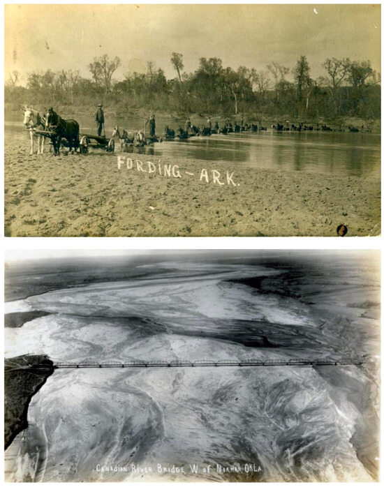
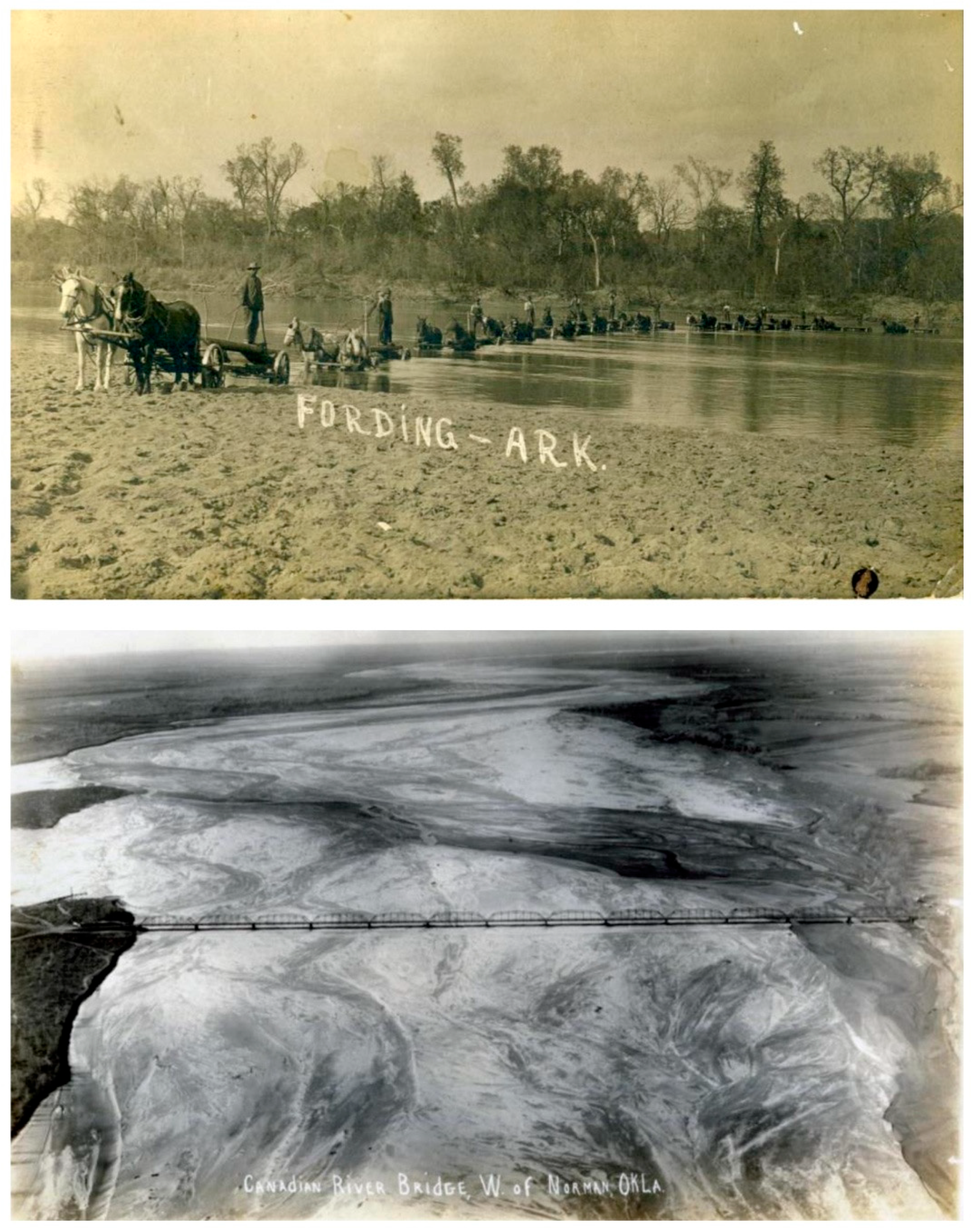
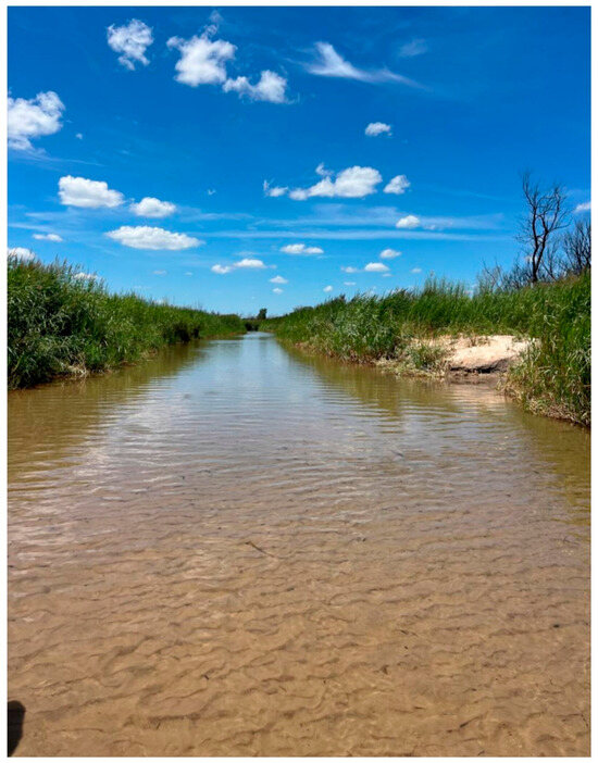
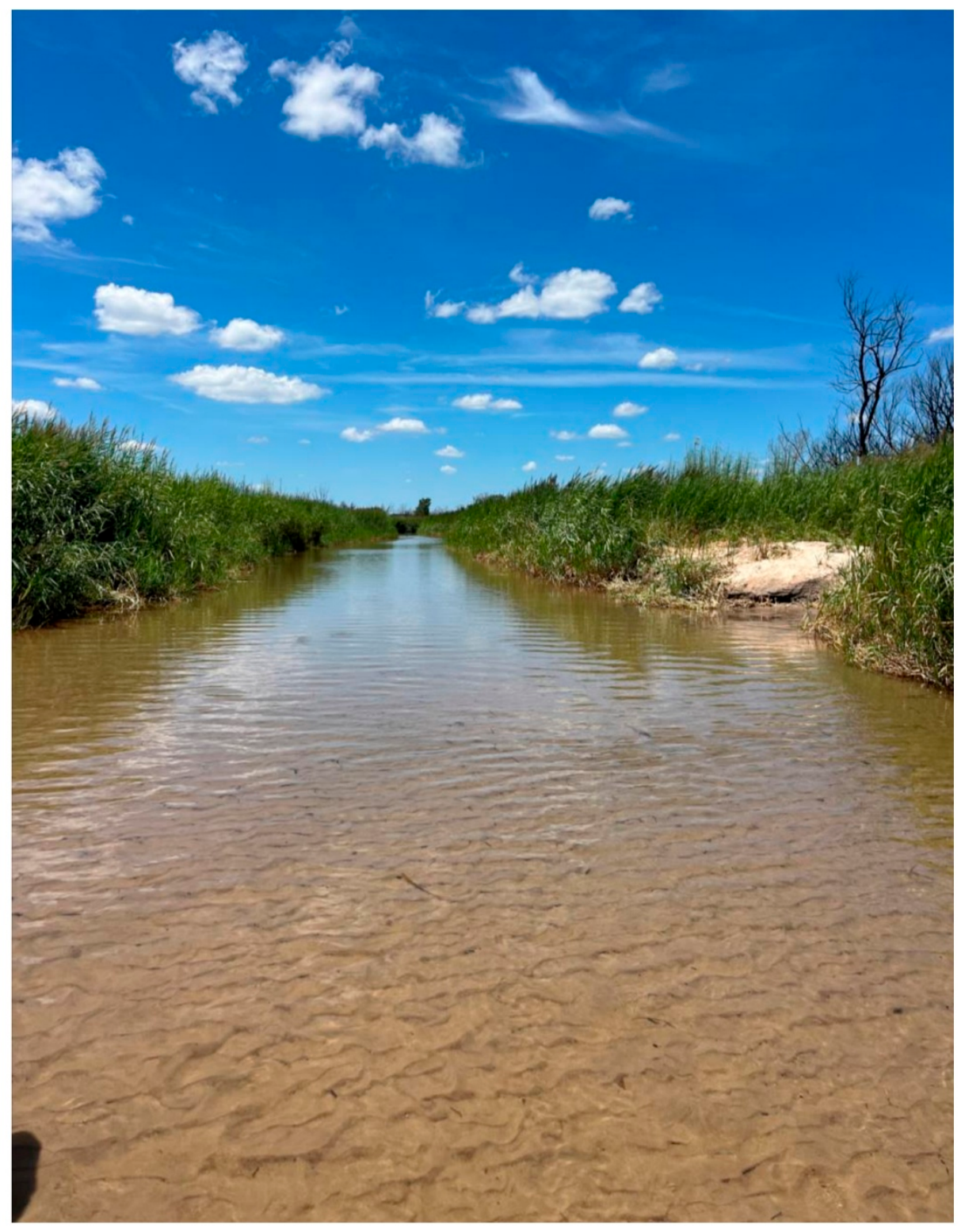
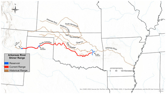
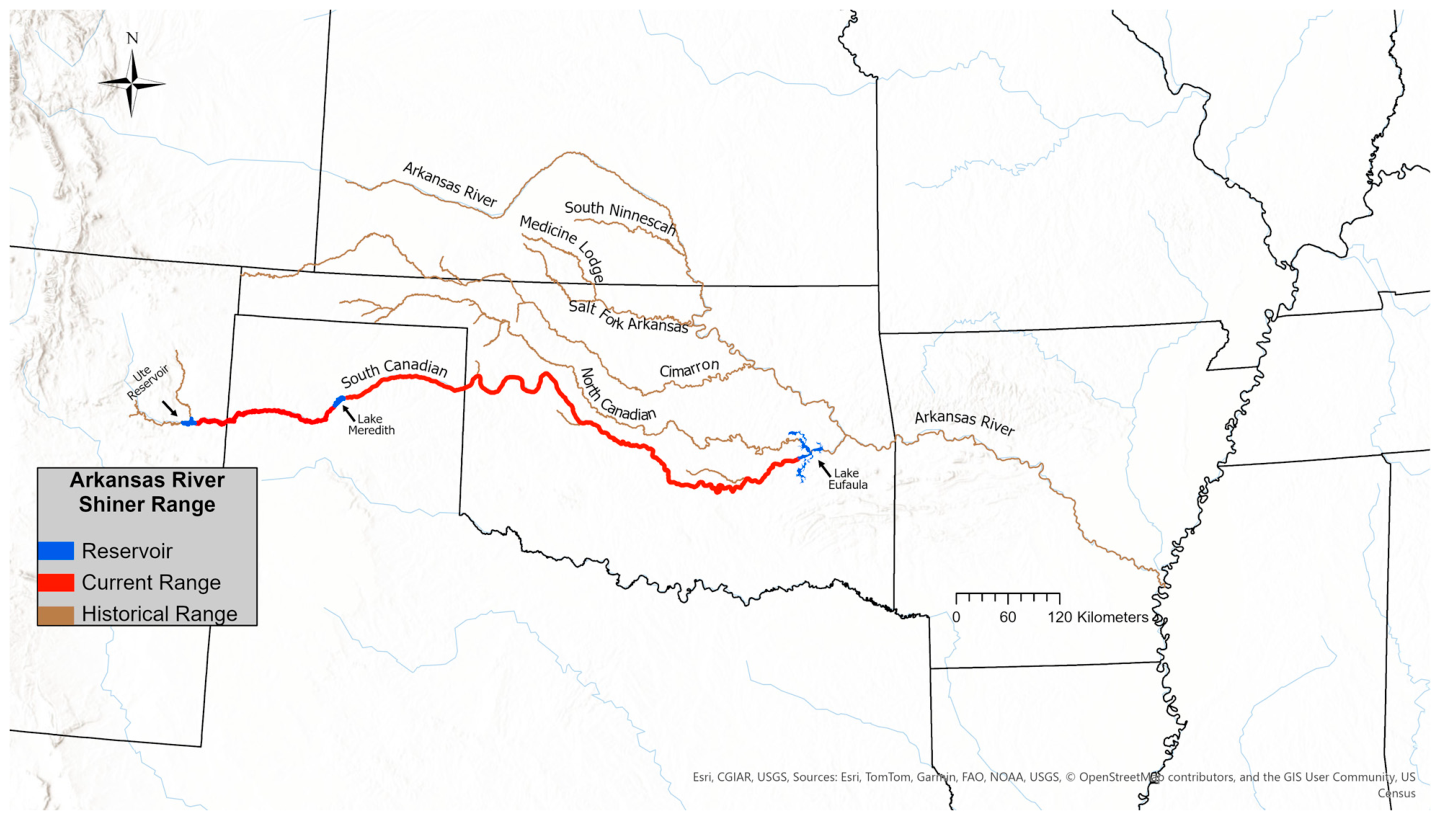
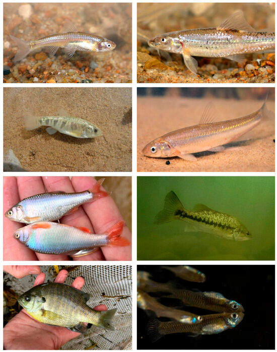
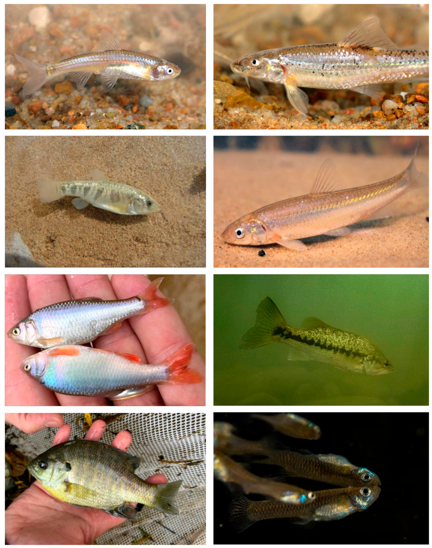

Disclaimer/Publisher’s Note: The statements, opinions and data contained in all publications are solely those of the individual author(s) and contributor(s) and not of MDPI and/or the editor(s). MDPI and/or the editor(s) disclaim responsibility for any injury to people or property resulting from any ideas, methods, instructions or products referred to in the content. |
© 2026 by the authors. Licensee MDPI, Basel, Switzerland. This article is an open access article distributed under the terms and conditions of the Creative Commons Attribution (CC BY) license.