


Conservation 2026, 6(2), 63; https://doi.org/10.3390/conservation6020063 - 21 May 2026
Abstract
The Southern Stuttering Frog, Mixophyes australis, is a newly described threatened species endemic to Australia that is suffering severe and ongoing declines. The species is currently presumed extinct from the southern two thirds of its range, primarily driven by the amphibian chytrid
[...] Read more.
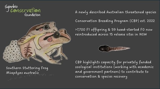
The Southern Stuttering Frog, Mixophyes australis, is a newly described threatened species endemic to Australia that is suffering severe and ongoing declines. The species is currently presumed extinct from the southern two thirds of its range, primarily driven by the amphibian chytrid fungus (Batrachochytrium dendrobatidis; Bd). In response to the species’ decline, a conservation breeding program (CBP) was established at Symbio Wildlife Park to secure an insurance population and support future reintroductions. Herein, the establishment and management of the CBP for M. australis is described. We detail the captive husbandry framework and tracing progress from the collection of 200 wild-caught tadpoles in April 2022, through to the successful reproduction of the founder colony. Following the revision of husbandry and water management practices, and disease treatment in quarantine to overcome initial mortality, 89 Bd-free individuals were transferred to the breeding facility to establish the insurance colony. Critically, the program has achieved consistent and successful reproduction commencing in April 2024, within 2 years of tadpole collection. The breeding cohort exhibited a distinctive bimodal annual reproductive pattern in captivity, with clear peaks in breeding activity in Austral autumn (March–May) and mid-winter to early spring (July–September). We detail effective husbandry protocols for all life stages of the species, which has resulted in the generation of clutches exhibiting high fertility and high tadpole survivorship. Overall, the program to date has contributed to the reintroduction of over 7700 first-generation (F1) tadpoles and 59 head-started founder (F0) adults across 15 release sites within the species’ historical range in NSW. Herein, we provide important natural history data for the species and considerations for their breeding in captivity, which can inform future conservation efforts for this and other threatened frog species globally.
Full article
(This article belongs to the Special Issue Zoo Conservation as a Bridge to Biodiversity Recovery: Approaches, Perspectives, and Case Studies)
►
Show Figures
Graphical abstract


