


Abstract
This study investigates the relationship between cultural compliance and late dry-season vegetation dynamics in Southwest Sumba, Indonesia, by analysing a decade of August Normalised Difference Vegetation Index (NDVI) data (2016–2025) and Cultural Compliance Scores (CCS) across three sites. Underpinned by lende ura, a local customary philosophy conceptualising the forest as a ‘rain bridge’ that sustains water availability, this cultural framework fosters community commitment to forest conservation. Empirically, this contrast is evident where Delo, actively practising this philosophy, maintained a high mean NDVI (0.90) with a markedly low Coefficient of Variation (CV: 1.96%), whereas Mangga Nippi and Lua Koba exhibited lower mean NDVI (0.58 and 0.66) and higher variability (CV: 26.54% and 11.06%), indicating biocultural divergence. Consequently, this erosion of traditional practices is associated with changes in vegetation and observed declines in hydrological functions, making water increasingly difficult to access and heightening economic vulnerability within an environmental poverty trap. These findings indicate that late dry-season vegetation stability in this dryland setting is closely associated with the strength of customary governance, suggesting that traditional institutions may complement the formal conservation of natural habitats. By pairing a CCS with a decade of NDVI variability, this study provides a replicable framework and testable hypotheses for examining biocultural dynamics in comparable seasonally dry tropical landscapes.
1. Introduction
Forests are deeply integrated into the livelihoods of many Indonesian communities, with an estimated 48.8 million people living in or near forest areas depending on these ecosystems [1,2]. This relationship is often defined by the collection of non-timber forest products (NTFPs), such as wild foods and medicinal plants, alongside traditional agroforestry practices that support both domestic needs and supplementary income [3,4]. However, observations across the archipelago suggest that extensive land conversion and shifting exploitation patterns often coincide with notable deforestation, a trend that mirrors global concerns regarding biodiversity and climate stability [5,6]. In these inhabited landscapes, the way local societies interact with their surroundings is associated with the hydrological and ecological dynamics of the broader system [7].
Ecologically, the stability of tropical vegetation is often viewed through a “constellation of forces” where biophysical elements and human activities are closely linked. In semi-arid regions, factors such as soil nutrient levels and the availability of groundwater during the dry season often reflect the primary boundaries of forest growth. Research suggests that these environments may exist in “alternative stable states”, where the interaction between vegetation cover and fire frequency is linked to feedback loops that maintain either a closed forest or an open savanna [8]. Within this framework, minor shifts in environmental disturbances or resource availability often correspond to significant transitions in ecosystem structure.
In Southwest Sumba, the lende ura philosophy serves as an illustrative example of how traditional beliefs and ecological governance may align [9,10]. Communities surrounding the Yawila Protected Forest spiritually conceptualise the forest as a “rain bridge”, a perspective associated with the delineation of sacred core zones and the promotion of kaliwu (traditional agroforestry) in buffer areas [10,11]. This cultural framework is observed alongside maintained vegetation density, where the harvest of products from buffer zones is linked to a reduction in the necessity of encroaching upon the forest core. Such integrated strategies are increasingly noted for their potential to be associated with socio-ecological resilience by balancing local livelihoods with environmental protection [12,13].
However, these dynamics are also part of a wider context involving demographic pressures and rural migration [14]. The Forest Transition Model suggests that as regions develop, the drivers of forest change—such as agricultural expansion—often shift in their relative importance [15]. Evidence from various frontier regions indicates that migration to forest margins is frequently associated with the conversion of wooded land to agriculture, particularly among households with limited economic alternatives or lower educational attainment [16]. In these scenarios, the history of land use and the accessibility of the terrain appear to be variables associated with the patterns of observed degradation.
Contrastingly, areas near the Rokoraka Protected Forest reflect a pattern of biocultural divergence, where a disconnection between traditional stewardship and current practices is observed. This shift often coincides with weakening traditional authority and increased economic demands, reflected in declining NDVI trends and increased household expenditures on water access [17,18]. While physical geography, such as slope steepness, may naturally influence vegetation health, the significant differences in stability suggest that local institutional effectiveness remains a vital factor. This interplay is framed as an ‘environmental poverty trap’ [19]: a reinforcing feedback loop where diminished cultural adherence and ecological decline correspond to intensifying socio-economic constraints. In this study, this trap is identified using a low CCS and a depleted mean NDVI profile as indicators of the breakdown in biocultural synergy [12].
This study addresses these complexities by examining the relationship between cultural integrity and vegetation dynamics. First, focusing on vegetation consistency, we hypothesise that sites characterised by strong adherence to customary governance will correspond to markedly lower inter-annual variability in late dry-season NDVI Coefficient of Variation (CV). Second, focusing on ecological degradation, we hypothesise that sites experiencing biocultural divergence will be associated with substantially lower mean late dry-season NDVI values, reflecting a depleted ecological baseline characteristic of an ‘environmental poverty trap’.
Despite growing interest in biocultural conservation, few studies pair a quantitatively measured indicator of customary compliance with long-term remote-sensing indicators of vegetation temporal consistency, particularly in seasonally dry tropical settings. The originality of this study therefore lies in coupling decadal NDVI temporal consistency (CV) with a purpose-built CCS as paired, quantifiable indicators of biocultural condition. To our knowledge, this represents the first such application in the under-studied seasonally dry tropics of Southwest Sumba. It offers a transferable framework and testable hypotheses for comparable dryland socio-ecological systems.
1.1. Conceptual Frameworks
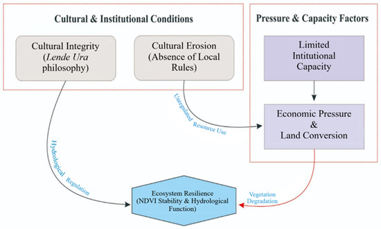
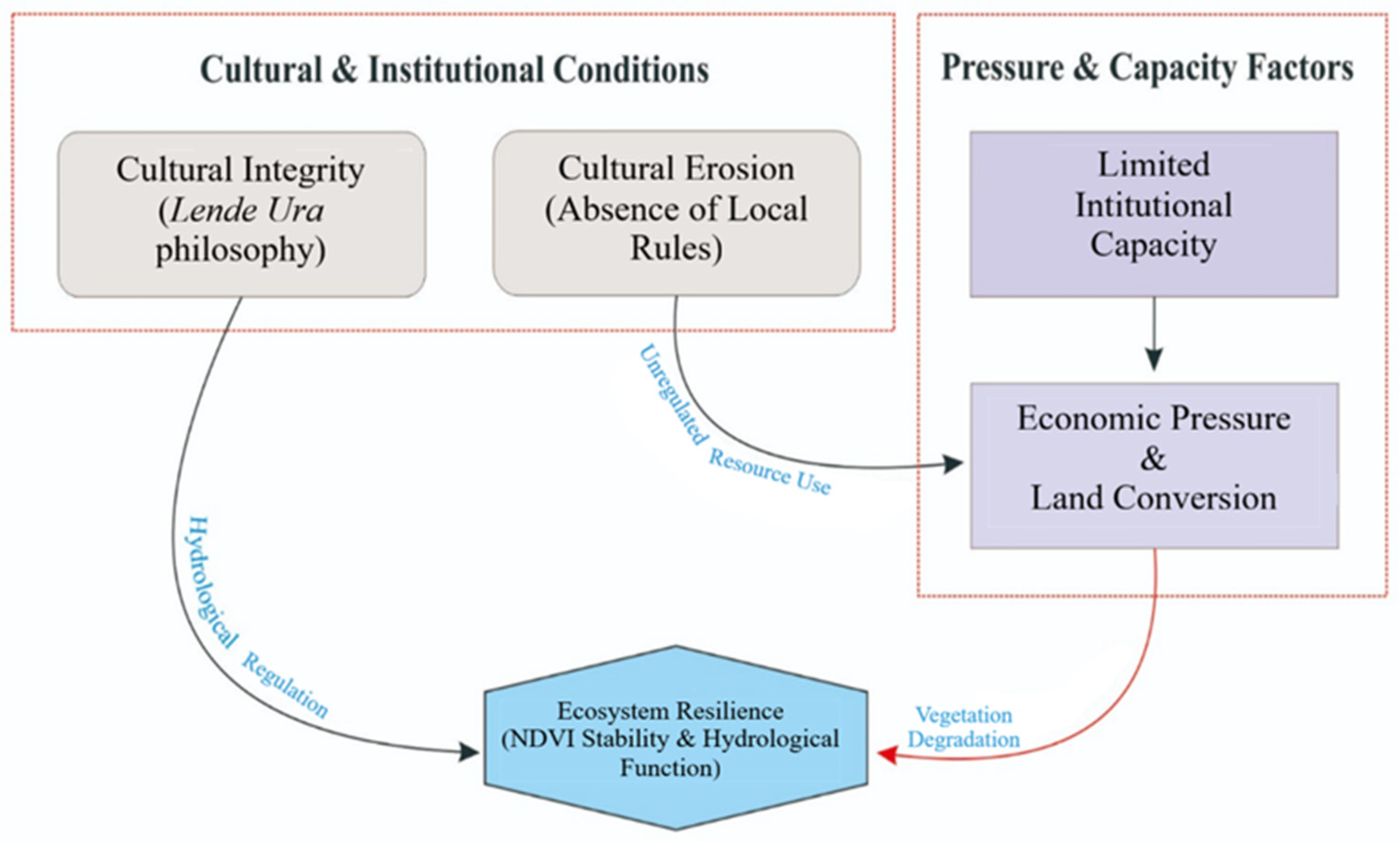
This study is predicated on the idea that a dynamic interplay between biophysical stability and socio-cultural integrity leads to forest conservation in Southwest Sumba [20]. We view forests as complex socio-ecological systems rather than just biological entities, where traditional belief systems serve as unofficial institutions for the administration of natural resources [21]. This framework is intended to map the two different ways that cultural values impact ecological resilience (Figure 1).
Figure 1.
Conceptual framework illustrating the hypothesised pathways linking cultural conditions, socio-economic pressures, and ecosystem resilience. Grey and purple boxes represent cultural–institutional conditions and pressure-capacity factors, respectively. The directional arrows denote hypothesised associative pathways explored through the comparative analysis. They represent a conceptual model of possible relationships rather than validated causal links.
The first pathway, The Cultural Integrity Pathway, demonstrates how hydrological conservation is motivated by the lende ura philosophy. According to this paradigm, ecosystem resilience is hypothesised to be associated with the moral and social incentives for forest protection that accompany cultural adherence [18]. In this study, trends in the NDVI over a ten-year period were used to track steady plant cover and consistent water resources, which are biophysical manifestations of resilience.
On the other hand, biocultural divergence is represented by the path of cultural erosion and economic pressure. The commodification of natural resources has been sparked by the decline of traditional values and the weakening of traditional leadership [9]. Exploitative land-use practices become the norm when scarce human resources are used to meet urgent economic demands. Degraded NDVI profiles and the introduction of charges for water that should be free are examples of how this synergy is associated with patterns of deforestation and increasing environmental vulnerability, ultimately trapping populations in a vicious cycle of environmental poverty trap.
1.2. Objectives
The primary objective of this study is to examine the association between cultural compliance with customary forest governance and late dry-season vegetation dynamics across three sites in Southwest Sumba, Indonesia. Specifically, we aim to (1) compare NDVI variability and temporal consistency across sites with differing levels of cultural compliance; (2) assess the relationship between traditional institutional strength and observed vegetation patterns; and (3) explore how socio-cultural factors may be associated with household water access costs. Beyond these methodological objectives, this study has broader implications for conservation philosophy and policy, discussing how biocultural approaches may complement conventional forest management strategies, and considering the potential relevance of performance-based incentives for communities demonstrating sustained commitment to customary conservation practices.
2. Materials and Methods
2.1. Area of Study and Environmental Context
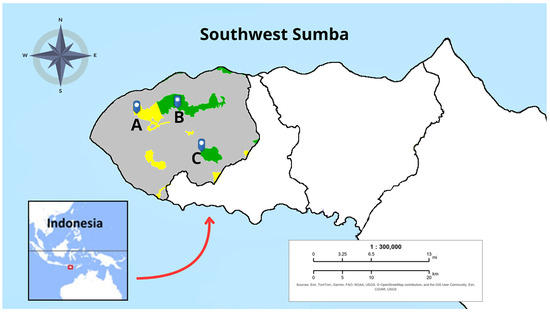
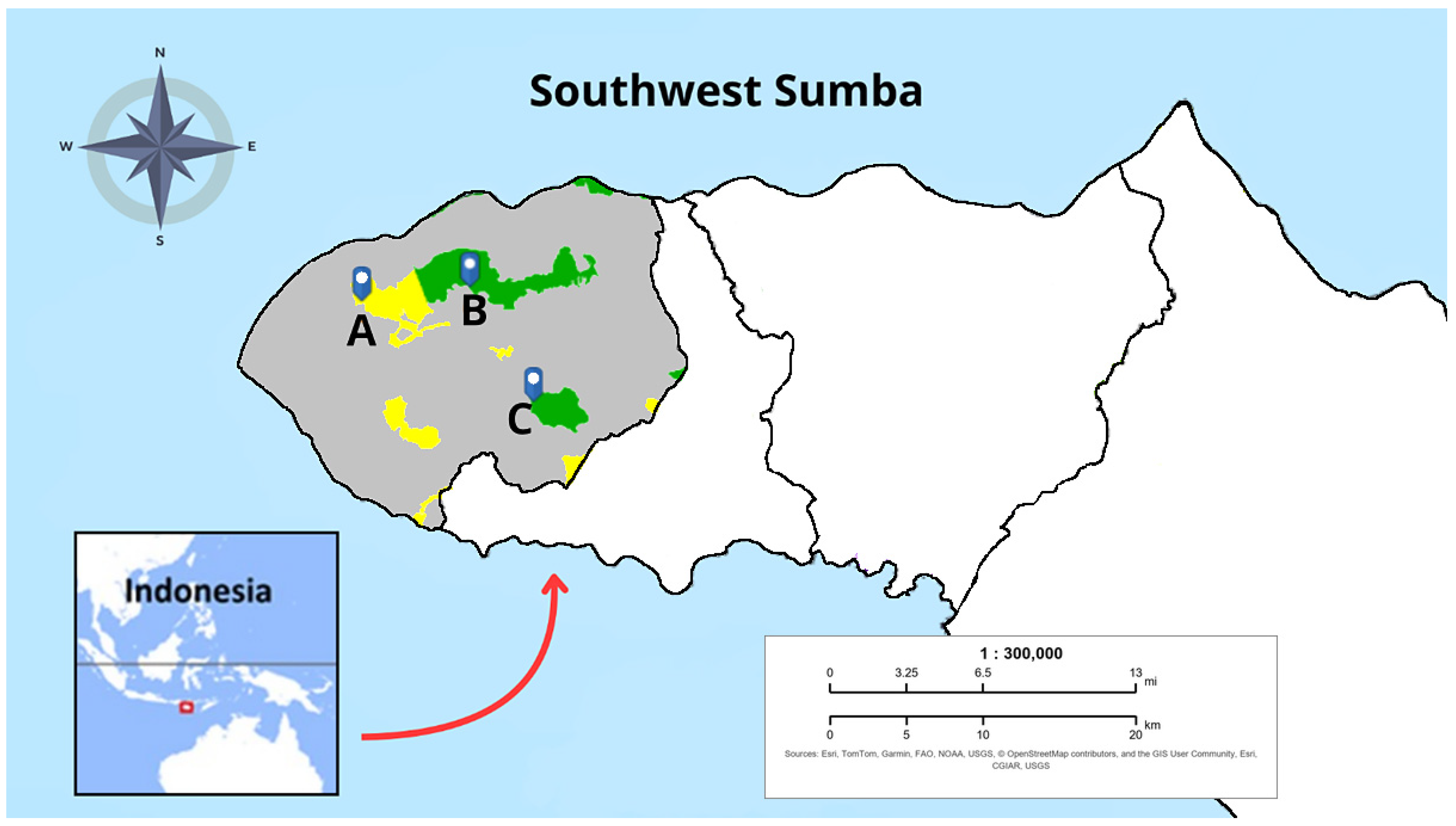
This study was conducted in Southwest Sumba Regency, East Nusa Tenggara Province, Indonesia, by comparing three purposively selected locations, namely Mangga Nippi (North Kodi District), Lua Koba (West Wewewa District), and Delo (South Wewewa District), as shown in Figure 2. The primary criterion for site selection was based on data from the local Forest Management Unit, which categorised these areas into distinct levels of community cultural compliance with customary forest conservation rules (characterised as strong, transitional, and declining). To minimise selection bias, the sites were controlled for macro-environmental homogeneity, with all three locations exhibiting nearly identical mean rainfall (0.47 mm/day, Table 1). This approach allows for a comparative assessment of the association between cultural compliance and observed ecological conditions across the sites.
Figure 2.
Spatial distribution of the three purposively selected case-study sites (A: Mangga Nippi, B: Lua Koba, C: Delo) within the highlighted boundary of Southwest Sumba Regency. Green and yellow polygons denote protected and production forest zones, respectively. The base map and administrative boundaries were derived from the Geospatial Information System Interactive Map (SIGAP) [22]. The inset map contextualises the study sites within the Indonesian archipelago.
Table 1.
Environmental and sociocultural characteristics of the three study villages and their associated state forest areas in Southwest Sumba Regency.
To provide a comprehensive overview of the environmental and socio-cultural context at each site, the physical characteristics and governance principles are summarised in Table 1.
These three sites are separated by a distance of approximately 17–24 km but are located within a similar climatic zone [24]. To establish an environmental baseline, climatological data for the 2016–2025 period were retrieved from the NASA POWER API. This region exhibits distinct monsoon patterns, with peak rainfall in January and an extreme dry season in August [23]. Seasonal variations served as the temporal framework for this study. Climatological data contextualised the timing of field and satellite observations rather than serving as variables for quantitative statistical testing. August was selected for the remote sensing analysis because vegetation conditions during the peak of the dry season provide a conservative basis for comparing sites with different cultural governance practices [25,26].
2.2. Research Design and Site Characteristics
This study employs a comparative mixed-methods approach to examine the phenomenon of Biocultural Divergence [21,27]. Three sites represent contrasting socio-ecological conditions:
- Vulnerable Biocultural Sites (Around the Rokoraka Production Forest and Protected Forest Areas): represented by the villages of Mangga Nippi and Lua Koba, which have areas experiencing the erosion of traditional values, marked by the conversion of forest land into agricultural land and settlements [18].
- Compliant Site (Around the Yawila Protected Forest Area): represented by Delo village, an area that still firmly upholds the lende ura philosophy, in which the forest is regarded as a sacred “rain bridge” [9,10].
2.3. Data Collection and Triangulation
Field data were collected from June through August 2023 and subsequently combined with remote sensing data covering a 10-year period from 2016 to 2025 [28]. Fieldwork was concentrated in August to align with the dry season, providing a contextual basis for comparing vegetation patterns and water availability across sites Data on cultural conservation practices were collected using a structured questionnaire (see in Supplementary Materials). Source triangulation was employed through three integrated approaches [29]:
- Qualitative Visual Field Assessments: Visual field assessments of land cover conditions were undertaken at the three study sites. These qualitative observations, conducted without instrumental measurements, were used to corroborate the general land cover patterns identified through satellite imagery [30].
- Focus Group Discussions (FGD): Focus group discussions were conducted involving multisectoral local stakeholders, including traditional leaders, village officials, forestry practitioners, and agricultural extension workers. These discussions explored the philosophical dimensions of the local cultural practice (lende ura) and documented land-use changes in the study area [31].
- CCS Questionnaire: A structured questionnaire containing 30 statements was administered to 10 key informants across all three study sites. Key informants were selected through purposive sampling based on their role and knowledge of local cultural practices, comprising representatives from the bureaucracy, Forest Management Unit leaders, traditional and community leaders, and field practitioners.
2.4. Social Assessment: CCS
To quantify the cultural integrity of lende ura, this study developed the CCS. This instrument was designed through a structured process. First, 30 statements were developed based on literature review on biocultural conservation and indigenous ecological knowledge, covering five domains: techno-economic, socio-cultural, ethical and spiritual, politics and law, and ecological–spatial. The statements were pre-tested with a small group of respondents to ensure clarity and cultural relevance, with minor wording adjustments made based on feedback.
The questionnaire was administered to a purposive sample of stakeholders in each study site, comprising community leaders, agricultural extension workers, forestry extension workers, the head of the local Environment Agency, local government officials, village apparatus, and administrators of forest farmer groups. Responses were rated using a 1–3 Likert scale [32], where 1 = Disagree, 2 = Neutral, and 3 = Agree. All statements were equally weighted, as no theoretical or empirical basis existed for differential weighting.
To ensure objectivity and consistency in ratings across observers, inter-rater reliability was statistically tested using Fleiss’ Kappa [33,34], expressed as follows:
where k = Fleiss’ Kappa coefficient, = Observed Agreement, and = Expected agreement. A value of k > 0.60 is set as the validity threshold, indicating strong consensus among respondents. Internal consistency reliability was assessed using Cronbach’s alpha, with a threshold of α > 0.70 indicating acceptable reliability [35]. The cumulative score is then calculated proportionally as follows:
2.5. Spatial Data Analysis and NDVI Monitoring
A decadal analysis (2016–2025) of vegetation health was conducted using Landsat 8 with a spatial resolution of 30 m. The Normalised Difference Vegetation Index (NDVI) served as the primary proxy for monitoring the temporal consistency of forest biomass [36]. All spatial data were extracted via the Planet Insights platform, which applies automated atmospheric correction and cloud filtering to pre-processed imagery. To minimise spectral interference, the platform’s built-in cloud filter was configured to a maximum threshold of 20% cloud cover. No further manual adjustments to the imagery were performed by the authors.
Using this automated threshold, one annual composite per site was generated during the peak dry season in August, when atmospheric conditions tended to be most favourable, yielding ten annual observations per site. Site boundaries were defined as fixed spatial units of approximately 10,000 pixels each, situated within the nearest forest areas and applied consistently across all ten annual composites to support temporal comparability. NDVI values range from −1 to +1, with higher positive values generally indicating denser vegetation; values above 0.6 typically correspond to healthy forest canopy, whereas values below 0.3 tend to reflect sparse vegetation or bare soil [37].
2.5.1. Framework for Descriptive Statistics
The extracted NDVI data were quantified using descriptive statistical parameters to establish a vegetation health profile and identify cumulative changes in canopy greenness over the observation period [38]. We calculated the mean to establish baseline performance, while the standard deviation (s) was used to measure data dispersion. A high standard deviation indicates the presence of anomalies or notable fluctuations in vegetation conditions at specific observation points over the ten-year period [39].
To complete the temporal consistency analysis, we calculated the CV [40], defined as follows:
where s = standard deviation and = mean.
The CV provides an objective measure of vegetation temporal consistency by comparing the standard deviation to the mean. In this context, a high CV percentage indicates unstable dynamics or prolonged environmental disturbances, whereas a lower CV indicates greater temporal consistency of vegetation cover [41].
The selection of NDVI and CV as vegetation indicators was based on three considerations: (1) the availability of consistent, long-term satellite data suitable for comparative analysis across sites; (2) the established use of NDVI in biocultural and socio-ecological studies to assess vegetation dynamics; and (3) the need for a standardised, replicable metric that can be applied uniformly across the three study sites. These metrics provide a robust basis for evaluating temporal vegetation patterns in the context of this study.
2.5.2. Statistical Analysis and Visualisation
Vegetation dynamics across the three sites were evaluated using a descriptive comparative performance and stability profiling framework [42]. Standard inferential hypothesis testing may be confounded by temporal autocorrelation in decadal time-series data [43]. This study therefore treats annual NDVI values as empirical patterns observed over the ten-year observation period. The analysis focuses on two specific metrics calculated for each site to assess overall vegetation productivity. Mean NDVI indicates baseline productivity, while the CV evaluates temporal stability and inter-annual variability. Data visualisations were generated using Python 3.14.0 with Matplotlib (in Python 3.14.0) and SciPy libraries to illustrate these observed patterns. Box plots were specifically created to summarise the empirical data distribution and baseline characteristics for each site.
2.6. Integrative Synthesis
The final analysis synthesises CCS and NDVI variables. A bar chart was used to map the consistency of the 30 CCS indicators in order to identify the most vulnerable cultural dimensions. These results were then correlated with decadal biophysical trends to demonstrate the link between the collapse of traditional institutions and the failure of local life-support systems [44].
3. Results
3.1. Temporal Stability and Comparative Analysis of NDVI
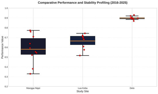
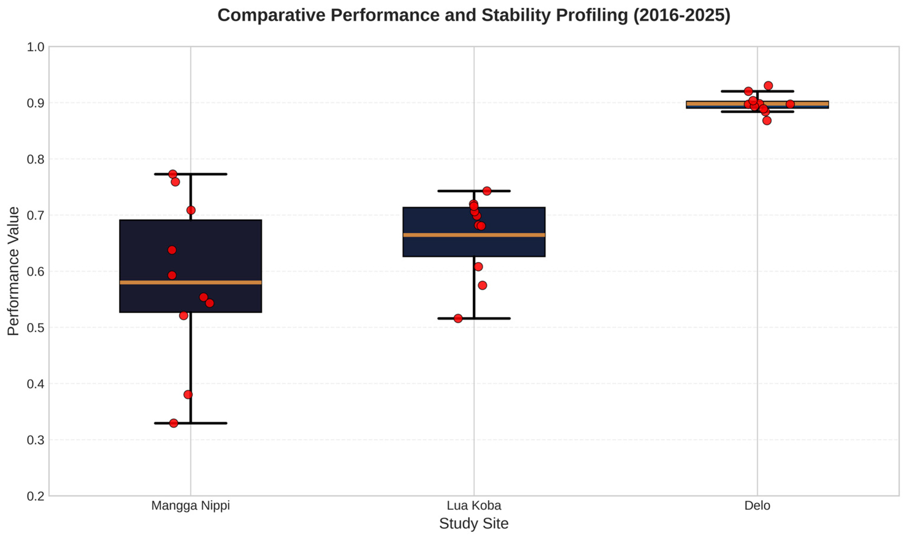
The analysis of NDVI performance across the three study sites from 2016 to 2025 revealed distinct patterns of vegetation productivity and ecological stability (Figure 3). These visual trends are further validated by the CV, which provides a critical numerical measure of inter-annual variability.
Figure 3.
Spatiotemporal NDVI consistency (2016–2025) for Mangga Nippi, Lua Koba, and Delo. Each box plot represents the distribution of annual mean NDVI values (n = 10 years per site), where each annual mean was calculated by averaging all valid pixels within the site boundary. Median, interquartile range (IQR), and annual variations are shown. The red points represent the individual annual mean NDVI values for each site (n = 10 years, 2016–2025), overlaid on the box plot to show the underlying data distribution from which the median, IQR, and whiskers were derived.
Delo consistently outperformed the other locations, maintaining the highest vegetation density with a median NDVI value of approximately 0.90. The box plot shows that Delo has a narrow interquartile range (IQR) and low variance, resulting in a CV value of 1.96%, the lowest among the sites. This indicates that vegetation cover remained relatively consistent throughout the ten-year observation period.
The temporal consistency of vegetation cover at Delo is closely associated with strict traditional monitoring mechanisms and local customary laws. Field interviews indicate that community compliance is strongly reinforced by the perceived spiritual consequences of environmental transgression. Rather than relying solely on material sanctions, the customary framework imposes significant social and spiritual penalties for unauthorised resource extraction, such as harvesting timber without the traditional chief’s ritual approval. This belief system may function as an informal governance mechanism, fostering high community adherence to forest protection protocols.
In contrast, Mangga Nippi and Lua Koba displayed lower overall productivity and higher sensitivity to environmental changes. Lua Koba maintained a moderate NDVI median of 0.69, showing a relatively balanced distribution but greater variability than Delo. Mangga Nippi emerged as the most unstable site, characterised by the widest distribution of data points and a median NDVI of 0.57. This visual dispersion in the box plot is numerically confirmed by Mangga Nippi’s CV percentage (26.54%), which was the highest among all observed sites. Notably, Mangga Nippi recorded significant downward fluctuations with values dropping to approximately 0.33 in specific years, suggesting a high vulnerability to seasonal stressors or external disturbances.
Overall, the correlation between ground-truth qualitative data and these satellite spectral indices confirms that while Lua Koba appears to be undergoing a phase of positive succession, Mangga Nippi is in a phase of active environmental degradation that requires immediate conservation attention. To contextualise these findings, the following account is based on qualitative field observations and informant interviews and is offered to interpret, not to quantitatively demonstrate, the NDVI pattern observed at Lua Koba. Qualitative field observations suggest this trend at Lua Koba stems from a longstanding local regulation, established when the community recognised the threat of gradual forest loss. This regulation mandates the cultivation of productive species on idle private land, explicitly aiming to redirect resource extraction away from the state-protected forest. Enforced by the village chief, this policy has led to the development of multi-strata agroforestry systems. By cultivating diverse species, specifically high-value cash crops like candlenut and cashew, alongside timber trees (teak, mahogany), perennial palms (coconut, areca), and understorey crops (coffee, banana), residents have created vegetation structures that mimic natural forests, similar to multi-strata agroforestry systems documented in tropical regions [45]. Crucially, these private plantations appear to provide ecological benefits, such as carbon sequestration, water regulation, and soil conservation, while generating diversified household income, consistent with the multifunctional role of agroforestry-based ecosystem services [46]. Consequently, this alternative livelihood strategy likely reduces pressure on the protected forest, creating conditions more favourable for its natural recovery.
3.2. Results of CCS and Biophysical Parameters
Composite CCS values are reported descriptively across sites due to the key-informant design. Rating reliability appears supported by Fleiss’ kappa and Cronbach’s alpha values. The analysis reveals notable variations in cultural compliance across the three study sites. Delo achieved the highest composite score of 79.78%, suggesting strong customary adherence. Mangga Nippi and Lua Koba recorded lower scores of 42.15% and 58.30% respectively. These lower scores appear to reflect transitional and declining levels of cultural compliance (Table 2).
Table 2.
Comparative analysis of cultural compliance and ecosystem integrity indicators across the three study sites.
3.3. Rater Consensus Profile and CCS
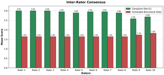
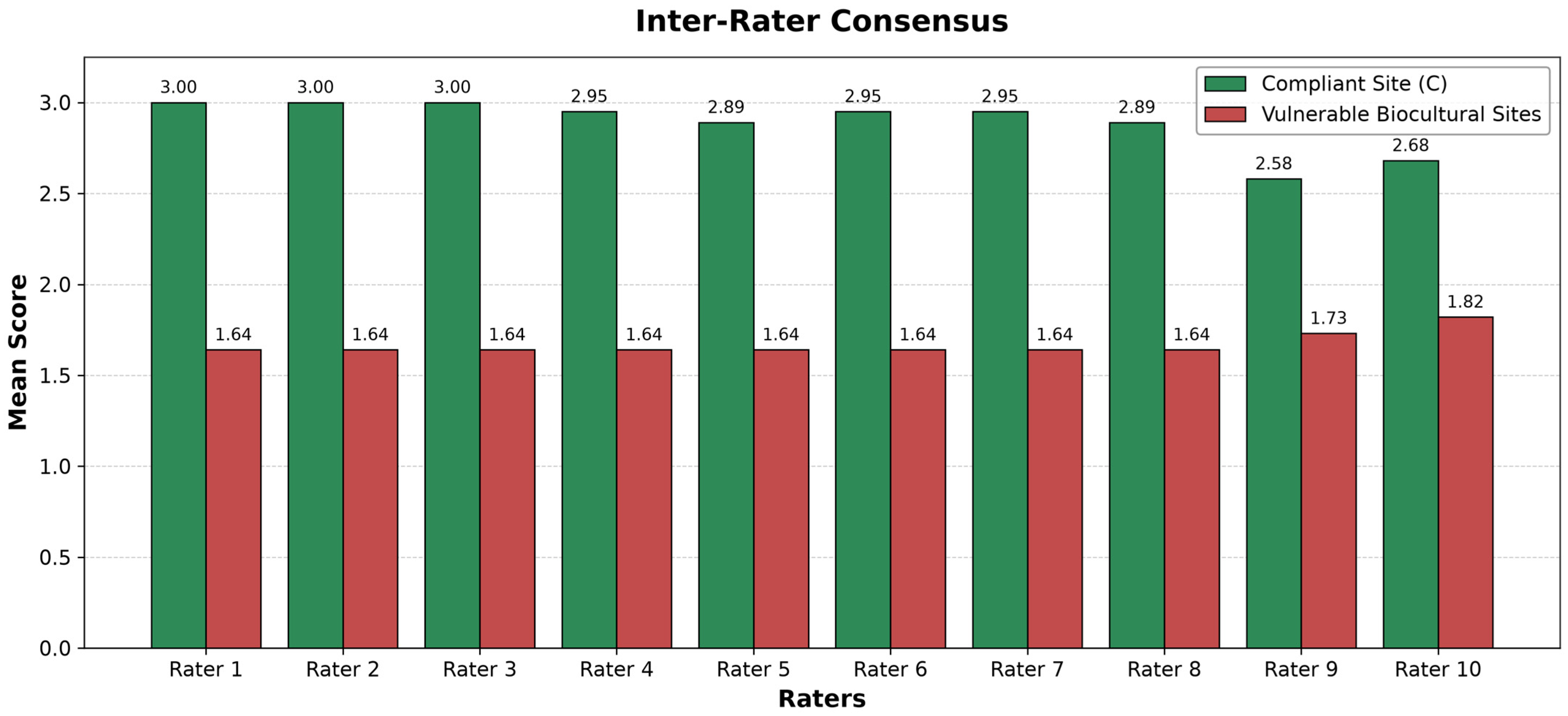
The grouped bar chart in Figure 4 illustrates the inter-rater consensus on lende ura cultural integrity scores, as evaluated by ten raters comprising traditional leaders, academics, and environmental practitioners. Statistical analysis indicates substantial agreement (Fleiss’ Kappa = 0.7710), good consistency (ICC = 0.8718), and robust reliability (Cronbach’s Alpha = 0.8682), supporting the validity of the CCS methodology. Cumulatively, the study area recorded a composite CCS of 79.78%; however, the chart reveals a marked divergence between the two categories of sites. Sites classified as compliant, represented by green bars, consistently achieve scores approaching the maximum value across most dimensions, reflecting the sustained integrity of their traditional philosophy and practices. Conversely, sites experiencing cultural erosion (vulnerable biocultural sites), indicated by red bars, exhibit substantially lower scores.
Figure 4.
Grouped bar chart showing inter-rater consensus on lende ura cultural integrity scores from ten raters. Green bars represent the compliant sites, while red bars indicate vulnerable biocultural sites. Statistical analysis indicates substantial agreement (Fleiss’ Kappa = 0.7710), good consistency (ICC = 0.8718), and robust reliability (Cronbach’s Alpha = 0.8682), supporting the CCS methodology (composite CCS = 79.78%).
At the compliant site, all compliance parameters fall into the high category. At this site, the effectiveness of the lende ura conservation protocol is empirically positively correlated with the strengthening of ecosystem resilience, as indicated by an overall improvement in NDVI.
3.4. Perceived Socio-Cultural Diversity
The FGD revealed a critical consensus regarding the socio-cultural landscape of Southwest Sumba, which is characterised as a complex mosaic of diverse indigenous communities.
“People say that Sumba is home to many ethnic groups (Kodi, Loura, Wewewa, etc.), so it cannot be reduced to a single set of customs.”
4. Discussion
4.1. Ecosystem Health Status as a Manifestation of Socio-Cultural Interactions with the Environment
The vegetation conditions at Delo, characterised by consistently high NDVI values (regularly above 0.85), suggest a dense canopy with high chlorophyll content, which is typically associated with mature forest ecosystems. Furthermore, the low CV suggests temporal consistency in vegetation structure. This pattern indicates that the vegetation tends to retain its integrity despite inter-annual variations. Such stability may be supported by intrinsic hydraulic strategies. Research by [47] indicates that ‘drought tolerators’ tend to maintain higher biomass in stable environments across soil water gradients. These strategies may help maintain productivity through efficient resource use, including during periods of environmental stress.
At Mangga Nippi, the observed temporal variability in NDVI suggests recurring environmental disturbances. Periods of declining NDVI may be associated with reductions in canopy cover, potentially attributable to unregulated resource extraction or land-use changes [43]. However, we acknowledge that this study did not conduct direct land-cover change validation through high-resolution satellite imagery or field surveys. Therefore, while the patterns are consistent with degradation processes, the specific drivers (e.g., logging, agricultural expansion) cannot be definitively identified without further empirical investigation. The apparent lack of natural succession recovery at Mangga Nippi suggests that the ecosystem has experienced frequent external perturbations that may have prevented stabilisation over the observation period.
Lua Koba exhibits a positive NDVI trajectory that may suggest apparent revegetation across the landscape. This increasing trend could correspond to ongoing land rehabilitation initiatives documented in the prior literature [48]. However, the ecosystem at Lua Koba remains less developed than the mature forest at Delo despite these improvements. Confirming ecological recovery would require species composition, forest structure, and regeneration data not collected in this study. The mean NDVI score remains at 0.66 throughout the observation period.
The marked difference in stability across sites is relevant to environmental management. Addressing this degradation at Mangga Nippi would require active restoration. Lua Koba, in the interim, would benefit from continued protection. As observed at previously stabilised sites, this would allow the succession process to progress toward its climax stage. Recent research in tropical dry ecosystems by [49] suggests that formal protection status may be associated with ecosystem functionality. This factor appears to outweigh inherent biome differences in certain contexts. Such systems may exhibit a form of elastic resilience. They tend to maintain stability until anthropogenic disturbances exceed certain thresholds. Examples include substantial woody biomass removal, which may trigger notable vegetation decline. This pattern may help interpret the observed conditions at Mangga Nippi. It may also relate to the potential recovery trajectory observed in Lua Koba.
4.2. Social Capital and Cultural Resilience: Manifestations of Spirituality in Forest Conservation
The CCS analysis indicates that Delo exhibits the highest observed cultural compliance, aligning closely with biocultural conservation principles. In this community, forest protection appears intertwined with the lende ura philosophy. It often functions as a spiritual obligation alongside formal regulatory requirements. Local perspectives incorporate belief systems that may act as informal social control mechanisms. Traditional beliefs regarding spiritual consequences may help deter unregulated resource extraction. Such local beliefs may complement formal state enforcement mechanisms [13]. Accessing timber often involves adherence to customary protocols and traditional leader approval. This customary governance may contribute to the relatively consistent NDVI at Delo. This pattern persists despite the limited presence of formal forest rangers. These observations suggest complex conservation dynamics across different regions in Sumba. At Mangga Nippi, vegetation changes occurred within the state forest designation. These changes may reflect varying local governance contexts in the area. Conversely, the lende ura philosophy at Delo appears to support dense vegetation. This study did not quantitatively evaluate formal legal enforcement intensity levels. However, patterns suggest local customary practices may complement formal land status.
The community conceptualises the forest as a ‘Rain Bridge’ for land-use decisions. This concept may restrict intensive cultivation within the sacred forest core. Consequently, agricultural activities are often directed toward nearby outer buffer zones. This dedication to conservation may be observed through the traditional kaliwu system. This agroforestry approach often functions as a valuable multi-purpose buffer zone. Cultivating mixed-use gardens may help local communities meet economic needs sustainably. This practice potentially reduces direct encroachment on the primary forest areas. The lende ura philosophy and kaliwu agroforestry form a social–ecological system. Within this framework, users tend to self-organise for vital resource management. According to [50], sustainability may be supported through greater community autonomy. Collective-choice rules can align with local ecological conditions and cultural norms. Intertwining spiritual obligations with adaptive strategies may lower monitoring costs [51]. This approach potentially fosters long-term ecological resilience alongside formal state regulation.
In contrast, Mangga Nippi exhibits a notable reduction in its CCS profile. Modernisation and economic pressures appear to weaken customary deterrence, contributing to biocultural divergence. The distinction between managed and protected areas blurs as traditional belief systems decline. NDVI results indicate that this shift is associated with notable vegetation deterioration. Theoretically, the breakdown of shared resource governance occurs when customary institutions fail to adapt, leading to a loss of social control [52]. Conversely, Lua Koba demonstrates observable vegetation recovery with increasingly dense cover in NDVI data. This trend is associated with a longstanding local regulation, established in response to gradual forest loss, which mandates the cultivation of productive species on idle private land. The explicit purpose of this rule is to redirect resource extraction away from the state-protected forest. The village chief has consistently enforced this policy with sanctions for non-compliance. Despite initial resistance to this mandate, the community now acknowledges its dual benefits. By cultivating diverse species, specifically high-value cash crops like candlenut and cashew, alongside timber trees (teak, mahogany), perennial palms (coconut, areca), and understorey crops (coffee, banana), residents have developed multi-strata agroforestry systems that mimic forest structure. These private plantations contribute to ecosystem functions, including carbon sequestration, water regulation, and soil conservation, while simultaneously generating diversified household income. Consequently, the community has reduced its reliance on exploiting the protected forest, associated with a positive NDVI trajectory at Lua Koba.
4.3. The Economic Burden and the Vicious Circle of Poverty
The economic implications of environmental degradation in Mangga Nippi and Lua Koba represent a notable finding of this study. Qualitative data from household interviews indicate that families in these sites now incur costs of up to IDR 500,000 (approximately USD 32) per month to meet basic water needs, following the disappearance of natural water sources. Consistent with previous socio-economic assessments in similar marginal areas, this represents a substantial financial burden for communities with limited educational attainment and irregular income streams [53]. In contrast, the community in Delo, which continues to uphold the lende ura philosophy, maintains direct access to natural springs. This contrast suggests that traditional conservation practices may serve as a vital strategy for local economic resilience.
This circumstance may reflect conditions consistent with a poverty–environment trap framework [54]. This concept describes a reinforcing cycle where resource depletion corresponds to intensified local poverty. Such conditions may subsequently relate to further unsustainable resource extraction across the landscape. At Mangga Nippi, environmental violations appear concurrent with severe local economic distress [55]. These patterns suggest that targeted interventions would need to address specific socio-economic vulnerabilities across the site [56]. Furthermore, limited access to alternative livelihoods may compound these observed local vulnerabilities [54]. However, our quantitative socio-economic evidence is limited to reported monthly household water-access costs. Income, expenditure, and formal poverty metrics were not systematically measured across the study sites. The poverty–environment trap is therefore offered as an interpretive framing consistent with the prior literature.
4.4. Hydrological Resilience and Ecological Justice
The relationship between vegetation and the water cycle at the study site is understood by the local community not merely as a natural phenomenon, but as a ‘bridge of life’.
“Lende ura means ‘Rain Bridge’. If the forest is destroyed, the rain will stop falling, so the bridge in question is the forest itself; the place where the rain falls. This is a teaching from our ancestors that we have upheld to this day. Were it not for this rule, our forest might well have been completely destroyed by now”.(Informant 7)
The alignment between satellite data and local perceptions is confirmed by the philosophy of lende ura, which the local community interprets technically as the ‘Rain Bridge’. This concept emphasises the role of the forest as biological infrastructure that ensures the sustainability of the hydrological cycle.
The observed pattern at Delo shows high CCS alongside temporally consistent NDVI values (Table 3). Informant reports also indicate continued access to natural springs in this area. These observations align with prior literature suggesting that dense vegetation supports hydrological regulation [57].
Table 3.
Relationship between land cover dynamics and hydrological resilience across the three study sites (2016–2025).
4.5. Navigating Biocultural Pluralism and Social Equity
Results from our FGDs reveal that, although the lende ura philosophy is empirically successful, it operates within a plural socio-cultural landscape: diverse ethnic groups such as the Kodi and Loura possess distinct ancestral mandates and linguistic nuances. This plurality reflects the concept of biocultural diversity, where biological, cultural, and linguistic manifestations are viewed as interrelated components of a complex adaptive system [58]. Consequently, positioning the lende ura philosophy as a universal mandate may pose a risk of social inequity. There is a concern that if official recognition were to be standardised into a single customary structure, it might inadvertently marginalise communities whose unique traditions do not align with this specific model.
These challenges highlight the analytical relevance of an inclusive, decentralised approach to recognition, in which local government would act as a facilitator rather than a centralised authority. This approach allows conservation strategies to move beyond ‘top-down’ uniformity, enabling each community to manage its territory according to its specific ancestral values. By respecting these distinct manifestations, such a framework may foster a sustainable ‘unity in diversity’ that safeguards the rights and traditional knowledge of all community members.
Because decentralisation may not automatically guarantee equitable empowerment, it could risk elite capture by dominant local figures [59], so any such arrangement would require layered accountability transparent community forums and social audits that give women, youth, and marginalised groups a role in decision-making and resource monitoring [52], with local government and civil society acting as independent observers. This is raised as an implication of the observed pattern rather than a prescribed governance model.
While discussing these socio-cultural drivers, it is essential to consider the potential influence of physical geography. Although topography may influence NDVI through water distribution and accessibility, the notable difference in NDVI values between Delo (0.90) and Mangga Nippi (0.58) suggests that slope characteristics alone may not fully explain the observed patterns. Theoretically, steeper slopes in semi-arid regions like Southwest Sumba are often associated with higher erosion rates, which typically correspond to lower NDVI values. The relatively high NDVI at Delo suggests a potential interaction between cultural and environmental factors. Traditional protection associated with the lende ura philosophy appears to work alongside topographic conditions. This combination may support environments where plant functional traits tend to use resources efficiently. Research by [49] indicates that vegetation productivity across soil water gradients is shaped by intrinsic hydraulic strategies, with drought avoiders enhancing resource efficiency in drier microsites and drought tolerators accumulating greater biomass in wetter ones.
4.6. Ecological and Conservation Implications
As an exploratory consideration, the observed association suggests that community-based PES might warrant further investigation. This framing is offered as a conceptual possibility rather than a validated policy recommendation. To mitigate the risk of ‘perverse incentives’, a phenomenon well-documented in recent evaluations of the EU Common Agricultural Policy [60], a community-based PES (CB-PES) approach may be more appropriate than individualised models in this context. In such a framework, incentives facilitated by governmental or private initiatives could be structured around collective outcomes. By directing benefits toward communal goals, such as supporting traditional conservation ceremonies or community-led forest patrols, such schemes could draw on existing social cohesion and customary governance to reduce the likelihood of ‘free-riding’ [61].
The observed temporal consistency in late dry-season NDVI at Delo suggests that customary governance practices may play a role in maintaining contiguous vegetation cover. This structural continuity is ecologically significant, as it likely facilitates landscape connectivity and provides stable microhabitats that can support local biodiversity, even during periods of peak drought stress. While NDVI alone does not measure species richness, the preservation of a consistent vegetation baseline indicates a reduced risk of habitat fragmentation, which is a critical factor for the long-term viability of local ecosystems in marginal drylands.
A balanced framework would also treat these socio-economic considerations as complementary to, rather than a replacement for, the protection of natural habitats [62]. In these areas, passive restoration and natural regeneration, which allow ecological dynamics to proceed with minimal anthropogenic influence, are increasingly recognised as essential and cost-effective strategies for long-term resilience [63]. Ultimately, involving local customary institutions in the design and monitoring of these schemes could help ensure that economic incentives support, rather than undermine, long-term ecological integrity.
4.7. Limitations
This study provides empirical evidence linking cultural compliance with vegetation dynamics. However, several methodological limitations must be openly acknowledged. First, reliance on NDVI as a key biophysical proxy does not capture ecosystem multidimensionality. The index does not directly measure biodiversity, carbon stocks, or hydrological functioning. Observed patterns therefore indicate vegetation structural consistency rather than holistic ecological health. Second, the three study sites exhibit inherent topographical variations in elevation and slope. These variations may act as confounding variables influencing soil moisture retention. Quantitative terrain analysis using Digital Elevation Models was not employed in this study. Future research could incorporate DEM-based analysis alongside direct field measurements. Third, reliance on only three purposively selected case-study sites restricts generalisability. This limitation prevents statistical separation of cultural compliance from co-varying environmental factors. Fourth, the observational and comparative design can identify associations but cannot establish causation. Finally, the CCS is based on a small key-informant panel using a three-point scale. This approach constrains statistical generalisation despite acceptable reliability scores. Despite these limitations, the study provides a foundational empirical basis for understanding biocultural dynamics in tropical drylands. The observed associations offer a replicable methodological framework and generate testable hypotheses for future research with larger sample sizes.
5. Conclusions
Our findings demonstrate notable associations between cultural integrity and vegetation dynamics across three sites in Southwest Sumba over the observation period 2016–2025. In Delo, the active practice of the lende ura protocol exhibited the strongest cultural compliance alongside the most stable vegetation cover. Conversely, Mangga Nippi is undergoing a cultural and economic transition, a condition associated with notable ecological vulnerability and high temporal instability in vegetation. Meanwhile, Lua Koba illustrates a positive recovery trajectory, where community-based agroforestry appears to alleviate pressure on the forest. Building upon these empirical links, the CCS and NDVI consistency metrics developed in this study could serve as operational tools for future investigations. These metrics may help identify eligible communities and explore community-based PES frameworks as a conceptual model for conservation. This approach could align traditional conservation practices with livelihood support, ultimately offering a pathway to reduce socio-economic pressures on forest ecosystems, whilst acknowledging the correlational nature of the evidence.
Supplementary Materials
The following supporting information can be downloaded at: https://www.mdpi.com/article/10.3390/conservation6030102/s1, File S1: Questionnaire; File S2: NDVI Annual Mean; File S3: Rater Score.
Author Contributions
Conceptualization, S.B. and W.H.; methodology, S.B.; software, B.A.; validation, A.M., J.T. and J.P.; formal analysis, S.B.; investigation, S.B., M.N.S. and A.R.; resources, S.B.; data curation, B.A. and A.R.; writing—original draft preparation, S.B., W.H., B.A., A.M., J.T., J.P., M.N.S. and A.R.; writing—review and editing, S.B., W.H., B.A., R.S. (Rosidin Sudastro), A.M., J.T., J.P., M.N.S., A.R. and R.S. (Rachmini Saparita); visualization, S.B.; supervision, W.H. and R.S. (Rosidin Sudastro); project administration, S.B. All authors have read and agreed to the published version of the manuscript.
Funding
This research was funded by the National Research and Innovation Agency (BRIN), Indonesia.
Institutional Review Board Statement
The study was conducted in accordance with the Declaration of Helsinki and approved by the Ethics Committee of the National Research and Innovation Agency (protocol code number: 349/KE.01/SK/06/2023; date of approval: 5 June 2023).
Informed Consent Statement
Informed consent was obtained from all subjects involved in the study.
Data Availability Statement
The data presented in this study are available on request from the corresponding author. The data are not publicly available due to privacy restrictions regarding traditional ecological knowledge and household-level information.
Acknowledgments
The authors would like to express their sincere gratitude to the traditional leaders and local communities in the research sites for their permission, hospitality, and the invaluable information provided regarding the lende ura system. We also thank all parties who contributed their expertise and support throughout the field data collection.
Conflicts of Interest
The authors declare no conflicts of interest.
References
- HuMa. Where Will Indonesial Forest Be Take To? Available online: https://www.huma.or.id/en/law-reform/where-will-indonesian-forests-be-taken-to (accessed on 23 October 2025).
- Njurumana, G.N.; Ginoga, K.; Octavia, D. Sustaining Farmers Livelihoods through Community Forestry in Sikka, East Nusa Tenggara, Indonesia. Biodiversitas 2020, 21, 3786–3796. [Google Scholar] [CrossRef] [Scilit]
- Yumantoko; Al Hasan, R.; Wahyono, E.; Wicaksono, A.; Agustine, R.; Ishak, A.; Manan, A. Income Contribution from Forest Honey: Digital Era Opportunities for Economic and Environmental Sustainability in Sumbawa. IOP Conf. Ser. Earth Environ. Sci. 2025, 1438, 012033. [Google Scholar] [CrossRef] [Scilit]
- Sibelet, N.; Posada, K.E.; Gutiérrez-Montes, I.A. Agroforestry Systems Provide Firewood for Livelihood Improvement in Guatemala. Bois For. Trop. 2019, 340, 91–102. [Google Scholar] [CrossRef] [Scilit]
- Brodie, J.; Post, E.; Laurance, W.F. Climate Change and Tropical Biodiversity: A New Focus. Trends Ecol. Evol. 2012, 27, 145–150. [Google Scholar] [CrossRef] [Scilit] [PubMed]
- Pagiola, S. Land Use Change in Indonesia; Background Paper Prepared for the Environment Department; World Bank: Washington, DC, USA, 2000. [Google Scholar]
- Demichelis, C.; Oszwald, J.; Mckey, D.; Essono, P.-Y.B.; Sounguet, G.-P.; Braun, J.-J. Socio-Ecological Approach to a Forest-Swamp-Savannah Mosaic Landscape Using Remote Sensing and Local Knowledge: A Case Study in the Bas-Ogooué Ramsar Site, Gabon. Environ. Manag. 2023, 72, 1241–1258. [Google Scholar] [CrossRef] [Scilit] [PubMed]
- Murphy, B.P.; Bowman, D.M.J.S. What Controls the Distribution of Tropical Forest and Savanna? Ecol. Lett. 2012, 15, 748–758. [Google Scholar] [CrossRef] [Scilit] [PubMed]
- Fowler, C. The Ecological Implications of Ancestral Religion and Reciprocal Exchange in a Sacred Forest in Karendi (Sumba, Indonesia). Worldviews 2003, 7, 303–329. [Google Scholar] [CrossRef] [Scilit]
- Nugroho, H.Y.S.H.; Sallata, M.K.; Allo, M.K.; Wahyuningrum, N.; Supangat, A.B.; Setiawan, O.; Njurumana, G.N.; Isnan, W.; Auliyani, D.; Ansari, F.; et al. Incorporating Traditional Knowledge into Science-Based Sociotechnical Measures in Upper Watershed Management: Theoretical Framework, Existing Practices and the Way Forward. Sustainability 2023, 15, 3502. [Google Scholar] [CrossRef] [Scilit]
- Sullivan, M.K.; Browne, L.; Penagos Zuluaga, J.C.; Liu, J.; Surendra, A.; Estrada-Villegas, S. Sacred Forest Biodiversity Conservation: A Meta-analysis. Conserv. Sci. Pract. 2024, 6, e13055. [Google Scholar] [CrossRef] [Scilit]
- Pascual, U.; Balvanera, P.; Díaz, S.; Pataki, G.; Roth, E.; Stenseke, M.; Watson, R.T.; Dessane, E.B.; Islar, M.; Kelemen, E.; et al. Valuing Nature’s Contributions to People: The IPBES Approach. Curr. Opin. Environ. Sustain. 2017, 26, 7–16. [Google Scholar] [CrossRef] [Scilit]
- Reyes-García, V.; Fernández-Llamazares, Á.; McElwee, P.; Molnár, Z.; Öllerer, K.; Wilson, S.J.; Brondizio, E.S. The Contributions of Indigenous Peoples and Local Communities to Ecological Restoration. Restor. Ecol. 2019, 27, 3–8. [Google Scholar] [CrossRef] [Scilit]
- Carr, D. Population and Deforestation: Why Rural Migration Matters. Prog. Hum. Geogr. 2009, 33, 355–378. [Google Scholar] [CrossRef] [Scilit] [PubMed]
- Hosonuma, N.; Herold, M.; De Sy, V.; De Fries, R.S.; Brockhaus, M.; Verchot, L.; Angelsen, A.; Romijn, E. An Assessment of Deforestation and Forest Degradation Drivers in Developing Countries. Environ. Res. Lett. 2012, 7, 044009. [Google Scholar] [CrossRef] [Scilit]
- López-Carr, D. A Review of Small Farmer Land Use and Deforestation in Tropical Forest Frontiers: Implications for Conservation and Sustainable Livelihoods. Land 2021, 10, 1113. [Google Scholar] [CrossRef] [Scilit]
- Ngongo, Y.; de Rosari, B.; Basuki, T.; Njurumana, G.N.; Nugraha, Y.; Harianja, A.H.; Ardha, M.; Kustiyo, K.; Shofiyati, R.; Heryanto, R.B.; et al. Land Cover Change and Food Security in Central Sumba: Challenges and Opportunities in the Decentralization Era in Indonesia. Land 2023, 12, 1043. [Google Scholar] [CrossRef] [Scilit]
- Vijayan, D.; Kaechele, H.; Girindran, R.; Chattopadhyay, S.; Lukas, M.C.; Arshad, M. Tropical Forest Conversion and Its Impact on Indigenous Communities Mapping Forest Loss and Shrinking Gathering Grounds in the Western Ghats, India. Land Use Policy 2021, 102, 105133. [Google Scholar] [CrossRef] [Scilit]
- Eriksson, H.; Blythe, J.L.; Österblom, H.; Olsson, P. Beyond Social-Ecological Traps: Fostering Transformations towards Sustainability. Ecol. Soc. 2021, 26, 528. [Google Scholar] [CrossRef] [Scilit]
- Cusens, J.; Barraclough, A.D.; Måren, I.E. Socio-Cultural Values and Biophysical Supply: How Do Afforestation and Land Abandonment Impact Multiple Ecosystem Services? Land Use Policy 2024, 136, 106967. [Google Scholar] [CrossRef] [Scilit]
- Pluye, P.; Grad, R.M.; Levine, A.; Nicolau, B. Understanding Divergence of Quantitative and Qualitative Data (or Results) in Mixed Methods Studies. Int. J. Mult. Res. Approaches 2009, 3, 58–72. [Google Scholar] [CrossRef] [Scilit]
- SIGAP. Peta Interaktif SIGAP Kementerian Kehutanan. Available online: https://geoportal.planologi.kehutanan.go.id/portal/apps/experiencebuilder/experience/?id=46d3d0cc19504604ade2064c7341d2c2 (accessed on 11 December 2025).
- NASA POWER. Dataset. Available online: https://power.larc.nasa.gov/data-access-viewer/ (accessed on 10 December 2025).
- Stasiun Meteorologi Umbu Mehang Kunda—BMKG Sumba. Buletin Meteorologi: Analisis Cuaca Januari 2023 dan Prakiraan Cuaca Februari 2023; Badan Meteorologi, Klimatologi, dan Geofisika (BMKG): Waingapu, Indonesia, 2023.
- Boer, M.M.; Puigdefábregas, J. Predicting Potential Vegetation Index Values as a Reference for the Assessment and Monitoring of Dryland Condition. Int. J. Remote Sens. 2003, 24, 1135–1141. [Google Scholar] [CrossRef] [Scilit]
- Nugroho, H.; Sari, D.K.; Baihaqi, T. Detection Of Land Drought Using Landsat Imagery On The Google Earth Engine Platform For Forest Fire Mitigation. ELKOMIKA J. Tek. Energi Elektr. Tek. Telekomun. Tek. Elektron. 2024, 12, 1023. [Google Scholar] [CrossRef] [Scilit]
- Caldas, M.P. Research Design: Qualitative, Quantitative, and Mixed Methods Approaches. Rev. Adm. Contemp. 2003, 7, 223. [Google Scholar] [CrossRef] [Scilit]
- Planet Insights. Planet Insights Platform Browser. Available online: https://insights.planet.com/analyze/browser (accessed on 24 December 2025).
- Noble, H.; Heale, R. Triangulation in Research, with Examples. Evid. Based Nurs. 2019, 22, 67–68. [Google Scholar] [CrossRef] [Scilit] [PubMed]
- Armond, T. Joyce Procedures for Gathering Ground Truth Information for a Supervised Approach to a Computer Implemented Land Cover Classification of Landsat Acquired Multispectral Scanner Data; NASA Earth Resources Laboratory: St. Louis, MS, USA, 1977.
- O. Nyumba, T.; Wilson, K.; Derrick, C.J.; Mukherjee, N. The Use of Focus Group Discussion Methodology: Insights from Two Decades of Application in Conservation. Methods Ecol. Evol. 2018, 9, 20–32. [Google Scholar] [CrossRef] [Scilit]
- Piza, I.; Velásquez, M.; Remache, J.; Abdurashidova, M. Neutrosophic Likert Scale for Evaluating Environmental Sanctions. Int. J. Neutrosophic Sci. 2024, 24, 24–34. [Google Scholar] [CrossRef] [Scilit]
- Fleiss, J.L.; Cohen, J.; Everitt, B.S. Large Sample Standard Errors of Kappa and Weighted Kappa. Psychol. Bull. 1969, 72, 323. [Google Scholar] [CrossRef] [Scilit]
- Landis, J.R.; Koch, G.G. An Application of Hierarchical Kappa-type Statistics in the Assessment of Majority Agreement among Multiple Observers. Biometrics 1977, 33, 363–374. [Google Scholar] [CrossRef] [Scilit]
- Moons, F.; Vandervieren, E. Measuring Agreement among Several Raters Classifying Subjects into One or More (Hierarchical) Categories: A Generalization of Fleiss’ Kappa. Behav. Res. Methods 2025, 57, 287. [Google Scholar] [CrossRef] [Scilit] [PubMed]
- Erasmi, S.; Klinge, M.; Dulamsuren, C.; Schneider, F.; Hauck, M. Modelling the Productivity of Siberian Larch Forests from Landsat NDVI Time Series in Fragmented Forest Stands of the Mongolian Forest-Steppe. Environ. Monit. Assess. 2021, 193, 200. [Google Scholar] [CrossRef] [Scilit] [PubMed]
- Reid, S.L.; Walker, J.L.; Schaaf, A. Using Multi-Spectral Landsat Imagery to Examine Forest Health Trends at Fort Benning, Georgia. In Proceedings of the 18th Biennial Southern Silvicultural Research Conference; US Department of Agriculture, Forest Service, Southern Research Station: Asheville, NC, USA, 2016; Volume 212, pp. 601–603. [Google Scholar]
- Jaramillo, E.; Portnoy, I.; Torregroza-Espinosa, A.C.; Larios-Giraldo, P. Evolution of the Landscape’s Vegetation Health Condition in a Tropical Coastal Lagoon: A Remote Sensing Study in the Case of Northern Colombia. Procedia Comput. Sci. 2024, 231, 526–531. [Google Scholar] [CrossRef] [Scilit]
- De Keersmaecker, W.; Lhermitte, S.; Hill, M.; Tits, L.; Coppin, P.; Somers, B. Assessment of Regional Vegetation Response to Climate Anomalies: A Case Study for Australia Using GIMMS NDVI Time Series between 1982 and 2006. Remote Sens. 2017, 9, 34. [Google Scholar] [CrossRef] [Scilit]
- Brown, C.E. Coefficient of Variation. In Applied Multivariate Statistics in Geohydrology and Related Sciences; Springer: Berlin/Heidelberg, Germany, 1998; pp. 155–157. [Google Scholar]
- Vandandorj, S.; Gantsetseg, B.; Boldgiv, B. Spatial and Temporal Variability in Vegetation Cover of Mongolia and Its Implications. J. Arid. Land 2015, 7, 450–461. [Google Scholar] [CrossRef] [Scilit]
- Rees, M.; Condit, R.; Crawley, M.; Pacala, S.; Tilman, D. Long-Term Studies of Vegetation Dynamics. Science 2001, 293, 650–655. [Google Scholar] [CrossRef] [Scilit] [PubMed]
- Borini Alves, D.; Pérez-Cabello, F.; Rodrigues Mimbrero, M. Land-Use and Land-Cover Dynamics Monitored by NDVI Multitemporal Analysis in a Selected Southern Amazonian Area (Brazil) for the Last Three Decades. ISPRS-Int. Arch. Photogramm. Remote Sens. Spat. Inf. Sci. 2015, XL-7/W3, 329–335. [Google Scholar] [CrossRef] [Scilit]
- Daniel, D.; Satriani, S.; Zudi, S.L.; Ekka, A. To What Extent Does Indigenous Local Knowledge Support the Social–Ecological System? A Case Study of the Ammatoa Community, Indonesia. Resources 2022, 11, 106. [Google Scholar] [CrossRef] [Scilit]
- Negash, M.; Kaseva, J.; Kahiluoto, H. Determinants of Carbon and Nitrogen Sequestration in Multistrata Agroforestry. Sci. Total. Environ. 2022, 851, 158185. [Google Scholar] [CrossRef] [Scilit] [PubMed]
- van Noordwijk, M. Agroforestry-Based Ecosystem Services. Land 2021, 10, 770. [Google Scholar] [CrossRef] [Scilit]
- Chaturvedi, R.K.; Pandey, S.K.; Tripathi, A.; Goparaju, L.; Nath, A.J.; Raghubanshi, A.S.; Gupta, S.R.; Singh, J.S. Disturbance Mediated Changes in Litter Turnover and Nutrient Use Efficiency Facilitate Vegetation Shifts in Tropical Dry Ecosystems: Insights from a 10-year Vegetation Management Study. Land Degrad. Dev. 2025, 37, 3652–3672. [Google Scholar] [CrossRef] [Scilit]
- Turner, D.; Clarke, K.; Lewis, M.; Ostendorf, B. Using NDVI Dynamics as an Indicator of Native Vegetation Management in a Heterogeneous and Highly Fragmented Landscape. In Proceedings of the 20th International Congress on Modelling and Simulation, Adelaide, SA, Australia, 1–6 December 2013; Modelling and Simulation Society of Australia and New Zealand: Canberra, Australia, 2013. [Google Scholar]
- Chaturvedi, R.K.; Tomlinson, K.W.; Pandey, S.K.; Tripathi, A.; Raghubanshi, A.S.; Singh, J.S. Changes in Plant Traits and Productivity of Two Functional Types across a Soil Water Content Gradient in a Tropical Dry Forest. J. Ecol. 2025, 113, 3535–3549. [Google Scholar] [CrossRef] [Scilit]
- Ostrom, E. A General Framework for Analyzing Sustainability of Social-Ecological Systems. Science 2009, 325, 419–422. [Google Scholar] [CrossRef] [Scilit] [PubMed]
- Njurumana, G.N.; Sadono, R.; Marsono, D. Irham Ecosystem Services of Indigenous Kaliwu Agroforestry System in Sumba, Indonesia. E3S Web Conf. 2021, 305, 04002. [Google Scholar] [CrossRef] [Scilit]
- Ostrom, E. Governing the Commons: The Evolution of Institutions for Collective Action, 1st ed.; Cambridge University Press: Cambridge, UK, 1990. [Google Scholar]
- Lal, T. Impact of Financial Inclusion on Economic Development of Marginalized Communities through the Mediation of Social and Economic Empowerment. Int. J. Soc. Econ. 2021, 48, 1768–1793. [Google Scholar] [CrossRef] [Scilit]
- Barbier, E.B. Poverty, Development, and Environment. Environ. Dev. Econ. 2010, 15, 635–660. [Google Scholar] [CrossRef] [Scilit]
- Pritchard, R.; Grundy, I.M.; Van Der Horst, D.; Dzobo, N.; Ryan, C.M. Environmental Resources as ‘Last Resort’ Coping Strategies Following Harvest Failures in Zimbabwe. World Dev. 2020, 127, 104741. [Google Scholar] [CrossRef] [Scilit]
- Pretty, J.; Smith, D. Social Capital in Biodiversity Conservation and Management. Conserv. Biol. 2004, 18, 631–638. [Google Scholar] [CrossRef] [Scilit]
- García-Leoz, V.; Villegas, J.C.; Suescún, D.; Flórez, C.P.; Merino-Martín, L.; Betancur, T.; León, J.D. Land Cover Effects on Water Balance Partitioning in the Colombian Andes: Improved Water Availability in Early Stages of Natural Vegetation Recovery. Reg. Environ. Change 2018, 18, 1117–1129. [Google Scholar] [CrossRef] [Scilit]
- Maffi, L. Linguistic, Cultural, and Biological Diversity. Annu. Rev. Anthr. 2005, 34, 599–617. [Google Scholar] [CrossRef] [Scilit]
- Crook, R.C. Decentralisation and Poverty Reduction in Africa: The Politics of Local–Central Relations. Public Adm. Dev. 2003, 23, 77–88. [Google Scholar] [CrossRef] [Scilit]
- Pe’er, G.; Finn, J.A.; Díaz, M.; Birkenstock, M.; Lakner, S.; Röder, N.; Kazakova, Y.; Šumrada, T.; Bezák, P.; Concepción, E.D.; et al. How Can the European Common Agricultural Policy Help Halt Biodiversity Loss? Recommendations by over 300 Experts. Conserv. Lett. 2022, 15, e12901. [Google Scholar] [CrossRef] [Scilit]
- McElwee, P.; Van Le, H.T.; Nghiem, T.; Vu, H.T.D. The Challenges of Collective PES: Insights from Three Community-Based Models in Vietnam. Ecosyst. Serv. 2022, 56, 101438. [Google Scholar] [CrossRef] [Scilit]
- Ullah, F.; Saqib, S.; Qin-Zheng, H.; Xiong, Y. A Framework for Integrative Socioecological Conservation Solutions. Conserv. Biol. 2026, 40, e70237. [Google Scholar] [CrossRef] [Scilit] [PubMed]
- Crouzeilles, R.; Ferreira, M.S.; Chazdon, R.L.; Lindenmayer, D.B.; Sansevero, J.B.; Monteiro, L.; Iribarrem, A.; Latawiec, A.E.; Strassburg, B.B. Ecological Restoration Success Is Higher for Natural Regeneration than for Active Restoration in Tropical Forests. Sci. Adv. 2017, 3, e1701345. [Google Scholar] [CrossRef] [Scilit] [PubMed]

Disclaimer/Publisher’s Note: The statements, opinions and data contained in all publications are solely those of the individual author(s) and contributor(s) and not of MDPI and/or the editor(s). MDPI and/or the editor(s) disclaim responsibility for any injury to people or property resulting from any ideas, methods, instructions or products referred to in the content. |
© 2026 by the authors. Licensee MDPI, Basel, Switzerland. This article is an open access article distributed under the terms and conditions of the Creative Commons Attribution (CC BY) license.