
Article

Unprotected Urban Sand Dunes Under Anthropogenic Pressure and Risk of Habitat Loss: Using UAS–LiDAR Data to Support Conservation Along the Bulgarian Black Sea Coast

1
Institute of Oceanology, Bulgarian Academy of Sciences, 9000 Varna, Bulgaria
2
Institute of Biodiversity and Ecosystem Research, Bulgarian Academy of Sciences, 1113 Sofia, Bulgaria
3
Faculty of Geology and Geography, Sofia University “St. Kliment Ohridski”, 1504 Sofia, Bulgaria
4
Ministry of Environment and Water of the Republic of Bulgaria, 1000 Sofia, Bulgaria
*
Author to whom correspondence should be addressed.
Conservation 2026, 6(2), 50; https://doi.org/10.3390/conservation6020050
Submission received: 5 March 2026 / Revised: 6 April 2026 / Accepted: 13 April 2026 / Published: 21 April 2026

Abstract

Coastal beach–dune systems along the Western Black Sea Coast represent geomorphologically complex and ecologically valuable environments that have been increasingly affected by long-term urbanisation and recreational pressure. This study examines the geomorphological settings, sedimentary connectivity and associated Natura 2000 dune habitats within two urbanised beach–dune systems, Pobeda (Burgas) and Asparuhovo (Varna), to improve their cadastral documentation and support objective conservation assessment. The analysis is based on high-resolution UAS-LiDAR surveys, complemented by UAS photogrammetry and field observations, allowing detailed three-dimensional characterisation of dune landforms, surface morphology and habitat patterns. The results identify foredune-dominated system architectures in both study areas, with the Pobeda (Burgas) and Asparuhovo (Varna) beach–dune systems comprising embryonic dunes, established foredune ridges and low-relief foredune plains, variably developed and spatially fragmented as a result of long-term urbanisation and recreational pressure, and spatially associated with dune habitats. Despite substantial anthropogenic modification, these elements remain recognisable, although locally fragmented and morphologically degraded. Subtle topographic changes related to trampling, informal access routes and surface compaction were detected, particularly affecting foredune crests and foredune plains, with implications for sediment transport continuity and habitat stability. The study shows that conventional habitat inventories alone are insufficient for capturing such changes. Integrated geomorphological and habitat analysis based on UAS-LiDAR provides a reliable framework for accurate mapping, conservation status assessment and informed consideration of coastal dune systems within the Natura 2000 network and related protection schemes.

1. Introduction

Coastal sand dunes are dynamic geomorphological systems that develop at the interface between marine and aeolian environments and function as integral components of the beach–dune system (BDS) [1,2]. Their formation and evolution are governed by sediment supply, wind regime, surface moisture, and vegetation-mediated sediment retention, surface stability, and dune accretion [3,4,5,6]. These interacting controls determine dune morphology, structure, and resilience under changing environmental and anthropogenic conditions [7,8]. Because dunes rely on uninterrupted aeolian sediment transport between the beach and the backshore, even relatively small disturbances to transport corridors can have disproportionate impacts on dune stability, sediment budgets, and long-term persistence [9,10].
Beyond their geomorphological role, coastal dunes provide essential ecosystem services, including attenuation of storm surge impacts, buffering of coastal flooding, long-term sediment storage, and habitat provision for specialised flora and fauna adapted to strong environmental gradients [11,12,13,14,15]. Sandy beaches and adjacent dunes are also focal zones for recreation, tourism, and urban development, which increasingly shape their physical structure and ecological condition [16]. From a socio-ecological perspective, BDSs function as coupled human–natural systems, in which patterns of use, access, and management directly influence geomorphological processes and ecological integrity [17,18,19,20,21].
Across Europe and the Mediterranean region, coastal dune systems are among the most threatened landforms due to accelerating urbanisation, expansion of tourism infrastructure, shoreline engineering, habitat loss, invasive species and chronic recreational pressure [22,23,24,25,26,27,28,29,30,31,32,33,34]. Trampling, informal access routes, mechanical reshaping, and vegetation removal have been shown to significantly reduce dune stability and biodiversity, particularly within foredune zones that play a critical role in maintaining beach–dune sediment connectivity [35,36,37]. In many Mediterranean settings, cumulative disturbance leads to habitat fragmentation, simplification of dune morphology, and reduced geomorphological complexity, ultimately diminishing ecosystem resilience and post-disturbance recovery potential [7,38].
Coastal dune vulnerability should therefore be understood not as an inherent fragility, but as an emergent property of dynamic systems, whose resilience depends on the continuity of sedimentary, ecological, and spatial processes. When these process linkages are disrupted, even morphodynamically robust dune systems may rapidly transition towards accelerated erosion, habitat degradation, and functional decline [4,9,11,39].
Anthropogenic pressures increasingly interact with climate-related drivers, amplifying coastal vulnerability. Changes in storm frequency and intensity affect beach morphodynamics and sediment exchange. At the same time, sea-level rise restricts accommodation space for dune development and post-storm recovery, especially where inland migration is constrained by infrastructure [40]. Under such conditions, dunes may either function as effective natural buffers or become critical weak points, depending on the degree to which sediment connectivity and natural dynamics are preserved [41,42]. Recent global classifications of urban and heavily modified beaches highlight that chronic human intervention fundamentally alters sediment pathways and beach–dune coupling, thereby reinforcing Littoral Active Zone-based interpretations in which surf zone, beach and dune compartments must be analysed as a single, process-coupled geomorphological system [43]. In heavily urbanised coastal environments, cumulative stressors frequently exceed the natural resilience capacity of BDSs, accelerating geomorphological degradation and habitat loss [43].
At the national scale, recent spatial inventories and geomorphological analyses indicate that coastal dune habitats are among the most affected landforms along the Bulgarian Black Sea Coast (BBSC) [34]. A comprehensive assessment based on remote sensing and field verification documented substantial losses of dune area over recent decades, particularly within urbanised and tourism-intensive sectors, where dunes have been either completely removed or extensively transformed by construction, infrastructure development, and recreational pressure [34]. This loss reflects a systematic pattern driven by cumulative anthropogenic impacts and insufficient spatial delineation, rather than isolated or site-specific degradation processes [34].
Over the last decade, UAS-based photogrammetry and airborne or terrestrial LiDAR have become established tools for investigating beaches and coastal dune systems, providing high-resolution, repeatable documentation of surface morphology, sediment budgets, and morphodynamic change [44,45,46,47,48]. Recent multitemporal studies, including analyses from the Black Sea Region, demonstrate that UAS-based photogrammetry can resolve dune morphodynamics, sediment budgets, and spatiotemporal migration patterns across both seasonal and multi-annual timescales [49,50,51,52,53]. These remote sensing approaches allow the precise delineation of dune boundaries, foredune ridges, blowouts, and erosion scarps, and support quantitative assessment of short- and long-term morphological change, which is difficult to capture using traditional surveying techniques alone [54,55,56].
Within this methodological framework, UAS-borne LiDAR has proven particularly suitable for coastal dune environments, as it enables detailed representation of low-relief dune forms and subtle topographic variations that are critical for interpreting dune morphodynamics [57]. The high point density and vertical accuracy of UAS-LiDAR facilitate the reliable identification of dune crests, deflation surfaces, slip faces, and sand sheets, even in partially vegetated settings where photogrammetric reconstructions may be limited. Importantly, UAS-LiDAR data enable the detection and quantification of anthropogenic modifications to dune morphology, including mechanically levelled surfaces, informal access paths, vehicle tracks, and truncated dune ridges, thereby supporting robust volumetric analysis and change detection in urbanised coastal dune systems [58,59].
Recent advances in UAS-borne LiDAR technology have further strengthened its applicability for coastal dune research, particularly in sediment-limited and anthropogenically impacted BDSs. Lightweight full-waveform and multi-return UAS-LiDAR sensors now enable high-density point cloud acquisition with centimetre-scale vertical accuracy, allowing robust detection of low-relief dune morphology, incipient foredune development, and subtle erosion or accumulation patterns that are often unresolved by photogrammetry alone [60,61,62]. Recent studies demonstrate that UAS-LiDAR performs particularly well in partially vegetated dune environments, where laser penetration allows reliable ground surface reconstruction and volumetric change analysis [48,63]. Multi-temporal UAS-LiDAR monitoring has proven effective for quantifying dune migration, sediment budgets, and anthropogenic disturbance pathways, including informal access routes, vehicle tracks, mechanical levelling, and infrastructure-induced truncation of foredunes [57,58,64]. The combination of high spatial resolution, operational flexibility, and repeat survey capability makes UAS-LiDAR particularly suitable for urban coastal settings, where rapid geomorphological change and cumulative human pressure require frequent, non-intrusive monitoring [44,48]. As sensor miniaturisation, positioning accuracy, and processing workflows continue to improve, UAS-LiDAR is increasingly recognised as a core component of standardised, process-oriented monitoring frameworks for coastal dunes, supporting both scientific analysis and evidence-based conservation and management strategies [34,48,62].
However, despite these advances, recent studies demonstrate that UAS-LiDAR applications in coastal dune environments remain primarily focused on high-resolution morphological monitoring and quantitative terrain reconstruction [48,53]. While these approaches provide detailed insights into dune morphology, sediment budgets and short-term morphodynamic variability, they tend to treat geomorphological structure, vegetation patterns and sediment connectivity as separate analytical components.
Recent systematic and conceptual studies further demonstrate that remote sensing approaches in coastal dune environments have advanced substantially over the last decade, particularly through the integration of satellite data, airborne LiDAR, and UAS-based platforms for shoreline detection, terrain reconstruction and vegetation mapping [65,66]. At the same time, recent conceptual frameworks emphasise that foredune systems and beach–dune interactions must be interpreted as coupled morphodynamic systems controlled by feedbacks between topography, vegetation and sediment fluxes [67]. However, despite these advances, most remote sensing applications remain focused on either geomorphological monitoring or vegetation analysis as separate components, often at regional or landscape scales. As a result, the explicit integration of dune morphology, vegetation structure, and sediment connectivity within a unified, process-based framework remains limited, particularly in highly dynamic, anthropogenically modified urban beach–dune systems.
Moreover, recent methodological developments highlight that the LiDAR-based monitoring of coastal dunes remains subject to challenges related to data consistency, calibration, and multi-temporal comparability, particularly in dynamic sandy environments where subtle topographic changes are difficult to detect reliably [65].
Consequently, integrated, process-based analyses that explicitly examine the interaction among dune morphology, vegetation structure, and sediment connectivity, especially in highly urbanised beach–dune systems, remain limited. Addressing this gap requires integrated approaches that combine high-resolution terrain data, habitat classification, and field-based validation within a unified analytical framework.
In this context, the present study contributes by (i) applying UAS-LiDAR-based quantitative geomorphological analysis to urban beach–dune systems, (ii) integrating terrain metrics, vegetation structure, and sediment connectivity to assess dune system functionality, and (iii) providing a comparative evaluation of anthropogenic impacts on dune integrity using representative case studies from the Bulgarian Black Sea Coast.
High-resolution UAS-derived products, including digital surface models (DSMs) and digital orthophotomosaics (DOMs), further support standardised, process-oriented approaches to dune mapping and monitoring that link geomorphological structure with vegetation patterns and disturbance corridors [34,68,69]. Such datasets provide a robust basis for identifying and classifying coastal dune habitats, assessing spatial patterns of degradation, and informing evidence-based management and conservation planning. At the national scale, integrated remote sensing-based methodologies have proven effective for coastal dune inventories and change detection along the BBSC, establishing a reliable baseline for long-term monitoring and conservation assessment [34,68].
Urban coastal dunes represent a particularly vulnerable subset of dune systems because recreational pressure, trampling, vehicle intrusion, and pollution operate continuously and at high intensity, often exceeding the natural recovery capacity of foredune vegetation and morphology [9,10]. Macrolitter accumulation further degrades habitat quality and reflects unmanaged access and governance deficiencies, reinforcing negative feedback between human use and geomorphological degradation [20,70]. Sustainable management of urban beaches and dunes, therefore, requires an explicit integration of geomorphological knowledge, systematic monitoring, and adaptive governance approaches [7,20].
In this context, urban coastal dunes that remain outside formal protection frameworks are at particular risk of being overlooked, progressively degraded, and ultimately lost. The absence of clear spatial identification and standardised assessment limits their recognition as coastal dune habitats. It constrains the implementation of effective conservation measures, despite their geomorphological, ecological, and protective functions.
The present study aims to document the existence and current condition of previously unprotected urban coastal dune systems along the BBSC, using Pobeda Beach (Burgas) and Asparuhovo Beach (Varna) as representative case studies. By applying a standardised, remote sensing-based mapping approach that combines UAS photogrammetry, LiDAR scanning, high-resolution terrain data, and field verification, the study seeks to identify and classify the remaining dune landforms as coastal dune habitats. In addition, the study assesses the degree of anthropogenic pressure, with particular emphasis on macrolitter pollution as an indicator of chronic disturbance and management deficiency. Based on the integrated geomorphological mapping, habitat differentiation, and pressure assessment, the final objective is to provide scientifically grounded arguments for the inclusion of these urban dune remnants in protection and management frameworks, given their high vulnerability and increasing risk of irreversible degradation and disappearance.

2. Materials and Methods

2.1. Study Sites

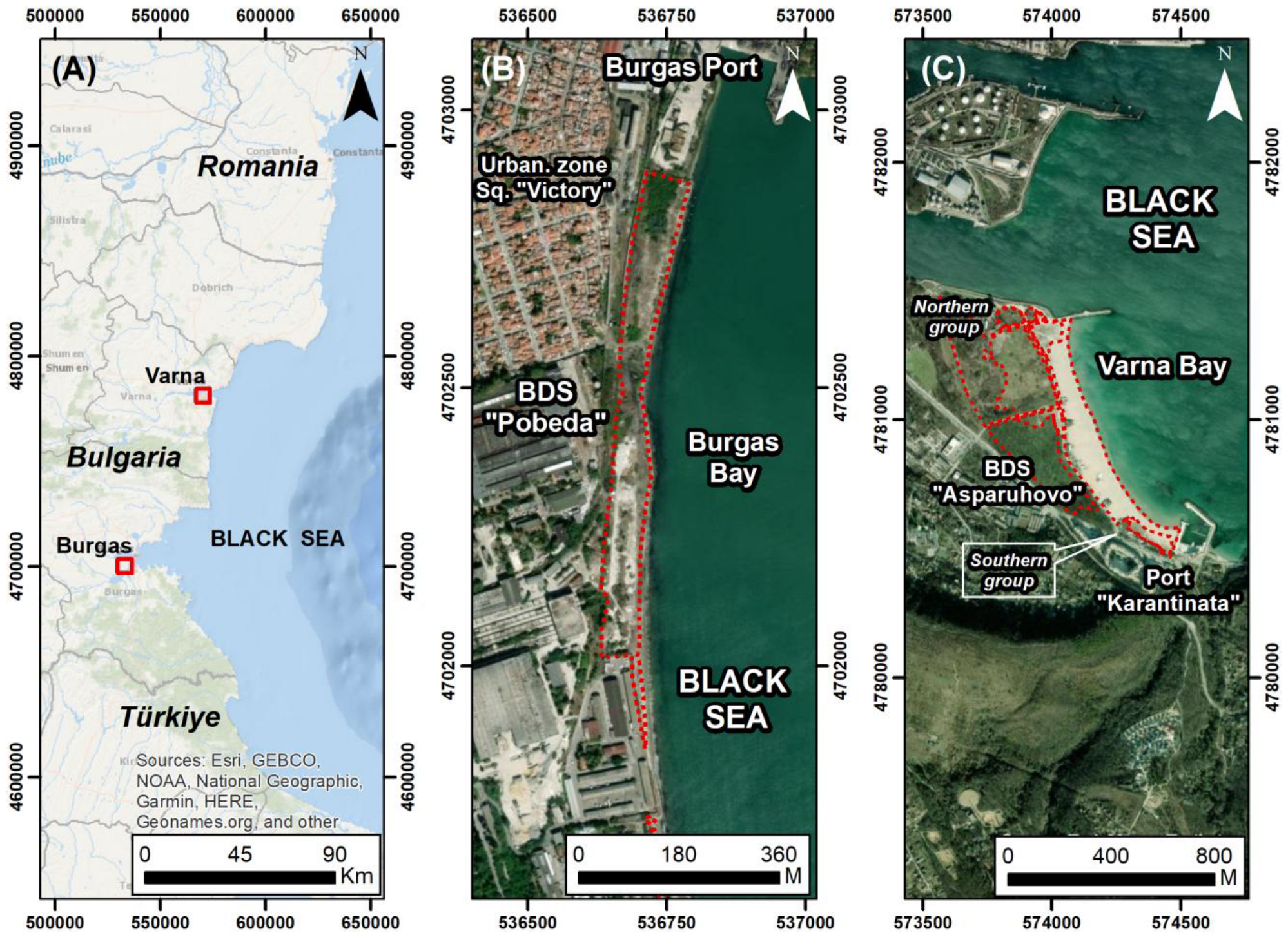
The BBSC, with a total shoreline length of approximately 517 km, is characterised by an alternation of abrasive cliff sectors and low-lying depositional coasts, where sandy beaches, sand barriers and coastal dune systems develop under favourable sedimentary and hydrodynamic conditions [34,71,72,73] (Figure 1A). Depositional coastal sectors are spatially limited and unevenly distributed along the coastline, forming discrete BDSs often embedded within strongly modified coastal landscapes [34,68,74].
Coastal dune systems along the BBSC are genetically linked to Holocene and modern sediment supply from the nearshore zone and active beaches, combined with aeolian transport and biogenic sediment trapping by dune vegetation [34,71,75]. These systems function as integral components of the coastal sediment budget, in which beaches serve as sediment sources and dunes act as long-term sediment sinks and natural coastal defence structures, contributing to shoreline stability and buffering against marine and aeolian processes [34,50,76,77].
Recent national-scale inventories based on high-resolution UAS mapping and systematic field verification demonstrate that coastal dune systems along the BBSC are highly fragmented, spatially isolated and frequently degraded [34]. Quantitative assessment indicates that the aggregate mapped area of coastal dune landforms amounts to 988.21 ha, of which 50.04 ha (5.06%) are affected by direct anthropogenic transformation. In comparison, 12 ha, corresponding to five BDSs, have been permanently lost during the last decades [34].
The mapped dune area is unevenly distributed among different Natura 2000 coastal dune habitat types. Embryonic shifting dunes (habitat 2110) occupy 68.30 ha (6.91%), reflecting their restricted spatial development at the beach–dune interface. Shifting dunes along the shoreline with Ammophila arenaria (white dunes, habitat 2120) cover 150.15 ha (15.19%), forming the most geomorphologically active and morphodynamically significant dune type. Fixed coastal dunes with herbaceous vegetation (grey dunes, habitat 2130) are the dominant habitat by area, occupying 546.41 ha (55.29%), largely as fragmented, partially degraded remnants. Wooded dunes (habitat 2180) account for 222.61 ha (22.53%), while humid dune slacks (habitat 2190) are extremely limited in extent, covering only 0.94 ha (0.09%) along the entire coastline [34].
Comparative analyses of historical cartographic materials and archival sources reveal substantial long-term loss of dune habitats, particularly during the second half of the 20th century and the early 21st century. In several coastal sectors, especially in urban and peri-urban environments, the reduction in dune area locally exceeds 50–70% of the estimated historical extent, primarily due to coastal urbanisation, infrastructure development, and land-use conversion [34]. This long-term trend explains the present dominance of secondary and stabilised dune forms, which account for 676.3 ha (68%) of the mapped dune area, compared to 311.9 ha (32%) represented by primary dune forms [34].
A major factor contributing to this cumulative loss is the persistent mismatch between the actual geomorphological extent of dune landforms and their representation in official cadastral and administrative registers. Numerous dune structures and dune sectors are partially recorded, misclassified or entirely absent from official datasets, which has facilitated their degradation or complete transformation through planning and construction activities. This discrepancy between physical reality and administrative recognition has played a central role in the long-term loss of dune habitats along the BBSC and represents a critical challenge for effective coastal management and conservation [34].
The present study focuses on two representative BDSs located in different sectors of the BBSC: the Pobeda BDS on the Burgas coast and the Asparuhovo BDS on the Varna coast. Both systems are characterised by strong anthropogenic pressure, pronounced spatial fragmentation and documented inconsistencies between their actual geomorphological extent and official spatial records, making them suitable case studies for assessing dune condition, anthropogenic impacts and conservation challenges in urban-adjacent coastal environments [76].

2.1.1. Pobeda Study Area (Burgas Coast)

The Pobeda BDS is located within the Burgas coastal sector and represents a remnant of a formerly more extensive barrier BDS that historically separated the coastal zone from Burgas Lake [71]. At present, the BDS covers a total area of 69,500 m2, including 56,600 m2 of dune habitats and 12,800 m2 of beach Figure 1B).
Geomorphologically, the system consists mainly of fixed and degraded dune forms developed landward of a narrow sandy beach, composed predominantly of fine- to medium-grained marine sands [71,76]. The low relief, discontinuous dune ridges and disturbed surface morphology reflect limited sediment supply and long-term anthropogenic transformation [71,76].
The Pobeda dunes are subject to intense anthropogenic pressure, including urban development, infrastructure expansion, historical sand extraction, surface levelling, informal access and accumulation of waste materials. More than 90% of the original dune area has been significantly modified or lost during the last several decades, severely disrupting sediment exchange between the beach and dune compartments [76].
Despite their reduced extent, the Pobeda dunes retain scientific and geomorphological significance as a rare remnant of barrier-type dunes within a heavily urbanised coastal environment. However, they remain insufficiently protected and inadequately represented in cadastral records, which creates conditions for continued degradation [76].

2.1.2. Asparuhovo Study Area (Varna Coast)

The Asparuhovo BDS is located in the southern part of Varna Bay (Figure 1C), adjacent to the Varna Lake outlet and the Asparuhov Bridge, within a low-lying depositional coastal environment influenced by longshore sediment transport and aeolian processes [71]. The system represents one of the largest sandy coastal complexes in the Varna region. Previous estimates suggest a dune area of approximately 96,100 m2 [76]; however, updated high-resolution mapping conducted in this study indicates substantially larger extents.
The dune complex includes foredunes and fixed dunes developed behind a wide sandy beach, exhibiting clear morphological zonation related to vegetation cover and aeolian dynamics [34,76]. In addition to active and semi-stabilised dune forms, relic dune features preserved beneath park vegetation have been documented and described in earlier geomorphological studies [78].
Anthropogenic pressure represents a major controlling factor on the present-day condition of the Asparuhovo dunes. Documented impacts include recreational trampling, illegal vehicle access, informal parking and camping, as well as mechanical disturbance associated with seasonal activities. A newly formed southern dune sector, developed over the last several years, has been identified as particularly vulnerable to disturbance from ongoing human activities [76].
Although parts of the Asparuhovo dune system belong to protected zones, inconsistencies in protection effectiveness and spatial registration have been reported, resulting in continued degradation of certain dune sectors [34,76]. The system therefore represents a key case study for assessing the condition, dynamics and conservation challenges of urban-adjacent coastal dunes along the northern BBSC.

2.2. Data Collection and Processing

2.2.1. Mapping of BDSs and Classification of Dune Habitats

Mapping and classification of BDSs were conducted in accordance with the Methodology of the Bulgarian Ministry of Environment and Water [68,79] for the identification, delineation, and differentiation of coastal sand dunes along the Black Sea Coast under the Black Sea Coast Spatial Development Act of the Republic of Bulgaria (BSCSDA) [80,81]. The methodology was applied as the primary framework, integrating geomorphological, sedimentological, vegetation-based and spatial criteria for dune recognition and habitat assignment [68,79].
The mapping workflow followed a hierarchical approach, including:
(i)
Identification of BDSs and their spatial extent;
(ii)
Differentiation of dune landforms based on morphology, dynamics and position within the beach–dune profile;
(iii)
Classification of dune habitats according to Natura 2000 habitat definitions, using diagnostic vegetation criteria and national interpretations [68,79,82].
UAS photogrammetry and UAS-based LiDAR were applied in compliance with the MOEW methodology and established best practices for coastal geomorphological mapping [56]. Recent studies further demonstrate the effectiveness of UAS-based photogrammetry and UAS-based LiDAR for the high-resolution mapping of coastal dune morphology, detection of subtle geomorphological change and assessment of anthropogenic disturbance in BDSs, particularly in urban and heavily impacted coastal environments [83,84,85]. The data acquisition strategy was designed to capture complementary seasonal conditions. Photogrammetric surveys were conducted during the summer, when vegetation development was at its peak and anthropogenic pressure was at its maximum, enabling a detailed mapping of vegetation cover, surface features, and human disturbance. In contrast, LiDAR surveys were conducted during winter, when vegetation cover is minimal and tourist activity is absent, enabling the accurate detection of bare-ground morphology and subtle microrelief features within the dune systems.

2.2.2. UAS Photogrammetry

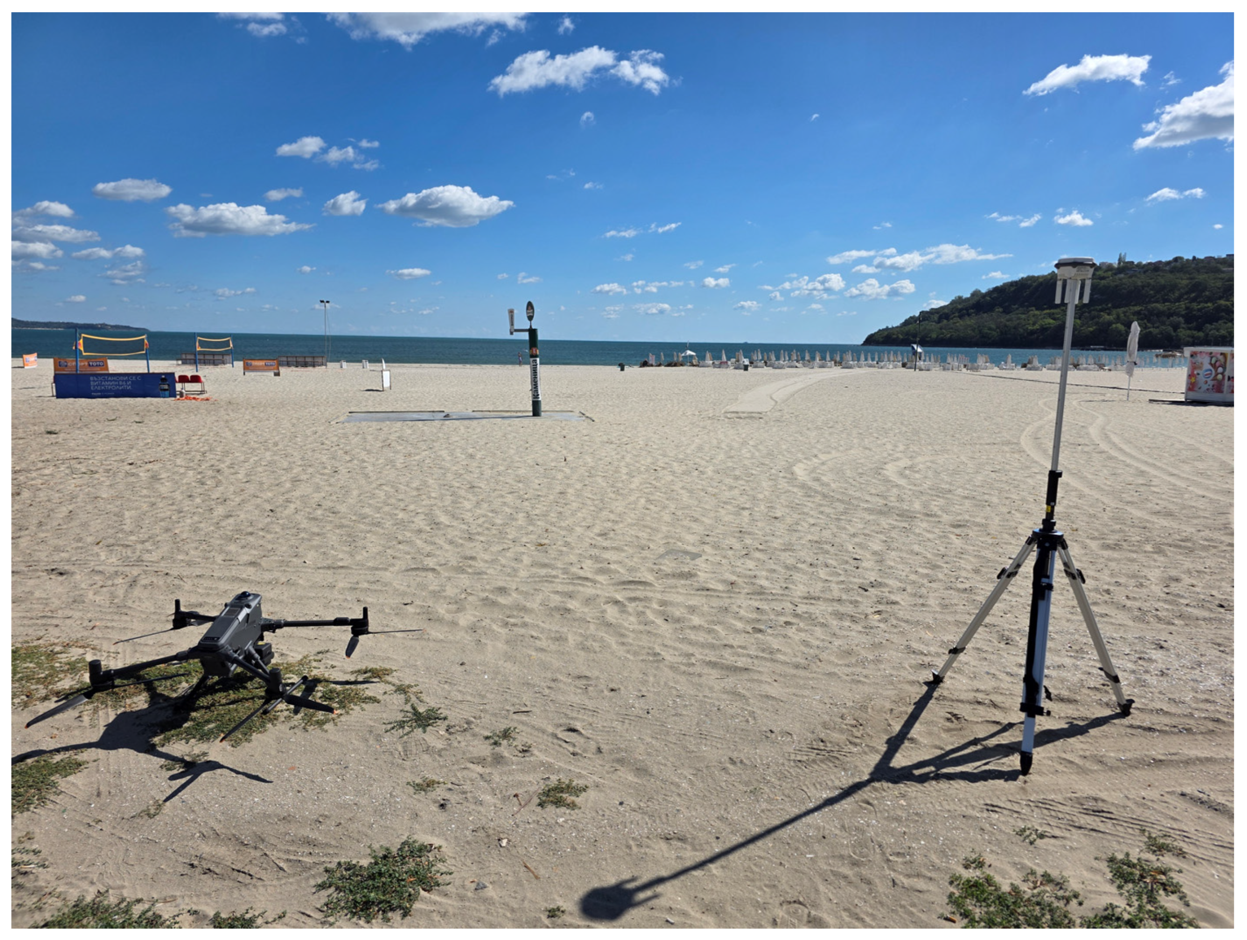
High-resolution aerial photogrammetric surveys were conducted using a DJI Matrice 400 unmanned aerial system (UAS) equipped with a Zenmuse P1 full-frame RGB camera (DJI, Shenzhen, China) (Figure 2). Data acquisition took place during the summer field campaign (5–10 September 2025) under stable meteorological conditions and low wind speeds, following established best practices for coastal and dune mapping [34,68,79].
Image acquisition was performed separately for the two study sites, reflecting differences in spatial extent and survey design. A total of 720 images were acquired at the Asparuhovo site and 861 at the Pobeda site (Table 1). Flights were conducted at an altitude of approximately 80.6 m above ground level (AGL) at Asparuhovo and 62.0 m AGL at Pobeda, resulting in ground sampling distances (GSD) of 2.09 cm/pixel and 1.62 cm/pixel, respectively.
Image acquisition followed a nadir-oriented flight plan with 80% forward overlap and 70% side overlap, ensuring a sufficient redundancy for robust Structure-from-Motion (SfM) reconstruction.
Photogrammetric processing was performed in Agisoft Metashape Professional (v.2.2.2). Bundle adjustment yielded stable internal orientation, with low reprojection errors across both datasets. The resulting dense point clouds provided a high spatial resolution suitable for detailed geomorphological analysis of low-relief beach–dune environments.
Digital Elevation Models (DEMs) were generated from the dense point clouds, with grid resolutions appropriate to the respective GSD values, enabling reliable detection of microtopographic variations on the order of decimetres. Derived Digital Orthomosaics (DOMs) and Digital Surface Models (DSMs) served as the primary spatial datasets for geomorphological interpretation, dune boundary delineation, and preliminary landform differentiation, in accordance with the MOEW methodology [34,68].

2.2.3. UAS-Based LiDAR Survey

Airborne LiDAR surveys were performed using the DJI Matrice 400 platform equipped with a Zenmuse L2 sensor during the winter field campaign (1–7 December 2025), when vegetation cover was minimal. Winter acquisition enhanced the detection of bare-ground microrelief and ridge–swale morphology, which are critical for dune geomorphological analysis [34,68].
Flights were executed at a constant altitude of 70 m AGL, providing a high point density suitable for detailed topographic modelling of beach–dune systems. LiDAR data processing was carried out in DJI Terra and included trajectory reconstruction, point cloud optimisation, ground/non-ground classification, and georeferencing in WGS 84/UTM zone 35N (Table 2).
LiDAR-derived Digital Terrain Models (DTMs) were generated through vegetation filtering and ground-point classification, providing a vegetation-free representation of dune morphology and enabling quantitative assessment of ridge continuity, crest elevation variability and anthropogenic microrelief smoothing.

2.2.4. Accuracy Assessment

Georeferencing accuracy and vertical consistency of the UAS-derived datasets were evaluated using permanent RTK-GNSS control and check points, surveyed under consistent field conditions with centimetre-level precision (Table 3).
Asparuhovo BDS. A total of 11 permanent RTK-GNSS points were established within the Asparuhovo BDS. These points were used for both georeferencing and independent accuracy assessment, with a subset designated as ground control points (GCPs) and the remainder as independent check points (CPs).
For the LiDAR-derived digital terrain model (DTM), vertical accuracy was assessed by comparing RTK-measured elevations with corresponding modelled elevations at independent check points. The results indicate a vertical RMSE of 0.006–0.007 m, with mean errors close to zero, confirming the absence of a systematic vertical bias. The low standard deviation further indicates the high internal consistency of the dataset (Table 2).
For the photogrammetric dataset, internal accuracy was evaluated using bundle adjustment statistics. The mean reprojection error is below 1 pixel, indicating stable image alignment and reliable internal geometry of the SfM model. External validation using independent checkpoints confirms centimetre-level positional accuracy (Table 3).
Pobeda BDS. A total of four permanent RTK-GNSS points were established within the Pobeda BDS and used for georeferencing and accuracy assessment. Due to the system’s smaller spatial extent, the number of control points is lower, but their distribution provides adequate spatial coverage.
Vertical accuracy of the LiDAR-derived DTM was evaluated using RTK-measured elevations at check points. The results indicate a vertical RMSE in the range of 0.006–0.010 m. Mean error values remain close to zero, indicating no systematic vertical bias. At the same time, the observed standard deviation is slightly higher than in the Asparuhovo dataset, likely due to increased surface heterogeneity (Table 2).
For the photogrammetric dataset, internal accuracy assessment based on bundle adjustment yielded reprojection errors comparable to those of the Asparuhovo system, indicating stable image alignment. External validation confirms centimetre-level positional consistency, supporting the reliability of the reconstructed surface (Table 3).
The combination of high LiDAR point density (up to 84 points/m2), low vertical error and stable photogrammetric alignment demonstrates that both datasets provide sufficient accuracy for detailed geomorphological analysis. The achieved accuracy enables the detection of microtopographic variations below 0.20 m, critical for resolving small-scale dune features and assessing geomorphological degradation.

2.2.5. Sediment Sampling and Analyses

Sediment sampling was conducted on the beach and within representative dune sectors, following the MOEW methodology, focusing on surface and shallow subsurface sediments relevant to aeolian transport and dune formation processes [34,68,79].
Laboratory analyses were performed at the Lithodynamics and Sedimentology Laboratory of the Coastal Zone Dynamics Department, Institute of Oceanology—Bulgarian Academy of Sciences. Grain-size distribution (following the Wentworth scale) was determined using a Mastersizer 3000+ laser diffraction particle size analyser (Malvern Panalytical, Malvern, UK), complemented, where necessary, by dry sieving for the coarser fractions. The results were processed using standard statistical procedures to derive grain-size distribution, sorting, and median diameter. Grain-size parameters were used as supporting evidence for dune origin, sediment continuity between beach and dunes, and compatibility with dune habitat definitions [34,68].

2.2.6. Dune Habitat Classification

Dune habitat classification was performed in accordance with the MOEW methodology [79] and the national interpretation of Natura 2000 coastal dune habitats, as defined under Annex I of the Habitats Directive and the Biological Diversity Act (BDA) [68,81,82,86].
Habitat classification requires a hybrid approach that combines supervised manual object-based image classification with field-verified data. This classification must adhere to the definitions provided in the Interpretation Manual of European Union Habitats [86] and Annex I of the BDA [82]. Dune habitat types are to be discriminated using a combination of spectral texture, vegetation structure and species composition, ensuring compliance with EU and national standards for habitat mapping and reporting.
Habitat identification was based on the presence of diagnostic plant species and vegetation assemblages, combined with dune morphology, sediment characteristics and spatial position within the BDS [68,81,82,86].

2.2.7. Anthropogenic Impact Assessment

An anthropogenic impact assessment was conducted to evaluate the types, intensities, and spatial manifestations of human-induced pressures affecting the integrity, functionality, and conservation status of the studied BDSs. The assessment focused on identifying direct and indirect disturbances to dune morphology, vegetation cover and sediment dynamics, with particular emphasis on impacts that alter the natural beach–dune sediment system and compromise dune habitat integrity.
The assessment framework was based on a typology of anthropogenic impacts on coastal dune systems (Table 4), which groups pressures according to their dominant mechanisms (e.g., access-related disturbance, vehicle-induced impacts, construction-related impacts, mechanical reshaping, anthropogenically induced erosion and pollution). For each impact group, the assessment targeted its dominant physical expression, such as vegetation disturbance and surface destabilisation (access-related impacts), sediment compaction and dune truncation (vehicle-induced impacts), permanent loss of dune morphology (construction and land-use conversion), or enhanced deflation and sediment loss (erosion-related impacts).
Severity of anthropogenic impacts was assessed individually for each dune system using a semi-quantitative scale (L—Low, M—Moderate, S—Severe), taking into account:
(i)
The spatial extent of the impact;
(ii)
The degree of geomorphological and ecological alteration;
(iii)
The effects on the functional integrity of the dune system, including sediment continuity between beach and dunes.
Macrolitter assessment on BDSs. Macrolitter abundance and spatial distribution were assessed as key indicators of anthropogenic pressure using a combined UAS-based mapping and visual census approach applied along predefined transects spanning both beach and dune areas. Transects were systematically distributed to ensure representative spatial coverage of the beach–dune systems, including the beach, foredune, and inland dune sectors. Each transect followed a shore-normal orientation, extending from the shoreline to the landward boundary of the dune system, allowing consistent comparison between beach and dune compartments. Although macrolitter has been addressed in several dedicated, campaign-based studies along the BBSC, its inclusion in the present assessment aimed to evaluate the persistence and spatial coupling of waste accumulation with dune morphology and access patterns, rather than single-event pollution levels [70,87,88,89,90].
Macrolitter data were interpreted using established quantitative and semi-quantitative indices, including the Clean Coast Index (CCI) [87], the Plastic Abundance Index (PAI) [91], and the Clean Dune Index (CDI) [87], specifically developed for dune environments. These indices were used to support comparative evaluation of pollution intensity, material composition and environmental relevance of macrolitter accumulation across different sectors of the BDSs [87,90,91].
Visual census surveys were conducted during four field campaigns spanning the four seasons (spring, summer, autumn, and winter) to assess whether macrolitter accumulation represents a persistent anthropogenic pressure or a predominantly seasonal phenomenon. This multi-seasonal approach allowed discrimination between short-term, episodic litter inputs and stable macrolitter deposits that exert long-term ecological and geomorphological effects on dune surfaces.
Macrolitter abundance was quantified as the number of items per 100 m (items/100 m), in accordance with standardised metrics used in recent coastal and dune macrolitter studies [70,87,88,89,90]. Litter items were recorded by type, material and spatial position (beach, foredune, fixed dune, interdune depression), allowing separate evaluation of pollution intensity in beach and dune environments. To account for spatial and temporal variability, macrolitter abundance values were aggregated across transects and seasonal campaigns and expressed as mean values with associated variability (standard deviation).
Macrolitter distribution patterns were further interpreted in relation to other anthropogenic impact types identified in Table 4, particularly access-related disturbance and recreational pressure, as waste accumulation frequently coincides spatially with trampling corridors, informal paths and mechanically disturbed dune surfaces.

3. Results

The results are presented through a comparative analysis of two urbanised BDSs along the BBSC that differ markedly in spatial extent, geomorphological integrity and degree of anthropogenic transformation. Quantitative mapping and high-resolution topographic analysis reveal strong contrasts between a small, highly degraded relict dune system (Pobeda, Burgas coast) and a large, morphologically heterogeneous beach–dune complex (Asparuhovo, Varna coast) that retains both stabilised and actively developing dune sectors. These contrasts provide a basis for evaluating how differences in system size, sedimentary functioning and human pressure are reflected in dune morphology, habitat distribution and vegetation structure.

3.1. Pobeda BDS (Burgas Coast)

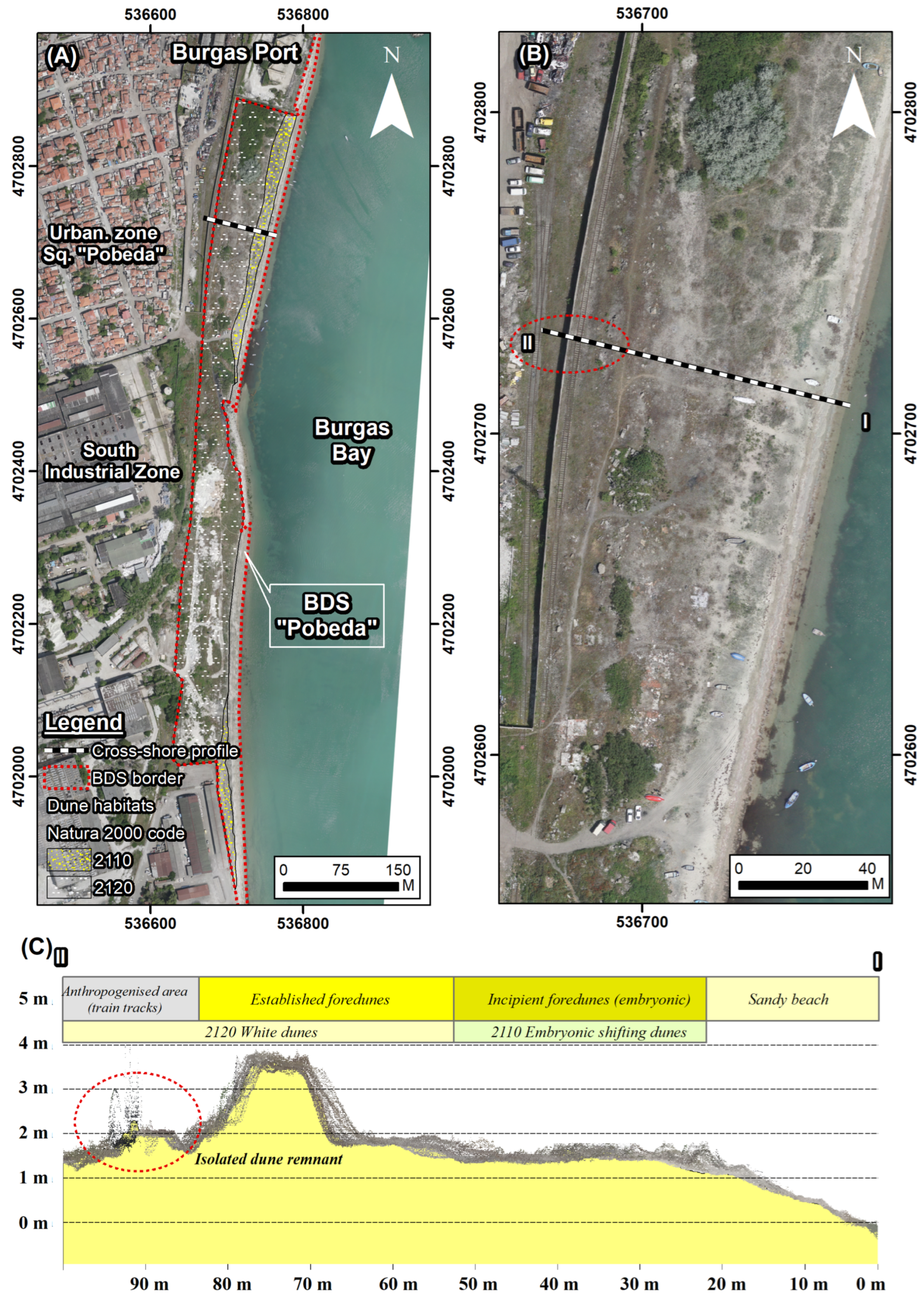
Geomorphological settings and sand dune landforms. The Pobeda BDS is a small, highly degraded urban dune remnant occupying approximately 69,500 m2. Of this area, about 56,600 m2 corresponds to mapped dune habitats (types 2110 and 2120), while the remaining 12,800 m2 represents the sandy beach sector. Despite its limited spatial extent, the system provides a clear example of advanced geomorphological degradation under long-term urban and industrial pressure. The loss of foredune continuity characterises the dune morphology, resulting in reduced relief and severely impaired aeolian sediment transport and sedimentary functioning (Figure 3).
Quantitative analysis of the UAS LiDAR-derived digital terrain model (DTM) provides additional constraints on the current geomorphological state of the system. The Pobeda dune complex is characterised by a mean elevation of 3.42 m, with a maximum elevation of 3.8 m and a minimum elevation of 1.21 m, resulting in an elevation range of approximately 2.6 m. Despite this relatively small vertical range, the preserved dune morphology is highly irregular and spatially fragmented, reflecting the coexistence of remnant dune ridges and anthropogenically modified surfaces.
Cross-shore LiDAR profile analysis (Figure 3C) shows a maximum elevation of 3.65 m and a total vertical range of approximately 3.8 m along the transect, with the profile extending from slightly below mean sea level (~−0.17 m) to the upper dune surface. However, the net elevation difference between the start and end of the profile is only ~1.5 m, indicating that the observed relief is dominated by localised elevation variability rather than a coherent foredune ridge.
Despite the moderate mean slope (~17.7°), the profile shows high cumulative ascent (5.7 m) and descent (4.2 m) over a distance of ~100 m, indicating a strongly undulating and irregular surface with frequent elevation changes. This morphology contrasts with the smooth and continuous cross-shore gradient typical of functional foredune systems. Local slope values exceeding 40° further indicate the presence of artificial scarps or heavily modified terrain, which are inconsistent with natural dune morphodynamics.
The dune system is located within a highly urbanised sector of the Burgas coast and represents a strongly transformed remnant of a former barrier-type beach–dune complex. Interpretation of the high-resolution DOM and UAS-derived DSM indicates that degraded and fragmented foredune remnants dominate the system, developed landward of the present-day beach (Figure 3).
A continuous foredune ridge is absent. Instead, the system consists of isolated elevation peaks and truncated dune segments, lacking lateral continuity along the shoreline. In natural systems, the foredune ridge functions as the primary sediment reservoir and morphological boundary between beach and dune environments; however, in Pobeda, this function is effectively lost. Preserved dune forms occur as low-amplitude but highly irregular and discontinuous dune remnants, rather than as a coherent ridge system (Figure 3).
The landward (rear) part of the dune system has been strongly modified by the construction of a railway line associated with the adjacent port infrastructure. This intervention has truncated the western dune slope, forming artificial scarps and locally removing the original dune morphology.
Despite extensive anthropogenic modification, portions of the western slope still preserve segments of the original dune morphology, expressed as relatively gentle, continuous gradients. The coexistence of preserved slope segments and artificially steepened scarps further contributes to the high terrain heterogeneity observed in the DTM and cross-shore profile.
Slope analysis derived from the DTM further highlights the system’s altered geomorphology. Mean slope values reach 17.7°, with a median slope of 13.7° and a maximum slope exceeding 87°, indicating the presence of steep, locally over-steepened surfaces. The high standard deviation of slope (13.51°) reflects strong terrain heterogeneity, associated with abrupt transitions between flattened surfaces, artificial scarps and residual dune features (Table 5).
The total preserved dune area is estimated at approximately 56,600 m2, forming a narrow, elongated belt parallel to the present shoreline. Relative elevation differences within the dune area generally do not exceed 1.0–1.5 m, reflecting a severely reduced foredune relief compared to functional systems. Distinct dune crests, slip faces and lee-side accumulation zones are not developed.
Foredune surfaces are extensively modified, with flattened and truncated morphologies affecting approximately 70–80% of the preserved dune area, as evidenced by the absence of ridge–swale morphology and the dominance of planar surfaces in the DSM. Mechanically levelled terrain and access corridors dissect the dune zone, fragmenting foredune remnants into isolated patches and disrupting cross-shore aeolian sediment transport.
The combination of high slope variability and low effective relief within individual dune fragments suggests that aeolian sediment transport pathways are no longer continuous, but instead operate as short, disconnected transport cells. This severely limits sediment exchange between the beach and dune environments and prevents the development of self-sustaining dune morphodynamics.
In its present state, the Pobeda system represents a relic, anthropogenically constrained foredune system, in which the original foredune ridge has been reduced to fragmented, nonfunctional remnants and replaced by a highly irregular, topographically discontinuous surface.
Beach and dune sediments. Sedimentological analysis of the Pobeda beach–dune system indicates a dominance of medium sand fractions with minor variability in grain-size distribution. The median grain size (D50) ranges from 260 to 364 μm (1.46–1.94 φ), reflecting a relatively homogeneous sandy depositional environment with limited contribution from coarse fractions.
Unlike the Asparuhovo system, coarse sand fractions are largely absent, and sediments are consistently dominated by medium sand (often exceeding 85–95%). This reflects a more selective sediment supply and transport regime, where finer fractions prevail. Sorting values (1.44–2.11 φ) indicate well to moderately sorted sediments, suggesting variable hydrodynamic and aeolian conditions across the system.
Minor occurrences of gravel fractions (up to ~1%) and shell fragments are locally present, particularly in samples such as Pobeda_02 and Pobeda_07, indicating occasional input of biogenic material and slightly more heterogeneous sediment sources. However, these components remain subordinate and do not significantly alter the overall sedimentological character.
The relatively narrow grain-size range and the dominance of medium sand suggest reduced energy variability and a more uniform depositional environment than in the Asparuhovo system. The limited presence of coarser fractions and the prevalence of moderately sorted sediments indicate a sediment supply that is likely constrained and more strongly influenced by local conditions rather than continuous high-energy reworking.
Overall, the sediment characteristics suggest a less dynamic but more compositionally uniform beach–dune system, where aeolian transport operates under relatively stable conditions but may be sediment-limited. These sediment characteristics are consistent with the observed geomorphological degradation, indicating disrupted sediment supply, reduced aeolian connectivity, and limited capacity for foredune regeneration. In contrast to the Asparuhovo system, where sediment exchange remains partially functional, the Pobeda system exhibits a more constrained and spatially limited sediment regime.
Dune habitats and vegetation. Despite the advanced anthropogenic modification of the Pobeda BDS, embryonic and white dunes remain present, as defined under both the Bulgarian Black Sea Coast Development Act [81] and the NATURA 2000 habitat classification. According to the Habitats Directive framework and the BDA [82], these correspond to habitat types 2110 “Embryonic shifting dunes” and 2120 “Shifting dunes along the shoreline with Ammophila arenaria” (Figure 3). The spatial distribution and structure of dune habitats are consistent with the observed geomorphological degradation. The absence of well-developed foredune ridges and the fragmentation of dune morphology are directly reflected in the discontinuous distribution of embryonic and white dunes.
Embryonic dunes occur as narrow, spatially discontinuous patches along the upper beach and the immediate landward margin of the shoreline. These features exhibit limited vertical development and are frequently intersected by trampling corridors and compacted surfaces. They are represented by microcoenoses, with participation of Salsola ruthenica, Polygonum maritimum, Suaeda altissima, Suaeda maritima, Cakile maritima subsp. euxina, Lactuca tatarica, and Xanthium italicum.
White dunes are present as fragmented and partially stabilised dune bodies, lacking continuous ridge morphology and exhibiting reduced spatial extent. The phytocoenoses are dominated by Leymus racemosus subsp. sabulosus and its accompanying Elymus farctus, Euphorbia seguierana, Linaria genistifolia subsp. genistifolia, Cynanchum acutum, Chondrilla juncea, and Atriplex spp.
Together, embryonic and white dunes occupy less than 40% of the preserved dune surface. Their spatial distribution is strongly constrained by anthropogenic features, including informal access paths, mechanically levelled terrain and adjacent urban infrastructure. Interdune depressions and humid dune slack habitats are absent. In various locations, there are monodominant groups of invasive tree species such as Elaeagnus spp., Ailanthus glandulosa, and Amorpha fruticosa.
Vegetation cover within the Pobeda dune system is uneven and structurally simplified. Areas with continuous psammophyte vegetation, naturally structured, are limited to more difficult-to-access sectors and represent approximately 30–40% of the dune surface. The areas occupied by invasive tree species are quite substantial. Trampling corridors and compacted surfaces form a dense network across the dune area, with an estimated path density exceeding 6–8 linear metres per 100 m2 in the most affected sectors.
The preserved psammophyte plant communities are dominated by stabilising species tolerant of disturbance, indicating surface fixation without the restoration of natural dune dynamics or effective sediment capture by vegetation. Localised vegetation fragmentation has resulted in exposed sand patches and reduced regeneration potential in frequently disturbed areas under sustained anthropogenic pressure.
In the Pobeda BDS, the relationship between vegetation structure and dune morphology reflects advanced geomorphological degradation. Fragmented and simplified vegetation patterns correspond to highly irregular and discontinuous dune morphology, characterised by truncated foredune remnants and flattened surfaces. Areas with sparse or disturbed vegetation coincide with zones of intense anthropogenic modification, where aeolian sediment transport is disrupted and sediment connectivity is reduced. Conversely, isolated patches of more developed psammophytic vegetation are associated with locally preserved dune remnants, indicating limited sediment trapping and partial morphological stability. Overall, the weak and fragmented vegetation cover reflects a system where geomorphological structure and ecological functioning are both significantly impaired.
Anthropogenic pressure and macrolitter pollution. Anthropogenic pressure within the Pobeda BDS is intense and spatially pervasive, affecting more than 80% of the preserved dune area either directly or through edge effects. Access-related disturbance is expressed by a dense network of informal footpaths and trampling corridors, with trampling affecting over 60% of the dune surface. Vehicle-induced disturbance is spatially localised but functionally significant, resulting in surface compaction and local truncation of dune forms (Table 6).
Construction-related impacts and land-use conversion have permanently transformed large parts of the former dune system. These impacts are irreversible and have confined the remaining dune remnants within a narrow corridor between urban and industrial infrastructure.
Macrolitter contamination represents a major component of anthropogenic pressure. Multi-seasonal surveys conducted during four field campaigns (spring, summer, autumn and winter) indicate persistent waste accumulation. In the beach sector, the average macrolitter abundance reaches approximately 1112 ± 180 items/100 m, corresponding to the “Dirty” class according to the CCI. In contrast, the dune environment exhibits higher macrolitter accumulation, reaching approximately 1450 ± 250 items/100 m, consistently exceeding the CDI threshold for extremely dirty dunes.
Plastic debris dominates the litter composition, accounting for approximately 70–80% of recorded items. The calculated PAI corresponds to the High Abundance class. The observed variability reflects both spatial heterogeneity along transects and seasonal fluctuations between survey campaigns. Partially buried litter items are widespread within the dune surface, indicating repeated accumulation and aeolian reworking and confirming that pollution represents a chronic and persistent pressure rather than episodic contamination.

3.2. Asparuhovo BDS (Varna Coast)

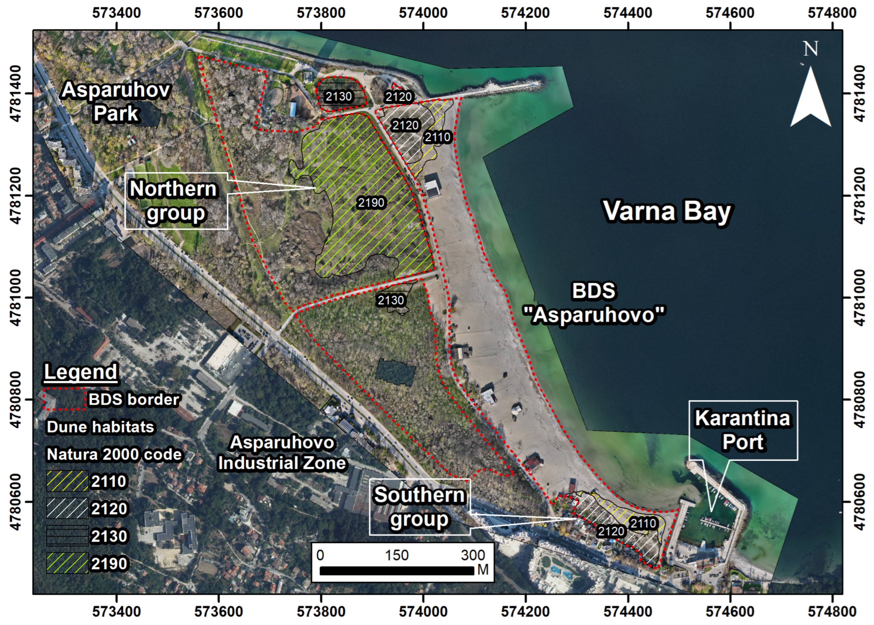
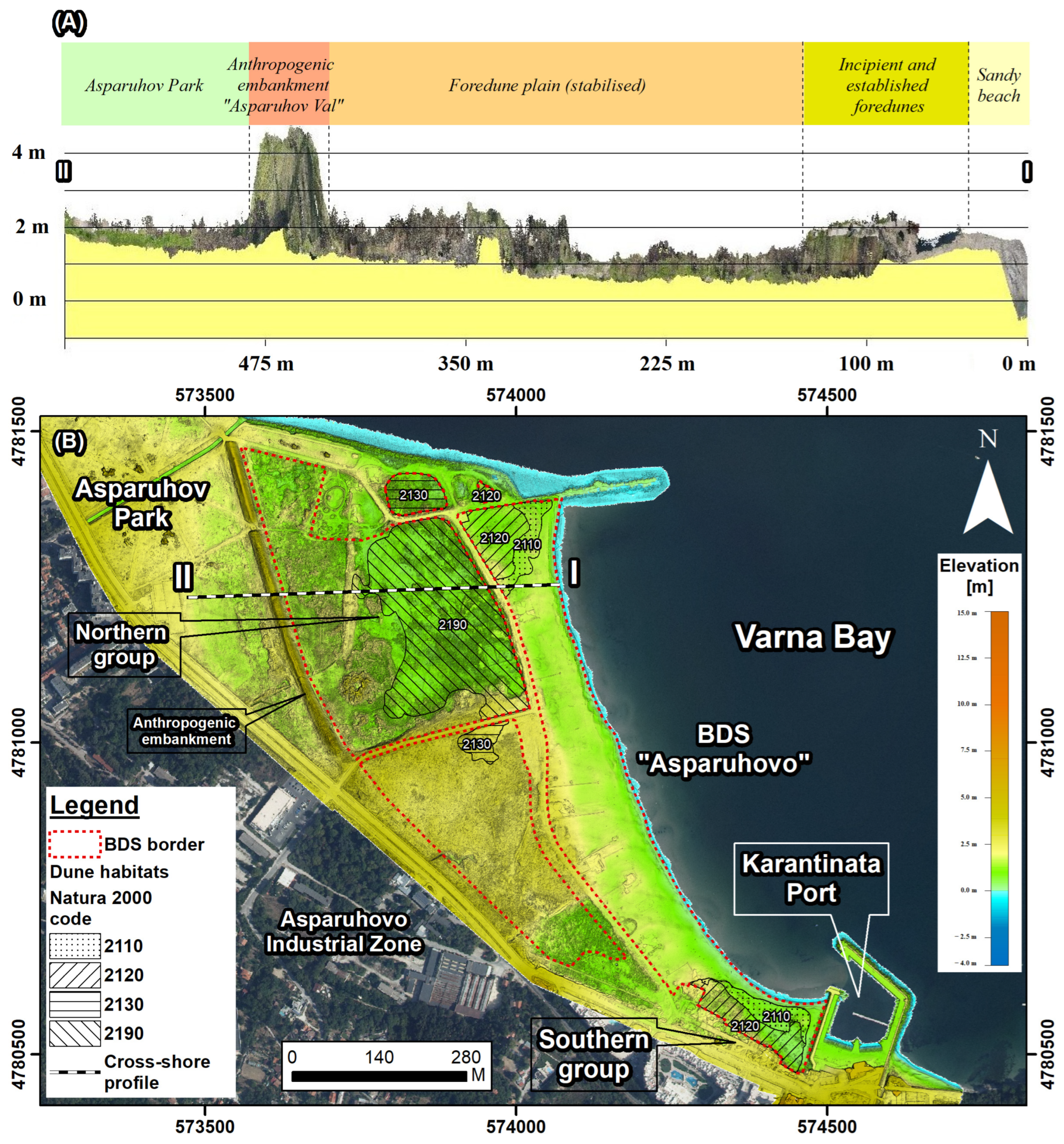
Geomorphological settings and sand dune landforms. The Asparuhovo BDS constitutes one of the largest urban beach–dune complexes along the BBSC, covering a mapped beach–dune system area of approximately 0.30 km2 (299,327 m2), including both the beach strip and the adjacent dune belt. The dune belt itself occupies approximately 191,346 m2, while the sandy beach extends over 107,981 m2. Owing to its large spatial extent and heterogeneous geomorphological structure, the system exhibits pronounced internal differentiation in dune morphology, sediment dynamics and developmental stage, allowing clear distinction between relatively stabilised and recently formed dune sectors. The system is located along the western sector of Varna Bay and represents a spatially extensive urban beach–dune complex developed between the active shoreline and the urban hinterland. Interpretation of the high-resolution DOM and elevation data indicates that the system is characterised by a foredune-dominated geomorphological setting, with clear spatial differentiation between the Northern and Southern dune groups (Figure 4 and Figure 5).
Beach and dune sediments. Sedimentological analysis of the Asparuhovo beach–dune system indicates a clear dominance of sandy fractions with negligible gravel and mud content, confirming a well-developed sandy depositional environment. Grain-size distributions are unimodal and predominantly composed of coarse to medium sand. The median grain size (D50) ranges between 382 and 612 μm (0.71–1.39 φ), reflecting a transition from coarser beach sediments to relatively finer dune materials (Table 7).
Coarse sand fractions dominate in the beach sector (e.g., D50 up to 612 μm), where sediments are better sorted and exhibit higher proportions of coarse and medium sand (up to ~58% coarse sand). This reflects continuous hydrodynamic reworking and selective removal of finer fractions by wave action. In contrast, dune sediments are characterised by a higher proportion of medium and fine sand fractions (up to ~75% medium sand), with slightly lower median grain sizes (typically 380–470 μm), indicating selective aeolian transport and deposition of finer particles landward (Table 7).
Sorting values (1.47–1.80 φ) indicate moderately well-sorted sediments across both beach and dune environments, suggesting relatively stable sediment supply and consistent transport processes. The observed granulometric continuity between the beach and dune compartments confirms the functional coupling of the beach–dune system, in which the beach serves as the primary sediment source for aeolian transport.
Minor occurrences of silt and mud fractions (<1%) are limited and do not significantly influence sediment dynamics. The absence of gravel fractions further supports the dominance of low- to moderate-energy depositional conditions typical of sandy coastal systems. Overall, the sediment characteristics indicate an active but partially constrained sediment exchange system, where aeolian processes remain effective despite increasing anthropogenic pressure in the area.
These sediment properties indicate a relatively high-energy depositional environment and favour efficient aeolian transport under appropriate wind conditions, supporting the development and maintenance of foredune morphology.
The Northern dune group of the Asparuhovo system is characterised by a sequence of embryonic dunes, foredunes and an extensive foredune plain. Embryonic dunes occur as low, discontinuous aeolian accumulations along the upper beach, reflecting early-stage sand trapping under vegetation control. Aerial photographs confirm that these forms lack continuous crest development and are spatially fragmented, consistent with incipient foredune initiation rather than fully developed dune ridges. Landward of these forms, elongated, shore-parallel foredunes constitute the dominant dune landforms, with locally preserved crest morphology. Aerial photographs show that these foredune ridges form a coherent, though locally modified, morphological barrier between the beach and the landward dune zone.
Further landward, dune morphology transitions into a low-relief foredune plain, expressed as broad, planar to gently undulating aeolian sand surfaces. This foredune plain represents flattened and stabilised foredune sands, formed through progressive reduction in dune relief and lateral coalescence of foredune elements. Aerial photographs reveal the absence of individualised dune ridges, slipfaces, or oriented aeolian forms within this zone, instead showing a laterally continuous, low-relief sand surface with subdued microtopography. The morphology reflects a stabilised, currently low-activity state of the dune system, with limited contemporary aeolian reworking and reduced aeolian mobility. The foredune plain is further characterised by dense vegetation cover and anthropogenic confinement, which reinforce surface stabilisation.
Relative elevation differences within the northern dune group typically do not exceed ~2 m, indicating a low-relief but well-preserved dune morphology.
Cross-shore LiDAR profile analysis (Figure 4 and Figure 5) confirms the presence of a morphologically coherent foredune system. The profile shows maximum elevations of ~2.14 m and a vertical range of ~1.8 m along a ~454 m transect. Despite the very low overall gradient (~0.14°) and a net elevation difference of ~1.1 m, the profile exhibits substantial cumulative ascent (21.9 m) and descent (20.8 m), indicating a sequence of low-amplitude foredune ridges and shallow interdune depressions (Table 5).
The combination of well-sorted sediments and preserved ridge continuity indicates active, although reduced, aeolian sediment transport and effective sediment trapping by vegetation, supporting a quasi-equilibrium sedimentary regime.
Southern dune group. In contrast to the northern sector, the southern dune group is characterised by recently formed dune features, developed in response to changes in local sediment dynamics. Geomorphological evidence indicates that the dunes in the southern group formed over the last approximately 3 years, following the construction of adjacent port infrastructure, which altered nearshore sediment transport pathways and local sand availability.
These dunes are predominantly expressed as incipient and embryonic foredune forms, with limited vertical development and a discontinuous spatial distribution. Their morphology reflects rapid aeolian accumulation driven by enhanced local sand supply rather than long-term dune evolution. Crest development is weak, and dune forms remain narrow and spatially constrained, indicating an early developmental stage of foredune formation.
Sediments in the southern sector exhibit slightly poorer sorting (σ ≈ 0.6–0.8) and more variable D50 values (≈0.23–0.28 mm), reflecting rapid and spatially uneven sediment deposition without sufficient time for aeolian sorting and morphological organisation.
Cross-shore profile analysis indicates a similarly low-relief morphology, with maximum elevations of ~2.15 m and a vertical range of ~1.8 m along a ~443 m transect. The profile is characterised by a very low overall gradient (~0.12°) and limited net elevation difference (~0.9 m), but significant cumulative ascent (21.1 m) and descent (20.1 m), reflecting undulating microtopography.
The combination of moderate sorting and discontinuous morphology indicates an active but non-equilibrated sedimentary regime, characterised by localised deposition and incomplete development of foredune structures.
Dune habitats and vegetation. The distribution of dune habitats within the Asparuhovo BDS reflects the geomorphological structure and developmental state of the dune forms, with clear spatial differentiation between the Northern and Southern dune groups, with the psammophyte vegetation being directly dependent on the implementation of technical activities for the maintenance of a recreational beach or active beach strip.
Northern dune group. Within the northern dune group, dune habitats display a well-developed spatial structure corresponding to the presence of mature foredunes and an associated foredune plain. Along the upper beach, embryonic shifting dunes (2110) occur as narrow, discontinuous belts, where pioneer plant species colonise newly deposited sand and initiate aeolian sediment trapping, periodic vegetation removal severely compromises the structural development and ecological functioning of psammophytic vegetation.
Landward of this zone, shifting dunes along the shoreline (2120) form the dominant habitat type, occupying the foredune ridges and adjacent slopes. These habitats are arranged in elongated, shore-parallel belts and exhibit relatively continuous spatial distribution, reflecting the preserved foredune morphology and sustained, though currently reduced, aeolian activity. The plant communities include Centaurea arenaria, Corispermum nitidum, Eryngium maritimum, Lactuca tatarica, Leymus racemosus subsp. sabulosus, Medicago marina, Silene euxina and Stachys maritima, etc.
Further inland, dune habitats transition into fixed coastal dunes (2130), developed on stabilised sandy substrates associated with the foredune plain. These areas are characterised by well-established vegetation cover and limited surface mobility, consistent with the geomorphological expression of a mature and stabilised foredune plain. Typical species recorded in the plant communities are Anchusa velenovskyi, Lepidotrichum uechtritzianum, Merendera sobolifera, etc.
Within the central part of the northern dune group, humid dune slacks (2190) are developed in low-lying interdune depressions, reflecting local groundwater influence and providing additional habitat diversity within the dune system. Species recorded in the plant communities are: Apera spica-venti, Carex colchica, Juncus articulatus, Inula britanica, Holoschoenus vulgaris, Phragmites australis, Oenothera biennis, Juncus littoralis, etc.
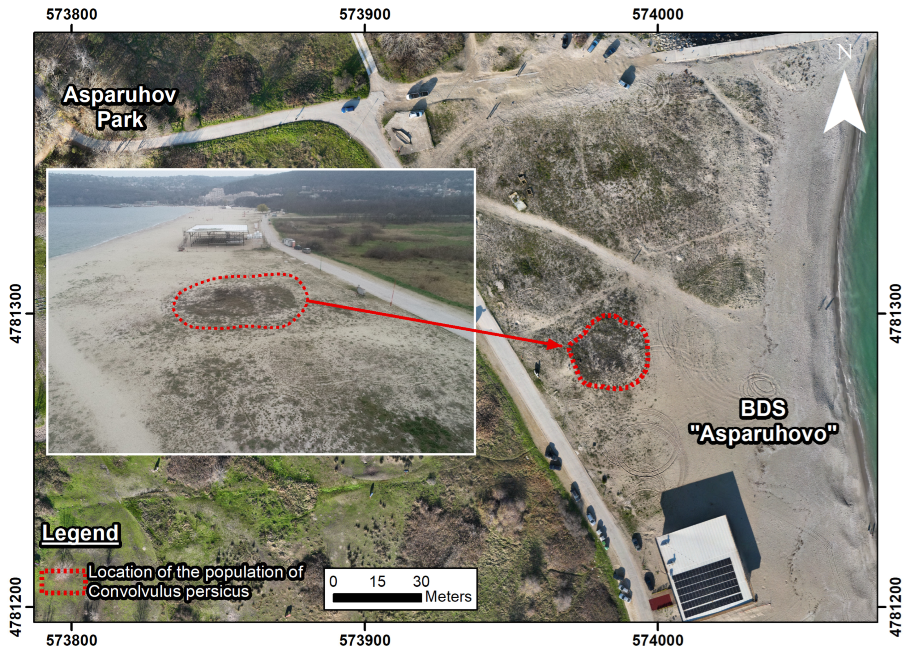
A particularly important ecological feature within the northern dune group is the presence of a localised population of the rare psammophilous species Convolvulus persicus (Figure 6). The species is confined to a limited area within the foredune plain, associated with semi-stabilised sandy substrates, indicating the persistence of suitable microhabitat conditions despite ongoing anthropogenic pressure.
The spatial restriction of this population reflects the fragmented nature of the dune system and highlights the dependence of psammophilous vegetation on the preservation of morphologically coherent dune surfaces. The proximity of the population to disturbed zones and informal access routes further increases its vulnerability to trampling, surface modification and habitat degradation.
The occurrence of Convolvulus persicus, a species of high conservation importance included in the Red Data Book of the Republic of Bulgaria and protected under national legislation of BDA, significantly enhances the ecological value of the Asparuhovo BDS and underlines the need for targeted conservation measures and improved spatial recognition within cadastral and management frameworks [92,93,94].
Southern dune group. In the southern dune group, dune habitats reflect a recent stage of development associated with newly formed dune features. Embryonic shifting dunes (2110) dominate this sector and are distributed across recently accumulated sandy surfaces, where vegetation establishment and aeolian sand trapping are in an early phase.
Small and spatially restricted areas of shifting dunes (2120) occur locally, corresponding to incipient foredune development along parts of the shoreline. These habitats remain discontinuous and exhibit limited spatial coherence, consistent with the short timescale of dune formation and ongoing geomorphological adjustment.
Overall, the Asparuhovo BDS supports a geomorphology-controlled habitat mosaic, characterised by mature and stabilised dune habitats within the northern dune group and early-stage, developing dune habitats within the southern dune group. The observed habitat distribution mirrors differences in dune maturity, sediment availability, and stabilisation processes across the system, as well as anthropogenically induced dynamics in the psammophytic coenoses.
Vegetation cover within the Asparuhovo BDS shows a clear gradient of dune development and disturbance intensity, closely linked to the system’s geomorphological characteristics. Distinct differences in vegetation structure, composition and successional stage are evident between the northern and southern dune groups, corresponding to contrasting levels of dune maturity, aeolian activity and anthropogenic influence.
Northern dune group. In the northern dune group, vegetation is continuous and structurally differentiated between the foredune ridges and the landward foredune plain, forming a well-developed and stabilising plant cover. Foredune ridges are characterised by dense stands of tall, perennial rhizomatous dune grasses, forming compact tufts that effectively trap aeolian sand and promote vertical dune accretion.
Landward of the foredune ridges, within the foredune plain, vegetation structure changes markedly, forming a dense, low- to medium-height grass cover characteristic of stabilised dune surfaces. This zone supports a relatively homogeneous vegetation layer composed primarily of perennial grasses, typical of fixed coastal dunes, contributing to a more complex vegetation mosaic. The composition and structure of this vegetation assemblage indicate long-term surface stabilisation, reduced aeolian mobility and a mature successional stage of dune development associated with the foredune plain.
Overall, vegetation patterns in the northern dune group reflect a stabilised and low-activity foredune system, where vegetation plays a dominant role in limiting sand mobility and maintaining dune morphology over extended timescales.
Southern dune group. In contrast, vegetation in the southern dune group is sparse, discontinuous and spatially fragmented, reflecting the recent initiation and early developmental stage of the dune forms. Vegetation is composed primarily of pioneer annual and perennial psammophytic species adapted to frequent sand burial, surface instability and mechanical disturbance. Field photographs document the presence of characteristic embryonic dune species, such as Cakile maritima and Salsola ruthenica, and Lactuca tatarica, accompanied by scattered tufts of Leymus racemosus subsp. sabulosus.
These species occur mainly as isolated individuals or small clusters separated by extensive areas of exposed sand, indicating limited surface stabilisation and active aeolian accumulation. Vegetation cover remains low and poorly developed, particularly along informal access routes and disturbed areas, where trampling and surface compaction further disrupt plant continuity and dune morphology. The observed vegetation structure is characteristic of an early successional stage associated with embryonic and incipient foredune environments, reflecting the short timescale of dune formation and the ongoing influence of anthropogenic disturbance.
The spatial relationship between vegetation structure and dune morphology in the Asparuhovo BDS reflects the degree of geomorphological stability and sediment dynamics. In the northern dune group, relatively well-developed foredune ridges and the foredune plain are associated with continuous psammophytic vegetation cover, which enhances sediment trapping and contributes to surface stabilisation. In contrast, the southern dune group exhibits fragmented and sparse vegetation, corresponding to recently formed, low-relief embryonic dunes with limited morphological organisation. This indicates that vegetation establishment follows initial sediment accumulation but has not yet reached a stage sufficient to stabilise dune morphology. Overall, vegetation distribution closely mirrors geomorphological structure, with higher vegetation continuity associated with morphologically stable dune sectors and sparse or discontinuous vegetation corresponding to actively evolving or recently formed dune features.
Anthropogenic pressure and macrolitter pollution. Anthropogenic pressure within the Asparuhovo BDS is moderate overall, but spatially heterogeneous. Access-related disturbance affects approximately 30–40% of the dune surface, primarily concentrated along designated and informal pathways. Vehicle-induced disturbance is rare and spatially localised, while construction-related impacts are mainly confined to the margins of the dune system. Mechanical reshaping is observed locally, particularly in the Southern group, but does not dominate the overall dune morphology.
Macrolitter pollution exhibits a clear contrast between the beach and dune compartments and was assessed using indicators consistent with the CCI, CDI and PAI (Table 8). In the beach sector, macrolitter abundance reaches approximately 850 ± 140 items/100 m, corresponding to the “Moderately dirty” class according to the CCI, reflecting regular cleaning activities that limit litter accumulation despite intensive recreational use. In contrast, the dune environment shows higher macrolitter accumulation, reaching approximately 1120 ± 210 items/100 m, corresponding to the “Dirty” class based on the CDI.
The dune environment is classified as Dirty, with macrolitter accumulation exceeding that of the beach and showing limited seasonal variability. The absence of systematic cleaning within the dune zone results in the progressive accumulation of debris, which is efficiently trapped by vegetation and dune microrelief. The observed variability reflects both spatial heterogeneity along transects and seasonal fluctuations between survey campaigns.
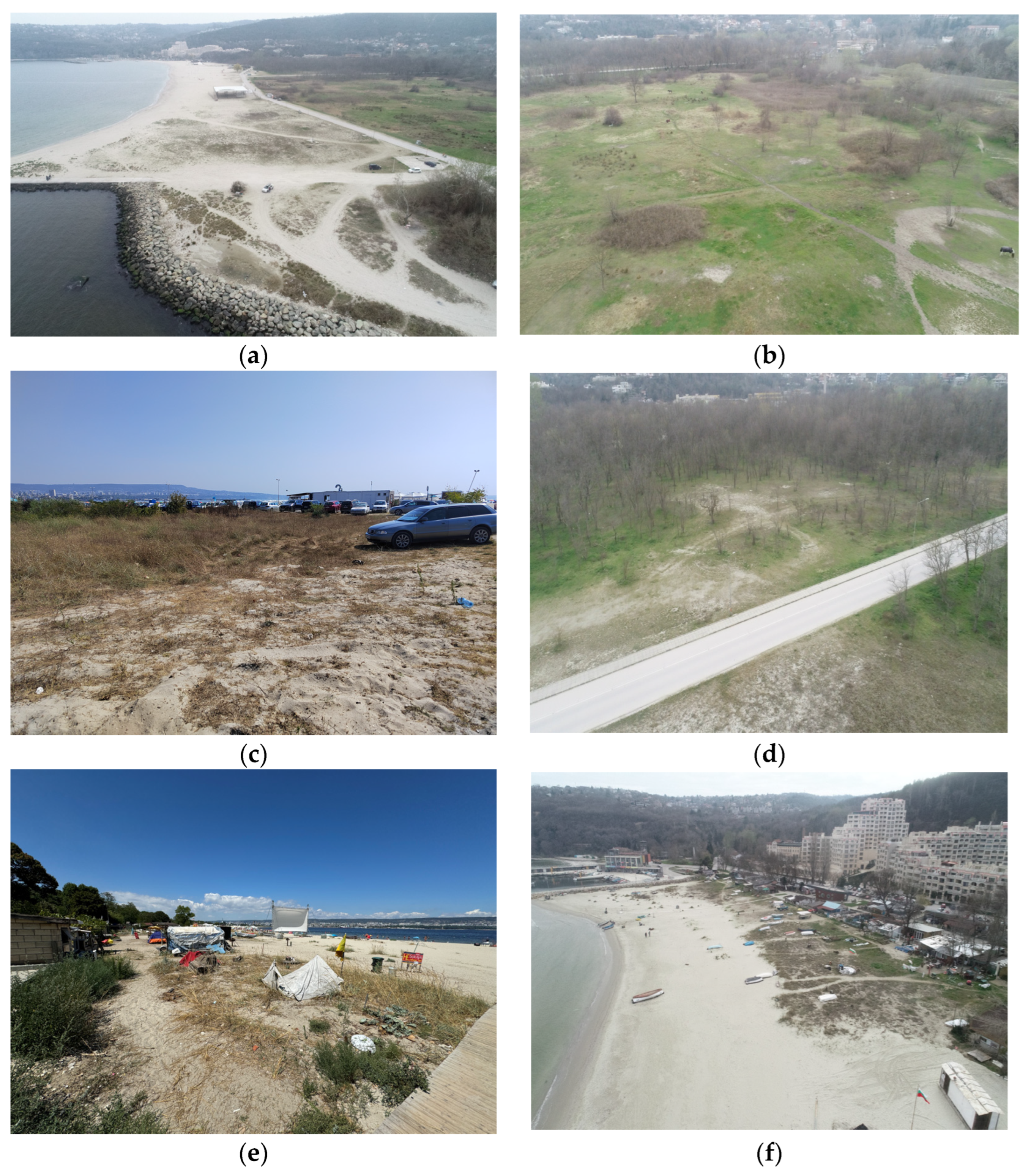
Plastic waste constitutes the dominant litter fraction within the dunes, accounting for the majority of recorded items. The calculated PAI values for the dune sector correspond to the “High Abundance” class, indicating widespread plastic contamination. Typical plastic items include packaging fragments, disposable food and beverage containers, bottle caps, and small plastic debris, which are frequently observed partially buried in the sand surface.
This pattern indicates repeated deposition and aeolian reworking, confirming that macrolitter pollution represents a chronic anthropogenic pressure on the dune habitats (Figure 7).

4. Discussion

This study provides a high-resolution geomorphological and ecological assessment of two urbanised beach–dune systems along the Bulgarian Black Sea coast, demonstrating how anthropogenic pressure modifies dune morphology, habitat structure and system functioning. The results contribute to the growing body of research on human-impacted coastal dunes by integrating UAS-derived terrain data with habitat mapping and field observations, allowing a process-based interpretation of dune condition in urban environments.

4.1. Anthropogenic Control on Dune Morphology and System Functioning

Coastal dunes are dynamic systems maintained by interactions between sediment supply, wind regime and vegetation feedbacks [2,4,5,10]. In urban environments, however, these natural controls are increasingly overridden by persistent anthropogenic pressure, which acts as a dominant driver of geomorphological change [9,20,21].
The Pobeda system represents an advanced stage of anthropogenic degradation, characterised by the near absence of a continuous foredune ridge and the dominance of flattened surfaces, indicating a transition towards a relict dune morphology with limited sediment storage capacity. Such conditions reduce the system’s ability to recover after storm events and constrain aeolian transport pathways. In contrast, Asparuhovo retains partial geomorphological functionality, as evidenced by a foredune plain and incipient dune ridges, suggesting that even under significant human pressure, dune systems may preserve elements of their natural morphodynamics when sediment supply and spatial continuity are not entirely disrupted.
The observed differences between the two systems highlight a gradient of degradation, consistent with studies showing that urbanisation leads to fragmentation, reduced resilience and altered sediment dynamics in coastal dunes [9,95]. This gradient approach provides a useful framework for interpreting dune conditions beyond binary classifications of “intact” versus “degraded” systems.

4.2. Disturbance Processes and Vegetation–Geomorphology Interactions

Vegetation plays a critical role in dune development by trapping sediment and stabilising the surface, thereby facilitating dune growth and morphological differentiation [3,12]. The results show that in Pobeda, vegetation cover is highly fragmented and closely associated with disturbed microtopography, reflecting strong anthropogenic influence. Trampling and surface disturbance lead to vegetation loss, which in turn enhances sediment mobility and erosion.
These findings are consistent with experimental and observational studies demonstrating that trampling reduces plant cover, disrupts dune-building processes and promotes surface instability [27,35,37,96]. In Pobeda, the high spatial density of access paths indicates that disturbance is not localised but system-wide, resulting in cumulative degradation effects.
In Asparuhovo, vegetation patterns are more heterogeneous and correspond more closely to geomorphological units, particularly in the northern sector. This suggests that, even when disturbance is spatially limited, vegetation–geomorphology feedbacks can still operate, supporting dune formation and partial recovery.

4.3. Habitat Fragmentation and Ecological Implications

The spatial distribution of dune habitats reflects the degree of geomorphological integrity. In Pobeda, habitats corresponding to embryonic and white dunes are highly fragmented and restricted in extent, indicating limited accommodation space and disrupted succession. In contrast, Asparuhovo exhibits a more continuous habitat mosaic, particularly in the northern sector, where geomorphological conditions allow for more stable habitat development.
Such patterns are consistent with studies linking habitat fragmentation in coastal dunes to land-use change and urban expansion [23,97]. From a conservation perspective, this suggests that geomorphological condition can serve as a proxy for habitat quality and ecosystem functionality.

4.4. Macrolitter Accumulation and Its Geomorphological Implications

Macrolitter distribution reveals additional dimensions of anthropogenic impact. The high concentrations observed in Pobeda, particularly in dune areas, confirm that dunes act as accumulation zones due to vegetation trapping and the complexity of the microrelief. Plastic debris dominates the litter composition, consistent with regional assessments of marine pollution [88,89,91].
Beyond its ecological effects, macrolitter contributes to geomorphological disturbance by altering surface conditions, damaging vegetation and facilitating informal access pathways. Vegetation can also act as a trap for litter, reinforcing accumulation patterns [98]. These interactions illustrate the coupling between pollution and geomorphological processes in urban dune systems.

4.5. Monitoring Potential and Management Implications

The integration of UAS photogrammetry and LiDAR data proved effective for detecting fine-scale geomorphological features and disturbance patterns. High-resolution terrain models enable detailed mapping of dune morphology, access paths, and microtopography, supporting more precise assessments of dune condition. Similar approaches have been successfully applied in coastal monitoring and habitat mapping [45,58,63,69].
From a management perspective, the results indicate that even heavily urbanised dune systems retain geomorphological and ecological value. Targeted interventions, such as controlled access, restrictions on mechanical disturbance, and vegetation restoration, may enhance resilience and support partial recovery [99,100]. The identification of spatially concentrated disturbance zones provides a practical basis for prioritising such measures.

4.6. Limitations and Future Research

Several limitations should be considered when interpreting the results.
First, although the UAS-derived datasets provide high spatial resolution, the detection of microtopographic features remains influenced by surface roughness, vegetation cover and data processing uncertainties. Similar limitations have been reported in image-based surface reconstruction studies [69,85].
Second, the temporal mismatch between LiDAR and photogrammetric data acquisition may introduce minor inconsistencies related to seasonal variability in vegetation and surface conditions. While this does not significantly affect the overall geomorphological interpretation, it may influence fine-scale comparisons.
Third, the analysis represents a snapshot in time and does not capture temporal dynamics such as storm-driven erosion, seasonal variability or long-term trends. Coastal dune systems are inherently dynamic, and their evolution is strongly influenced by episodic events and long-term environmental change [40].
Future research should therefore focus on multi-temporal monitoring, the integration of hydrodynamic data, and the quantitative assessment of sediment budgets. Expanding the analysis to a larger number of sites would also allow for more robust generalisation of the observed degradation gradients and improve the understanding of urban dune system resilience.

5. Conclusions

This study provides a detailed geomorphological and ecological assessment of two urbanised beach–dune systems along the Bulgarian Black Sea coast, demonstrating the extent to which anthropogenic pressure influences dune morphology, habitat structure and system functioning. The results show that the investigated systems represent different stages along a gradient of anthropogenic impact. The Pobeda system is characterised by advanced geomorphological degradation, expressed through the loss of a continuous foredune ridge, extensive surface flattening and high levels of disturbance. In contrast, the Asparuhovo system retains partial geomorphological functionality, with preserved foredune features and more structured vegetation patterns, despite ongoing human pressure.
The study highlights that vegetation–geomorphology interactions remain a key control on dune development, but are highly sensitive to disturbance. Where trampling and surface modification are spatially extensive, vegetation cover becomes fragmented, reducing sediment retention and increasing surface instability. Conversely, where disturbance is more spatially constrained, these feedback mechanisms can still operate, supporting partial system resilience.
Macrolitter accumulation, particularly within dune environments, is identified as an additional factor contributing to system degradation. The results indicate that dunes act as effective sinks for debris, with vegetation and microtopography enhancing litter retention and reinforcing disturbance patterns.
The application of UAS photogrammetry and LiDAR demonstrates strong potential for high-resolution monitoring of dune systems, enabling detailed mapping of geomorphological features, disturbance patterns, and habitat distribution. These methods provide a robust basis for supporting spatially targeted management and conservation strategies. However, the findings should be interpreted within the limitations of a single-period assessment and potential uncertainties related to data resolution and temporal variability. Further research based on multi-temporal datasets and expanded spatial coverage is required to constrain better the dynamics and long-term evolution of urban dune systems.
Overall, the study contributes to the understanding of how urbanisation affects coastal dune systems and provides a methodological framework for their assessment. The results support the need for targeted management interventions to reduce anthropogenic pressure and enhance the resilience of these vulnerable coastal environments.

Author Contributions

Conceptualisation, B.P.; methodology, B.P., R.B. and C.G.; software, B.P.; validation, B.P., M.V. and T.L.; formal analysis, B.P., C.G. and M.V.; Field survey, B.P., R.B., C.G., M.V., T.L., D.D., L.R. (Lyubomir Rasovski), N.D. and L.R. (Liya Radoslavova); resources, B.P.; data curation, B.P. and M.V.; writing—original draft preparation, B.P.; writing—review and editing, R.B., C.G., M.V. and A.B.; visualisation, B.P.; supervision, C.G. and J.P.; project administration, B.P.; funding acquisition, B.P. All authors have read and agreed to the published version of the manuscript.

Funding

This research was funded by Bulgarian National Science Fund grant number: KΠ-06-H84-5/16.12.2024.

Institutional Review Board Statement

Not applicable.

Informed Consent Statement

Not applicable.

Data Availability Statement

Data are contained within the article.

Acknowledgments

The study was developed under the project “Mapping and Spatiotemporal Analysis of Beach-Dune Systems on the Southern Bulgarian Black Sea Coast: Evolution, Anthropogenic Pressure and Ecological Risks to Dune Habitats (MapBGBeachDune)”. Grant No. KΠ-06-H84/5-16.12.2024 under Competition for financial support of basic research projects of the Bulgarian National Science Fund.

Conflicts of Interest

The authors declare no conflict of interest.

Abbreviations

The following abbreviations are used in this manuscript:
BBSCBulgarian Black Sea Coast
BDABiological Diversity Act
BDSBeach–Dune System
BSCSDABlack Sea Coast Spatial Development Act of the Republic of Bulgaria
DSMDigital Surface Model
DTMDigital Terrain Model
LiDARLight Detection and Ranging
MOEWMinistry of Environment and Water (Republic of Bulgaria)
UASUnmanned Aerial System

References

  1. Pye, K. Coastal Dunes. Prog. Phys. Geogr. Earth Environ. 1983, 7, 531–557. [Google Scholar] [CrossRef]
  2. Psuty, N.P. The Coastal Foredune: A Morphological Basis for Regional Coastal Dune Development. In Ecological Studies; Springer: Berlin/Heidelberg, Germany, 2008; pp. 11–27. [Google Scholar]
  3. Hesp, P.A. Ecological Processes and Plant Adaptations on Coastal Dunes. J. Arid Environ. 1991, 21, 165–191. [Google Scholar] [CrossRef]
  4. Hesp, P. Dune Coasts. In Treatise on Estuarine and Coastal Science; Elsevier: Amsterdam, The Netherlands, 2011; pp. 193–221. [Google Scholar]
  5. Hesp, P.A. Coastal Dunes: Types, Initiation, Morphology, Evolution, and Relationships to Surfzone-Beach Systems and Climate. In Treatise on Estuarine and Coastal Science, 2nd ed.; Elsevier: Amsterdam, The Netherlands, 2024; pp. 866–903. [Google Scholar]
  6. Delgado-Fernandez, I. A Review of the Application of the Fetch Effect to Modelling Sand Supply to Coastal Foredunes. Aeolian Res. 2010, 2, 61–70. [Google Scholar] [CrossRef]
  7. Martínez, M.L.; Hesp, P.A.; Gallego-Fernández, J.B. Coastal Dunes: Human Impact and Need for Restoration. In Springer Series on Environmental Management; Springer: Berlin/Heidelberg, Germany, 2013; pp. 1–14. [Google Scholar]
  8. Hesp, P.A.; Walker, I.J. Coastal Dunes. In Treatise on Geomorphology; Elsevier: Amsterdam, The Netherlands, 2013; pp. 328–355. [Google Scholar]
  9. Nordstrom, K.F. Beaches and Dunes of Developed Coasts; Cambridge University Press: Cambridge, UK, 2000. [Google Scholar]
  10. Jackson, N.L.; Nordstrom, K.F. Aeolian Sediment Transport and Landforms in Managed Coastal Systems: A Review. Aeolian Res. 2011, 3, 181–196. [Google Scholar] [CrossRef]
  11. Ranwell, D.S. Ecology of Salt Marshes and Sand Dunes; Chapman and Hall: London, UK, 1972. [Google Scholar]
  12. Martínez, M.L.; Psuty, N.P. Coastal Dunes: Ecology and Conservation; Springer: Berlin, Germany, 2004. [Google Scholar]
  13. Barbier, E.B.; Hacker, S.D.; Kennedy, C.; Koch, E.W.; Stier, A.C.; Silliman, B.R. The value of estuarine and coastal ecosystem services. Ecol. Monogr. 2011, 81, 169–193. [Google Scholar] [CrossRef]
  14. Doody, J.P. Sand Dune Conservation, Management and Restoration; Springer: Dordrecht, The Netherlands, 2013. [Google Scholar]
  15. Drius, M.; Jones, L.; Marzialetti, F.; de Francesco, M.C.; Stanisci, A.; Carranza, M.L. Not Just a Sandy Beach. The Multi-Service Value of Mediterranean Coastal Dunes. Sci. Total Environ. 2019, 668, 1139–1155. [Google Scholar] [CrossRef]
  16. McLachlan, A.; Brown, A.C. The Ecology of Sandy Shores; Academic Press: Burlington, MA, USA, 2006. [Google Scholar]
  17. Petrosillo, I.; Zurlini, G.; Corlianò, M.E.; Zaccarelli, N.; Dadamo, M. Tourist Perception of Recreational Environment and Management in a Marine Protected Area. Landsc. Urban Plan. 2007, 79, 29–37. [Google Scholar] [CrossRef]
  18. Haller, I.; Stybel, N.; Schumacher, S.; Mossbauer, M. Will Beaches Be Enough? Future Changes for Coastal Tourism at the German Baltic Sea. J. Coast. Res. 2011, 61, 70–80. [Google Scholar] [CrossRef]
  19. Drius, M.; Bongiorni, L.; Depellegrin, D.; Menegon, S.; Pugnetti, A.; Stifter, S. Tackling Challenges for Mediterranean Sustainable Coastal Tourism: An Ecosystem Service Perspective. Sci. Total Environ. 2019, 652, 1302–1317. [Google Scholar] [CrossRef] [PubMed]
  20. Defeo, O.; McLachlan, A.; Schoeman, D.S.; Schlacher, T.A.; Dugan, J.; Jones, A.; Lastra, M.; Scapini, F. Threats to Sandy Beach Ecosystems: A Review. Estuar. Coast. Shelf Sci. 2009, 81, 1–12. [Google Scholar] [CrossRef]
  21. Defeo, O.; McLachlan, A.; Armitage, D.; Elliott, M.; Pittman, J. Sandy Beach Social–Ecological Systems at Risk: Regime Shifts, Collapses, and Governance Challenges. Front. Ecol. Environ. 2021, 19, 564–573. [Google Scholar] [CrossRef]
  22. Van Der Maarel, E. Some Remarks on the Functions of European Coastal Ecosystems. Phytocoenologia 2003, 33, 187–202. [Google Scholar] [CrossRef]
  23. Malavasi, M.; Santoro, R.; Cutini, M.; Acosta, A.T.R.; Carranza, M.L. What Has Happened to Coastal Dunes in the Last Half Century? A Multitemporal Coastal Landscape Analysis in Central Italy. Landsc. Urban Plan. 2013, 119, 54–63. [Google Scholar] [CrossRef]
  24. Alodos, C.L.; Pueyo, Y.; Barrantes, O.; Escós, J.; Giner, L.; Robles, A.B. Variations in Landscape Patterns and Vegetation Cover between 1957 and 1994 in a Semiarid Mediterranean Ecosystem. Landsc. Ecol. 2004, 19, 543–559. [Google Scholar] [CrossRef]
  25. Hesp, P.A.; Martínez, M.L. Disturbance Processes and Dynamics in Coastal Dunes. In Plant Disturbance Ecology; Elsevier: Amsterdam, The Netherlands, 2007; pp. 215–247. [Google Scholar]
  26. Acosta, A.; Carranza, M.L.; Di Martino, L.; Frattaroli, A.; Izzi, C.F.; Stanisci, A. Patterns of native and alien plant species occurrence on coastal dunes in Central Italy. In Plant Invasions: Human Perception, Ecological Impacts and Management; Tokarska-Guzik, B., Brock, J.H., Brundu, G., Child, L., Daehler, C.C., Pišek, P., Eds.; Backhuys: Leiden, The Netherlands, 2008; pp. 235–248. [Google Scholar]
  27. Farris, E.; Pisanu, S.; Ceccherelli, G.; Filigheddu, R. Human Trampling Effects on Mediterranean Coastal Dune Plants. Plant Biosyst. Int. J. Deal. All Asp. Plant Biol. 2013, 147, 1043–1051. [Google Scholar] [CrossRef]
  28. Giulio, S.; Acosta, A.T.R.; Carboni, M.; Campos, J.A.; Chytrý, M.; Loidi, J.; Pergl, J.; Pyšek, P.; Isermann, M.; Janssen, J.A.M.; et al. Alien Flora across European Coastal Dunes. Appl. Veg. Sci. 2020, 23, 317–327. [Google Scholar] [CrossRef]
  29. Giulio, S.; Cao Pinna, L.; Carboni, M.; Marzialetti, F.; Acosta, A.T.R. Invasion Success on European Coastal Dunes. Plant Sociol. 2021, 58, 29–39. [Google Scholar] [CrossRef]
  30. Šilc, U.; Stešević, D.; Luković, M.; Caković, D. Changes of a Sand Dune System and Vegetation between 1950 and 2015 on Velika Plaža (Montenegro, E Mediterranean). Reg. Stud. Mar. Sci. 2020, 35, 101139. [Google Scholar] [CrossRef]
  31. Cascone, S.; Sperandii, M.G.; Cao Pinna, L.; Marzialetti, F.; Carranza, M.L.; Acosta, A.T.R. Exploring Temporal Trends of Plant Invasion in Mediterranean Coastal Dunes. Sustainability 2021, 13, 13946. [Google Scholar] [CrossRef]
  32. Valcheva, M.; Sopotlieva, D.; Apostolova, I.; Tsvetkova, N. Vegetation Characteristics and Recent Successional Trends of Sand Dune Habitats at the Bulgarian Black Sea Coast. Coasts 2021, 1, 1–24. [Google Scholar] [CrossRef]
  33. Dubyna, D.V.; Iemelianova, S.M.; Dziuba, T.P. Alien Plant Invasion across Coastal Dunes of Ukraine. Biologia 2023, 78, 1401–1414. [Google Scholar] [CrossRef]
  34. Prodanov, B.; Dimitrov, L.; Kotsev, I.; Bekova, R.; Lambev, T. Spatial Distribution of Sand Dunes along the Bulgarian Black Sea Coast: Inventory, UAS Mapping and New Discoveries. Nat. Conserv. 2023, 54, 81–120. [Google Scholar] [CrossRef]
  35. Šilc, U.; Caković, D.; Küzmič, F.; Stešević, D. Trampling Impact on Vegetation of Embryonic and Stabilised Sand Dunes in Montenegro. J. Coast. Conserv. 2016, 21, 15–21. [Google Scholar] [CrossRef]
  36. Hesp, P.; Schmutz, P.; Martinez, M.L.; Driskell, L.; Orgera, R.; Renken, K.; Revelo, N.A.R.; Orocio, O.A.J. The Effect on Coastal Vegetation of Trampling on a Parabolic Dune. Aeolian Res. 2010, 2, 105–111. [Google Scholar] [CrossRef]
  37. Ciccarelli, D. Mediterranean Coastal Sand Dune Vegetation: Influence of Natural and Anthropogenic Factors. Environ. Manag. 2014, 54, 194–204. [Google Scholar] [CrossRef] [PubMed]
  38. Martínez, M.L.; Hesp, P.A.; Gallego-Fernández, J.B. Coastal Dune Restoration: Trends and Perspectives. In Springer Series on Environmental Management; Springer: Berlin/Heidelberg, Germany, 2013; pp. 323–339. [Google Scholar]
  39. Carter, R. Coastal Environments; Academic Press: Cambridge, MA, USA, 1988. [Google Scholar] [CrossRef]
  40. Vousdoukas, M.I.; Ranasinghe, R.; Mentaschi, L.; Plomaritis, T.A.; Athanasiou, P.; Luijendijk, A.; Feyen, L. Sandy Coastlines under Threat of Erosion. Nat. Clim. Change 2020, 10, 260–263. [Google Scholar] [CrossRef]
  41. Reguero, B.G.; Losada, I.J.; Méndez, F.J. A Recent Increase in Global Wave Power as a Consequence of Oceanic Warming. Nat. Commun. 2019, 10, 205. [Google Scholar] [CrossRef]
  42. Temmerman, S.; Meire, P.; Bouma, T.J.; Herman, P.M.J.; Ysebaert, T.; De Vriend, H.J. Ecosystem-Based Coastal Defence in the Face of Global Change. Nature 2013, 504, 79–83. [Google Scholar] [CrossRef]
  43. Rangel-Buitrago, N.; Giarrizzo, T.; Brabo, L.; Silva Filho, F.J.; Cooper, J.A.G.; Neal, W.J. Updating Coastal Beach Classification: A Cluster-Based Typology for Contemporary Human Use and Management. Ocean Coast. Manag. 2026, 273, 108064. [Google Scholar] [CrossRef]
  44. Brunier, G.; Fleury, J.; Anthony, E.J.; Gardel, A.; Dussouillez, P. Close-Range Airborne Structure-from-Motion Photogrammetry for High-Resolution Beach Morphometric Surveys: Examples from an Embayed Rotating Beach. Geomorphology 2016, 261, 76–88. [Google Scholar] [CrossRef]
  45. Casella, E.; Drechsel, J.; Winter, C.; Benninghoff, M.; Rovere, A. Accuracy of Sand Beach Topography Surveying by Drones and Photogrammetry. Geo-Mar. Lett. 2020, 40, 255–268. [Google Scholar] [CrossRef]
  46. Štroner, M.; Urban, R.; Reindl, T.; Seidl, J.; Brouček, J. Evaluation of the Georeferencing Accuracy of a Photogrammetric Model Using a Quadrocopter with Onboard GNSS RTK. Sensors 2020, 20, 2318. [Google Scholar] [CrossRef] [PubMed]
  47. Alvarez-Vanhard, E.; Houet, T.; Mony, C.; Lecoq, L.; Corpetti, T. Can UAVs Fill the Gap between in Situ Surveys and Satellites for Habitat Mapping? Remote Sens. Environ. 2020, 243, 111780. [Google Scholar] [CrossRef]
  48. Ma, D.; Tian, Z.; Zhu, C.; Wang, Y. A Comprehensive Approach to Evaluate Coastal Dune Evolution in Haiyang, China. Front. Mar. Sci. 2024, 11, 1326317. [Google Scholar] [CrossRef]
  49. Prodanov, B.; Kotsev, I.; Bekova, R.; Dimitrov, L.; Lambev, T. UAS Photogrammetry as an Effective Tool for High-Resolution Mapping of Depositional Landforms and Monitoring Geomorphic Change. Case Study: Kamchia-Shkorpilovtsi Beach, Bulgarian Black Sea Coast. In Proceedings of the SGEM International Multidisciplinary Scientific GeoConference EXPO Proceedings, Albena, Bulgaria, 16–22 August 2021; STEF92 Technology: Sofia, Bulgaria, 2021; Volume 21, pp. 623–634. [Google Scholar]
  50. Prodanov, B. Long-Term Dynamics of the Harmani-Sozopol Beach-Dune System, Bulgarian Black Sea Coast. In Proceedings of the SGEM International Multidisciplinary Scientific GeoConference EXPO Proceedings, Albena, Bulgaria, 3–8 July 2023; STEF92 Technology: Sofia, Bulgaria, 2023; Volume 23, pp. 65–76. [Google Scholar]
  51. Dimitrova, N.; Ivanov, M.; Naylyan Salieva, N.; Rasovski, L. Shoreline Dynamics and Evolution of Sandy Beaches along the Burgas Coast during the Period of 1980s to 2025. In Proceedings of the SGEM International Multidisciplinary Scientific GeoConference EXPO Proceedings, Albena, Bulgaria, 29 June–6 July 2025; STEF92 Technology: Sofia, Bulgaria, 2025; Volume 25, pp. 163–178. [Google Scholar]
  52. Salieva, N. UAS-Based Monitoring and Multi-Temporal Analysis of Shoreline Dynamics in the Kavatsite Beach Sector (1980s-2025), Southern Bulgarian Black Sea Coast. In Proceedings of the SGEM International Multidisciplinary Scientific GeoConference EXPO Proceedings, Albena, Bulgaria, 29 June–6 July 2025; STEF92 Technology: Sofia, Bulgaria, 2025; Volume 25, pp. 179–190. [Google Scholar]
  53. Akay, S.S.; Özcan, O.; Özcan, O. Spatiotemporal Evolution of Coastal Dune Systems in the Çukurova Delta Plain: A Multitemporal Analysis Using Historical Aerial Photographs and UAV-Based Photogrammetry. Appl. Sci. 2025, 15, 13065. [Google Scholar] [CrossRef]
  54. Woolard, J.W.; Colby, J.D. Spatial Characterization, Resolution, and Volumetric Change of Coastal Dunes Using Airborne LIDAR: Cape Hatteras, North Carolina. Geomorphology 2002, 48, 269–287. [Google Scholar] [CrossRef]
  55. Saye, S.E.; van der Wal, D.; Pye, K.; Blott, S.J. Beach–Dune Morphological Relationships and Erosion/Accretion: An Investigation at Five Sites in England and Wales Using LIDAR Data. Geomorphology 2005, 72, 128–155. [Google Scholar] [CrossRef]
  56. Casella, E.; Rovere, A.; Pedroncini, A.; Stark, C.P.; Casella, M.; Ferrari, M.; Firpo, M. Drones as Tools for Monitoring Beach Topography Changes in the Ligurian Sea (NW Mediterranean). Geo-Mar. Lett. 2016, 36, 151–163. [Google Scholar] [CrossRef]
  57. Tysiąc, P.; Ossowski, R.; Janowski, Ł.; Moskalewicz, D. Utilizing UAV and Orthophoto Data with Bathymetric LiDAR in Google Earth Engine for Coastal Cliff Degradation Assessment. Sci. Rep. 2025, 15, 704. [Google Scholar] [CrossRef]
  58. Laporte-Fauret, Q.; Marieu, V.; Castelle, B.; Michalet, R.; Bujan, S.; Rosebery, D. Low-Cost UAV for High-Resolution and Large-Scale Coastal Dune Change Monitoring Using Photogrammetry. J. Mar. Sci. Eng. 2019, 7, 63. [Google Scholar] [CrossRef]
  59. Brunier, G.; Michaud, E.; Fleury, J.; Anthony, E.J.; Morvan, S.; Gardel, A. Assessing the Relationship between Macro-Faunal Burrowing Activity and Mudflat Geomorphology from UAV-Based Structure-from-Motion Photogrammetry. Remote Sens. Environ. 2020, 241, 111717. [Google Scholar] [CrossRef]
  60. Guisado-Pintado, E.; Jackson, D.W.T.; Rogers, D. 3D Mapping Efficacy of a Drone and Terrestrial Laser Scanner over a Temperate Beach-Dune Zone. Geomorphology 2019, 328, 157–172. [Google Scholar] [CrossRef]
  61. Grohmann, C.H.; Garcia, G.P.B.; Affonso, A.A.; Albuquerque, R.W. Dune Migration and Volume Change from Airborne LiDAR, Terrestrial LiDAR and Structure from Motion-Multi View Stereo. Comput. Geosci. 2020, 143, 104569. [Google Scholar] [CrossRef]
  62. Cruz, C.; O’Connell, J.; McGuinness, K.; Martin, J.R.; Perrin, P.M.; Connolly, J. Assessing the Effectiveness of UAV Data for Accurate Coastal Dune Habitat Mapping. Eur. J. Remote Sens. 2023, 56, 2191870. [Google Scholar] [CrossRef]
  63. Bazzichetto, M.; Malavasi, M.; Acosta, A.T.R.; Carranza, M.L. How Does Dune Morphology Shape Coastal EC Habitats Occurrence? A Remote Sensing Approach Using Airborne LiDAR on the Mediterranean Coast. Ecol. Indic. 2016, 71, 618–626. [Google Scholar] [CrossRef]
  64. Le Mauff, B.; Juigner, M.; Ba, A.; Robin, M.; Launeau, P.; Fattal, P. Coastal Monitoring Solutions of the Geomorphological Response of Beach-Dune Systems Using Multi-Temporal LiDAR Datasets (Vendée Coast, France). Geomorphology 2018, 304, 121–140. [Google Scholar] [CrossRef]
  65. Liu, J.; Wu, J.; Okida, S.; Kimura, R.; Du, M.; Li, Y. Detection and Monitoring of Topography Changes at the Tottori Sand Dune Using UAV-LiDAR. Sensors 2026, 26, 302. [Google Scholar] [CrossRef] [PubMed]
  66. Martín-Gallego, P.; Delgado-Fernandez, I.; Marston, C. The Application of Satellite Remote Sensing to Coastal Dune Environments: A Systematic Review. Prog. Phys. Geogr. Earth Environ. 2025, 50, 138–160. [Google Scholar] [CrossRef]
  67. McLaughlin, D.; Doyle, T.B.; Asbridge, E.F.; Rogers, K. A Framework for Using Coastal Monitoring Data: A Foredune Case Study. Ocean Coast. Manag. 2026, 272, 107989. [Google Scholar] [CrossRef]
  68. Prodanov, B.; Gussev, C.; Sopotlieva, D.; Valcheva, M.; Bekova, R.; Baltakova, A.; Tzonev, R.; Popov, J. A Standard Procedure for Dune Mapping along the Bulgarian Black Sea Coast: An Integrated Approach Combining UAS Photogrammetry, Geomorphological and Phytocoenological Surveys. Front. Mar. Sci. 2025, 12, 1579724. [Google Scholar] [CrossRef]
  69. Eltner, A.; Kaiser, A.; Castillo, C.; Rock, G.; Neugirg, F.; Abellán, A. Image-Based Surface Reconstruction in Geomorphometry—Merits, Limits and Developments. Earth Surf. Dyn. 2016, 4, 359–389. [Google Scholar] [CrossRef]
  70. Guidance on the Monitoring of Marine Litter in European Seas. Available online: https://op.europa.eu/publication/manifestation_identifier/PUB_KJNA31539ENN (accessed on 4 March 2026).
  71. Popov, V.L.; Mishev, K. Geomorphology of the Bulgarian Black Sea Coast and Shelf; Academic Press of the Bulgarian Academy of Sciences: Sofia, Bulgaria, 1974; 253p. (In Bulgarian) [Google Scholar]
  72. Krastev, T. Morphosculpture of the Bulgarian Black Sea Coast. In Geography of Bulgaria; Kopralev, I., Jordanova, M., Mladenov, C., Eds.; ForKom: Sofia, Bulgaria, 2002; pp. 57–59. (In Bulgarian) [Google Scholar]
  73. Peychev, V. Morphodynamic and Lithodynamic Processes in the Coastal Zone; Slavena: Varna, Bulgaria, 2004; 232p. (In Bulgarian) [Google Scholar]
  74. Kotsev, I.; Prodanov, B.; Dimitrov, L. Geomorphology of the Bulgarian Black Sea Coastal Zone. In Landscapes and Landforms of Bulgaria; World Geomorphological Landscapes Series; Springer: Cham, Switzerland, 2026; ISSN 2213-2090. [Google Scholar]
  75. Stancheva, M. Sand Dunes along the Bulgarian Black Sea Coast. Comptes Rendus L’académie Bulg. Des. Sci. 2010, 63, 1037–1048. [Google Scholar]
  76. Prodanov, B.; Bekova, R. Coastal Dunes under Threat of Destruction: Necessities Conservation and Inclusion into the Cadastral Maps and Registries of the Bulgarian Black Sea Coast. In Proceedings of the SGEM International Multidisciplinary Scientific GeoConference EXPO Proceedings; STEF92 Technology, Vienna, Austria, 27–30 November 2024; Volume 24, pp. 253–264. [Google Scholar]
  77. Prodanov, B.; Baltakova, A.; Bekova, R.; Tzonev, R.; Valcheva, M.; Lambev, T. Dune Landforms of the Strandzha Coast, Southern Bulgarian Black Sea. In Landscapes and Landforms of Bulgaria; World Geomorphological Landscapes Series; Springer: Cham, Switzerland, 2026; ISSN 2213-2090. [Google Scholar]
  78. Peychev, V.; Peev, P. Evolution of the Bulgarian Black Sea Coast After the Early Holocene; Slavena: Varna, Bulgaria, 2006; 123p. (In Bulgarian) [Google Scholar]
  79. Prodanov, B.; Valcheva, M.; Gussev, C.; Sopotlieva, D. Methodology for Mapping, Determining Boundaries and the Type of Sand Dunes, According to Art. 11, Para. 2 of Ordinance No. 1 of 16 September 2008 on the Creation and Maintenance of the Specialized Maps and Registers of the Sites Under Art. 6, Para. 4 and 5 of the Black Sea Coast Spatial Development Act of the Republic of Bulgaria; Ministry of Environment and Water (MOEW): Sofia, Bulgaria, 2024. Available online: https://www.moew.government.bg/static/media/ups/tiny/file/Nature/Protected_areas/Duni/Metodika_duni.pdf (accessed on 4 March 2026).
  80. Ordinance No. 1 of 16 September 2008 on the Creation and Maintenance of Specialised Maps and Registers of the Objects Under Article 6(4) and (5) of the Spatial Development of the Black Sea Coast Act, Promulgated in State Gazette, No. 84 of 26 September 2008, Amended and Supplemented in State Gazette, No. 64 of 18 July 2020. Available online: https://cadastre.bg/podzakonovi-normativni-aktove/naredba-%E2%84%96-1-zuchk (accessed on 4 March 2026).
  81. Black Sea Coast Spatial Development Act of the Republic of Bulgaria (BSCSDA), 2007. Available online: https://www.mrrb.bg/bg/zakon-za-ustrojstvoto-na-chernomorskoto-krajbrejie/ (accessed on 4 March 2026).
  82. Biological Diversity Act (BDA); National Assembly of the Republic of Bulgaria. State Gazette No. 77/9 August 2002; Sofia, Bulgaria, 2002. Available online: https://www.moew.government.bg/static/media/ups/tiny/filebase/Nature/Legislation/Zakoni/BiodiversityAct_Rev2023.pdf (accessed on 4 March 2026).
  83. Pérez-Hernández, E.; Ferrer-Valero, N.; Hernández-Calvento, L. Lost and Preserved Coastal Landforms after Urban Growth. The Case of Las Palmas de Gran Canaria City (Canary Islands, Spain). J. Coast. Conserv. 2020, 24, 26. [Google Scholar] [CrossRef]
  84. Laporte-Fauret, Q.; Castelle, B.; Michalet, R.; Marieu, V.; Bujan, S.; Rosebery, D. Morphological and Ecological Responses of a Managed Coastal Sand Dune to Experimental Notches. Sci. Total Environ. 2021, 782, 146813. [Google Scholar] [CrossRef]
  85. Manfreda, S.; Dvorak, P.; Mullerova, J.; Herban, S.; Vuono, P.; Arranz Justel, J.; Perks, M. Assessing the Accuracy of Digital Surface Models Derived from Optical Imagery Acquired with Unmanned Aerial Systems. Drones 2019, 3, 15. [Google Scholar] [CrossRef]
  86. European Commission, DG Environment. Interpretation Manual of European Union Habitats, Version EUR 28; European Commission, DG Environment: Brussels, Belgium, 2013; Available online: https://eunis.eea.europa.eu/references/2435 (accessed on 4 March 2026).
  87. Alkalay, R.; Pasternak, G.; Zask, A. Clean-Coast Index—A New Approach for Beach Cleanliness Assessment. Ocean Coast. Manag. 2007, 50, 352–362. [Google Scholar] [CrossRef]
  88. Bekova, R.; Prodanov, B. Assessment of Beach Macrolitter Using Unmanned Aerial Systems: A Study along the Bulgarian Black Sea Coast. Mar. Pollut. Bull. 2023, 196, 115625. [Google Scholar] [CrossRef] [PubMed]
  89. Bekova, R.; Prodanov, B. Spatiotemporal Variation in Marine Litter Distribution along the Bulgarian Black Sea Sandy Beaches: Amount, Composition, Plastic Pollution, and Cleanliness Evaluation. Front. Mar. Sci. 2024, 11, 1416134. [Google Scholar] [CrossRef]
  90. Prodanov, B.; Bekova, R. A Baseline Assessment of Anthropogenic Macrolitter on Dunes along the Bulgarian Black Sea Coast Using Visual Census and Unmanned Aerial Systems. Nat. Conserv. 2023, 54, 13–54. [Google Scholar] [CrossRef]
  91. Rangel-Buitrago, N.; Mendoza, A.V.; Mantilla-Barbosa, E.; Arroyo-Olarte, H.; Arana, V.A.; Trilleras, J.; Gracia, C.A.; Neal, W.J.; Williams, A.T. Plastic Pollution on the Colombian Central Caribbean Beaches. Mar. Pollut. Bull. 2021, 162, 111837. [Google Scholar] [CrossRef]
  92. Vladimirov, V.; Aybeke, M.; Tan, K. Reports (15–18). New floristic Records in the Balkans: 37*. Phytol. Balcan. 2018, 24, 397–461. [Google Scholar]
  93. Peev, D.; Petrova, A.; Anchev, M.; Temniskova, D.; Denchev, C.M.; Ganeva, A.; Gussev, C.; Vladimirov, V. (Eds.) Volume 1. Plants and Fungi. In Red Data Book of the Republic of Bulgaria; BAS & MOEW: Sofia, Bulgaria, 2015; 848p. [Google Scholar]
  94. Petrova, A.; Vladimirov, V. Red list of Bulgarian vascular plants. Phytol. Balcan. 2009, 15, 63–94. [Google Scholar]
  95. Martínez, M.L.; Silva, R.; Lithgow, D.; Mendoza, E.; Flores, P.; Martínez, R.; Gallego-Fernández, J.B.; Hesp, P.A. Coastal dune management and conservation. J. Environ. Manag. 2020, 260, 110135. [Google Scholar]
  96. Delgado-Fernandez, I.; O’Keeffe, N.; Davidson-Arnott, R.G.D. Natural and Human Controls on Dune Vegetation Cover and Disturbance. Sci. Total Environ. 2019, 672, 643–656. [Google Scholar] [CrossRef]
  97. Carboni, M.; Carranza, M.L.; Acosta, A. Assessing Conservation Status on Coastal Dunes: A Multiscale Approach. Landsc. Urban Plan. 2009, 91, 17–25. [Google Scholar] [CrossRef]
  98. Mancuso, M.; Genovese, G.; Porcino, N.; Natale, S.; Crisafulli, A.; Spagnuolo, D.; Catalfamo, M.; Morabito, M.; Bottari, T. Psammophytes as Traps for Beach Litter in the Strait of Messina (Mediterranean Sea). Reg. Stud. Mar. Sci. 2023, 65, 103057. [Google Scholar] [CrossRef]
  99. Pranzini, E.; Anfuso, G.; Botero, C.M.; Cabrera Hernández, J.A.; Williams, A.T. Sand dune management in developed coastal areas: A European perspective. Ocean. Coast. Manag. 2015, 118, 53–63. [Google Scholar]
  100. Nordstrom, K.F.; Jackson, N.L. Foredune Restoration in Urban Settings. In Springer Series on Environmental Management; Springer: Berlin/Heidelberg, Germany, 2013; pp. 17–31. [Google Scholar]
Figure 1. Location of the study beach–dune systems along the Bulgarian Black Sea coast: (A) Western Black Sea Region; (B) BDS “Pobeda”; (C) BDS “Asparuhovo”.
Conservation 06 00050 g001
Figure 2. Field survey equipment used at Asparuhovo beach (Varna, Bulgaria), including an unmanned aerial system (DJI Matrice 400) and a D-RTK reference station.
Conservation 06 00050 g002
Figure 3. Spatial structure of the Pobeda beach–dune system (Burgas coast, Bulgaria): (A) study area with mapped Natura 2000 dune habitats (2110 and 2120); (B) orthophoto showing the location of the cross-shore transect and anthropogenic features; (C) cross-shore profile derived from LiDAR data; the red dashed circle indicates an anthropogenically modified sector, including a railway line and adjacent disturbed terrain.
Conservation 06 00050 g003
Figure 4. Distribution of Natura 2000 dune habitats (2110, 2120, 2130 and 2190) within the Asparuhovo beach–dune system (Varna Bay, Bulgaria), including the delineated BDS boundary and its subdivision into northern and southern groups.
Conservation 06 00050 g004
Figure 5. Cross-shore geomorphological profile and distribution of dune habitats within the Asparuhovo beach–dune system (Varna Bay, Bulgaria): (A) LiDAR-derived topographic profile illustrating the transition from anthropogenically modified terrain (artificial embankment) to a stabilised foredune plain and incipient foredunes; (B) spatial distribution of Natura 2000 dune habitats (2110, 2120, 2130 and 2190) over a LiDAR-derived DEM.
Conservation 06 00050 g005
Figure 6. Location of the population of Convolvulus persicus within the Asparuhovo beach–dune system (Varna Bay, Bulgaria), with inset showing a detailed view of the identified population.
Conservation 06 00050 g006
Figure 7. Field photographs of the Asparuhovo beach–dune system (Varna coast, Bulgaria): (a) low-relief foredune and foredune plain with sparse pioneer vegetation along the upper beach; (b) stabilised foredune plain with continuous grass cover and scattered shrubs in the northern dune group; (c) mechanically disturbed dune surface affected by vehicle access and compaction; (d) foredune plain fragmented by linear infrastructure and access corridors; (e) intensive recreational pressure and informal structures within the beach–dune transition zone; (f) overall aerial view of the southern dune group, illustrating the spatial relationship between the beach, dune belt and urban hinterland.
Conservation 06 00050 g007
Table 1. Data processing and accuracy assessment of UAS-photogrammetry datasets for Asparuhovo and Pobeda beach–dune systems.
ParameterPhotogrammetry
(Asparuhovo & Pobeda)
LiDAR
(Asparuhovo & Pobeda)
UAS platformDJI Matrice 400DJI Matrice 400
SensorZenmuse P1 (RGB camera)Zenmuse L2 (LiDAR)
Survey periodSummer (September 2025)Winter (December 2025)
Survey objectiveVegetation, surface features, anthropogenic impactDune morphology, microrelief
Flight altitude (m AGL)~77.5~70
Flight speed (m/s)~10~10
Ground sampling distance (GSD)1.99 cm/pix
LiDAR point density (points/m2)80–85
Ground point density (points/m2)65–70
Scan rate (kHz)240
Pulse rate (kHz)240
Image overlap (forward/side)80%/70%
Number of images720 (Asparuhovo)/861 (Pobeda)
Processing softwareAgisoft Metashape Professional v.2.1DJI Terra (DJI, China)
Output productsDOM, DSM, dense point cloudDTM, classified point cloud
GeoreferencingRTK GNSSRTK/PPK GNSS
Control/check points11 RTK GNSS points11 RTK GNSS points
Table 2. Data processing and accuracy assessment of LiDAR datasets for Asparuhovo and Pobeda beach–dune systems.
CategoryParameterAsparuhovo BDSPobeda BDS
Positioning & acquisitionSensorDJI Zenmuse L2DJI Zenmuse L2
PlatformUAVUAV
Positioning solutionRTK/PPK (POS Fix: 100%)RTK/PPK (POS Fix: 100%)
Flight height (m)63.45–68.6868–72
Absolute accuracyRMSE X (m)0.010.01
RMSE Y (m)0.010.01
RMSE Z (m)0.010.01
Trajectory & orientationIMU attitude error (rad)0.000.00
Flight strip overlap (%)12.5712.40
Altitude difference (m)9.639.80
Point cloud characteristicsTotal density (points/m2)84.0082.00
Ground point density (points/m2)69.0067.00
Terrain modelDEM resolution (m)0.10.1
Grid size (m)0.10.1
Non-conforming grid ratio (%)7.43–9.576.80–9.10
Ground control & validationGround control points (GCPs)11 (RTK measured)4 (RTK measured)
Validation approachRTK-supported georeferencingRTK-supported georeferencing
Processing workflowSoftwareDJI Terra (v5.1.1)DJI Terra (v5.1.1)
Processing methodLiDAR point cloud optimisation, classification and DEM generationLiDAR point cloud optimisation, classification and DEM generation
Accuracy typeSystem-level (POS/IMU constrained)System-level (POS/IMU constrained)
Table 3. Photogrammetric data quality and accuracy assessment for Asparuhovo and Pobeda beach–dune systems.
CategoryParameterAsparuhovo BDSPobeda BDS
Data acquisitionSurvey periodSeptemberSeptember
Number of images720.00861.00
Flight altitude (m)80.6062.00
Ground sampling distance (cm/pix)2.091.62
Coverage area (km2)0.510.23
Image alignment & geometryAligned images708.00674.00
Tie points548.13296.76
Reprojection error (pix)0.930.68
Camera accuracyCamera location error X (m)0.240.01
Camera location error Y (m)0.840.01
Camera location error Z (m)0.490.01
Total camera error (m)1.000.01
Ground control & validationNumber of GCPs11 (RTK measured)4 (RTK measured)
GCP RMSE X (cm)0.711.00
GCP RMSE Y (cm)0.711.21
GCP RMSE Z (cm)0.230.28
Total GCP RMSE (cm)1.031.59
Checkpoints RMSE (cm) 3.18
Model characteristicsPoint cloud density (points/m2)143.00238.00
DEM resolution (cm/pix)8.376.48
Orthomosaic resolution (cm/pix)2.091.62
Processing workflowSoftwareAgisoft MetashapeAgisoft Metashape
Processing approachSfM-MVS workflowSfM-MVS workflow
Coordinate systemWGS84/UTM zone 35NWGS84/UTM zone 35N
Table 4. Typology of anthropogenic impacts on coastal dune systems.
Main Impact Type Typical Manifestations Observed/Inferred Consequences Severity *
Access-related anthropogenic disturbanceInformal footpaths and trampling corridors across foredunes and fixed dunes; dense networks of beach-access paths; paths dissecting dune ridgesVegetation destruction; surface destabilisation; fragmentation of dune habitats; loss of dune ridge continuity; initiation of deflation featuresL/M/S
Vehicle-induced disturbanceOff-road vehicle tracks on dune surfaces; compacted sand layers; parking areas located on dunes or within the backdune zoneSurface compaction; vegetation stripping; dune truncation; reduced aeolian sediment transport; enhanced erosionL/M/S
Construction-related impacts on dunesBuildings, beach facilities, roads, walkways, platforms or stairways constructed directly on dune bodies or foredunesPartial or complete removal of dune landforms; physical degradation of dune morphology; irreversible loss of dune structure; conversion to non-dune land useL/M/S
Artificial levelling, infilling and mechanical reshapingFlattened dune surfaces; mechanically smoothed relief; infilled interdune depressions; artificial sand embankments with regular geometryDune truncation or obliteration; loss of dune microrelief; disruption of natural sediment dynamics; permanent alteration of dune morphologyL/M/S
Anthropogenically induced deflation and erosionLinear blowouts initiated by access paths; deflation hollows in areas of vegetation disturbance; expanding bare sand patches in the downwind directionEnhanced aeolian erosion; progressive degradation of dune landforms; sediment loss from the beach–dune sediment systemL/M/S
Recreational disturbanceBonfire sites; locally trampled or cleared areas; repeated short-term recreational useLocal vegetation loss; surface destabilisation; local ecological degradation of dune habitatsL/M/S
Pollution by solid waste (macrolitter)Accumulation of terrestrial or marine macrolitter; clustered or linear waste deposits in backdune areas, interdune depressions or leeward dune slopes; quantified using items/100 m, CCI, PAI and CDIEcological degradation of dune habitats; mechanical damage to vegetation; secondary surface destabilisation; reduction in natural and landscape valueL/M/S
Land-use conversion of dune areasPermanent transformation of dune surfaces into parking areas, urbanised zones, recreational facilities or landscaped terrainComplete loss of dune function; disappearance of dune habitats; long-term or irreversible exclusion from the coastal sedimentary systemL/M/S
* Impact assessment: Impact severity (L/M/S) was classified using a composite assessment integrating (i) spatial extent of the affected dune area, (ii) degree of geomorphological alteration, and (iii) level of ecological impact (vegetation disturbance and habitat degradation). The spatial extent is expressed as a percentage of the total dune area within each beach–dune system. Low (L): <25% affected dune area, minor vegetation disturbance, and no significant geomorphological alteration. Moderate (M): 25–50% affected dune area, partial vegetation loss, and local geomorphological modification affecting dune continuity or microrelief. Severe (S): >50% affected dune area, extensive vegetation loss, and clear geomorphological degradation, including dune truncation, levelling or fragmentation. The classification is applied consistently across all impact types listed in the table, with severity reflecting the combined effect of the three criteria.
Table 5. Morphometric characteristics of the Asparuhovo and Pobeda beach–dune systems derived from LiDAR-based DTM analysis.
ParameterBeach–Dune SystemInterpretation/Comparison
AsparuhovoPobeda
Total area (m2)190,00069,500Asparuhovo is significantly larger
Perimeter (km)2.402.23Comparable coastal extent
Mean elevation (m)1.853.42Pobeda shows a higher mean elevation
Minimum elevation (m)0.381.21Lower base level in Asparuhovo
Maximum elevation (m)4.163.80Pobeda contains isolated high-relief features
Elevation range (m)3.782.60Asparuhovo exhibits greater vertical variability, while Pobeda is characterised by lower overall elevation range but higher local terrain heterogeneity due to anthropogenic modification
Elevation std. dev. (m)0.871.05Slightly higher heterogeneity in Pobeda
Mean slope (°)9.1017.74Pobeda is significantly steeper
Median slope (°)7.1113.67Asparuhovo shows smoother surfaces
Maximum slope (°)73.0587.67Extreme local slopes in both systems
Slope std. dev. (°)6.8613.51Pobeda is much more irregular
Lower quartile slope (°)4.007.93Gentler terrain in Asparuhovo
Upper quartile slope (°)12.4123.42Steeper dune remnants in Pobeda
Surface area (3D, km2)0.190.06Larger and smoother surface in Asparuhovo
Dominant aspectNE (56°)E (104°)Different exposure to marine forcing
Table 6. Integrated assessment of anthropogenic impacts within the Pobeda beach–dune system (Burgas coast, Bulgaria).
Impact TypeAssessment Metric/IndexValuesSeverity
Access-related disturbanceSpatial extent of tramplingMore than 60% of the dune surface affectedS
Vehicle-induced disturbancePresence of tracks and compactionLocalised but functionally significant disturbanceS
Construction-related impactsPermanently transformed areaHigh proportion of dune area affectedS
Mechanical reshapingAltered microreliefExtensive surface flattening and truncationS
Induced erosionBare sand patches/incipient blowoutsModerate spatial extent with high functional impactS
Recreational disturbanceActivity overlapHigh intensity and recurrence of human activityS
Macrolitter pollutionItems per 100 m (CCI, PAI, CDI)1112 items/100 m (average); dirty beach conditions; very high litter accumulation in dunesS
Land-use conversionPermanenceIrreversible transformationS
Table 7. Characteristics of beach and dune sediments of Asparuhovo and Pobeda beaches.
Beach–Dune SystemSamples (N)D50 (µm) MeanD50 Range (µm)Sorting (σφ)Dominant ClassSand (%)Gravel (%)Mud (%)Sediment
Characteristics
Asparuhovo11~490382–6121.47–1.80 (moderately well sorted)Medium–coarse sand~99–10000–0.7Very homogeneous, unimodal distribution; negligible fines
Pobeda9~312260–3641.44–2.11 (well to moderately sorted)Medium sand~99–1000–1.06~0Slightly more heterogeneous; local gravel admixture
Table 8. Integrated assessment of anthropogenic impacts within the Asparuhovo beach–dune system (Varna Bay, Bulgaria).
Impact TypeAssessment Metric/IndexValuesSeverity
Access-related disturbanceSpatial extent of trampling40% of the dune surface affectedM
Vehicle-induced disturbancePresence of tracks and compactionLow-intensity and spatially limitedM
Construction-related impactsPermanently transformed areaModerate proportion of dune area, primarily confined to marginal zonesM
Mechanical reshapingAltered microreliefLocalised surface flattening and truncationM
Induced erosionBare sand patches/incipient blowoutsLocalised erosion features with low to moderate spatial extentM
Recreational disturbanceActivity overlapModerate to locally high intensity and recurrence of human activityM–S
Macrolitter pollutionItems per 100 m (CCI, PAI, CDI)320 items/100 m (average); moderate beach pollution; high litter accumulation in dunesS
Land-use conversionPermanencePartially reversible transformationM
Disclaimer/Publisher’s Note: The statements, opinions and data contained in all publications are solely those of the individual author(s) and contributor(s) and not of MDPI and/or the editor(s). MDPI and/or the editor(s) disclaim responsibility for any injury to people or property resulting from any ideas, methods, instructions or products referred to in the content.