


Abstract
Water scarcity has emerged as a major environmental challenge in rain shadow regions of mountainous areas worldwide. The Hindu Kush–Karakorum–Himalaya, although recognized as one of the world’s major “water towers”, is experiencing increasing water scarcity due to climate change and rapid population growth, threatening ecosystems, economies, and livelihoods. The Chitral River basin in northwestern Pakistan is a snow-dominated watershed where meltwater and seasonal precipitation generate substantial runoff during spring, followed by prolonged periods of acute water scarcity. Water harvesting represents a potential strategy for sustainable water resource management in this region. This study employed a hybrid approach combining Multi-Criteria Decision Analysis (MCDA), based on Analytical Hierarchy Process (AHP), with geospatial techniques to identify potentially suitable locations for rainwater and snowmelt harvesting (RSH). The results indicate that Chitral can be divided into four RSH suitability classes: very highly suitable (19.1%), highly suitable (43.8%), moderately suitable (22.1%), and less/non-suitable (15.0%). Evaluation of the suitability map using existing water-harvesting structures, satellite imagery, field observations, and expert and local resident interviews demonstrated the robustness of the methodology. The findings provide a spatial framework to support stakeholders in identifying suitable sites for RSH and contribute to the scientific basis for sustainable water management and climate change adaptation. The approach can also be adapted to other mountainous basins with similar hydroclimatic and geomorphological characteristics.
1. Introduction
Water is one of the most precious natural resources for biological survival and is vital to global socio-economic development [1,2,3]. However, water resources are depleting and becoming increasingly scarce worldwide due to climate change, shifting precipitation patterns, rapid population growth, and excessive utilization. Water crises are widespread, and water scarcity has emerged as a critical global challenge to sustainable development, particularly in developing countries [4,5,6]. This growing crisis has led the United Nations to declare an “Era of Global Water Bankruptcy” [7]. According to the UN, 1.8 billion people experienced absolute water scarcity (<500 m3/year/capita) in 2025. It is estimated that half of the world’s population will face chronic water scarcity by 2030 [8]. This situation is further exacerbated in arid and semi-arid regions, where water scarcity may displace between 24 and 700 million people by 2030 [9,10].
The Hindu Kush–Karakoram–Himalaya (HKH) region is the largest freshwater reservoir outside the polar regions and commonly known as the “water tower of Asia”. Most major South Asian rivers originate in this region, sustaining the water, food, livelihoods, and energy security of more than two billion people. However, the HKH is highly sensitive and vulnerable to climate change. Over the past three to four decades, the region has emerged as a climate change hotspot, warming at approximately twice the global average rate and significantly jeopardizing the livelihoods of more than 240 million people in the highlands and 1.65 billion in the adjacent lowlands [10]. In addition, precipitation patterns have changed, with snowfall becoming less frequent and occurring later in the season or not at all. These changes are placing increasing growing pressure on river flows, freshwater resources, and spring-fed hydrological systems, threatening water availability and security, livelihood stability, and socio-ecological resilience across the region.
Water scarcity has emerged as a one of the most pressing environmental and development challenges in Pakistan, which has been classified as a “red zone” in water stress assessments [11,12,13]. Per capita water availability in Pakistan declined from 2490 m3 in 1955 to 1000 m3 in 2007 and is projected to decrease to 500 m3 by 2035 [11,12,14]. Consequently, Pakistan was declared a water-stressed country, with deteriorating conditions leading to its classification as a water-scarce country in 1991 and 2007. In the semiarid Eastern Hindu Kush of northern Pakistan, irrigation agriculture forms the foundation of livelihoods and subsistence, with more than 70% of the population directly dependent on it [15].
To safeguard long-term water security in the face of climate change and mitigate increasing hydrological stress, it is crucial to implement integrated and climate-resilient water governance strategies throughout the HKH in alignment with the UN Sustainable Development Goals 6, 13, and 15. Rainwater harvesting (RWH) refers to the collection and storage of surplus runoff during the rainy season for water utilization during dry periods [16,17]. A RWH system consists of a catchment or runoff area, a storage facility (e.g., ponds, reservoirs), and a target (i.e., domestic use, crop production) [18]. RWH has emerged as an effective strategy for mitigating climate change-induced water scarcity by improving watershed resilience and enhancing ground water recharge [19,20,21,22].
Several review studies on RWH in arid and semi-arid regions as well as on adaptation to climate change are available [2,3,4,5,6,7,8,9,10,11,12,13,14,15,16,17,18,19,20,21,22,23,24,25,26,27,28,29]. Regional studies on RWH were carried out in many countries, for example, Australia [30,31], China [32], Egypt [33], Ethiopia [34,35,36], India [37], Iran [38], Iraq [5,39,40,41,42], Nepal [43,44]; Nigeria [45], Pakistan [46,47], Palestine [48,49], South Africa [50], and Tunisia [5]. Several studies describe RWH techniques, practices, suitability mapping and structures [51,52]. For the HKH region, authors focused on topics such as RWH in relation to climate change [53], crop yields [54,55], food security [56], gender [57], and water management [58]. Previous studies in Pakistan [46,47] and China [32] have emphasized potential harvesting zones and structural interventions, while research in Nepal and India have examined the role of micro-harvesting intervention in support of mountain agriculture and water security [43,44]. However, existing research predominantly emphasizes rainfall-driven systems solely, while ignoring the dual snow and glacier-melt contribution in high-altitude snow/ice-dominated watersheds. In rugged mountain glaciated catchments of the HKH, water is governed not only by precipitation but also by snowpack accumulation, temperature-dependent melt processes, and topographic controls. Nevertheless, the combined/hybrid assessment of rainwater and snowmelt harvesting (RSH) has not yet been explored in the HKH region.
Identifying suitable locations and appropriate technologies is essential for the successful implementation of RWH practices [59,60,61] and remains a challenging task [62,63]. Various approaches, including Boolean analysis [64,65,66], design storms, linear programming, analytical probability, random matrix-based non-parametric methods, and machine-learning algorithms such as support vector machines [67] and random forest [68], have been employed to identify suitable sites for RWH. Among these, Analytical Hierarchy Process (AHP)-based Multi-Criteria Decision Analysis (MCDA), integrated with GIS and remote sensing, has proven particularly suitable, especially because of its time efficiency [69,70,71,72,73]. This hybrid approach provides a powerful tool for evaluating multiple spatial variables and synthesizing complex biophysical and environmental conditions that are critical for identifying suitable sites for rainwater harvesting [74,75,76]. It has also been highly recommended as an effective tool for problem-solving and decision-making in rainwater harvesting planning [75].
The Chitral River basin represents one of the most hydrologically sensitive and climatically vulnerable regions within the HKH, where climate change is projected to cause major hydrological disruptions, further increasing vulnerability and exacerbating water scarcity. Addressing the growing water shortage is therefore a priority, particularly in the face of climate change, population growth, and the increasing demand for water and food. However, the potential of water harvesting in Chitral remains largely unexplored, and we found no peer-reviewed studies specifically addressing RSH suitability in the region. A study conducted in Ghazi Tehsil, in the foothills of the Pakistani Himalaya, demonstrated the importance of geospatial techniques for identifying potential rainwater harvesting sites [12]. Similarly, a different study developed a relation-based dam suitability analysis (RDSA) technique to identify suitable sites for larger dams in the Sulaiman Mountains, a southern extension of the broader Hindu Kush mountain system [77].
This research aims to identify suitable zones for water harvesting in Chitral by integrating AHP-based MCDA with geospatial techniques. Given that water availability in the semi-arid Chitral River basin depends on rainwater and snowmelt, we investigate the potential of both sources for water harvesting (hence, we use RSH rather than RWH). Our findings will provide insights for stakeholders and decision-makers in developing effective climate change adaptation and mitigation strategies for Chitral.
2. Study Area
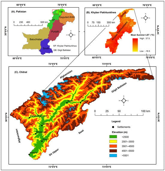
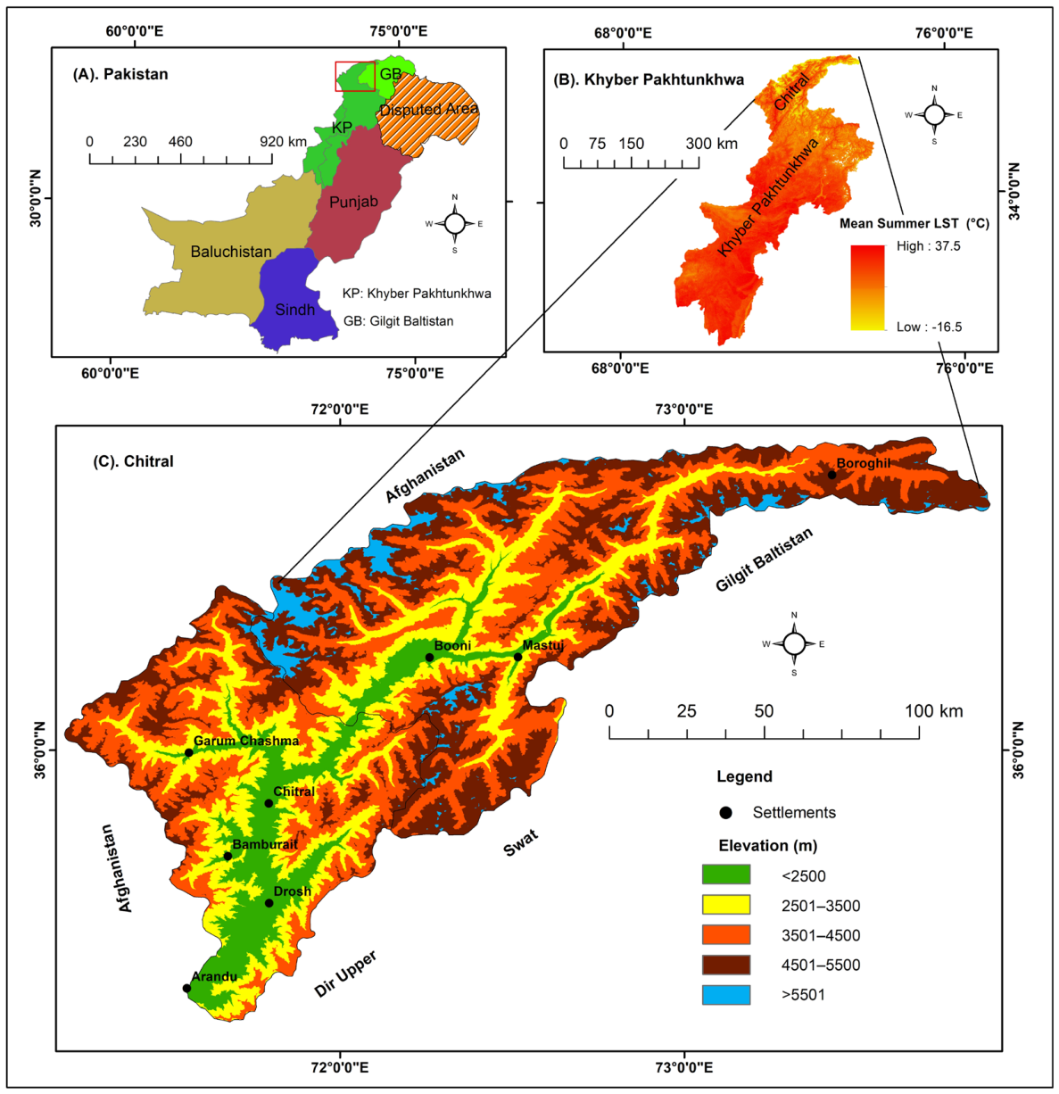
The Chitral River Basin is situated in the extreme northwestern part (35–37° N; 71–74° E) of Pakistan (Figure 1). Administratively, it is composed of two districts, Chitral Lower and Chitral Upper, situated in the Khyber Pakhtunkhwa province. It covers an area of 14,850 km2 with a density of 35 persons/km2. In 2023, Chitral was home to a population of 515,935 [78].
Figure 1.
(A) Chitral in northwestern Pakistan; (B) mean summer land surface temperature in Chitral in the north of the Khyber Pakhtunkhwa province; (C) topography of Chitral.
Chitral’s climate is the subtropical continental highland type, characterized by long cold winters and short warm summers. The semi-arid high mountain climate shows seasonal extremes in both temperature and precipitation, with a mean annual temperature of 16 °C and mean annual precipitation of 460 mm. Temperatures remain high during the entire summer season. Precipitation is inconsistent and unevenly distributed during the year, with the highest mean precipitation of 345.2 mm falling mainly as snow from Western Disturbances during the winter season from December to April, accounting for around 74% of the total annual precipitation [10]. Precipitation increases from December on and reaches a maximum in March.
The hydrological regime is predominantly determined by three main water sources: glacier and snowmelt, rainfall, and springs. Glacier and snowmelt are the principal contributors to streamflow, particularly during the spring and early summer months, followed by glacier melt during peak summer. Both play an important role in regulating seasonal water availability. The mean annual discharge of the Chitral River is about 292 m3/s, with peak flows reaching up to 856 m3/s in the summer season, while minimum flows of about 68 m3/s occur in winter. Precipitation contributes much less to streamflow because of the semi-arid conditions and high interannual variability. The mean annual precipitation is relatively low and unevenly distributed, with a significant portion occurring as winter snowfall. Mountain springs always have been the primary source of freshwater, with more than 70% of people relying on them for drinking water, agriculture, and domestic use [8,79,80]. Currently, springs are drying up and disappearing rapidly due to climate change as well as land use and land cover change (LULCC).
3. Materials and Methods
3.1. Data Sources
This study used satellite imagery analyses to describe topography, lineament density, drainage density, gridded precipitation, Land Use Land Cover (LULC), and runoff (using temperature). Secondary data were retrieved for geology, soils, and precipitation (Table 1).
Table 1.
Data sources used in this study.
3.2. Preparation of Thematic Layers
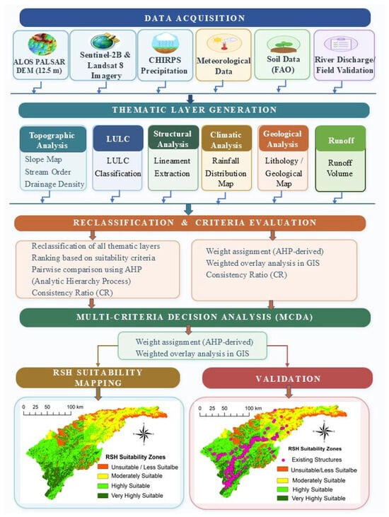
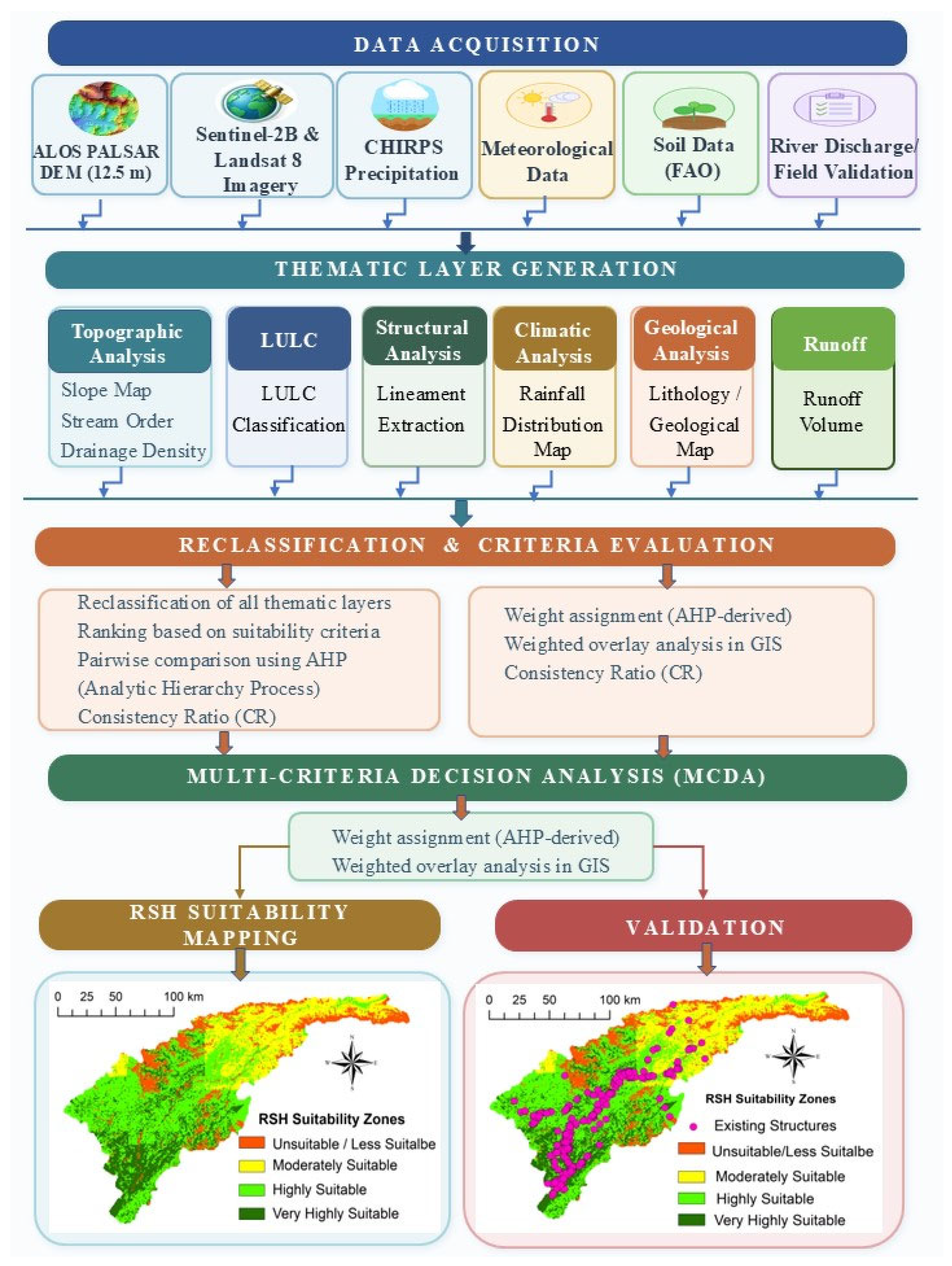
The selection of suitable sites for RSH is influenced by geomorphological, hydrological, and socio-ecological factors such as LULC [4,76,81]. In this study, eight parameters were selected that represent important characteristics of the region and are widely used in RSH studies: geology, lineament density, slope, drainage density, soil type, precipitation, LULC, and runoff (Figure 2).
Figure 2.
Methodological framework of this study.
3.2.1. Geology
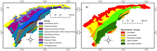
Geology significantly determines soil development in a watershed. Geological structures regulate groundwater flow, which involves the movement from surface streams to subsurface aquifers, and vice versa [12]. Data about the general geology was acquired from the Geological Survey of Pakistan and divided into nine classes: Carboniferous rocks; Cretaceous rocks; Devonian and Silurian rocks; igneous, metamorphic and mafic intrusive rocks; Late Paleozoic rocks; Mesozoic rocks; snow caps and glaciers; and unmapped areas.
3.2.2. Lineament Density
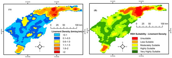
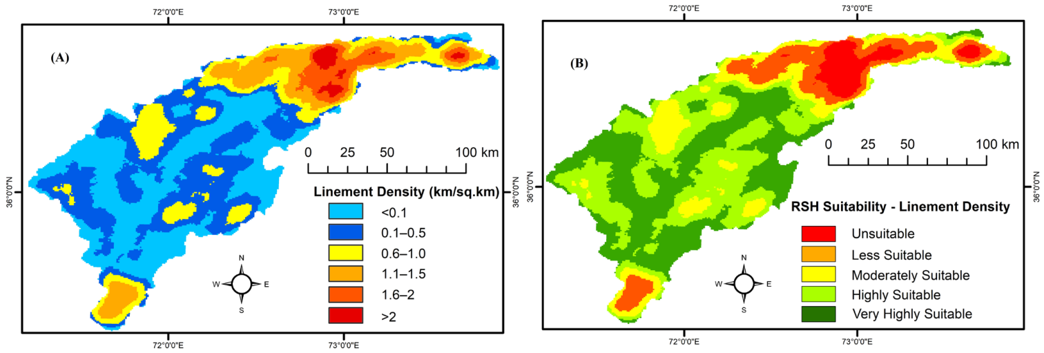
Lineaments are linear features in the landscape that represent zones of structural weakness, such as faults, joints, and fractures [75] that have a great influence on water flow, water storage, groundwater recharge, and subsurface flow of water [82]. While areas with high lineament density are not suitable for RSH, areas with low lineament density are [83]. Lineament density mapping was carried out using Landsat-8 satellite images from 2025. Principal Component Analysis (PCA), a widely used method for enhancing geological features, was employed for extraction of lineaments using the Multivariate tool, and PC2 was selected based on its improved contrast. Lineaments were delineated, converted to vector format, and used to generate/compute lineament density using the Line Density tool. The final map displays five classes of lineament densities: very low—0.5 km/km2; low—0.5–0.9 km/km2; moderate—1.0–1.5 km/km2; high—1.6–2 km/km2; very high—>2 km/km2.
3.2.3. Slope
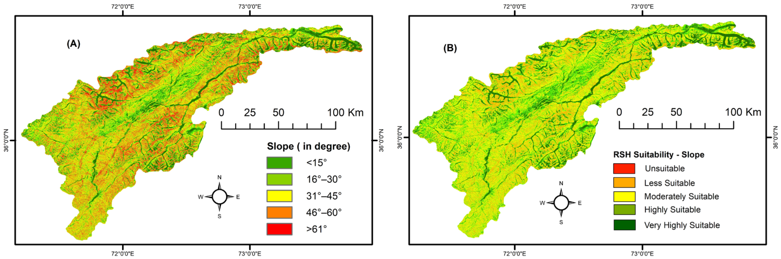
Slope is important for the determination of runoff patterns and velocities as well as groundwater recharge [12,84]. The slope map was extracted from an ALOS PALSAR digital elevation model (DEM). Slope was then divided into five classes: gentle—<15°; moderate—15–30°; steep 31–45°; very steep—45–60°; extremely steep/cliff—>60° [85].
3.2.4. Drainage Density
Runoff volume and infiltration are directly related to the drainage density; lower drainage density generally relates to lower RSH potential [84]. Drainage density is defined as the total stream length per unit catchment area. Drainage density is expressed as:
where DD is the drainage density, n is the number of streams, L is the stream length (km), and A is the watershed area (km2).
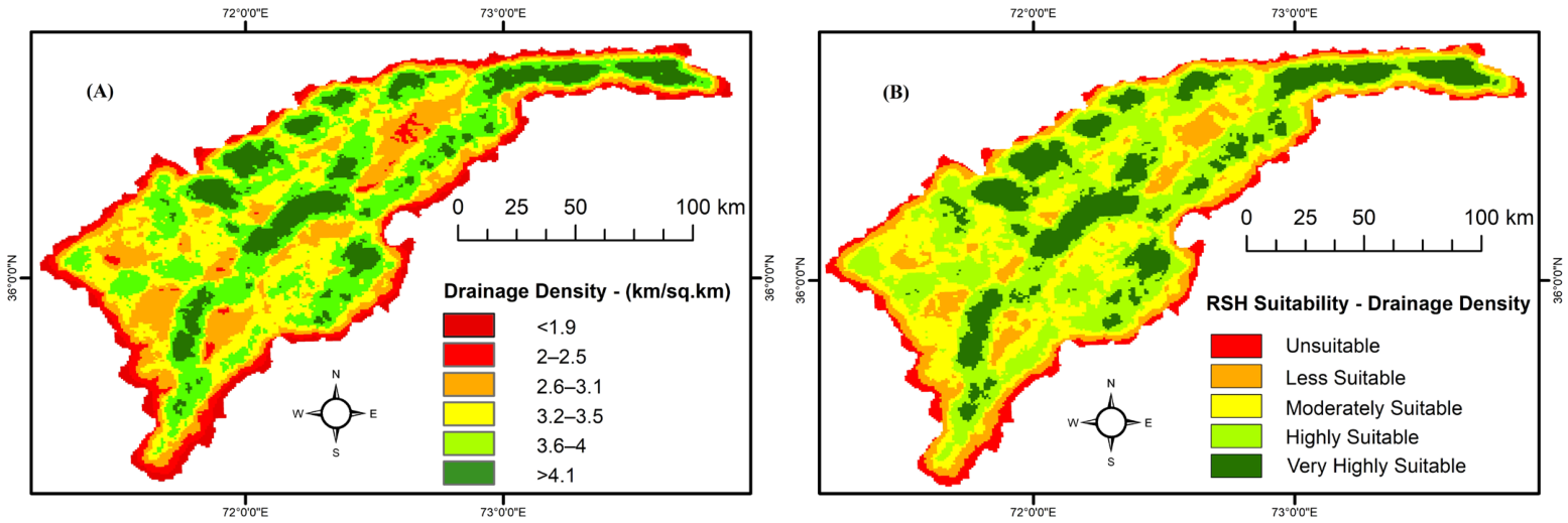
Drainage density was calculated through DEM-based hydrological modeling (Figure 3). Initially, the DEM was preprocessed using the Fill function to remove sinks. Then, flow direction was computed using the D8 (Eight direction) algorithm, followed by the Flow Accumulation tool to delineate primary drainage channels. Stream initiation was defined using a flow-accumulation threshold of 5000 cells, corresponding to a critical contributing area of approximately 0.78 km2. This threshold was selected through sensitivity testing across contributing areas ranging from 0.25 to 2.0 km2 and spatial validation against the global HydroRIVERS hydrographic database. The selected threshold provided a reasonable representation of the drainage network while minimizing ephemeral hillslope artifacts and numerical DEM noise characteristic of high-mountain landscapes. Streams were extracted and classified into eight orders using the Horton–Strahler method. The stream network was converted into vector format using the Stream to Feature tool. Finally, the drainage density was calculated using the Line Density tool. Drainage density was divided into five classes: very low—<2 km/km2; low—2–2.6 km/km2; moderate—2.7–3.3 km/km2; high—3.4–4.0 km/km2; very high—>4.0 km/km2 [41].
Figure 3.
Workflow for the DEM-based calculation of drainage density.
3.2.5. Soil Type
In soil, its texture determines the rate of infiltration, volume of runoff, and water holding capability [85]. A texture that permits a high infiltration rate is unsuitable for RSH because water easily percolates to deeper layers. Fine-grained soil with smaller pores, on the other hand, provides effective water storage [81]. Soil data obtained from the Soil and Water Conservation Department were divided into four classes: glaciers and snow caps; shallow loamy and calcareous soil; shallow, mainly loamy soil; and very shallow loamy soil and rock outcrops.
3.2.6. Precipitation
Monthly gridded precipitation data from CHIRPS were used due to the lack of ground-based observations in higher elevations. Only two met stations are available in Chitral, both situated in valley bottom locations at around 1500 m asl., but they are not adequately representing the precipitation patterns in Chitral, particularly in higher elevations.
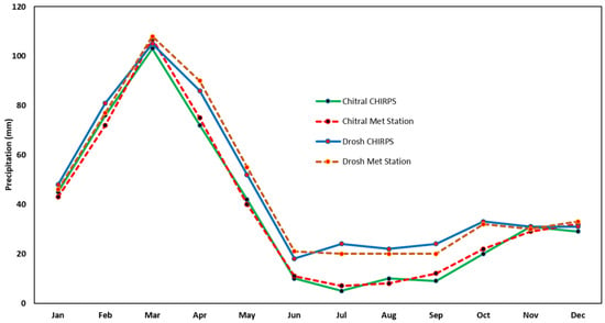
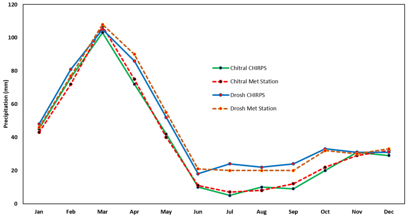
CHIRPS gridded precipitation data were converted into points, and an interpolation was performed using Inverse Distance Weighting (IDW). CHIRPS precipitation data of 0.05° resolution were preprocessed, harmonized, and downscaled to a common spatial resolution of 30 m to ensure consistency and comparability in the GIS-based AHP analysis. CHIRPS estimates for Chitral and Drosh were validated against ground-based meteorological observations from the corresponding stations (Figure 4). Following validation, monthly CHIRPS precipitation data were aggregated to derive total annual precipitation. Based on regional climate studies [12,86], and to account for the pronounced orographic moisture gradient across the eastern Hindu Kush mountain range in Chitral, total annual precipitation was divided into five classes: very low—<250 mm; low—251–350 mm; moderate—351–450 mm; high—451–550 mm; very high—>550 mm. This classification distinguishes hyper-arid valley floors (with annual precipitation below 250 mm) from high-altitude moisture accumulation zones (receiving more than 550 mm annually), primarily sustained by Western Disturbances. Furthermore, these precipitation thresholds are consistent with regional agroclimatic aridity benchmarks established by the Pakistan Meteorological Department (PMD).
Figure 4.
Validation of CHIRPS precipitation data against ground-based stations of Chitral and Drosh, Pakistan.
3.2.7. Land Use and Land Cover
LULC determines surface water runoff and infiltration [66,81]. Sentinel-2B multispectral satellite images from 2025 were classified using a supervised classification procedure and maximum likelihood algorithm. The seven LULC classes are barren land, snow/ice, water, forest, cropland, rangeland, and built-up area. The validation of the classes included field surveys and visual interpretation of high-resolution Google Earth imagery. Kappa statistics indicate an overall accuracy of >88%.
3.2.8. Runoff
The ArcSWAT model has been widely used for runoff estimation. In this study, both surface runoff and snowmelt runoff were simulated using ArcSWAT version 2012.10_8.26, with the ArcGIS 10.8 interface. Surface runoff was estimated using the Soil Conservation Service (SCS) Curve Number method, whereas snowmelt runoff was simulated using a temperature index (Degree-Day) approach. The input datasets included precipitation, temperature, topography, soil, land use/land cover (LULC), and river discharge data from the Chitral gauging station. All spatial datasets were projected to a common coordinate system using UTM Zone 43° N. A 12.5-m-reolution ALOS PALSAR DEM was used to delineate the entire watershed, which was subsequently divided into 23 sub-basins. Soil, LULC, and slope datasets were then incorporated into the SWAT model. Following the overlay of these spatial datasets, the model generated 156 hydrological response units (HRUs), with 100% spatial coverage within the delineated watershed boundaries.
The soil conservation service curve number (SCS-CN) method was developed by the United States Natural Resource Service (NRCS) in 1950 to estimate surface runoff from precipitation. It is widely used because of its simplicity, consistency, and broad applicability. The method incorporates land use/land cover (LULC), hydrologic soil group (HSG), and precipitation data. The LULC and HSG characteristics are combined to derive a Curve Number (CN), which generally ranges from 30 to 100; higher CN values indicate greater runoff potential and, consequently, a larger portion of precipitation becoming surface runoff. In this study, the SCS-CN was calculated as:
where Qsur is the depth of surface runoff (mm), P is the depth of daily precipitation (mm), Ia is the initial storage (mm), and S is the surface storage. The surface storage was calculated as follows:
where CN is the catchment curve number ranging from 0 to 100.
Snowmelt runoff can be estimated using various hydrological models, including SRM [87,88], UBC [89,90], CRHM [91,92], ARHYTHM [93], and SWAT [94,95]. Among these, the SWAT model has been widely applied to simulate and predict snowmelt runoff. Therefore, this study employed ArcSWAT with the temperature index (Degree-Day) method.
In the ArcSWAT model, daily mean air temperature (TA) is used to partition precipitation into snowfall and rain. When TA is below the snowfall threshold temperature (Tsnow), precipitation is classified as snowfall. When TA exceeds 0 °C, precipitation is classified as rainfall. Snowfall accumulates on the ground as snowpack, and the amount of water contained within the snowpack is expressed as snow water equivalent (SWE). The snowpack increases with additional snowfall and decreases through processes such as snowmelt and sublimation. The snowpack mass balance was computed using:
where SWEi is the snow water equivalent (mm H2O), Rdayi is the precipitation as snowfall (mm H2O), Esub is the snow sublimation (mm H2O), SNOmelt is the amount of snowmelt on a given day (mm H2O), and SWEi−1 is the snow water equivalent from the previous day (mm H2O).
Snow is not uniformly distributed throughout the Chitral River Basin because of snow drifting, terrain shading, and complex topography. In this study, an aerial depletion curve was used to represent the seasonal expansion and reduction of the snow-covered area as a function of the amount of snow stored in the basin. The snow-covered area in the ArcSWAT model was estimated as:
where SNOcovi is the percentage of snow-covered area, SNOCovMx is the minimum snow content corresponding to 100% snow cover, and Cov1 and Cov2 are coefficients that define the shape of the snow cover depletion curve.
Snowmelt begins when the snowpack and temperature conditions exceed the threshold required for snowmelt runoff generation. The ArcSWAT snowmelt module uses a temperature index (Degree-Day) approach to estimate snowmelt. The Degree-Day factor represents the rate of snowmelt per degree of temperature above the melting threshold and may vary with time. Snowmelt was calculated as:
where SNOmelt is the amount of snowmelt on the current day, Tmaxi is the maximum temperature on the current day, Tspi is the snowpack temperature on the current day, and SMTMP is the snowmelt onset temperature (i.e., the temperature threshold for snowmelt), and bmlti is the snowmelt factor for the current day, which was calculated using:
where SMFMN and SMFMX are the minimum and maximum snowmelt factors, corresponding to 21 June and 21 December, respectively, and i denotes the day of the year.
In SWAT, the snowpack temperature is estimated as a function of the mean air temperature of the previous day and a temperature damping factor. The snowpack temperature of the previous day influences the current snowpack temperature through the delay factor (TIMP) that accounts for factors affecting the response of snowpack temperature to changes in air temperature, including snow depth, snowpack density, and degree of exposure. The snowpack temperature was calculated as:
where Tspi is the snowpack temperature on the current day, Tspi−1 is the snowpack temperature on the previous day, Tai is the air temperature of the current day, and TIMP is the snowpack temperature delay factor.
3.2.9. Evaluation of Runoff Simulation
The SWAT Calibration and Uncertainty Program (SWAT-CUP) was used for sensitivity analysis, model calibration, and validation. SWAT-CUP incorporates several algorithms, including Parameter Solution (ParaSol), Generalized Likelihood Uncertainty Estimation (GLUE), Markov Chain Monte Carlo (MCMC), Particle Swarm Optimization (PSO), and Sequential Uncertainty Fitting 2 (SUFI-2). In this study, we used the latter. Sensitivity analysis was conducted to assess parameter uncertainty and identify the key parameters governing runoff generation and, consequently, RSH potential. Fifteen parameters were evaluated using approximately 200 simulation iterations (Table 2). Parameter sensitivity was quantified using the -statistic and -value. The SCS runoff curve number (CN2) was identified as one of the most sensitive parameters in the study area. Parameters showing high statistical significance () were prioritized for model calibration and validation.
Table 2.
SWAT parameters evaluated for sensitivity analysis in Chitral.
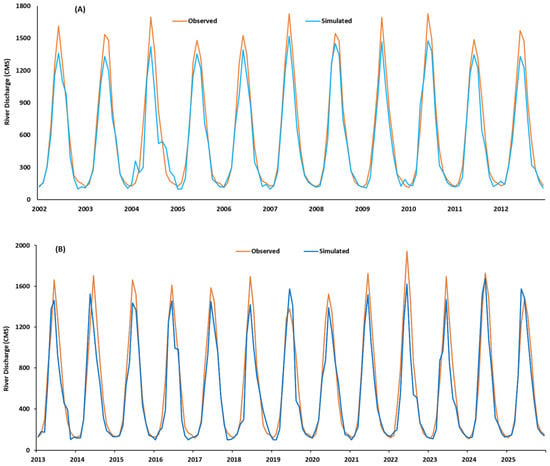
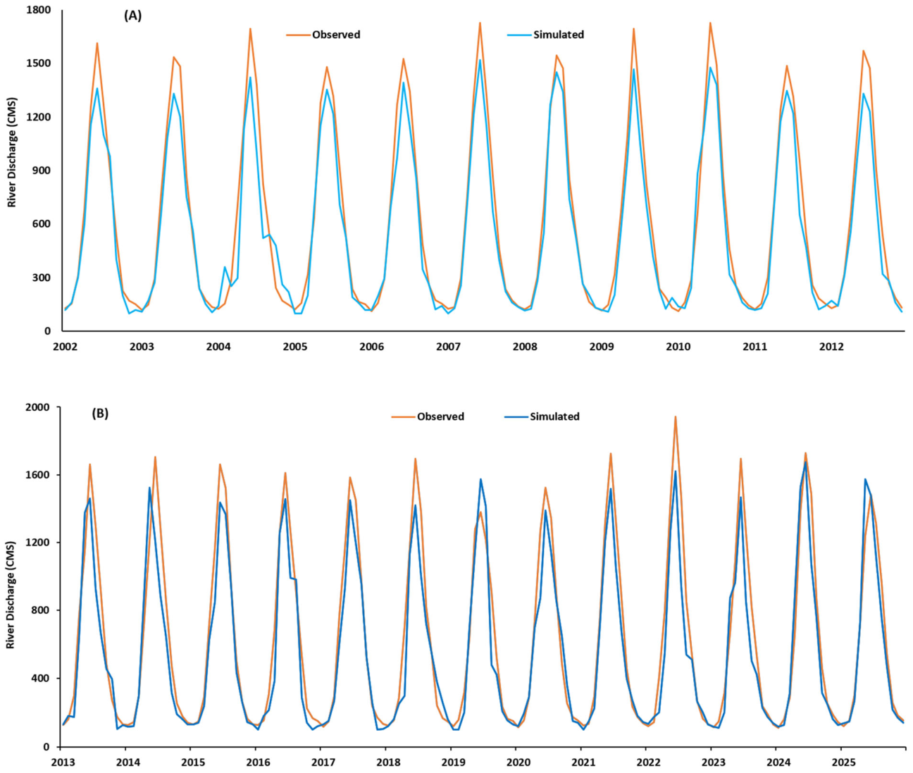
The ArcSWAT model was simulated for the period 2000–2025 using discharge data from the Chitral gauging station for model calibration and validation (Figure 5). The first two years, 2000–2001, were used as a warm-up period to minimize the effects of initial model conditions. The period 2002–2012 was used for model calibration, while 2013–2025 was used for model validation.
Figure 5.
Simulated and observed river discharge during (A) calibration and (B) validation.
The performance of the ArcSWAT model was evaluated in SWAT-CUP using several statistical metrics, including the Nash–Sutcliff Efficiency (NSE), Percentage Bias (PBIAS), coefficient of determination (R2), p-factor and r-factor based on comparisons between observed and simulated discharge.
NSE is widely used in hydrological modeling and measures the relative magnitude of the residual variance compared with variance of observed data. The NSE metric ranges from −∞ and 1.0, with the value of 1.0 indicating perfect agreement between observed and simulated values. In general, NSE values between 0.0 and 1.0 indicate acceptable model performance, whereas values ≤ 0.0 indicate poor model performance. NSE was computed as:
where and are the ith observed and simulated values, respectively, and is the mean of the observed values.
PBIAS measures the average tendency of the simulated values to overestimate or underestimate the corresponding observed values. The optimal PBIAS value is 0.0, indicating perfect agreement between the observed and simulated values. Positive values indicate model underestimation, whereas negative values indicate model overestimation. PBIAS was calculated as:
where , and are the ith observed and simulated values, respectively.
R2 describes the agreement between the simulated and observed values of each simulation. A well-performing model generally has an R2 value close to 1, whereas values greater than 0.5 are generally considered acceptable. R2 was calculated as:
The model achieved an NSE of 0.76 during calibration and 0.89 during validation (Table 3). The corresponding PBIAS values were −3.2% and 2.1%, respectively, while the R2 values were 0.87 during calibration and 0.79 during validation. Further, the model performance was also evaluated using p-factor and r-factor during calibration and validation. These statistics confirm the low model uncertainty and accurate representation of runoff generation (Table 3).
Table 3.
Model performance metrics.
3.3. Weighting and Normalization
Assigning weights to each input layer is a crucial step as results significantly rely on their accuracy. Various methods have been used in water harvesting studies, for instance, Weighted Linear Combination (WLC), Entropy Weight Method, Multi-Influencing Factor (MIF), frequency ratio, certainty factor, weights-of-evidence, fuzzy logic, and multi-influencing factor. However, the Analytic Hierarchy Process (AHP) is the most popular and widely used heuristic method. This study integrated AHP with Multi-Criteria Decision Analysis (MCDA) and GIS. All spatial datasets including the 12.5 m DEM, 30 m Landsat imagery, 10 m Sentinel-2 data, and precipitation CHIRPS (0.05°) were preprocessed, harmonized, and standardized to a common spatial resolution using appropriate resampling, upscaling and downscaling methods to ensure consistency and comparability in the GIS-based analysis. This hybrid approach employed multiple steps.
For AHP-Based RSH suitability analysis, an 8 × 8 pairwise comparison matrix (P) was constructed to evaluate the relative importance of selected thematic layers and assign quantitative weights. The criteria comprised C1: geology, C2: lineament density, C3: slope, C4: drainage density, C5: soil type, C6: precipitation, C7: LULC, and C8: runoff. The matrix is expressed as:
The Saaty’s scale assigns the rank to two selected criteria based on their significance [96]. The ranks range from 1 to 9, where 1 indicates equal importance, while 9 indicates an extremely higher importance of one criterion over the other (Table 4). For example, in this study, an area with the lowest rainfall was assigned Rank 1, and an area with the highest rainfall was assigned Rank 9, i.e., conditions favorable for RSH were assigned the highest rank. An evaluation of the pairwise ranking was carried out using past studies, observed field conditions, and local experts.
Table 4.
Scale of relative importance of criteria after Saaty [97].
During the 2024 and 2025 field campaigns, 25 experienced local experts, all older than 45 years, were selected using a stratified purposive sampling technique. The expert panel comprised five academics/researchers, five farmers, five GIS analysists, five hydrologists, and five water resource engineers. Each expert independently completed a pairwise comparison matrix using Saaty’s fundamental scale. The individual judgements were aggregated into a single group pairwise comparison matrix using the Geometric Mean Method to minimize the influence of individual judgements and derive a representative group decision. Consistency ratios were calculated for both individual and aggregated group matrices. Matrices with CR > 0.1 were reviewed and either revised or excluded from the analysis.
The normalized weight () for each criterion was calculated as:
where is the normalized weight of the nth criterion, is the geometric mean of a nth row of the pairwise comparison matrix.
The geometric mean () can be computed as:
where P is the pairwise comparison matrix.
The consistency analysis of the pairwise comparison was carried out using:
where is the consistency ratio, is the consistency index, and is the random index obtained from [50].
The consistency index was computed as:
where is the maximum eigenvalue of the pairwise comparison matrix that can be computed as:
where is the weighted sum value of the row, and is the normalized eigenvector weight of the criterion. A threshold of CR < 0.1 indicates acceptable consistency.
3.4. GIS-Based MCDA and Weighted Overlay Analysis
Following consistency validation, all thematic layers were reclassified into suitability ranks and integrated within a GIS environment using a weighted linear combination (WLC) approach. The Rainwater and Snowmelt Harvesting Potential Index (RSHPI) was computed as:
where is the weight derived from AHP, and is the rank assigned to each spatial class.
3.5. Ground Truthing of Results
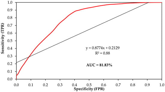
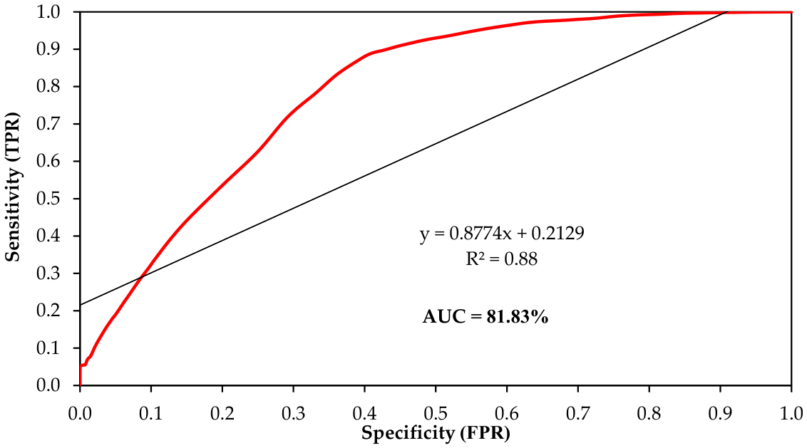
The RSH results were evaluated using the Receiver Operating Characteristic (ROC) curve and the Area Under the Curve (AUC). Suitability scores of 363 existing water-harvesting structures were compared with those at an equal number of pseudo-absence points generated from locations without existing structures. The structures included check dams, farm ponds, gully plugs, terraces, and water ponds. The pseudo-absence points were spatially constrained to locations more than 500 m from existing structures and outside active stream channels to minimize potential spatial sampling bias.
4. Results
4.1. Water Harvesting Suitability Based on Thematic Layers
4.1.1. Geology
The RSH suitability in Chitral based on geology is as follows: 42% is very highly or highly suitable; 18% is moderately suitable; and 40% is less or not suitable (Figure 6, Table 5).
Figure 6.
(A) Geology of Chitral; (B) RSH suitability based on geology.
Table 5.
RSH suitability in Chitral based on geology.
4.1.2. Lineament Density
The RSH suitability in Chitral based on lineament density is as follows: 68% is very highly or highly suitable, particularly in Lower Chitral; 15% is moderately suitable; and 17% is less or not suitable (Figure 7, Table 6).
Figure 7.
(A) Lineament density in Chitral; (B) RSH suitability based on lineament density.
Table 6.
RSH suitability in Chitral based on lineament density.
4.1.3. Slope
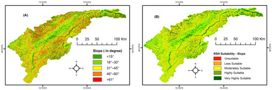
The RSH suitability in Chitral based on slope is as follows: 16% is very highly or highly suitable; 28% is moderately suitable; 56% is less or not suitable (Figure 8, Table 7).
Figure 8.
(A) Slope across Chitral; (B) RSH suitability based on slope.
Table 7.
RSH suitability in Chitral based on slope.
4.1.4. Drainage Density
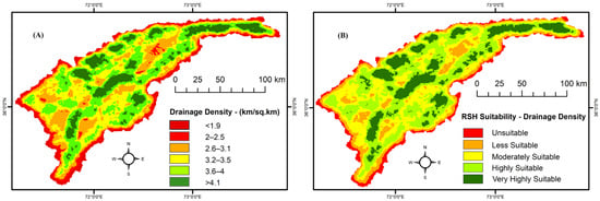
The RSH suitability in Chitral based on drainage density is as follows: 49% is very highly to highly suitable; 25% is moderately suitable; 23% is less or not suitable (Figure 9, Table 8).
Figure 9.
(A) Drainage density in Chitral; (B) RSH suitability based on drainage density.
Table 8.
RSH suitability in Chitral based on drainage density.
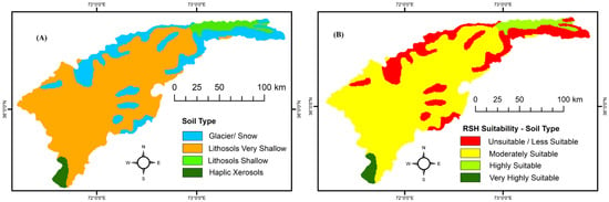
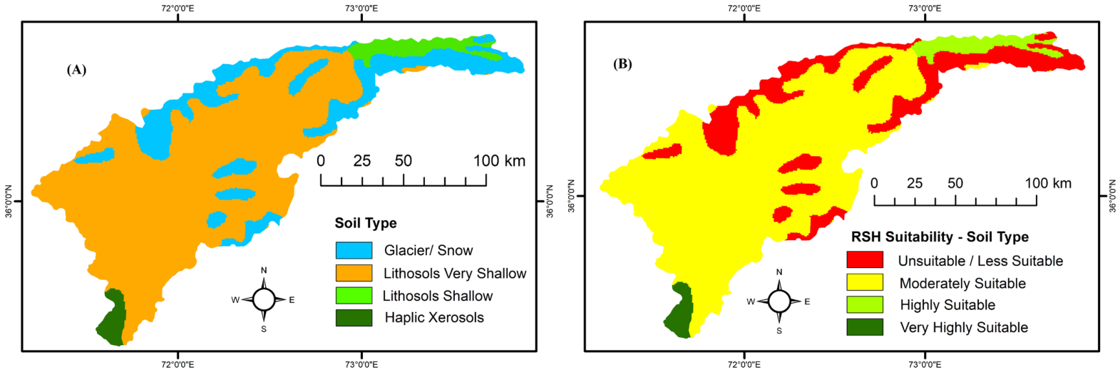
4.1.5. Soil Type
The RSH suitability in Chitral based on soil type is as follows: 7% is very highly or highly suitable; 73% is moderately suitable; and 20% is less or not suitable (Figure 10, Table 9).
Figure 10.
(A) Soil types in Chitral; (B) RSH suitability based on soil type.
Table 9.
RSH suitability in Chitral based on soil type.
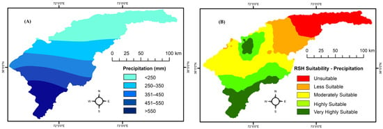
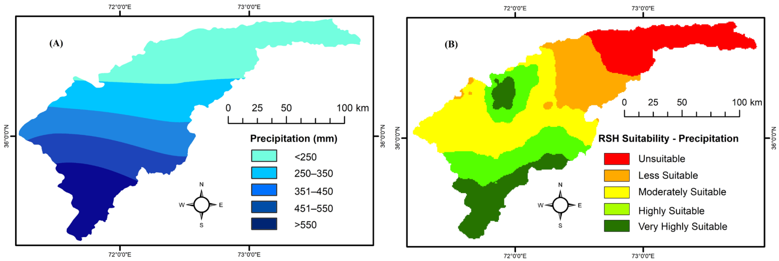
4.1.6. Precipitation
The RSH suitability in Chitral based on precipitation is as follows: 35% is very highly or highly suitable; 31% is moderately suitable; and 24% is less or not suitable (Figure 11, Table 10).
Figure 11.
(A) Mean annual precipitation in Chitral; (B) RSH suitability based on precipitation.
Table 10.
RSH suitability in Chitral based on precipitation.
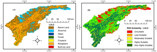
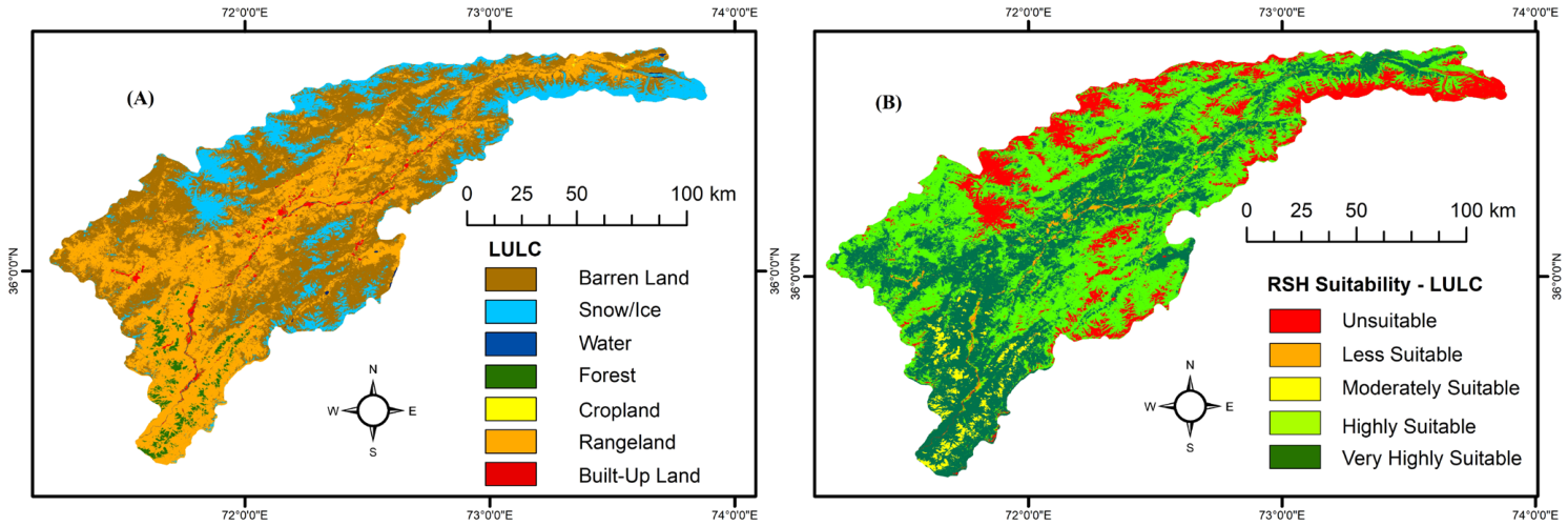
4.1.7. LULC
The RSH suitability in Chitral based on LULC is as follows: 75% is very highly or highly suitable; 8% is moderately suitable; and 17% is less or not suitable (Figure 12, Table 11).
Figure 12.
(A) LULC in Chitral; (B) RSH suitability based on LULC.
Table 11.
RSH suitability in Chitral based on LULC.
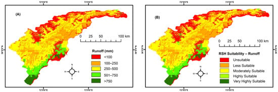
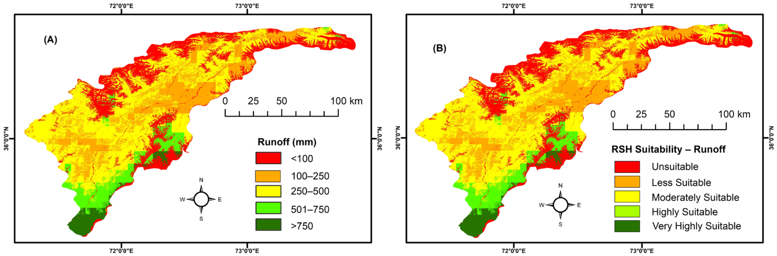
4.1.8. Runoff
The RSH suitability in Chitral based on runoff is as follows: 14% is very highly or highly suitable; 50% is moderately suitable; and 36% is less or not suitable (Figure 13, Table 12).
Figure 13.
(A) Runoff in Chitral; (B) RSH suitability based on runoff.
Table 12.
RSH suitability in Chitral based on runoff.
4.2. Thematic Layers’ Weights and Multi-Criteria Decision Analysis
To quantify the relative importance of the individual environmental characteristics in water harvesting, we carried out an AHP-based pairwise comparison (Table 13). Precipitation (W = 0.25) is the most controlling factor, followed by runoff (W = 0.22) and slope (W = 0.14). LULC (W = 0.10) and drainage density (W = 0.09) show a moderate influence, while lineament density (W = 0.07), soil type (W = 0.06), and geology (W = 0.06) have an only low influence. Reliability testing of the results included the calculation of Eigenvalue (λmax), Consistency Index (CI), Random Index (RI), and Consistency Ratio (CR). The CR (0.02) indicates that the pairwise comparison is logically consistent, and the derived weights are reliable.
Table 13.
Statistical results for selected environmental factors in estimations of RSH suitability in Chitral. PR: precipitation, LL: Land Use Land Cover, SL: slope, DD: drainage density, LD: lineament density, SO: soil type, GE: geology, RU: runoff; (a) AHP pairwise comparison matrix and normalized pairwise comparison matrix; (b) : normalized eigenvector weight, : weighted sum vector, CI: consistency index, RI: random index, CR: consistency ratio.
4.3. Water Harvesting Suitability Map
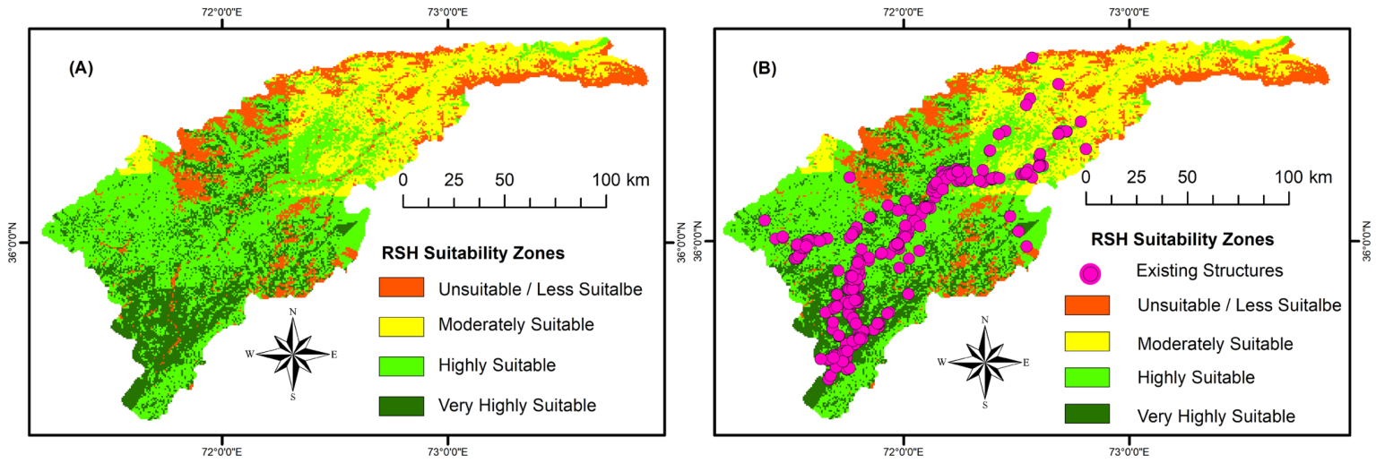
The final RSH harvesting suitability map shows that Chitral can be divided into four distinct zones (Figure 14); the zones “less suitable” and “unsuitable” were combined because the former represents only 0.2% of Chitral’s area, preventing its display in the final map: 19.1% (2836 km2) is very highly suitable; 43.8% (6504 km2) is highly suitability; 22.1% (3282 km2) is moderately suitable; and 15.0% (2228 km2) is less/unsuitable. By combining the first three zones (85%), Chitral displays an overall strong potential for RSH. Only a smaller part of Chitral is less/unsuitable for RSH because of unfavorable factors such as high elevations, steep slopes, and built-up areas.
Figure 14.
(A) RSH harvesting suitability in Chitral; (B) validation of the modeled RSH suitability zones based on traditional water harvesting structures.
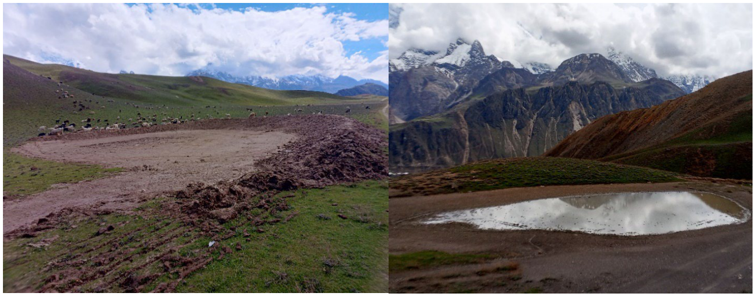
The comparison of the simulated RSH results with the locations of the 363 existing water harvesting structures revealed that 292 structures (81%) were located in areas of very high or high suitability, 45 structures (12%) were located in areas of moderate suitability, and 26 structures (7%) were located in areas of low or no suitability (Figure 14 and Figure 15). The ROC curve lies above the diagonal reference line, with an AUC of 0.82, indicating very good discriminatory performance (Figure 16). This AUC value indicates an approximately 82% probability that a randomly selected existing water-harvesting structure location has a higher RSHPI than a randomly selected location without structures. Overall, these results indicate that the proposed approach provides a reliable framework for identifying suitable zones for RSH.
Figure 15.
Traditional ponds near Qaqlast in the highly suitable RSH zone of Upper Chitral. (Photos: Z. Ahmad, April 2026).
Figure 16.
Validation using ROC curve revealed an AUC of 0.82, indicating good discriminatory performance.
5. Discussion
In our study on water harvesting in Chitral, we included runoff from rain and snow and, therefore, introduced the term “rainwater and snowmelt harvesting” (RSH). Surprisingly, we could not find any other study that estimated runoff from ice and/or snow.
Our results support previous studies that advocate for a combined assessment of climatic, hydrologic, topographic, and geologic criteria when identifying suitable zones for water harvesting [12,98,99,100]. Our findings demonstrate that, in Chitral, geology, runoff, lineament density, drainage density, and soil type all influence RSH suitability, while precipitation, runoff, and slope emerge as the key controlling parameters, with precipitation exerting the strongest influence.
The emergence of precipitation as the primary governing factor can be attributed to the semi-arid, high-mountain hydroclimatic conditions of the Chitral River basin, which functions as a source-limited moisture system. Unlike transport-limited humid regions, where hydrological processes are generally less constrained by atmospheric moisture availability, such processes in Chitral are strongly governed by atmospheric moisture supply rather than landscape transport capacity. Precipitation is sparse, highly variable, and often erratic, while the basin’s hydrological yield depends substantially on high-altitude winter snowfall [10]. Thus, precipitation represents the primary physical gateway determining the macro-scale feasibility of RSH in the CRB. The southern parts of Chitral receive greater amounts of summer rainfall associated with monsoonal depressions, which helps explain the concentration of very high or high RSH suitability zones in this region. In contrast, middle and upper parts of Chitral have a more arid climate and receive a greater portion of their precipitation during the winter from Western Disturbances [10], resulting in comparatively lower RSH suitability.
Furthermore, slope is particularly important in Chitral because of its complex topography that ranges from relatively flat valley bottoms to extremely steep alpine terrain. Slope influences runoff velocity, infiltration opportunity, water accumulation, erosion, and the physical feasibility and spatial distribution of water-harvesting structures. Our findings that slope is a highly influential factor in determining water harvesting suitability are consistent with previous assessments [21,101,102,103].
An interesting contribution to the selection of suitable RWH sites comes from a study in Iraq, which advocates incorporating ecological criteria relevant to ecosystem health, including temperature, light, wind speed and direction, humidity, and evaporation [42,104]. Among these criteria, temperature and light were identified as the most influential factors. The inclusion of these ecological criteria altered the ranking of sites compared with rankings based solely on conventional suitability criteria.
The integrated temperature index (Degree-Day) and AHP-based MCDA framework provides an effective tool for RSH suitability mapping. However, while it is computationally effective and suitable for data-scarce regions like Chitral, it simplifies complex snowpack ablation dynamics by relying primarily on temperature and precipitation while omitting energy balance variables and other parameters such as solar radiation, ground heat flux, snow depth, freeze–thaw cycles, wind speed etc. Additionally, AHP-based MCDA relies on expert judgment for criteria weighting, and the spatial thematic layers (e.g., geology, lineament density, drainage density, and slope) are subject to the temporal and spatial resolution of available satellite datasets, which may smooth out micro-topographic or localized geological variations.
Our findings show that 63% of Chitral is classified as very highly or highly suitable for RSH, while an additional 22% is still moderately suitable. In contrast, a study conducted in Gilgit-Baltistan, a snow-dominated region of the HKH of Pakistan that borders Chitral to the east, found that only 4% of the region is highly suitable for RWH, and 40% is moderately suitable [99]. One possible explanation for this discrepancy in water harvesting suitability is the difference in methodological approaches. The Gilgit-Baltistan study estimated snowmelt from rainfall depths and direct runoff using the SCS-CN method, whereas our approach explicitly incorporates snowmelt runoff as a separate hydrological component. Furthermore, the study does not clearly explain the criteria or thresholds used to define the high, medium, low, and unsuitable suitability classes. A different study conducted in the Ghazi Tehsil, Khyber Pakhtunkhwa, classified 28% of the region as suitable, 52% less suitable, and 20% not suitable using the SCS-CN method [12]. Again, the contribution of snowmelt to runoff was not considered in the analysis.
An interesting water harvesting method and adaptation to seasonal water scarcity was developed by Chewang Norphelin in Ladakh of the Indian Himalaya in the mid-1990s in the form of man-made “artificial glaciers” that slowly release meltwater during the spring and summer [105,106,107,108].
6. Conclusions
Water harvesting provides a viable, practical, and climate-resilient strategy for sustainable water resource management in high-mountain regions vulnerable to climate change and population growth. Surprisingly, water harvesting suitability studies in snow-dominated mountain regions have largely focused on rainwater, despite the substantial contribution of snowmelt and, in some basins, glacier melt to surface runoff. Incorporating snowmelt based on temperature data therefore represents an important step toward improving water harvesting suitability assessments in mountain environments.
Several environmental parameters—geology, lineament density, slope, drainage density, soil type, precipitation, LULC and runoff—play critical roles in controlling surface runoff generation, infiltration potential, and water storage capacity. The integration of a temperature index (Degree-Day) and AHP-based MCDA approach with RS/GIS techniques enables the identification and spatial delineation of RSH suitability zones. In semi-arid Chitral, where snow covers the ground for many months of the year, rainwater and snowmelt harvesting (RSH) represent a promising strategy for addressing water scarcity. More than 60% of the area is either very highly or highly suitable for RSH, while an additional 22% is moderately suitable. The resulting suitability map provides a valuable decision-support tool for stakeholders by identifying priority areas for harvesting interventions aimed at enhancing water availability for agriculture and domestic use. These maps can thus support the development of strategies to address water scarcity and strengthen climate resilience in the Eastern Hindu Kush of northern Pakistan.
However, several methodological limitations remain. Future research should address these limitations in four key directions:
- First, studies should incorporate high-resolution satellite and UAV imagery, together with hydrogeological datasets such as snow water equivalent, topographic wetness index, soil infiltration capacity, and snow cover area and depth, to refine input parameterization.
- Second, advanced modeling approaches should be explored, including the integration of physically based energy-balance snowmelt models (e.g., DHSVM and iSNOBAL) with machine learning and hybrid decision-making methods (e.g., Random Forest and Fuzzy-AHP) to improve runoff estimation and reduce criteria subjectivity in criteria weighting.
- Third, research should bridge the gap between macro-scale suitability modeling and site-specific engineering design by identifying precise locations for structural water-harvesting interventions, such as check dams, snow-storage basins, and aquifer recharge shafts, supported by ground-based geophysical surveys and field validation.
- Fourth, suitability assessments should be downscaled from regional scale to the tehsil and village-council levels to provide actionable decision-support tools for municipal water authorities and local planners.
- Fifth, water-harvesting research in high-mountain environments should also account for runoff contributions from glaciers and snow. We therefore propose an integrated approach to rainwater, ice- and snowmelt harvesting (RISH) for high-mountain regions.
Author Contributions
M., Z.A. and U.K.—conceptualization; M. and Z.A.—fieldwork; F.R., I. and Z.A.—formal analyses; Z.A. and U.K.—visualization; all authors—writing. All authors have read and agreed to the published version of the manuscript.
Funding
This research received no external funding.
Institutional Review Board Statement
Not applicable.
Informed Consent Statement
Not applicable.
Data Availability Statement
The raw data supporting the conclusions of this article will be made available by the authors on request.
Conflicts of Interest
The authors declare no conflicts of interest.
References
- Andualem, T.G.; Demeke, G.G.; Ahmed, I.; Dar, M.A.; Yibeltal, M. Groundwater recharge estimation using empirical methods from rainfall and streamflow records. J. Hydrol. Reg. Studies 2021, 37, 100917. [Google Scholar] [CrossRef] [Scilit]
- Haider, S.; Haq, F.; Kontakiotis, G.; Ahmad, Z.; Besiou, E.; Malik, S.M.; Antonarakou, A.; Altaf, F. Spatiotemporal analysis of temperature variability and trends in the Cholistan desert, Pakistan: Implications for water management and sustainable development. Environ. Earth Sci. 2025, 84, 665. [Google Scholar] [CrossRef] [Scilit]
- World Bank. The Economics of Water Scarcity: GDP Impacts and Social Sustainability in Fragile Contexts; World Bank Open Knowledge Repository: Washington, DC, USA, 2026. [Google Scholar]
- Buraihi, F.H.; Shariff, A.R.M. Selection of rainwater harvesting sites using remote sensing and GIS techniques: A case study of Kirkuk, Iraq. J. Teknol. 2015, 76, 75–81. [Google Scholar] [CrossRef] [Scilit]
- Adham, A.; Riksen, M.; Ouessar, M.; Ritsema, C.J. A methodology to assess and evaluate rainwater harvesting techniques in (semi-)arid regions. Water 2016, 8, 198. [Google Scholar] [CrossRef] [Scilit]
- Tolossa, T.T.; Abebe, F.B.; Girma, A.A. Review: Rainwater harvesting technology practices and implication of climate change characteristics in Eastern Ethiopia. Cogent Food Agric. 2020, 6, 1724354. [Google Scholar] [CrossRef] [Scilit]
- UN-Water. World Enters “Era of Global Water Bankruptcy”: A Post-Crisis Reality Report; United Nations University Institute for Water, Environment and Health: Richmond Hill, ON, Canada, 2026. [Google Scholar]
- Ahmad, Z.; Fazlur-Rahman; Dittmann, A.; Hussain, K.; Ihsanullah, I. Water crisis in the Eastern Hindu Kush: A micro-level study of community-based irrigation water management in the mountain village Kushum, Pakistan. Erdkunde 2020, 74, 59–79. [Google Scholar] [CrossRef] [Scilit]
- UNICEF. Water Scarcity and Human Displacement: Projections for 2030; UNICEF: New York, NY, USA, 2025. [Google Scholar]
- Ahmad, Z.; Altaf, F.; Kamp, U.; Rahman, F.; Malik, S.M. Glacier recession and climate change in Chitral, Eastern Hindu Kush Mountains of Pakistan, between 1992 and 2022. Geosciences 2025, 15, 167. [Google Scholar] [CrossRef] [Scilit]
- Hassan, I. Rainwater harvesting: An alternative water supply in the future for Pakistan. J. Biodivers. Environ. Sci. 2016, 8, 213–222. [Google Scholar]
- Khan, D.; Raziq, A.; Young, H.W.V.; Sardar, T.; Liou, Y.A. Identifying potential sites for rainwater harvesting structures in Ghazi Tehsil, Khyber Pakhtunkhwa, Pakistan, using a geospatial approach. Remote Sens. 2022, 14, 5008. [Google Scholar] [CrossRef] [Scilit]
- Asian Development Bank (ADB). Asian Water Development Outlook 2025: Advancing Water Security Across Asia and the Pacific; Asian Development Bank: Manila, Philippines, 2025; Available online: https://www.adb.org/awdo/editions/2025 (accessed on 25 October 2026).
- Zeshan, M.; Shakeel, M. Water crisis in Pakistan: A dynamic CGE-water model. Res. Sq. 2021, 1–23. [Google Scholar] [CrossRef] [Scilit]
- Ahmad, Z.; Malik, S.M.; Mehran; Hussain, K.; Altaf, F. Resilience and innovation in mountain agriculture: Exploring the drivers of agricultural transformation in the Eastern Hindu Kush, Lotkuh, Pakistan. J. Asian Dev. Studies 2023, 12, 158–177. [Google Scholar] [CrossRef] [Scilit]
- Napoli, M.; Cecchi, S.; Orlandini, S.; Zanchi, C.A. Determining potential rainwater harvesting sites using a continuous runoff potential accounting procedure and GIS techniques in central Italy. Agric. Water Manag. 2014, 141, 55–65. [Google Scholar] [CrossRef] [Scilit]
- Kumar, A.; Kanga, S.; Taloor, A.K.; Singh, S.K.; Durin, B. Surface runoff estimation of Sind river basin using integrated SCS-CN and GIS techniques. HydroResearch 2021, 4, 61–74. [Google Scholar] [CrossRef] [Scilit]
- Oweis, T.Y.; Prinz, D.; Hachum, A.Y. Rainwater Harvesting for Agriculture in the Dry Areas; CRC Press/Balkema: Boca Raton, FL, USA, 2012. [Google Scholar] [CrossRef] [Scilit]
- Sazakli, E.; Alexopoulos, A.; Leotsinidis, M. Rainwater harvesting, quality assessment and utilization in Kefalonia Island, Greece. Water Res. 2007, 41, 2039–2047. [Google Scholar] [CrossRef] [Scilit]
- Ammar, A.; Riksen, M.; Ouessar, M.; Ritsema, C. Identification of suitable sites for rainwater harvesting structures in arid and semi-arid regions: A review. Int. Soil Water Conserv. Res. 2016, 4, 108–120. [Google Scholar] [CrossRef] [Scilit]
- Al-Marsumi, K.; Al Shamma, A. Selection of suitable sites for water harvesting structures in a flood-prone area using remote sensing and GIS—Case study. J. Environ. Earth Sci. 2017, 7, 91–100. [Google Scholar]
- Hassan, W.H.; Mahdi, K.; Kadhim, Z.K. GIS-based multi-criteria decision making for identifying rainwater harvesting sites. Appl. Water Sci. 2025, 15, 45. [Google Scholar] [CrossRef] [Scilit]
- Pandey, D.N.; Gupta, A.K.; Anderson, D.M. Rainwater harvesting as an adaptation to climate change. Curr. Sci. 2003, 85, 46–59. [Google Scholar]
- Biazin, B.; Sterk, G.; Temesgen, M.; Abdulkedir, A.; Stroosnijder, L. Rainwater harvesting and management in rainfed agricultural systems in sub-Saharan Africa—A review. Phys. Chem. Earth 2012, 47–48, 139–151. [Google Scholar] [CrossRef] [Scilit]
- Gebreyess, B.F.; Amare, A. Water harvesting technologies in semi-arid and arid areas. J. Degrad. Min. Lands Manag. 2019, 7, 1921–1928. [Google Scholar] [CrossRef] [Scilit]
- Ahmed, S.; Jesson, M.; Sharifi, S. Selection frameworks for potential rainwater harvesting sites in arid and semi-arid regions: A systematic literature review. Water 2023, 15, 2782. [Google Scholar] [CrossRef] [Scilit]
- Raimondi, A.; Quinn, R.; Abhijith, G.R.; Becciu, G.; Ostfeld, A. Rainwater harvesting and treatment: State of the art and perspectives. Water 2023, 15, 1518. [Google Scholar] [CrossRef] [Scilit]
- Umukiza, E.; Ntole, R.; Chikavumbwa, S.R.; Bwambale, E.; Sibale, D.; Jeremiah, Z.; Appolonio, C.; Petroselli, A. Rainwater harvesting in arid and semi-arid lands of Africa: Challenges and opportunities. Acta Sci. Pol. 2023, 22, 41–52. [Google Scholar] [CrossRef] [Scilit]
- Bey, S.; Thabah, A.K.; Basumatary, P.; Hazarika, A.; Nath, A.; Das, A.K.; Nath, A.J. Dying traditional water harvesting systems in the Indian Himalayan region: Historical significance, current challenges, and potential solutions. Int. J. Ecol. Environ. Sci. 2025, 51, 487–508. [Google Scholar] [CrossRef] [Scilit]
- Haque, M.M.; Rahman, A.; Samali, B. Evaluation of climate change impacts on rainwater harvesting. J. Clean. Prod. 2016, 137, 60–69. [Google Scholar] [CrossRef] [Scilit]
- Preeti, P.; Shendryk, Y.; Rahman, A. Identification of suitable sites using GIS for rainwater harvesting structures to meet irrigation demand. Water 2022, 14, 3480. [Google Scholar] [CrossRef] [Scilit]
- Matomela, N.; Li, T.; Ikhumhen, H.O. Siting of rainwater harvesting potential sites in arid or semi-arid watersheds using GIS-based techniques. Environ. Processes 2020, 7, 631–652. [Google Scholar] [CrossRef] [Scilit]
- Mahmoud, S.H.; Adamowski, J.; Alazba, A.A.; El-Gindy, A.M. Rainwater harvesting for the management of agricultural droughts in arid and semi-arid regions. Paddy Water Environ. 2016, 14, 231–246. [Google Scholar] [CrossRef] [Scilit]
- Yosef, B.A.; Asmamaw, D.K. Rainwater harvesting: An option for dry land agriculture in arid and semi-arid Ethiopia. Int. J. Water Resour. Environ. Eng. 2015, 7, 17–28. [Google Scholar] [CrossRef] [Scilit]
- Grum, B.; Hessel, R.; Kessler, A.; Woldearegay, K.; Yazew, E.; Ritsema, C.; Geissen, V. A decision support approach for the selection and implementation of water harvesting techniques in arid and semi-arid regions. Agric. Water Manag. 2016, 173, 35–47. [Google Scholar] [CrossRef] [Scilit]
- Alene, A.; Yibeltal, M.; Abera, A.; Andualem, T.G.; Lee, S.S. Identifying rainwater harvesting sites using integrated GIS and a multi-criteria evaluation approach in semi-arid areas of Ethiopia. Appl. Water Sci. 2022, 12, 238. [Google Scholar] [CrossRef] [Scilit]
- Bera, A.; Mukhopadhyay, B.P. Identification of suitable sites for surface rainwater harvesting in the drought-prone Kumari River basin, India, in the context of irrigation water management. J. Hydrol. 2023, 621, 129655. [Google Scholar] [CrossRef] [Scilit]
- Toosi, A.S.; Tousi, E.G.; Ghassemi, S.A.; Cheshomi, A.; Alaghmand, S. A multi-criteria decision analysis approach towards efficient rainwater harvesting. J. Hydrol. 2020, 582, 124501. [Google Scholar] [CrossRef] [Scilit]
- Alkaradaghi, K.; Hamamin, D.; Karim, H.; Al-Ansari, N.; Ali, S.S.; Laue, J.; Ali, T. Geospatial technique integrated with MCDM models for selecting potential sites for harvesting rainwater in the semi-arid regions. Water Air Soil Pollut. 2022, 233, 313. [Google Scholar] [CrossRef] [Scilit]
- Al-Hasani, B.; Abdellatif, M.; Carnacina, I.; Harris, C.; Al-Quraishi, A.; Maaroof, B.F.; Zubaidi, S.L. Integrated geospatial approach for adaptive rainwater harvesting site selection under the impact of climate change. Stoch. Environ. Res. Risk Assess. 2024, 38, 1009–1033. [Google Scholar] [CrossRef] [Scilit]
- Al-Hasani, B.; Abdellatif, M.; Carnacina, I.; Harris, C.; Maaroof, B.F.; Zubaidi, S.L. Rainwater harvesting site assessment using geospatial technologies in a semi-arid region: Toward water sustainability. Water 2025, 17, 2317. [Google Scholar] [CrossRef] [Scilit]
- Ahmed, S.; Jesson, M.; Sharifi, S. A novel, ecology-inclusive, hybrid framework for rainwater harvesting site selection in arid and semi-arid regions. Water Resour. Manag. 2025, 39, 2419–2439. [Google Scholar] [CrossRef] [Scilit]
- Dahal, R.; Ban, J.; Makaju, S.; Shrestha, R.S.; Dwa, N. Rainwater Harvesting (RWH) in Nepal: A Case Study on Social Acceptability and Performance Evaluation of RWH Schemes Implemented in Syangja and Tanahun Districts. Bachelor’s Thesis, Tribhuvan University, Pakhora, Nepal, 2010. [Google Scholar] [CrossRef]
- Forzini, E.; Piemontese, L.; Bresci, E.; Barthold, B.; Bielser, F.; Sylvestre, M.; Adhikari, N.; Pun, S.; Castelli, G. Identification of suitable sites for traditional pokhari water harvesting in mountain communities of the Himalaya. Hydrol. Res. 2022, 53, 1340. [Google Scholar] [CrossRef] [Scilit]
- Aladenola, O.O.; Adeboye, O.B. Assessing the potential for rainwater harvesting. Water Resour. Manag. 2010, 24, 2129–2137. [Google Scholar] [CrossRef] [Scilit]
- Jan, I.; Khan, S.; Mahmood, T. Effects of rainwater harvesting on yield of wheat and maize crops in Pakistan. Pak. J. Agric. Agric. Eng. Vet. Sci. 2021, 37, 29–35. [Google Scholar] [CrossRef] [Scilit]
- Noor, N.; Wanchang, Z.; Chandio, N.H.; Mahar, G.A.; Rahman, G. Conservation and harvesting of rainwater for sustainable agriculture in Kachho, Sindh, Pakistan. Ecol. Quest. 2025, 36, 43–50. [Google Scholar] [CrossRef] [Scilit]
- Judeh, T.; Shahrour, I. Rainwater harvesting to address current and forecasted domestic water scarcity: Application to arid and semi-arid areas. Water 2021, 13, 3583. [Google Scholar] [CrossRef] [Scilit]
- Judeh, T.; Shahrour, I.; Comair, F. Smart rainwater harvesting for sustainable potable water supply in arid and semi-arid areas. Sustainability 2022, 14, 9271. [Google Scholar] [CrossRef] [Scilit]
- Kahinda, J.M.; Taigbenu, A.E. Rainwater harvesting in South Africa: Challenges and opportunities. Phys. Chem. Earth 2011, 36, 968–976. [Google Scholar] [CrossRef] [Scilit]
- Zia, S.; Mustafa, A.; Sial, S. Traditional Water Harvesting Techniques and Practices in Pakistan; Women’s Resource Centre: Lahore, Pakistan, 2005. [Google Scholar]
- Kumar, R.; Jhajharia, D.; Ram, D.; Chand, S.; Kumar, M.; Shukla, R.M. Rainwater harvesting in north-western Himalayan region: A case study. J. Soil Conserv. 2012, 11, 323–328. [Google Scholar]
- Vaidya, R.A. The role of water storage in adaptation to climate change in the HKH region. Sustain. Mt. Dev. 2009, 56, 10–13. [Google Scholar]
- Kumar, R.; Thaman, S.; Agrawal, G.; Poonam, S. Rain water harvesting and ground water recharging in north western Himalayan region for sustainable agricultural productivity. Univers. J. Environ. Res. Technol. 2011, 1, 539–544. [Google Scholar]
- Bhattarai, N.; Dahal, S.; Thapa, S.; Pradhananga, S.; Karky, B.S.; Rawat, R.S.; Windhorst, K.; Watanabe, T.; Thapa, R.B.; Avtar, R. Forest fire in the Hindu Kush Himalaya: A major challenge for climate action. J. For. Livelihood 2022, 21, 14–31. [Google Scholar] [CrossRef] [Scilit]
- Hussain, A.; Mahapatra, B.; Rasul, G. Adaptation in mountain agriculture: Food security in the Hindu-Kush Himalaya (HKH) region. In Status of Climate Change Adaptation in Asia and the Pacific; Alam, M., Lee, J., Sawhney, P., Eds.; Springer: Cham, Switzerland, 2019; pp. 211–236. [Google Scholar]
- Khadka, K.; Khanal, S.; Dhakal, M.P.; Bhuchar, S.; Agrawal, N.K. Gender-responsive solutions for managing drought in the Hindu Kush Himalaya. In Forecasting, Monitoring, and Managing Risk, Integrated Drought Management 2; Singh, V.P., Jhajharia, D., Mirabbasi, R., Kumar, R., Eds.; CRC Press: Boca Raton, FL, USA, 2023; pp. 629–647. [Google Scholar]
- Vaidya, R.A. Governance and management of local water storage in the Hindu Kush Himalayas. Int. J. Water Resour. 2015, 31, 253–268. [Google Scholar] [CrossRef] [Scilit]
- Kadam, A.K.; Kale, S.S.; Pande, N.N.; Pawar, N.J.; Sankhua, R.N. Identifying potential rainwater harvesting sites of a semi-arid basaltic region of Western India using SCS-CN method. Water Resour. Manag. 2012, 26, 2537–2554. [Google Scholar] [CrossRef] [Scilit]
- Yegizaw, E.S.; Ejegu, M.A.; Tolossa, A.T.; Teka, A.H.; Andualem, T.G.; Tegegne, M.A.; Walle, W.M.; Shibeshie, S.E.; Dirar, T.M. Geospatial and AHP approach for rainwater harvesting site identification in drought-prone areas, South Gonder Zone, Northwest Ethiopia. J. Indian Soc. Remote Sens. 2022, 50, 1321–1331. [Google Scholar] [CrossRef] [Scilit]
- Zheng, X.; Sarwar, A.; Islam, F.; Majid, A.; Tariq, A.; Ali, M.; Gulzar, S.; Khan, M.I.; Sardar Ali, M.A.; Israr, M.; et al. Rainwater harvesting for agriculture development using multi-influence factor and fuzzy overlay techniques. Environ. Res. 2023, 238, 117189. [Google Scholar] [CrossRef] [Scilit]
- Adham, A.; Sayl, K.N.; Abed, R.; Abdeladhim, M.A.; Wesseling, J.G.; Riksen, M.; Ritsema, C.J. A GIS-based approach for identifying potential sites for harvesting rainwater in the Western Desert of Iraq. Int. Soil Water Conserv. Res. 2018, 6, 297–304. [Google Scholar] [CrossRef] [Scilit]
- Sayl, K.N.; Mohammed, A.S.; Ahmed, A.D. GIS-based approach for rainwater harvesting site selection. IOP Conf. Ser. Mater. Sci. Eng. 2020, 737, 012246. [Google Scholar] [CrossRef] [Scilit]
- Khashei-Siuki, A.; Sharifan, H. Comparison of AHP and FAHP methods in determining suitable areas for drinking water harvesting in Birjand aquifer, Iran. Groundw. Sustain. Dev. 2020, 10, 100328. [Google Scholar] [CrossRef] [Scilit]
- Ezzeldin, M.; Sinichenko, E.K.; Gritsuk, I.I. Determining the suitability of rainwater harvesting for the achievement of sustainable development goals in Wadi Watir, Egypt using GIS techniques. J. Environ. Manag. 2022, 313, 114990. [Google Scholar] [CrossRef] [Scilit]
- Al-Ruzouq, R.; Shanableh, A.; Yilmaz, A.G.; Idris, A.; Mukherjee, S.; Khalil, M.A.; Gibril, M.B.A. Dam Site Suitability Mapping and Analysis Using an Integrated GIS and Machine Learning Approach. Water 2019, 11, 1880. [Google Scholar] [CrossRef] [Scilit]
- Madani, A.; Niyazi, B. Groundwater potential mapping using remote sensing and Random Forest machine learning model: A case study from Lower Part of Wadi Yalamlam, Western Saudi Arabia. Sustainability 2023, 15, 2772. [Google Scholar] [CrossRef] [Scilit]
- Mahmoud, S.H.; Alazba, A.A. The potential of in situ rainwater harvesting in arid regions: Developing a methodology to identify suitable areas using GIS-based decision support system. Arab. J. Geosci. 2015, 8, 5167–5179. [Google Scholar] [CrossRef] [Scilit]
- Singh, L.K.; Jha, M.K.; Chowdary, V.M. Multi-criteria analysis and GIS modeling for identifying prospective water harvesting and artificial recharge sites for sustainable water supply. J. Clean. Prod. 2017, 142, 1436–1456. [Google Scholar] [CrossRef] [Scilit]
- Tiwari, K.; Goyal, R.; Sarkar, A. GIS-based methodology for identification of suitable locations for rainwater harvesting structures. Water Resour. Manag. 2018, 32, 1811–1825. [Google Scholar] [CrossRef] [Scilit]
- Ibrahim, G.R.F.; Rasul, A.; Hamid, A.A.; Ali, Z.F.; Dewana, A.A. Suitable site selection for rainwater harvesting and storage case study using Dohuk Governorate. Water 2019, 11, 864. [Google Scholar] [CrossRef] [Scilit]
- Elewa, H.H.; Zelenakova, M.; Nosair, A.M. Integration of the analytical hierarchy process and GIS spatial distribution model to determine the possibility of runoff water harvesting in dry regions: Wadi Watir in Sinai as a case study. Water 2021, 13, 804. [Google Scholar] [CrossRef] [Scilit]
- Roy, S.; Hazra, S.; Chanda, A. Identifying rainwater harvesting structure sites using MCDM-based GIS approach: A mitigation measure for drought in sub-humid red and lateritic zones of West Bengal, India. Arab. J. Geosci. 2022, 15, 784. [Google Scholar] [CrossRef] [Scilit]
- Ejegu, M.A.; Yegizaw, E.S. Potential rainwater harvesting suitable land selection and management using GIS with MCDA in Ebenat District, Northwestern Ethiopia. J. Degrad. Min. Lands Manag. 2020, 8, 2537–2549. [Google Scholar] [CrossRef] [Scilit]
- Ullah, S.; Iqbal, M.; Waseem, M.; Abbas, A.; Masood, M.; Nabi, G.; Tariq, M.A.U.R.; Sadam, M. Potential sites for rainwater harvesting focusing on sustainable development goals using GIS. Sustainability 2024, 16, 9266. [Google Scholar] [CrossRef] [Scilit]
- Wu, R.-S.; Molina, G.L.L.; Hussain, F. Optimal sites identification for rainwater harvesting in northeastern Guatemala by analytical hierarchy process. Water Resour. Manag. 2018, 32, 4139–4153. [Google Scholar] [CrossRef] [Scilit]
- Munir, B.A.; Ahmad, S.R.; Rehan, R. Torrential flood water management: Rainwater harvesting through relation-based dam suitability analysis and quantification of erosion potential. ISPRS Int. J. Geo-Inf. 2021, 10, 27. [Google Scholar] [CrossRef] [Scilit]
- Government of Pakistan (GoP). District Census Report Chitral 2023; Bureau of Statistics Pakistan: Islamabad, Pakistan, 2023. [Google Scholar]
- Ahmad, Z. Resources Utilization Mechanisms in the Eastern Hindu Kush: A Study of Kushum Area, Chitral District, Northern Pakistan. Master’s Thesis, Department of Geography, University of Peshawar, Peshawar, Pakistan, 2014. [Google Scholar]
- Rahman, F.; Tabbassum, I.; Ahmad, Z. Indigenous appropriation mechanisms of irrigation in Eastern Hindu Kush: A study of village Kushum, Chitral, Northern Pakistan. J. Humanit. Soc. Sci. 2014, 22, 21–36. [Google Scholar]
- Gebremedhn, A.Y.; Getahun, Y.S.; Moges, A.S.; Tesfay, F. Identification of suitable rainwater harvesting sites using geospatial techniques with AHP in Chacha Watershed, Jemma Sub-Basin Upper Blue Nile, Ethiopia. Air Soil Water Res. 2023, 16, 1–16. [Google Scholar] [CrossRef] [Scilit]
- Ramakrishnan, D.; Bandyopadhyay, A.; Kusuma, K.N. SCS-CN and GIS-Based approach for identifying potential water harvesting sites in the Kali watershed, Mahi River basin, India. J. Earth Syst. Sci. 2009, 118, 355–368. [Google Scholar] [CrossRef] [Scilit]
- Mugo, G.M.; Odera, P.A. Site selection for rainwater harvesting structures in Kiambu County-Kenya. Egypt J. Remote Sens. Space Sci. 2019, 22, 155–164. [Google Scholar] [CrossRef] [Scilit]
- Mbilinyi, B.P.; Tumbo, S.D.; Mahoo, H.F.; Senkondo, E.M.; Hatibu, N. Indigenous knowledge as decision support tool in rainwater harvesting. Phys. Chem. Earth 2005, 30, 792–798. [Google Scholar] [CrossRef] [Scilit]
- Hashim, H.Q.; Sayl, K.N. Detection of suitable sites for rainwater harvesting planning in an arid region using geographic information system. Appl. Geomat. 2021, 13, 235–248. [Google Scholar] [CrossRef] [Scilit]
- Rahman, Z.U.; Ullah, W.; Bai, S.; Ullah, S.; Jan, M.A.; Khan, M.; Tayyab, M. GIS-based flood susceptibility mapping using bivariate statistical model in Swat River Basin, Eastern Hindukush region, Pakistan. Front. Environ. Sci. 2023, 11, 1178540. [Google Scholar] [CrossRef] [Scilit]
- Martinec, J.; Rango, A.; Roberts, R. Snowmelt Runoff Model (SRM) User’s Manual; Gómez-Landesa, E., Bleiweiss, M.P., Eds.; New Mexico State University: Las Cruces, NM, USA, 2008; p. 35. [Google Scholar]
- Xie, S.; Du, J.; Zhou, X.; Zhang, X.; Feng, X.; Zheng, W.; Li, Z.; Xu, C. A progressive segmented optimization algorithm for calibrating time-variant parameters of the snowmelt runoff model (SRM). J. Hydrol. 2018, 566, 470–483. [Google Scholar] [CrossRef] [Scilit]
- Quick, M.C.; Pipes, A. U.B.C. watershed model/Le modèle du bassin versant U.B.C. Hydrol. Sci. J. 1977, 22, 153–161. [Google Scholar] [CrossRef] [Scilit]
- Adnan, M.; Liu, S.; Saifullah, M.; Iqbal, M.; Ali, A.F.; Mukhtar, M.A. Spatiotemporal variations in runoff and runoff components in response to climate change in a glacierized subbasin of the Upper Indus Basin, Pakistan. Front. Earth Sci. 2022, 10, 970349. [Google Scholar] [CrossRef] [Scilit]
- Fang, X.; Pomeroy, J.W. Diagnosis of future changes in hydrology for a Canadian Rockies headwater basin. Hydrol. Earth Syst. Sci. 2020, 24, 2731–2754. [Google Scholar] [CrossRef] [Scilit]
- Pomeroy, J.W.; Gray, D.M.; Brown, T.; Hedstrom, N.R.; Quinton, W.L.; Granger, R.J.; Carey, S.K. The cold regions hydrological model: A platform for basing process representation and model structure on physical evidence. Hydrol. Processes 2007, 21, 2650–2667. [Google Scholar] [CrossRef] [Scilit]
- Zhang, Z.; Kane, D.L.; Hinzman, L.D. Development and application of a spatially distributed Arctic hydrological and thermal process model (ARHYTHM). Hydrol. Processes 2000, 14, 1017–1044. [Google Scholar] [CrossRef] [Scilit]
- Arnold, J.G.; Williams, J.R.; Srinivasan, R.; King, K.W. SWAT Manual; USDA Agricultural Research Service and Blackland Research Center: Temple, TX, USA, 1996. [Google Scholar]
- Tiwari, S.; Kar, S.C.; Bhatla, R.; Bansal, R. Temperature index-based snowmelt runoff modelling for the Satluj River basin in the western Himalayas. Meteorol. Appl. 2018, 25, 302–313. [Google Scholar] [CrossRef] [Scilit]
- Saaty, T.L. The Analytic Hierarchy Process; McGraw-Hill: New York, NY, USA, 1980. [Google Scholar]
- Saaty, T.L. How to Make a Decision: The Analytic Hierarchy Process. Eur. J. Oper. Res. 1990, 48, 9–26. [Google Scholar] [CrossRef] [Scilit]
- Yeh, H.-F.; Cheng, Y.-S.; Lin, H.-I.; Lee, C.-H. Mapping groundwater recharge potential zone using a GIS approach in Hualian River, Taiwan. Sustain. Environ. Res. 2016, 26, 33–43. [Google Scholar] [CrossRef] [Scilit]
- Asif, M.; Yaseen, M.; Shahid, S.U.; Latif, Y.; Anwar, S.; Abbas, S. Geospatial identification of possible rainwater harvesting locations within a high-altitude Gilgit River basin, Pakistan. Theor. Appl. Climatol. 2024, 155, 7991–8004. [Google Scholar] [CrossRef] [Scilit]
- Ahmed, A.; Valyrakis, M.; Ghumman, A.R.; Arshad, M.; Pasha, G.A.; Farooq, R.; Janjua, S. Assessing the rainfall water harvesting potential using geographical information systems (GIS). CivilEng 2022, 3, 895–908. [Google Scholar] [CrossRef] [Scilit]
- Khan, A.S.; Raziq, A.; Khan, M.W.; Jalal, W.; Young, H.W.V.; Liou, Y.A. Geospatial optimization of rainwater harvesting potential using geospatial technologies: A case study in Kohat District, Pakistan. Appl. Water Sci. 2026, 16, 55. [Google Scholar] [CrossRef] [Scilit]
- Al-Kakey, O.; Othman, A.A.; Al-Mukhtar, M.; Dunger, V. Proposing optimal locations for runoff harvesting and water management structures in the Hami Qeshan Watershed, Iraq. ISPRS Int. J. Geo-Inf. 2023, 12, 312. [Google Scholar] [CrossRef] [Scilit]
- Teleubay, Z.; Yermekov, F.; Tokbergenov, I.; Toleubekova, Z.; Assylkhanova, A.; Balgabayev, N.; Kovács, Z. Identification of potential farm pond sites for spring surface runoff harvesting using an integrated analytical hierarchy process in a GIS environment in northern Kazakhstan. Water 2023, 15, 2258. [Google Scholar] [CrossRef] [Scilit]
- Alawna, S.; Garcia, X. Assessing the impact of climate change on water resilience: A case study of rooftop rainwater harvesting in the West Bank, Palestine. Geographies 2026, 6, 59. [Google Scholar] [CrossRef] [Scilit]
- Vince, G. Glacier man. Science 2009, 326, 659–661. [Google Scholar] [CrossRef] [Scilit]
- Norphel, C.; Tashi, P. Snow water harvesting in the cold desert in Ladakh: An introduction to artificial glacier. In Mountain Hazards and Disaster Risk Reduction; Nibanupudi, H.K., Shaw, R., Eds.; Springer: Cham, Switzerland, 2015; pp. 199–210. [Google Scholar]
- Nüsser, M.; Baghel, R. Local knowledge and global concerns: Artificial glaciers as a focus of environmental knowledge and development interventions. In Ethnic and Cultural Dimensions of Knowledge; Meusburger, P., Freytag, T., Suarsana, L., Eds.; Knowledge and Space; Springer: Cham, Switzerland, 2016; Volume 8, pp. 191–209. [Google Scholar]
- Nüsser, M.; Dame, J.; Kraus, B.; Baghel, R.; Schmidt, S. Socio-hydrology of “artificial glaciers” in Ladakh, India: Assessing adaptive strategies in a changing cryosphere. Reg. Environ. Change 2019, 19, 1327–1337. [Google Scholar] [CrossRef] [Scilit]



Disclaimer/Publisher’s Note: The statements, opinions and data contained in all publications are solely those of the individual author(s) and contributor(s) and not of MDPI and/or the editor(s). MDPI and/or the editor(s) disclaim responsibility for any injury to people or property resulting from any ideas, methods, instructions or products referred to in the content. |
© 2026 by the authors. Licensee MDPI, Basel, Switzerland. This article is an open access article distributed under the terms and conditions of the Creative Commons Attribution (CC BY) license.