


Abstract
The island of Gran Canaria (Spain) has undergone a significant transformation in wildfire dynamics over the past two decades, characterized by a decline in wildfire frequency but a marked increase in the severity and spatial impact of extreme events, particularly within the wildland–urban interface (WUI). This study analyzes wildfire activity between 2000 and 2020 using official datasets and statistical trend analyses, incorporating robust severity indicators and measures of burned area concentration. Results show a statistically significant decreasing trend in the number of wildfires, while burned area is extremely concentrated in a small number of high-intensity events, with four large wildfires accounting for more than 97% of the total affected area. Climatic influences on wildfire activity were assessed through the analysis of long-term meteorological indicators, focusing on trends in extreme heat days and precipitation as proxies for thermal stress and fuel moisture availability. The results indicate a substantial modification of the background climatic framework under which wildfires develop, although no direct causal relationships are inferred. In parallel, territorial processes—such as rural abandonment, increased fuel continuity, and the expansion of dispersed housing beyond consolidated settlements—act as key amplifiers of wildfire risk. Overall, the findings highlight a transition from emergency-oriented fire suppression toward resilience-based wildfire management, emphasizing the need to integrate climate adaptation, territorial planning, and stricter land-use regulation in WUI areas.
1. Introduction
Over the past two decades, the incidence and severity of wildfires have increased significantly worldwide, driven by the combined effects of climate change, fuel stress, and the expansion of human activities into flammable landscapes. We are witnessing a new era characterized by wildfires of extreme intensity, long duration, and high operational complexity, affecting both ecosystems and human safety [1] In this context, fires have ceased to be a seasonal ecological phenomenon and have instead become a growing social risk linked to anomalous meteorological conditions and land-use transformations [2] This trend has given rise to so-called sixth-generation fires, capable of generating their own atmospheric dynamics, overwhelming any suppression strategy, and directly threatening entire populations due to their extreme behavior in inhabited areas [3] In Europe, the Mediterranean region has consolidated its position as one of the world’s main hotspots for severe wildfires, due to both climate trends and territorial planning processes [4] The combined effect of increasing water stress, intense heatwaves, and rural abandonment has resulted in the continuous accumulation of fuel, favoring high-intensity fires, particularly in the wildland–urban interface (WUI). Recent events in Portugal and Greece have demonstrated how extreme fires can lead to human casualties, large-scale evacuations, and operational collapse of emergency systems [3]. Consequently, wildfire management requires not only suppression techniques, but also preventive territorial strategies aimed at reducing landscape flammability and population exposure, especially in facilities with high occupancy such as educational, social, health, or industrial centers.
In the Canary Islands, these factors take on particular complexity due to their insular condition, the tropicalization of the climate, and the presence of steep landscapes with dense vegetation. Climate projections indicate a progressive increase in water stress, the loss of seasonality, and a rise in critical fire-weather conditions [5,6,7] Thus, climate generates an almost permanent risk in which dry Saharan winds, out-of-season heatwaves, and low relative humidity act as triggers. This relationship has already been highlighted by several authors who have examined the link between wildfires and meteorological conditions favorable to their ignition and spread [8,9,10] Gran Canaria is one of the clearest examples of this transformation, not due to an increase in ignitions, but due to the intensification and spatial expansion of extreme fires. Although most recorded incidents correspond to small fires of less than 1 ha, a very small number of large wildfires have been responsible for nearly all the burned area in the past two decades [11,12] These events have tested operational capacity due to fire spread in densely populated areas embedded in mountainous terrain with continuous vegetation. The expansion of scattered housing throughout the WUI, combined with agricultural abandonment and forest regeneration, has created highly flammable landscapes, generating not only ecological but also social and territorial risks [13,14,15].
In response to this scenario, the island has undergone a transition from a reactive emergency-response approach to a resilience-oriented management model based on landscape planning, fuel reduction, the regulated use of technical fire, and the adoption of simulation technologies to support decision-making [16,17] Measures such as mandatory self-protection around homes, the design of mosaic landscapes, and the implementation of real-time spatial analysis systems represent relevant steps forward, although significant challenges remain regarding land-use regulation, urban planning, citizen behavior, and long-term territorial adaptation.
This study examines the evolution of wildfires in Gran Canaria between 2000 and 2020 with the following objectives: (i) to characterize recent changes in wildfire frequency and severity; (ii) to assess the climatic and land-use factors influencing fire behavior and exposure; and (iii) to analyze the evolution of public policies and emergency management within the WUI context. By integrating multiple information sources and case studies, the research provides key insights into fire regimes shaped by climate change and territorial transformation in insular Macaronesian and Mediterranean regions.
2. Materials and Methods
2.1. Study Area
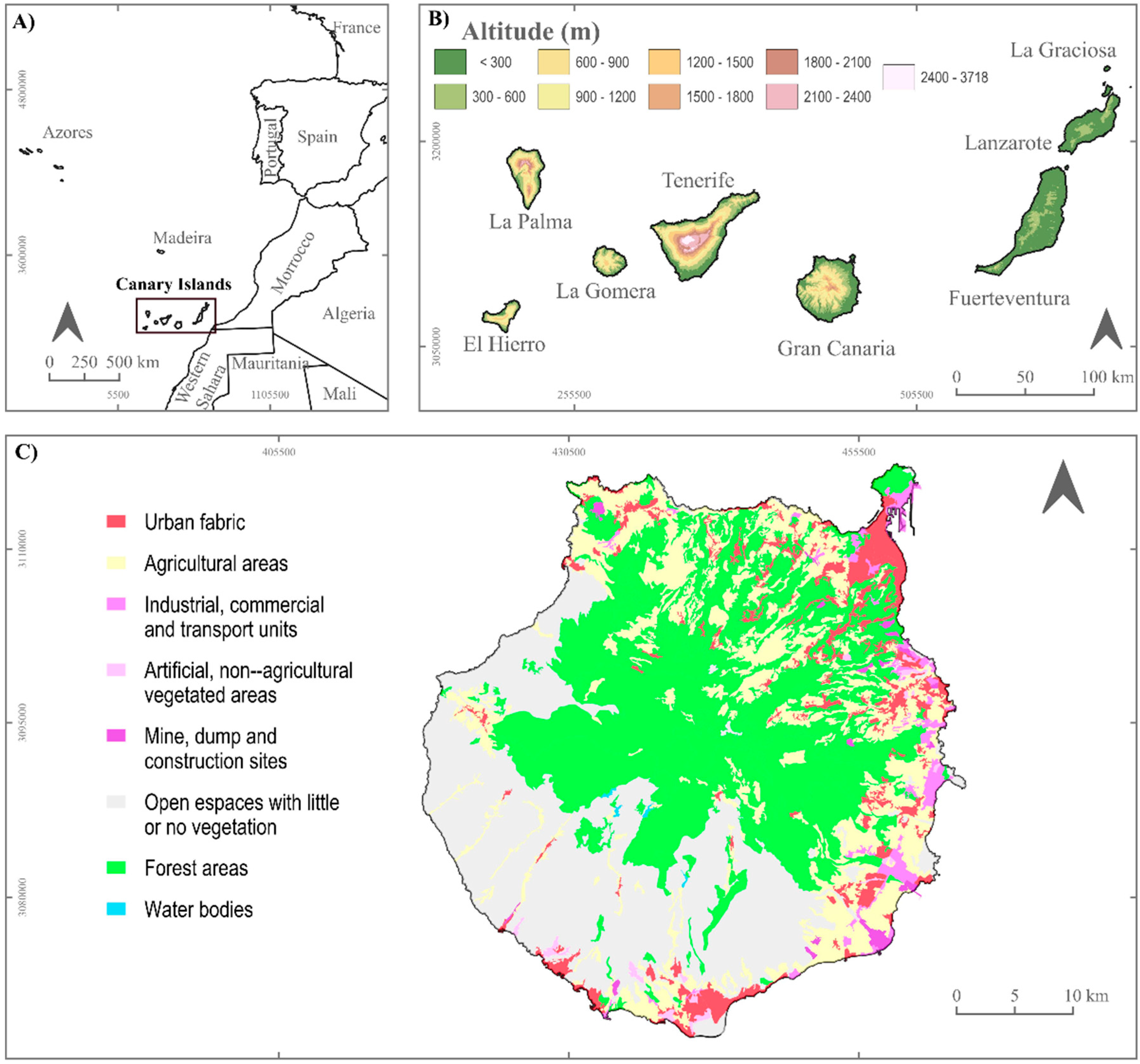
This study focuses on the island of Gran Canaria (GC), located in the Canary Islands archipelago (Figure 1). The Canary Islands constitute one of the 17 autonomous communities of Spain and are officially classified as an outermost region of the European Union. Gran Canaria is the fifth-largest island of the archipelago, with a surface area of 1560 km2, and reaches a maximum elevation of 1949 m above sea level.
Figure 1.
Geographic location and topographic features of the Canary Islands. (A) Location of the Canary Islands in the North Atlantic region. (B) Altitude distribution by island. (C) Land-use and land-cover types on the island of Gran Canaria. Source: Own elaboration based on GIS data from [4,18].
Climatic conditions on the island are strongly conditioned by topographic factors, particularly altitude and slope orientation, which generate marked spatial contrasts over short distances [19]. According to the Interactive Digital Climatic Atlas of the Canary Islands [20], mean annual air temperatures range from approximately 21.0–21.5 °C in coastal sectors oriented towards the south and southwest to values close to 12.5 °C in summit areas. Annual precipitation shows a highly uneven spatial distribution, with average values reaching around 730 mm in the headwaters of the main catchments, while extensive coastal areas and lower mid-altitude zones in the eastern, southern, and southwestern parts of the island record annual totals below 100 mm. These pronounced gradients in temperature and precipitation result in a high degree of climatic diversity across the island. According to the Köppen climate classification, dry climates (type B), characterized by annual precipitation lower than potential evapotranspiration, predominate in Gran Canaria [20]. In particular, hot desert (BWh) and steppe climates (BSh and BSk), differentiated by whether mean annual temperatures exceed or fall below 18 °C, occupy more than 70% of the island’s surface. Temperate climates (types Csa and Csb), defined by higher humidity levels and milder thermal conditions, are mainly restricted to mid-altitude areas and the highest elevations, covering approximately 30% of the island. The island exhibits an approximately circular shape, with a diameter of around 45 km, a dense radial network of deeply incised ravines and canyons, and a central mountainous core that strongly conditions both climatic dynamics and land-use patterns [21] The vascular flora of the Canary Islands includes a high number of endemic species, reflecting the archipelago’s geographic isolation and environmental diversity. In Gran Canaria, different vegetation communities can be distinguished according to altitude and exposure, including coastal shrublands, thermophilous forests, laurel forest (monteverde), pine forests, and high-altitude shrublands. A significant portion of the island is protected under various conservation designations, and approximately 40% of Gran Canaria form part of the Gran Canaria Biosphere Reserve, comprising 33 different categories of protected areas.
After Tenerife, Gran Canaria is the second-most populated island of the archipelago, with approximately 875,200 inhabitants in 2024 [22]. Population density on Gran Canaria is particularly high compared to the Spanish average, reaching values close to 543 inhabitants per km2 [22]. The population is mainly concentrated in coastal areas, where the island capital is located, while the mountainous interior has experienced processes of depopulation and abandonment of traditional land uses. This territorial pattern generates a marked contrast between densely urbanized coastal zones and interior areas characterized by high vegetation continuity. From a socioeconomic perspective, the Canary Islands rank eighth among Spanish regions in terms of GDP, although they present high unemployment rates and per capita income levels below the national average [22]. In Gran Canaria, one of the main drivers of economic development is tourism [23,24], particularly the sun-and-beach type concentrated in the southern part of the island. This activity has significantly stimulated the construction sector and has strongly influenced urban expansion along the coast. Agriculture continues to play a relevant role in certain rural areas of the island, although its importance is markedly lower than in previous decades. The most significant crops include irrigated banana plantations and greenhouse tomato production for export, shaping highly specialized agricultural landscapes with a strong dependence on water resources.
2.2. Study Design
This research is based on a mixed-methods approach combining documentary analysis, territorial assessment, and case-study methodology to characterize the evolution of wildfire risk on the island of Gran Canaria between 2000 and 2020. The study design integrates (i) the compilation and statistical analysis of quantitative information on wildfire frequency, burned area, severity indicators, and spatial distribution, including trend and concentration analyses; and (ii) a qualitative analysis of climatic, socio-territorial, and governance-related factors influencing wildfire risk, particularly in the (WUI). The qualitative component is designed as a structured documentary review and directed content analysis, aimed at supporting the interpretation of statistical results rather than generating independent causal inference.
2.3. Information Sources
Three main categories of sources were used (Table 1).
Table 1.
Classification of sources used in the study.
These sources were selected for their direct relevance to the phenomenon under study and because they constitute validated documentation produced by public agencies responsible for risk management, ensuring methodological credibility.
2.4. Case Studies
To assess the occurrence and impact of extreme events, three representative large wildfires (Table 2) were selected as case studies, based on the following criteria:
Table 2.
Large wildfires selected as case studies in Gran Canaria (2007–2020).
- Burned area ≥ 500 ha.
- Declaration of emergency involving evacuation procedures.
- Significant impact on WUI areas.
- Availability of verifiable technical documentation.
This selection allows the observation of propagation patterns, territorial impacts, and operational responses under extreme climatic conditions.
2.5. Analysis Procedure
The analysis was structured into four complementary phases aimed at characterizing the evolution of wildfire risk in Gran Canaria from statistical, climatic, territorial, and institutional perspectives.
In the first phase, a statistical characterization of wildfires recorded between 2000 and 2020 was conducted using annual time series of wildfire frequency, total burned area, and event size. The statistical analyses were limited to the 2000–2020 period because this interval corresponds to officially verified and internally consistent wildfire records. Post-2020 data are not yet consolidated under the same validation protocol and were therefore excluded to ensure time-series comparability.
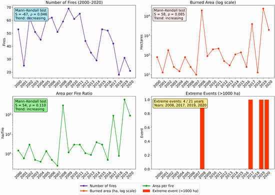
In a second phase, wildfire activity and severity were assessed using time-series indicators derived from official fire records. These included (i) the annual number of wildfires; (ii) the total burned area per year; and (iii) the burned area per fire ratio, used as an indicator of average wildfire impact. In addition, years with extreme wildfire events were identified based on fires exceeding 1000 ha. Burned area concentration was further evaluated using wildfire percentiles and the Gini coefficient. Temporal trends in all wildfire-related series were analyzed using the non-parametric Mann–Kendall test.
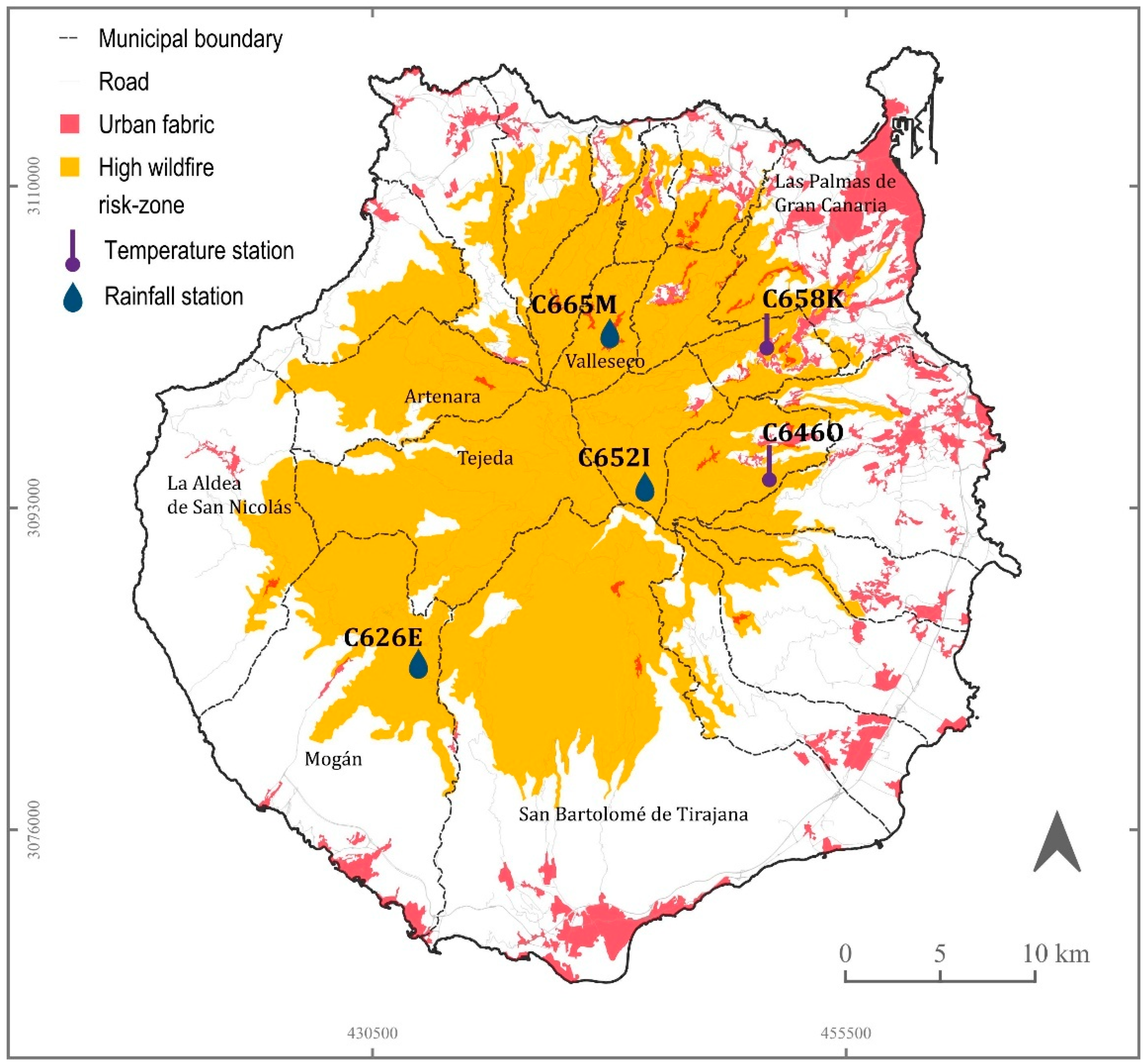
In the third phase, annual time series of climatic variables were constructed, including the number of days with temperatures exceeding 30 °C and precipitation-related variables. Climatic influences on wildfire activity were examined through trend analysis and descriptive comparison with wildfire occurrence, focusing on long-term changes in thermal conditions and moisture availability rather than short-term causal relationships. Meteorological data were selected from stations located within the High Wildfire Risk Zones (ZARI) defined in island-level planning instruments (Figure 2), ensuring spatial consistency between climatic conditions and wildfire occurrence. Three daily precipitation series were selected as representative of the main island orientations: one located on the northern slope (C665M), one on the southwestern slope (C626E), and one in the central sector of the island (C652I). All three series present complete records and belong to the rain-gauge network of the Spanish State Meteorological Agency (AEMET, Madrid, Spain) for the period 1991–2020 (Table 3). In addition, the analysis of extreme temperatures (defined as daily maximum temperatures exceeding 30 °C) was based on two daily maximum temperature series covering the same period (1991–2020): one located on the eastern slope of the island (C646O) and another on the northeastern slope (C658K). As noted by [24], one of the main limitations in the analysis of air temperature in Gran Canaria is the scarcity of long and continuous instrumental records. In this study, the stations with the most complete and continuous data availability for the 1991–2020 period were selected. Nevertheless, some data gaps remain. Station C646O begins in August 1994 and lacks records for May and August 2004, December 2008, January 2015, January 2019, and April and May 2020. Station C658K starts in January 1991 and lacks records for August 1999, September 2007, November 2008, and April 2018. For this reason, station C646O was selected as the primary reference for daily maximum temperature analysis, given its greater data availability and temporal continuity.
Figure 2.
Spatial distribution of ZARI, urban areas, and meteorological stations in Gran Canaria. Source: SITCAN (Canary Islands Territorial Information System, Las Palmas, Spain) [18]. Own elaboration.
Table 3.
Selected meteorological stations in Gran Canaria (1991–2020).
In addition to biophysical drivers, wildfire risk was further examined from a territorial and institutional perspective. Finally, territorial and exposure factors were analyzed, considering wildfire risk as a socio-ecological construct influenced by environmental conditions and land-use patterns. Key processes reviewed included rural abandonment, expansion of the (WUI), forest regrowth, and the evolution of wildfire prevention and emergency management policies. This phase was based on a structured documentary review and directed content analysis of official planning instruments, emergency regulations, technical reports, and institutional documentation. Documents were screened and interpreted using predefined analytical categories (territorial exposure, land-use change, WUI dynamics, and governance evolution) to ensure methodological transparency.
3. Results
3.1. Statistical Evolution of Wildfires (2000–2020)
The analysis of the distribution of burned areas reveals a strong concentration of spatial impact in a very limited number of wildfire events (Figure 3). Results show that the largest wildfire recorded in 2019 accounts for 45.6% of the total burned area over the entire study period. In addition, the three largest wildfires together represent 97.6% of the cumulative burned area, while only four wildfires exceeding 1000 ha, corresponding to 0.4% of the 988 recorded events, account for nearly the entire affected area (Table 4). Temporal trends in wildfire frequency and burned area were statistically validated using the Mann–Kendall test (Table 5).
Figure 3.
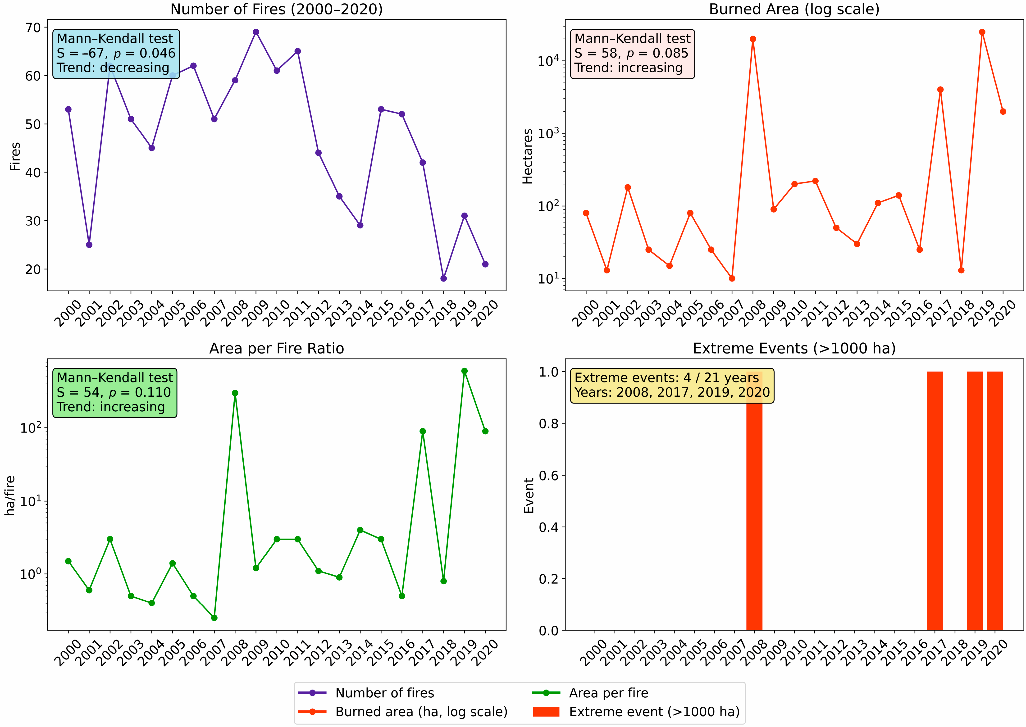
Temporal evolution of wildfire frequency, burned area, and extreme events in Gran Canaria (2000–2020). Complete time series showing (left-upper) annual number of wildfires, (right-upper) total burned area (log scale), (left-lower) burned area per fire, and (right-lower) years of extreme wildfire events (>1000 ha burned). Mann–Kendall trend test results are reported for each time series.
Table 4.
Concentration of burned area by wildfire percentiles (2000–2020).
Table 5.
Statistical validation. Mann–Kendall trend tests using the complete dataset.
This pronounced inequality in the distribution of spatial impact is reflected in a Gini coefficient of 0.867, indicating an extremely skewed distribution of burned area among wildfire events. This extreme concentration confirms that a very small fraction of wildfires accounts for the majority of the burned area during the study period, evidencing a “few events, most of the area” pattern.
The island’s wildfire risk does not depend on the number of fires, but on the increasing likelihood of LFWs occurring under critical meteorological conditions. The island’s wildfire risk is not driven by the number of ignitions, but by the probability that a small number of LFWs occur under critical climatic and territorial conditions.
3.2. Characterization of Extreme Wildfires and Territorial Exposure
The analysis of large wildfires recorded in Gran Canaria between 2007 and 2020 allows for a detailed description of four high-impact events that occurred under particularly adverse environmental and territorial conditions. These events illustrate situations in which extreme meteorological conditions, accumulated fuel loads, and high exposure of population and infrastructure located in the WUI coincided.
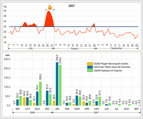
The first of these episodes, occurring in 2007, affected areas in the southwest of the island, mainly the municipalities of Tejeda, San Bartolomé de Tirajana, Mogán, and La Aldea de San Nicolás. Burning approximately 18,684 hectares, it is the largest wildfire ever recorded in the Canary Islands, leading to the evacuation of nearly 4000 people and requiring 17 days to achieve control. The combination of extreme temperatures and strong winds favored rapid spread and significantly hindered suppression [26] The observed maximum temperature data recorded at meteorological station C646O during July show values exceeding 30 °C from 9 July to 20 July and again from 26 July to 1 August. Therefore, highly favorable conditions existed for the development of LFWs, which ignited on 27 July, when the maximum temperature recorded at this station reached 37.5 °C. Temperatures exceeded 40 °C on 28 July, 29 July and 30 July (Figure 4). These conditions were further exacerbated by very low precipitation during the autumn of 2006 and the winter of 2007, totaling only 127.8 mm, making 2007 one of the driest years in the analyzed series.
Figure 4.
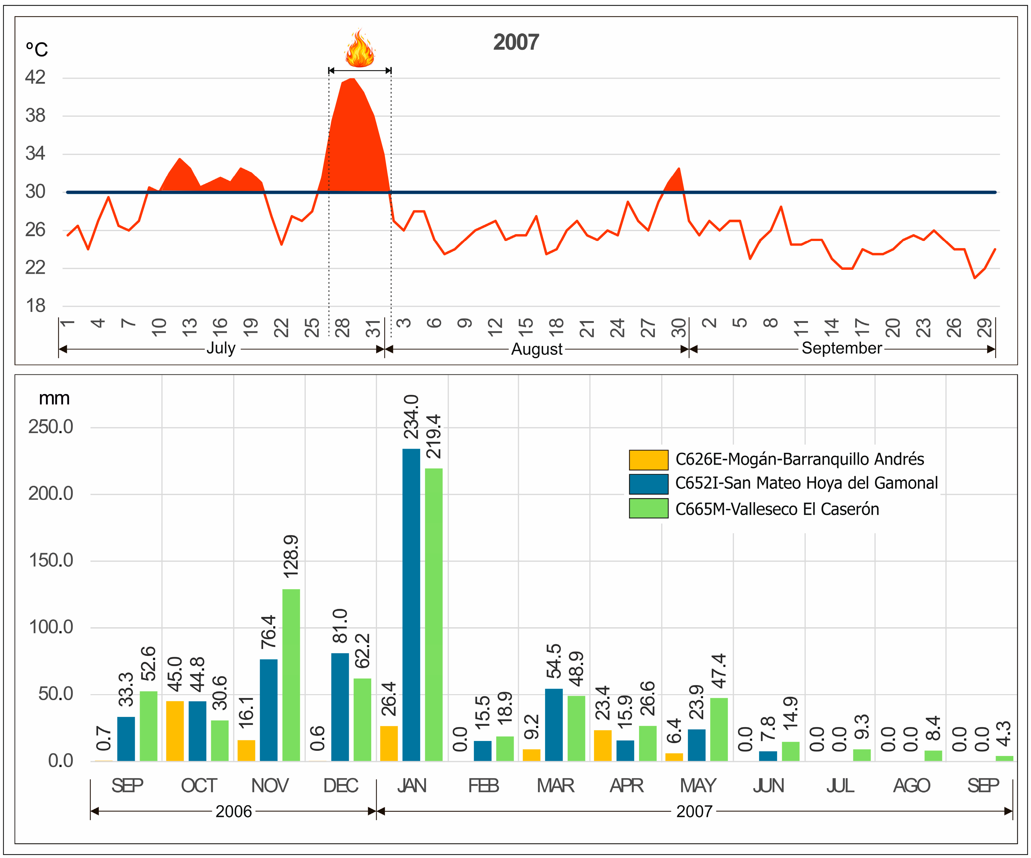
Meteorological conditions during the 2007 extreme wildfire event in Gran Canaria. The upper panel shows the daily maximum air temperature (°C) recorded at station C646O between July and September 2007; the horizontal line indicates the 30 °C threshold, and the fire symbol marks the start and end dates of the large wildfire that year. The lower panel shows monthly precipitation totals (mm) recorded at stations C626E, C652I, and C665M between September 2006 and September 2007.
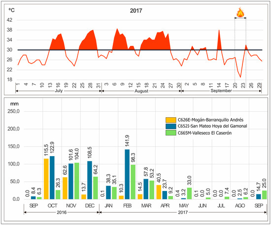
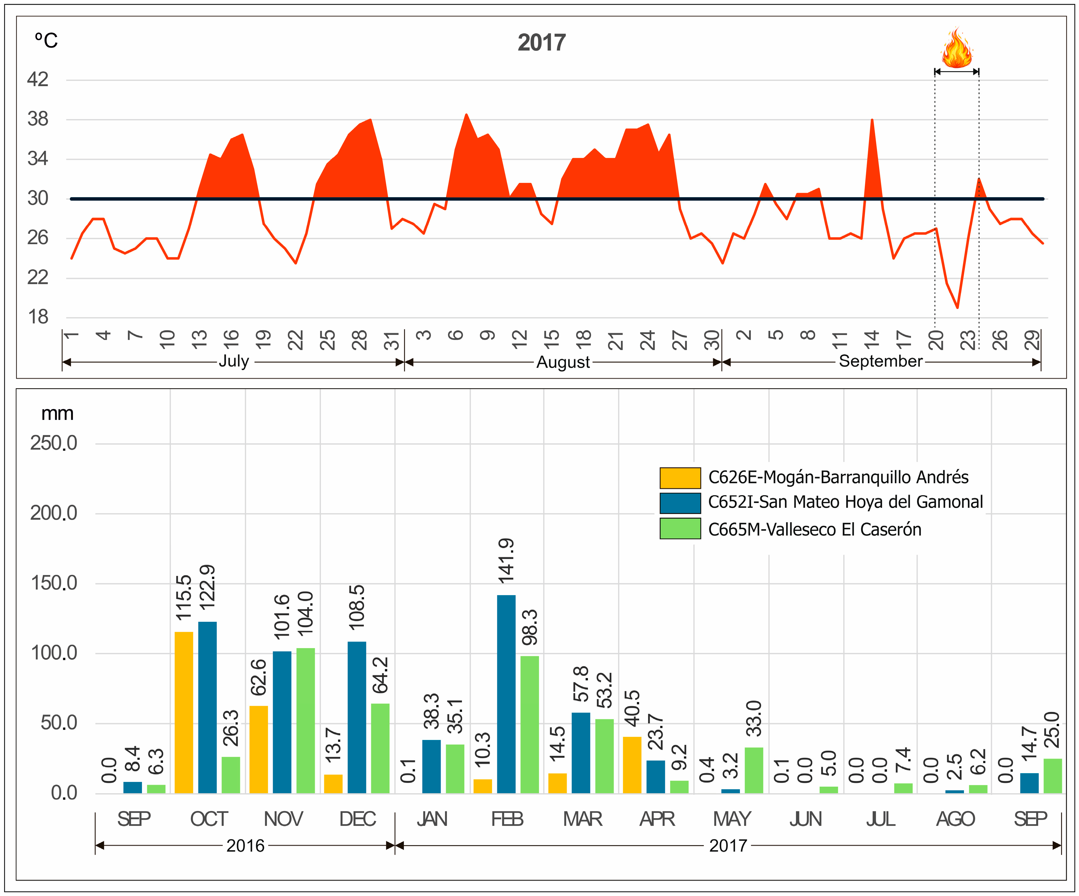
A decade later, in 2017, a smaller wildfire occurred, though it was particularly relevant in terms of social and territorial impact. This event, located in the central highlands around Cruz de Tejeda, burned approximately 1893 hectares and forced the evacuation of around 400 people. Its main significance lies in its direct impact on WUI areas, highlighting the vulnerability of inhabited rural settings where residential structures are embedded within forested landscapes. Daily maximum temperature values in September do not show extremes comparable to those observed during the July 2007 wildfire, as only four days with temperatures exceeding 30 °C were recorded at station C646O. However, meteorological conditions in the preceding period were characterized by persistent advection of continental tropical air from the Sahara Desert throughout August, with 19 days exceeding 30 °C and a maximum temperature of 37.5 °C recorded on 24 August (Figure 5). These conditions were further compounded by pronounced vegetation dryness resulting from the absence of precipitation during 2017, which ranked as the second driest year in the C626E series, with a total annual precipitation of only 68.4 mm.
Figure 5.
Meteorological conditions during the 2017 wildfire event in central Gran Canaria. The upper panel shows the daily maximum air temperature (°C) recorded at station C646O between July and September 2017; the horizontal line indicates the 30 °C threshold, and the fire symbol marks the start and end dates of the large wildfire that year. The lower panel shows monthly precipitation totals (mm) recorded at stations C626E, C652I, and C665M between September 2016 and September 2017.
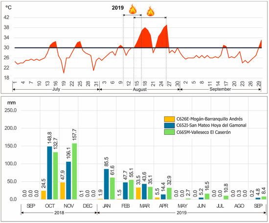
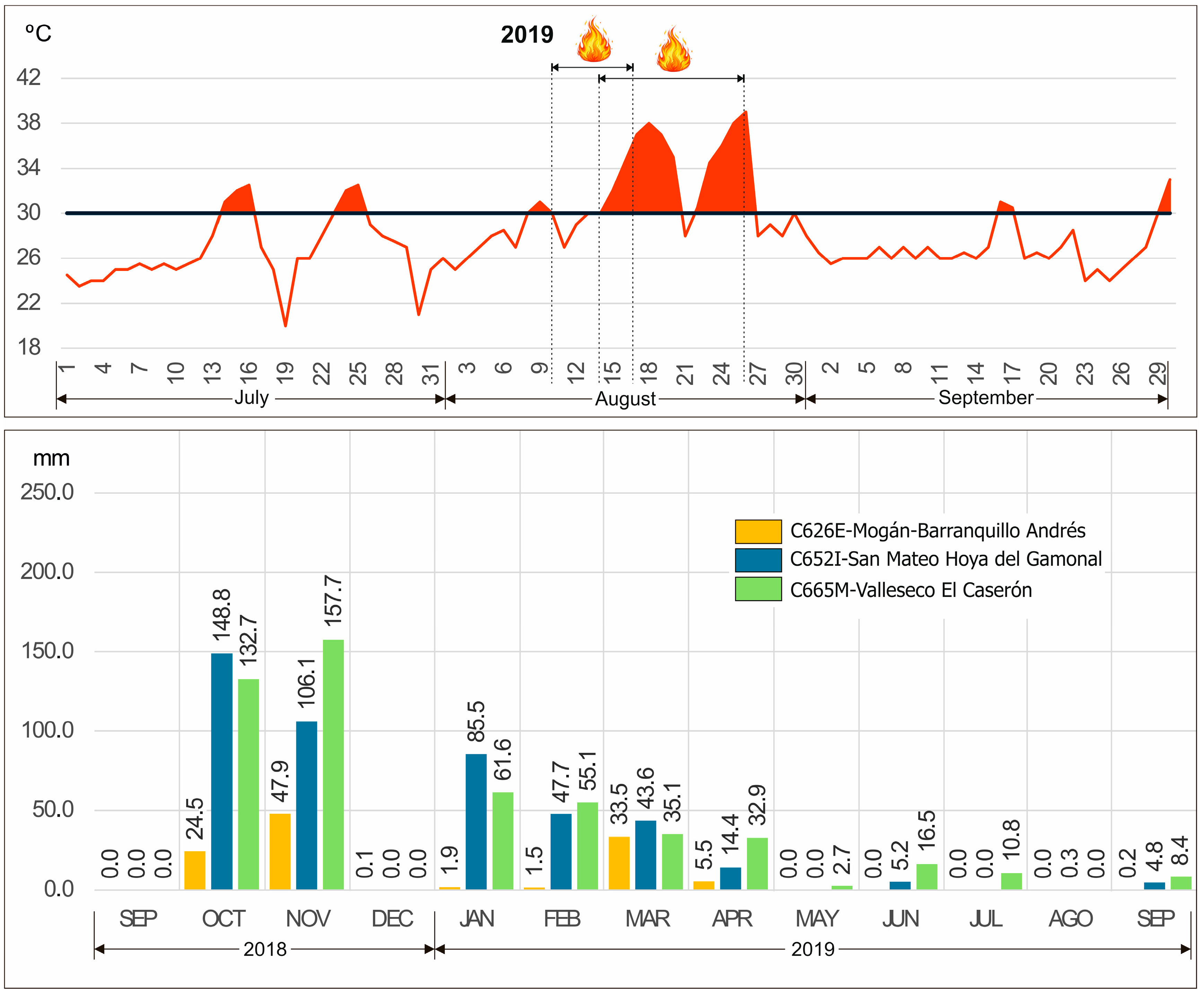
The third case corresponds to the consecutive wildfires of Artenara and Valleseco during the summer of 2019. Together, they represented two phases of the same critical episode, affecting a combined area of nearly 10,700 hectares. More than 10,000 people were evacuated, making it the largest human displacement caused by wildfire in the history of the Canary Islands. These fires also significantly affected protected natural areas and zones previously identified as ZARI (Figure 2). From July onwards, very high air temperature values were recorded, with six days exceeding 30 °C. However, the conditions observed during August were particularly conducive to the development of this wildfire, as the temperature exceeded 30 °C on a total of 18 days between 8 August and 30 August, with a maximum temperature of 39 °C recorded on 26 August (Figure 6). It should also be noted that 2019 was the driest year in the C626E station record, with a total annual precipitation of only 56.4 mm. Furthermore, between September 2018 and April 2019, cumulative precipitation amounted to just 114.9 mm, reinforcing the presence of extreme antecedent dryness of vegetation fuels in the island’s forested areas.
Figure 6.
Meteorological conditions during the 2019 Artenara–Valleseco wildfire episode in Gran Canaria. The upper panel shows the daily maximum air temperature (°C) recorded at station C646O between July and September 2019; the horizontal line indicates the 30 °C threshold, and the fire symbol marks the start and end dates of the large wildfire that year. The lower panel shows monthly precipitation totals (mm) recorded at stations C626E, C652I, and C665M between September 2018 and September 2019.
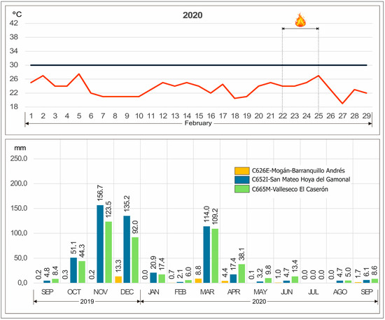
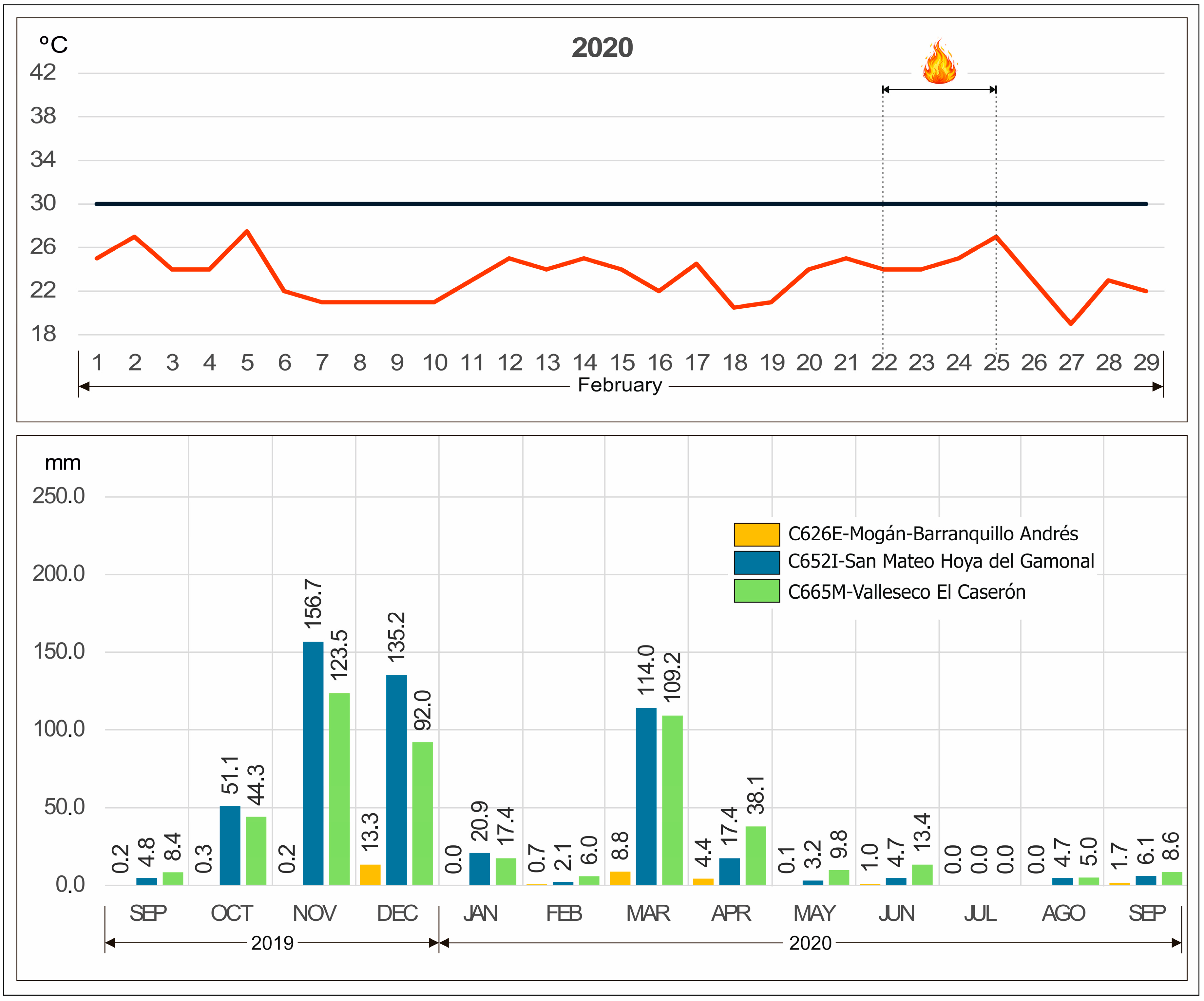
Finally, the February 2020 wildfire exhibits a climatic pattern distinct from the summer events of 2007 and 2019, yet equally conducive to the development of a large wildfire. Although daily maximum temperature values recorded at station C646O during January and February 2020 did not reach the extreme summer thresholds (>30 °C), anomalously high values for the winter season were observed, with maximum temperatures reaching 27.5 °C in February. These conditions are consistent with the occurrence of continental Saharan air advection episodes (calima) affecting the island during this period. Particularly relevant is the fact that these winter thermal anomalies occurred under conditions of pronounced antecedent dryness. Between September 2019 and February 2020, only 14.7 mm of precipitation were recorded at station C626E, resulting in unusually dry fuel availability for the season (Figure 7). The combination of winter thermal anomalies, low atmospheric humidity, and cumulative moisture deficit created favorable conditions for the ignition and spread of a large wildfire between 22 and 25 February 2020, despite the absence of extreme summer temperatures.
Figure 7.
Meteorological conditions during the February 2020 winter wildfire in Gran Canaria. The upper panel shows the daily maximum air temperature (°C) recorded at station C646O in February 2020; the horizontal line indicates the 30 °C threshold, and the fire symbol marks the start and end dates of the large wildfire that year. The lower panel shows monthly precipitation totals (mm) recorded at stations C626E, C652I, and C665M between September 2019 and September 2020.
Although limited in number, these four events share several common characteristics, including their occurrence under extreme meteorological conditions, the presence of continuous and highly accumulated fuel loads, and a strong interaction with exposed population and infrastructure in WUI areas. Rather than defining a statistically representative pattern, these case studies illustrate the types of conditions under which the most severe wildfire impacts have occurred on the island.
3.3. Influence of Climate Variability and Warming Trends on the Fire Regime
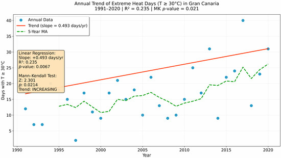
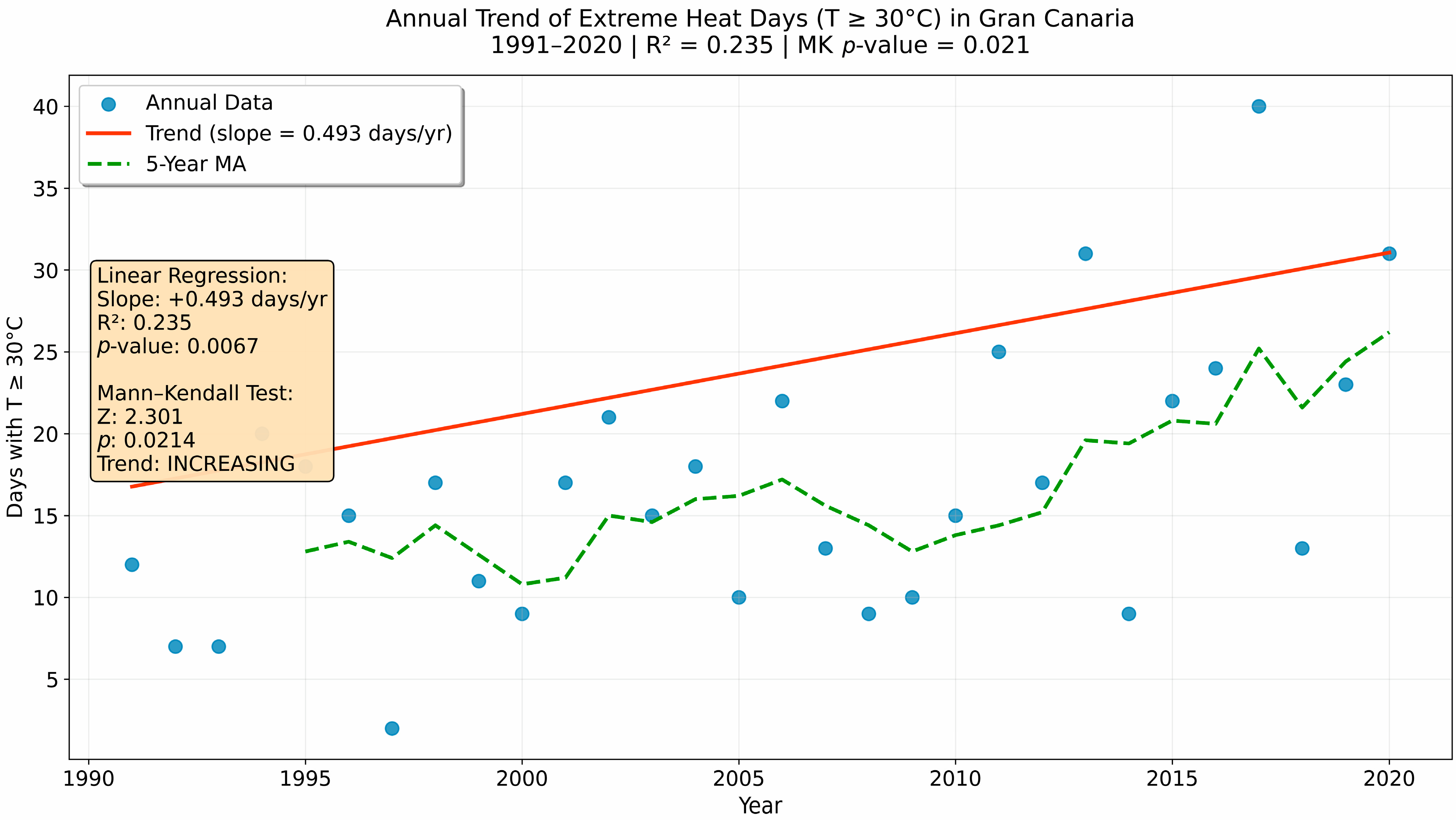
The influence of climatic conditions on the recent wildfire regime in Gran Canaria was assessed through the analysis of long-term meteorological indicators, focusing on the annual number of extreme heat days (T ≥ 30 °C) for the period 1991–2020. This variable was selected as a proxy for atmospheric conditions conducive to fuel desiccation and the development of more severe fire behavior. The time series of extreme heat days exhibits a statistically significant positive trend over the study period. Linear regression analysis indicates a slope of +0.493 days·year−1 (R2 = 0.235; p = 0.0067), evidencing a progressive increase in the annual frequency of days with T ≥ 30 °C (Figure 8). On average, this represents nearly half an additional extreme heat day per year, resulting in a substantial cumulative change over the last three decades. Although the coefficient of determination is moderate, reflecting the high interannual variability characteristic of insular climates, it does not undermine the statistical significance of the observed trend. The robustness of this result is further confirmed by the Mann–Kendall non-parametric test, which also identifies a significant increasing trend (Z-statistic = 2.301; p = 0.0214), reinforcing the evidence of a sustained rise in extreme thermal conditions.
Figure 8.
Annual trend of extreme heat days (T ≥ 30 °C) in Gran Canaria for the period 1991–2020. Linear regression results indicate a coefficient of determination of R2 = 0.235, while the Mann–Kendall test confirms a statistically significant increasing trend (p = 0.021).
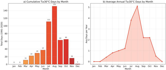
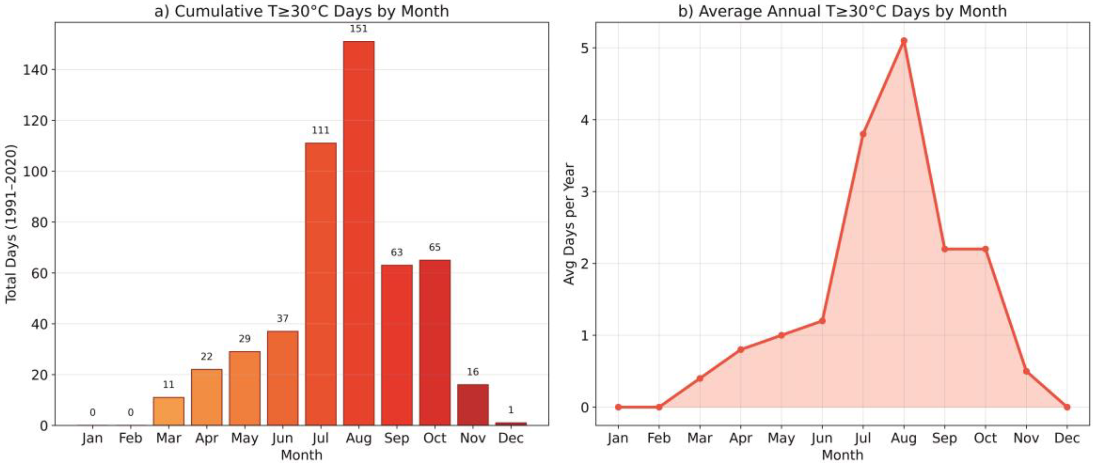
From an intra-annual perspective, extreme heat days show a marked seasonal pattern, with a strong concentration during the summer months, particularly July and August, which account for the highest cumulative and mean annual values (Figure 9). Nevertheless, the occurrence of T ≥ 30 °C days outside the traditional summer period suggests an extension of thermally favorable conditions beyond the classical wildfire season.
Figure 9.
Monthly distribution of extreme heat days (T ≥ 30 °C) in Gran Canaria for the period 1991–2020: (a) total number of extreme heat days by month (cumulative), and (b) mean annual number of extreme heat days per month.
Within the analyzed series, several climatically extreme years stand out, notably 2012, 2013, and the period 2015–2020, with 2017 recording the historical maximum of 46 days with T ≥ 30 °C. This year coincides with one of the most severe wildfire events documented on the island, suggesting that exceptionally high frequencies of extreme heat days may act as an amplifying factor of wildfire severity when combined with other territorial and anthropogenic drivers.
3.4. Land-Use Planning and the Increasing Risk in the Wildland–Urban Interface (WUI)
The results show that wildfire hazard in Gran Canaria is not determined solely by climatic conditions but is deeply linked to socioeconomic processes and land-use change. The progressive abandonment of agricultural and forestry activities has led to a substantial accumulation of vegetation fuels, generating continuous and homogeneous landscapes that facilitate large-scale fire propagation. Areas that once hosted croplands, pastures, or productive spaces—functioning as natural discontinuity belts—are now dominated by dense, unmanaged vegetation, increasing territorial flammability. At the same time, the irregular expansion of dispersed housing on rural land—often in direct contact with forested areas—has increased not only the probability of ignition but also the direct exposure of the population to wildfire impacts. This land-use pattern creates highly complex operational scenarios in which mass evacuations become major logistical challenges due to limited access routes, vulnerable infrastructure, and fragmented road networks. The increasing influx of urban populations into rural and natural areas for recreational purposes—often unfamiliar with rural fire-safe practices—constitutes another significant factor. This trend raises the likelihood of human negligence, which accounts for nearly 70% of recent ignitions recorded on the island. Finally, the expansion of forest cover, driven by natural recolonization of abandoned land and reforestation programs, has intensified continuous fuel loads within the WUI, amplifying risk in areas where human settlements come into direct contact with highly flammable ecosystems.
Taken together, these processes demonstrate that wildfire risk in Gran Canaria is not only climatic but also territorial and social, directly related to how the landscape is inhabited, used, and—above all—managed. The current vulnerability of the territory stems not from fire alone but from the interaction between settlement patterns, productive abandonment, and the lack of preventive land-use planning, particularly in rural land and natural areas.
Legislative changes to the territorial planning framework have accumulated over recent decades, evolving from the first regional land-use planning law of 1999 [27] to the landmark Law 4/2017 on Land and Protected Natural Areas of the Canary Islands [28], followed by successive partial amendments up to 2023, including Royal Decree 445/2023 aimed at strengthening environmental protection. This regulatory corpus establishes principles and directives enabling land-use planning instruments to adjust municipal development models according to their environmental characteristics, following prior diagnosis and evaluation of planning proposals.
In theory, the framework aligns with the need to identify risk areas and determine suitable spaces for different land uses according to their carrying capacity. However, for this to materialize, it is necessary to accelerate the processing and updating of planning instruments (Table 6), as without them it is impossible to prevent many of the conditions identified as drivers of increased large wildfire LFWs risk.
Table 6.
Classification and number of territorial planning instruments according to their regulatory framework in the Canary Islands.
The regulation of land uses in rural and natural areas—especially the allocation of resources for the management of these spaces and the effective enforcement of existing regulations—is essential. However, the continued expansion of dispersed housing, including within forest areas where such development is explicitly prohibited, persists despite attempts to classify such dwellings as non-conforming building and halt this type of construction. This situation is reinforced by the state of the planning system: an analysis reveals that only about 9% of municipal plans have been updated in the last 12 years, since the entry into force of Law 21/2013 on Environmental Assessment [31]. The vast majority of municipal plans are therefore outdated and unable to address contemporary wildfire risks. This planning inertia likely reflects a combination of factors, including the procedural and technical complexity of revising planning instruments under successive regulatory reforms, limited financial and technical capacity at the municipal level, and political or land-use conflicts where stricter regulation may affect dispersed housing in rural and forested areas. These elements generate institutional inertia, delaying the incorporation of wildfire risk into enforceable land-use regulation.
3.5. Strengthening Public Policies: From Emergency Response to Resilience
The period 2000–2020 reflects a progressive transformation in wildfire management strategies in Gran Canaria, marked by a shift from a predominantly reactive approach—focused on suppression—toward a preventive governance model oriented toward territorial resilience. This shift involves understanding fire as an inevitable and recurrent phenomenon in island ecosystems, while recognizing that its impact can be reduced through planned interventions on the landscape and on human occupation in exposed areas. In this context, the updated emergency regulations have incorporated, for the first time, an explicit focus on the WUI, establishing specific obligations for homes located in risk zones, such as the requirement to maintain a minimum 15 m self-protection perimeter free of combustible vegetation. In parallel, a mosaic-landscape model has been promoted, based on preventive tools such as targeted grazing, prescribed burning, and selective thinning, with the aim of reducing fuel continuity and limiting the spread of high-intensity wildfires. All these obligations must be integrated into the regulatory framework of Territorial Plans and General Urban Development Plans, as their effective implementation requires direct enforcement mechanisms through urban planning competences—specifically, municipal permitting authorities and, for disciplinary matters, the Urban and Natural Environment Protection Agency.
Alongside these territorial measures, the island has incorporated specialized WUI firefighting units, representing a qualitative leap in operational capacity through brigades trained for interventions in inhabited areas, where fire assumes a critical social dimension. At the same time, the implementation of simulation and spatial-analysis systems using GIS technologies—such as the ALERTAGRAN program (Cabildo de Gran Canaria, Las Palmas, Spain)—has strengthened real-time tactical decision-making, enabling the anticipation of fire spread routes, the prioritization of resources, and more efficient evacuation planning [32].
Taken together, this process of institutional change represents a conceptual shift: from “firefighting” to managing the territory so that it does not burn. Prevention, landscape planning, and shared citizen responsibility emerge as fundamental pillars of resilience to wildfire in regions increasingly subjected to extreme events and growing climatic pressure.
4. Discussion
The results reveal a profound transformation in the wildfire regime of Gran Canaria over the past two decades. Although the frequency of ignitions has decreased compared to previous periods, the impact associated with wildfires has increased dramatically due to the concentration of burned areas in a small number of extreme events. This finding challenges the widespread use of ignition counts as a primary wildfire risk metric and underscores the need to prioritize severity- and impact-based indicators, particularly in WUI-dominated regions. This pattern shifts the focus towards a qualitative analysis of severity rather than merely quantifying the number of fires—a phenomenon that aligns with the transition toward risk scenarios dominated by increasingly extreme climatic conditions [33,34] This concentration is further supported by inequality measures derived from the wildfire size distribution. The Gini coefficient reaches a value of 0.867, indicating a level of inequality very close to perfect concentration. This result highlights an extremely skewed distribution of burned areas, in which a very limited number of wildfire events concentrates nearly the entire spatial impact. From an interpretative perspective, this high degree of concentration confirms that the wildfire regime in Gran Canaria is dominated by rare but very large events, while the majority of fires produce only limited territorial impacts. In this context, the four extreme wildfires exceeding 1000 ha represent just 0.4% of all recorded events, yet account for 97.6% of the total burned area.
The historical seasonality of wildfire risk—traditionally associated with the summer months—has ceased to be a valid reference [33,34] The increase in heatwaves, the decline in relative humidity, reduced precipitation, and the occurrence of anomalous meteorological episodes linked to Saharan dust intrusions have all expanded the fire hazard period, transforming it into an almost year-round phenomenon [5]. In this context, the climatic analysis conducted in this study indicates that recent wildfire dynamics in Gran Canaria cannot be attributed to a single dominant meteorological variable through direct statistical relationship [9]. Instead, the results highlight a progressive transformation of the background climatic conditions under which wildfires develop. The statistically significant increase in the frequency of extreme heat days (T ≥ 30 °C) reflects a long-term warming trend that enhances fuel desiccation and extends the temporal window of potential fire activity. While correlation analyses between annual wildfire indicators and climatic variables show generally weak associations, these results do not diminish the role of climate as a structural driver of wildfire risk. Rather, they suggest that climatic forcing operates by increasing the predisposition of the territory to extreme fire behavior, acting in combination with fuel accumulation, land-use change, and ignition patterns. Under this framework, climate change does not function as a short-term predictor of wildfire occurrence, but as a persistent conditioning factor that amplifies the likelihood and severity of large wildfire events. Consequently, the classical concept of a clearly defined “wildfire season” becomes increasingly blurred, giving way to a regime in which extreme meteorological conditions—particularly prolonged periods of elevated temperatures—contribute to an almost continuous state of heightened fire risk.
However, risk cannot be explained solely through climatic dynamics. The territorial structure of Gran Canaria acts as a hazard multiplier, especially in the WUI. The expansion of dispersed housing in forest areas, the abandonment of traditional agricultural and silvicultural practices, and the natural regeneration of forest stands have significantly increased fuel loads and vegetation continuity [35] Where a productive mosaic of pastures, croplands, and forest-use areas once existed, there is now a continuous landscape of dense vegetation capable of sustaining high-intensity wildfires. This transformation has been gradual but decisive for understanding the virulence of recent fires [36].
A further structural element must be added: the lack of updated and effectively implemented land-use planning. Regulation of land uses in rural and natural areas—along with the allocation of resources needed to manage these spaces—remains insufficient, and the capacity to enforce existing regulations is severely constrained (Table 6). The occupation of the territory through dispersed housing, even within forest areas where such development is explicitly prohibited, continues despite attempts to classify such dwellings as non-conforming buildings or halt new construction [37].
This situation largely explains one of the factors driving the accelerated increase in wildfire risk. Without updated planning, it is impossible to properly manage land uses. This becomes even more urgent in highly fragile environments, where human activities require strict regulation, close monitoring, and effective enforcement due to the high ecological cost of even minor negligence [17,37].
The causes underlying the current situation of spatial planning are complex and cannot be attributed to a single factor. Rather, they can only be explained through the conjunction of several elements. First, there is the procedural, technical, and temporal complexity associated with the drafting and revision of planning instruments, particularly within a context marked by successive legislative reforms. Second, there are the financial costs that such efforts entail for local administrations, even when regional funding specifically allocated for this purpose is available. Third—and from a political perspective, seemingly the most decisive factor, although no concrete data can be provided to substantiate this claim beyond the observation of the behavior of different administrations over the past decade—is the requirement inherent in planning to anticipate future needs and to establish the basic lines of action for territorial development. This exercise in foresight, which becomes consolidated or even rigidified through a planning instrument, subjects territorial decision-making to a constraining framework that is not always compatible with governing bodies whose expectations of intervention are limited to a single political term, often shorter than the time required for the processing and implementation of planning determinations. All of this leads to a reluctance to initiate territorial and urban planning procedures, as the absence of an approved plan generally allows for greater managerial flexibility and, therefore, greater adaptability to the will of those responsible for decision-making in this field.
In this context, wildfires are no longer solely ecological phenomena; they are also social and territorial. Human presence in forest areas has simultaneously increased the number of negligence-related ignitions and the vulnerability of the exposed population. The evacuation of more than 10,000 people during the 2019 wildfire not only reflects the danger of fire but also highlights the logistical challenge posed by numerous and dispersed settlements with limited access routes and structures highly exposed to rapid spread. Wildfire risk in Gran Canaria, therefore, depends not only on fire behavior but also on how the territory is inhabited and managed.
Given this reality, the recent institutional shift toward prevention, planning, and landscape management strategies becomes particularly relevant. Emerging policies promote innovative approaches such as mandatory self-protection measures around homes, the use of technical fire, grazing as a preventive tool, and the design of mosaic landscapes. Additionally, the incorporation of real-time simulation and spatial analysis systems—such as ALERTAGRAN—reflects a transition toward governance based on technology and anticipation [32,38]. These measures represent a paradigm shift: the objective is no longer only to extinguish fires but to create less flammable territories and better prepared communities.
Nevertheless, a key challenge persists in terms of updating urban planning regulations with respect to WUI areas. The capacity to build resilient landscapes will remain limited if new housing continues to be developed in high-risk zones without strict planning or fire-adapted design criteria. Future resilience will depend as much on urban planning as on forest management. In essence, Gran Canaria illustrates an ongoing adaptation process, while also demonstrating that effective risk governance requires the integration of environmental, territorial, and social policies.
5. Conclusions
The evolution of the wildfire regime in Gran Canaria over the past two decades reveals a structural transformation marked by the increasing severity of events and the progressive loss of risk seasonality. This transformation is quantitatively supported by the statistical analysis, which confirms a statistically significant decreasing trend in wildfire frequency over the study period alongside an extreme concentration of burned areas in a very limited number of large events. The decrease in the total number of fires does not imply a reduction in danger; on the contrary, the concentration of burned areas in a small number of large wildfires—often occurring under extreme meteorological conditions—indicates a future scenario dominated by high-intensity events with significant socio-environmental impacts. In this context, wildfire risk is increasingly driven by severity rather than frequency, reinforcing the relevance of impact-based and territorial indicators over simple ignition counts. This change cannot be understood solely from a climatic perspective. While the climatic analysis highlights the role of annual precipitation in shaping fuel moisture conditions, the results also indicate that climatic forcing alone is insufficient to explain the observed impacts. The results demonstrate that the territory acts as a risk amplifier when three key factors converge: the abandonment of traditional agroforestry uses, increased continuity of vegetation fuel, and the expansion of dispersed housing in wildland–urban interface (WUI) areas. Thus, wildfire risk is a social construct associated with how the landscape is inhabited, managed, and transformed. A large wildfire is both an ecological phenomenon and the consequence of insufficient, outdated, or unenforced territorial and urban planning.
In response, public policies in Gran Canaria have initiated a transition toward a more preventive and territorially grounded governance model in civil protection and emergency management. The implementation of mandatory self-protection measures, mosaic landscape strategies incorporating discontinuities, grazing as a preventive tool, prescribed burning, the establishment of specialized WUI units, and the deployment of spatial wildfire simulation systems all reflect a significant shift toward resilience and anticipation. These measures are consistent with a context in which extreme events, rather than recurrent small fires, represent the main source of risk. This progress represents a potential reference framework for other Mediterranean regions and archipelagos facing similar challenges under climate change. However, important challenges remain. Urban management in WUI areas continues to be limited and, in some cases, contradictory. Resilient landscapes cannot exist if irregular developments continue to expand into high-risk zones without strict application of design, construction, and fire-defensive maintenance standards. The persistence of exposed settlements in high-risk areas undermines the effectiveness of preventive strategies and increases the probability that future extreme wildfires will evolve into socio-territorial disasters. Future prevention efforts must necessarily include forest–urban planning criteria within binding land-use instruments, as well as broader mechanisms of shared responsibility between administrations and citizens.
In summary, Gran Canaria exemplifies a transition in progress: from reactive fire suppression toward the creation of territories adapted to coexist with more frequent, intense, and climate-conditioned wildfires. Under this scenario, wildfire risk no longer depends primarily on the number of ignitions, but on the probability that extreme events occur under critical climatic and territorial configurations. The challenge is no longer to eliminate fire, but to live with it under a model that reduces its impact and prevents it from becoming a disaster.
Author Contributions
Conceptualization, F.M.M. and F.T.Á.; methodology, F.M.M.; validation, F.M.M., F.T.Á., L.Q.R., and P.M.S.; formal analysis, F.M.M., F.T.Á., and P.M.S.; investigation, F.M.M. and F.T.Á.; resources, F.M.M. and P.M.S.; data curation, F.M.M., P.M.S. and L.Q.R.; writing—original draft preparation, F.M.M. and F.T.Á.; writing—review and editing, F.M.M., F.T.Á., P.M.S. and L.Q.R.; visualization, F.M.M., P.M.S., and F.T.Á.; supervision, P.M.S.; project administration, F.M.M. and P.M.S.; funding acquisition, P.M.S. All authors have read and agreed to the published version of the manuscript.
Funding
This research was partially funded by the PLANCLIMAC II Project (1/MAC/2/2.4/0006), co-financed at 85% by the European Regional Development Fund (ERDF) through the Interreg VI Madeira-Azores-Canary Islands (MAC) 2021–2027 Territorial Cooperation Programme, and at 15% by regional and national funds from the participating territories (Regional Governments of Madeira and Azores, Portugal; and the Canary Islands, Spain).
Data Availability Statement
The data supporting the findings of this study are available through the official repositories referenced in the manuscript. In particular, the Government of the Canary Islands provides most of the datasets used in this research through its publicly accessible web platforms. All sources and links are cited within the article.
Acknowledgments
The authors would like to thank Alessandro Indelicato for his valuable contribution during the revision stage of the manuscript, as well as for his promptness in providing solutions and guidance that helped improve the final version of the document.
Conflicts of Interest
The authors declare no conflicts of interest. The funders had no role in the design of the study; in the collection, analyses, or interpretation of data; in the writing of the manuscript; or in the decision to publish the results.
References
- Bowman, D.M.J.S.; Balch, J.K.; Artaxo, P.; Bond, W.J.; Cochrane, M.A.; D’Antonio, C.M.; Swetnam, T.W. The human dimension of fire regimes on Earth. J. Biogeogr. 2011, 38, 2223–2236. [Google Scholar] [CrossRef] [Scilit] [PubMed]
- Moritz, M.A.; Batllori, E.; Bradstock, R.A.; Gill, A.M.; Handmer, J.; Hessburg, P.F.; Syphard, A.D. Learning to coexist with wildfire. Nature 2014, 515, 58–66. [Google Scholar] [CrossRef] [Scilit] [PubMed]
- Tedim, F.; Leone, V.; Xanthopoulos, G.; Ribeiro, L. Defining extreme wildfire events: Difficulties, challenges, and impacts. Fire 2018, 1, 9. [Google Scholar] [CrossRef] [Scilit]
- Copernicus. Copernicus: Europe’s Eyes on Earth; European Union: Brussels, Belgium, 2025; Available online: https://www.copernicus.eu (accessed on 22 October 2025).
- Dorta, P. Catálogo de riesgos climáticos en Canarias: Amenazas y vulnerabilidad. Geographicalia 2007, 51, 133–160. [Google Scholar]
- Martín, J.L.; Marrero, M.V.; del Arco, M.; Garzón, V. Aspectos clave para un plan de adaptación de la biodiversidad terrestre de Canarias al cambio climático. In En Los Bosques y la Biodiversidad Frente al Cambio Climático; Ministerio de Medio Ambiente: Madrid, Spain, 2011; pp. 573–582. Available online: https://www.miteco.gob.es/content/dam/miteco/es/cambio-climatico/temas/impactos-vulnerabilidad-y-adaptacion/cap53-aspectosclaveparaunplandeadaptaciondelabiodiversidadterrestredecanarias_tcm30-70255.pdf (accessed on 9 October 2025).
- López-Díez, A.; Dorta PDíaz Pacheco, J.; Caraballo Acosta, O. Consecuencias de los eventos meteorológicos de rango extraordinario en Canarias: Temporales de viento, inundaciones y fenómenos costeros (1996–2016). In El Clima: Aire, Agua, Tierra y Fuego; Gómez, E.M., Pedro, J., Palacios, P., Eds.; Asociación Española de Climatología; Agencia Estatal de Meteorología: Madrid, Spain, 2018; pp. 749–759. [Google Scholar]
- Rasilla Álvarez, D.F.; Carracedo Martín, V.; Cuero, A. Tiempo, Clima y Grandes Incendios Forestales en las Islas Canarias. In El Clima: Aire, Agua, Tierra y Fuego; Montávez Gómez, J.P., Gómez Navarro, J.J., López Romero, J.M., Palacios Peña, L., Turco, M., Jerez Rodríguez, S., Lorente, R., Jiménez Guerrero, P., Eds.; Serie A; Publicaciones de la Asociación Española de Climatología (AEC): Murcia, Spain, 2018; pp. 849–859. Available online: https://aeclim.org/wp-content/uploads/2019/07/849-RASILLA.pdf (accessed on 10 October 2025).
- Dorta, P.; Marzol, M.V.; y Sánchez, J.L. Los incendios en el Archipiélago Canario y su relación con la situación atmosférica. Causas y efectos. In Proceedings of the Actas del XII Congreso Nacional de Geógrafos Españoles, Sociedad y Territorio, Valencia, Spain, 1991; pp. 151–158. [Google Scholar]
- Dorta, P. Aproximación a la influencia de las advecciones de aire sahariano en la propagación de los incendios forestales en la provincia de Santa Cruz de Tenerife. In Proceedings of the Actas del XVII Congreso de Geógrafos Españoles, Oviedo, Spain, 21 November 2001; pp. 158–162. [Google Scholar]
- Cabildo de Gran Canaria—BIIF. El Cabildo de Gran Canaria Entrega a la Fiscalía el Informe Técnico del Incendio de Artenara (Agosto 2019). La Provincia. Available online: https://www.laprovincia.es/gran-canaria/2019/12/20/cabildo-entrega-fiscalia-informe-incendio-9187083.html (accessed on 6 November 2025).
- Quesada, J. El 99% del Suelo Quemado de 2000 a 2019 Ardió en los 4 Grandes Incendios. Canarias7. 2020. Available online: https://www.canarias7.es/canarias/gran-canaria/suelo-quemado-2000-20201020001441-nt.html (accessed on 20 August 2020).
- Molina Alemán, C. Estudio Sobre los Incendios Forestales en la IUF de Gran Canaria. [TFG, ULPGC]. 2015. Available online: https://accedacris.ulpgc.es/handle/10553/68084 (accessed on 21 October 2025).
- Rueda Gallego, R. Problemática en los Incendios de Interfaz Urbano–Forestal. [TFG, ULPGC]. 2019. Available online: http://hdl.handle.net/10553/99006 (accessed on 21 October 2025).
- Noguera Font, S.; Dalmau Rovira, F.; Soriano Sancho, J.; Botella Martínez, M.; Grillo Delgado, F. Análisis de la funcionalidad de áreas de baja carga ante el incendio de Tejeda. In Proceedings of the VIII Congreso Forestal Español, Plasencia, Spain, 26–30 June 2017; Available online: https://www.congresoforestal.es/ (accessed on 30 October 2025).
- Cabildo de Gran Canaria—BIIF. Plan de Prevención, Vigilancia y Extinción de Incendios Forestales. Semáforos Preventivos–Gran Canaria Mosaico. Available online: https://grancanariamosaico.com/semaforos/ (accessed on 7 October 2025).
- Ecoisla 2030. Plan de Prevención, Vigilancia y Extinción de Incendios Forestales. 2025. Available online: https://ecoisla2030.org/plan-de-prevencion-vigilancia-y-extincion-de-incendios-forestales/ (accessed on 5 November 2025).
- GRAFCAN. Infraestructura de Datos Espaciales de Canarias (IDECanarias); Gobierno de Canarias: Las Palmas, Spain, 2025. Available online: https://www.idecanarias.es (accessed on 10 October 2025).
- Marzol, M.V.; Máyer, P. Algunas reflexiones acerca del clima de las Islas Canarias. Nimbus 2012, 29–30, 319–416. Available online: http://hdl.handle.net/10835/2961 (accessed on 4 January 2026).
- Luque-Söllheim, Á.L.; Máyer-Suárez, P.G.; García-Hernández, F. The Digital Climate Atlas of the Canary Islands: A Tool to Improve Knowledge of Climate and Temperature and Precipitation Trends in the Atlantic Islands. Climate Serv. 2024, 34, 100487. [Google Scholar] [CrossRef] [Scilit]
- Troll, V.R.; Carracedo, J.C. The Geology of the Canary Islands, 1st ed.; Elsevier: Amsterdam, The Netherlands, 2016. [Google Scholar]
- Instituto Nacional de Estadística (INE). Población Según isla y Sexo. Cifras Oficiales de población Resultantes de la Revisión del Padrón Municipal a 1 de Enero de 2024; INE: Madrid, Spain, 2024. Available online: https://www.ine.es/ (accessed on 1 October 2025).
- Cruz, Y.; Oreja Rodríguez, J.; Muradas, I.; Hernández, M.G.; González, C.L.; Padilla, J.A.; Guillén, D. El Turismo en Canarias; Gobierno de Canarias: Las Palmas, Spain, 2011.
- Dorta, P.; López Díez, A.; Díaz Pacheco, J.; Máyer, P.; Romero Ruiz, C. Turismo y amenazas de origen natural en la Macaronesia. Análisis comparado. Cuad. Tur. 2020, 45, 61–92. [Google Scholar] [CrossRef] [Scilit]
- Agencia Estatal de Meteorología. Atlas climático de Canarias (1971–2000); Ministerio de Agricultura, Alimentación y Medio Ambiente: Madrid, Spain, 2012. Available online: https://www.aemet.es/es/serviciosclimaticos/datosclimatologicos/atlas_climatico (accessed on 14 October 2025).
- Velázquez, C.; Díaz, D. El gran incendio de Gran Canaria 2007: Análisis del Incendio, Estrategias y Tácticas De Ataque Empleadas. 2008. Available online: https://www.researchgate.net/publication/287608914_EL_GRAN_INCENDIO_DE_GRAN_CANARIA_2007_Analisis_del_Incendio_Estrategias_y_Tacticas_de_Ataque_Empleadas (accessed on 4 November 2025).
- España, Comunidad Autónoma de Canarias. Ley 9/1999, de 13 de mayo, de Ordenación del Territorio de Canarias; Boletín Oficial del Estado: Madrid, Spain, 1999; Núm. 156. Available online: https://www.boe.es/buscar/doc.php?id=BOE-A-1999-13079 (accessed on 18 September 2025).
- España, Comunidad Autónoma de Canraias. Ley 4/2017, de 13 de julio, del Suelo y de los Espacios Naturales Protegidos de Canarias; Boletín Oficial de Canarias: Madrid, Spain, 2017; nº 131. Available online: https://www.boe.es/buscar/act.php?id=BOE-A-2017-10295 (accessed on 10 October 2025).
- España, Comunidad Autónoma de Canarias. Decreto Legislativo 1/2000, de 8 de mayo, por el que se Aprueba el Texto Refundido de las Leyes de Ordenación del Territorio de Canarias y de Espacios Naturales de Canarias; Boletín Oficial del Estado: Madrid, Spain, 2000; Núm. 148. Available online: https://www.boe.es/buscar/act.php?id=BOC-j-2000-90006.
- Sistema de Información Urbana SIU 2023. Urbanismo (Colegio Oficial de Arquitectos de Gran Canaria), 15 February 2024. Available online: https://urbanismo.arquitectosgrancanaria.es/2024/02/15/240215_siu_2023/ (accessed on 9 September 2025).
- Gobierno de España. Ley 21/2013, de 9 de Diciembre, de Evaluación Ambiental; Boletín Oficial del Estado: Madrid, Spain, 2013; Núm. 296. Available online: https://www.boe.es/buscar/act.php?id=BOE-A-2013-12913 (accessed on 8 September 2025).
- Cabildo de Gran Canaria. ALERTAGRAN 2 (Sistema Táctico-Operativo—SiTO); [Project Description]; Cabildo de Gran Canaria: Las Palmas, Spain, 2022. Available online: https://cabildo.grancanaria.com/w/2.3.6.-alertagran-2-sistema-t%C3%A1ctico-operativo-sito- (accessed on 8 October 2025).
- Jolly, W.; Cochrane, M.; Freeborn, P.; Holden, Z. Climate-induced variations in global wildfire danger from 1979 to 2013. Nat. Commun. 2015, 6, 7537. [Google Scholar] [CrossRef] [Scilit] [PubMed]
- Abatzoglou, J.T.; Williams, A.P. Impact of anthropogenic climate change on wildfire across western US forests. Proc. Natl. Acad. Sci. USA 2016, 113, 11770–11775. [Google Scholar] [CrossRef] [Scilit] [PubMed]
- Ursino, N.; Romano, N. Wild forest fire regime following land abandonment in the Mediterranean Basin. Geophys. Res. Lett. 2014, 41, 8359–8368. [Google Scholar] [CrossRef] [Scilit]
- Mantero, G.; Morresi, D.; Marzano, R.; Motta, R.; Mladenoff, D.J.; Garbarino, M. The influence of land abandonment on forest disturbance regimes: A global review. Landsc. Ecol. 2020, 35, 2723–2744. [Google Scholar] [CrossRef] [Scilit]
- Morales Matos, G.; Pérez González, R. Gran atlas Temático de Canarias; Canaria; Instituto Canario de Estadística (ISTAC), Ed.; Instituto Canario de Estadística: Las Palmas de Gran Canaria, Spain, 2000; ISBN 84-86733-15-4. Available online: https://dialnet.unirioja.es/servlet/libro?codigo=91984 (accessed on 7 September 2025).
- Esri España. Cabildo de Gran Canaria: Mapas Inteligentes para Combatir el Fuego (Caso de Éxito); Esri España: Madrid, Spain; Available online: https://www.esri.es/es-es/descubre-los-gis/casos-de-exito/seguridad-y-emergencias/cabildo-grancanaria-cs (accessed on 1 October 2025).

Disclaimer/Publisher’s Note: The statements, opinions and data contained in all publications are solely those of the individual author(s) and contributor(s) and not of MDPI and/or the editor(s). MDPI and/or the editor(s) disclaim responsibility for any injury to people or property resulting from any ideas, methods, instructions or products referred to in the content. |
© 2026 by the authors. Licensee MDPI, Basel, Switzerland. This article is an open access article distributed under the terms and conditions of the Creative Commons Attribution (CC BY) license.