


Abstract
This study explores global experiences of capital relocation to extract lessons relevant to North Maluku, Indonesia, where Sofifi has yet to develop into a functional provincial capital. Drawing on six theoretical perspectives, including growth pole theory, polycentric development, institutional inertia, urban metabolism, spatial justice, and urban vitality, the paper analyzes how political vision, institutional integration, and social participation influence relocation outcomes. Comparative cases from Abuja, Brasília, Putrajaya, Naypyidaw, Randstad, and Nusantara show that successful relocations occur when governance reform aligns with spatial planning and participatory urban design. For Sofifi, enhancing urban vitality through connectivity, inclusiveness, and institutional coordination is essential to transform relocation from a symbolic decision into a functional urban system. The study contributes a conceptual framework linking spatial design, institutional reform, and social vibrancy in the pursuit of sustainable and equitable capital development.
1. Introduction
Capital relocation has long been adopted as a regional development strategy to address spatial inequalities and relieve urban pressures concentrated in old metropolitan centers. In developing countries, such a decision is not merely administrative but also symbolic, representing an attempt to establish new, more balanced, and competitive growth centers. Several nations, including Brazil, Nigeria, Malaysia, and Myanmar, have undertaken capital relocation with varying degrees of success, reflecting the diverse political, economic, and institutional conditions that shape the outcomes of such processes.
Indonesia is a unitary archipelagic state with a multi-tiered administrative–territorial system. Under Law No. 23/2014 on Local Government [1], the country is divided into provinces (provinsi), which are further subdivided into regencies/municipalities (kabupaten/kota), districts (kecamatan), and villages/urban wards (desa/kelurahan). The provincial capital (ibu kota provinsi) serves as the seat of the governor and provincial agencies, concentrating core administrative services, budgeting, and political representation. Therefore, a provincial capital transition is significant not only as a formal designation but as a process that should be accompanied by the relocation/duplication of provincial offices, civil servants, and public services, reshaping accessibility, inter-island mobility, and everyday governance in the province.
In this paper, the term “capital relocation/transition” is used as shorthand for provincial (subnational) capital transition unless explicitly stated otherwise. While key governance lessons (institutional integration, spatial justice, and urban vitality) can inform other scales, national capital relocation typically involves different fiscal capacities, actor constellations, and geopolitical stakes than provincial cases and should be evaluated with scale-specific indicators.
The case of North Maluku Province, where Sofifi serves as the designated provincial capital, presents an intriguing example of how relocation can proceed without fostering sufficient urban vitality. Since its designation in 1999, Sofifi has functioned administratively as the seat of the provincial government but has yet to develop the economic density, social vibrancy, and spatial integration that typically characterize a thriving city. Its continued dependence on Ternate, the former capital and the region’s primary economic hub, reveals the gap between administrative relocation and the emergence of an active urban core. This condition highlights that capital relocation does not automatically generate the expected spread effects envisioned in growth pole theory by Perroux [2], nor does it guarantee the creation of a socially and economically dynamic environment.
Despite its strategic location, Sofifi’s development trajectory has been marked by institutional fragmentation and limited infrastructural investment. Studies by Awaluddin & Hasan, as well as Rachmawati et al. [3], note that Sofifi’s administrative relocation was not accompanied by the governance reforms or fiscal mechanisms required to consolidate provincial functions. In the sources reviewed for this study, there is limited evidence of a phased, integrated transition program (e.g., relocation schedules for agencies, service-delivery plans, and housing strategies), and implementation appears to have proceeded incrementally through selected office transfers rather than a comprehensive reform package. In addition, because this article is based on secondary literature, it does not directly capture civil servants’ or residents’ perceptions of the transition or the practical problems they faced; these perspectives remain an important agenda for future research.
Muhammad Zais M. Samiun and Nurdin [4] further highlight that Sofifi’s jurisdictional position under Tidore Municipality has produced overlapping authority and weak intergovernmental coordination, leading to fragmented urban governance. As a result, Sofifi remains largely symbolic: an administrative node without sufficient economic or spatial dynamism. These findings reinforce the broader understanding that in Indonesia, capital relocation requires not only spatial planning but also institutional integration and policy continuity to ensure the realization of its developmental goals.
In this context, urban vitality becomes a useful lens for assessing how newly planned capitals transition from administrative centers into living urban systems. The concept underscores the interrelation between spatial form, institutional coherence, and social participation—elements often neglected in technocratic relocation policies. Without the presence of diverse land uses, public life, and accessible connectivity, relocated capitals risk becoming isolated administrative enclaves rather than engines of regional development.
This literature review, therefore, aims to examine the principal theories and global experiences of capital relocation to derive conceptual insights for the development of North Maluku. Specifically, it seeks to: (1) review the key theoretical frameworks, growth pole theory, polycentric development, institutional inertia, spatial justice, urban metabolism, and urban vitality; (2) compare global experiences of capital relocation; and (3) synthesize lessons applicable to both Sofifi’s development and Indonesia’s ongoing national capital relocation to Nusantara. In doing so, this study contributes to a deeper understanding of how capital relocation can be designed to promote inclusiveness, adaptability, and sustainability in archipelagic and peripheral regions such as North Maluku.
Accordingly, this review addresses the following guiding research question: Why has Sofifi not emerged as the de facto provincial capital of North Maluku despite its formal designation, and what governance–spatial conditions enable capital relocation to produce regional rebalancing and urban vitality in archipelagic settings? Methodologically, the paper applies a structured, focused comparison across selected relocation experiences and interprets the evidence through six theoretical perspectives (growth pole theory, polycentric development, institutional inertia, urban metabolism, spatial justice, and urban vitality) to derive transferable lessons for Sofifi.
2. Theoretical Foundations of Capital Relocation and Regional Development
2.1. Growth Pole in the Context of North Maluku
The growth pole theory, first introduced by Perroux [2], posits that economic development does not unfold evenly across space but instead concentrates around specific dynamic centers known as poles of growth. These poles are characterized by a high concentration of industries, infrastructure, human capital, and innovation capacity, enabling them to attract investments and stimulate economic linkages with surrounding regions by Gavrilă-Paven & Bele [5]. The growth of these dominant centers, in turn, is expected to produce spread effects that drive regional integration and uplift peripheral economies. However, as subsequent studies have demonstrated, such diffusion is neither automatic nor guaranteed, it depends heavily on the level of spatial connectivity, policy coordination, and institutional support by McCann & Sheppard [6].
Within the Southeast Asian context, growth pole dynamics have historically been shaped by colonial legacies and maritime trade networks. Port cities such as Singapore, Penang, and Ternate emerged as regional hubs due to their strategic locations and historical accumulation of economic and social capital. Even after national decentralization and administrative restructuring, these historical centers often maintain their dominance because of entrenched infrastructures, established governance systems, and strong human capital networks. In McCann & Sheppard [6], note that this persistence of historical advantage explains why postcolonial spatial hierarchies remain remarkably stable despite administrative reforms or regional development interventions.
In North Maluku, the city of Ternate continues to function as the region’s dominant growth pole, a role rooted in its history as a colonial port and later as the provincial capital. Its dense commercial districts, port infrastructure, and educational institutions have allowed it to sustain economic momentum far beyond the formal relocation of government administration to Sofifi in 1999. This dominance is best understood as path-dependent cumulative advantage rather than historical inevitability; it is reinforced by contemporary governance and investment choices that keep higher-order services, markets, and daily mobility anchored in the established city. Meanwhile, the anticipated spread effects of this relocation toward Sofifi have remained minimal. Although Sofifi was designated as the new capital with the expectation of becoming a new pole of development, its weak infrastructure, limited accessibility, and lack of private investment have hindered its capacity to attract complementary growth.
This situation underscores both the explanatory power and limitations of the growth pole theory in explaining spatial development in archipelagic regions. On the one hand, it elucidates why older cities like Ternate retain economic vitality through cumulative advantages and network centrality. On the other hand, it reveals that relocation policies alone cannot dismantle entrenched urban hierarchies unless accompanied by deliberate strategies to enhance connectivity, redistribute investments, and strengthen the institutional base of new centers. For North Maluku, the enduring dominance of Ternate and the slow emergence of Sofifi as a viable growth node reflect a structural imbalance between economic momentum and spatial planning, one that demands a transition from a monocentric to a more polycentric model of development.
2.2. Polycentric Urban Development and Spatial Rebalancing
The concept of polycentric urban development emerged as a theoretical and policy response to the spatial concentration of growth and inequality inherent in monocentric city systems. While growth pole theory emphasizes the agglomeration of economic activities in dominant centers, polycentricity advocates for the creation of multiple, interconnected urban nodes that collectively sustain regional development. According to Davoudi [7], polycentricity functions at multiple scales—within metropolitan regions, between cities, and across national territories—aiming to promote spatial balance, reduce overdependence on a single core, and strengthen territorial cohesion.
Empirical studies across various contexts have reaffirmed the applicability of polycentricity as both an analytical framework and a practical planning strategy. In China’s Greater Bay Area, Zhou & Zhai [8] observed a gradual transformation from a monocentric pattern dominated by Guangzhou and Shenzhen into a polycentric network where secondary cities such as Foshan and Zhuhai have developed distinct yet complementary roles. Similarly, Djumantara et al. [9] found that smaller cities along the Trans-Java Toll Road corridor in Indonesia have begun to exhibit polycentric tendencies through improved connectivity and localized growth trajectories, thereby reducing dependence on major metropolitan cores. These examples demonstrate that when supported by integrated transportation networks, spatial planning, and institutional cooperation, polycentric systems can foster more equitable regional development and functional diversity.
In the context of North Maluku, the relocation of the provincial capital from Ternate to Sofifi can be interpreted as a strategic attempt to initiate a polycentric spatial structure across the province. The decision was intended to redistribute administrative functions, public services, and economic opportunities from the congested island city of Ternate to the more expansive mainland of Halmahera. Theoretically, this shift could have established a complementary relationship between the two cities Ternate as the economic and service hub, and Sofifi as the administrative and institutional center. However, in practice, the implementation of this spatial vision has been hindered by fragmented governance, insufficient infrastructure investment, and limited transportation connectivity between the islands.
As a result, Sofifi has struggled to evolve into a genuine countermagnet to Ternate. The relocation has remained largely symbolic, lacking the material and institutional foundations necessary to generate functional differentiation or sustainable urban vitality. Instead of fostering synergy, the relationship between the two cities has become one of dependence, where daily commuting flows reinforce rather than diminish Ternate’s dominance. This experience underscores that polycentric development requires more than administrative relocation, it demands a coherent integration of spatial planning, institutional reform, and long-term economic investment. Without consistent political commitment and strategic coordination across jurisdictions, efforts to create balanced urban systems risk perpetuating existing inequalities and spatial hierarchies under a new administrative guise.
2.3. Institutional Inertia and Bureaucratic Resistance
The concept of institutional inertia highlights how organizations tend to maintain existing structures and routines even in the face of new policies or reform agendas. According to Zolak Poljašević et al. [10], this resistance stems from deeply embedded bureaucratic norms, hierarchical cultures, and the path dependency of decision-making processes. Institutions, particularly in the public sector, often prioritize stability, predictability, and internal coherence over adaptation and innovation. As a result, policy changes such as administrative relocation frequently encounter friction not because of technical limitations but due to the reluctance of actors to alter established patterns of power, coordination, and daily practices.
In the context of capital relocation, institutional inertia represents one of the most persistent barriers to effective implementation. While relocation is designed to decentralize governance and stimulate regional growth, the success of such transformation depends on the capacity of bureaucratic systems to relocate, reorganize, and adapt to new spatial settings. Experiences from Naypyidaw (Myanmar) and Brasília (Brazil) reveal that even after the formal transfer of administrative functions, old routines often persist within the relocated bureaucracy. Sally et al. [11] note that these transitions frequently result in partial relocations, where key offices move physically but continue to rely on networks and services concentrated in the former capital. This creates what might be termed administrative dualism, in which political authority and bureaucratic operations remain spatially fragmented, generating inefficiencies and undermining the legitimacy of the new capital.
A similar pattern is observable in North Maluku. Although Sofifi has held the status of provincial capital since 1999, the majority of government offices, civil servants, and essential administrative services continue to operate in Ternate. Field observations and policy evaluations suggest that this situation arises from both structural and behavioral factors: insufficient public infrastructure in Sofifi, limited access to housing and services, and the personal preferences of civil servants to remain in the more developed urban environment of Ternate. Consequently, the provincial administration operates in a state of partial relocation, where official meetings and decision-making often still occur in the old capital. This condition not only weakens the functional capacity of Sofifi as a government center but also perpetuates Ternate’s dominance as the de facto administrative and economic hub.
From a theoretical standpoint, the persistence of institutional inertia in North Maluku demonstrates that capital relocation is not merely a spatial or infrastructural project but a deeply institutional transformation. Without parallel reforms in governance structure, incentive mechanisms, and inter-agency coordination, relocation risks becoming a symbolic act detached from substantive administrative change. In the case of Sofifi, bureaucratic inertia has effectively constrained the spatial realization of the provincial capital’s functions, preventing the formation of a coherent administrative ecosystem capable of generating new economic and social dynamics. Overcoming this inertia requires political will, clear regulatory frameworks, and sustained investments in institutional capacity, conditions that are essential for transforming relocation from a legal status into a living governance system.
In this paper, institutional inertia is used in a path-dependent sense. Rather than implying overt conflict, it refers to the tendency of organizations and actors to remain in the established center because administrative routines, inter-agency coordination, professional networks, service ecosystems, and private-sector investments are embedded in the former capital. This mechanism differs from active opposition, where actors resist relocation due to perceived losses, political disagreement, or contested legitimacy. Empirically, stalled relocation can result from either mechanism or their interaction, in which skepticism, uneven commitment, and weak incentives reinforce path-dependent non-movement.
2.4. Urban Risk, Vulnerability, and the Logic of Relocation
The concept of urban risk emphasizes that the vulnerability of cities arises not only from exposure to natural hazards but also from the intersection of social, economic, and institutional fragilities. According to Wisner & Davis [12] in At Risk: Natural Hazards, People’s Vulnerability and Disasters, urban disasters are rarely the result of natural events alone; rather, they stem from the accumulation of social vulnerability and governance failures. The framework of multi-hazard urban risk thus views the city as a complex system where environmental conditions, spatial planning, and institutional capacity interact to determine resilience or susceptibility to shocks. Urban risk reduction, therefore, requires not only technical interventions but also coherent governance, inclusive planning, and adaptive infrastructure capable of withstanding both natural and human-induced stresses.
Historical cases such as the Naples Vesuvius region in Italy illustrate the long-term implications of ignoring risk-sensitive spatial planning. Carlino [13] documents how centuries of settlement expansion around Mount Vesuvius have heightened exposure to volcanic hazards, leading to extensive research on mitigation, zoning, and risk-sensitive land-use planning. While these measures have helped reduce fatalities, they also highlight the limits of reactive approaches in managing urban risk. The broader lesson is that resilience cannot be achieved solely through hazard avoidance; it must be integrated into the entire framework of urban governance, from spatial planning and infrastructure investment to institutional coordination and community engagement.
In North Maluku, the establishment of Sofifi as the provincial capital reflected both legal designation and practical constraints on Ternate’s long-term capacity as a seat of government. Ternate is located on a small volcanic island at the foot of Mount Gamalama, where volcanic hazards and land constraints periodically disrupt services and limit expansion. Policy and public accounts of the relocation also highlight these constraints and the rationale for shifting provincial administration to the mainland of Halmahera, where more developable land is available [14,15,16]. From an urban risk perspective, this can be interpreted as a risk-informed logic of reducing operational disruption by dispersing critical administrative functions and creating redundancy across islands.
However, more than two decades after designation, risk reduction remains limited because administrative, economic, and social activities continue to be concentrated in Ternate, creating a commuter-capital pattern. Recent government statements reported by national media indicate continued efforts to consolidate provincial functions in Sofifi, as the Governor of North Maluku has explicitly committed to accelerating the relocation of vertical government agencies, including the provision of official housing and public service facilities to support day-to-day administrative operations [17]. Transport reporting likewise documents daily fast-boat commuting between Ternate (and Tidore) and Sofifi [18]. This suggests that relocation reduces vulnerability only when institutional consolidation, housing and services, and accessible connectivity co-develop—otherwise the province retains exposure to disruption and governance fragmentation despite the formal shift.
In theoretical terms, the North Maluku experience reinforces the notion that urban resilience depends as much on governance and spatial integration as on geographical safety. Relocation, if not accompanied by systemic improvements in planning, connectivity, and social preparedness, risks reproducing vulnerability in new forms. As such, Sofifi’s limited development trajectory underscores the need to embed risk-sensitive planning within broader frameworks of spatial justice and urban vitality an agenda that links resilience to inclusiveness, functionality, and sustainability in post-relocation cities.
2.5. Urban Metabolism and Sustainable Urban Systems
The concept of urban metabolism provides an ecological and systemic framework for understanding cities as living organisms that continuously exchange energy, materials, water, and information with their surroundings. Originally introduced by Wolman, 1965 and later expanded by Fischer-Kowalski [19], the idea has evolved from simple material flow analysis (MFA) toward an integrative framework linking social, ecological, and institutional systems Kennedy et al. [20]. In the past decade, new research has repositioned urban metabolism at the center of debates on sustainability transitions, circular economy, and regenerative urbanism. Thomson & Newman [21] argue that cities must move beyond linear resource consumption toward regenerative systems that recycle and optimize energy and materials, while Zhang [22] emphasizes that governance innovation is key to achieving metabolic balance.
Collectively, this emerging body of work suggests that sustainable urban metabolism requires both technical efficiency and institutional integration across scales. In Ternate, signs of metabolic imbalance are evident. Rapid urbanization within a confined volcanic island has resulted in recurring flooding, chronic traffic congestion, and pressure on water and energy systems. Narrow roads, aging drainage networks, and unregulated vehicle growth have constrained the city’s circulatory systems, producing what Thomson & Newman [21] describe as metabolic stress. These inefficiencies manifest not only as physical congestion but also as governance fatigue, where fragmented institutions fail to coordinate flows across sectors. This aligns with Ward et al. [23], who demonstrated that Jakarta’s fragmented drainage and governance systems led to chronic flooding and reduced adaptive capacity under climate stress.
The relocation of the provincial capital to Sofifi was, in theory, an opportunity to construct a more sustainable and regenerative urban system, one designed from the outset for balanced flows of mobility, resources, and governance. Its mainland location, lower density, and spatial potential provided the foundation for a new circular metabolism, consistent with recent frameworks on socio-ecological transition Luonila et al. [24]. Yet, this opportunity has remained unrealized. Limited investment, fragmented institutional coordination, and weak strategic planning have prevented the development of essential systems such as water supply, sanitation, energy, and transportation. Consequently, Sofifi remains metabolically dependent on Ternate not only for administrative functions but also for goods, services, and human mobility, thereby reproducing the very spatial and infrastructural imbalances that relocation sought to resolve.
From a theoretical standpoint, the North Maluku case illustrates that urban metabolism must be understood as both a technical and institutional process. Physical infrastructure cannot sustain a city’s metabolism without integrated governance, adaptive policy frameworks, and civic engagement. For Sofifi, achieving a balanced and regenerative metabolism requires aligning spatial planning with ecological design and institutional accountability. Only through such integration can Sofifi evolve from a symbolic administrative entity into a self-sustaining, circular, and resilient urban system, embodying the principles of metabolic efficiency, spatial equity, and regional sustainability.
2.6. Spatial Justice and Unequal Access
The notion of spatial justice emphasizes that the equitable distribution of resources, opportunities, and services is inherently spatial in nature. Rooted in the works of Soja [25] and expanded by urban planners such as Mungkasa [26], spatial justice argues that social inequality cannot be separated from the geography of access, where one lives, works, and moves fundamentally shapes one’s life chances. Inequality in spatial structures often reflects historical decisions about investment, planning, and governance that privilege certain areas while marginalizing others. Thus, spatial injustice arises when economic and administrative power remain concentrated in a single center while peripheral regions experience exclusion and underdevelopment.
In developing and postcolonial contexts, spatial injustice frequently manifests in the uneven provision of public infrastructure, healthcare, education, and administrative services. Large urban centers accumulate the benefits of state investment and economic opportunity, while smaller or newly designated cities struggle to establish functional parity. The relocation of a capital city, ideally, should serve as a corrective measure to redistribute these advantages across regions. However, when such relocation lacks institutional and financial support, it risks reproducing the very inequalities it was meant to resolve. As Soja [25] notes, achieving spatial justice requires not only spatial redistribution but also the transformation of power relations and governance structures that sustain inequality.
In North Maluku, the dominance of Ternate offers a clear illustration of spatial injustice. Decades of concentrated investment in infrastructure, education, and commerce have entrenched Ternate’s position as the province’s central hub. In contrast, Sofifi, though officially designated as the provincial capital, has remained underdeveloped, lacking adequate public facilities, transport connectivity, and social amenities. Residents of Halmahera Island, who geographically should have closer access to Sofifi, continue to depend on Ternate for essential services such as healthcare, trade, and government administration. This spatial configuration not only reinforces unequal access but also undermines the legitimacy of the relocation project as a mechanism for achieving regional equity.
The persistence of spatial injustice in North Maluku reveals a paradox: while relocation was intended to promote decentralization and balance, it has instead reinforced older patterns of centralization under a new administrative guise. The unequal distribution of infrastructure and institutional capacity has effectively constrained Sofifi’s growth, leaving it as a symbolic capital devoid of substantive influence. From a theoretical standpoint, this condition supports Soja [25] argument that spatial justice cannot emerge from policy declarations alone it must be embedded in the material and institutional fabric of the city. Addressing these inequities requires redistributive planning policies, equitable infrastructure investment, and participatory governance mechanisms that empower peripheral communities. For Sofifi, achieving spatial justice means not only building roads and offices but also ensuring that the flows of opportunity, governance, and public service are spatially inclusive across the province.
2.7. Urban Vitality and the Challenge of Building a Living Capital
The concept of urban vitality provides an integrative framework for understanding how cities generate and sustain the dynamics of social interaction, economic activity, and spatial functionality. Emerging from the seminal work of Jacobs [27] and later developed by Montgomery and Gehl’s in Katsavounidou [28], urban vitality centers on the idea that the liveliness of a city, its ability to foster encounters, diversity, and creative energy, is a crucial indicator of urban success. A vital city is not defined solely by its buildings or infrastructure but by the continuous rhythms of everyday life that animate its streets, public spaces, and neighborhoods. This vitality reflects a city’s capacity to combine density, mixed land uses, accessibility, and participatory design in a way that nurtures human connection and economic innovation.
In the context of capital relocation, urban vitality offers an essential lens for assessing whether a newly designated administrative center evolves into a truly living city rather than a static bureaucratic enclave. The experiences of Brasília and Naypyidaw illustrate how meticulously planned capitals can fail to sustain vitality when urban design prioritizes monumental scale and administrative order over human experience. These cities demonstrate a form of spatial and social sterility: despite their modern infrastructure, they lack organic public life, cultural integration, and economic diversity. In contrast, Putrajaya in Malaysia and the Randstad region in the Netherlands exemplify how deliberate integration of spatial planning, mixed-use development, and transport connectivity can foster vibrant and resilient urban systems over time. In these cases, the alignment of design, governance, and community engagement becomes the key determinant of sustained vitality.
For North Maluku, the challenge of building urban vitality is evident in the contrast between Ternate and Sofifi. While Ternate exhibits strong vitality rooted in dense commercial activities, cultural heritage, and daily social interactions, Sofifi has largely functioned as a weekday administrative node with limited after-hours public life. In this paper, “administratively functional but socially dormant” refers to a commuter-capital pattern in which office activity concentrates during working hours, a substantial share of civil servants and service users travel daily across islands, and local business diversity and public-space use remain limited outside office time [17,29].
Integrating the concept of urban vitality into the framework of capital relocation helps bridge economic, spatial, institutional, and social dimensions of urban development. From an economic perspective, vitality reflects the diffusion of activity beyond a single growth pole. Spatially, it resonates with polycentric development, where multiple nodes interact to sustain liveliness across regions. Institutionally, overcoming inertia requires enabling governance that encourages participation and innovation. Ecologically, sustainable urban metabolism supports continuous flows of energy and movement essential for vibrant life. Finally, achieving spatial justice ensures that vitality is distributed equitably across space rather than concentrated in privileged centers.
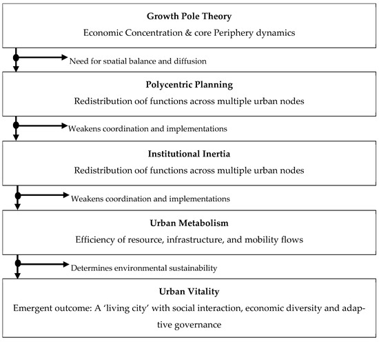
For Sofifi, therefore, cultivating urban vitality represents both a diagnostic tool and a developmental goal a way to measure whether the capital relocation has produced not just a new administrative zone but a living, inclusive, and adaptive urban system (Figure 1). Achieving this requires coordinated planning, investment in public life, and a governance model that treats citizens not merely as bureaucratic subjects but as active participants in the making of a new capital city.
Figure 1.
Conceptual framework showing how economic, spatial, institutional, ecological, and equity factors interact to shape urban vitality in capital relocation. Source: Author, 2025.
3. Comparative Global Experiences
3.1. Data and Indicators for Cross-Case Comparison
To strengthen the empirical basis of this comparative section, relocation impacts are assessed across two spatial units: (i) the former capital city/metropolitan region and (ii) the host/new capital region. Impacts are evaluated using a consistent set of city-level domains that commonly reflect relocation outcomes: demographic change, economic restructuring, land and housing dynamics, infrastructure and connectivity, and environmental/land-cover change.
This review adopts a structured, focused comparison approach by George & Bennett [30]. Each case is assessed using the same analytic dimensions aligned with the six theoretical lenses: (i) motivation and political vision; (ii) institutional integration and administrative centrality; (iii) spatial design and connectivity; (iv) economic anchoring and growth-pole effects; (v) distributional outcomes and spatial justice; and (vi) environmental risk and infrastructure-metabolic performance. Applying this common template strengthens synthesis and reduces purely sequential case narration.
The cross-case synthesis draws on secondary evidence from official statistics and government planning/budget documents, internationally harmonized datasets where available, and widely used remote-sensing proxies for urban expansion and land-cover change. Peer-reviewed case studies are used to interpret context and triangulate the direction of change. Table 1 summarizes the impact domains, indicators, and data sources used in the cross-case comparison.
Table 1.
Impact domains, indicators, and data sources used in the cross-case comparison.
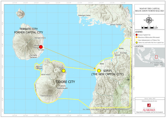
Capital relocation has been practiced in many regions as a strategy to redistribute development, improve governance efficiency, and foster regional balance. However, international experience shows that outcomes vary widely, depending on political vision, institutional capacity, and spatial integration. The following section reviews six key cases Abuja (Nigeria), Brasília (Brazil), Putrajaya (Malaysia), Naypyidaw (Myanmar), Randstad (Netherlands), and Nusantara (Indonesia) to identify recurring patterns of success and failure relevant to the case of North Maluku and Sofifi. The case of North Maluku, particularly the spatial relationship among Sofifi, Ternate, and Tidore, provides a contextual reference for understanding capital relocation in archipelagic regions. As shown in Figure 2, these three urban centers form an inter-island administrative system where Sofifi functions as the formal capital while Ternate remains the dominant economic hub.
Figure 2.
Map of the provincial capital relocation in North Maluku. Source: Author, 2025.
3.2. Abuja, Nigeria: Centralized Planning and Regional Balance
Abuja, inaugurated in 1991 to replace Lagos, was designed to relieve congestion and political tension in the coastal metropolis. Guided by the Abuja Master Plan Federal Capital Development Authority, in Kolade [31], the relocation aimed to promote territorial balance through centralized planning and equitable land distribution. Studies by Haryanto [32] and Obiadi et al. [33] note that Abuja succeeded symbolically and administratively but produced uneven social outcomes: rapid urban growth generated elite enclaves and informal settlements on its periphery. The case highlights the enduring tension between growth-pole efficiency and spatial justice—strong institutional control may accelerate development, yet without redistribution, inequality persists.
Abuja illustrates that relocation can create a new administrative growth pole when institutional authority, funding, and spatial design are aligned; however, sustaining legitimacy requires spatial justice safeguards so the benefits of centralization are broadly shared.
3.3. Brasília, Brazil: Modernist Vision and Social Fragmentation
The relocation of Brazil’s capital from Rio de Janeiro to Brasília in 1960 embodied the ideals of growth-pole and territorial integration theories. Designed by Lúcio Costa and Oscar Niemeyer, Brasília symbolized a modernist vision of national progress through spatial order and monumental form. However, as Holston 1989 in Kolb [34] and Jessop [35] observe, the city’s planned hierarchy produced deep socio-spatial divisions: government officials and middle-class elites occupied the planned core, while construction workers and low-income migrants were relegated to peripheral satellite cities. Despite its administrative efficiency, Brasília suffered from a lack of urban vitality. The emphasis on car-oriented avenues, vast open plazas, and functional zoning discouraged public life and social interaction. The case demonstrates that physical planning alone cannot generate social inclusion or everyday urban vibrancy, a pattern that continues to inform critiques of modernist capital planning worldwide.
Brasília shows how a powerful modernist vision can shift administrative centrality, yet weak attention to everyday urban vitality and distributive outcomes can reproduce segregation and leave the “capital city” socially fragmented.
3.4. Putrajaya, Malaysia: Smart Governance and Green Urbanism
Built in the 1990s to decentralize Kuala Lumpur, Putrajaya represents an attempt to merge smart city governance with ecological design. Its plan integrates digital administration, stormwater management, and expansive green corridors (Chai & Beh; Lim et al.) [36]. The city exemplifies how polycentric development and urban metabolism principles can coexist, balancing technological infrastructure with environmental resilience. Nonetheless, research notes a lingering deficit in urban vitality: while institutionally efficient, Putrajaya remains quiet after office hours, underscoring that social vibrancy and civic culture evolve more slowly than physical infrastructure.
Putrajaya highlights that strong institutional coordination and infrastructure provisioning (urban metabolism) can deliver an efficient administrative city, but long-term success still depends on cultivating mixed-use vitality beyond the state sector.
3.5. Naypyidaw, Myanmar: Rapid Relocation and Social Vacuum
Constructed in 2005 under military direction, Naypyidaw epitomizes a politically driven capital relocation executed with little public participation. Although equipped with monumental boulevards, administrative complexes, and grand pagodas, it suffers from extremely low density and limited economic activity. As Seekins [37] explains, the new capital was designed primarily to consolidate military control and symbolize Burman identity, rather than to promote inclusive governance or economic vitality. Similarly, Pardee [38] interprets Naypyidaw as an “authoritarian ecosystem,” where spatial design its vast highways, segregated zones, and monumental symmetry, functions as an instrument of discipline and propaganda.
The absence of participatory governance and community integration has rendered the city sterile, an example of institutional inertia in which bureaucracy moved but social life did not follow. Naypyidaw thus stands as a cautionary lesson: relocation without legitimacy, civic engagement, and social infrastructure produces isolation rather than resilience.
Naypyidaw demonstrates that rapid top-down relocation can relocate buildings and ministries without creating urban vitality; without social integration and functional density, the city risks becoming administratively present but socially hollow.
3.6. Randstad, Netherlands: A Mature Polycentric System
The Randstad region, encompassing Amsterdam, Rotterdam, The Hague, and Utrecht, stands as one of the most successful examples of a polycentric metropolitan model in Europe. Rather than concentrating power in a single urban core, Dutch planners deliberately distributed administrative, economic, and cultural functions across multiple interconnected cities to prevent over-centralization and ensure spatial balance. This strategic dispersion has been supported by a highly integrated transport system, land-use coordination, and robust environmental safeguards that collectively sustain both urban vitality and regional equity. As Hall and Pain, 2006 in Spaans et al. [39] highlight in The Polycentric Metropolis, the Randstad exemplifies how functional differentiation among cities, Amsterdam as the financial and cultural hub, Rotterdam as the global port, The Hague as the seat of governance, and Utrecht as a transport nexus, creates a resilient urban ecosystem that thrives on collaboration rather than competition. Complementing this, the Holland [40] review of Randstad Holland emphasizes that coordinated multi-level governance and infrastructure investment have been crucial in maintaining competitiveness while mitigating spatial inequality. Together, these cases demonstrate that the Randstad’s success lies not only in its physical connectivity but also in its institutional integration, a lesson highly relevant for archipelagic regions like North Maluku, where balanced growth across dispersed nodes remains a key challenge.
The Randstad case clarifies how polycentric development can be feasible when cities have complementary roles, strong connectivity, and sustained governance coordination—conditions that prevent over-concentration in a single core.
3.7. Nusantara, Indonesia: Ambitious Transition and Emerging Uncertainties
Indonesia’s new capital, Nusantara, now under construction in East Kalimantan, is among the region’s most ambitious state-led spatial transformations. Conceived to relieve Jakarta’s congestion and rebalance national development, it aspires to integrate polycentric and sustainable urbanism Firman [41]. The official vision promotes digital governance, green infrastructure, and urban metabolism to reduce ecological footprint and create a regenerative city. Yet, as Syaban & Appiah-Opoku [42] reveal, the project exposes overlapping environmental, institutional, and social tensions. Large-scale land conversion from forest and agricultural zones has generated disputes over indigenous rights, ecological loss, and unequal benefit distribution. Their study shows that despite advanced physical planning, institutional inertia and fragmented governance threaten to reproduce old patterns of centralization and inequality.
The authors argue that Nusantara’s success depends on deep institutional transformation—embedding participatory governance and inter-regional coordination—rather than mere relocation of administrative buildings. They caution that the capital’s sustainability will hinge on its ability to cultivate urban vitality through economic diversification, community engagement, and local identity formation.
In this sense, Nusantara and Sofifi share structural parallels. Both are state-driven relocation projects aiming to redistribute growth yet constrained by uneven institutional capacity and weak social integration. Their comparison underscores a broader lesson: the real test of capital relocation lies not in architectural ambition but in creating a living city that harmonizes governance, ecology, and social inclusion.
Nusantara suggests that ambitious relocation can catalyze new growth dynamics, but its outcomes will depend on how institutional consolidation, infrastructure flows, and equity safeguards co-evolve to produce a livable and legitimate capital.
3.8. Comparative Synthesis
A synthesis of these cases reveals a consistent pattern. Successful capital relocations—such as Putrajaya and Randstad combine clear political vision, strong institutional frameworks, and integrated spatial design that encourage long-term urban vitality (Table 2). In contrast, failures such as Brasília and Naypyidaw highlight the consequences of institutional inertia, top-down planning, and lack of public life. Abuja demonstrates both the promise and pitfalls of centralized growth, while Nusantara represents an ongoing experiment that embodies both potential and risk.
Table 2.
Comparative Summary of Global Capital Relocations.
Across these examples, three insights emerge:
- Physical relocation alone cannot ensure economic or social transformation without accompanying institutional reform.
- Polycentric and participatory planning better sustains regional equity and functional diversity.
- Urban vitality, the presence of active public life, inclusive governance, and balanced spatial metabolism, serves as the ultimate indicator of a successful capital relocation.
4. Discussion
The comparative analysis of global capital relocations, when viewed through the theoretical frameworks of growth pole, polycentricity, institutional inertia, urban metabolism, spatial justice, and urban vitality, provides valuable insights into the challenges facing Sofifi and the broader spatial governance of North Maluku. The discussion below synthesizes these insights to highlight the structural and conceptual conditions necessary for transforming Sofifi from a symbolic administrative seat into a living, resilient, and inclusive city.
4.1. Political Vision and Institutional Integration
Across all cases, the presence of a coherent political vision supported by consistent institutional frameworks emerges as the most decisive factor in successful capital relocation.
Abuja and Putrajaya demonstrate that when planning institutions are endowed with clear mandates, adequate resources, and political legitimacy, the relocation process can generate functional administrative and spatial transformation.
By contrast, Sofifi and Naypyidaw illustrate how weak coordination and fragmented governance produce partial relocations, where administrative functions shift formally, but institutional routines remain anchored in the old capital.
In North Maluku, institutional inertia has constrained the full realization of Sofifi’s capital functions. The persistence of administrative operations in Ternate, combined with limited inter-agency coordination and resource allocation, reflects an incomplete institutional transition. Drawing from Syaban & Appiah-Opoku [42], this pattern resembles that of Nusantara, where land-use transformation proceeds faster than governance reform. Both cases emphasize that physical relocation cannot substitute for institutional restructuring. For Sofifi, success depends on the establishment of a clear governance architecture that integrates spatial planning, budget alignment, and human resources into a unified administrative ecosystem. This requires decisive political leadership, cross-sectoral collaboration, and a multi-level governance mechanism that connects provincial, municipal, and community actors.
4.2. Spatial Design and Polycentric Regional Development
From a spatial perspective, polycentric development offers a strategic framework for overcoming the monocentric dominance of Ternate. The Randstad model demonstrates how interlinked cities can function as complementary nodes rather than competitors.
Similarly, Putrajaya and Abuja reveal that balanced territorial planning can redistribute functions and relieve pressure from existing cores provided that connectivity and accessibility are adequately maintained.
In contrast, Sofifi remains spatially isolated, with limited transport infrastructure and weak economic linkages to surrounding settlements on Halmahera Island. To operationalize polycentric development, Sofifi’s planning must extend beyond administrative boundaries and treat Ternate, Tidore, and Sofifi as components of a connected urban archipelago system. Enhancing ferry routes, inter-island logistics, and digital connectivity can transform what is currently a fragmented set of nodes into an integrated network. This approach would align with Indonesia’s national polycentric vision embedded in the development of Nusantara, while adapting it to North Maluku’s unique island geography. Such integration would enable functional complementarity. Ternate as the economic hub, Sofifi as the administrative core, and Tidore as a cultural and educational center, thus creating a balanced regional structure that supports both efficiency and inclusivity.
Preliminary Feasibility of a Ternate–Tidore–Sofifi Polycentric System
A basic spatial feasibility signal is the short marine crossing between Sofifi and Ternate: fast-boat services make daily commuting physically possible and already routine, ANTARA News [17]. Recent transport service developments have also explicitly targeted inter-island mobility between Ternate and Sofifi, with reported travel times on the order of tens of minutes, ANTARA News [18].
However, physical feasibility does not automatically translate into economic or governance feasibility. A polycentric system requires functional complementarity across nodes and transport costs (time, reliability, and affordability) low enough to sustain two-way flows of labor, services, and investment. With population and higher-order services still concentrated in established urban cores, Sofifi risks remaining a weekday administrative node unless housing, service provision, and local economic anchors are developed in tandem. A full feasibility assessment would therefore combine spatial analysis (travel-time and cost matrices), administrative location data (where agencies actually operate), and temporal indicators of vitality (e.g., nighttime lights, business density, and public-event frequency).
4.3. Urban Vitality and the Making of a Living City
The global review underscores urban vitality as a critical measure of whether relocated capitals evolve into socially vibrant and economically resilient cities. Brasília and Naypyidaw provide cautionary examples of cities that achieved monumental physical form but lacked everyday life and public interaction. Conversely, Putrajaya and Randstad illustrate that sustained vitality arises from integrating spatial design with human experience, where mixed land uses, accessible mobility, and inclusive public spaces enable continuous urban rhythms.
In Sofifi, vitality remains limited due to weak population density, daily outmigration of civil servants to Ternate, and underdeveloped urban amenities. The absence of lively markets, social gathering spaces, and nighttime activities results in a city that functions bureaucratically but not socially. Cultivating vitality, therefore, requires a shift from building the city to animating the city. This involves promoting mixed-use development, encouraging small-scale entrepreneurship, investing in cultural and public events, and ensuring that planning decisions respond to local communities rather than top-down directives. As Jacobs [27] argued, cities thrive when they foster diversity, density, and human interaction conditions that Sofifi must actively design for if it is to become more than an administrative enclave.
Recent official statistics illustrate this gap. Sofifi Village recorded 2663 residents in 2022 within North Oba District (Oba Utara), which totaled 20,229 residents and a density of 31 persons/km2 in BPS-Statistics of Tidore Islands Municipality [43]. In contrast, Ternate City—the former capital and current economic core—had 204,920 residents in 2023 with a density of 1263 persons/km2 in BPS-Statistics of Ternate Municipality [44]. Service indicators also reflect Sofifi’s still-thin urban functions: Sofifi had no registered hotels and only five guesthouses in 2021, underscoring a limited-service economy compared with Ternate’s established commerce and tourism sector in BPS-Statistics of Tidore Islands Municipality [43].
4.4. Spatial Justice and Equitable Access
The relocation of the capital to Sofifi was originally intended to promote spatial justice within North Maluku by bringing government services closer to communities in the Halmahera mainland. Yet, two decades later, disparities in access remain pronounced. Ternate’s dominance in commerce, education, and healthcare continues to marginalize peripheral areas, reflecting the persistence of spatial injustice identified by Soja [25]. As observed in Abuja, centralization of investment without equitable redistribution reproduces inequality under new spatial arrangements.
For Sofifi, pursuing spatial justice requires deliberate redistribution of public investment and institutional functions. Establishing branch offices, regional campuses, and specialized service centers in Sofifi can reduce dependency on Ternate. Similarly, housing programs for civil servants and improved transport access would incentivize permanent settlement and stimulate local demand. Embedding spatial equity into policy thus means translating administrative relocation into tangible improvements in access, opportunity, and participation for the wider population.
4.5. Toward an Integrated Framework: From Administrative Relocation to Living Governance
Synthesizing the comparative cases with the Sofifi context, the six theoretical lenses yield distinct but complementary insights. Growth pole theory clarifies why Ternate’s cumulative advantages persist; polycentric development reframes the region as an inter-island system that requires deliberate functional differentiation; institutional inertia explains why formal designation does not automatically relocate routines; urban metabolism highlights whether infrastructure and mobility flows can sustain everyday life; spatial justice focuses attention on distributional impacts and participation; and urban vitality evaluates whether Sofifi becomes a living city rather than a daytime administrative enclave.
Drawing on these insights, an integrated, evidence-informed pathway for Sofifi’s development can be outlined as follows:
- Growth-Pole Rebalancing: Establish clear economic anchors in Sofifi that can generate durable activity beyond government offices (e.g., education and training functions, health services, logistics-support services, and MSME clusters) so that employment and service demand begin to concentrate locally rather than defaulting to Ternate.
- Polycentric Connectivity: Treat Ternate–Tidore–Sofifi as a connected urban archipelago system by strengthening reliable maritime transport, inter-island logistics, and digital connectivity, while assigning complementary roles across nodes to avoid zero-sum competition and reduce dependence on a single core.
- Institutional Transformation: Reduce institutional inertia through a clear administrative architecture that locates core provincial functions in Sofifi, aligns budgets and staffing with the relocation mandate, and creates incentives (housing, services, and career-related) that make permanent settlement and routine operations feasible.
- Urban Metabolism and Risk-Sensitive Infrastructure: Prioritize water, sanitation, energy, waste, and mobility systems that can sustain daily life and reduce operational disruption. Risk-sensitive planning should be embedded in infrastructure investment so that continuity of governance and services does not remain concentrated in hazard-prone or spatially constrained areas.
- Spatial Justice Mechanisms: Translate relocation into equitable access by redistributing public services and investments toward Halmahera communities, improving affordability and land governance, and creating participation channels so local residents and stakeholders shape the benefits and trade-offs of capital development.
- Public Engagement and Participatory Governance: Institutionalize citizen surveys/polls, community forums, and collaboration with local activists and civil society organizations to identify needs, monitor service delivery, and build legitimacy for a phased and transparent transition.
- Urban Vitality Strategies: Build a mixed-use, walkable civic core with markets, public spaces, cultural programming, and housing that supports life after office hours. Vitality should be monitored through simple temporal indicators (weekday vs. weekend activity, business diversity, public-space use) to ensure Sofifi’s urban life co-evolves with administrative functions.
Together, these strategies shift relocation from symbolic status to functional governance, enabling Sofifi to develop institutional legitimacy, socio-economic density, and everyday public life while maintaining complementary linkages with Ternate and Tidore.
4.6. Limitations and Future Research
This paper primarily relies on secondary literature and policy documentation to conduct cross-case synthesis and theory-driven interpretation. While this approach is appropriate for concept building and lesson drawing, it limits the precision of claims about Sofifi’s contemporary vitality and the magnitude of relocation impacts, and it does not directly document public actors’ perceptions (residents, civil servants, and local activists) of the transition process. Future work should therefore incorporate primary empirical evidence, including: (i) structured interviews with provincial and municipal agencies, civil servants, and local communities; (ii) household/commuter surveys and citizen polls to capture needs, constraints, and lived experience of service access; (iii) administrative location and staffing data to map where government functions actually operate; (iv) spatial accessibility analysis (travel time/cost across islands); and (v) longitudinal vitality proxies (nighttime lights, business registry density, service-use patterns, and event calendars). Such evidence would allow a stronger feasibility assessment of polycentric governance and a more rigorous evaluation of distributional outcomes.
5. Conclusions
This study answers the research question by showing that Sofifi has not emerged as the de facto provincial capital because the relocation was implemented primarily as a formal administrative designation without a full functional transition. Ternate’s cumulative advantages as the existing growth pole, combined with limited everyday services and housing in Sofifi, persistent cross-island commuting, and institutional routines anchored in the former center, have produced a partial-relocation equilibrium: government presence exists in Sofifi, but economic and social life—and many operational functions—remain concentrated elsewhere.
Across the comparative cases, the synthesis indicates that capital relocation produces new insights when it is evaluated as a coupled system: institutional reform and inter-governmental coordination must progress alongside spatial integration, infrastructure provisioning, and distributive safeguards. In this framing, urban vitality functions as the integrative outcome that signals whether relocation has created a living city with sustained public life, diversified economic activity, and adaptive governance. Because this study examines a provincial capital transition, the problems identified and recommendations proposed speak most directly to subnational relocations in Indonesia and comparable archipelagic settings; however, similar principles may inform national capital relocations, with due attention to differences in scale, budget, and governance arrangements.
Policy implications for North Maluku follow directly from this evidence. A viable pathway for Sofifi requires: (i) institutional consolidation that makes Sofifi the default location for routine provincial operations; (ii) reliable and affordable inter-island connectivity paired with local housing and services to reduce commuter dependence; (iii) targeted economic anchors that generate employment and service demand beyond government offices; and (iv) participatory, equity-oriented planning to manage land, affordability, and benefit distribution so relocation strengthens legitimacy rather than reproducing spatial inequality.
Overall, the success of relocation should be assessed not by symbolic status or the presence of administrative buildings, but by whether governance capacity and everyday urban life co-evolve to produce a functional, inclusive, and resilient provincial capital in an archipelagic setting.
Author Contributions
Conceptualization, M.R.H.A.; methodology, M.R.H.A.; software, M.R.H.A.; validation, M.R.H.A.; formal analysis, M.R.H.A.; investigation, M.R.H.A.; resources, M.R.H.A.; data curation, M.R.H.A.; writing—original draft preparation, M.R.H.A.; writing—review and editing, A.S.N.S.; visualization, M.R.H.A.; supervision, S.A.-O.; project administration, M.R.H.A. All authors have read and agreed to the published version of the manuscript.
Funding
This research was supported by the Indonesia Endowment Fund for Education (LPDP), Republic of Indonesia (Grant No. 202405222502012), and by the Department of Geography and the Environment.
Data Availability Statement
This study is based on publicly available secondary data and literature sources. No new datasets were generated; all sources used are cited in the References.
Conflicts of Interest
The author declares that there is no conflict of interest regarding the publication of this paper.
References
- Undang-Undang RI Nomor 23 Tahun 2014, “Under Law No. 23/2014 on Local Government”; Kementerian Sekretariat Negara RI. Dewan Perwakilan Rakyat Republik Indonesia Dan Presiden Republik Indonesia: Jakarta, Indonesia, 2014.
- Perroux, F. Economic Space: Theory and Applications. Q. J. Econ. 1950, 64, 89–104. [Google Scholar] [CrossRef] [Scilit]
- Awaluddin; Faitanu, I.; Hasan, H. Pemekaran Kota Sofifi Maluku Utara sebagai Daerah Persiapan Otonomi Baru Ditinjau dari UU No 23 Tahun 2014. Available online: https://media.neliti.com/media/publications/437123-none-71f7f6c5.pdf (accessed on 23 September 2025).
- Muhammad, Z.M.; Samiun, D.N.I. Muhammad. Kelayakan Perencanaan Pusat Kawasaan Terintegrasi Di Ibu Kota Sofifi. Posttimur.com. Available online: https://www.posttimur.com/2021/12/12/kelayakan-perencanaan-pusat-kawasaan-terintegrasi-di-ibu-kota-sofifi/ (accessed on 23 September 2025).
- Gavrilă-Paven, I.; Bele, I. Developing a growth pole: Theory and reality. In Management, Organizations and Society; Agroinform: Budapest, Hungary, 2017. [Google Scholar] [CrossRef] [Scilit]
- McCann, P.; Sheppard, S. The rise, fall and rise again of industrial location theory. Reg. Stud. 2003, 37, 649–663. [Google Scholar] [CrossRef] [Scilit]
- Davoudi, S. Polycentricity in European spatial planning: From an analytical tool to a normative agenda. Eur. Plan. Stud. 2003, 11, 979–999. [Google Scholar] [CrossRef] [Scilit]
- Zhou, S.; Zhai, G. A Multi-Hazard Risk Assessment Framework for Urban Disaster Prevention Planning: A Case Study of Xiamen, China. Land 2023, 12, 1884. [Google Scholar] [CrossRef] [Scilit]
- Djumantara, R.H.; Gede, D.; Wisana, K. The Impact of The Trans Java Toll Road on Industry Micro Small Food and Beverage Sector. Oikonomia J. Manag. Econ. Account. 2025, 2, 186–197. [Google Scholar] [CrossRef] [Scilit]
- Poljašević, B.Z.; Gričnik, A.M.; Žižek, S.Š. Human Resource Management in Public Administration: The Ongoing Tension Between Reform Requirements and Resistance to Change. Adm. Sci. 2025, 15, 94. [Google Scholar] [CrossRef] [Scilit]
- Sally, R.; Sihombing, M.; Riwayati, A.; Judijanto, L. Dinamika Administrasi Publik. 2024. Available online: https://www.researchgate.net/publication/380734592 (accessed on 23 September 2025).
- Wisner, B.; Davis, I. At Risk: Natural Hazards. 2004. Available online: https://www.researchgate.net/publication/245532449 (accessed on 24 September 2025).
- Carlino, S. Review article: Brief history of volcanic risk in the Neapolitan area (Campania, southern Italy): A critical review. Nat. Hazards Earth Syst. Sci. 2021, 21, 3097–3112. [Google Scholar] [CrossRef] [Scilit]
- Law No. 46/1999; On the Establishment of North Maluku Province. Republic of Indonesia: Jakarta, Indonesia, 1999.
- Kompas.com. Profil Sofifi, Ibu Kota Provinsi Maluku Utara. Sofifi. 2022. Available online: https://regional.kompas.com/read/2022/11/19/163505778/profil-sofifi-ibu-kota-provinsi-maluku-utara?page=all (accessed on 24 September 2025).
- Kementerian ESDM RI. Kementerian ESDM RI—Profil—Tugas & Fungsi. Available online: https://www.esdm.go.id/id/profil/tugas-fungsi (accessed on 24 September 2025).
- ANTARA News. Gubernur Malut Komitmen Percepat Aktivitas Instansi Vertikal ke Sofifi; ANTARA News Ambon: Ambon, Indonesia, 2025. [Google Scholar]
- ANTARA News. Maluku Utara Resmi Buka Operasional Pelabuhan Sofifi; ANTARA News: Sofifi, Indonesia, 2025. [Google Scholar]
- Fischer-Kowalski, M. Society’s Metabolism The Intellectual History of Materials Flow Analysis, Part I. J. Ind. Ecol. 1998, 2, 4. [Google Scholar]
- Kennedy, C.; Pincetl, S.; Bunje, P. The study of urban metabolism and its applications to urban planning and design. Environ. Pollut. 2011, 159, 1965–1973. [Google Scholar] [CrossRef] [Scilit]
- Thomson, G.; Newman, P. Urban fabrics and urban metabolism—From sustainable to regenerative cities. Resour. Conserv. Recycl. 2018, 132, 218–229. [Google Scholar] [CrossRef] [Scilit]
- Zhang, Y. Urban metabolism: A review of research methodologies. Environ. Pollut. 2013, 178, 463–473. [Google Scholar] [CrossRef] [Scilit]
- Ward, P.J.; Pauw, W.P.; van Buuren, M.W.; Marfai, M.A. Governance of flood risk management in a time of climate change: The cases of Jakarta and Rotterdam. Environ. Politics 2013, 22, 518–536. [Google Scholar] [CrossRef] [Scilit]
- Luonila, M.; Kumpulainen, K.; Leppänen, A.; Koskinen-Koivisto, E.; Ruokolainen, O. Community resilience and cultural sustainability in two Finnish urban neighbourhoods. Front. Political Sci. 2023, 5, 1213240. [Google Scholar] [CrossRef] [Scilit]
- Soja, E.W. The city and spatial justice. Justice Spatiale 2009, 1, 1–5. [Google Scholar]
- Mungkasa, O. Perencanaan Tata Ruang: Sebuah Pengantar 1. 2020. Available online: http://pittsburgh.academia.edu/oswarmungkasa (accessed on 26 September 2025).
- Jacobs, J. The Death and Life of Great American Cities; Vintage Books; Random House: New York, NY, USA, 1961. [Google Scholar]
- Katsavounidou, G. Life Between Buildings: Using Public Space: The History of Jan Gehl’s Book and the Legacy of its Philosophy for Designing Cities at Human Scale; Institutionelles Repositorium der Leibniz Universität Hannover: Hannover, Germany, 2024. [Google Scholar] [CrossRef]
- MalutProv. Resmikan Pelabuhan Sofifi, Gubernur Harap Bisa Tingkatkan Inklusivitas Ekonomi Malut; Pemerintah Provinsi Maluku Utara: Ternate, Indonesia, 2025. [Google Scholar]
- Mitchell, R.; Bernauer, T. Empirical Research in International Environmental Policy: Designing Qualitative Case Studies. J. Environ. Dev. 2005, 20, 4–31. [Google Scholar]
- Fakunle, K. Abuja Master Plan (1979): All You Should Know About It; Explore Abuja: Abuja, Nigeria, 2023. [Google Scholar]
- Haryanto, A. Faktor Geografis dan Konsepsi Peran Nasional sebagai Sumber Politik Luar Negeri Indonesia. J. Hub. Int. 2015, 4, 136–147. [Google Scholar] [CrossRef] [Scilit]
- Obiadi, B.N.; Ezezue, A.M.; Uduak, P.U. Abuja: Nigeria’s Spatial Economic Turmoil and Urban Development Disarray. Curr. Urban Stud. 2019, 7, 371–398. [Google Scholar] [CrossRef]
- Kolb, D. The Modernist City (Holston). Vis. Anthropol. Rev. 1990, 6, 94–97. [Google Scholar] [CrossRef] [Scilit]
- Jessop, B. La economía política de la escala y la construcción de las regiones transfronterizas. Rev. EURE Rev. de Estud. Urbano Reg. 2004, 30, 25–41. [Google Scholar]
- Chai, H.Y.; Beh, L.S. Putrajaya Smart City: A Journey Traces Back to Its Past, Now and Near Future. Serbian J. Manag. 2025, 20, 173–196. [Google Scholar] [CrossRef] [Scilit]
- Seekins, D. ‘Runaway chickens’ and Myanmar identity Relocating Burma’s capital. City 2009, 13, 63–70. [Google Scholar] [CrossRef] [Scilit]
- Pardee, G. Auspicious Urbanisms: Security and Propaganda in Myanmar’s New Capital. 2017. Available online: https://averyreview.com/issues/24/auspicious-urbanisms (accessed on 28 September 2025).
- Spaans, M.; Zonneveld, W.; Stead, D. Governance and power in the metropolitan regions of the Randstad. In The Randstad; Routledge: Abingdon, UK, 2020; pp. 255–280. [Google Scholar] [CrossRef] [Scilit]
- Holland, R. OECD Territorial Reviews; OECD: Paris, France, 2007. [Google Scholar]
- Firman, T. New town development in Jakarta Metropolitan Region: A perspective of spatial segregation. Habitat Int. 2004, 28, 349–368. [Google Scholar] [CrossRef] [Scilit]
- Syaban, A.S.N.; Appiah-Opoku, S. Building Indonesia’s new capital city: An in-depth analysis of prospects and challenges from current capital city of Jakarta to Kalimantan. Urban Plan. Transp. Res. 2023, 11, 2559517. [Google Scholar] [CrossRef] [Scilit]
- BPS Kota Tidore Kepulauan Badan Pusat. Statistik Daerah Kota Tidore Kepulauan 2023; Badan Pusat Statistik Kota Tidore Kepulauan: Tidore, Indonesia, 2023. [Google Scholar]
- BPS Kota Ternate Badan. Statistik Daerah Kota Ternate 2024; Badan Pusat Statistik Kota Ternate: Ternate, Indonesia, 2024. [Google Scholar]

Disclaimer/Publisher’s Note: The statements, opinions and data contained in all publications are solely those of the individual author(s) and contributor(s) and not of MDPI and/or the editor(s). MDPI and/or the editor(s) disclaim responsibility for any injury to people or property resulting from any ideas, methods, instructions or products referred to in the content. |
© 2026 by the authors. Licensee MDPI, Basel, Switzerland. This article is an open access article distributed under the terms and conditions of the Creative Commons Attribution (CC BY) license.