


Abstract
Flood inundation mapping (FIM) is essential in disaster risk management, infrastructure planning, and climate adaptation. Traditional hydrodynamic models, such as the Hydrologic Engineering Center’s River Analysis System (HEC-RAS) and LISFLOOD-Floodplain (LISFLOOD-FP), provide physically interpretable flood simulations but are often data- and computation-intensive and difficult to scale across regions. In recent years, machine learning (ML) and deep learning (DL) approaches have emerged as data-driven alternatives that leverage remote sensing observations, digital elevation models (DEMs), and hydro-climatic datasets to enable scalable and near-real-time flood mapping. Our review synthesizes recent advances in ML-based flood inundation mapping, categorizing methods into traditional machine learning techniques (e.g., Random Forest (RF), Support Vector Machines (SVM), Gradient Boosting (GB)), deep learning architectures (e.g., Convolutional Neural Networks (CNNs), U-Net, Long Short-Term Memory networks (LSTM)), and emerging hybrid and physics-informed frameworks. We evaluate model performance across flood extent and flood depth estimation tasks, highlighting strengths, limitations, and common benchmarking practices reported in the literature. The review identifies key challenges related to model interpretability, data bias, transferability, and regulatory acceptance, and highlights recent progress in explainable artificial intelligence (XAI), uncertainty-aware modeling, and physics-informed learning as pathways toward operational adoption. By unifying terminology, performance metrics, and methodological comparisons, this review provides a coherent framework for advancing trustworthy, scalable, and decision-relevant flood inundation mapping under increasing climate-driven flood risk.
1. Introduction
Flooding is one of the most frequent and destructive natural hazards worldwide, causing substantial human, economic, and environmental losses each year. Recent assessments show that flood risk is increasing due to the combined effects of climate change, rapid urbanization, and expanding infrastructure in flood-prone areas [1,2]. In many regions, increases in extreme precipitation have amplified flood hazards, while land-use change and population growth have increased exposure and vulnerability, leading to disproportionate impacts even during moderate flood events [3,4,5,6].
Accurate and timely flood inundation mapping (FIM) is therefore essential in disaster preparedness, emergency response, infrastructure planning, and long-term flood risk management. FIM translates hydrologic and hydraulic processes into spatially explicit information such as flood extent and flood depth, which are often analyzed with damage estimation, evacuation planning, and insurance and regulatory frameworks [7,8]. Traditionally, flood inundation maps have been produced using physically based hydrodynamic models, such as HEC-RAS, MIKE FLOOD, and LISFLOOD-FP. They simulate water movement using channel geometry, terrain elevation, boundary conditions, and meteorological forcing [8,9,10]. Whereas, process-based hydrodynamic models provide physically interpretable and engineering-consistent simulations, they are often computationally expensive, data intensive, and difficult to scale across regions or near-real-time applications. For example, high-resolution simulations require detailed bathymetry, calibration data, and substantial computational resources, which are frequently unavailable in data-sparse or rapidly changing regions [8,11,12]. As a result, many flood-prone areas worldwide remain unmapped or rely on outdated flood hazard information, limiting effective risk reduction and planning [13,14].
The growing availability of Earth observation data has created new opportunities to complement or augment traditional flood modeling approaches. Satellite platforms such as Sentinel-1 SAR, Sentinel-2 multispectral imagery, MODIS, and commercial high-resolution sensors provide repeated, synoptic observations of flood events across diverse geographic and climatic settings [15,16]. In particular, SAR imagery has proven highly effective for flood detection due to its ability to operate independently of daylight and cloud cover, which is critical during extreme weather events [17,18,19].
In parallel with these data advances, machine learning (ML) and deep learning (DL) methods have emerged as tools for flood inundation mapping. Traditional ML approaches, including Random Forest, gradient boosting, logistic regression, and support vector machines, have been widely applied for flood susceptibility and hazard mapping by learning statistical relationships between historical flood occurrence and explanatory variables such as topography, land cover, drainage networks, and rainfall proxies [20,21,22]. These models offer computational efficiency and flexibility but rely on handcrafted features and struggle to capture complex spatial patterns in high-resolution imagery.
More recently, deep learning architectures have transformed FIM by enabling automated feature extraction and pixel-wise flood segmentation from satellite imagery. Convolutional neural networks (CNNs), mainly U-Net-type architectures, have shown strong performance for flood extent mapping using SAR and multispectral data [23,24,25]. Recurrent neural networks and sequence models, such as LSTM and GRU, have also been applied to capture temporal dynamics for flood forecasting and water level prediction [26,27]. More recently, transformer-based architectures and vision transformers have shown promising generalization performance across diverse flood events and regions [28,29]. These methodological advances are reviewed and benchmarked in detail in Section 5 and Section 6.
Despite these advances, the operational adoption of ML-based FIM remains limited. Key challenges include model interpretability, sensitivity to training data quality, limited transferability across regions, and the lack of standardized benchmarking against physics-based models among others [30,31,32]. Increasingly, researchers are addressing these concerns through hybrid AI–hydrodynamic models, physics-informed learning, explainable AI (XAI), and uncertainty-aware frameworks that provide probabilistic flood predictions rather than deterministic outputs [33,34,35].
Against this background, this review synthesizes recent developments in machine learning and deep learning for flood inundation mapping, with a focus on methods published up to recently. The paper systematically reviews traditional ML, deep learning, hybrid physics-AI, and uncertainty-aware approaches for both flood extent and flood depth estimation. In addition, it standardizes performance metrics and benchmarking practices, critically evaluates model strengths and limitations, and discusses pathways toward operational and regulatory adoption.
2. Conceptual Foundations of Flood Inundation Mapping
Flood-related mapping products are central in hydrology, flood risk management, and disaster response. However, terms such as flood susceptibility, flood hazard, flood risk, and flood inundation mapping are often used inconsistently/interchangeably in the literature, despite referring to distinct concepts and modeling objectives [8,36,37]. Clarifying these distinctions is needed for interpreting recent advances in machine learning-based flood studies and for ensuring meaningful comparison among different modeling approaches.
2.1. Flooding as a Spatial–Hydrological Phenomenon
Flooding is a space-time distributed hydrologic process arising from the interaction of meteorological forcing, catchment characteristics, channel hydraulics, floodplain connectivity, and human alterations to the landscape [12,38]. Flood extent and depth are controlled not only by rainfall intensity and duration, but also by terrain elevation, slope, roughness, drainage efficiency, and floodplain storage capacity [9,39].
Because these controls vary across space and time, flood impacts are inherently heterogeneous, even within a single watershed or flood event [7]. As a result, flood mapping products must capture spatial variability explicitly, rather than relying solely on point-based or lumped indicators. This spatial complexity underpins the need for different flood mapping paradigms depending on the intended application.
2.2. Flood Susceptibility Mapping
Flood susceptibility mapping aims to identify areas that are more likely to experience flooding based on intrinsic environmental characteristics, independent of a specific flood scenario [22,40]. These maps typically express relative likelihood or propensity for flooding using terrain attributes, hydrological indices, land cover, soil properties, and proximity to drainage networks [41,42].
Flood susceptibility models are commonly developed using statistical or machine learning approaches trained on historical flood occurrence data [20,43]. The outputs are presented as continuous susceptibility indices or categorical classes such as low, moderate, and high susceptibility. While these products are useful for regional screening and land-use planning, they do not represent flood magnitude, inundation depth, or event-specific dynamics [36,37].
2.3. Flood Hazard Mapping
Flood hazard mapping quantifies the physical characteristics of flooding under defined hydrological or hydraulic scenarios, such as design storms or specified return periods. Typical hazard variables include flood extent, water depth, flow velocity, and occasionally flood duration [44,45].
Flood hazard maps are traditionally produced using physically based hydrodynamic models, which solve simplified forms of the shallow water equations to simulate flood propagation across river channels and floodplains [9,39,46]. These maps are scenario-dependent and are widely used in engineering design, insurance, and regulatory contexts. However, their production requires detailed topographic data, hydraulic parameters, and calibration information, making them computationally expensive and difficult to scale across large regions [8,47].
2.4. Flood Risk Mapping
Flood risk mapping integrates flood hazard information with exposure and vulnerability to estimate potential consequences such as economic losses, population affected, or infrastructure damage [7,21]. Risk is commonly conceptualized as the combination of hazard intensity, the presence of assets or populations, and their susceptibility to damage [48,49].
Flood inundation maps serve as a critical input to flood risk assessments, as errors in flood extent or depth propagate directly into exposure and loss estimates [7,37]. Although flood risk mapping is essential for decision-making, it is analytically distinct from flood inundation mapping itself, which focuses on the physical representation of flooding rather than its impacts.
2.5. Flood Inundation Mapping
Flood inundation mapping (FIM) refers specifically to the spatial delineation of flooded areas and the estimation of floodwater depth under given hydrological or hydraulic conditions [50,51]. Typical outputs include binary flood extent maps and continuous flood depth surfaces.
Traditionally, FIM has been produced using process-based hydrodynamic models such as HEC-RAS, MIKE FLOOD, and LISFLOOD-FP, which explicitly simulate water movement using channel geometry, terrain elevation, roughness parameters, and boundary conditions [9,38]. In addition to full hydrodynamic simulations, simplified terrain-based approaches such as the Height Above Nearest Drainage (HAND) model have been widely applied to support large-scale flood inundation mapping. HAND represents the vertical distance between each terrain cell and its nearest drainage channel derived from digital elevation models and is generated through hydrological conditioning and drainage network analysis [52,53,54]. Lower HAND values generally correspond to areas with higher inundation susceptibility, making the method computationally efficient for regional-scale floodplain delineation. HAND-based approaches have increasingly been integrated with machine learning models to improve spatial accuracy and correct systematic biases [26,55].
More recently, data-driven approaches have emerged that estimate inundation patterns using statistical inference and remote sensing observations. Regardless of methodology, the defining feature of FIM is its explicit spatial representation of inundation, distinguishing it from susceptibility, hazard, and risk mapping [49,56]. Flood inundation mapping plays an essential role in emergency response, evacuation planning, infrastructure design, and climate adaptation strategies, making improvements in its scalability and reliability a key research priority [8,47].
2.6. Image-Based Flood Observation Versus Flood Inundation Mapping
An important distinction in flood studies is between image-based flood observation and predictive flood inundation mapping. Image-based approaches use satellite imagery, particularly synthetic aperture radar and optical sensors, to detect flooded areas during or shortly after an event [15,17].
These methods provide observational snapshots of flood extent but are limited by satellite revisit frequency, sensor availability, and acquisition conditions [38]. In contrast, flood inundation mapping aims to predict flood extent and depth under specified scenarios, including future or hypothetical events. While satellite-derived flood maps are frequently used as training or validation data, they are not inundation modeling product [16,50].
2.7. Scope of This Review
While flood susceptibility, hazard, risk, and image-based flood mapping address different dimensions of flood assessment, this review focuses broadly on flood inundation mapping. Inundation mapping is defined here as the estimation of spatial flood extent and floodwater depth under given hydrological or hydraulic conditions. The conceptual distinctions outlined in this section provide the foundation for interpreting the machine learning and deep learning methods reviewed in subsequent sections. Figure 1 summarizes major flood-related mapping products, distinguishing scenario-based hazard mapping from spatially explicit inundation mapping, alongside susceptibility and risk mapping.
Figure 1.
Conceptual distinction among major flood analysis approaches derived from the flooding phenomenon, including flood susceptibility, flood hazard, flood inundation mapping, flood risk, and image-based flood observation. The figure emphasizes differences in analytical objectives rather than sequential modeling workflow.
3. Machine Learning and Deep Learning Methods
Machine learning (ML) and deep learning (DL) are data-driven approaches within artificial intelligence that learn relationships between input features and target variables directly from data, without explicitly solving physical governing equations but learning from data itself. In flood inundation mapping (FIM), these methods have gained increasing attention as complementary or alternative approaches to traditional hydrodynamic modeling, particularly for large-scale, data-rich, or near-real-time applications [15,22,47].
ML- and DL-based flood mapping methods generally follow a common workflow consisting of data preprocessing, model training, and post-processing to generate flood extent or flood depth products. Input data may include terrain attributes derived from digital elevation models (DEMs), land use and land cover, hydrological indices, precipitation proxies, and remote sensing observations such as SAR or optical imagery. The choice of algorithm defines how these inputs are transformed into flood susceptibility, flood extent, or flood depth predictions.
Broadly, ML-based approaches for FIM can be grouped into traditional machine learning methods and deep learning methods, with increasing interest in hybrid and physics-informed frameworks that combine data-driven learning with hydrodynamic constraints. Figure 2 provides a conceptual taxonomy of machine learning and deep learning methods used for flood inundation mapping. The figure organizes approaches by methodological class rather than chronological development or predictive performance. Arrows indicate conceptual relationships and methodological extensions, not data flow or model superiority. Hybrid physics-informed, uncertainty-aware, and explainable AI frameworks are shown as cross-cutting paradigms that can be applied across both traditional machine learning and deep learning approaches.
Figure 2.
Conceptual taxonomy of machine learning and deep learning methods used in flood inundation mapping. The diagram organizes modeling approaches by methodological family, including traditional machine learning, deep learning architectures, and emerging hybrid, physics-informed, uncertainty-aware, and explainable frameworks. Arrows indicate conceptual relationships rather than workflow or performance ranking.
3.1. Traditional Machine Learning Approaches
Traditional machine learning methods rely on learning techniques that establish relationships between engineered input features and target flood variables. Unlike deep learning models, these approaches typically require manual feature extraction, preprocessing, and variable selection prior to model training and work best in relatively smaller training dataset [22,57]. As shown in Figure 2, traditional machine learning approaches form a broad class of methods that rely on engineered features and statistical learning paradigms, including supervised, unsupervised, ensemble, and reinforcement learning techniques.
Traditional ML methods used in FIM can be broadly categorized into the following learning paradigms:
- Supervised learning, where models are trained using labeled flood and non-flood samples, is the most widely applied paradigm in flood studies. Common supervised algorithms include Decision Trees, Random Forest (RF), Support Vector Machines (SVM), logistic regression, gradient boosting models such as XGBoost and LightGBM, and shallow Artificial Neural Networks [20,21,43]. These methods are widely used for flood susceptibility classification and, less frequently, for regression-based flood depth estimation.
- Unsupervised learning methods aim to identify patterns or structures in data without labeled outputs. Techniques such as K-means clustering, Principal Component Analysis (PCA), and Self-Organizing Maps (SOMs) have been applied for dimensionality reduction, feature extraction, and exploratory flood pattern analysis [58,59]. While it is less common for direct flood mapping, unsupervised methods are often used as supporting tools in preprocessing or hybrid frameworks.
- Ensemble learning constitutes a particularly important subset of traditional ML in flood modeling. Ensemble methods combine multiple base learners to improve predictive robustness and reduce overfitting. Random Forest aggregates predictions from multiple decision trees trained on bootstrapped samples, while boosting methods such as AdaBoost, XGBoost, and LightGBM iteratively improve weak learners by emphasizing misclassified samples [60,61]. Ensemble models have consistently demonstrated strong performance in flood susceptibility and hazard mapping due to their ability to handle nonlinear relationships and heterogeneous geospatial datasets [14,45].
Despite their effectiveness, traditional ML models often struggle with high-dimensional imagery and complex spatial dependencies, motivating the increasing use of deep learning architectures for flood inundation mapping.
3.2. Deep Learning Approaches
Deep learning extends traditional machine learning by employing neural networks with multiple hidden layers capable of learning hierarchical feature representations directly from raw input data [62]. DL models have become particularly influential in FIM due to their ability to process spatial imagery, temporal sequences, and large-scale datasets without manual feature engineering.
Artificial Neural Networks (ANNs) represent the foundational form of DL models, consisting of interconnected layers of neurons that transform inputs through weighted connections and nonlinear activation functions. Shallow ANNs have been used in flood prediction and water level modeling, while deeper architectures improve representation capacity but require larger training datasets [63,64].
Convolutional Neural Networks (CNNs) are the most widely used DL architecture for flood inundation mapping. CNNs employ convolutional filters to learn spatial features from gridded data, making them particularly well suited for satellite imagery and raster-based flood mapping [62]. CNN-based models such as U-Net and DeepLabV3+ have demonstrated strong performance for pixel-wise flood extent segmentation using SAR and multispectral imagery [23,24,25].
Recurrent Neural Networks (RNNs) and their variants, including Long Short-Term Memory (LSTM) and Gated Recurrent Units (GRU), are designed to capture temporal dependencies in sequential data. These models have been applied to flood forecasting, river stage prediction, and time-dependent inundation modeling by learning temporal patterns in hydrological and meteorological time series [26,27].
More recently, transformer-based architectures and vision transformers have emerged as powerful alternatives to CNNs for flood mapping. By leveraging self-attention mechanisms, transformers can model long-range spatial dependencies and improve generalization across diverse flood events and geographic regions [28,29,65,66].
Unlike CNNs, which rely on localized receptive fields and require multiple hierarchical layers to capture long-range spatial relationships, self-attention enables each image patch to directly attend to all other patches in a single operation [66]. This is particularly valuable for flood mapping, where hydrologically connected pixels along river corridors may be spatially distant but functionally related [28] demonstrated superior cross-region generalization with Vision Transformers compared to U-Net, while [29] showed that Swin Transformer efficiently captures both local flood boundaries and watershed-scale patterns through hierarchical attention mechanisms.
3.3. Hybrid, Physics-Informed, Explainable, and Uncertainty-Aware Models
Recent advances in flood inundation mapping have moved beyond purely data-driven deep learning models toward hybrid and uncertainty-aware frameworks that explicitly address physical consistency, interpretability, and decision-making under uncertainty. These developments aim to overcome key limitations of conventional deep learning approaches, particularly their black-box behavior and sensitivity to training data quality.
3.3.1. Hybrid and Physics-Informed Machine Learning Models
Hybrid models integrate machine learning with physics-based hydrodynamic modeling to combine the strengths of both approaches. In flood inundation mapping, this integration is typically achieved by constraining neural network predictions using hydrodynamic principles or by coupling ML models with numerical flood simulations. Physics-informed neural networks (PINNs) incorporate governing equations such as mass and momentum conservation directly into the loss/objective function, to constrain physically plausible predictions even under limited training data [34,67]. Hybrid and physics-informed approaches, shown in Figure 2 as cross-cutting paradigms, aim to combine the predictive flexibility of ML and DL with physical consistency derived from hydrodynamic principles.
Several studies have demonstrated that hybrid CNN–hydrodynamic frameworks can reproduce flood extent and depth with accuracy comparable to full hydrodynamic models while substantially reducing computational cost [33,68]. These approaches improve generalization across flood scenarios and enhance physical interpretability, making them particularly attractive for large-scale and regulatory flood mapping applications.
3.3.2. Uncertainty-Aware Flood Inundation Mapping
Flood risk management inherently involves uncertainty arising from meteorological forcing, boundary conditions, terrain representation, and model structure. Deterministic flood inundation maps fail to convey this uncertainty, limiting their usefulness for risk-informed decision-making. To address this limitation, uncertainty-aware ML frameworks have been increasingly applied to flood mapping.
Bayesian neural networks, Monte Carlo dropout, and ensemble deep learning approaches enable estimation of predictive uncertainty by generating probabilistic flood extent or depth outputs rather than single deterministic predictions [28,69]. These methods allow uncertainty propagation into downstream exposure and risk assessments, supporting more robust emergency planning and infrastructure design. Recent studies have shown that uncertainty-aware models provide improved robustness across diverse hydrological regimes and reduce overconfidence in extrapolative predictions [35].
3.3.3. Explainable Artificial Intelligence in Flood Mapping
Explainable artificial intelligence (XAI) methods have been introduced to improve transparency and interpretability of ML-based flood inundation models. Post hoc explanation techniques such as SHapley Additive exPlanations (SHAP), Class Activation Mapping (CAM), and Gradient-weighted CAM (Grad-CAM) have been used to identify influential input variables and spatial regions contributing to flood predictions [32,70,71]. As emphasized in Figure 2, explainable and uncertainty-aware models do not represent separate algorithmic families, but rather complementary frameworks that enhance transparency, robustness, and decision relevance across both ML and DL-based flood models.
In flood mapping applications, XAI has been employed to verify whether models rely on physically meaningful features such as proximity to rivers, low-lying terrain, and surface roughness, rather than spurious correlations. While explainability techniques do not inherently improve predictive accuracy, they provide diagnostic insights that enhance model credibility and support trust among end users. The operational implications of explainability and uncertainty quantification are discussed further in Section 7.
In summary, ML and DL approaches for flood inundation mapping differ not only in algorithmic complexity but also in their roles within flood modeling workflows. Traditional ML methods remain effective for feature-based susceptibility analysis, while deep learning and hybrid models increasingly dominate high-resolution inundation mapping and hydrodynamic emulation. These variations guide the empirical review and benchmarking presented in subsequent sections. Figure 3 synthesizes these methodological paradigms by presenting a non-prescriptive generalized workflow for ML-based flood inundation mapping, highlighting common processing stages and their conceptual relationships. The stacked structure illustrates common processing stages, including multi-source geospatial data integration, preprocessing, model training, evaluation, and post-processing, rather than a rigid or sequential pipeline. Arrows indicate information flow and interaction between stages, not a fixed order of operations, and the data sources shown represent typical examples used in literature rather than an exhaustive set.
Figure 3.
Conceptual workflow of machine learning-based flood inundation mapping, illustrating common stages from multi-source geospatial data integration to model training, evaluation, and post-processing. The figure is intended for conceptual orientation only; specific techniques, model architectures, and implementation details vary widely across studies and applications. Arrows represent conceptual information flow between stages rather than a fixed sequential workflow.
4. Review Methodology
We conducted a structured literature review by searching the Scopus database using the following query:
TITLE-ABS-KEY (“flood inundation map” AND (“machine learning” OR “deep learning”))*
This initial search returned 154 peer-reviewed articles. The records were then screened using a PRISMA-inspired study selection process to ensure relevance and consistency with the objectives of this review. As illustrated in Figure 4, the screening involved multiple filtering steps. First, records were restricted to peer-reviewed journal articles published in 2015 or later and limited to relevant subject areas, including Earth and Planetary Sciences, Environmental Science, Computer Science, and Engineering. After applying these criteria, 87 unique peer-reviewed articles remained.
Figure 4.
Literature screening workflow for selecting studies included in this review. An initial keyword search identified 154 publications, which were reduced to 87 after filtering by document type, subject area, and publication year. Manual screening and eligibility assessment yielded a final set of 72 peer-reviewed studies.
The retained studies were subsequently subjected to manual full-text relevance screening, during which articles that were not directly aligned with the scope of this review were excluded. These included papers focused solely on hydrological forecasting without inundation components, review-only articles, or studies with only peripheral relevance to flood mapping applications. Following this eligibility assessment, a final set of 72 peer-reviewed articles was selected for inclusion in the review. The complete list of reviewed studies included in this analysis is provided in Appendix A (Table A1).
For each included study, key information was extracted, including data sources, machine learning or deep learning methodologies, model architecture, geographic scope, and reported performance metrics. To characterize the spatial coverage of the reviewed literature, the geographic locations of study areas were aggregated at the country level and expressed as percentages of the total number of country-assigned studies (Figure 5). Percentages were calculated relative to studies with identifiable country-level study areas, while global or multi-regional studies that could not be attributed to a single country were excluded.
Figure 5.
Country-wise percentage distribution of study areas used in the reviewed literature on machine-learning-based flood inundation mapping. Percentages represent the proportion of reviewed studies with identifiable country-level study areas and are calculated relative to country-assigned studies only; global or multi-regional studies are excluded.
5. Overview of ML Methods for FIMs
Flood inundation mapping (FIM) has undergone significant transformation with the integration of machine learning (ML) and deep learning (DL) approaches. Traditional hydrodynamic models such as HEC-RAS, LISFLOOD-FP, and MIKE have historically formed the foundation of flood hazard assessment by relying on physically based numerical simulations [14,20]. Despite their physical realism, these models require extensive data, expert-driven calibration, and substantial computational resources, making them resource-intensive and often impractical for large-scale or near-real-time applications [21,72].
With the increasing availability of high-resolution satellite imagery, remote sensing products, and large geospatial datasets, ML-based approaches have emerged as efficient, data-driven alternatives capable of learning complex spatial relationships from diverse inputs, including topography, land cover, precipitation, hydrological attributes, and historical flood information [45,49,56]. Unlike conventional physics-based models that explicitly solve governing equations, ML approaches rely on statistical learning to infer mappings between inputs and flood responses, often enabling faster execution and scalable deployment [42,73,74].
Recent studies published in 2025 further indicate a shift in ML-based FIM from purely predictive or classification-based applications toward operational enhancement and hydrodynamic emulation. In particular, ML has increasingly been used to correct biases in large-scale conceptual flood mapping frameworks, such as HAND-based FIM, and to construct surrogate models that emulate high-fidelity hydrodynamic simulations with substantial reductions in computational cost [75,76,77]. In parallel, advances in deep learning, particularly vision transformers, Bayesian neural networks, and ensemble architectures, have enabled uncertainty-aware SAR-based flood mapping, supporting more robust and risk-informed decision-making [28,35].
A broad classification of ML methods applied in FIM therefore includes traditional machine-learning models, such as tree-based ensemble methods (e.g., Random Forest, XGBoost, LightGBM), support vector machines, logistic regression, and shallow artificial neural networks, as well as deep-learning approaches employing convolutional neural networks, U-Net variants, recurrent architectures, vision transformers, and hybrid physics-informed or surrogate modeling frameworks [23,28,29,33,78]. The following sections provide an in-depth discussion of these ML and DL models and their applications in flood inundation mapping. Table 1 summarizes commonly used machine learning and deep learning models applied in flood inundation mapping and their representative studies.
Table 1.
Summary of ML and DL models applied in flood inundation mapping, categorized by methodological type and representative studies. The table highlights commonly used traditional ML, deep learning, and hybrid modeling approaches reported in the reviewed literature.
Although ML-based flood inundation models are often described as computationally efficient, this efficiency primarily reflects their fast inference speed once trained. Training deep learning architectures, particularly transformer-based and hybrid physics-informed models, typically requires substantial computational resources and high-performance GPU infrastructure [28,29,33,77]. In contrast, traditional ensemble-based methods such as Random Forest and XGBoost can often be trained on standard computing platforms with comparatively lower computational burden [14,74]. Reported training and inference times vary widely across studies due to differences in dataset size, spatial resolution, model complexity, and hardware configuration, limiting direct quantitative comparison. Therefore, Table 2 provides a qualitative synthesis of relative computational characteristics derived from representative studies rather than absolute performance benchmarks.
Table 2.
Qualitative comparison of computational characteristics of representative machine learning and deep learning architectures applied in flood inundation mapping, synthesized from representative studies [14,23,25,28,29,33,74,76,77].
5.1. Traditional Machine Learning Based FIMs
Among traditional ML models, tree-based ensemble learning methods have demonstrated considerable success in flood prediction and susceptibility modeling. Random Forest (RF) has been widely utilized due to its robustness in handling high-dimensional geospatial data. Ref. [14] employed RF to generate a nationwide floodplain map for the conterminous United States, integrating hydrological and hydraulic parameters to address gaps in FEMA’s flood hazard maps. Similarly, ref. [72] applied RF in West Bengal, India, finding that it outperformed gradient-boosting algorithms in predicting flood-prone regions. Other studies, such as ref. [45,64], further validated the efficiency of RF in diverse geographical settings, where it demonstrated superior accuracy compared to simpler classification models like Decision Trees (DT).
Beyond RF, Extreme Gradient Boosting (XGBoost) and LightGBM have gained traction for their ability to handle imbalanced flood datasets while improving predictive performance. Refs. [21,74] found that XGBoost achieved higher accuracy than RF in flood hazard classification when applied to large-scale inundation datasets. Ref. [56] demonstrated that LightGBM, when combined with topographic and hydrological indices, outperformed traditional ML models in urban flood susceptibility mapping, highlighting its suitability for built environments where flood dynamics are strongly influenced by artificial drainage and land-use patterns. More recently, tree-based ML has also been used beyond susceptibility mapping to support operational flood inundation frameworks; for example, ref. [75] employed RF and XGBoost to predict synthetic rating-curve adjustment factors, improving the performance of large-scale HAND-based flood inundation mapping.
Aside from ensemble learning, Support Vector Machines (SVM) have been widely adopted for binary and multi-class flood susceptibility classification. Refs. [49,83] demonstrated that SVM performed well in nonlinear flood prediction problems, particularly when integrated with remote sensing data. However, ref. [20] noted that SVM models often require extensive kernel tuning, which can limit their scalability and flexibility for large-area applications compared to ensemble-based approaches. Despite these limitations, recent operational studies continue to apply SVM alongside RF for rapid SAR-based flood extent mapping in cloud computing environments such as Google Earth Engine, particularly for event-scale inundation assessment [97].
Meanwhile, Artificial Neural Networks (ANNs) have been employed in both shallow and hybrid ML architectures for flood forecasting. Refs. [64,84] integrated ANNs with hydrodynamic models (e.g., HEC-RAS) to improve inundation prediction accuracy in river basins, showcasing ANN’s ability to model complex hydrological processes. However, ref. [31] reported that shallow ANNs often struggle with spatial generalization, especially when applied to unseen basins or flood conditions, motivating the growing adoption of deeper architectures and hybrid or surrogate modeling approaches discussed in subsequent sections.
5.2. Deep Learning-Based FIMs
Deep learning (DL) has become a transformative approach for flood inundation mapping by enabling automated feature extraction from satellite imagery, remote sensing products, and hydrodynamic model outputs. Unlike traditional ML models that rely on hand-crafted predictors, DL architectures—particularly convolutional neural networks (CNNs), recurrent neural networks (RNNs), and transformer-based models—can learn complex spatial and temporal representations directly from raw or minimally processed inputs, improving performance in flood extent and depth estimation tasks.
One of the most widely used DL architectures for FIM is U-Net, a fully convolutional network designed for semantic segmentation. Numerous studies have demonstrated its effectiveness for flood extent mapping. Ref. [25] applied a modified U-Net to delineate flood extents from SAR imagery during the 2019 Central U.S. floods, achieving high agreement with reference flood maps. Ref. [78] used U-Net for flood detection in Tabasco, Mexico, validating results with Sentinel-1 SAR observations. Ref. [90] further enhanced segmentation accuracy by introducing an attentive dual-stream Siamese U-Net that exploits multi-temporal SAR data to better capture flood dynamics.
Beyond U-Net, other deep convolutional architectures have been employed for flood segmentation. Ref. [49] applied DeepLabv3+, while ref. [93] explored ResNet-based CNNs for flood mapping using multispectral and SAR imagery. These models demonstrated improved robustness to common remote sensing challenges such as cloud contamination, mixed pixels, and vegetation cover, thereby reducing misclassification in complex floodplain environments.
Recurrent neural networks (RNNs), particularly Long Short-Term Memory (LSTM) models, have been applied to incorporate temporal dependencies into flood prediction. Ref. [59] combined LSTM with the Height Above Nearest Drainage (HAND) framework to predict river stage variations, improving short-term flood forecasting and supporting rapid response applications.
More recently, hybrid and surrogate deep learning models that integrate physics-based hydrodynamic simulations with DL have emerged as a key research direction. Ref. [33] integrated CNNs with numerical flood simulations to predict flood depth maps across multiple regions in Japan. Ref. [26] combined LSTM networks with HAND to model flood inundation using historical meteorological inputs. Ref. [87] developed a CNN-based framework leveraging crowdsourced imagery of submerged traffic signs to estimate urban flood depth. Extending this paradigm, recent studies have demonstrated that DL surrogates can emulate or correct outputs from 2D hydrodynamic models with substantial computational savings while maintaining high spatial accuracy [76,77].
In parallel, uncertainty-aware and transformer-based DL frameworks have gained prominence in 2025, particularly for SAR-based flood mapping and rapid detection. Ref. [28] introduced DeepSARFlood, a vision transformer-based deep ensemble framework that produces near-real-time flood extent maps along with pixel-wise uncertainty estimates, highlighting the operational potential of transformer architectures for large-area inundation mapping. Similarly, ref. [35] developed a Bayesian U-Net that explicitly quantifies epistemic uncertainty in SAR-derived flood inundation maps, offering probabilistic predictions useful for risk-informed decision-making and improved generalization to unseen events. Building on the transformer trend, ref. [29] proposed a novel Swin Transformer-based model for flood detection from multi-temporal SAR image pairs, leveraging a Siamese architecture with parallel feature extraction and attention mechanisms to achieve high precision, recall, and F1 scores in flood-extent delineation.
Despite its advantages for all-weather flood monitoring, SAR-based flood inundation mapping is challenged by speckle noise and imaging geometry effects such as layover and radar shadow, which can degrade classification accuracy in high-resolution mapping [16]. Traditional SAR + ML pipelines often employ radiometric calibration and generic speckle reduction techniques prior to feature extraction and classification, and recent studies demonstrate that machine learning methods such as DeepLabv3+ can accurately delineate flood extents from dual-polarized Sentinel-1 data [49]. Deep learning frameworks can further improve robustness to SAR data variation through learned representations and multi-temporal training, and recent transformer-based models have been shown to perform well for SAR-based flood detection [89,90]. Urban layover and shadow remain challenging for all methods; researchers have begun integrating multimodal data (e.g., SAR + optical) and auxiliary inputs like built-up area layers to improve delineation in complex environments [23,93]. Such strategies leverage the all-weather capability of SAR while mitigating interpretation challenges across both traditional ML and deep learning paradigms.
To enhance model transparency, explainable AI (XAI) techniques have also been incorporated into DL-based FIMs. Ref. [32] integrated Class Activation Mapping (CAM) with CNNs to identify influential image regions driving flood classification decisions, while [23] fused Sentinel-1 SAR and Sentinel-2 multispectral imagery within a CNN framework optimized with focal loss to improve flood detection in imbalanced datasets.
Addressing Class Imbalance in Deep Learning-Based Flood Mapping
A persistent challenge in deep learning-based flood mapping is severe class imbalance, where flooded pixels often represent a small fraction of the spatial domain, particularly in large-scene satellite imagery. This imbalance can lead to models that achieve high overall accuracy while failing to detect rare but high-impact flood events. In flood inundation mapping, this is particularly important because misclassification of minority flooded pixels directly affects estimates of flood extent and exposure assessment.
Recent studies address this through specialized loss functions. Focal loss [98], which down-weights well-classified samples to emphasize difficult cases, has been demonstrated to substantially improve flood detection in imbalanced SAR datasets [23]. Dice loss [99] and its variants directly optimize spatial overlap metrics and have proven effective for U-Net architectures [24,28]. Many studies report optimal performance using combined loss functions that balance pixel-wise accuracy with segmentation quality [28]. Beyond loss functions, gradient boosting approaches such as XGBoost and LightGBM handle imbalanced datasets through weighted sampling and regularization techniques [21,74].
Uncertainty-aware frameworks provide additional robustness for rare events. Bayesian deep learning approaches using dropout-based approximation [69] enable pixel-wise uncertainty quantification, which is particularly valuable for identifying low-confidence predictions during extreme floods [28,35]. These probabilistic approaches support risk-informed decision-making by explicitly characterizing prediction confidence when historical training data for extreme events is limited.
Overall, deep learning-based FIMs consistently outperform traditional ML approaches in automated feature extraction, spatial generalization, and high-resolution flood mapping. However, their performance remains contingent on the availability of representative training data, computational resources, and rigorous validation against hydrodynamic simulations or ground-truth observations to ensure reliability in operational flood hazard assessment.
6. Performance Metrics & Benchmarking
The evaluation of machine learning (ML) and deep learning (DL) models for flood inundation mapping (FIM) is essential to ensure their reliability, robustness, and suitability for both real-time flood monitoring and long-term flood risk assessment. Given the diversity of flood processes, spatial scales, data sources, and modeling objectives, model performance is commonly assessed using a combination of classification-based metrics for flood susceptibility and extent mapping, regression-based metrics for flood depth estimation, and spatial agreement measures that quantify the correspondence between predicted and observed inundation patterns.
This section provides a comprehensive overview of the performance metrics employed in flood mapping research, followed by a comparative benchmarking of widely used ML and DL approaches. Emphasis is placed on understanding how model performance varies across datasets, spatial resolutions, and modeling paradigms, as well as how recent advances in uncertainty-aware and transformer-based architectures are reshaping evaluation practices in FIM.
6.1. Performance Metrics for Evaluating Flood Inundation Models
Machine learning-based flood inundation modeling typically addresses two primary tasks:
- Classification of flood-prone and non-flood-prone areas, including flood susceptibility and flood extent delineation
- Regression-based estimation of flood depth, expressed in continuous water level values
Evaluating these tasks requires standardized quantitative performance metrics that capture predictive accuracy, spatial agreement, generalization capability, and increasingly model uncertainty. The following subsections summarize the most commonly used evaluation metrics and their relevance in flood mapping applications.
6.1.1. Classification-Based Evaluation for Flood Susceptibility and Extent Mapping
Flood susceptibility and extent classification models primarily aim to differentiate flooded regions from non-flooded ones. The effectiveness of these models is typically assessed using standard classification metrics, which include:
- Overall Accuracy (OA): Measures the proportion of correctly classified flood and non-flood pixels relative to the total dataset.
- Precision (Positive Predictive Value, PPV): Evaluates the percentage of areas predicted as flooded that were actually flooded, minimizing false positives.
- Recall (Sensitivity, True Positive Rate, TPR): Captures the proportion of actual flooded areas that were correctly identified.
- F1-Score: Provides a balanced measure of precision and recall, ensuring that neither false positives nor false negatives dominate model performance.
- Intersection over Union (IoU): Assesses the overlap between the predicted and actual flood extent, providing a measure of spatial agreement.
- Critical Success Index (CSI): Measures the ratio of correctly predicted flooded pixels to the union of observed and predicted flooded pixels and is widely used in operational flood inundation mapping to balance misses and false alarms.
- Probability of Detection (POD): Quantifies the fraction of observed flooded pixels correctly identified, emphasizing missed flooding.
- False Alarm Ratio (FAR): Measures the proportion of predicted flooded pixels that were false positives, which is critical for emergency response and evacuation planning.
- Receiver Operating Characteristic—Area Under the Curve (AUC-ROC): Determines the model’s ability to distinguish between flooded and non-flooded pixels across different threshold settings.
Numerous studies demonstrate the effectiveness of these metrics across different ML paradigms. For example, ref. [25] evaluated U-Net, ResNet50, and Otsu thresholding for SAR-based flood mapping, reporting an IoU of 0.756, an F1-score of 0.859, and an overall accuracy of 92.4%, with U-Net significantly outperforming traditional classifiers. Ref. [84] introduced a hybrid Neural Network–Swarm Grey Wolf (NN–SGW) model for urban flood susceptibility mapping, achieving an AUC-ROC of 96.3% during training and 88.2% during validation, outperforming Random Forest and Decision Tree models.
Recent studies increasingly incorporate operationally relevant metrics. Ref. [28] evaluated a transformer-based SAR flood mapping framework using IoU, F1-score, CSI, and POD, and reported stable performance across diverse flood events while also providing uncertainty estimates useful for decision support. A comparative summary of classification-based model performance across studies is provided in Section 6.2.
6.1.2. Regression-Based Evaluation for Flood Depth Estimation
Flood depth estimation models predict continuous water depth values and are evaluated using regression-based performance metrics, including:
- Root Mean Squared Error (RMSE): Measures the deviation of predicted flood depths from observed values, penalizing larger errors.
- Mean Absolute Error (MAE): Captures the average absolute difference between predicted and actual flood depths.
- Coefficient of Determination (R2): Quantifies the proportion of variance in flood depth explained by the model.
- Mean Squared Error (MSE): Similarly to RMSE but more sensitive to larger errors.
Several studies demonstrate the applicability of these metrics across ML and hybrid modeling approaches. Ref. [21] developed a multi-model ensemble framework, achieving an R2 of 0.99, an MAE of 0.54 m, and an RMSE of 0.71 m. Ref. [100] introduced FloodDepth-GPT, a vision-based AI model for depth estimation using object references, reporting a Pearson correlation of 0.8894 with manual measurements. Ref. [33] integrated CNNs with physics-based hydrodynamic simulations, achieving an RMSE of approximately 0.2 m, highlighting the benefits of hybrid approaches. A broader comparison of regression-based models and their performance across various datasets is summarized in Section 6.2.
6.2. Comparative Benchmarking of ML Models for FIM
The performance of ML and DL models for flood inundation mapping is strongly influenced by dataset characteristics, spatial resolution, flood type, model architecture, and evaluation methodology. While some models excel in flood susceptibility classification, others demonstrate superior performance in pixel-wise flood extent delineation or flood depth estimation. As a result, no single modeling approach is universally optimal across all flood mapping tasks or spatial scales.
This section presents a comparative benchmarking of representative ML and DL approaches based on classification-based and regression-based metrics. Reported performance ranges reflect values published in individual studies; however, direct cross-study comparison remains challenging due to differences in spatial resolution, reference data quality, flood dynamics, and validation protocols. Accuracy metrics can vary substantially with spatial resolution, as coarser grids tend to reduce boundary complexity and may inflate classification accuracy. Validation methodology also strongly influences reported performance: spatial cross-validation typically yields lower accuracy than random hold-out splits due to spatial autocorrelation, while temporal validation often reveals reduced generalization under unprecedented flood conditions.
To enable more meaningful cross-study comparison, future flood mapping research should adopt standardized reporting practices. At minimum, studies should explicitly report: (1) spatial resolution of input data and predicted flood maps, (2) validation strategy (random split, k-fold, spatial or temporal cross-validation), (3) class balance metrics (percentage of flooded versus non-flooded pixels), and (4) whether evaluation is conducted on independent flood events or spatial subsets of training data. Benchmark datasets such as Sen1Floods11 [23] provide partial standardization, although variations in resolution and flood type remain. Consequently, model comparison should prioritize studies using comparable spatial scales and validation protocols, while recognizing that perfect normalization across diverse operational contexts remains infeasible. With these considerations in mind, the following sections summarize representative model performance trends reported in the literature.
6.2.1. Comparison of Flood Extent Mapping Models
Machine learning and deep learning approaches for flood extent delineation (pixel- or region-level inundation mapping) are compared here using reported classification and segmentation performance from the reviewed literature. Because the studies differ in sensor type (e.g., SAR, optical, or fused imagery), flood event characteristics, preprocessing workflows, reference labels, and evaluation protocols, the reported values should be interpreted as study-specific rather than direct head-to-head comparisons.
Although flood susceptibility and flood extent mapping both rely on classification-based evaluation metrics, this subsection focuses specifically on flood extent delineation (pixel/region-level inundation mapping). Therefore, flood susceptibility/hazard/risk zoning studies (e.g., [20,74,81]) are not included in Table 3.
Table 3.
Comparative performance of representative machine learning and deep learning models for flood extent mapping (pixel/region-level inundation delineation). Reported values are not directly comparable across studies due to differences in sensors (SAR/optical/fused imagery), flood events, spatial resolution, class definitions, reference labels, and evaluation protocols. “-” indicates that the metric was not reported in the cited study.
Among the reviewed approaches, deep learning-based segmentation models—particularly U-Net variants and their extensions—consistently demonstrate strong performance for flood extent delineation from SAR and multisensor imagery. For example, ref. [25] reported an IoU of 0.756, F1-score of 0.859, and OA of 92.4% using a U-Net-based framework for SAR flood extent extraction. Similarly, ref. [90] proposed an attentive dual-stream Siamese U-Net for bi-temporal Sentinel-1 flood detection and reported IoU = 0.70 and F1-score = 0.83, with an approximately 6% IoU improvement over a uni-temporal baseline.
Transformer-based architectures are also emerging as strong alternatives for SAR flood extent mapping. In ref. [28], the DeepSARFlood framework reported IoU values of 0.7153–0.7226 and F1-scores of 0.7816–0.7891 (across best-model and ensemble results), along with strong precision/recall and uncertainty-aware outputs that support operational flood response. Likewise, ref. [29] reported an F1-score of 95.7% using a Siamese Swin-Transformer-based SAR flood detection model, indicating strong performance for bi-temporal flood classification.
Explainable and uncertainty-aware deep learning models provide additional operational value beyond accuracy alone. For example, ref. [32] reported IoU values of 0.5902 (Sentinel-1) and 0.6984 (Sentinel-2), with corresponding F1-scores of 0.7327 and 0.7894, while also incorporating class activation mapping to improve interpretability. Similarly, ref. [35] presented a Bayesian deep learning framework for flood inundation mapping and reported OA = 95.87% and F1-score = 80.13%, demonstrating the value of probabilistic outputs and uncertainty quantification for risk-informed flood mapping.
Classical ML methods such as RF remain useful as baseline approaches, particularly in structured flood classification workflows [14], but they generally underperform compared to modern semantic segmentation and transformer-based models for pixel-wise flood extent delineation. Overall, the reviewed literature indicates a clear transition from classical classifiers toward CNN-, Siamese-, Transformer-, and uncertainty-aware deep learning models for flood extent mapping, with increasing emphasis on robustness, interpretability, and operational usability.
6.2.2. Comparison of Flood Depth Estimation Models
Flood depth estimation targets the prediction of continuous water depth and is therefore evaluated using regression-based performance metrics. Across the reviewed literature, the most commonly reported metrics are Root Mean Squared Error (RMSE) and the coefficient of determination (R2), with additional measures such as Mean Absolute Error (MAE), Nash–Sutcliffe Efficiency (NSE), Pearson correlation, and computational speedup reported depending on whether the target is gridded flood depth, inundation height at sampled locations, or image-based depth estimates.
Although some flood susceptibility, hazard, and flood risk studies report statistical performance metrics, they are not included in this subsection because they do not estimate continuous flood depth in meters. Table 4 includes representative studies that explicitly predict flood depth/inundation height or include a dedicated flood depth estimation module.
Table 4.
Comparative highlights of representative machine learning and deep learning approaches for flood depth estimation. Reported values are study-specific and are not directly comparable across studies because of differences in flood type, modeling objectives, input data, spatial resolution, hydrodynamic setup, and validation protocol. “-” indicates that the metric was not reported in the cited study for the summarized result.
Traditional ML and hybrid surrogate approaches show strong potential for rapid flood depth estimation, particularly when trained on hydrodynamic model outputs or event-specific flood datasets. For example, ref. [21] proposed a multi-model ensemble framework with separate flood extent and flood depth modules and reported strong flood depth regression performance, with R2 = 0.99, MAE = 0.54 m, and RMSE = 0.71 m for historical test events, while maintaining good performance for unforeseen events (R2 = 0.96, MAE = 0.54 m, RMSE = 1.14 m). These results highlight the potential of ensemble regressors to balance predictive accuracy and generalization.
Hybrid ML–hydrodynamic approaches remain especially important where physical realism and computational efficiency must be balanced. In ref. [33], a CNN-based framework coupled with numerical simulation was used to predict flood inundation depth and achieved RMSE values of 0.202–0.220 m, demonstrating the value of physics-guided training data for improving depth prediction. Likewise, ref. [68] reported strong ANN performance for inundation height prediction (RMSE = 0.25 m, R2 = 0.85, NSE = 0.86), supporting the use of machine learning for rapid depth-related prediction when calibrated hydrodynamic or spatial training data are available.
A particularly strong recent direction is ML surrogate modeling of 2D flood depth fields. Ref. [77] developed a generalized machine-learning framework for two-dimensional flood depth prediction using hydrodynamically simulated training data and reported strong performance through a clustered catchment-based regression design, achieving testing R2 = 0.83 and testing RMSE = 0.21 m (best trial), with validation across unseen catchments showing R2 values of 67–92% and NSE values up to 0.920. In addition to predictive performance, ref. [77] demonstrated substantial computational benefits, reporting ~225× speed improvement relative to conventional HEC-RAS simulations, which is highly relevant for early warning and operational applications. Related surrogate forecasting work also supports the operational value of hybrid inundation-map prediction systems for flash flood scenarios. For example, ref. [101] reported lead-time-dependent surrogate performance for flash flood inundation forecasting, with acceptable depth/map prediction skill (including R2 > 0.8 and RMSE < 0.25 m) for lead times up to approximately 120 min, while substantially reducing runtime compared with the reference hydraulic model.
Emerging vision-based approaches provide a complementary pathway for flood depth estimation, especially for rapid situational awareness. Ref. [100] introduced FloodDepth-GPT, a large multimodal model for image-based floodwater depth estimation from on-site flood photographs, reporting a Pearson correlation of 0.8879 and low depth error (approximately RMSE = 0.30 m and MAE ≈ 0.25–0.27 m, depending on the evaluation setup). While these image-based methods are not directly comparable to gridded inundation-depth surrogate models, they show strong potential as rapid field-informed depth estimation tools.
Probabilistic surrogate approaches also represent an important emerging direction because they can provide uncertainty-aware inundation forecasts rather than only deterministic depth predictions [34]. This is especially relevant when surrogate models are used in operational flood forecasting and downstream exposure or risk assessment.
Overall, the reviewed literature suggests that hybrid ML–hydrodynamic models and ML surrogates of hydraulic depth fields currently provide the most reliable pathway for flood depth estimation, while vision-based multimodal models and probabilistic surrogate approaches offer promising complementary tools for rapid depth assessment and uncertainty-aware operational response.
6.2.3. Model Benchmarking Summary
Table 5 provides a comprehensive benchmarking summary of ML and DL models applied to flood inundations mapping across a wide range of geographic regions, flood types, and data sources. Validation datasets include historical flood inventories, SAR and optical satellite imagery, national flood archives, and synthetic hydrodynamic simulations, demonstrating the adaptability of ML-based approaches [14,28,78].
Table 5.
Comprehensive benchmarking summary of ML and DL models applied to flood inundation mapping across diverse geographic regions, flood types, and data sources. Validation datasets include historical flood inventories, satellite imagery, national flood archives, and synthetic hydrodynamic simulations. Reported performance metrics reflect study-specific evaluation frameworks.
Across the reviewed studies, several consistent conclusions emerge. CNN-based architectures (e.g., U-Net, DeepLabV3+) consistently outperform traditional ML models for flood extent mapping, particularly in pixel-wise segmentation tasks [23,25,32]. Hybrid CNN–hydrodynamic and physics-aware ML models achieve the highest accuracy for flood depth estimation, offering superior generalization and physical consistency [33,68]. Transformer-based and Bayesian models provide comparable accuracy to CNNs while offering enhanced robustness and uncertainty quantification, making them well suited for operational and risk-informed flood mapping applications [28,29,35].
Overall, the benchmarking results indicate a clear progression from traditional ML approaches toward deep learning and hybrid models, with recent advances emphasizing robustness, uncertainty awareness, and operational applicability rather than accuracy alone.
7. Discussion
The integration of machine learning (ML) and deep learning (DL) techniques into flood inundation mapping (FIM) represents a significant paradigm shift in flood risk assessment. Traditionally, physically based hydrodynamic models such as HEC-RAS, MIKE FLOOD, and LISFLOOD-FP have served as the foundation for flood hazard mapping. These models explicitly simulate hydrological and hydraulic processes using terrain, channel geometry, boundary conditions, and meteorological inputs, offering strong physical interpretability and regulatory acceptance. However, their high computational cost, extensive data requirements, and limited scalability pose substantial challenges for large-area coverage and near-real-time applications [14,20].
In contrast, ML-based flood mapping frameworks leverage satellite imagery, digital elevation models (DEMs), climate reanalysis products, and historical flood observations to produce data-driven flood maps in a highly automated and computationally efficient manner. As demonstrated in Section 5 and Section 6, recent advances in CNN-based segmentation, hybrid AI-hydrodynamic modeling, and transformer-based architecture have substantially improved flood extent delineation and flood depth estimation. Despite these advances, ML-based FIMs still face critical challenges related to interpretability, data dependency, generalization, and regulatory acceptance. This section discusses the key trade-offs between ML-based and process-based flood models, identifies barriers to real-world adoption, and outlines future research directions to bridge existing gaps. Figure 6 synthesizes these developments by highlighting the trade-offs between physical interpretability and data-driven flexibility, motivating the transition toward hybrid, explainable, and uncertainty-aware AI models. It does not represent a chronological progression, but a conceptual positioning of AI-based flood inundation modeling paradigms along axes of AI integration and explainability.
Figure 6.
Conceptual framework of flood inundation mapping approaches illustrating trade-offs between physical interpretability and data-driven flexibility. Moving upward reflects increasing physical interpretability typical of process-based hydrodynamic models, while moving downward reflects increasing data-driven automation and scalability. Hybrid, explainable, and uncertainty-aware models retain the flexibility of deep learning while incorporating physical constraints to improve robustness and decision relevance. The figure represents conceptual positioning rather than a sequential workflow.
7.1. Synergies and Trade-Offs Between Machine Learning and FEMA’s Process-Based Models
FEMA’s flood mapping workflows rely primarily on process-based hydrodynamic models such as HEC-RAS and MIKE FLOOD, which simulate water movement based on physically meaningful parameters including topography, roughness, rainfall–runoff processes, and channel hydraulics [14,20]. While these models provide transparent and defensible flood hazard estimates, they are resource-intensive and time-consuming, limiting their spatial coverage and update frequency. As a result, detailed FEMA floodplain maps currently cover only a fraction of flood-prone areas in the United States, leaving many regions unmapped or outdated [45,49].
ML-based FIMs offer a complementary approach rather than a direct replacement. Their primary strengths include:
- Scalability and Automation: ML models can be trained on historical flood extents and then applied to predict future flood events across large spatial domains without manual adjustments [14,72].
- Integration of Multi-Source Data: Unlike traditional FEMA workflows that rely heavily on hydraulic inputs, ML models can assimilate satellite imagery, land-use change, terrain derivatives, and even crowdsourced or socio-economic information [23,87].
- Rapid Flood Assessments: Traditional models require extensive pre-processing, calibration, and validation, whereas ML models, especially deep learning architectures like U-Net and CNNs, can generate near real-time flood maps from SAR and optical satellite imagery [25,90].
- Addressing Data Gaps: In regions where detailed hydraulic models are unavailable, ML-based flood mapping fills the gap by learning patterns from historical flood events and terrain features [21].
However, these advantages come with trade-offs. ML models typically lack explicit physical constraints, making their predictions more difficult to interpret and validate. Unlike hydrodynamic models, which simulate water flow processes directly, ML models rely on statistical pattern recognition, which can reduce trust among decision-makers and regulators [31,83]. Moreover, ML model performance is highly sensitive to training data quality; biases in historical flood records, sensor noise, or incomplete labeling can significantly affect predictions [18,44].
7.2. Challenges in ML-Based Flood Inundation Mapping
Despite strong performance gains reported in recent studies, several challenges continue to hinder the operational adoption of ML-based FIMs. These include model transparency, data quality and availability, generalization issues, and regulatory skepticism.
7.2.1. The Black Box Problem and Model Transparency
A fundamental limitation of machine learning-based flood inundation mapping is the limited interpretability of many high-performing models, particularly deep learning architectures. Unlike physically based hydrodynamic models, which explicitly represent governing processes such as flow continuity and momentum conservation, deep neural networks infer flood patterns through high-dimensional feature learning, making it difficult to trace how specific inputs influence predictions. This “black-box” nature poses a major barrier to operational adoption, especially for regulatory agencies and emergency management authorities that require transparent, auditable decision-making frameworks.
To address this limitation, recent studies have introduced Explainable AI (XAI) techniques into flood mapping workflows. Methods such as Class Activation Mapping (CAM), Gradient-weighted CAM (Grad-CAM), and SHapley Additive exPlanations (SHAP) have been used to identify influential image regions, terrain features, or hydrological variables contributing to flood predictions [25,32,93]. These approaches provide valuable diagnostic insights, enabling researchers to verify whether models rely on physically meaningful cues such as river proximity, low-lying topography, or surface roughness.
However, despite these advances, current XAI implementations in flood mapping remain largely post hoc and diagnostic, rather than intrinsically interpretable. In most cases, explainability does not directly improve predictive accuracy or generalization, nor does it enforce physical consistency. As a result, XAI alone is insufficient to fully bridge the gap between data-driven flood models and process-based hydrodynamic frameworks [31,83].
Future progress will require moving beyond post hoc explanations toward hybrid and physics-informed ML architectures, where interpretability and physical constraints are embedded directly into model design. Such approaches offer a more promising pathway for building trust in ML-based flood mapping systems and facilitating their acceptance in regulatory and operational contexts.
7.2.2. Data Availability, Bias, and Generalization Issues
The effectiveness of ML models in flood inundation mapping depends heavily on data availability and quality. While remote sensing datasets from Sentinel-1, Sentinel-2, and MODIS provide global flood observations, gaps in historical flood records and inconsistencies in labeled training data can impact model reliability.
One of the key concerns is data bias, particularly in flood susceptibility mapping. Many ML models are trained on historical flood events, meaning their predictions may underestimate flood risk in areas that have not been flooded in recent decades. This bias is particularly problematic in regions experiencing climate change-induced flooding, where historical records may fail to capture newly emerging flood hazards.
Another challenge is spatial and temporal generalization. ML models trained on flood events in one region often fail when applied to new geographic locations with different hydrological conditions. Transfer learning techniques, such as domain adaptation and cross-regional model fine-tuning, have been explored to improve generalization, but further research is required to ensure ML models remain robust across diverse hydrological regimes.
7.2.3. Regulatory Barriers and Lack of Standardization
The lack of standardization in ML-based flood models remains a major obstacle to their adoption in policy-driven flood risk management. Traditional flood hazard maps, such as those produced by FEMA and the European Flood Directive, follow well-established guidelines for hydrological and hydraulic modeling. In contrast, ML-based flood mapping lacks universal validation protocols, leading to skepticism from regulatory agencies.
To address these concerns, researchers must work towards developing standardized ML benchmarking frameworks that align with existing regulatory requirements. Initiatives such as Explainable AI (XAI), hybrid modeling, and robust performance validation against hydrodynamic simulations could help bridge this gap. Collaboration between AI researchers, hydrologists, and regulatory agencies will be essential in establishing trust in ML-based flood models.
7.3. Future Directions for ML-Based Flood Mapping
Despite these challenges, the future of ML in flood inundation mapping is promising, with several emerging research directions offering pathways for improvement.
7.3.1. Hybrid Physics-Informed ML Models
Hybrid models that integrate machine learning with physics-based hydrodynamic simulations represent one of the most promising research directions for flood inundation mapping. Physics-informed neural networks (PINNs), surrogate hydrodynamic models, and CNN–hydrodynamic hybrid frameworks constrain ML predictions using physical laws or numerical model outputs, improving both predictive accuracy and interpretability [33,34]. These models offer a balanced compromise between computational efficiency and physical realism, making them particularly attractive for large-scale and regulatory flood mapping applications.
7.3.2. Explainable and Uncertainty-Aware Flood Models
Future ML-based flood inundation models must move beyond deterministic predictions toward explainable and uncertainty-aware frameworks. Flood risk management inherently involves decision-making under uncertainty, and models that provide only point estimates of flood extent or depth offer limited support for risk-informed planning.
Recent studies have demonstrated the value of Bayesian deep learning, ensemble-based architectures, and probabilistic flood mapping frameworks for quantifying predictive uncertainty and model robustness [28,35]. These approaches enable uncertainty propagation into downstream exposure, vulnerability, and impact assessments, which is critical for emergency response prioritization and infrastructure planning.
Integrating XAI with uncertainty-aware modeling represents a key frontier in flood mapping research. While XAI techniques help explain why a model predicts flooding in specific locations, uncertainty quantification provides insight into how confident the model is in those predictions. The combination of these two capabilities is essential for building trustworthy, decision-ready flood models suitable for operational deployment and regulatory review.
Future research should therefore focus on developing intrinsically interpretable architectures, attention-based models, and probabilistic DL frameworks that jointly support transparency, uncertainty characterization, and physical plausibility.
7.3.3. Satellite–AI Fusion for Near-Real-Time Flood Mapping
Advances in satellite remote sensing and AI-based image analysis continue to expand the potential for near-real-time flood monitoring. The increasing availability of high-resolution Synthetic Aperture Radar (SAR) data, combined with deep learning-based segmentation models, enables rapid flood extent delineation under cloud-covered and adverse weather conditions [23,25]. Multi-sensor data fusion approaches that integrate SAR, optical imagery, and DEM-derived features have demonstrated improved robustness across diverse environmental and land-cover conditions.
Future research should prioritize scalable, cloud-based ML pipelines that integrate multi-source satellite data with explainable and uncertainty-aware modeling frameworks, supporting timely and transparent flood response at regional to national scales.
7.3.4. Emerging Multimodal and AI-Driven Extensions
Emerging advances in computer vision and artificial intelligence are beginning to influence flood monitoring research and may offer complementary capabilities for flood inundation mapping. Large Language Models (LLMs) have been explored for synthesizing disaster-related documentation and analyzing flood resilience frameworks across urban agglomerations [120], although their direct applicability to spatial flood extent prediction remains limited. Cross-view image fusion methods based on dual-branch transformers with gradient-aware feature alignment show potential for integrating ground-level flood imagery with satellite observations [121], while multimodal learning frameworks that combine SAR, optical, and ancillary data through collaborative approaches have demonstrated improved robustness under cloud-obscured and data-sparse conditions [23,122]. Foundation models such as the Segment Anything Model are being investigated for remote sensing segmentation tasks [123], and vision transformer architectures show promise for capturing long-range spatial dependencies relevant to watershed-scale flood processes [28,29,65]. While these approaches are still emerging in flood inundation mapping research, they represent promising directions for enhancing data integration, model generalization, and operational decision support.
8. Conclusions
This review has synthesized recent advances in machine learning (ML) and deep learning (DL) for flood inundation mapping (FIM), highlighting their growing role in complementing and, in some contexts, augmenting traditional physics-based hydrodynamic models. While established models such as HEC-RAS, MIKE FLOOD, and LISFLOOD-FP remain essential for regulatory floodplain mapping due to their physical interpretability, their computational demands and limited scalability constrain their applicability for large-area and near-real-time flood assessment.
Across the reviewed literature, deep learning architecture consistently demonstrates superior performance for flood extent delineation from remote sensing data. Hybrid ML–hydrodynamic and physics-aware models emerge as the most reliable approaches for flood depth estimation, offering improved generalization and physical consistency compared to purely data-driven methods. Recent transformer-based and Bayesian frameworks further extend these capabilities by enhancing robustness and enabling uncertainty quantification, which is critical for operational and risk-informed flood decision-making.
Despite these advances, several challenges continue to limit the operational adoption of ML-based FIMs. These include limited interpretability of high-performing models, dependence on high-quality and representative training data, difficulties in spatial and temporal generalization, and the absence of standardized validation protocols aligned with regulatory requirements. Addressing these limitations will require a shift away from purely accuracy-driven evaluation toward frameworks that prioritize explainability, uncertainty awareness, and physical plausibility.
Looking forward, the future of flood inundation mapping is in the integration of scalable ML pipelines with physically informed constraints, multi-source remote sensing data, and transparent uncertainty characterization. Such hybrid and explainable AI frameworks offer a pathway for bridging the gap between data-driven innovation and operational flood risk management. As climate change continues to intensify flood hazards globally, developing trustworthy, interpretable, and decision-ready flood mapping systems will be essential for enhancing disaster preparedness, early warning capabilities, and long-term climate resilience.
Author Contributions
Conceptualization, K.D., R.T. and A.S. (Abinash Silwal); methodology, A.S. (Abinash Silwal), K.D. and R.T.; software, R.T., A.S. (Anil Subedi) and D.D.; validation, A.S. (Anil Subedi), R.T. and A.S. (Abinash Silwal); formal analysis, A.S. (Anil Subedi) and A.S. (Abinash Silwal); investigation, K.D., K.O.E., D.D. and A.S. (Anil Subedi); data curation, A.S. (Anil Subedi) and R.T.; writing—original draft preparation, A.S. (Abinash Silwal), R.T. and K.D.; writing—review and editing, A.S. (Abinash Silwal), K.O.E., R.T., D.D. and M.Z.; visualization, A.S. (Abinash Silwal); supervision, K.D. and K.O.E. All authors have read and agreed to the published version of the manuscript.
Funding
This research received no external funding.
Data Availability Statement
All data used in the study are available on public websites, and the links are provided in the data section of the manuscripts.
Acknowledgments
The authors acknowledge the use of OpenAI for language refinement and readability improvement of the manuscript, and generative AI tools for the initial generation of selected conceptual illustrations. All AI-assisted outputs were carefully reviewed, edited, and validated by the authors, and we take full responsibility for the content of this publication.
Conflicts of Interest
Author Dewasis Dahal was employed by the company Maurer Stutz. Inc. The remaining authors declare that the research was conducted in the absence of any commercial or financial relationships that could be construed as a potential conflict of interest.
Appendix A
Table A1.
List of papers reviewed in the study.
References
- Winsemius, H.C.; Aerts, J.C.J.H.; Van Beek, L.P.H.; Bierkens, M.F.P.; Bouwman, A.; Jongman, B.; Kwadijk, J.C.J.; Ligtvoet, W.; Lucas, P.L.; van Vuuren, D.P.; et al. Global Drivers of Future River Flood Risk. Nat. Clim. Chang. 2016, 6, 381–385. [Google Scholar] [CrossRef] [Scilit]
- Tellman, B.; Sullivan, J.A.; Kuhn, C.; Kettner, A.J.; Doyle, C.S.; Brakenridge, G.R.; Erickson, T.A.; Slayback, D.A. Satellite Imaging Reveals Increased Proportion of Population Exposed to Floods. Nature 2021, 596, 80–86. [Google Scholar] [CrossRef] [Scilit]
- Rindsfüser, N.; Zischg, A.P.; Keiler, M. Monitoring Flood Risk Evolution: A Systematic Review. iScience 2024, 27, 110653. [Google Scholar] [CrossRef] [Scilit]
- Hirabayashi, Y.; Mahendran, R.; Koirala, S.; Konoshima, L.; Yamazaki, D.; Watanabe, S.; Kim, H.; Kanae, S. Global Flood Risk under Climate Change. Nat. Clim. Chang. 2013, 3, 816–821. [Google Scholar] [CrossRef] [Scilit]
- Jongman, B.; Hochrainer-Stigler, S.; Feyen, L.; Aerts, J.C.J.H.; Mechler, R.; Botzen, W.J.W.; Bouwer, L.M.; Pflug, G.; Rojas, R.; Ward, P.J. Increasing Stress on Disaster-Risk Finance Due to Large Floods. Nat. Clim. Chang. 2014, 4, 264–268. [Google Scholar] [CrossRef] [Scilit]
- Dahal, D.; Bhattarai, N.; Silwal, A.; Shrestha, S.; Shrestha, B.; Poudel, B.; Kalra, A. A Review on Climate Change Impacts on Freshwater Systems and Ecosystem Resilience. Water 2025, 17, 3052. [Google Scholar] [CrossRef] [Scilit]
- Merz, B.; Hall, J.; Disse, M.; Schumann, A. Fluvial Flood Risk Management in a Changing World. Nat. Hazards Earth Syst. Sci. 2010, 10, 509–527. [Google Scholar] [CrossRef] [Scilit]
- Bates, P.D.; Quinn, N.; Sampson, C.; Smith, A.; Wing, O.; Sosa, J.; Savage, J.; Olcese, G.; Neal, J.; Schumann, G.; et al. Combined Modeling of US Fluvial, Pluvial, and Coastal Flood Hazard Under Current and Future Climates. Water Resour. Res. 2021, 57, e2020WR028673. [Google Scholar] [CrossRef] [Scilit]
- Neal, J.; Schumann, G.; Bates, P. A Subgrid Channel Model for Simulating River Hydraulics and Floodplain Inundation over Large and Data Sparse Areas. Water Resour. Res. 2012, 48, 1–16. [Google Scholar] [CrossRef] [Scilit]
- Apel, H.; Thieken, A.H.; Merz, B.; Blöschl, G. Flood Risk Assessment and Associated Uncertainty. Nat. Hazards Earth Syst. Sci. 2004, 4, 295–308. [Google Scholar] [CrossRef] [Scilit]
- Wing, O.E.J.; Bates, P.D.; Smith, A.M.; Sampson, C.C.; Johnson, K.A.; Fargione, J.; Morefield, P. Estimates of Present and Future Flood Risk in the Conterminous United States. Environ. Res. Lett. 2018, 13, 034023. [Google Scholar] [CrossRef] [Scilit]
- Di Baldassarre, G.; Montanari, A. Uncertainty in River Discharge Observations: A Quantitative Analysis. Hydrol. Earth Syst. Sci. 2009, 13, 913–921. [Google Scholar] [CrossRef] [Scilit]
- Mobley, W.; Sebastian, A.; Blessing, R.; Highfield, W.E.; Stearns, L.; Brody, S.D. Quantification of Continuous Flood Hazard Using Random Forest Classification and Flood Insurance Claims at Large Spatial Scales: A Pilot Study in Southeast Texas. Nat. Hazards Earth Syst. Sci. 2021, 21, 807–822. [Google Scholar] [CrossRef] [Scilit]
- Woznicki, S.A.; Baynes, J.; Panlasigui, S.; Mehaffey, M.; Neale, A. Development of a Spatially Complete Floodplain Map of the Conterminous United States Using Random Forest. Sci. Total Environ. 2019, 647, 942–953. [Google Scholar] [CrossRef] [Scilit] [PubMed]
- Schumann, G.J.-P.; Moller, D.K. Microwave Remote Sensing of Flood Inundation. Phys. Chem. Earth Parts ABC 2015, 83–84, 84–95. [Google Scholar] [CrossRef] [Scilit]
- Amitrano, D.; Di Martino, G.; Di Simone, A.; Imperatore, P. Flood Detection with SAR: A Review of Techniques and Datasets. Remote Sens. 2024, 16, 656. [Google Scholar] [CrossRef] [Scilit]
- Martinis, C.; Baumgardner, J.; Mendillo, M.; Wroten, J.; Coster, A.; Paxton, L. The Night When the Auroral and Equatorial Ionospheres Converged. J. Geophys. Res. Space Phys. 2015, 120, 8085–8095. [Google Scholar] [CrossRef] [Scilit]
- Uddin, K.; Matin, M.A.; Thapa, R.B. Rapid Flood Mapping Using Multi-Temporal SAR Images: An Example from Bangladesh. In Earth Observation Science and Applications for Risk Reduction and Enhanced Resilience in Hindu Kush Himalaya Region; Bajracharya, B., Thapa, R.B., Matin, M.A., Eds.; Springer International Publishing: Cham, Switzerland, 2021; pp. 201–210. ISBN 978-3-030-73568-5. [Google Scholar] [CrossRef] [Scilit]
- Muhire, D.; Mukherjee, S.; Siroratttanakul, K.; Charles-Aime, N.; Hertel, V.; Okolie, C.; Vargas-Sanabria, D.; Stéphane, L.; Arungwa, I.; Menon, A.; et al. Integrating Social Media and Remote Sensing Data for Flood Assessment in Developing Countries: A Case Study in Douala Estuary, Cameroon. In Proceedings of the International Astronautical Congress (IAC 2021), Washington, DC, USA, 21–25 October 2021; International Astronautical Federation, IAF: Paris, France, 2021. [Google Scholar]
- Towfiqul Islam, A.R.M.; Talukdar, S.; Mahato, S.; Kundu, S.; Eibek, K.U.; Pham, Q.B.; Kuriqi, A.; Linh, N.T.T. Flood Susceptibility Modelling Using Advanced Ensemble Machine Learning Models. Geosci. Front. 2021, 12, 101075. [Google Scholar] [CrossRef] [Scilit]
- Mangukiya, N.K.; Kushwaha, S.; Sharma, A. A Novel Multi-Model Ensemble Framework for Fluvial Flood Inundation Mapping. Environ. Model. Softw. 2024, 180, 106163. [Google Scholar] [CrossRef] [Scilit]
- Tehrany, M.S.; Pradhan, B.; Jebur, M.N. Flood Susceptibility Mapping Using a Novel Ensemble Weights-of-Evidence and Support Vector Machine Models in GIS. J. Hydrol. 2014, 512, 332–343. [Google Scholar] [CrossRef] [Scilit]
- Bai, Y.; Wu, W.; Yang, Z.; Yu, J.; Zhao, B.; Liu, X.; Yang, H.; Mas, E.; Koshimura, S. Enhancement of Detecting Permanent Water and Temporary Water in Flood Disasters by Fusing Sentinel-1 and Sentinel-2 Imagery Using Deep Learning Algorithms: Demonstration of Sen1Floods11 Benchmark Datasets. Remote Sens. 2021, 13, 2220. [Google Scholar] [CrossRef] [Scilit]
- Konapala, G.; Kumar, S.V.; Khalique Ahmad, S. Exploring Sentinel-1 and Sentinel-2 Diversity for Flood Inundation Mapping Using Deep Learning. ISPRS J. Photogramm. Remote Sens. 2021, 180, 163–173. [Google Scholar] [CrossRef] [Scilit]
- Li, Z.; Demir, I. U-Net-Based Semantic Classification for Flood Extent Extraction Using SAR Imagery and GEE Platform: A Case Study for 2019 Central US Flooding. Sci. Total Environ. 2023, 869, 161757. [Google Scholar] [CrossRef] [Scilit] [PubMed]
- Tewari, A.; Kshemkalyani, V.; Kukreja, H.; Menon, P.; Thomas, R. Application of LSTMs and HAND in Rapid Flood Inundation Mapping. In Proceedings of the 2021 5th International Conference on Intelligent Computing and Control Systems (ICICCS), Madurai, India, 6 May 2021; IEEE: Piscataway, NJ, USA, 2021; pp. 515–521. [Google Scholar] [CrossRef] [Scilit]
- Zhou, Y.; Wu, W.; Nathan, R.; Wang, Q.J. Deep Learning-Based Rapid Flood Inundation Modeling for Flat Floodplains with Complex Flow Paths. Water Resour. Res. 2022, 58, e2022WR033214. [Google Scholar] [CrossRef] [Scilit]
- Sharma, N.K.; Saharia, M. DeepSARFlood: Rapid and Automated SAR-Based Flood Inundation Mapping Using Vision Transformer-Based Deep Ensembles with Uncertainty Estimates. Sci. Remote Sens. 2025, 11, 100203. [Google Scholar] [CrossRef] [Scilit]
- Doan, T.-N.; Le-Thi, D.-N. A Novel Deep Learning Model for Flood Detection from Synthetic Aperture Radar Images. J. Adv. Inf. Technol. 2025, 16, 57–70. [Google Scholar] [CrossRef] [Scilit]
- Shrestha, B.R.; Rai, R.K.; Marasini, S. Review of Flood Hazards Studies in Nepal. Geogr. Base 2020, 7, 24–32. [Google Scholar] [CrossRef] [Scilit]
- Patel, M.; Parekh, F. Advanced Techniques of Flood Forecasting, Flood Inundation Mapping and Flood Prioritization of Panam River Basin. Civ. Eng. Archit. 2022, 10, 1303–1316. [Google Scholar] [CrossRef] [Scilit]
- Sanderson, J.; Mao, H.; Tengtrairat, N.; Al-Nima, R.; Woo, W. Explainable Deep Semantic Segmentation for Flood Inundation Mapping with Class Activation Mapping Techniques. In Proceedings of the 16th International Conference on Agents and Artificial Intelligence; SCITEPRESS—Science and Technology Publications: Rome, Italy, 2024; pp. 1028–1035. [Google Scholar]
- Adriano, B.; Yokoya, N.; Yamanoi, K.; Oishi, S. Combining Deep Learning and Numerical Simulation to Predict Flood Inundation Depth. In Proceedings of the IGARSS 2023—2023 IEEE International Geoscience and Remote Sensing Symposium, Pasadena, CA, USA, 16 July 2023; IEEE: Piscataway, NJ, USA, 2023; pp. 1154–1157. [Google Scholar] [CrossRef] [Scilit]
- Zanchetta, A.D.L.; Coulibaly, P. Probabilistic Forecasts of Flood Inundation Maps Using Surrogate Models. Geosciences 2022, 12, 426. [Google Scholar] [CrossRef] [Scilit]
- Garshasbi, M.; Alizadeh, H.; Mojaradi, B.; Saadatpour, M.; Zarei, E. Uncertainty-Aware Flood Inundation Mapping with a Bayesian Deep Learning Framework Using SAR Imagery. IEEE J. Sel. Top. Appl. Earth Obs. Remote Sens. 2025, 18, 26716–26726. [Google Scholar] [CrossRef] [Scilit]
- Merz, B.; Thieken, A.; Gocht, M. Flood Risk Mapping at the Local Scale: Concepts and Challenges. In Flood Risk Management in Europe; Springer: Dordrecht, The Netherlands, 2007; Volume 25, pp. 231–251. ISBN 978-1-4020-4199-0. [Google Scholar] [CrossRef] [Scilit]
- Apel, H.; Aronica, G.T.; Kreibich, H.; Thieken, A.H. Flood Risk Analyses—How Detailed Do We Need to Be? Nat. Hazards 2009, 49, 79–98. [Google Scholar] [CrossRef] [Scilit]
- Rethinking Flood Hazard at the Global Scale—Schumann—2016—Geophysical Research Letters—Wiley Online Library. Available online: https://agupubs.onlinelibrary.wiley.com/doi/full/10.1002/2016GL070260 (accessed on 17 January 2026).
- Bates, P.D.; Dawson, R.J.; Hall, J.W.; Horritt, M.S.; Nicholls, R.J.; Wicks, J. Mohamed Ahmed Ali Mohamed Hassan Simplified Two-Dimensional Numerical Modelling of Coastal Flooding and Example Applications. Coast. Eng. 2005, 52, 793–810. [Google Scholar] [CrossRef] [Scilit]
- Khosravi, K.; Sartaj, M.; Tsai, F.T.-C.; Singh, V.P.; Kazakis, N.; Melesse, A.M.; Prakash, I.; Tien Bui, D.; Pham, B.T. A Comparison Study of DRASTIC Methods with Various Objective Methods for Groundwater Vulnerability Assessment. Sci. Total Environ. 2018, 642, 1032–1049. [Google Scholar] [CrossRef] [Scilit] [PubMed]
- Okolie, C.; Mbouendeu, C.-A.N.; Silwal, A.; Mukherjee, S.; Arungwa, I.; Tella, A.; Sirorattanakul, K.; Mbouendeu, S.L.; Johnson, N.; Ligono, L.; et al. Evaluation of Flood Susceptibility in Douala Estuary Cameroon Using GIS, Remote Sensing and Logistic Regression. In Proceedings of the International Astronautical Congress (IAC 2022), Paris, France, 18–22 September 2022; International Astronautical Federation (IAF): Paris, France, 2022. [Google Scholar]
- Prakash, A.J.; Begam, S.; Vilímek, V.; Mudi, S.; Das, P. Development of an Automated Method for Flood Inundation Monitoring, Flood Hazard, and Soil Erosion Susceptibility Assessment Using Machine Learning and AHP–MCE Techniques. Geoenviron. Disasters 2024, 11, 14. [Google Scholar] [CrossRef] [Scilit]
- Tehrany, M.S.; Pradhan, B.; Mansor, S.; Ahmad, N. Flood Susceptibility Assessment Using GIS-Based Support Vector Machine Model with Different Kernel Types. CATENA 2015, 125, 91–101. [Google Scholar] [CrossRef] [Scilit]
- Tamiru, H.; Wagari, M. Machine-Learning and HEC-RAS Integrated Models for Flood Inundation Mapping in Baro River Basin, Ethiopia. Model. Earth Syst. Environ. 2022, 8, 2291–2303. [Google Scholar] [CrossRef] [Scilit]
- Saber, M.; Boulmaiz, T.; Guermoui, M.; Abdrabo, K.I.; Kantoush, S.A.; Sumi, T.; Boutaghane, H.; Hori, T.; Binh, D.V.; Nguyen, B.Q.; et al. Enhancing Flood Risk Assessment through Integration of Ensemble Learning Approaches and Physical-Based Hydrological Modeling. Geomat. Nat. Hazards Risk 2023, 14, 2203798. [Google Scholar] [CrossRef] [Scilit]
- Teng, J.; Jakeman, A.J.; Vaze, J.; Croke, B.F.W.; Dutta, D.; Kim, S. Flood Inundation Modelling: A Review of Methods, Recent Advances and Uncertainty Analysis. Environ. Model. Softw. 2017, 90, 201–216. [Google Scholar] [CrossRef] [Scilit]
- Validation of a 30 m Resolution Flood Hazard Model of the Conterminous United States—Wing—2017—Water Resources Research—Wiley Online Library. Available online: https://agupubs.onlinelibrary.wiley.com/doi/full/10.1002/2017WR020917 (accessed on 17 January 2026).
- Jongman, B.; Kreibich, H.; Apel, H.; Barredo, J.I.; Bates, P.D.; Feyen, L.; Gericke, A.; Neal, J.; Aerts, J.C.J.H.; Ward, P.J. Comparative Flood Damage Model Assessment: Towards a European Approach. Nat. Hazards Earth Syst. Sci. 2012, 12, 3733–3752. [Google Scholar] [CrossRef] [Scilit]
- Tiampo, K.F.; Huang, L.; Simmons, C.; Woods, C.; Glasscoe, M.T. Detection of Flood Extent Using Sentinel-1A/B Synthetic Aperture Radar: An Application for Hurricane Harvey, Houston, TX. Remote Sens. 2022, 14, 2261. [Google Scholar] [CrossRef] [Scilit]
- Bates, P.D. Progress Toward Hyperresolution Models of Global Flood Hazard. In Risk Modeling for Hazards and Disasters; Elsevier: Amsterdam, The Netherlands, 2018; pp. 211–232. [Google Scholar]
- Wing, O.E.J.; Sampson, C.C.; Bates, P.D.; Quinn, N.; Smith, A.M.; Neal, J.C. A Flood Inundation Forecast of Hurricane Harvey Using a Continental-Scale 2D Hydrodynamic Model. J. Hydrol. X 2019, 4, 100039. [Google Scholar] [CrossRef] [Scilit]
- Nobre, A.D.; Cuartas, L.A.; Hodnett, M.; Rennó, C.D.; Rodrigues, G.; Silveira, A.; Waterloo, M.; Saleska, S. Height Above the Nearest Drainage—A Hydrologically Relevant New Terrain Model. J. Hydrol. 2011, 404, 13–29. [Google Scholar] [CrossRef] [Scilit]
- Johnson, J.M.; Munasinghe, D.; Eyelade, D.; Cohen, S. An Integrated Evaluation of the National Water Model (NWM)–Height Above Nearest Drainage (HAND) Flood Mapping Methodology. Nat. Hazards Earth Syst. Sci. 2019, 19, 2405–2420. [Google Scholar] [CrossRef] [Scilit]
- Rennó, C.D.; Nobre, A.D.; Cuartas, L.A.; Soares, J.V.; Hodnett, M.G.; Tomasella, J.; Waterloo, M.J. HAND, a New Terrain Descriptor Using SRTM-DEM: Mapping Terra-Firme Rainforest Environments in Amazonia. Remote Sens. Environ. 2008, 112, 3469–3481. [Google Scholar] [CrossRef] [Scilit]
- Meng, C.; Jin, H. A Comparison of Machine Learning Models for Predicting Flood Susceptibility Based on the Enhanced NHAND Method. Sustainability 2023, 15, 14928. [Google Scholar] [CrossRef] [Scilit]
- Alamoudi, F.; Saber, M.; Kantoush, S.A.; Boulmaiz, T.; Abdrabo, K.I.; Abdelmoneim, H.; Sumi, T. Stormwater Management Modeling and Machine Learning for Flash Flood Susceptibility Prediction in Wadi Qows, Saudi Arabia. Hydrol. Res. Lett. 2023, 17, 62–68. [Google Scholar] [CrossRef] [Scilit]
- Hastie, T.; Tibshirani, R.; Friedman, J. The Elements of Statistical Learning; Springer Series in Statistics; Springer: New York, NY, USA, 2009; ISBN 978-0-387-84857-0. [Google Scholar]
- Jain, A.K. Data Clustering: 50 Years beyond K-Means. Pattern Recognit. Lett. 2010, 31, 651–666. [Google Scholar] [CrossRef] [Scilit]
- Chang, L.-C.; Liou, J.-Y.; Chang, F.-J. Spatial-Temporal Flood Inundation Nowcasts by Fusing Machine Learning Methods and Principal Component Analysis. J. Hydrol. 2022, 612, 128086. [Google Scholar] [CrossRef] [Scilit]
- Breiman, L. Random Forests. Mach. Learn. 2001, 45, 5–32. [Google Scholar] [CrossRef] [Scilit]
- Chen, T.; Guestrin, C. XGBoost: A Scalable Tree Boosting System. In Proceedings of the 22nd ACM SIGKDD International Conference on Knowledge Discovery and Data Mining (KDD 2016), San Francisco, CA, USA, 13–17 August 2016; ACM: New York, NY, USA, 2016; pp. 785–794. [Google Scholar] [CrossRef] [Scilit]
- LeCun, Y.; Bengio, Y.; Hinton, G. Deep Learning. Nature 2015, 521, 436–444. [Google Scholar] [CrossRef] [Scilit]
- Di Baldassarre, G.; Montanari, A.; Lins, H.; Koutsoyiannis, D.; Brandimarte, L.; Blöschl, G. Flood Fatalities in Africa: From Diagnosis to Mitigation. Geophys. Res. Lett. 2010, 37, L22402. [Google Scholar] [CrossRef] [Scilit]
- Tamiru, H.; Dinka, M.O. Application of ANN and HEC-RAS Model for Flood Inundation Mapping in Lower Baro Akobo River Basin, Ethiopia. J. Hydrol. Reg. Stud. 2021, 36, 100855. [Google Scholar] [CrossRef] [Scilit]
- Dosovitskiy, A.; Beyer, L.; Kolesnikov, A.; Weissenborn, D.; Zhai, X.; Unterthiner, T.; Dehghani, M.; Minderer, M.; Heigold, G.; Gelly, S.; et al. An Image Is Worth 16x16 Words: Transformers for Image Recognition at Scale. arXiv 2020, arXiv:2010.11929. [Google Scholar]
- Vaswani, A.; Shazeer, N.; Parmar, N.; Uszkoreit, J.; Jones, L.; Gomez, A.N.; Kaiser, Ł.; Polosukhin, I. Attention Is All You Need. In Proceedings of the Advances in Neural Information Processing Systems; Curran Associates, Inc.: Red Hook, NY, USA, 2017; Volume 30. [Google Scholar]
- Raissi, M.; Perdikaris, P.; Karniadakis, G.E. Physics-Informed Neural Networks: A Deep Learning Framework for Solving Forward and Inverse Problems Involving Nonlinear Partial Differential Equations. J. Comput. Phys. 2019, 378, 686–707. [Google Scholar] [CrossRef] [Scilit]
- Burnama, N.S.; Rohmat, F.I.W.; Farid, M.; Kuntoro, A.A.; Kardhana, H.; Rohmat, F.I.W.; Wijayasari, W. The Utilization of Satellite Data and Machine Learning for Predicting the Inundation Height in the Majalaya Watershed. Water 2023, 15, 3026. [Google Scholar] [CrossRef] [Scilit]
- Gal, Y.; Ghahramani, Z. Dropout as a Bayesian Approximation: Representing Model Uncertainty in Deep Learning. Proc. Mach. Learn. Res. 2016, 48, 1050–1059. [Google Scholar]
- Lundberg, S.; Lee, S.-I. A Unified Approach to Interpreting Model Predictions. In Proceedings of the 31st International Conference on Neural Information Processing Systems, Long Beach, CA, USA, 4–9 December 2017; Available online: https://proceedings.neurips.cc/paper/2017/file/8a20a8621978632d76c43dfd28b67767-Paper.pdf (accessed on 17 January 2026).
- Selvaraju, R.R.; Cogswell, M.; Das, A.; Vedantam, R.; Parikh, D.; Batra, D. Grad-CAM: Visual Explanations from Deep Networks via Gradient-Based Localization. In Proceedings of the 2017 IEEE International Conference on Computer Vision (ICCV), Venice, Italy, 22 October 2017; IEEE: Piscataway, NJ, USA, 2017; pp. 618–626. [Google Scholar]
- Singha, C.; Rana, V.K.; Pham, Q.B.; Nguyen, D.C.; Łupikasza, E. Integrating Machine Learning and Geospatial Data Analysis for Comprehensive Flood Hazard Assessment. Environ. Sci. Pollut. Res. 2024, 31, 48497–48522. [Google Scholar] [CrossRef] [Scilit]
- Kim, H.I.; Han, K.Y. Inundation Map Prediction with Rainfall Return Period and Machine Learning. Water 2020, 12, 1552. [Google Scholar] [CrossRef] [Scilit]
- Dey, H.; Haque, M.M.; Shao, W.; VanDyke, M.; Hao, F. Simulating Flood Risk in Tampa Bay Using a Machine Learning Driven Approach. npj Nat. Hazards 2024, 1, 40. [Google Scholar] [CrossRef] [Scilit]
- Baruah, A.; Spies, R.; Devi, D.; Cohen, S.; Aristizabal, F.; Nikrou, P.; Tien, D.; Pruitt, C. Predicting Synthetic Rating Curve Adjustment Factors with Explainable Machine Learning for Enhancing the United States Operational Flood Inundation Mapping Framework. J. Hydrol. 2025, 662, 134086. [Google Scholar] [CrossRef] [Scilit]
- Kilicarslan, B.M.; Longyang, Q.; Obi, V.; Cohen, S.; Meselhe, E.; Temimi, M. Improving the Fidelity and Performance of a Conceptual Flood Inundation Mapping Approach Using a Machine Learning-Based Surrogate Model. Environ. Model. Softw. 2025, 194, 106664. [Google Scholar] [CrossRef] [Scilit]
- Soliman, M.; Morsy, M.M.; Radwan, H.G. Generalized Methodology for Two-Dimensional Flood Depth Prediction Using ML-Based Models. Hydrology 2025, 12, 223. [Google Scholar] [CrossRef] [Scilit]
- Pech-May, F.; Sanchez-Hernández, J.V.; López-Gómez, L.A.; Magaña-Govea, J.; Mil-Chontal, E.M. Flooded Areas Detection through SAR Images and U-NET Deep Learning Model. Comput. Sist. 2023, 27, 449–458. [Google Scholar] [CrossRef] [Scilit]
- Saeed, U.; Hussain, M.; Hameedullah; Jannat Butt, H.; Mukhtar, R.; Younas, I.; Ali, F.; Akmal, F.; Khan, S. Development of a Spatial Framework for Flash Flood Damage Assessment and Mitigation by Coupling Analytics of Machine Learning and Household Level Survey Data—A Case Study of Rapid Collaborative Assessments and Disbursement of Public Funds to the Affectees of Floods 2022, Punjab Pakistan. Int. J. Disaster Risk Reduct. 2024, 108, 104463. [Google Scholar] [CrossRef] [Scilit]
- Venegas-Quiñones, H.L.; García-Chevesich, P.; Valdés-Pineda, R.; Ferré, T.P.A.; Gupta, H.; Groenendyk, D.; Valdés, J.B.; McCray, J.E.; Bakkensen, L. Creating Sustainable Flood Maps Using Machine Learning and Free Remote Sensing Data in Unmapped Areas. Sustainability 2024, 16, 8918. [Google Scholar] [CrossRef] [Scilit]
- Ahmad, I.; Farooq, R.; Ashraf, M.; Waseem, M.; Shangguan, D. Improving Flood Hazard Susceptibility Assessment by Integrating Hydrodynamic Modeling with Remote Sensing and Ensemble Machine Learning. Nat. Hazards 2025, 121, 7839–7868. [Google Scholar] [CrossRef] [Scilit]
- Uddin, K.; Hossain, S.; Bajracharya, B.; Ahmed, B.; Islam, M.K. Rapid Flood Inundation Mapping for Effective Management: A Machine Learning and Pixel-Based Classification Approach in Feni District, Bangladesh. J. Flood Risk Manag. 2025, 18, e70087. [Google Scholar] [CrossRef] [Scilit]
- Shrestha, D.; Robertson, D.E.; Jin, W.; Ticehurst, C. Predicting Flood Inundation Extent Using Remote Sensing and Machine Learning Techniques. In Proceedings of the MODSIM2023—25th International Congress on Modelling and Simulation, Darwin, NT, Australia, 9–14 July 2023; Modelling and Simulation Society of Australia and New Zealand: Canberra, Australia, 2023; pp. 866–872. [Google Scholar]
- Darabi, H.; Torabi Haghighi, A.; Rahmati, O.; Jalali Shahrood, A.; Rouzbeh, S.; Pradhan, B.; Tien Bui, D. A Hybridized Model Based on Neural Network and Swarm Intelligence-Grey Wolf Algorithm for Spatial Prediction of Urban Flood-Inundation. J. Hydrol. 2021, 603, 126854. [Google Scholar] [CrossRef] [Scilit]
- Chapi, K.; Singh, V.P.; Shirzadi, A.; Shahabi, H.; Bui, D.T.; Pham, B.T.; Khosravi, K. A Novel Hybrid Artificial Intelligence Approach for Flood Susceptibility Assessment. Environ. Model. Softw. 2017, 95, 229–245. [Google Scholar] [CrossRef] [Scilit]
- Jiang, Z.; Zhang, Y.; Adhikari, S.; Yan, D.; Sainju, A.M.; Jia, X.; Xie, Y. A Hidden Markov Forest Model for Terrain-Aware Flood Inundation Mapping from Earth Imagery. In Proceedings of the 2023 SIAM International Conference on Data Mining (SDM), Proceedings; Society for Industrial and Applied Mathematics: Philadelphia, PA, USA, 2023; pp. 316–324. [Google Scholar]
- Alizadeh, B.; Behzadan, A.H. Scalable Flood Inundation Mapping Using Deep Convolutional Networks and Traffic Signage. Comput. Urban Sci. 2023, 3, 17. [Google Scholar] [CrossRef] [Scilit]
- Fereshtehpour, M.; Esmaeilzadeh, M.; Alipour, R.S.; Burian, S.J. Impacts of DEM Type and Resolution on Deep Learning-Based Flood Inundation Mapping. Earth Sci. Inform. 2024, 17, 1125–1145. [Google Scholar] [CrossRef] [Scilit]
- Jiang, X.; Liang, S.; He, X.; Ziegler, A.D.; Lin, P.; Pan, M.; Wang, D.; Zou, J.; Hao, D.; Mao, G.; et al. Rapid and Large-Scale Mapping of Flood Inundation via Integrating Spaceborne Synthetic Aperture Radar Imagery with Unsupervised Deep Learning. ISPRS J. Photogramm. Remote Sens. 2021, 178, 36–50. [Google Scholar] [CrossRef] [Scilit]
- Yadav, R.; Nascetti, A.; Ban, Y. Attentive Dual Stream Siamese U-Net for Flood Detection on Multi-Temporal Sentinel-1 Data. In Proceedings of the IGARSS 2022—2022 IEEE International Geoscience and Remote Sensing Symposium; IEEE: Kuala Lumpur, Malaysia, 2022; pp. 5222–5225. [Google Scholar]
- Lee, H.; Li, W. Improving Interpretability of Deep Active Learning for Flood Inundation Mapping Through Class Ambiguity Indices Using Multi-Spectral Satellite Imagery. Remote Sens. Environ. 2024, 309, 114213. [Google Scholar] [CrossRef] [Scilit]
- Bedoyan, L.; Lord, M.; Kaplan, A. Reducing the Computational Cost of Urban Flood Prediction in Los Angeles. In Proceedings of the 2024 IEEE 14th Annual Computing and Communication Workshop and Conference (CCWC); IEEE: Las Vegas, NV, USA, 2024; pp. 498–506. [Google Scholar]
- Sanderson, J.; Mao, H.; Abdullah, M.A.M.; Al-Nima, R.R.O.; Woo, W.L. Optimal Fusion of Multispectral Optical and SAR Images for Flood Inundation Mapping through Explainable Deep Learning. Information 2023, 14, 660. [Google Scholar] [CrossRef] [Scilit]
- Duangkhwan, W.; Ekkawatpanit, C.; Kositgittiwong, D.; Kompor, W.; Petpongpan, C. Deep learning-based flood inundation prediction in the pattani river basin. GEOMATE J. 2025, 28, 133–140. [Google Scholar] [CrossRef] [Scilit]
- Kabir, S.; Patidar, S.; Pender, G. A Machine Learning Approach for Forecasting and Visualising Flood Inundation Information. Proc. Inst. Civ. Eng.—Water Manag. 2021, 174, 27–41. [Google Scholar] [CrossRef] [Scilit]
- Song, W.; Guan, M.; Guo, K.; Yu, D. Rapid Flood Inundation Mapping by Integrating Deep Learning-Based Image Super-Resolution with Coarse-Grid Hydrodynamic Modeling. Eng. Appl. Comput. Fluid Mech. 2025, 19, 2481115. [Google Scholar] [CrossRef] [Scilit]
- Ashhar, M.; Keesara, V.R.; Sridhar, V. Flood Inundation Mapping of a River Stretch Using Machine Learning Algorithms in the Google Earth Engine Environment. J. Flood Risk Manag. 2025, 18, e70062. [Google Scholar] [CrossRef] [Scilit]
- Lin, T.-Y.; Goyal, P.; Girshick, R.; He, K.; Dollár, P. Focal Loss for Dense Object Detection. In Proceedings of the 2017 IEEE International Conference on Computer Vision (ICCV), Venice, Italy, 22–29 October 2017; IEEE: Las Vegas, NV, USA, 2017; pp. 2999–3007. [Google Scholar]
- Milletari, F.; Navab, N.; Ahmadi, S.-A. V-Net: Fully Convolutional Neural Networks for Volumetric Medical Image Segmentation. In Proceedings of the 2016 Fourth International Conference on 3D Vision (3DV), Stanford, CA, USA, 25–28 October 2016; pp. 565–571. [Google Scholar]
- Akinboyewa, T.; Ning, H.; Lessani, M.N.; Li, Z. Automated Floodwater Depth Estimation Using Large Multimodal Model for Rapid Flood Mapping. Comput. Urban Sci. 2024, 4, 12. [Google Scholar] [CrossRef] [Scilit]
- Zanchetta, A.D.L.; Coulibaly, P. Hybrid Surrogate Model for Timely Prediction of Flash Flood Inundation Maps Caused by Rapid River Overflow. Forecasting 2022, 4, 126–148. [Google Scholar] [CrossRef] [Scilit]
- Shen, X.; Anagnostou, E.N.; Allen, G.H.; Robert Brakenridge, G.; Kettner, A.J. Near-Real-Time Non-Obstructed Flood Inundation Mapping Using Synthetic Aperture Radar. Remote Sens. Environ. 2019, 221, 302–315. [Google Scholar] [CrossRef] [Scilit]
- Shastry, A.; Carter, E.; Coltin, B.; Sleeter, R.; McMichael, S.; Eggleston, J. Mapping Floods from Remote Sensing Data and Quantifying the Effects of Surface Obstruction by Clouds and Vegetation. Remote Sens. Environ. 2023, 291, 113556. [Google Scholar] [CrossRef] [Scilit]
- Luo, Z.; Tian, J.; Zeng, J.; Pilla, F. Resilient Landscape Pattern for Reducing Coastal Flood Susceptibility. Sci. Total Environ. 2023, 856, 159087. [Google Scholar] [CrossRef] [Scilit]
- Rasool, U.; Yin, X.; Xu, Z.; Padulano, R.; Rasool, M.A.; Siddique, M.A.; Hassan, M.A.; Senapathi, V. Rainfall-Driven Machine Learning Models for Accurate Flood Inundation Mapping in Karachi, Pakistan. Urban Clim. 2023, 49, 101573. [Google Scholar] [CrossRef] [Scilit]
- Luo, Z.; Tian, J.; Zeng, J.; Pilla, F. Flood Risk Evaluation of the Coastal City by the EWM-TOPSIS and Machine Learning Hybrid Method. Int. J. Disaster Risk Reduct. 2024, 106, 104435. [Google Scholar] [CrossRef] [Scilit]
- Nhangumbe, M.; Nascetti, A.; Georganos, S.; Ban, Y. Supervised and Unsupervised Machine Learning Approaches Using Sentinel Data for Flood Mapping and Damage Assessment in Mozambique. Remote Sens. Appl. Soc. Environ. 2023, 32, 101015. [Google Scholar] [CrossRef] [Scilit]
- Youssef, A.M.; Pourghasemi, H.R.; El-Haddad, B.A. Advanced Machine Learning Algorithms for Flood Susceptibility Modeling—Performance Comparison: Red Sea, Egypt. Environ. Sci. Pollut. Res. Int. 2022, 29, 66768–66792. [Google Scholar] [CrossRef] [Scilit]
- Sainju, A.M.; He, W.; Jiang, Z.; Yan, D.; Chen, H. Flood Inundation Mapping with Limited Observations Based on Physics-Aware Topography Constraint. Front. Big Data 2021, 4, 707951. [Google Scholar] [CrossRef] [Scilit]
- Atchyuth, B.A.S.; Swain, R.; Das, P. Near Real-Time Flood Inundation and Hazard Mapping of Baitarani River Basin Using Google Earth Engine and SAR Imagery. Environ. Monit. Assess. 2023, 195, 1331. [Google Scholar] [CrossRef] [Scilit] [PubMed]
- Zhou, Y.; Wu, W.; Nathan, R.; Wang, Q.J. A Rapid Flood Inundation Modelling Framework Using Deep Learning with Spatial Reduction and Reconstruction. Environ. Model. Softw. 2021, 143, 105112. [Google Scholar] [CrossRef] [Scilit]
- Chang, M.-J.; Huang, I.-H.; Hsu, C.-T.; Wu, S.-J.; Lai, J.-S.; Lin, G.-F. Long-Term Flooding Maps Forecasting System Using Series Machine Learning and Numerical Weather Prediction System. Water 2022, 14, 3346. [Google Scholar] [CrossRef] [Scilit]
- Chang, L.-C.; Chang, F.-J.; Yang, S.-N.; Kao, I.-F.; Ku, Y.-Y.; Kuo, C.-L.; Amin, I.M.Z.B.M. Building an Intelligent Hydroinformatics Integration Platform for Regional Flood Inundation Warning Systems. Water 2018, 11, 9. [Google Scholar] [CrossRef] [Scilit]
- Creutin, J.D.; Borga, M.; Gruntfest, E.; Lutoff, C.; Zoccatelli, D.; Ruin, I. A Space and Time Framework for Analyzing Human Anticipation of Flash Floods. J. Hydrol. 2013, 482, 14–24. [Google Scholar] [CrossRef] [Scilit]
- Aristizabal, F.; Judge, J.; Monsivais-Huertero, A. High-Resolution Inundation Mapping for Heterogeneous Land Covers with Synthetic Aperture Radar and Terrain Data. Remote Sens. 2020, 12, 900. [Google Scholar] [CrossRef] [Scilit]
- Hinge, G.; Sirsant, S.; Kumar, A.; Gupta, R.; Hamouda, M.A. Enhancing Flood Prediction in Southern West Bengal, India Using Ensemble Machine Learning Models Optimized with Symbiotic Organisms Search Algorithm. Stoch. Environ. Res. Risk Assess. 2025, 39, 4437–4453. [Google Scholar] [CrossRef] [Scilit]
- Hawamdeh, A.; Tarawneh, A.; Sharrab, Y.; Al-Fraihat, D. Deep Neural Networks Hydrologic and Hydraulic Modeling in Flood Hazard Analysis. Water Resour. Manag. 2025, 39, 6121–6137. [Google Scholar] [CrossRef] [Scilit]
- Belina, Y.; Kebede, A.; Masinde, M. Mapping Flood Inundation in Baro Akobo Basin, Itang Area, Ethiopia: Integrating Machine Learning and Process-Based Models. Earth Sci. Inform. 2025, 18, 3. [Google Scholar] [CrossRef] [Scilit]
- Yin, Z.; Leon, A.S. Riverine Flood Hazard Map Prediction by Neural Networks. HydroResearch 2025, 8, 139–151. [Google Scholar] [CrossRef] [Scilit]
- Wang, Q.; Gu, H.; Zang, X.; Zuo, M.; Li, H. Flood Resilience in Cities and Urban Agglomerations: A Systematic Review of Hazard Causes, Assessment Frameworks, and Recovery Strategies Based on LLM Tools. Nat. Hazards 2025, 121, 12391–12426. [Google Scholar] [CrossRef] [Scilit]
- Guan, F.; Zhao, N.; Wang, H.; Fang, Z.; Zhang, J.; Yu, Y.; Jiang, L.; Huang, H. Dual-Branch Transformer Framework with Gradient-Aware Weighting Feature Alignment for Robust Cross-View Geo-Localization. Inf. Fusion 2026, 127, 103808. [Google Scholar] [CrossRef] [Scilit]
- Qin, G.; Wang, S.; Wang, F.; Li, S.; Gu, X.; Chen, B.; Wang, X.; Wang, Z.; Hu, K.; Zhu, J. Rapid Flood Detection in Global Scene Based on Multimodal Data Collaboration. Int. J. Digit. Earth 2025, 18, 2554307. [Google Scholar] [CrossRef] [Scilit]
- Kirillov, A.; Mintun, E.; Ravi, N.; Mao, H.; Rolland, C.; Gustafson, L.; Xiao, T.; Whitehead, S.; Berg, A.C.; Lo, W.-Y.; et al. Segment Anything. In Proceedings of the 2023 IEEE/CVF International Conference on Computer Vision (ICCV), Paris, France, 2–3 October 2023; pp. 3992–4003. [Google Scholar]
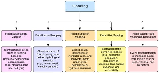
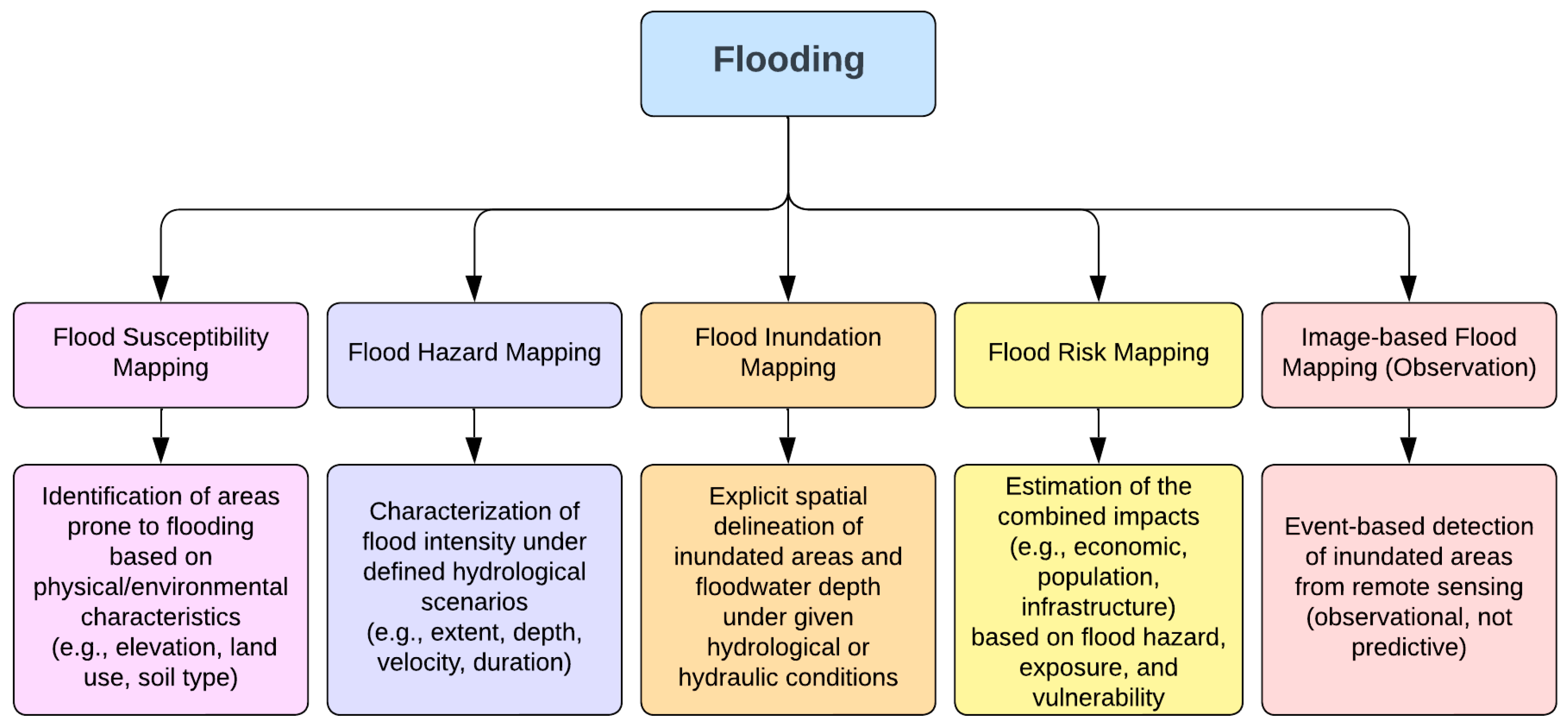
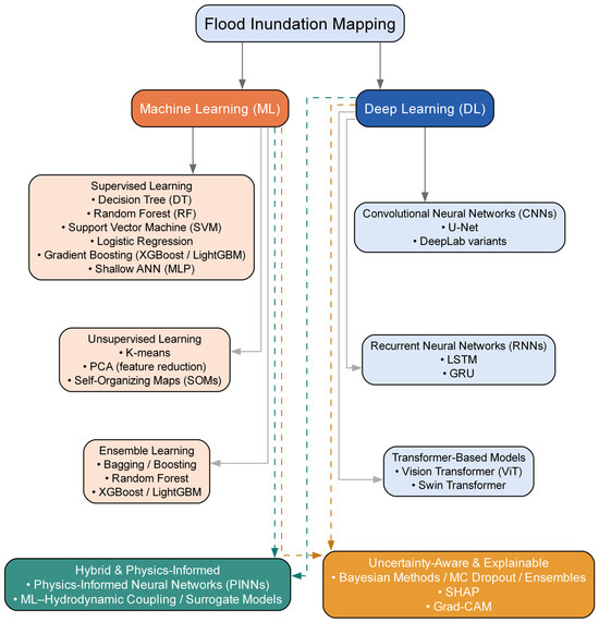
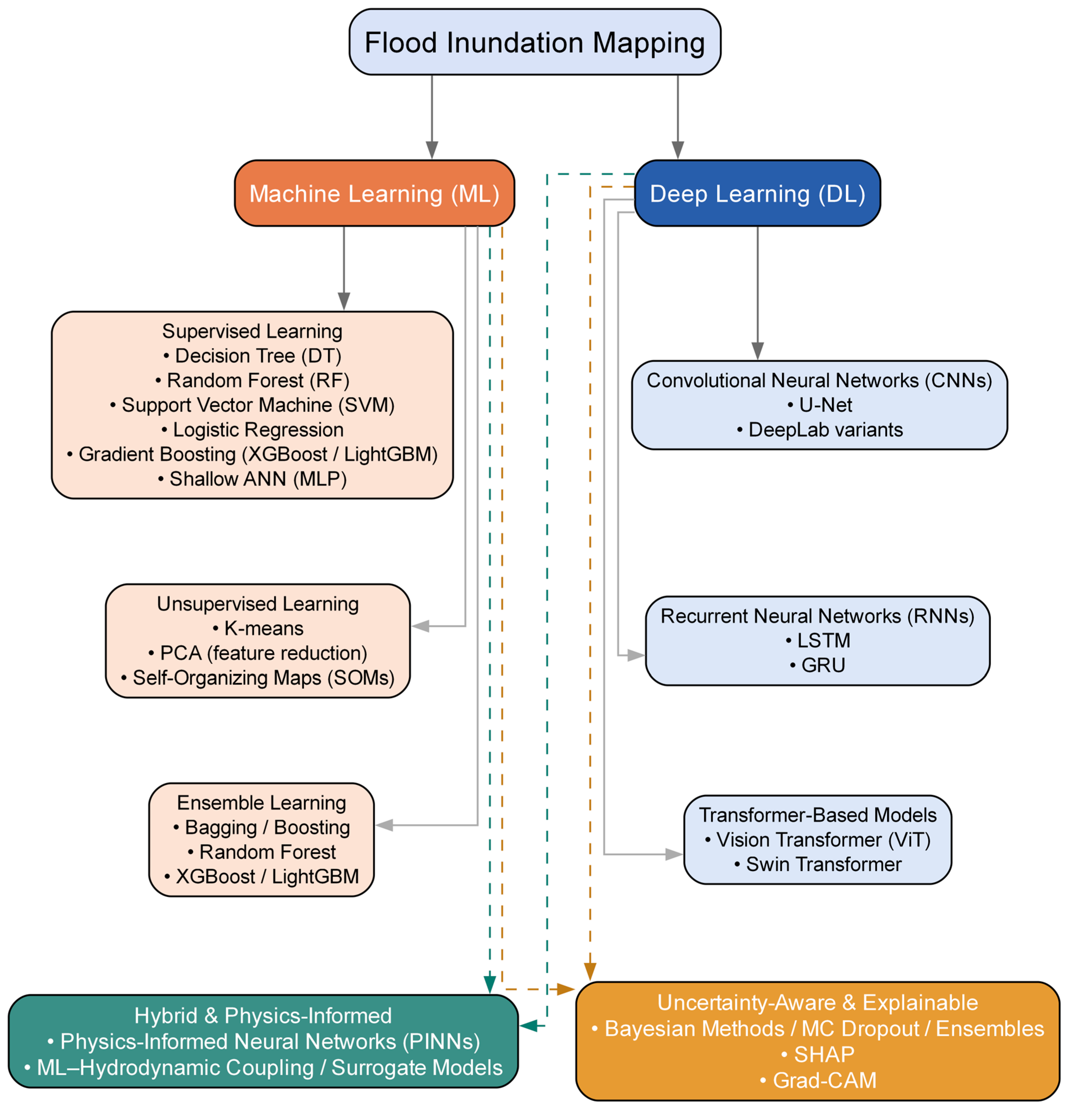
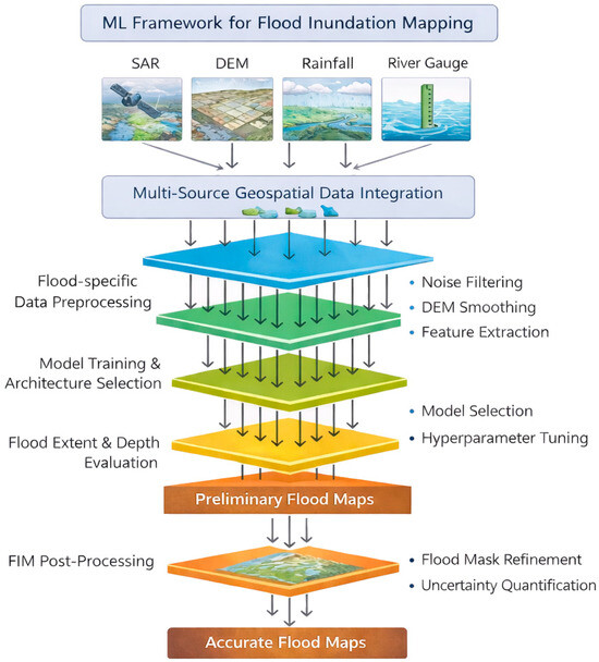
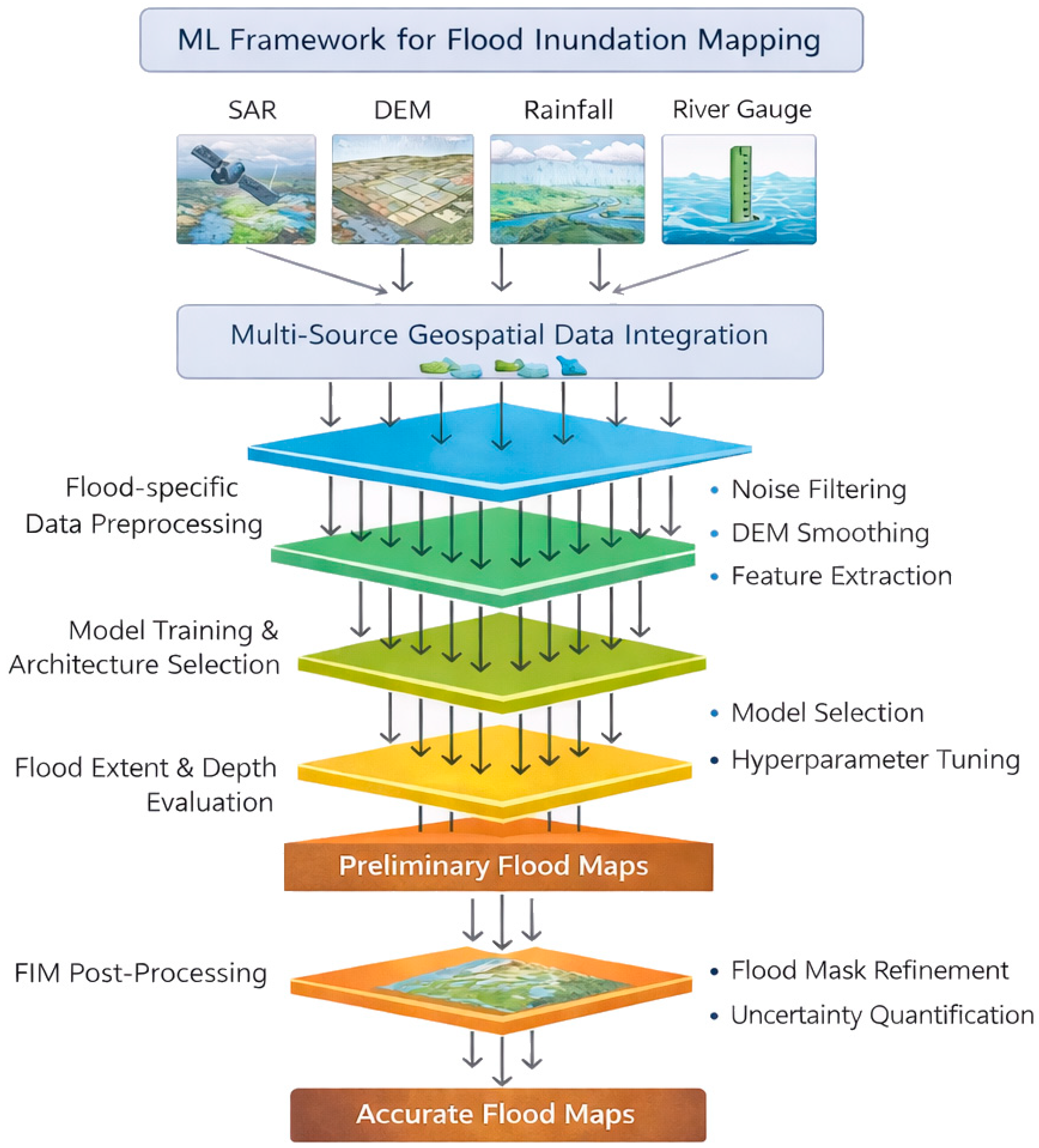
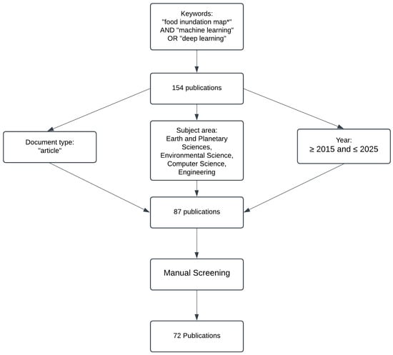
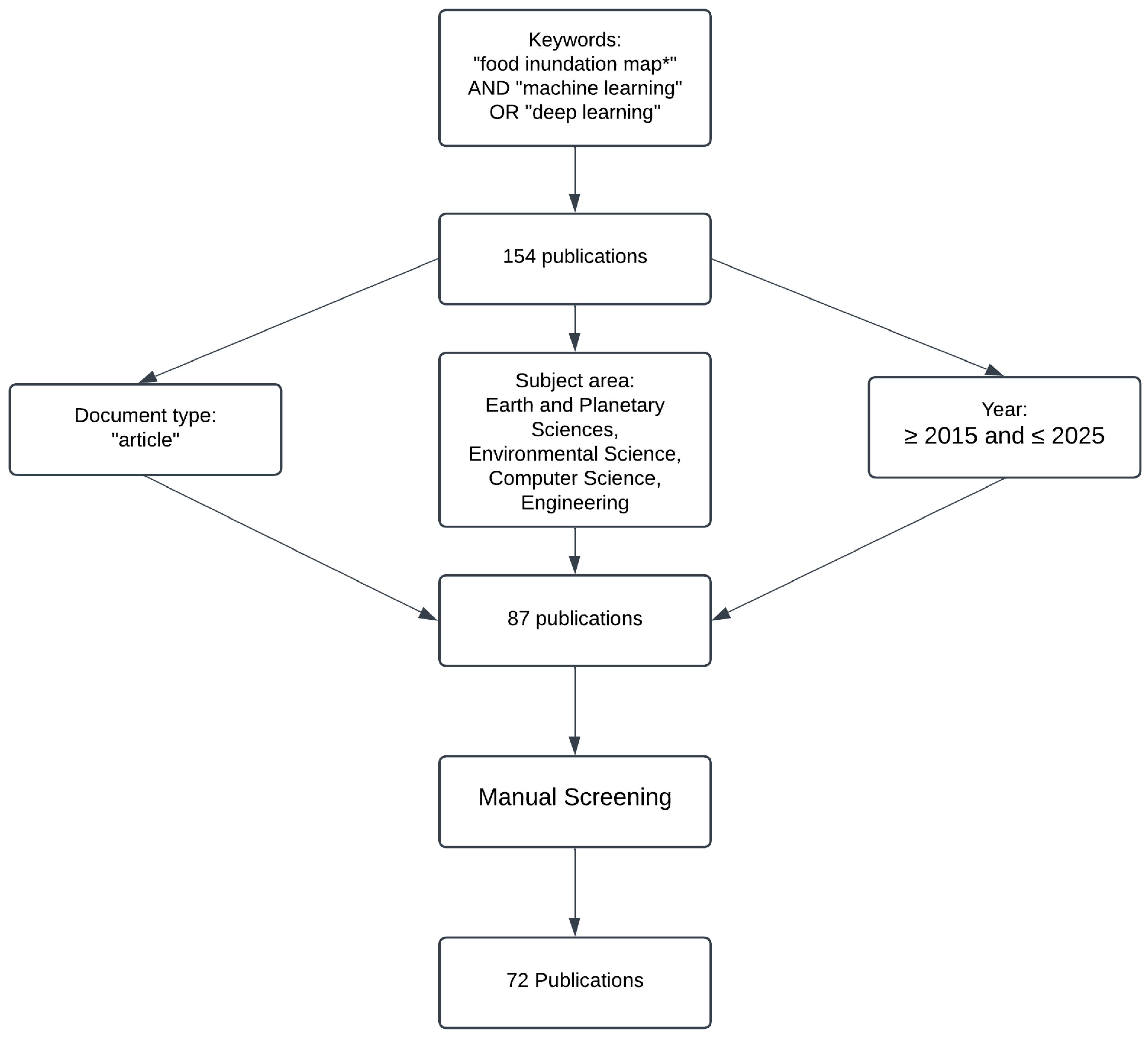
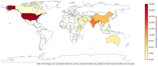
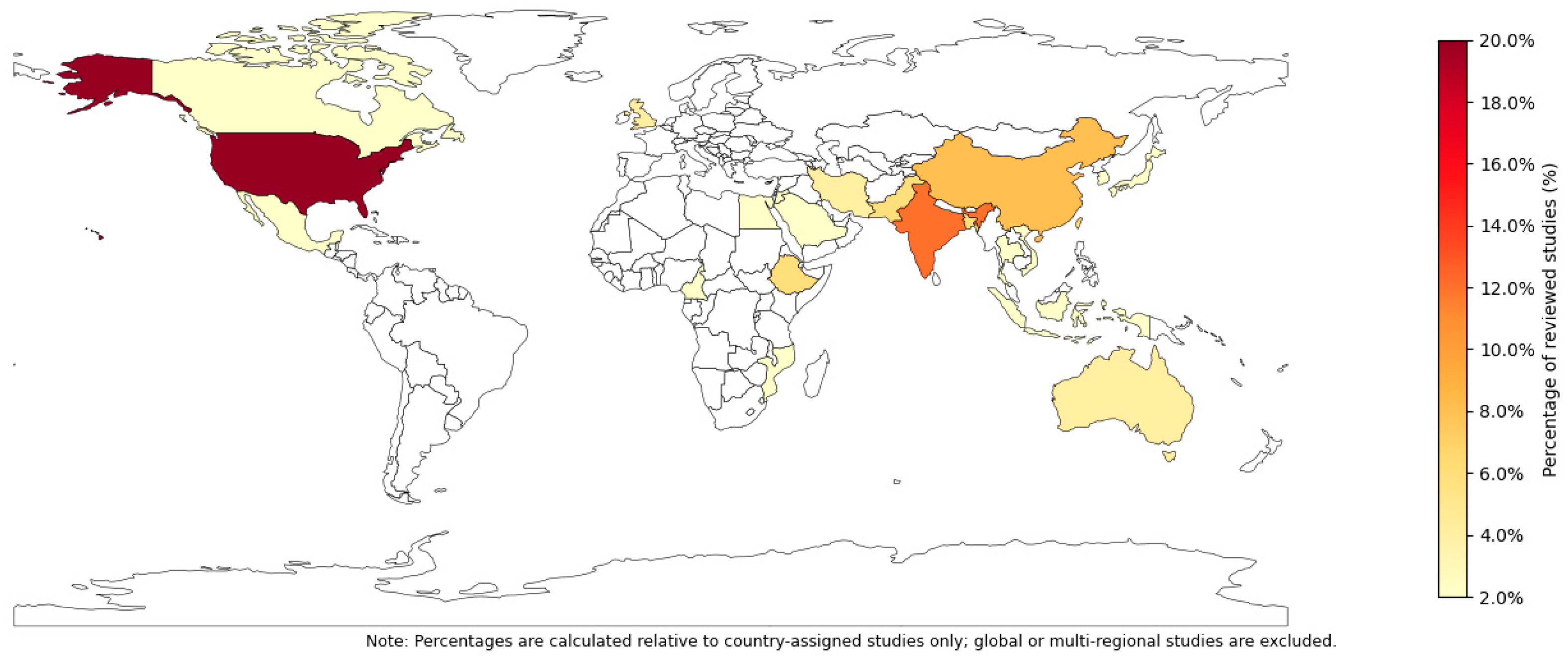
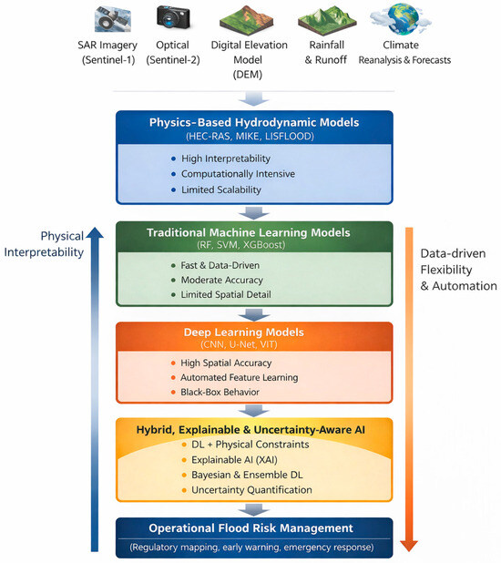
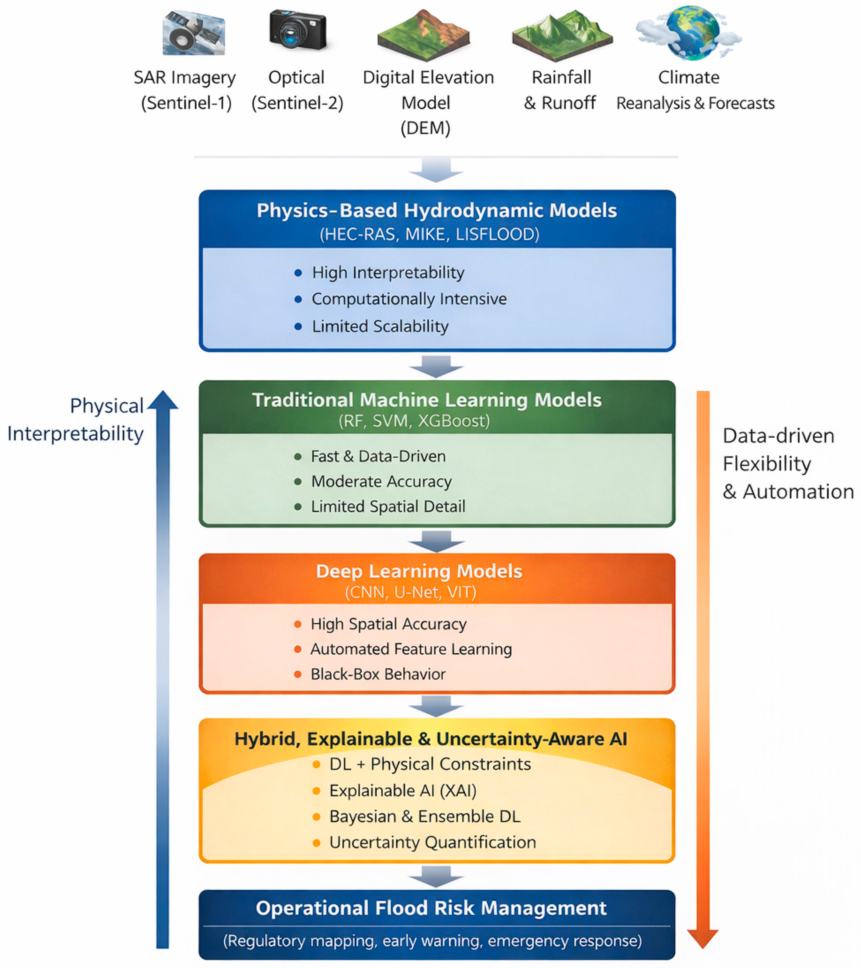

Disclaimer/Publisher’s Note: The statements, opinions and data contained in all publications are solely those of the individual author(s) and contributor(s) and not of MDPI and/or the editor(s). MDPI and/or the editor(s) disclaim responsibility for any injury to people or property resulting from any ideas, methods, instructions or products referred to in the content. |
© 2026 by the authors. Licensee MDPI, Basel, Switzerland. This article is an open access article distributed under the terms and conditions of the Creative Commons Attribution (CC BY) license.