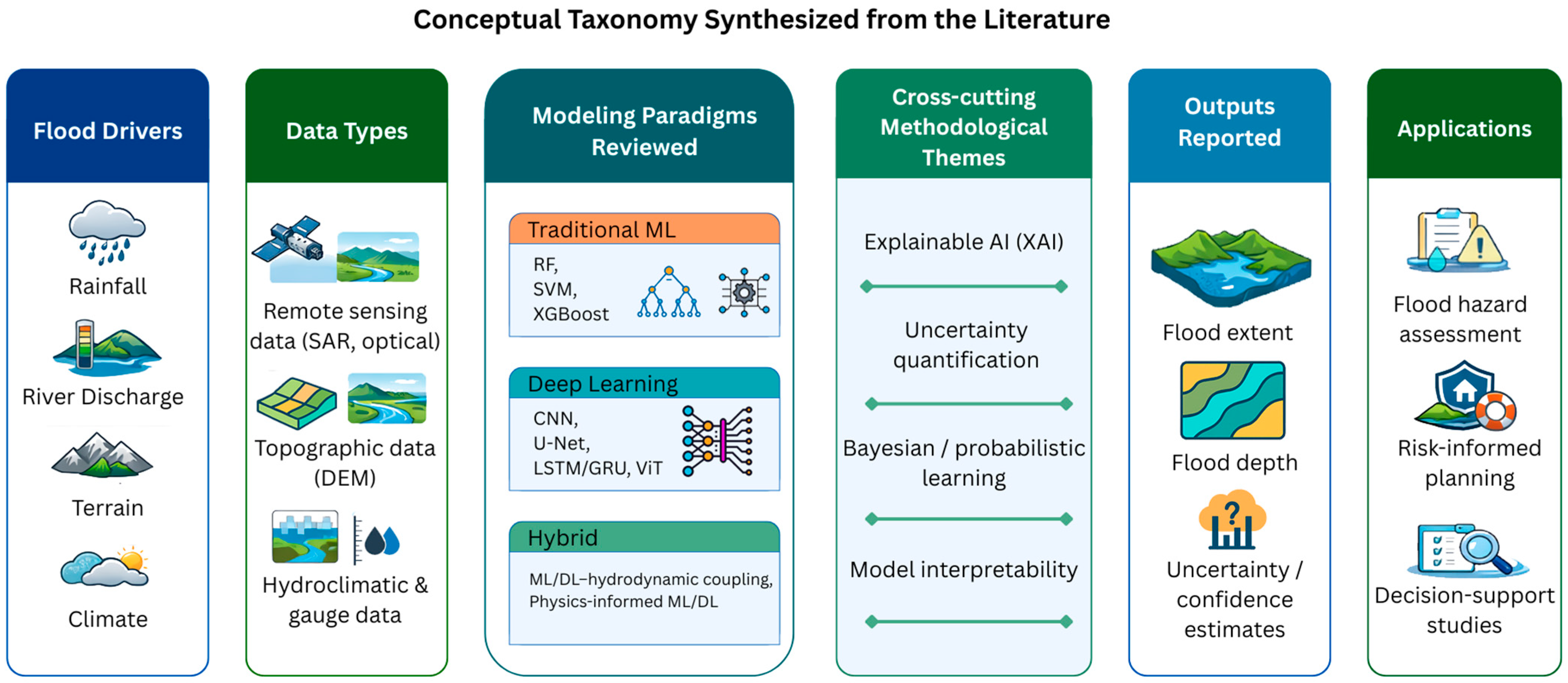
A Comprehensive Review of Machine Learning and Deep Learning Methods for Flood Inundation Mapping

 ,
, 
 , and
, and 
Abstract
1. Introduction
2. Conceptual Foundations of Flood Inundation Mapping
2.1. Flooding as a Spatial–Hydrological Phenomenon
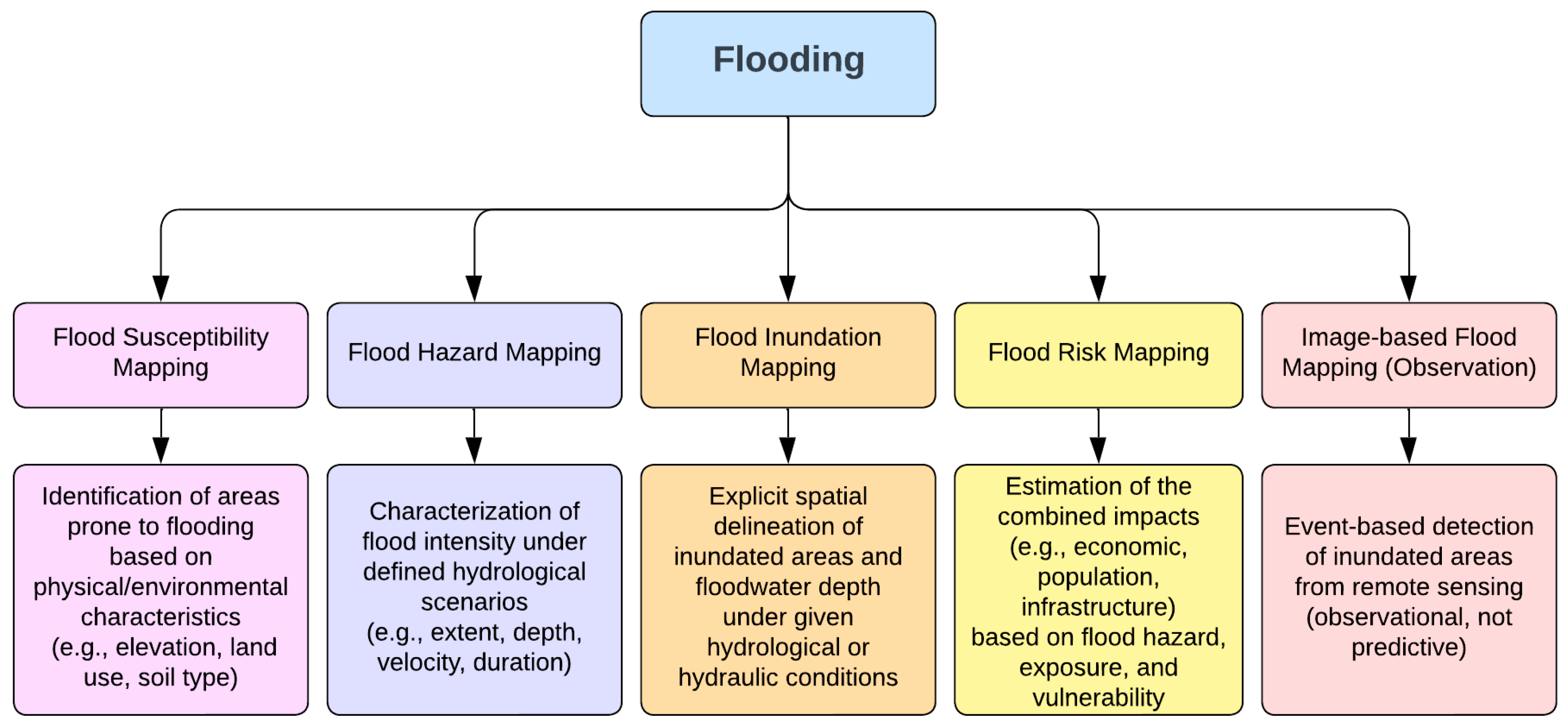
2.2. Flood Susceptibility Mapping
2.3. Flood Hazard Mapping
2.4. Flood Risk Mapping
2.5. Flood Inundation Mapping
2.6. Image-Based Flood Observation Versus Flood Inundation Mapping
2.7. Scope of This Review
3. Machine Learning and Deep Learning Methods
3.1. Traditional Machine Learning Approaches
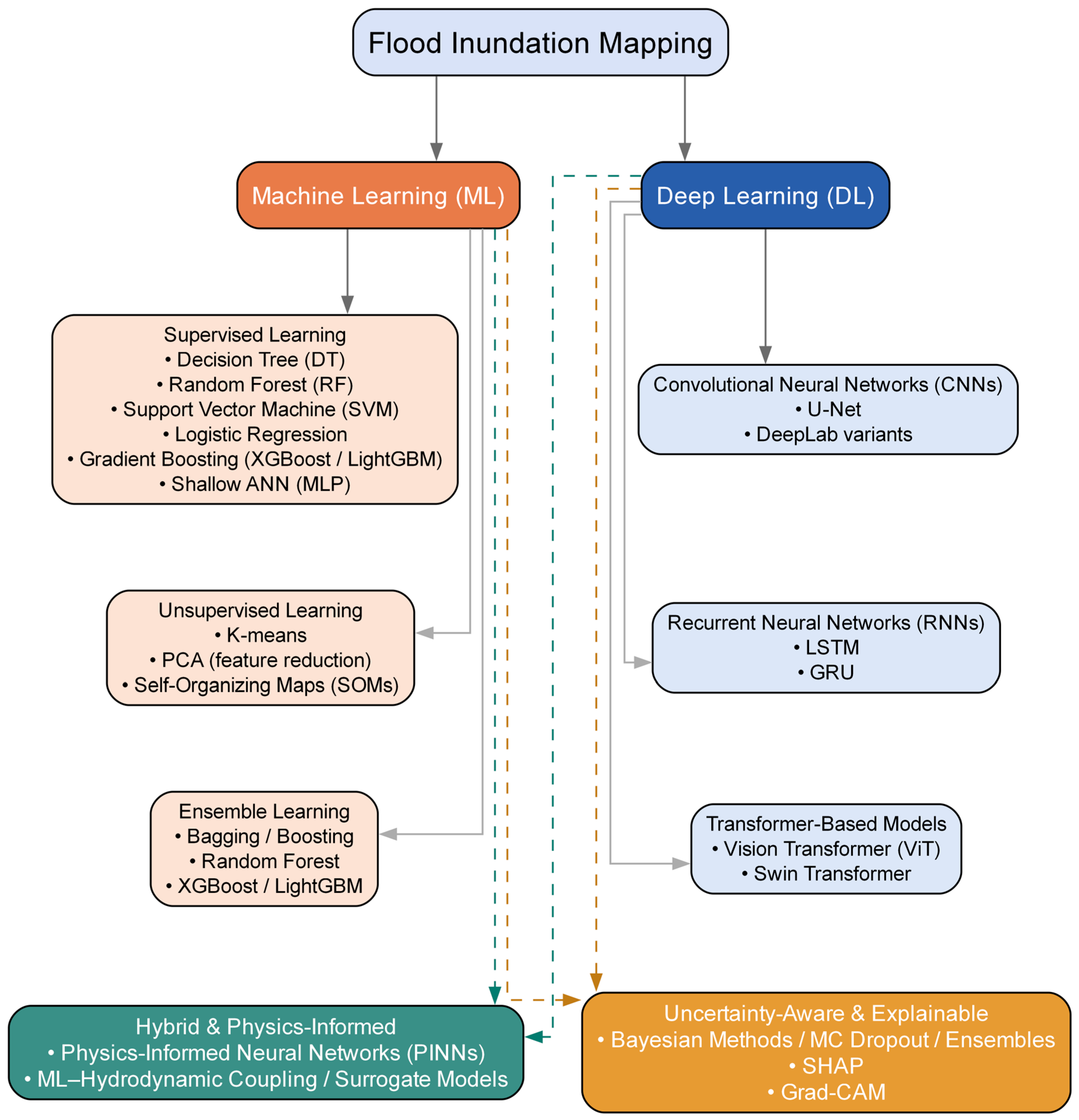
- Supervised learning, where models are trained using labeled flood and non-flood samples, is the most widely applied paradigm in flood studies. Common supervised algorithms include Decision Trees, Random Forest (RF), Support Vector Machines (SVM), logistic regression, gradient boosting models such as XGBoost and LightGBM, and shallow Artificial Neural Networks [20,21,43]. These methods are widely used for flood susceptibility classification and, less frequently, for regression-based flood depth estimation.
- Unsupervised learning methods aim to identify patterns or structures in data without labeled outputs. Techniques such as K-means clustering, Principal Component Analysis (PCA), and Self-Organizing Maps (SOMs) have been applied for dimensionality reduction, feature extraction, and exploratory flood pattern analysis [58,59]. While it is less common for direct flood mapping, unsupervised methods are often used as supporting tools in preprocessing or hybrid frameworks.
- Ensemble learning constitutes a particularly important subset of traditional ML in flood modeling. Ensemble methods combine multiple base learners to improve predictive robustness and reduce overfitting. Random Forest aggregates predictions from multiple decision trees trained on bootstrapped samples, while boosting methods such as AdaBoost, XGBoost, and LightGBM iteratively improve weak learners by emphasizing misclassified samples [60,61]. Ensemble models have consistently demonstrated strong performance in flood susceptibility and hazard mapping due to their ability to handle nonlinear relationships and heterogeneous geospatial datasets [14,45].
3.2. Deep Learning Approaches
3.3. Hybrid, Physics-Informed, Explainable, and Uncertainty-Aware Models
3.3.1. Hybrid and Physics-Informed Machine Learning Models
3.3.2. Uncertainty-Aware Flood Inundation Mapping
3.3.3. Explainable Artificial Intelligence in Flood Mapping
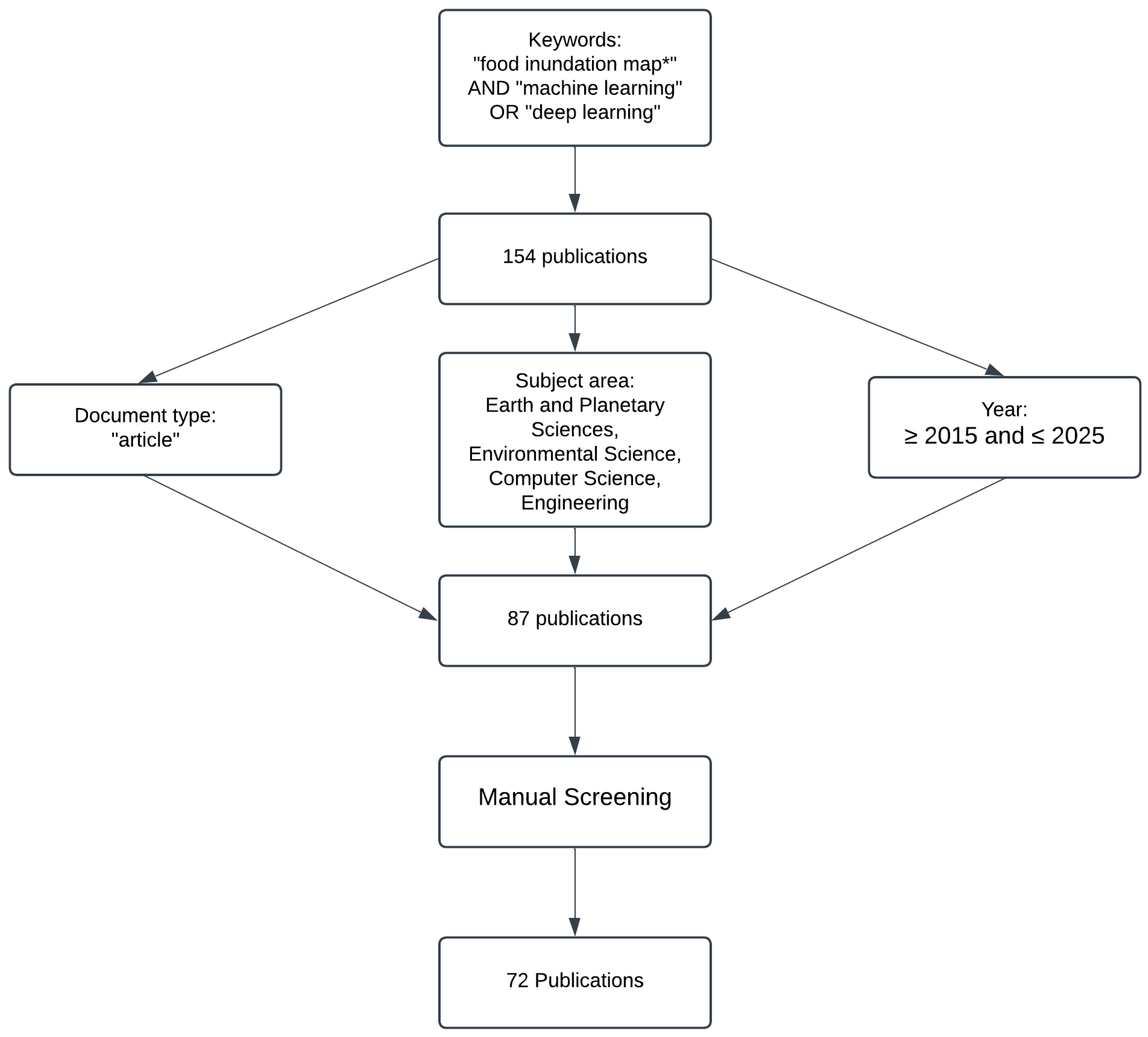
4. Review Methodology
5. Overview of ML Methods for FIMs
5.1. Traditional Machine Learning Based FIMs
5.2. Deep Learning-Based FIMs
Addressing Class Imbalance in Deep Learning-Based Flood Mapping
6. Performance Metrics & Benchmarking
6.1. Performance Metrics for Evaluating Flood Inundation Models
- Classification of flood-prone and non-flood-prone areas, including flood susceptibility and flood extent delineation
- Regression-based estimation of flood depth, expressed in continuous water level values
6.1.1. Classification-Based Evaluation for Flood Susceptibility and Extent Mapping
- Overall Accuracy (OA): Measures the proportion of correctly classified flood and non-flood pixels relative to the total dataset.
- Precision (Positive Predictive Value, PPV): Evaluates the percentage of areas predicted as flooded that were actually flooded, minimizing false positives.
- Recall (Sensitivity, True Positive Rate, TPR): Captures the proportion of actual flooded areas that were correctly identified.
- F1-Score: Provides a balanced measure of precision and recall, ensuring that neither false positives nor false negatives dominate model performance.
- Intersection over Union (IoU): Assesses the overlap between the predicted and actual flood extent, providing a measure of spatial agreement.
- Critical Success Index (CSI): Measures the ratio of correctly predicted flooded pixels to the union of observed and predicted flooded pixels and is widely used in operational flood inundation mapping to balance misses and false alarms.
- Probability of Detection (POD): Quantifies the fraction of observed flooded pixels correctly identified, emphasizing missed flooding.
- False Alarm Ratio (FAR): Measures the proportion of predicted flooded pixels that were false positives, which is critical for emergency response and evacuation planning.
- Receiver Operating Characteristic—Area Under the Curve (AUC-ROC): Determines the model’s ability to distinguish between flooded and non-flooded pixels across different threshold settings.
6.1.2. Regression-Based Evaluation for Flood Depth Estimation
- Root Mean Squared Error (RMSE): Measures the deviation of predicted flood depths from observed values, penalizing larger errors.
- Mean Absolute Error (MAE): Captures the average absolute difference between predicted and actual flood depths.
- Coefficient of Determination (R2): Quantifies the proportion of variance in flood depth explained by the model.
- Mean Squared Error (MSE): Similarly to RMSE but more sensitive to larger errors.
6.2. Comparative Benchmarking of ML Models for FIM
6.2.1. Comparison of Flood Extent Mapping Models
6.2.2. Comparison of Flood Depth Estimation Models
6.2.3. Model Benchmarking Summary
7. Discussion
7.1. Synergies and Trade-Offs Between Machine Learning and FEMA’s Process-Based Models
- Addressing Data Gaps: In regions where detailed hydraulic models are unavailable, ML-based flood mapping fills the gap by learning patterns from historical flood events and terrain features [21].
7.2. Challenges in ML-Based Flood Inundation Mapping
7.2.1. The Black Box Problem and Model Transparency
7.2.2. Data Availability, Bias, and Generalization Issues
7.2.3. Regulatory Barriers and Lack of Standardization
7.3. Future Directions for ML-Based Flood Mapping
7.3.1. Hybrid Physics-Informed ML Models
7.3.2. Explainable and Uncertainty-Aware Flood Models
7.3.3. Satellite–AI Fusion for Near-Real-Time Flood Mapping
7.3.4. Emerging Multimodal and AI-Driven Extensions
8. Conclusions
Author Contributions
Funding
Data Availability Statement
Acknowledgments
Conflicts of Interest
Appendix A

| SN | Title | Reference | Brief Description |
|---|---|---|---|
| 1 | A hybridized model based on neural network and swarm intelligence-grey wolf algorithm for spatial prediction of urban flood-inundation | [84] | A hybrid ANN-SGW model combines ANN with Swarm Intelligence and Grey Wolf Optimizer for urban flood inundation mapping in Sari City, Iran, demonstrating superior performance in predictive accuracy compared to traditional models. |
| 2 | Spatial-temporal flood inundation nowcasts by fusing machine learning methods and principal component analysis | [59] | A real-time forecasting system integrates PCA, SOM, and NARX for urban flood inundation in Taipei City, achieving improved forecasting accuracy and computational efficiency. |
| 3 | Near-real-time non-obstructed flood inundation mapping using synthetic aperture radar | [102] | RAPID uses SAR data for rapid flood inundation mapping, achieving 93% accuracy during events like Typhoon Nepartak and Hurricane Harvey. |
| 4 | Mapping floods from remote sensing data and quantifying the effects of surface obstruction by clouds and vegetation | [103] | A CNN-based DELTA framework maps floods using multispectral imagery, addressing underprediction caused by clouds and vegetation with significant |
| 5 | Development of a spatially complete floodplain map of the conterminous United States using random forest | [14] | Random Forest technology develops comprehensive floodplain maps across the CONUS, matching 79% of FEMA’s designated flood areas. |
| 6 | Resilient landscape pattern for reducing coastal flood susceptibility | [104] | Neural network models assess and plan urban spaces for improved flood resilience using landscape metrics, highlighting key metrics like core area and proximity indices. |
| 7 | Automated Flood Water Depth Estimation Using Large Multimodal Model for Rapid Flood Mapping | [100] | A novel automated method employs GPT-4 Vision to estimate flood water depth from on-site flood photos, enhancing the speed and accuracy of flood mapping. |
| 8 | Evaluation of Flood Susceptibility in Douala Estuary Cameroon using GIS, Remote Sensing and Logistic Regression | [41] | GIS and logistic regression evaluate flood susceptibility in Douala, Cameroon, categorizing areas based on their susceptibility with high accuracy. |
| 9 | Flood susceptibility modeling using advanced ensemble machine learning models | [20] | Ensemble ML techniques model flood susceptibility in the Teesta River basin, Bangladesh, with Dagging models showing the best performance. |
| 10 | U-net-based semantic classification for flood extent extraction using SAR imagery and GEE platform: A case study for 2019 central US flooding | [25] | A modified U-Net model extracts flood extent from SAR imagery during the 2019 Central US flooding, achieving superior performance in identifying flood regions. |
| 11 | A novel multi-model ensemble framework for fluvial flood inundation mapping | [21] | A multi-model ensemble framework enhances flood prediction accuracy by combining various ML models, achieving high accuracy and computational efficiency. |
| 12 | Advanced Techniques of Flood Forecasting, Flood Inundation Mapping and Flood Prioritization of Panam River Basin | [31] | Neural networks and fuzzy logic enhance flood forecasting and inundation mapping in the Panam River Basin. |
| 13 | Exploring Sentinel-1 and Sentinel-2 diversity for flood inundation mapping using deep learning | [24] | The combined use of Sentinel-1 SAR and Sentinel-2 multispectral imagery improves flood mapping accuracy using deep learning techniques. |
| 14 | Rainfall-driven machine learning models for accurate flood inundation mapping in Karachi, Pakistan | [105] | ML models integrate rainfall data with urban and environmental factors to enhance flood prediction in Karachi, with Light Gradient Boost Machine and RF showing top performance. |
| 15 | Flood risk evaluation of the coastal city by the EWM-TOPSIS and machine learning hybrid method | [106] | A hybrid method of EWM-TOPSIS and multi-class neural networks enhances flood risk evaluation in coastal cities, identifying high-risk flood areas with improved accuracy. |
| 16 | Supervised and unsupervised machine learning approaches using Sentinel data for flood mapping and damage assessment in Mozambique | [107] | Supervised and unsupervised ML methods using Sentinel-1 and Sentinel-2 data map floods and assess damage in Beira, Mozambique. |
| 17 | Development of a spatial framework for flash flood damage assessment and mitigation by coupling analytics of machine learning and household level survey data—A case study of rapid collaborative assessments and disbursement of public funds to the affectees of floods 2022, Punjab Pakistan. | [79] | ML and household surveys develop a spatial framework for rapid assessment and mitigation of flash flood damages in Punjab, Pakistan, facilitating efficient disbursement of relief funds. |
| 18 | Application of ANN and HEC-RAS model for flood inundation mapping in lower Baro Akobo River Basin, Ethiopia | [64] | ANN and HEC-RAS models map flood inundation in the lower Baro Akobo River Basin, Ethiopia, improving the accuracy of flood prediction and mapping. |
| 19 | Stormwater Management Modeling and Machine Learning for Flash Flood Susceptibility Prediction in Wadi Qows, Saudi Arabia | [56] | ML models assess flash flood-prone areas and compare effectiveness against the PCSWMM for disaster management in Wadi Qows, Saudi Arabia. |
| 20 | Improving Interpretability of Deep Active Learning for Flood Inundation Mapping Through Class Ambiguity Indices Using Multi-spectral Satellite Imagery | [91] | Deep active learning strategies in flood inundation mapping use multi-spectral satellite imagery to improve interpretability through class ambiguity indices. |
| 21 | Explainable Deep Semantic Segmentation for Flood Inundation Mapping with Class Activation Mapping Techniques | [32] | An interpretable deep learning model for flood inundation mapping uses CAM to highlight significant regions influencing model decisions. |
| 22 | A Hidden Markov Forest Model for Terrain-Aware Flood Inundation Mapping from Earth Imagery | [86] | A Hidden Markov Forest Model incorporates terrain information into a machine learning framework to enhance flood inundation mapping accuracy, reduce computational demands, and increase scalability. |
| 23 | Simulating flood risk in Tampa Bay using a machine learning driven approach | [74] | ML models identify critical non-linear relationships between flood damage locations and flood risk factors in Tampa Bay, Florida. |
| 24 | Attentive Dual Stream Siamese U-Net for Flood Detection on Multi-Temporal Sentinel-1 Data | [90] | A new deep learning architecture detects floods using bi-temporal SAR data from Sentinel-1, enhancing accuracy in flood mapping. |
| 25 | Application of LSTMs and HAND in Rapid Flood Inundation Mapping | [26] | LSTM networks and HAND combine in a hybrid flood prediction model for rapid and real-time flood inundation mapping. |
| 26 | Combining Deep Learning and Numerical Simulation to Predict Flood Inundation Depth | [33] | CNN models and physics-based numerical simulations integrate to predict flood inundation depths, leveraging both machine learning and traditional hydrodynamic modeling techniques. |
| 27 | Advanced machine learning algorithms for flood susceptibility modeling—performance comparison: Red Sea, Egypt | [108] | Seven different ML algorithms compare for flood susceptibility modeling in the Red Sea, Egypt, with Random Forest outperforming others. |
| 28 | Enhancing Flood Risk Assessment through Integration of Ensemble Learning Approaches and Physical-Based Hydrological Modeling | [45] | Ensemble ML techniques and traditional physical-based hydrological modeling integrated to enhance flood risk assessment in the Vietnamese Vu Gia-Thu Bon river basin. |
| 29 | Flood Inundation Mapping with Limited Observations Based on Physics-Aware Topography Constraint | [109] | An innovative approach for flood inundation mapping utilizes a limited number of observational data points, incorporating physics-aware structural constraints based on topographical data. |
| 30 | Flooded Areas Detection through SAR Images and U-NET Deep Learning Model | [78] | A deep learning model using U-NET architecture detects and monitors flood areas using SAR images from Sentinel-1 satellites in the Ríos region of Tabasco, Mexico. |
| 31 | Rapid Flood Mapping Using Multi-temporal SAR Images: An Example from Bangladesh | [18] | Multi-temporal SAR images are utilized for rapid flood mapping during frequent flood events in Bangladesh. |
| 32 | Optimal Fusion of Multispectral Optical and SAR Images for Flood Inundation Mapping through Explainable Deep Learning | [93] | A deep learning architecture fuses multispectral optical and SAR images for precise flood inundation mapping, incorporating Explainable AI for improved interpretability. |
| 33 | A Machine Learning Approach for Forecasting and Visualizing Flood Inundation Information | [95] | A machine learning-based framework forecasts and visualizes flood inundation in real-time, providing a faster alternative to traditional hydrodynamic models. |
| 34 | Near Real-time Flood Inundation and Hazard Mapping of Baitarani River Basin using Google Earth Engine and SAR Imagery | [110] | Sentinel-1 SAR imagery and Google Earth Engine facilitate near real-time flood inundation and hazard mapping in the Baitarani River Basin, India. |
| 35 | Detection of Flood Extent Using Sentinel-1A/B Synthetic Aperture Radar: An Application for Hurricane Harvey, Houston, TX | [49] | Different methodologies are evaluated for characterizing flood inundation using SAR data from Sentinel-1A/B during Hurricane Harvey in Houston, TX. |
| 36 | Reducing the Computational Cost of Urban Flood Prediction in Los Angeles | [92] | An urban-aware, low-cost deep learning flood prediction model is developed for Bell Gardens and Downey in Los Angeles County, reducing computational demands while providing accurate real-time flood mapping. |
| 37 | Enhancement of Detecting Permanent Water and Temporary Water in Flood Disasters by Fusing Sentinel-1 and Sentinel-2 Imagery Using Deep Learning Algorithms | [23] | The detection of permanent and temporary water bodies during flood events is enhanced by fusing Sentinel-1 SAR and Sentinel-2 optical imagery using deep learning techniques, leveraging the Sen1Floods11 datasets. |
| 38 | Development of an Automated Method for Flood Inundation Monitoring, Flood Hazard, and Soil Erosion Susceptibility Assessment Using Machine Learning and AHP–MCE Techniques | [42] | Machine learning algorithms and AHP-MCE techniques are used to develop an automated method for monitoring flood inundation and assessing flood hazards and soil erosion susceptibility in Assam State, India. |
| 39 | Machine-learning and HEC-RAS Integrated Models for Flood Inundation Mapping in Baro River Basin, Ethiopia | [44] | Machine-learning and HEC-RAS models are integrated for flood inundation mapping in the Baro River Basin, Ethiopia, enhancing accuracy and reducing uncertainties in flood forecasting. |
| 40 | Predicting Flood Inundation Extent Using Remote Sensing and Machine Learning Techniques | [83] | Machine learning and remote sensing are combined to predict flood inundation extent, assessing the impact of climate change on flood inundation in the Macintyre River catchment in Australia. |
| 41 | A rapid flood inundation modelling framework using deep learning with spatial reduction and reconstruction | [111] | A Spatial Reduction and Reconstruction–LSTM framework simulates Burnett River flood inundation in seconds while closely matching a 2D hydrodynamic model, greatly reducing computational cost with minimal loss of accuracy. |
| 42 | DeepSARFlood: Rapid and automated SAR-based flood inundation mapping using vision transformer-based deep ensembles with uncertainty estimates | [28] | DeepSARFlood: A ViT–CNN deep ensemble framework automates SAR-based flood mapping in a cloud platform, achieving state-of-the-art accuracy (IoU ≈ 0.72) with uncertainty-aware outputs for rapid operational flood response. |
| 43 | A Novel Deep Learning Model for Flood Detection from Synthetic Aperture Radar Images | [29] | A Swin-Transformer-based Siamese network (S1GFloods) uses bi-temporal Sentinel-1 SAR images and multi-level change detection to map flooded areas, outperforming CNN and Transformer baselines with high accuracy and reduced computational cost. |
| 44 | Deep learning-based flood inundation prediction in the Pattani River Basin | [94] | A hybrid deep learning framework integrates GRU-based water level forecasting with CNN-based Sentinel-1 SAR classification to predict flood inundation in Thailand’s Pattani River Basin, outperforming LSTM and threshold-based methods in accuracy |
| 45 | Impacts of DEM Type and Resolution on Deep Learning-Based Flood Inundation Mapping | [88] | Different types and resolutions of DEMs affect the accuracy of flood prediction using deep learning techniques, specifically a 1D CNN. |
| 46 | Hybrid Surrogate Model for Timely Prediction of Flash Flood Inundation Maps Caused by Rapid River Overflow | [101] | A hybrid surrogate model combines ML techniques with physically based hydraulic models to rapidly predict flash flood inundation maps, particularly designed for urban areas. |
| 47 | Probabilistic Forecasts of Flood Inundation Maps Using Surrogate Models | [34] | Surrogate models generate probabilistic flood inundation maps to enhance flood early warning systems. |
| 48 | Inundation Map Prediction with Rainfall Return Period and Machine Learning | [73] | A PNN–SVR–SOM framework predicts rainfall return periods, flood volume, and urban inundation maps in Seoul’s Gangnam District, reproducing 2D model flood extents with about 86% accuracy and enabling real-time flood management applications. |
| 49 | Creating Sustainable Flood Maps Using Machine Learning and Free Remote Sensing Data in Unmapped Areas | [80] | A random forest regression model generates flood inundation maps for FEMA-unmapped areas using elevation, land use, soil data, and historical floods, accurately predicting flood extents and demonstrating machine learning’s potential to complement or replace traditional floodplain mapping. |
| 50 | Quantification of Continuous Flood Hazard Using Random Forest Classification and Flood Insurance Claims at Large Spatial Scales | [13] | A random forest-based flood hazard model uses 40 years of NFIP claims and high-resolution geospatial data to map continuous flood risk across southeast Texas, revealing roughly three times more at-risk structures than indicated by FEMA’s existing floodplain maps. |
| 51 | Flood Detection with SAR: A Review of Techniques and Datasets | [16] | Techniques for flood detection using Synthetic Aperture Radar (SAR) are comprehensively reviewed, discussing challenges and advancements in SAR technology and methodologies. |
| 52 | Improving Flood Hazard Susceptibility Assessment by Integrating Hydrodynamic Modeling with Remote Sensing and Ensemble Machine Learning | [81] | An integrated HEC-RAS–RF–XGBoost framework maps flood susceptibility in Pakistan’s mountainous Hunza-Nagar region by combining 100-year hydrodynamic simulations with 10 geo-environmental factors, with Random Forest achieving the highest accuracy for identifying high-risk zones. |
| 53 | Integrating Machine Learning and Geospatial Data Analysis for Comprehensive Flood Hazard Assessment | [72] | Advanced machine learning frameworks are developed for comprehensive flood hazard assessment in the Arambag region of West Bengal, India, integrating multiple flood conditioning factors. |
| 54 | A Novel Hybrid Artificial Intelligence Approach for Flood Susceptibility Assessment | [85] | A novel AI model, Bagging-LMT, is introduced for flood susceptibility mapping in the Haraz watershed, Iran, demonstrating superior performance compared to traditional models. |
| 55 | The Utilization of Satellite Data and Machine Learning for Predicting the Inundation Height in the Majalaya Watershed | [68] | Satellite data and machine learning are utilized to predict the inundation height across the Majalaya Watershed, Indonesia, enhancing flood risk management. |
| 56 | Long-Term Flooding Maps Forecasting System Using Series Machine Learning and Numerical Weather Prediction System | [112] | Machine learning techniques integrated with numerical weather prediction systems develop a forecasting system for long-term flooding maps, providing accurate real-time forecasts of inundation depth and area during typhoon events. |
| 57 | Building an Intelligent Hydroinformatics Integration Platform for Regional Flood Inundation Warning Systems | [113] | An Intelligent Hydroinformatics Integration Platform is developed to enhance regional flood inundation warning systems, integrating machine learning, data visualization, and system development techniques. |
| 58 | Rapid and large-scale mapping of flood inundation via integrating spaceborne synthetic aperture radar imagery with unsupervised deep learning | [89] | An unsupervised Felz-CNN model on Sentinel-1 SAR data uses super-pixel segmentation and CNN features to rapidly map large-scale floods achieving over 93% accuracy and outperforming traditional supervised and threshold-based methods. |
| 59 | A space and time framework for analyzing human anticipation of flash floods | [114] | A study investigates the temporal and spatial dynamics of human anticipation and response to flash floods to enhance risk management strategies. |
| 60 | High-Resolution Inundation Mapping for Heterogeneous Land Covers with Synthetic Aperture Radar and Terrain Data | [115] | Flood inundation mapping accuracy is enhanced in regions with heterogeneous land covers using Sentinel-1A C-Band SAR data and HAND, evaluated through machine learning techniques. |
| 61 | Scalable Flood Inundation Mapping Using Deep Convolutional Networks and Traffic Signage | [87] | Deep convolutional neural networks and crowdsourced photos of submerged traffic signs enhance flood depth estimation and mapping, providing a scalable and efficient solution for real-time flood depth estimation. |
| 62 | Predicting synthetic rating curve adjustment factors with explainable machine learning for enhancing the United States operational flood inundation mapping framework | [75] | An explainable tree-based ML framework (XGB, RF) predicts SRC adjustment factors for NOAA’s HAND-FIM across CONUS, improving national-scale flood extent accuracy and flooded-asset detection in ungauged river reaches. |
| 63 | Enhancing flood prediction in Southern West Bengal, India using ensemble machine learning models optimized with symbiotic organisms search algorithm | [116] | An SOS-optimized ensemble of SVM, ANN, decision tree, and Naïve Bayes classifiers produces very high-AUC flood-susceptibility maps for southern West Bengal, highlighting terrain, drainage, and soil controls in data-scarce deltaic settings. |
| 64 | Improving the fidelity and performance of a conceptual flood inundation mapping approach using a machine learning-based surrogate model | [76] | A ML surrogate trained on HAND-FIM and 2D HEC-RAS outputs corrects conceptual HAND flood maps, cutting false alarms and boosting CSI while remaining computationally efficient for large-scale operational forecasting. |
| 65 | Deep Neural Networks Hydrologic and Hydraulic Modeling in Flood Hazard Analysis | [117] | A hybrid SCS-CN/IDF-based HEC-HMS–HEC-RAS framework coupled with a DNN runoff predictor quantifies 50- and 100-year flash-flood depths and inundation in Wadi Al Wala, supporting flood-hazard assessment in a data-sparse arid basin. |
| 66 | Generalized methodology for two-dimensional flood depth prediction using ML-based models | [77] | A clustered Random Forest surrogate trained on global HEC-RAS 2D simulations and open geospatial data rapidly emulates flood-depth fields worldwide, achieving strong accuracy and ~225× speed-up for near-real-time early warning in ungauged catchments. |
| 67 | Flood inundation mapping of a river stretch using machine learning algorithms in the Google Earth Engine environment | [97] | Sentinel-1 SAR with GEE-based supervised classifiers, especially RF and SVM, generates accurate flood-extent maps for the Godavari River reach, clearly outperforming Otsu thresholding and enabling LULC-based impact assessment. |
| 68 | Rapid Flood Inundation Mapping for Effective Management: A Machine Learning and Pixel-Based Classification Approach in Feni District, Bangladesh | [82] | Pixel-based SAR thresholding and RF on Sentinel-1 in GEE deliver rapid, high-accuracy inundation maps for the 2024 Feni flash flood, supporting operational response, exposure analysis, and multi-year flood recurrence studies. |
| 69 | Mapping flood inundation in Baro Akobo Basin, Itang area, Ethiopia: integrating machine learning and process-based models | [118] | A hybrid HEC-HMS–ANN rainfall–runoff model linked to 2D HEC-RAS, validated against Landsat NDWI, generates highly accurate depth–extent flood maps for the lower Baro floodplain, informing hazard zoning and mitigation planning. |
| 70 | Riverine flood hazard map prediction by neural networks | [119] | A transformer-encoder plus Res-U-Net architecture emulates 2D HEC-RAS riverine flood depth maps from boundary hydrographs and geophysical layers, producing highly accurate hazard maps within seconds for hurricane-driven events. |
| 71 | Rapid flood inundation mapping by integrating deep learning-based image super-resolution with coarse-grid hydrodynamic modeling | [96] | A DenseUNet super-resolution network upsamples coarse shallow-water model outputs into fine-scale depth and velocity maps for the Shenzhen River, preserving hydrodynamic detail while achieving orders-of-magnitude faster flood mapping. |
| 72 | Uncertainty-Aware Flood Inundation Mapping With a Bayesian Deep Learning Framework Using SAR Imagery | [35] | A Bayesian U-Net applied to Sentinel-1 SAR produces probabilistic flood maps with calibrated spatial uncertainty, outperforming deterministic U-Net and enabling risk-aware, uncertainty-quantified inundation mapping for diverse floodplains. |
References
- Winsemius, H.C.; Aerts, J.C.J.H.; Van Beek, L.P.H.; Bierkens, M.F.P.; Bouwman, A.; Jongman, B.; Kwadijk, J.C.J.; Ligtvoet, W.; Lucas, P.L.; van Vuuren, D.P.; et al. Global Drivers of Future River Flood Risk. Nat. Clim. Chang. 2016, 6, 381–385. [Google Scholar] [CrossRef] [Scilit]
- Tellman, B.; Sullivan, J.A.; Kuhn, C.; Kettner, A.J.; Doyle, C.S.; Brakenridge, G.R.; Erickson, T.A.; Slayback, D.A. Satellite Imaging Reveals Increased Proportion of Population Exposed to Floods. Nature 2021, 596, 80–86. [Google Scholar] [CrossRef] [Scilit]
- Rindsfüser, N.; Zischg, A.P.; Keiler, M. Monitoring Flood Risk Evolution: A Systematic Review. iScience 2024, 27, 110653. [Google Scholar] [CrossRef] [Scilit]
- Hirabayashi, Y.; Mahendran, R.; Koirala, S.; Konoshima, L.; Yamazaki, D.; Watanabe, S.; Kim, H.; Kanae, S. Global Flood Risk under Climate Change. Nat. Clim. Chang. 2013, 3, 816–821. [Google Scholar] [CrossRef] [Scilit]
- Jongman, B.; Hochrainer-Stigler, S.; Feyen, L.; Aerts, J.C.J.H.; Mechler, R.; Botzen, W.J.W.; Bouwer, L.M.; Pflug, G.; Rojas, R.; Ward, P.J. Increasing Stress on Disaster-Risk Finance Due to Large Floods. Nat. Clim. Chang. 2014, 4, 264–268. [Google Scholar] [CrossRef] [Scilit]
- Dahal, D.; Bhattarai, N.; Silwal, A.; Shrestha, S.; Shrestha, B.; Poudel, B.; Kalra, A. A Review on Climate Change Impacts on Freshwater Systems and Ecosystem Resilience. Water 2025, 17, 3052. [Google Scholar] [CrossRef] [Scilit]
- Merz, B.; Hall, J.; Disse, M.; Schumann, A. Fluvial Flood Risk Management in a Changing World. Nat. Hazards Earth Syst. Sci. 2010, 10, 509–527. [Google Scholar] [CrossRef] [Scilit]
- Bates, P.D.; Quinn, N.; Sampson, C.; Smith, A.; Wing, O.; Sosa, J.; Savage, J.; Olcese, G.; Neal, J.; Schumann, G.; et al. Combined Modeling of US Fluvial, Pluvial, and Coastal Flood Hazard Under Current and Future Climates. Water Resour. Res. 2021, 57, e2020WR028673. [Google Scholar] [CrossRef] [Scilit]
- Neal, J.; Schumann, G.; Bates, P. A Subgrid Channel Model for Simulating River Hydraulics and Floodplain Inundation over Large and Data Sparse Areas. Water Resour. Res. 2012, 48, 1–16. [Google Scholar] [CrossRef] [Scilit]
- Apel, H.; Thieken, A.H.; Merz, B.; Blöschl, G. Flood Risk Assessment and Associated Uncertainty. Nat. Hazards Earth Syst. Sci. 2004, 4, 295–308. [Google Scholar] [CrossRef] [Scilit]
- Wing, O.E.J.; Bates, P.D.; Smith, A.M.; Sampson, C.C.; Johnson, K.A.; Fargione, J.; Morefield, P. Estimates of Present and Future Flood Risk in the Conterminous United States. Environ. Res. Lett. 2018, 13, 034023. [Google Scholar] [CrossRef] [Scilit]
- Di Baldassarre, G.; Montanari, A. Uncertainty in River Discharge Observations: A Quantitative Analysis. Hydrol. Earth Syst. Sci. 2009, 13, 913–921. [Google Scholar] [CrossRef] [Scilit]
- Mobley, W.; Sebastian, A.; Blessing, R.; Highfield, W.E.; Stearns, L.; Brody, S.D. Quantification of Continuous Flood Hazard Using Random Forest Classification and Flood Insurance Claims at Large Spatial Scales: A Pilot Study in Southeast Texas. Nat. Hazards Earth Syst. Sci. 2021, 21, 807–822. [Google Scholar] [CrossRef] [Scilit]
- Woznicki, S.A.; Baynes, J.; Panlasigui, S.; Mehaffey, M.; Neale, A. Development of a Spatially Complete Floodplain Map of the Conterminous United States Using Random Forest. Sci. Total Environ. 2019, 647, 942–953. [Google Scholar] [CrossRef] [Scilit] [PubMed]
- Schumann, G.J.-P.; Moller, D.K. Microwave Remote Sensing of Flood Inundation. Phys. Chem. Earth Parts ABC 2015, 83–84, 84–95. [Google Scholar] [CrossRef] [Scilit]
- Amitrano, D.; Di Martino, G.; Di Simone, A.; Imperatore, P. Flood Detection with SAR: A Review of Techniques and Datasets. Remote Sens. 2024, 16, 656. [Google Scholar] [CrossRef] [Scilit]
- Martinis, C.; Baumgardner, J.; Mendillo, M.; Wroten, J.; Coster, A.; Paxton, L. The Night When the Auroral and Equatorial Ionospheres Converged. J. Geophys. Res. Space Phys. 2015, 120, 8085–8095. [Google Scholar] [CrossRef] [Scilit]
- Uddin, K.; Matin, M.A.; Thapa, R.B. Rapid Flood Mapping Using Multi-Temporal SAR Images: An Example from Bangladesh. In Earth Observation Science and Applications for Risk Reduction and Enhanced Resilience in Hindu Kush Himalaya Region; Bajracharya, B., Thapa, R.B., Matin, M.A., Eds.; Springer International Publishing: Cham, Switzerland, 2021; pp. 201–210. ISBN 978-3-030-73568-5. [Google Scholar] [CrossRef] [Scilit]
- Muhire, D.; Mukherjee, S.; Siroratttanakul, K.; Charles-Aime, N.; Hertel, V.; Okolie, C.; Vargas-Sanabria, D.; Stéphane, L.; Arungwa, I.; Menon, A.; et al. Integrating Social Media and Remote Sensing Data for Flood Assessment in Developing Countries: A Case Study in Douala Estuary, Cameroon. In Proceedings of the International Astronautical Congress (IAC 2021), Washington, DC, USA, 21–25 October 2021; International Astronautical Federation, IAF: Paris, France, 2021. [Google Scholar]
- Towfiqul Islam, A.R.M.; Talukdar, S.; Mahato, S.; Kundu, S.; Eibek, K.U.; Pham, Q.B.; Kuriqi, A.; Linh, N.T.T. Flood Susceptibility Modelling Using Advanced Ensemble Machine Learning Models. Geosci. Front. 2021, 12, 101075. [Google Scholar] [CrossRef] [Scilit]
- Mangukiya, N.K.; Kushwaha, S.; Sharma, A. A Novel Multi-Model Ensemble Framework for Fluvial Flood Inundation Mapping. Environ. Model. Softw. 2024, 180, 106163. [Google Scholar] [CrossRef] [Scilit]
- Tehrany, M.S.; Pradhan, B.; Jebur, M.N. Flood Susceptibility Mapping Using a Novel Ensemble Weights-of-Evidence and Support Vector Machine Models in GIS. J. Hydrol. 2014, 512, 332–343. [Google Scholar] [CrossRef] [Scilit]
- Bai, Y.; Wu, W.; Yang, Z.; Yu, J.; Zhao, B.; Liu, X.; Yang, H.; Mas, E.; Koshimura, S. Enhancement of Detecting Permanent Water and Temporary Water in Flood Disasters by Fusing Sentinel-1 and Sentinel-2 Imagery Using Deep Learning Algorithms: Demonstration of Sen1Floods11 Benchmark Datasets. Remote Sens. 2021, 13, 2220. [Google Scholar] [CrossRef] [Scilit]
- Konapala, G.; Kumar, S.V.; Khalique Ahmad, S. Exploring Sentinel-1 and Sentinel-2 Diversity for Flood Inundation Mapping Using Deep Learning. ISPRS J. Photogramm. Remote Sens. 2021, 180, 163–173. [Google Scholar] [CrossRef] [Scilit]
- Li, Z.; Demir, I. U-Net-Based Semantic Classification for Flood Extent Extraction Using SAR Imagery and GEE Platform: A Case Study for 2019 Central US Flooding. Sci. Total Environ. 2023, 869, 161757. [Google Scholar] [CrossRef] [Scilit] [PubMed]
- Tewari, A.; Kshemkalyani, V.; Kukreja, H.; Menon, P.; Thomas, R. Application of LSTMs and HAND in Rapid Flood Inundation Mapping. In Proceedings of the 2021 5th International Conference on Intelligent Computing and Control Systems (ICICCS), Madurai, India, 6 May 2021; IEEE: Piscataway, NJ, USA, 2021; pp. 515–521. [Google Scholar] [CrossRef] [Scilit]
- Zhou, Y.; Wu, W.; Nathan, R.; Wang, Q.J. Deep Learning-Based Rapid Flood Inundation Modeling for Flat Floodplains with Complex Flow Paths. Water Resour. Res. 2022, 58, e2022WR033214. [Google Scholar] [CrossRef] [Scilit]
- Sharma, N.K.; Saharia, M. DeepSARFlood: Rapid and Automated SAR-Based Flood Inundation Mapping Using Vision Transformer-Based Deep Ensembles with Uncertainty Estimates. Sci. Remote Sens. 2025, 11, 100203. [Google Scholar] [CrossRef] [Scilit]
- Doan, T.-N.; Le-Thi, D.-N. A Novel Deep Learning Model for Flood Detection from Synthetic Aperture Radar Images. J. Adv. Inf. Technol. 2025, 16, 57–70. [Google Scholar] [CrossRef] [Scilit]
- Shrestha, B.R.; Rai, R.K.; Marasini, S. Review of Flood Hazards Studies in Nepal. Geogr. Base 2020, 7, 24–32. [Google Scholar] [CrossRef] [Scilit]
- Patel, M.; Parekh, F. Advanced Techniques of Flood Forecasting, Flood Inundation Mapping and Flood Prioritization of Panam River Basin. Civ. Eng. Archit. 2022, 10, 1303–1316. [Google Scholar] [CrossRef] [Scilit]
- Sanderson, J.; Mao, H.; Tengtrairat, N.; Al-Nima, R.; Woo, W. Explainable Deep Semantic Segmentation for Flood Inundation Mapping with Class Activation Mapping Techniques. In Proceedings of the 16th International Conference on Agents and Artificial Intelligence; SCITEPRESS—Science and Technology Publications: Rome, Italy, 2024; pp. 1028–1035. [Google Scholar]
- Adriano, B.; Yokoya, N.; Yamanoi, K.; Oishi, S. Combining Deep Learning and Numerical Simulation to Predict Flood Inundation Depth. In Proceedings of the IGARSS 2023—2023 IEEE International Geoscience and Remote Sensing Symposium, Pasadena, CA, USA, 16 July 2023; IEEE: Piscataway, NJ, USA, 2023; pp. 1154–1157. [Google Scholar] [CrossRef] [Scilit]
- Zanchetta, A.D.L.; Coulibaly, P. Probabilistic Forecasts of Flood Inundation Maps Using Surrogate Models. Geosciences 2022, 12, 426. [Google Scholar] [CrossRef] [Scilit]
- Garshasbi, M.; Alizadeh, H.; Mojaradi, B.; Saadatpour, M.; Zarei, E. Uncertainty-Aware Flood Inundation Mapping with a Bayesian Deep Learning Framework Using SAR Imagery. IEEE J. Sel. Top. Appl. Earth Obs. Remote Sens. 2025, 18, 26716–26726. [Google Scholar] [CrossRef] [Scilit]
- Merz, B.; Thieken, A.; Gocht, M. Flood Risk Mapping at the Local Scale: Concepts and Challenges. In Flood Risk Management in Europe; Springer: Dordrecht, The Netherlands, 2007; Volume 25, pp. 231–251. ISBN 978-1-4020-4199-0. [Google Scholar] [CrossRef] [Scilit]
- Apel, H.; Aronica, G.T.; Kreibich, H.; Thieken, A.H. Flood Risk Analyses—How Detailed Do We Need to Be? Nat. Hazards 2009, 49, 79–98. [Google Scholar] [CrossRef] [Scilit]
- Rethinking Flood Hazard at the Global Scale—Schumann—2016—Geophysical Research Letters—Wiley Online Library. Available online: https://agupubs.onlinelibrary.wiley.com/doi/full/10.1002/2016GL070260 (accessed on 17 January 2026).
- Bates, P.D.; Dawson, R.J.; Hall, J.W.; Horritt, M.S.; Nicholls, R.J.; Wicks, J. Mohamed Ahmed Ali Mohamed Hassan Simplified Two-Dimensional Numerical Modelling of Coastal Flooding and Example Applications. Coast. Eng. 2005, 52, 793–810. [Google Scholar] [CrossRef] [Scilit]
- Khosravi, K.; Sartaj, M.; Tsai, F.T.-C.; Singh, V.P.; Kazakis, N.; Melesse, A.M.; Prakash, I.; Tien Bui, D.; Pham, B.T. A Comparison Study of DRASTIC Methods with Various Objective Methods for Groundwater Vulnerability Assessment. Sci. Total Environ. 2018, 642, 1032–1049. [Google Scholar] [CrossRef] [Scilit] [PubMed]
- Okolie, C.; Mbouendeu, C.-A.N.; Silwal, A.; Mukherjee, S.; Arungwa, I.; Tella, A.; Sirorattanakul, K.; Mbouendeu, S.L.; Johnson, N.; Ligono, L.; et al. Evaluation of Flood Susceptibility in Douala Estuary Cameroon Using GIS, Remote Sensing and Logistic Regression. In Proceedings of the International Astronautical Congress (IAC 2022), Paris, France, 18–22 September 2022; International Astronautical Federation (IAF): Paris, France, 2022. [Google Scholar]
- Prakash, A.J.; Begam, S.; Vilímek, V.; Mudi, S.; Das, P. Development of an Automated Method for Flood Inundation Monitoring, Flood Hazard, and Soil Erosion Susceptibility Assessment Using Machine Learning and AHP–MCE Techniques. Geoenviron. Disasters 2024, 11, 14. [Google Scholar] [CrossRef] [Scilit]
- Tehrany, M.S.; Pradhan, B.; Mansor, S.; Ahmad, N. Flood Susceptibility Assessment Using GIS-Based Support Vector Machine Model with Different Kernel Types. CATENA 2015, 125, 91–101. [Google Scholar] [CrossRef] [Scilit]
- Tamiru, H.; Wagari, M. Machine-Learning and HEC-RAS Integrated Models for Flood Inundation Mapping in Baro River Basin, Ethiopia. Model. Earth Syst. Environ. 2022, 8, 2291–2303. [Google Scholar] [CrossRef] [Scilit]
- Saber, M.; Boulmaiz, T.; Guermoui, M.; Abdrabo, K.I.; Kantoush, S.A.; Sumi, T.; Boutaghane, H.; Hori, T.; Binh, D.V.; Nguyen, B.Q.; et al. Enhancing Flood Risk Assessment through Integration of Ensemble Learning Approaches and Physical-Based Hydrological Modeling. Geomat. Nat. Hazards Risk 2023, 14, 2203798. [Google Scholar] [CrossRef] [Scilit]
- Teng, J.; Jakeman, A.J.; Vaze, J.; Croke, B.F.W.; Dutta, D.; Kim, S. Flood Inundation Modelling: A Review of Methods, Recent Advances and Uncertainty Analysis. Environ. Model. Softw. 2017, 90, 201–216. [Google Scholar] [CrossRef] [Scilit]
- Validation of a 30 m Resolution Flood Hazard Model of the Conterminous United States—Wing—2017—Water Resources Research—Wiley Online Library. Available online: https://agupubs.onlinelibrary.wiley.com/doi/full/10.1002/2017WR020917 (accessed on 17 January 2026).
- Jongman, B.; Kreibich, H.; Apel, H.; Barredo, J.I.; Bates, P.D.; Feyen, L.; Gericke, A.; Neal, J.; Aerts, J.C.J.H.; Ward, P.J. Comparative Flood Damage Model Assessment: Towards a European Approach. Nat. Hazards Earth Syst. Sci. 2012, 12, 3733–3752. [Google Scholar] [CrossRef] [Scilit]
- Tiampo, K.F.; Huang, L.; Simmons, C.; Woods, C.; Glasscoe, M.T. Detection of Flood Extent Using Sentinel-1A/B Synthetic Aperture Radar: An Application for Hurricane Harvey, Houston, TX. Remote Sens. 2022, 14, 2261. [Google Scholar] [CrossRef] [Scilit]
- Bates, P.D. Progress Toward Hyperresolution Models of Global Flood Hazard. In Risk Modeling for Hazards and Disasters; Elsevier: Amsterdam, The Netherlands, 2018; pp. 211–232. [Google Scholar]
- Wing, O.E.J.; Sampson, C.C.; Bates, P.D.; Quinn, N.; Smith, A.M.; Neal, J.C. A Flood Inundation Forecast of Hurricane Harvey Using a Continental-Scale 2D Hydrodynamic Model. J. Hydrol. X 2019, 4, 100039. [Google Scholar] [CrossRef] [Scilit]
- Nobre, A.D.; Cuartas, L.A.; Hodnett, M.; Rennó, C.D.; Rodrigues, G.; Silveira, A.; Waterloo, M.; Saleska, S. Height Above the Nearest Drainage—A Hydrologically Relevant New Terrain Model. J. Hydrol. 2011, 404, 13–29. [Google Scholar] [CrossRef] [Scilit]
- Johnson, J.M.; Munasinghe, D.; Eyelade, D.; Cohen, S. An Integrated Evaluation of the National Water Model (NWM)–Height Above Nearest Drainage (HAND) Flood Mapping Methodology. Nat. Hazards Earth Syst. Sci. 2019, 19, 2405–2420. [Google Scholar] [CrossRef] [Scilit]
- Rennó, C.D.; Nobre, A.D.; Cuartas, L.A.; Soares, J.V.; Hodnett, M.G.; Tomasella, J.; Waterloo, M.J. HAND, a New Terrain Descriptor Using SRTM-DEM: Mapping Terra-Firme Rainforest Environments in Amazonia. Remote Sens. Environ. 2008, 112, 3469–3481. [Google Scholar] [CrossRef] [Scilit]
- Meng, C.; Jin, H. A Comparison of Machine Learning Models for Predicting Flood Susceptibility Based on the Enhanced NHAND Method. Sustainability 2023, 15, 14928. [Google Scholar] [CrossRef] [Scilit]
- Alamoudi, F.; Saber, M.; Kantoush, S.A.; Boulmaiz, T.; Abdrabo, K.I.; Abdelmoneim, H.; Sumi, T. Stormwater Management Modeling and Machine Learning for Flash Flood Susceptibility Prediction in Wadi Qows, Saudi Arabia. Hydrol. Res. Lett. 2023, 17, 62–68. [Google Scholar] [CrossRef] [Scilit]
- Hastie, T.; Tibshirani, R.; Friedman, J. The Elements of Statistical Learning; Springer Series in Statistics; Springer: New York, NY, USA, 2009; ISBN 978-0-387-84857-0. [Google Scholar]
- Jain, A.K. Data Clustering: 50 Years beyond K-Means. Pattern Recognit. Lett. 2010, 31, 651–666. [Google Scholar] [CrossRef] [Scilit]
- Chang, L.-C.; Liou, J.-Y.; Chang, F.-J. Spatial-Temporal Flood Inundation Nowcasts by Fusing Machine Learning Methods and Principal Component Analysis. J. Hydrol. 2022, 612, 128086. [Google Scholar] [CrossRef] [Scilit]
- Breiman, L. Random Forests. Mach. Learn. 2001, 45, 5–32. [Google Scholar] [CrossRef] [Scilit]
- Chen, T.; Guestrin, C. XGBoost: A Scalable Tree Boosting System. In Proceedings of the 22nd ACM SIGKDD International Conference on Knowledge Discovery and Data Mining (KDD 2016), San Francisco, CA, USA, 13–17 August 2016; ACM: New York, NY, USA, 2016; pp. 785–794. [Google Scholar] [CrossRef] [Scilit]
- LeCun, Y.; Bengio, Y.; Hinton, G. Deep Learning. Nature 2015, 521, 436–444. [Google Scholar] [CrossRef] [Scilit]
- Di Baldassarre, G.; Montanari, A.; Lins, H.; Koutsoyiannis, D.; Brandimarte, L.; Blöschl, G. Flood Fatalities in Africa: From Diagnosis to Mitigation. Geophys. Res. Lett. 2010, 37, L22402. [Google Scholar] [CrossRef] [Scilit]
- Tamiru, H.; Dinka, M.O. Application of ANN and HEC-RAS Model for Flood Inundation Mapping in Lower Baro Akobo River Basin, Ethiopia. J. Hydrol. Reg. Stud. 2021, 36, 100855. [Google Scholar] [CrossRef] [Scilit]
- Dosovitskiy, A.; Beyer, L.; Kolesnikov, A.; Weissenborn, D.; Zhai, X.; Unterthiner, T.; Dehghani, M.; Minderer, M.; Heigold, G.; Gelly, S.; et al. An Image Is Worth 16x16 Words: Transformers for Image Recognition at Scale. arXiv 2020, arXiv:2010.11929. [Google Scholar]
- Vaswani, A.; Shazeer, N.; Parmar, N.; Uszkoreit, J.; Jones, L.; Gomez, A.N.; Kaiser, Ł.; Polosukhin, I. Attention Is All You Need. In Proceedings of the Advances in Neural Information Processing Systems; Curran Associates, Inc.: Red Hook, NY, USA, 2017; Volume 30. [Google Scholar]
- Raissi, M.; Perdikaris, P.; Karniadakis, G.E. Physics-Informed Neural Networks: A Deep Learning Framework for Solving Forward and Inverse Problems Involving Nonlinear Partial Differential Equations. J. Comput. Phys. 2019, 378, 686–707. [Google Scholar] [CrossRef] [Scilit]
- Burnama, N.S.; Rohmat, F.I.W.; Farid, M.; Kuntoro, A.A.; Kardhana, H.; Rohmat, F.I.W.; Wijayasari, W. The Utilization of Satellite Data and Machine Learning for Predicting the Inundation Height in the Majalaya Watershed. Water 2023, 15, 3026. [Google Scholar] [CrossRef] [Scilit]
- Gal, Y.; Ghahramani, Z. Dropout as a Bayesian Approximation: Representing Model Uncertainty in Deep Learning. Proc. Mach. Learn. Res. 2016, 48, 1050–1059. [Google Scholar]
- Lundberg, S.; Lee, S.-I. A Unified Approach to Interpreting Model Predictions. In Proceedings of the 31st International Conference on Neural Information Processing Systems, Long Beach, CA, USA, 4–9 December 2017; Available online: https://proceedings.neurips.cc/paper/2017/file/8a20a8621978632d76c43dfd28b67767-Paper.pdf (accessed on 17 January 2026).
- Selvaraju, R.R.; Cogswell, M.; Das, A.; Vedantam, R.; Parikh, D.; Batra, D. Grad-CAM: Visual Explanations from Deep Networks via Gradient-Based Localization. In Proceedings of the 2017 IEEE International Conference on Computer Vision (ICCV), Venice, Italy, 22 October 2017; IEEE: Piscataway, NJ, USA, 2017; pp. 618–626. [Google Scholar]
- Singha, C.; Rana, V.K.; Pham, Q.B.; Nguyen, D.C.; Łupikasza, E. Integrating Machine Learning and Geospatial Data Analysis for Comprehensive Flood Hazard Assessment. Environ. Sci. Pollut. Res. 2024, 31, 48497–48522. [Google Scholar] [CrossRef] [Scilit]
- Kim, H.I.; Han, K.Y. Inundation Map Prediction with Rainfall Return Period and Machine Learning. Water 2020, 12, 1552. [Google Scholar] [CrossRef] [Scilit]
- Dey, H.; Haque, M.M.; Shao, W.; VanDyke, M.; Hao, F. Simulating Flood Risk in Tampa Bay Using a Machine Learning Driven Approach. npj Nat. Hazards 2024, 1, 40. [Google Scholar] [CrossRef] [Scilit]
- Baruah, A.; Spies, R.; Devi, D.; Cohen, S.; Aristizabal, F.; Nikrou, P.; Tien, D.; Pruitt, C. Predicting Synthetic Rating Curve Adjustment Factors with Explainable Machine Learning for Enhancing the United States Operational Flood Inundation Mapping Framework. J. Hydrol. 2025, 662, 134086. [Google Scholar] [CrossRef] [Scilit]
- Kilicarslan, B.M.; Longyang, Q.; Obi, V.; Cohen, S.; Meselhe, E.; Temimi, M. Improving the Fidelity and Performance of a Conceptual Flood Inundation Mapping Approach Using a Machine Learning-Based Surrogate Model. Environ. Model. Softw. 2025, 194, 106664. [Google Scholar] [CrossRef] [Scilit]
- Soliman, M.; Morsy, M.M.; Radwan, H.G. Generalized Methodology for Two-Dimensional Flood Depth Prediction Using ML-Based Models. Hydrology 2025, 12, 223. [Google Scholar] [CrossRef] [Scilit]
- Pech-May, F.; Sanchez-Hernández, J.V.; López-Gómez, L.A.; Magaña-Govea, J.; Mil-Chontal, E.M. Flooded Areas Detection through SAR Images and U-NET Deep Learning Model. Comput. Sist. 2023, 27, 449–458. [Google Scholar] [CrossRef] [Scilit]
- Saeed, U.; Hussain, M.; Hameedullah; Jannat Butt, H.; Mukhtar, R.; Younas, I.; Ali, F.; Akmal, F.; Khan, S. Development of a Spatial Framework for Flash Flood Damage Assessment and Mitigation by Coupling Analytics of Machine Learning and Household Level Survey Data—A Case Study of Rapid Collaborative Assessments and Disbursement of Public Funds to the Affectees of Floods 2022, Punjab Pakistan. Int. J. Disaster Risk Reduct. 2024, 108, 104463. [Google Scholar] [CrossRef] [Scilit]
- Venegas-Quiñones, H.L.; García-Chevesich, P.; Valdés-Pineda, R.; Ferré, T.P.A.; Gupta, H.; Groenendyk, D.; Valdés, J.B.; McCray, J.E.; Bakkensen, L. Creating Sustainable Flood Maps Using Machine Learning and Free Remote Sensing Data in Unmapped Areas. Sustainability 2024, 16, 8918. [Google Scholar] [CrossRef] [Scilit]
- Ahmad, I.; Farooq, R.; Ashraf, M.; Waseem, M.; Shangguan, D. Improving Flood Hazard Susceptibility Assessment by Integrating Hydrodynamic Modeling with Remote Sensing and Ensemble Machine Learning. Nat. Hazards 2025, 121, 7839–7868. [Google Scholar] [CrossRef] [Scilit]
- Uddin, K.; Hossain, S.; Bajracharya, B.; Ahmed, B.; Islam, M.K. Rapid Flood Inundation Mapping for Effective Management: A Machine Learning and Pixel-Based Classification Approach in Feni District, Bangladesh. J. Flood Risk Manag. 2025, 18, e70087. [Google Scholar] [CrossRef] [Scilit]
- Shrestha, D.; Robertson, D.E.; Jin, W.; Ticehurst, C. Predicting Flood Inundation Extent Using Remote Sensing and Machine Learning Techniques. In Proceedings of the MODSIM2023—25th International Congress on Modelling and Simulation, Darwin, NT, Australia, 9–14 July 2023; Modelling and Simulation Society of Australia and New Zealand: Canberra, Australia, 2023; pp. 866–872. [Google Scholar]
- Darabi, H.; Torabi Haghighi, A.; Rahmati, O.; Jalali Shahrood, A.; Rouzbeh, S.; Pradhan, B.; Tien Bui, D. A Hybridized Model Based on Neural Network and Swarm Intelligence-Grey Wolf Algorithm for Spatial Prediction of Urban Flood-Inundation. J. Hydrol. 2021, 603, 126854. [Google Scholar] [CrossRef] [Scilit]
- Chapi, K.; Singh, V.P.; Shirzadi, A.; Shahabi, H.; Bui, D.T.; Pham, B.T.; Khosravi, K. A Novel Hybrid Artificial Intelligence Approach for Flood Susceptibility Assessment. Environ. Model. Softw. 2017, 95, 229–245. [Google Scholar] [CrossRef] [Scilit]
- Jiang, Z.; Zhang, Y.; Adhikari, S.; Yan, D.; Sainju, A.M.; Jia, X.; Xie, Y. A Hidden Markov Forest Model for Terrain-Aware Flood Inundation Mapping from Earth Imagery. In Proceedings of the 2023 SIAM International Conference on Data Mining (SDM), Proceedings; Society for Industrial and Applied Mathematics: Philadelphia, PA, USA, 2023; pp. 316–324. [Google Scholar]
- Alizadeh, B.; Behzadan, A.H. Scalable Flood Inundation Mapping Using Deep Convolutional Networks and Traffic Signage. Comput. Urban Sci. 2023, 3, 17. [Google Scholar] [CrossRef] [Scilit]
- Fereshtehpour, M.; Esmaeilzadeh, M.; Alipour, R.S.; Burian, S.J. Impacts of DEM Type and Resolution on Deep Learning-Based Flood Inundation Mapping. Earth Sci. Inform. 2024, 17, 1125–1145. [Google Scholar] [CrossRef] [Scilit]
- Jiang, X.; Liang, S.; He, X.; Ziegler, A.D.; Lin, P.; Pan, M.; Wang, D.; Zou, J.; Hao, D.; Mao, G.; et al. Rapid and Large-Scale Mapping of Flood Inundation via Integrating Spaceborne Synthetic Aperture Radar Imagery with Unsupervised Deep Learning. ISPRS J. Photogramm. Remote Sens. 2021, 178, 36–50. [Google Scholar] [CrossRef] [Scilit]
- Yadav, R.; Nascetti, A.; Ban, Y. Attentive Dual Stream Siamese U-Net for Flood Detection on Multi-Temporal Sentinel-1 Data. In Proceedings of the IGARSS 2022—2022 IEEE International Geoscience and Remote Sensing Symposium; IEEE: Kuala Lumpur, Malaysia, 2022; pp. 5222–5225. [Google Scholar]
- Lee, H.; Li, W. Improving Interpretability of Deep Active Learning for Flood Inundation Mapping Through Class Ambiguity Indices Using Multi-Spectral Satellite Imagery. Remote Sens. Environ. 2024, 309, 114213. [Google Scholar] [CrossRef] [Scilit]
- Bedoyan, L.; Lord, M.; Kaplan, A. Reducing the Computational Cost of Urban Flood Prediction in Los Angeles. In Proceedings of the 2024 IEEE 14th Annual Computing and Communication Workshop and Conference (CCWC); IEEE: Las Vegas, NV, USA, 2024; pp. 498–506. [Google Scholar]
- Sanderson, J.; Mao, H.; Abdullah, M.A.M.; Al-Nima, R.R.O.; Woo, W.L. Optimal Fusion of Multispectral Optical and SAR Images for Flood Inundation Mapping through Explainable Deep Learning. Information 2023, 14, 660. [Google Scholar] [CrossRef] [Scilit]
- Duangkhwan, W.; Ekkawatpanit, C.; Kositgittiwong, D.; Kompor, W.; Petpongpan, C. Deep learning-based flood inundation prediction in the pattani river basin. GEOMATE J. 2025, 28, 133–140. [Google Scholar] [CrossRef] [Scilit]
- Kabir, S.; Patidar, S.; Pender, G. A Machine Learning Approach for Forecasting and Visualising Flood Inundation Information. Proc. Inst. Civ. Eng.—Water Manag. 2021, 174, 27–41. [Google Scholar] [CrossRef] [Scilit]
- Song, W.; Guan, M.; Guo, K.; Yu, D. Rapid Flood Inundation Mapping by Integrating Deep Learning-Based Image Super-Resolution with Coarse-Grid Hydrodynamic Modeling. Eng. Appl. Comput. Fluid Mech. 2025, 19, 2481115. [Google Scholar] [CrossRef] [Scilit]
- Ashhar, M.; Keesara, V.R.; Sridhar, V. Flood Inundation Mapping of a River Stretch Using Machine Learning Algorithms in the Google Earth Engine Environment. J. Flood Risk Manag. 2025, 18, e70062. [Google Scholar] [CrossRef] [Scilit]
- Lin, T.-Y.; Goyal, P.; Girshick, R.; He, K.; Dollár, P. Focal Loss for Dense Object Detection. In Proceedings of the 2017 IEEE International Conference on Computer Vision (ICCV), Venice, Italy, 22–29 October 2017; IEEE: Las Vegas, NV, USA, 2017; pp. 2999–3007. [Google Scholar]
- Milletari, F.; Navab, N.; Ahmadi, S.-A. V-Net: Fully Convolutional Neural Networks for Volumetric Medical Image Segmentation. In Proceedings of the 2016 Fourth International Conference on 3D Vision (3DV), Stanford, CA, USA, 25–28 October 2016; pp. 565–571. [Google Scholar]
- Akinboyewa, T.; Ning, H.; Lessani, M.N.; Li, Z. Automated Floodwater Depth Estimation Using Large Multimodal Model for Rapid Flood Mapping. Comput. Urban Sci. 2024, 4, 12. [Google Scholar] [CrossRef] [Scilit]
- Zanchetta, A.D.L.; Coulibaly, P. Hybrid Surrogate Model for Timely Prediction of Flash Flood Inundation Maps Caused by Rapid River Overflow. Forecasting 2022, 4, 126–148. [Google Scholar] [CrossRef] [Scilit]
- Shen, X.; Anagnostou, E.N.; Allen, G.H.; Robert Brakenridge, G.; Kettner, A.J. Near-Real-Time Non-Obstructed Flood Inundation Mapping Using Synthetic Aperture Radar. Remote Sens. Environ. 2019, 221, 302–315. [Google Scholar] [CrossRef] [Scilit]
- Shastry, A.; Carter, E.; Coltin, B.; Sleeter, R.; McMichael, S.; Eggleston, J. Mapping Floods from Remote Sensing Data and Quantifying the Effects of Surface Obstruction by Clouds and Vegetation. Remote Sens. Environ. 2023, 291, 113556. [Google Scholar] [CrossRef] [Scilit]
- Luo, Z.; Tian, J.; Zeng, J.; Pilla, F. Resilient Landscape Pattern for Reducing Coastal Flood Susceptibility. Sci. Total Environ. 2023, 856, 159087. [Google Scholar] [CrossRef] [Scilit]
- Rasool, U.; Yin, X.; Xu, Z.; Padulano, R.; Rasool, M.A.; Siddique, M.A.; Hassan, M.A.; Senapathi, V. Rainfall-Driven Machine Learning Models for Accurate Flood Inundation Mapping in Karachi, Pakistan. Urban Clim. 2023, 49, 101573. [Google Scholar] [CrossRef] [Scilit]
- Luo, Z.; Tian, J.; Zeng, J.; Pilla, F. Flood Risk Evaluation of the Coastal City by the EWM-TOPSIS and Machine Learning Hybrid Method. Int. J. Disaster Risk Reduct. 2024, 106, 104435. [Google Scholar] [CrossRef] [Scilit]
- Nhangumbe, M.; Nascetti, A.; Georganos, S.; Ban, Y. Supervised and Unsupervised Machine Learning Approaches Using Sentinel Data for Flood Mapping and Damage Assessment in Mozambique. Remote Sens. Appl. Soc. Environ. 2023, 32, 101015. [Google Scholar] [CrossRef] [Scilit]
- Youssef, A.M.; Pourghasemi, H.R.; El-Haddad, B.A. Advanced Machine Learning Algorithms for Flood Susceptibility Modeling—Performance Comparison: Red Sea, Egypt. Environ. Sci. Pollut. Res. Int. 2022, 29, 66768–66792. [Google Scholar] [CrossRef] [Scilit]
- Sainju, A.M.; He, W.; Jiang, Z.; Yan, D.; Chen, H. Flood Inundation Mapping with Limited Observations Based on Physics-Aware Topography Constraint. Front. Big Data 2021, 4, 707951. [Google Scholar] [CrossRef] [Scilit]
- Atchyuth, B.A.S.; Swain, R.; Das, P. Near Real-Time Flood Inundation and Hazard Mapping of Baitarani River Basin Using Google Earth Engine and SAR Imagery. Environ. Monit. Assess. 2023, 195, 1331. [Google Scholar] [CrossRef] [Scilit] [PubMed]
- Zhou, Y.; Wu, W.; Nathan, R.; Wang, Q.J. A Rapid Flood Inundation Modelling Framework Using Deep Learning with Spatial Reduction and Reconstruction. Environ. Model. Softw. 2021, 143, 105112. [Google Scholar] [CrossRef] [Scilit]
- Chang, M.-J.; Huang, I.-H.; Hsu, C.-T.; Wu, S.-J.; Lai, J.-S.; Lin, G.-F. Long-Term Flooding Maps Forecasting System Using Series Machine Learning and Numerical Weather Prediction System. Water 2022, 14, 3346. [Google Scholar] [CrossRef] [Scilit]
- Chang, L.-C.; Chang, F.-J.; Yang, S.-N.; Kao, I.-F.; Ku, Y.-Y.; Kuo, C.-L.; Amin, I.M.Z.B.M. Building an Intelligent Hydroinformatics Integration Platform for Regional Flood Inundation Warning Systems. Water 2018, 11, 9. [Google Scholar] [CrossRef] [Scilit]
- Creutin, J.D.; Borga, M.; Gruntfest, E.; Lutoff, C.; Zoccatelli, D.; Ruin, I. A Space and Time Framework for Analyzing Human Anticipation of Flash Floods. J. Hydrol. 2013, 482, 14–24. [Google Scholar] [CrossRef] [Scilit]
- Aristizabal, F.; Judge, J.; Monsivais-Huertero, A. High-Resolution Inundation Mapping for Heterogeneous Land Covers with Synthetic Aperture Radar and Terrain Data. Remote Sens. 2020, 12, 900. [Google Scholar] [CrossRef] [Scilit]
- Hinge, G.; Sirsant, S.; Kumar, A.; Gupta, R.; Hamouda, M.A. Enhancing Flood Prediction in Southern West Bengal, India Using Ensemble Machine Learning Models Optimized with Symbiotic Organisms Search Algorithm. Stoch. Environ. Res. Risk Assess. 2025, 39, 4437–4453. [Google Scholar] [CrossRef] [Scilit]
- Hawamdeh, A.; Tarawneh, A.; Sharrab, Y.; Al-Fraihat, D. Deep Neural Networks Hydrologic and Hydraulic Modeling in Flood Hazard Analysis. Water Resour. Manag. 2025, 39, 6121–6137. [Google Scholar] [CrossRef] [Scilit]
- Belina, Y.; Kebede, A.; Masinde, M. Mapping Flood Inundation in Baro Akobo Basin, Itang Area, Ethiopia: Integrating Machine Learning and Process-Based Models. Earth Sci. Inform. 2025, 18, 3. [Google Scholar] [CrossRef] [Scilit]
- Yin, Z.; Leon, A.S. Riverine Flood Hazard Map Prediction by Neural Networks. HydroResearch 2025, 8, 139–151. [Google Scholar] [CrossRef] [Scilit]
- Wang, Q.; Gu, H.; Zang, X.; Zuo, M.; Li, H. Flood Resilience in Cities and Urban Agglomerations: A Systematic Review of Hazard Causes, Assessment Frameworks, and Recovery Strategies Based on LLM Tools. Nat. Hazards 2025, 121, 12391–12426. [Google Scholar] [CrossRef] [Scilit]
- Guan, F.; Zhao, N.; Wang, H.; Fang, Z.; Zhang, J.; Yu, Y.; Jiang, L.; Huang, H. Dual-Branch Transformer Framework with Gradient-Aware Weighting Feature Alignment for Robust Cross-View Geo-Localization. Inf. Fusion 2026, 127, 103808. [Google Scholar] [CrossRef] [Scilit]
- Qin, G.; Wang, S.; Wang, F.; Li, S.; Gu, X.; Chen, B.; Wang, X.; Wang, Z.; Hu, K.; Zhu, J. Rapid Flood Detection in Global Scene Based on Multimodal Data Collaboration. Int. J. Digit. Earth 2025, 18, 2554307. [Google Scholar] [CrossRef] [Scilit]
- Kirillov, A.; Mintun, E.; Ravi, N.; Mao, H.; Rolland, C.; Gustafson, L.; Xiao, T.; Whitehead, S.; Berg, A.C.; Lo, W.-Y.; et al. Segment Anything. In Proceedings of the 2023 IEEE/CVF International Conference on Computer Vision (ICCV), Paris, France, 2–3 October 2023; pp. 3992–4003. [Google Scholar]





| ML Type | Model | Papers |
|---|---|---|
| Traditional ML Approach | Random Forest (RF) | [13,14,18,20,21,42,44,45,49,56,68,72,73,74,75,79,80,81,82] |
| LightGBM | [45,56] | |
| XGBoost | [21,72,74,75,81] | |
| Decision Tree (DT) | [21,49,74] | |
| Support Vector Machine (SVM) | [20,83,49,42,73] | |
| Logistic Regression | [21,41,83] | |
| Artificial Neural Network (Shallow ANN) | [20,31,64,68,84] | |
| Bagging-LMT | [85] | |
| Hidden Markov Forest | [86] | |
| Probabilistic Neural Network (PNN) | [73] | |
| Deep Learning Approach | CNN (Deep Convolutional Neural Network) | [23,27,28,29,32,33,74,76,78,87,88,89] |
| U-Net | [23,24,25,78] | |
| Siamese U-Net | [90] | |
| Deep Active Learning (DAL) | [91] | |
| Autoencoder-MLP-Clustering (AMC) | [92] | |
| DeepLabv3+ | [49] | |
| Explainable AI (XAI) | [93] | |
| Long Short-Term Memory (LSTM) | [26,27,94] | |
| Multi-layer Perceptron (MLP—Deep Learning variant) | [83,95] | |
| Surrogate/Hybrid Deep Learning with Hydrodynamic Models | [34,76,77,96] | |
| Vision Transformer and Uncertainty-aware DL | [28,29,35] |
| Architecture | Training Computational Cost | Inference Cost | Data Requirement | Typical Hardware | Operational Scalability |
|---|---|---|---|---|---|
| Random Forest (RF) | Low–Moderate | Low | Moderate | CPU | High |
| XGBoost/LightGBM | Moderate | Low | Moderate | CPU/GPU | High |
| CNN (U-Net, DeepLabV3+) | High | Low–Moderate | High | GPU | High (after training) |
| Vision Transformer/Swin Transformer | Very High | Moderate | Very High | High-end GPU | Moderate–High |
| Hybrid DL–Hydrodynamic Models | Very High | Moderate | High | GPU/HPC | Moderate |
| Model/Approach | Representative Studies | IoU | F1-Score | Other Reported Metrics | Key Findings |
|---|---|---|---|---|---|
| Random Forest (RF) flood classification baseline | [14] | - | 0.78 | Precision ≈ 0.79; Recall ≈ 0.79 | Useful large-scale baseline for floodplain/flood classification, but less suited to pixel-wise segmentation than DL models. |
| U-Net-based semantic flood extent extraction | [25] | 0.756 | 0.859 | OA = 92.4% | Strong SAR-based flood extent segmentation performance and a robust benchmark architecture. |
| CNN-based optical-SAR fusion flood/water segmentation | [23] | 0.5299 * | - | mIoU = 52.99% (test); OA= 92.81% | Multi-source fusion improves detection robustness, but reported metrics depend on task definition (e.g., temporary vs. permanent water). |
| Attentive dual-stream Siamese U-Net (bi-temporal SAR) | [90] | 0.7 | 0.83 | ~6% IoU gain over uni-temporal baseline | Multi-temporal SAR change information improves flood detection relative to uni-temporal modeling. |
| Explainable deep semantic segmentation (dual encoder–decoder) | [32] | 0.5902 (Sentinel-1); 0.6984 (Sentinel-2) | 0.7327 (Sentinel-1); 0.7894 (Sentinel-2) | OA = 97.3% (Senti-nel-1); 96.9% (Senti-nel-2) | Strong segmentation performance with explainability; Sentinel-2 produced higher IoU under the reported test setup. |
| Vision Transformer ensemble (DeepSARFlood) | [28] | 0.7153–0.7226 | 0.7816–0.7891 | Precision = 0.7930–0.7934; Recall = 0.8541–0.8669; | Transformer-based ensemble provides strong SAR flood mapping performance with uncertainty-aware outputs for operational use. |
| Swin-Transformer Siamese flood detection (SAR) | [29] | - | 0.957 | Precision = 96.9%; Recall = 94.6% | High-performing bi-temporal SAR flood detection model with strong precision/recall balance. |
| Bayesian uncertainty-aware flood inundation mapping (BHED-U-Net) | [35] | - | 0.8013 | Probabilistic flood outputs; uncertainty quantification. OA = 95.87% | Uncertainty-aware mapping improves interpretability and supports risk-informed decision-making. |
| Model/Approach | Representative Studies | RMSE (m) | R2 | Other Reported Metrics | Key Findings |
|---|---|---|---|---|---|
| Multi-model ensemble flood depth regression (Voting Regressor) | [21] | 0.71 (historical test); 1.14 (unforeseen test) | 0.99 (historical test); 0.96 (unforeseen test) | MAE = 0.54 m (historical and unforeseen tests) | Strong depth prediction and generalization under unseen flow conditions; explicitly separates extent and depth modules. |
| Hybrid CNN + numerical simulation (flood depth prediction) | [33] | 0.202–0.220 | - | Physics-based numerical simulation coupling | Integrates deep learning with numerical simulation and achieves low depth prediction error in test scenarios. |
| ANN-based inundation height prediction | [68] | 0.25 | 0.85 | NSE = 0.86 | Predicts inundation height with good validation performance using satellite/spatial predictors and ML. |
| ML surrogate for 2D flood depth prediction (clustered RF-based framework) | [77] | 0.21 (best testing trial) | 0.83 (best testing trial) | Validation R2 = 67–92%; Validation NSE = 0.639–0.920; ~225 × speedup (~6 min runtime) | Strong generalized flood-depth surrogate framework with validation across unseen catchments and major computational gains. |
| Vision-based flood depth estimation (large multimodal model) | [100] | ~0.30 | - | MAE ≈ 0.25–0.27 m; Pearson correlation = 0.8879 | Promising rapid image-based depth estimation from on-site flood photos for situational awareness and field support. |
| SN | Reference | Evaluation Dataset | Study Area/Event | Best Performing Model (Within Study) | Key Performance Metrics |
|---|---|---|---|---|---|
| 1 | [84] | Historical flood inventory (cross-validated) | Sari, Iran | NN-SGW | AUC (train): 0.963; AUC (val): 0.882. |
| 2 | [59] | Real-time water-level and rainfall series | Taipei City, Taiwan | PCA-SOM-NARX | 11–21% lower RMSE than SOM-NARX |
| 3 | [102] | SAR flood imagery | Typhoon Nepartak and Hurricane Harvey | RAPID | OA: 0.93; Producer/User: 0.77/0.75. |
| 4 | [103] | Maxar WorldView-2/3 flood scenes | Multiple flood events | DELTA CNN | Precision: 0.98; Recall:0.94. |
| 5 | [14] | FEMA National Flood Hazard Layer | CONUS | Random Forest | Precision: 0.78; Recall: 0.79; F1: 0.78. |
| 6 | [104] | Sentinel-2 LULC and flood records | Xiamen, China | Neural Network + RRF | Identified flood-prone urban patches |
| 7 | [100] | 150 labeled flood photos | Multiple flood events | FloodDepth-GPT | MAE: 27 cm; r: 0.8894. |
| 8 | [41] | Field-mapped flood/no-flood locations | Douala Estuary, Cameroon | Logistic Regression | Precision and F1 > 0.85 |
| 9 | [20] | Flood inventory points | Teesta River Basin, Bangladesh | Dagging hybrid ML | AUC (train): 0.87; AUC (test): 0.873. |
| 10 | [25] | NASA Flood Archive labels | Missouri River Basin, USA | U-Net CNN | IoU: 0.756; F1:0.859; OA: 0.924. |
| 11 | [21] | Historical flood events | Multiple river basins | Multi-model ensemble | Extent: OA = 0.93; AUC-ROC = 0.98; Depth: R2 = 0.99; RMSE = 0.71 m. |
| 12 | [31] | Observed discharge and mapped inundation | Panam River Basin, India | NN + ANFIS | NSE: 0.85–0.95. |
| 13 | [24] | Sentinel-1/2 flood masks | Global flood scenes | CNN multispectral fusion | F1: 0.90 (HSV features). |
| 14 | [105] | Rainfall and flood impact records | Karachi, Pakistan | LightGBM and RF | Highest accuracy; lowest RMSE and MAE |
| 15 | [106] | Sentinel-2 and socio-economic risk layers | Xiamen, China | EWM-TOPSIS + multi-class NN | R2: 0.8717, improved flood risk assessment |
| 16 | [107] | Sentinel-1 and 2 labeled flood maps | Beira, Mozambique | Supervised and unsupervised ML (SVM) | Beira IoU: 0.568; local Beira IoUs up to 0.601 depending on setup |
| 17 | [79] | Sentinel-1A (SAR) & Sentinel-2A (Optical) imagery coupled with Household Survey Data | Punjab, Pakistan (2022 floods) | Random Forest | Kappa: 0.88 (VV); 0.86 (VH). |
| 18 | [64] | Gauged hydrographs and Landsat 8 | Baro Akobo Basin, Ethiopia | ANN + HEC-RAS | NSE(Train): 0.86; NSE (Test): 0.88 |
| 19 | [56] | PCSWMM simulations vs. observed flood indicators | Wadi Qows, Saudi Arabia | Random Forest + PCSWMM | AUC-ROC > 0.95 for tested ML models |
| 20 | [91] | Sen1Floods11 labeled tiles | Global Sen1Floods11 sites | Active-learning U-Net | High F1, reduced labeling cost |
| 21 | [32] | Sentinel-1/2 flood masks with CAM analysis | Multiple flood events | DeepLabV3+ + XAI | IoU = 0.5902 (S-1) and 0.6984 (S-2); improved spatial explainability |
| 22 | [86] | Earth imagery with spectral features and 3D terrain data | Grifton and Greenville, NC, USA | Hidden Markov Forest with spatial regularization (HMFSR) | Avg. F1 ≈ 0.99 on the real-data test regions; significantly reduced computation time |
| 23 | [74] | Historical flood damage data with 16 flood risk factors | Tampa Bay, FL, USA | XGBoost and RF | AUC = 0.99 for both XGBoost and RF |
| 24 | [90] | Sen1Floods11 dataset | Multiple flood events | Attentive Dual Stream Siamese U-Net | Outperformed the existing uni-temporal state-of-the-art by 6% IoU; IoU = 0.70; F1 = 0.83 |
| 25 | [26] | Meteorological conditions, water depth, and HAND-based terrain inputs | Cedar Rapids, Iowa, USA | LSTM and HAND | Rapid and accurate operational flood mapping. |
| 26 | [33] | Synthetic floods (Japan) | Multiple regions in Japan | CNN + Numerical Model | RMSE: 0.2, strong generalization. |
| 27 | [108] | Flood inventory data (420 actual flooded areas) with 11 flood-related factors | Red Sea region, Egypt | Random Forest | AUC: 0.813; RF outperformed GLM (0.802), MARS (0.801), BRT (0.777), MDA (0.768), FDA (0.763), and SVM (0.733) |
| 28 | [45] | Observed floods and hydrological outputs | Vu Gia–Thu Bon Basin, Vietnam | LightGBM and RF (tie on AUC) | AUC-ROC: 99.5% for LightGBM and 99.5% for RF |
| 29 | [109] | Limited observation-based flood mapping with partial spatial feature coverage and topographic context | Real-world flood mapping applications with limited observations | Physics-aware topography-constrained model | Significantly outperformed baseline methods in classification accuracy; computationally efficient on large datasets |
| 30 | [78] | Sentinel-1 SAR flood classifications | Tabasco, Mexico | U-Net CNN | Best reported result at 100 epochs and 1036 chips: Accuracy 94%, Recall 92%, F1 93% |
| 31 | [18] | Multi-temporal Sentinel-1 SAR imagery with Landsat-8 validation | Flood-prone regions, Bangladesh | SAR-based flood mapping | Overall accuracy: 98% for the September 2019 flood map |
| 32 | [93] | Fused Sentinel-1/2 flood labels | Multiple regions | Explainable deep learning fusion model | IoU: 0.7053 |
| 33 | [95] | Forecasts vs. observed UK fluvial floods | UK river systems | RF and MLP | 3 h lead time flood inundation forecasting; classification accuracy 88.22% |
| 34 | [110] | NDWI-derived flood extent | Baitarani River Basin, India | SAR-GEE Flood Mapping | NDWI-validated accuracy ≈ 80% |
| 35 | [49] | Sentinel-1 and NOAA aerial optical imagery | Hurricane Harvey, Houston, TX, USA | DeepLabV3+ | Found amplitude thresholding most effective overall |
| 36 | [92] | Raster map embeddings with dynamic rainfall and stream-gauge-height time series | Los Angeles, CA, USA | Autoencoder–MLP–Clustering (AMC) | Hourly flood inundation mapping rate: 216,524,000 m2/min; >20,000× faster than PRIMo |
| 37 | [23] | Sen1Floods11 dataset | Global flood events | CNN-based Fusion | mIoU: 0.5299; IoU: 0.5230; OA: 0.9281 |
| 38 | [42] | Sentinel-1 flood extent mapping with weather, soil, and terrain variables | Assam, India | RF and AHP-MCE | RF achieved OA > 82%; SVM > 82%; CART > 81% |
| 39 | [44] | Daily rainfall, temperature, discharge, TWI, and NDWI-validated inundation maps | Baro River Basin, Ethiopia | ANN-HEC-RAS | NSE: 0.86–0.88; R2: 0.91–0.93; NDWI overlap: 94.6%–96% |
| 40 | [83] | Landsat-derived inundation extent rasters with concurrent and lagged streamflow predictors | Macintyre River Catchment, Australia | Random Forest (RF) | RF generally outperformed the other models; accuracy well above 90% |
| 41 | [111] | Observed floods | Burnett River, Australia | SRR-DL (LSTM + Spatial Reduction) | High accuracy, reduced computational time |
| 42 | [28] | Sen1Floods11 and additional SAR–optical events | Large floods in Pakistan and India | DeepSARFlood (SAR-ViT) | IoU ≈ 0.72 overall; near-real-time processing. |
| 43 | [29] | S1GFloods SAR benchmark | Multiple S1GFloods events | Siamese Swin-Transformer | F1: 0.957. |
| 44 | [94] | Observed inundation in channel network | Pattani River Basin, Thailand | GRU and CNN | High TPR, effective classification |
| 45 | [88] | DL inundation vs. high-quality DEM-based maps | City of Carlisle, UK | 1D CNN | Higher resolution DTMs (15 m) improved accuracy by 50% |
| 46 | [101] | Surrogate vs. full hydrodynamic simulations | Toronto urban catchment, Canada | Hybrid Surrogate Model | 1–2 h lead time, improved computational efficiency |
| 47 | [34] | Surrogate ensemble forecasts vs. benchmarks | QPF-driven flood events (multiple basins) | Ensemble Surrogate Models | Increased forecast sharpness, slight bias in long lead times |
| 48 | [73] | Observed flood occurrences | Gangnam District, Seoul South Korea | PNN + SVR + SOM | Accuracy: 0.8594. |
| 49 | [80] | Observed damage/flood evidence | Arizona, New Mexico, Colorado, Utah | Random Forest | Successful flood hazard prediction in unmapped areas |
| 50 | [13] | NFIP claims and high-resolution geospatial data | Southeast Texas, USA | Random Forest | AUC: 0.895; identified ~649,000 structures with ≥1% annual flood chance, about 3× more than FEMA |
| 51 | [16] | Global SAR datasets | Global SAR flood-mapping studies | Review Paper | Comprehensive SAR flood detection review |
| 52 | [81] | Observed floods vs. susceptibility map | Hunza-Nagar region, Pakistan | RF + XGBoost | AUC: 0.912 (RF); RF outperformed XGBoost (0.893) |
| 53 | [72] | Observed flood occurrence data | Arambag region, West Bengal, India | Random Forest | AUC: 0.847; strong prediction accuracy. |
| 54 | [85] | Historical flood inventory | Haraz watershed, Iran | Bagging-LMT | Outperformed RF, logistic regression in flood mapping |
| 55 | [68] | Observed inundation heights | Majalaya Watershed, Indonesia | ANN + HEC-RAS | R2: 0.9537; NSE: 0.9292. |
| 56 | [112] | Observed water levels vs. forecasts | Yilan River basin, Taiwan | SOBEK + SVM-MSF | Forecast error < 1 cm for 1 h lead time |
| 57 | [113] | System forecasts vs. observed urban floods | Tainan City, Taiwan | Intelligent Hydroinformatics Integration Platform (IHIP) | Provides real-time flood-related data and multi-step-ahead regional inundation maps |
| 58 | [89] | SAR-derived flood maps | Yangtze River, China | Felz-CNN (Unsupervised DL) | OA: 0.93; suitable for large-scale mapping. |
| 59 | [114] | Documented flash-flood warnings and responses | Multiple European flash-flood events | Conceptual space–time framework | Clarified human anticipation patterns |
| 60 | [115] | SAR + HAND validation against USGS flood maps | Neuse River, North Carolina, USA | Sentinel-1 SAR + HAND + supervised ML (QDA/SVM/KNN) | HAND improved ACC by 36.0%, CSI by 39.95%, TPR by 42.02%, and NPV by 17.26%. |
| 61 | [87] | Crowdsourced traffic-sign photos with known depths | Urban road networks affected by floods | Deep CNN + traffic-sign pole measurement | Combined flood-depth MAE = 4.710 inches |
| 62 | [75] | Hurricane Matthew FIM; FEMA BLE 100/500-yr FIM | CONUS rivers; Neuse River, NC | XGBoost λsrc + HAND λ-FIM | R2 = 0.70; synthetic events: CSI +2.59%, POD +4.93%, F1 +3.03%; Hurricane Matthew: CSI +17.5%, POD +20%, F1 +12.5%. |
| 63 | [116] | Held-out flood/non-flood points | Southern West Bengal, India | SOS-optimized ensemble | Test AUC = 0.96; Accuracy = 0.96; F1 = 0.96. |
| 64 | [76] | 2D HEC-RAS inundation benchmark | Amite River Basin, Louisiana | ML surrogate for HAND-FIM | False alarms −18%; CSI +26%. |
| 65 | [117] | Design-storm hydrologic–hydraulic modeling plus DNN runoff prediction | Wadi Al Wala, Jordan | DNN + HEC-HMS/HEC-RAS | Runoff prediction accuracy ≈ 92% |
| 66 | [77] | HEC-RAS 2D depth maps in independent catchments | Multiple global catchments | RF depth surrogate | Test R2 up to 0.83; RMSE ≈ 0.21 m; ≈ 225× faster than HEC-RAS. |
| 67 | [97] | NRSC Bhuvan flood/non-flood points | Godavari River, India (2022 flood) | Random Forest | OA > 0.96; Kappa ≈ 0.997; 84% locational accuracy. |
| 68 | [82] | Independent validation points | Feni District, Bangladesh (2024 flash flood) | Pixel-based SAR thresholding | OA = 95.60%; RF OA = 94.40% |
| 69 | [118] | Landsat-8 NDWI flood masks | Lower Baro floodplain, Ethiopia | HEC-HMS–ANN + HEC-RAS | NDWI overlap ≈ 90.6–91%; NSE ≈ 0.99. |
| 70 | [119] | 2D HEC-RAS depth maps for 4 hurricane cases | Miami River, Florida | Transformer + Res-U-Net | MAE = 0.00717 ft; RMSE = 0.03974 ft |
| 71 | [96] | Fine-grid (5 m) shallow-water simulations | Shenzhen River, China | DenseUNet super-resolution | >2800× faster than fine-grid; |
| 72 | [35] | Labeled SAR flood scenes | Multiple global floodplains | Bayesian U-Net (BHED-U-Net) | Higher IoU/F1 than U-Net |
Disclaimer/Publisher’s Note: The statements, opinions and data contained in all publications are solely those of the individual author(s) and contributor(s) and not of MDPI and/or the editor(s). MDPI and/or the editor(s) disclaim responsibility for any injury to people or property resulting from any ideas, methods, instructions or products referred to in the content. |
© 2026 by the authors. Licensee MDPI, Basel, Switzerland. This article is an open access article distributed under the terms and conditions of the Creative Commons Attribution (CC BY) license.
Share and Cite
Silwal, A.; Subedi, A.; Tamrakar, R.; Dahal, K.; Dahal, D.; Ekpetere, K.O.; Zhran, M. A Comprehensive Review of Machine Learning and Deep Learning Methods for Flood Inundation Mapping. Earth 2026, 7, 44. https://doi.org/10.3390/earth7020044
Silwal A, Subedi A, Tamrakar R, Dahal K, Dahal D, Ekpetere KO, Zhran M. A Comprehensive Review of Machine Learning and Deep Learning Methods for Flood Inundation Mapping. Earth. 2026; 7(2):44. https://doi.org/10.3390/earth7020044
Chicago/Turabian StyleSilwal, Abinash, Anil Subedi, Rajee Tamrakar, Kshitij Dahal, Dewasis Dahal, Kenneth Okechukwu Ekpetere, and Mohamed Zhran. 2026. "A Comprehensive Review of Machine Learning and Deep Learning Methods for Flood Inundation Mapping" Earth 7, no. 2: 44. https://doi.org/10.3390/earth7020044
APA StyleSilwal, A., Subedi, A., Tamrakar, R., Dahal, K., Dahal, D., Ekpetere, K. O., & Zhran, M. (2026). A Comprehensive Review of Machine Learning and Deep Learning Methods for Flood Inundation Mapping. Earth, 7(2), 44. https://doi.org/10.3390/earth7020044