


Abstract
Large university campuses need timely, privacy-conscious information about how indoor spaces are used in order to improve space management, energy efficiency, and operational responsiveness. Yet many indoor positioning solutions still depend on additional hardware such as Bluetooth Low Energy beacons, ultra-wideband anchors, or camera-based sensing, which increases deployment cost and maintenance complexity. This paper presents a lightweight campus occupancy analysis and indoor localization framework that reuses an existing Cisco Wireless LAN Controller (WLC) infrastructure as a sensing layer. The system retrieves received signal strength indicator (RSSI) observations from access points over secure SSH sessions, converts these observations into approximate distance estimates through a calibrated log-distance path loss model, and computes user positions using weighted non-linear least-squares multilateration (Mlat). In addition to point localization, the framework generates occupancy heatmaps, cumulative reliability curves, and access-point-density sensitivity analyses based on a 50 m × 50 m evaluation scenario with 500 randomized samples. To support privacy-preserving deployment, the service layer exposes only zone-level occupancy information and omits personally identifiable network identifiers. The results indicate that Wi-Fi-based localization can provide cost-effective and scalable occupancy intelligence with sufficient accuracy for campus-wide density monitoring and smart building applications.
1. Introduction
The idea of a smart campus is not limited to digital learning tools; it also involves managing physical spaces in a more adaptive and informed way. Libraries, laboratories, cafeterias, and study halls all experience occupancy shifts over the course of a day, and those shifts directly affect how space, staff attention, and building services should be allocated [1]. When these patterns can be observed in real time, campus operators are in a much stronger position to improve room usage, balance shared resources, and optimize energy-intensive systems such as lighting, ventilation, and air conditioning [2].
Despite that clear need, deploying indoor positioning across an entire campus is still challenging because many high-accuracy approaches rely on additional hardware. Bluetooth Low Energy beacons bring installation effort and battery maintenance, ultra-wideband systems require dedicated anchors and compatible tags, and camera-based approaches introduce obvious ethical and legal concerns around surveillance. By contrast, enterprise Wi-Fi networks are already widespread, continuously operating, and centrally administered [3]. That makes them a practical candidate for occupancy sensing without introducing a second infrastructure layer.
In this study, we examine how an existing Cisco WLC-managed deployment can be repurposed for real-time occupancy estimation and coarse indoor localization [4,5,6]. More specifically, the paper makes four contributions: (i) a practical architecture for retrieving and caching client RSSI observations from controller-managed access points, (ii) a localization pipeline that combines calibrated RSSI ranging with weighted multilateration, (iii) an occupancy analytics layer that turns localization outputs into heatmaps, reliability curves, and AP-density sensitivity summaries, and (iv) a privacy-aware service model that shares only aggregate area-level occupancy information with downstream building management systems.
We focus on RSSI-based trilateration because it offers a workable balance between localization quality, deployment effort, implementation complexity, and long-term maintenance. Table 1 summarizes this trade-off relative to proximity- and fingerprinting-based alternatives.
Table 1.
Comparison of common indoor localization methodologies.
As shown in Table 1, trilateration avoids the costly site surveys that fingerprinting typically requires while still offering better spatial precision than pure proximity estimation. For deployments that must scale across many buildings and floors, this compromise is especially attractive.
2. Related Work
Indoor positioning systems are commonly grouped into fingerprinting, geometric ranging, inertial, magnetic, vision-based, and hybrid approaches [7]. Fingerprinting methods usually provide competitive accuracy, yet they require labor-intensive site surveys and recurrent recalibration when the environment changes. Time-based ranging methods such as Time of Arrival (ToA) and Time Difference of Arrival (TDoA) can reach high precision, but they generally depend on synchronization constraints and purpose-built hardware. RSSI-based techniques are more sensitive to multipath fading and shadowing, but they remain attractive for large-scale deployment because they can operate over commodity wireless networks.
Prior work has shown that Wi-Fi-based trilateration is viable when multiple access points observe the same device and when signal attenuation parameters are calibrated to the environment [8]. However, operational campus deployments require more than localization accuracy alone [9,10]. They must also handle controller polling, noisy RSSI samples, real-time update latency, and data protection constraints [11,12]. Our approach therefore prioritizes practical deployability and privacy-aware occupancy intelligence over centimeter-level positioning.
3. System Architecture
The proposed architecture is composed of three layers, consistent with edge-to-service decomposition patterns used in smart-building analytics systems.
Data acquisition layer: This layer connects to Cisco WLC devices through secure SSH channels and periodically executes controller queries to retrieve access-point associations, client identifiers, and RSSI values. A polling service normalizes the output and stores short-lived observations in an in-memory cache. In the implemented prototype, the cache is configured with a 60-s time-to-live to avoid excessive controller load while preserving near-real-time responsiveness. Controller-centric Wi-Fi telemetry has been widely recognized as an efficient source for passive occupancy estimation because it avoids instrumenting end devices directly.
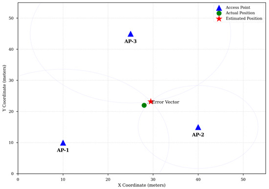
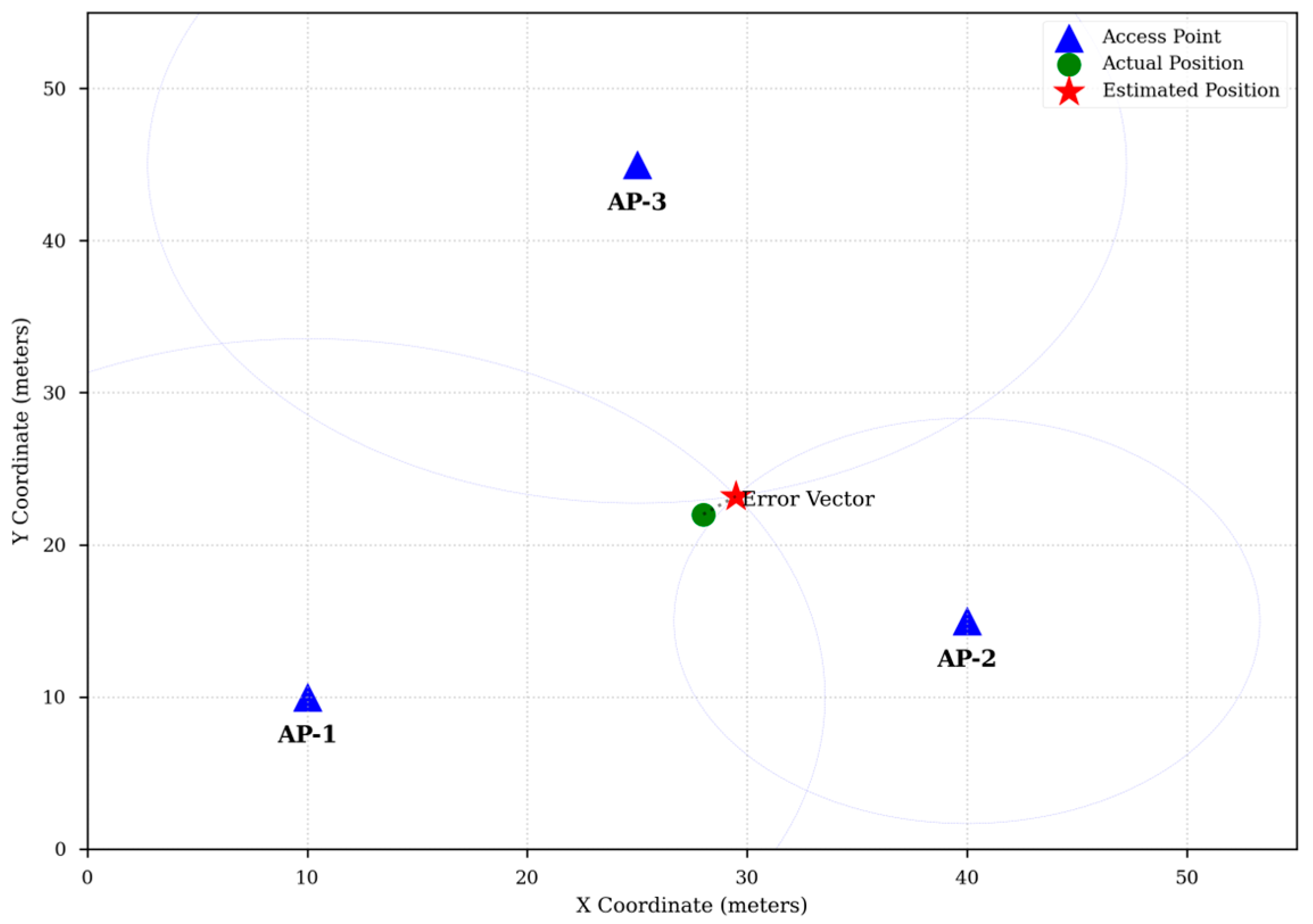
Processing layer: The processing service performs filtering, distance estimation, and multilateration. Temporal smoothing is applied to reduce sudden RSSI fluctuations, an important step because RSSI variance and multipath effects are well-documented error sources in indoor localization [10]. The same layer maps estimated coordinates to semantic campus zones such as reading rooms, corridors, or cafeteria segments (Figure 1).
Figure 1.
RSSI-based multilateration visualization.
Presentation layer: Aggregated occupancy counts are published through a RESTful API and visualized on a dashboard. The API returns zone-level summaries, time-windowed density metrics, and heatmap-ready outputs instead of raw device traces. The service model is consistent with an X-API-Key protected interface in which public consumers access only aggregate occupancy views.
Example localization output produced by the trilateration stage. Estimated client positions are inferred from multiple access-point RSSI observations over a floor-plan coordinate system.
4. Methodology
4.1. RSSI-Based Distance Estimation
The system uses the log-distance path loss model to estimate the distance between a client device and an access point, following standard RSSI ranging practice in Wi-Fi localization. Let denote the estimated distance, the reference distance, the mean received power measured at , and the path-loss exponent. The model is given by
Solving for yields
In indoor campus spaces, the parameter changes with wall density, corridor geometry, furniture, and human mobility. For this reason, the system assumes environment-specific calibration rather than a fixed global value. In practical deployments, calibration can be obtained by collecting RSSI samples at known reference points and fitting through least-squares regression, as recommended in empirical RSSI localization studies.
4.2. Weighted Multilateration
Suppose that a client is observed by access points with coordinates and estimated ranges . The target user position is computed by minimizing the weighted residual error, a formulation commonly used in multilateration-based positioning:
where is the confidence weight assigned to the th range estimate. Stronger and more stable RSSI observations are assigned larger weights, while weaker measurements contribute less to the optimization. This approach reduces the effect of outlier access points and improves robustness in cluttered indoor settings.
The solver requires at least three access points for two-dimensional estimation. When more than three observations are available, the problem becomes overdetermined and the least-squares solution naturally fuses redundant information. If fewer than three reliable observations exist, the pipeline falls back to a proximity estimate based on the strongest access point. Such fallback behavior is practical in sparse-observation cases where full trilateration is unstable.
4.3. Occupancy Aggregation
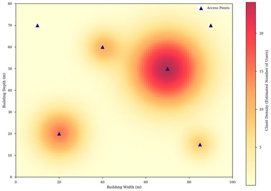
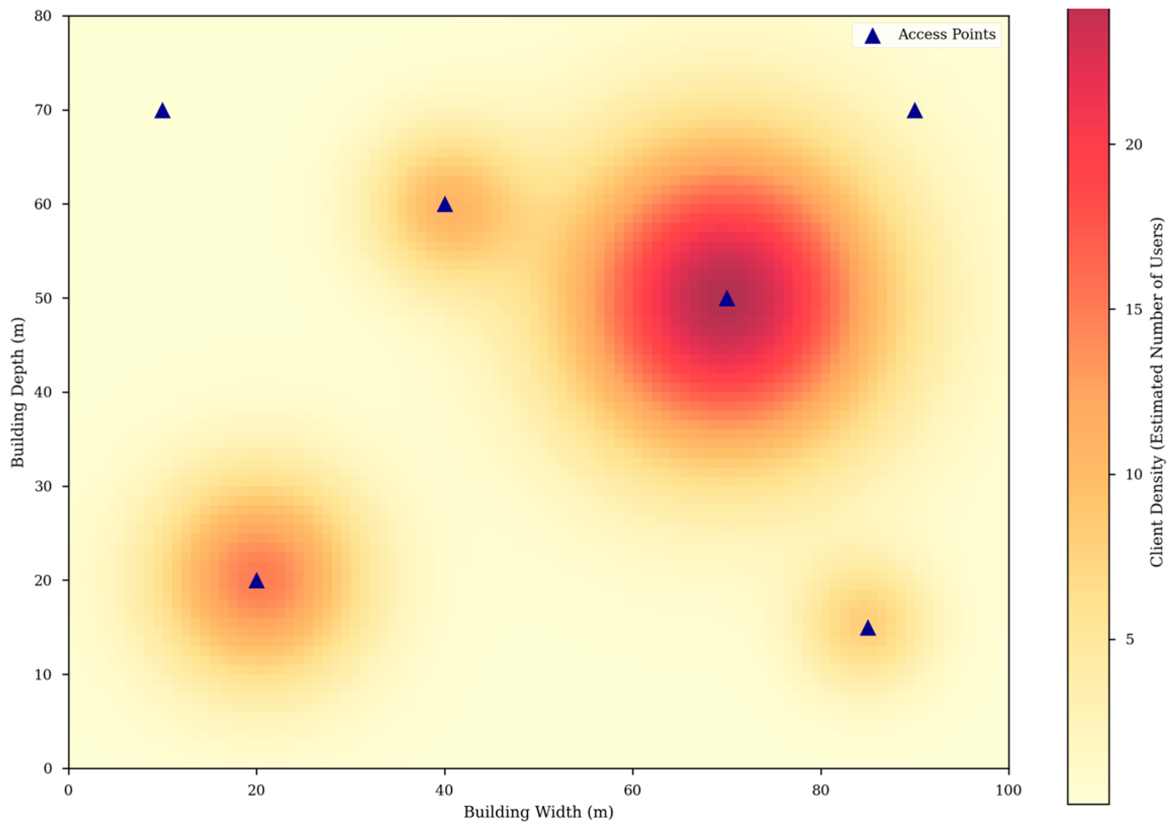
Point estimates are not directly exposed to end users. Instead, each position is mapped to a predefined campus zone using polygon or rectangular region boundaries. Occupancy values are then aggregated over configurable time windows. This produces temporally stable signals suitable for density heatmaps, anomaly detection, and building control integration, which is aligned with occupancy-driven building analytics practice (Figure 2).
Figure 2.
Real-time campus occupancy heatmap.
Sample occupancy heatmap derived from localized Wi-Fi observations. Higher density regions indicate areas where lighting and HVAC policies can be adapted dynamically.
4.4. Privacy and Compliance Considerations
Because wireless infrastructure inherently observes device-level identifiers, privacy must be treated as a primary system requirement rather than a post-processing concern. The proposed framework adopts a privacy-by-design model aligned with KVKK and GDPR principles.
First, raw identifiers are not published through external interfaces. If device-level processing is required internally for deduplication, pseudonymization or one-way hashing can be applied before storage. Second, the retention period of raw observations is minimized; only short-lived technical buffers are maintained for smoothing and localization. Third, application consumers receive aggregated zone statistics instead of individual trajectories. Finally, dashboards emphasize density, occupancy trends, and alert conditions rather than person-level movement. These measures directly support data minimization, purpose limitation, and storage limitation principles emphasized in privacy regulation.
This design is especially relevant for universities, where user populations include students, faculty, staff, and visitors with different expectations regarding consent, transparency, and institutional governance.
5. Experimental Results and Discussion
5.1. Experimental Setup
The evaluation considers a representative indoor floor plan of approximately 50 m × 50 m. A total of 500 randomized client positions are generated across the floor. For each client, synthetic RSSI observations are converted into distance estimates and processed by the weighted multilateration engine. To study scalability, the number of visible access points is varied between 3 and 8. The resulting simulations are then analyzed in terms of localization error distribution, cumulative reliability, and the influence of access-point density on accuracy. This evaluation style is suitable for examining coarse localization behavior before large-scale campus deployment, which is a common progression in indoor positioning studies.Although this setup does not replace a full-scale longitudinal campus deployment, it provides a useful approximation for analyzing localization error trends, floor-level heatmap behavior, and system suitability for occupancy-oriented use cases.
5.2. Localization Accuracy
Table 2 summarizes the positioning performance.
Table 2.
Summary of localization performance.
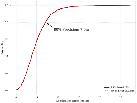
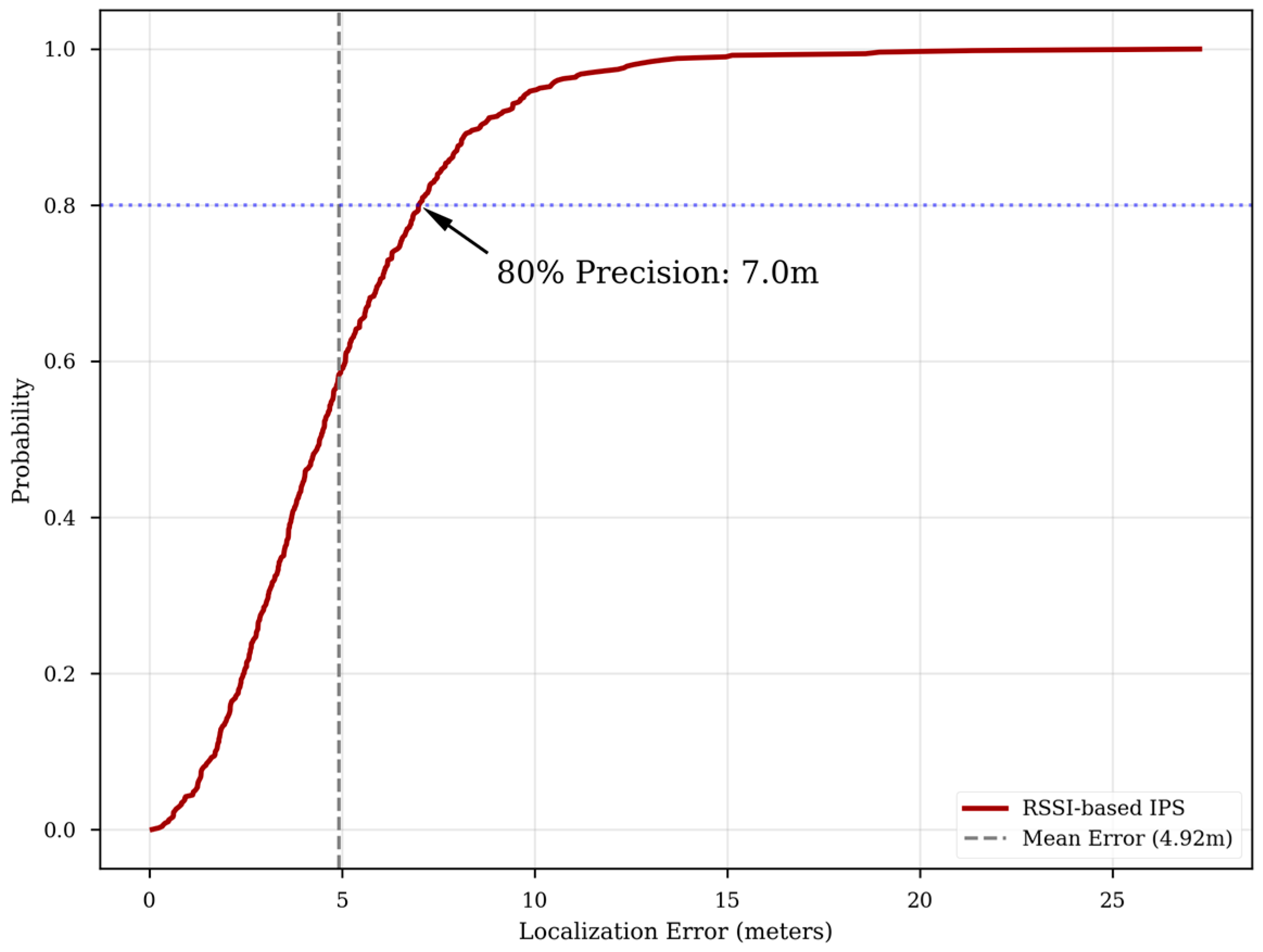
The observed accuracy is sufficient for occupancy analytics, crowd-level monitoring, and space utilization studies, even if it is not adequate for fine-grained navigation. In the simulation campaign, the mean absolute error is 4.88 m, and approximately 80% of localization requests remain below 6.86 m of error. In smart campus scenarios, the difference between adjacent seats is usually less important than correctly identifying whether a room, corridor segment, or service area is crowded.
The cumulative distribution in Figure 3 clarifies the reliability of the localization engine beyond mean error alone. The simulation results show that approximately 80% of localization requests are completed with an error of less than 6.86 m. For occupancy monitoring tasks, the key requirement is not perfect coordinate precision but stable room- or zone-level assignment for the majority of users. The presented CDF therefore strengthens the claim that the system is appropriate for density tracking and operational campus analytics.
Figure 3.
Cumulative distribution function (CDF) of localization error.
Cumulative distribution of localization error: Approximately 80% of the evaluated users are localized within 6.86 m, indicating suitable reliability for occupancy-oriented monitoring.
5.3. Scalability with AP Density
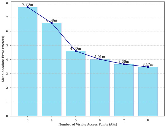
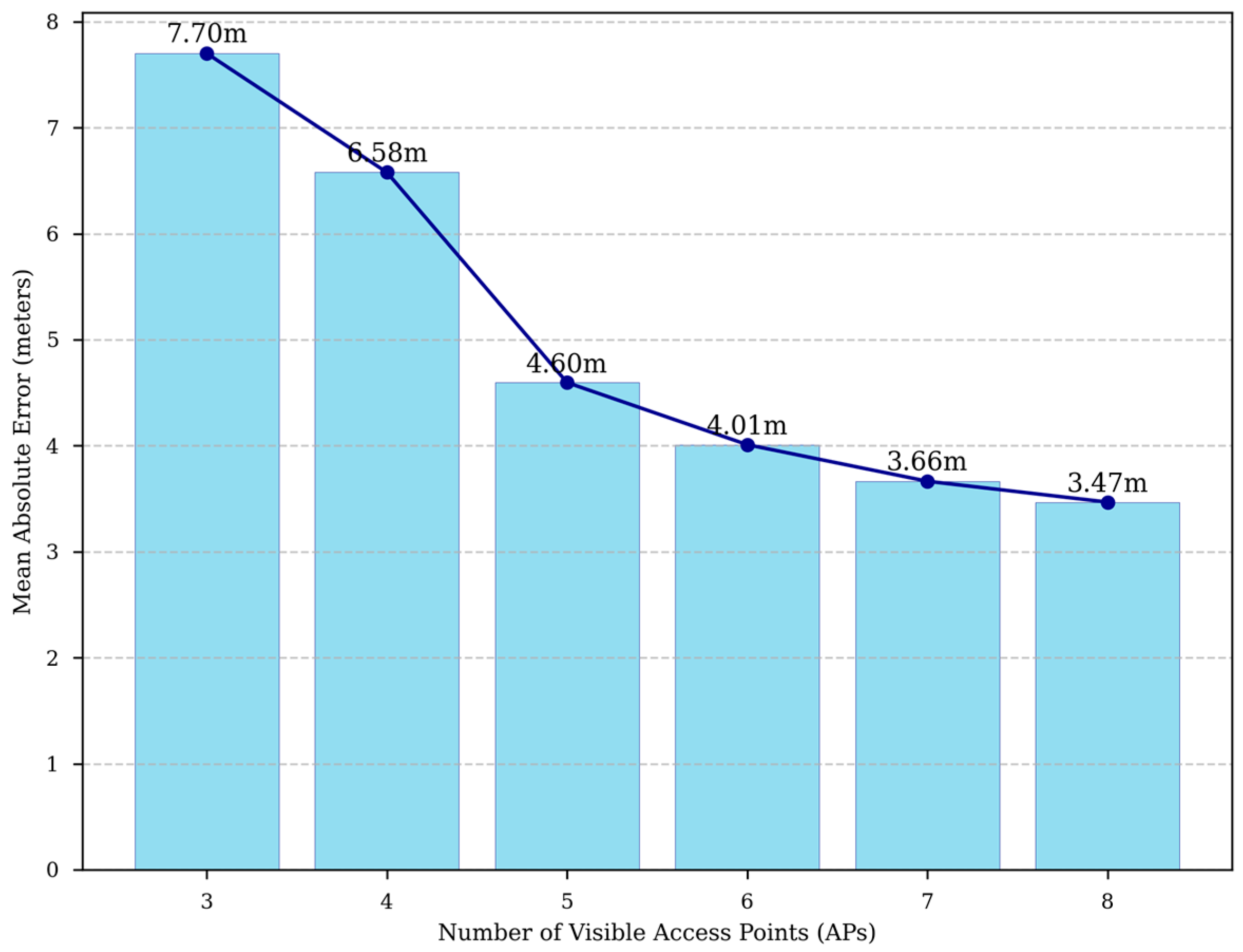
A second analysis examines the relationship between access-point density and localization accuracy. As more access points become visible to the localization engine, the multilateration problem becomes better constrained and the mean absolute error decreases. In particular, increasing the number of visible APs from 3 to 8 leads to a marked improvement in positioning quality, confirming the scalability advantage of reusing dense campus Wi-Fi deployments.
As shown in Figure 4, higher AP visibility improves the geometric constraints of the estimator and reduces mean localization error.
Figure 4.
Impact of AP density on localization accuracy.
Figure 4 shows that AP visibility has a direct impact on estimation quality. This result is particularly important for campus-scale deployments because it suggests that existing Wi-Fi infrastructure can be evaluated not only by coverage for connectivity, but also by observation geometry for occupancy analytics. This analysis confirms that the system can be scaled by utilizing more existing infrastructure to achieve higher precision without additional hardware costs.
Figure 1 illustrates a representative localization output, while Figure 2 shows how point estimates can be transformed into operational density information. Together with Figure 3 and Figure 4, these results provide complementary evidence for spatial accuracy, reliability, scalability, and practical operational value.
5.4. Energy Management Implications
Occupancy-aware control strategies can use the proposed output to modulate lighting and HVAC behavior. For example, a building automation system may reduce airflow in underutilized zones, delay cooling in empty classrooms, or prioritize ventilation in highly occupied study areas. The real-time occupancy data are transformed into heatmaps that act as control signals for smart lighting and HVAC systems. By integrating this information into building management systems, occupancy-driven HVAC and lighting strategies reported for institutional buildings can be supported, with prior studies associating such control with substantial energy savings [9].
5.5. Limitations
The main limitations of the approach stem from RSSI instability, multipath propagation, device heterogeneity, and non-line-of-sight conditions. Human movement and transient obstructions can also distort signal levels. These limitations are consistent with the broader indoor localization literature. Therefore, the proposed method should be interpreted as a cost-effective occupancy sensing framework with coarse localization capability rather than a precision navigation system.
6. Conclusions
This paper presented a scalable framework for campus occupancy analysis and indoor localization that builds on an existing Wi-Fi infrastructure rather than requiring dedicated positioning hardware. By combining controller-level RSSI collection, calibrated path-loss ranging, weighted multilateration, and privacy-conscious aggregation, the system produces occupancy information that can realistically support smart campus operations.
There are several natural directions for future work. First, hybrid localization strategies that incorporate fingerprinting in high-traffic areas may improve accuracy where finer spatial resolution is needed. Second, adaptive calibration methods could estimate path-loss parameters automatically for each building or time period instead of relying on a more static configuration. Third, tighter integration with building automation protocols may enable closed-loop control of HVAC, lighting, and room reservation systems based on live occupancy conditions. Additionally, exploring integration with emerging 5G/6G indoor small-cell networks could further enhance the precision and real-time responsiveness of the localization system without compromising privacy.
Author Contributions
Conceptualization, K.K., S.K. and D.A.; methodology, K.K. and S.K.; software, K.K.; validation, S.K. and D.A.; formal analysis, K.K.; investigation, K.K.; resources, S.K. and D.A.; data curation, K.K.; writing—original draft preparation, K.K.; writing—review and editing, S.K. and D.A. All authors have read and agreed to the published version of the manuscript.
Funding
This research received no external funding.
Institutional Review Board Statement
Not applicable.
Informed Consent Statement
Not applicable.
Data Availability Statement
The original contributions presented in this study are included in the article. Further inquiries can be directed to the corresponding author.
Conflicts of Interest
The authors declare no conflicts of interest.
References
- Bahl, P.; Padmanabhan, V.N. RADAR: An in-building RF-based user location and tracking system. Proceedings IEEE INFOCOM 2000. In Proceeding of the Conference on Computer Communications. Nineteenth Annual Joint Conference of the IEEE Computer and Communications Societies (Cat. No.00CH37064), Tel Aviv, Israel, 26–30 March 2000; Volume 2, pp. 775–784. [Google Scholar] [CrossRef] [Scilit]
- Liu, H.; Darabi, H.; Banerjee, P.; Liu, J. Survey of Wireless Indoor Positioning Techniques and Systems. IEEE Trans. Syst. Man. Cybern. Part C (Appl. Rev.) 2007, 37, 1067–1080. [Google Scholar] [CrossRef] [Scilit]
- Yang, C.; Shao, H.-r. WiFi-based indoor positioning. IEEE Commun. Mag. 2015, 53, 150–157. [Google Scholar] [CrossRef] [Scilit]
- Ilci, V.; Gulal, V.E.; Alkan, R.M.; Cizmeci, H. Trilateration Technique for WiFi-Based Indoor Localization. In Proceedings of the 11th International Conference on Wireless and Mobile Communications (ICWMC 2015), St. Julian’s, Malta, 11–16 October 2015; pp. 23–28. [Google Scholar]
- Zafari, F.; Gkelias, A.; Leung, K.K. A Survey of Indoor Localization Systems and Technologies. IEEE Commun. Surv. Tutor. 2019, 21, 2568–2599. [Google Scholar] [CrossRef] [Scilit]
- Koyuncu, H.; Yang, S.H. A Survey of Indoor Positioning and Object Locating Systems. IJCSNS Int. J. Comput. Sci. Netw. Secur. 2010, 10, 121–128. [Google Scholar]
- Aziz, T.; Koo, I. A Comprehensive Review of Indoor Localization Techniques and Applications in Various Sectors. Appl. Sci. 2025, 15, 1544. [Google Scholar] [CrossRef] [Scilit]
- Teixeira, T.; Dublon, G.; Savvides, A. A Survey of Human-Sensing: Methods for Detecting Presence, Count, Location, Track, and Identity; Yale University: New Haven, CT, USA, 2010; Available online: https://thiagot.com/papers/teixeira_techrep10_survey_of_human_sensing.pdf (accessed on 25 August 2026).
- Yang, J.; Santamouris, M.; Lee, S.K. Review of occupancy sensing systems and occupancy modeling methodologies for the application in institutional buildings. Energy Build. 2016, 121, 344–349. [Google Scholar] [CrossRef] [Scilit]
- Silva-da-Nóbrega, P.I.; Chim-Miki, A.F.; Castillo-Palacio, M. A Smart Campus Framework: Challenges and Opportunities for Education Based on the Sustainable Development Goals. Sustainability 2022, 14, 9640. [Google Scholar] [CrossRef] [Scilit]
- European Union. Regulation (EU) 2016/679 of the European Parliament and of the Council of 27 April 2016 on the protection of natural persons with regard to the processing of personal data and on the free movement of such data (General Data Protection Regulation). Off. J. Eur. Union 2016, L 119, 1–88. [Google Scholar]
- Republic of Turkey. Law on the Protection of Personal Data No. 6698. Official Gazette, 7 April 2016. Available online: https://www.kvkk.gov.tr/Icerik/6649/Personal-Data-Protection-Law (accessed on 25 August 2026).

Disclaimer/Publisher’s Note: The statements, opinions and data contained in all publications are solely those of the individual author(s) and contributor(s) and not of MDPI and/or the editor(s). MDPI and/or the editor(s) disclaim responsibility for any injury to people or property resulting from any ideas, methods, instructions or products referred to in the content. |
© 2026 by the authors. Licensee MDPI, Basel, Switzerland. This article is an open access article distributed under the terms and conditions of the Creative Commons Attribution (CC BY) license.