


Abstract
Wildfire disasters are increasing in scale and severity, underscoring the need for more capable and coordinated aerial firefighting systems. This work presents a performance-based integrated aerial system framework that links the aircraft design tool RISPECT+ with the wildfire mission analysis tool SoSID Toolkit+ to evaluate and optimize system-level effectiveness. Incorporating terrain-specific wildfire characteristics, the framework identifies optimal aircraft configurations and deployment strategies that maximize integrated measurement of effectiveness across diverse regions. A unified surveillance platform strengthens the system of systems architecture and supports the operation of aerial firefighting aircraft. Results show enhanced system-oriented design and multi-agent coordination, with future work focused on optimal designs across diverse aircraft configurations and integrating operational environmental factors relevant to aerial firefighting.
1. Introduction
Wildfire damages have risen across Europe, North America, and Asia as global warming intensifies and extreme weather becomes more frequent, with losses already up 100–200 percent from past decades and projected to grow another 100–160 percent by 2050 [1,2]. The 2025 wildfire incidents in Palisades, LA, United States, and Uiseong–Andong in South Korea exposed the operational limitations of current response systems under strong winds and complex terrain, underscoring the requirement for improved aerial firefighting capabilities across different environmental conditions [3,4,5,6]. Although aerial assets are essential for early detection and rapid suppression, their performance is largely dictated by configuration, operations, terrain, and weather [7,8,9]. In addition, recent advancements in next-generation wildfire suppression technologies further highlight the importance of their effective deployment [10,11,12,13]. Prior System of Systems and wildfire spread modeling studies have not sufficiently integrated aircraft design, terrain-specific operations, and quantitative mission effectiveness across varied wildfire scenarios [14]. This study presents an integrated framework that optimizes aircraft design and operational strategies for SoS-based wildfire surveillance and suppression. The analysis evaluated optimal suppression efficiency reflecting terrain-specific characteristics to identify suitable aircraft configurations. A Measurement of Effectiveness integrating damage reduction with acquisition and operational costs enabled quantitative comparison, showing that terrain-adapted platform architectures and mission strategies demonstrate high operational effectiveness. This work was part of a six-month international student competition, the COLOSSUS Project’s X-Challenge. As part of the X-Challenge, teams were tasked with developing innovative aircraft designs and expanding the COLOSSUS framework with new SoS insights and features. Therefore, the method, analysis and use cases presented in this work are derived from those provided by the X-Challenge’s objectives, constraints and tools. Detailing on the three scenarios referred to in this analysis (Salamis, Greece; Pyrenees, France; and Pacific Palisades, United States) and further information on the challenge can be found in the X-Challenge paper [15].
2. Methodology
2.1. SoSID Toolkit+
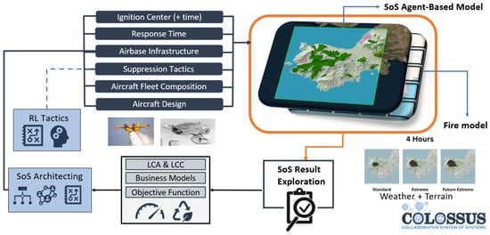
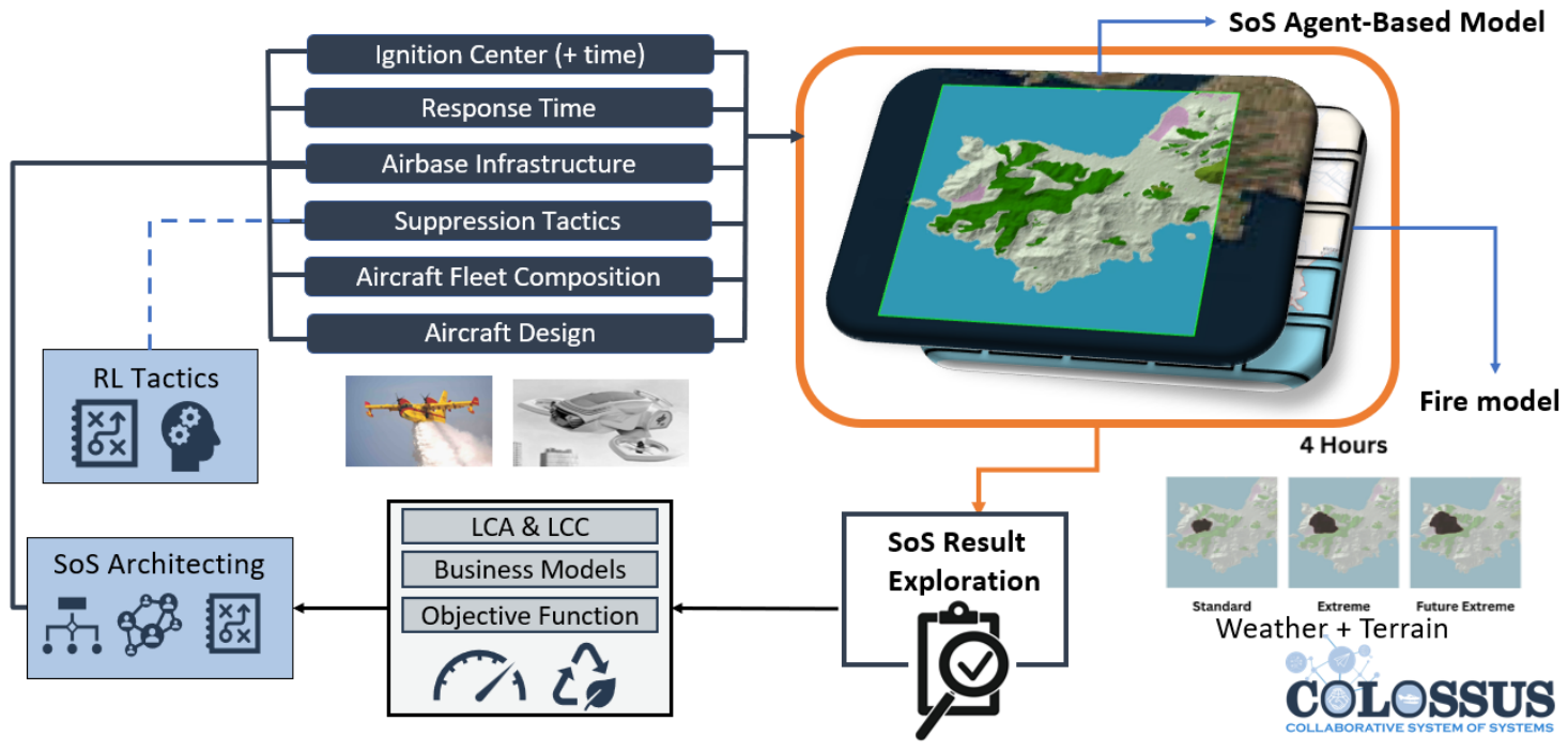
Wildfire suppression missions were conducted using SoSID Toolkit+ (X-Challenge toolkit, German Aerospace Center (DLR), Institute of System Architectures in Aeronautics, Hamburg, Germany), a simulation model applied across three geomorphologically distinct terrains [15]. Due to the inherent performance requirements of wildfire suppression missions, the objective was to identify an optimal strategy that maximized efficiency across the operational environment, thereby preventing the derived solution from being skewed by data from a single terrain type. The wildfire scenarios encompass three regions selected within the X-Challenge framework, as illustrated in Figure 1. Salamis represents an island environment in Greece, where ignition occurs deep within a forest and far from water sources, posing risks to nearby residential areas. The Pyrenees represent steep mountainous terrain with strong winds that accelerate fire spread, making early suppression essential. Palisades reflects an urban-adjacent ignition point in Los Angeles, where even limited fire growth can rapidly threaten dense residential and commercial areas.
Figure 1.
A general framework showcasing the COLOSSUS Project’s SoSID Toolkit+.
2.2. Framework for the Optimal Design of Wildfire Suppression Aircraft
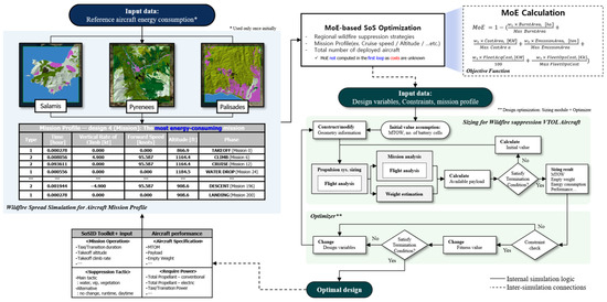
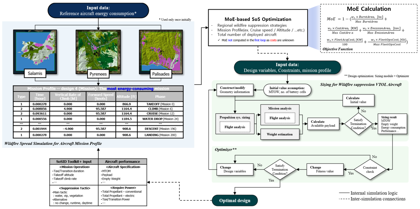
To achieve the optimal design of a wildfire suppression aircraft, this study develops an integrated design framework that links wildfire mission definition with aircraft conceptual design. Wildfire suppression mission profiles are derived from the wildfire spread simulations presented in Section 2.1 using the SoSID Toolkit+ and are used as input conditions for aircraft design. This approach enables the evaluation of suppression effectiveness across multiple fire-prone terrains and mission scenarios, reducing bias toward specific operating conditions and allowing systematic assessment of key design trade-offs. Based on the defined mission profiles, the aircraft is designed using RISPECT+ (in-house version used in this study, Aerospace Vehicle Design Laboratory, Seoul National University, Seoul, Republic of Korea), a conceptual design tool supporting advanced electric propulsion architectures [16]. As shown in Figure 2, the framework forms an optimization loop in which mission requirements drive the aircraft design, and aircraft performance is evaluated using a Measurement of Effectiveness (MoE) as the objective function, representing suppression performance across designated fire-prone terrains. The MoE then guides the optimization of aircraft design variables, while acquisition and operating costs are concurrently considered to achieve a balanced, mission-tailored aircraft design [17].
Figure 2.
Schematic workflow of the proposed wildfire aircraft design framework.
3. Implementation
3.1. Design of Wildfire Suppression Aircraft
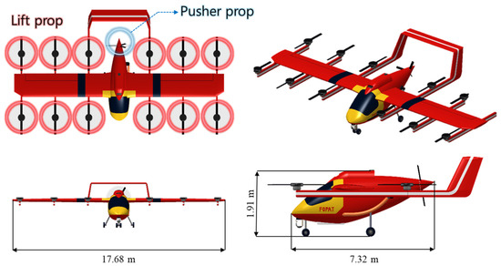
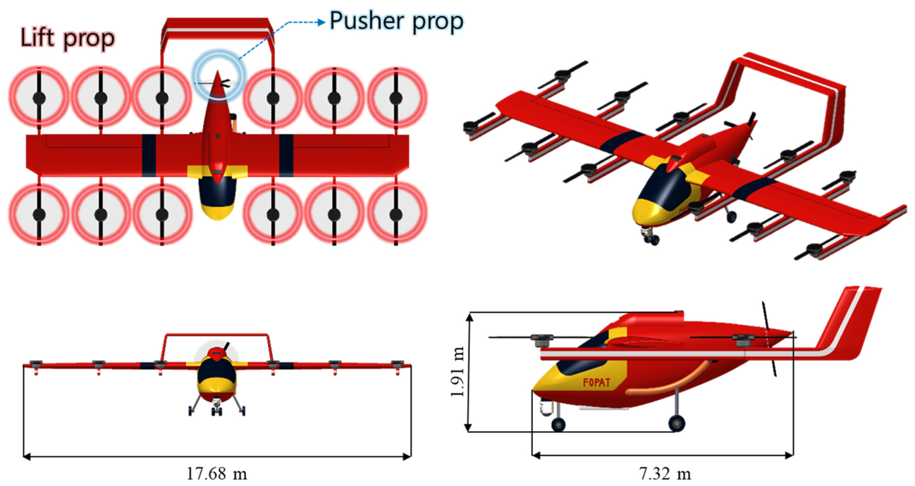
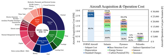
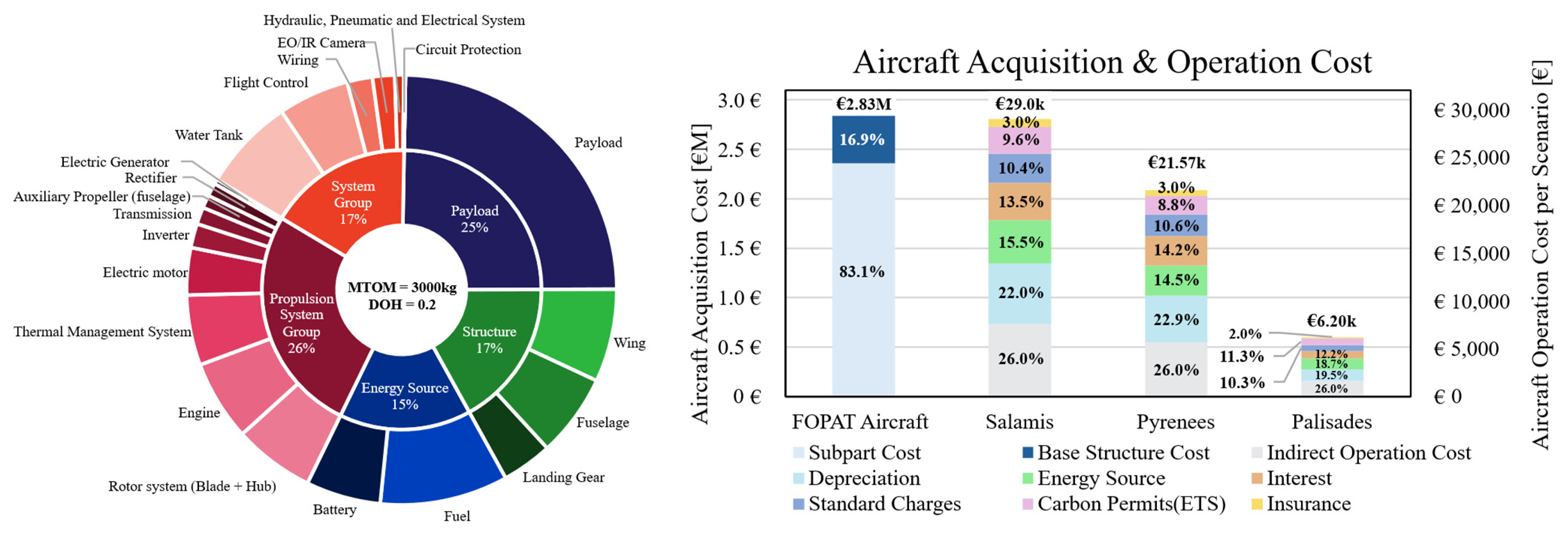
The designed aircraft is a Lift + Cruise with a maximum takeoff mass (MTOM) of 3,000 kg and a degree of hybridization (DOH) of 0.2. As illustrated in Figure 3, the aircraft features a high-wing configuration and is equipped with twelve lift rotors and a single pusher rotor. According to the mass breakdown shown in Figure 4, the key onboard components include a water tank and hose for wildfire suppression and an EO/IR camera for fire detection, along with an internal combustion engine and batteries that constitute the hybrid-electric propulsion system. As shown in Figure 4, the purchase cost per aircraft is estimated at €2.83 M using the DAPCA-IV model, and the operating cost per aircraft ranges from €6 k to €29 k depending on the scenario. The purchase cost is dominated by the total production quantity [18]. The Salamis scenario requires the largest fleet of 22 aircraft, and the total production quantity is set to 30 units to satisfy all scenarios considering maintenance and a 73% operational availability [18].
Figure 3.
Optimized wildfire suppression aircraft configuration.
Figure 4.
Wildfire suppression aircraft mass breakdown, acquisition cost, and scenario-based operational costs.
3.2. Design of Surveillance Operation Equipment
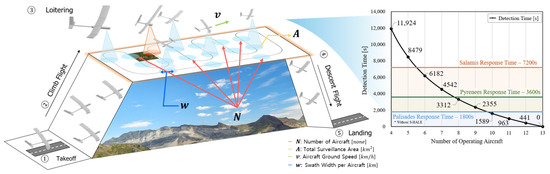
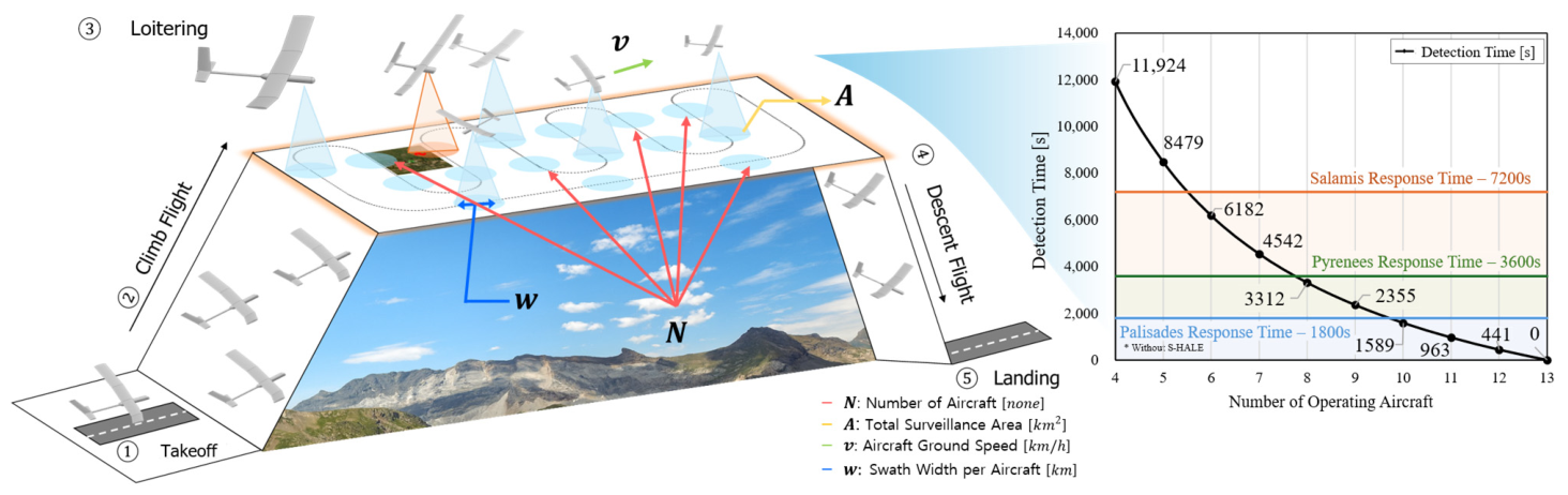
Based on the heterogeneous terrain characteristics, initial equipment deployment times were set at 2 h, 1 h, and 30 min. To shorten this latency, a System of Systems (SoS) analysis was conducted that jointly considered suppression performance and surveillance operational costs. This framework detailed in Figure 5 incorporates the agent operational expenditure data from Table 1 and reflects the reduction in deployment time enabled by enhanced aircraft performance in the target area.
Figure 5.
Long-endurance aircraft for wildfire detection time.
Table 1.
Surveillance operating cost by aircraft quantity.
The operational role of surveillance aircraft was further examined to understand how variations in fleet size influence wildfire detection time and the resulting operational cost [19,20]. Surveillance aircraft continuously monitor the designated target area, and detection time varies with both the number of aircraft deployed and their performance characteristics, including endurance, sensor quality, and coverage rate [18,21]. Increasing the number of surveillance aircraft reduces detection time by expanding coverage and shortening revisit intervals, but it also proportionally increases operational costs due to higher fuel, maintenance, and mission support demands. This trade-off highlights the need to jointly consider detection performance and operating cost when evaluating overall system effectiveness.
3.3. System of Systems Feature Developments
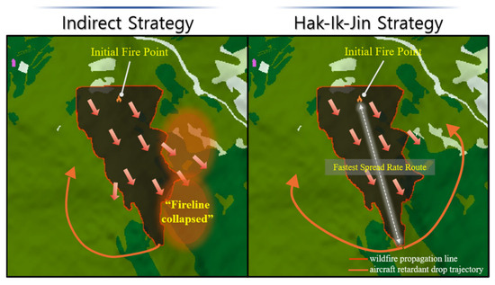
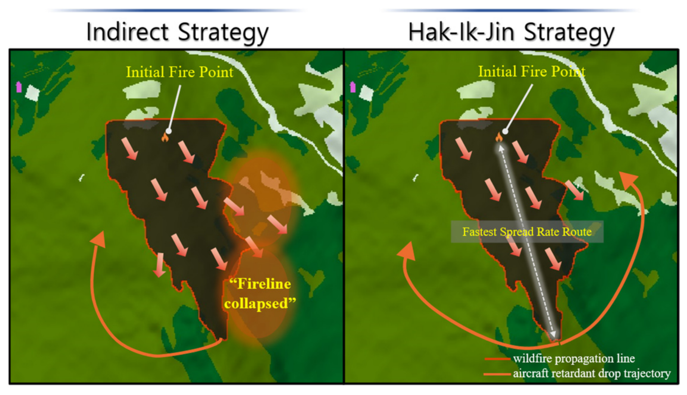
The existing indirect suppression method implemented in SoSID Toolkit+, which relies on a purely unidirectional firefighting approach, exhibits inherent limitations when applied to regions characterized by rapid wildfire spread. This vulnerability becomes particularly evident in the Pyrenees terrain, where steep mountainous topography and strong wind conditions significantly accelerate fire propagation and often overwhelm conventional suppression efforts [22]. Recognizing that such environments demand a more resilient and adaptive strategy, a new concept termed the “Hak-Ik-Jin” strategy was developed to enable bidirectional suppression. As shown in Figure 6, the Hak-Ik-Jin strategy employs bidirectional indirect suppression, constructing firelines from opposing directions along the fastest spread axis to limit flank expansion and enhance containment. These improvements enable scenario-appropriate strategic decision-making based on topography-dependent suppression efficiency. In addition to the Hak-Ik-Jin strategy, the framework employs a Water strategy that preferentially suppresses fires near water sources to delay early spread, as well as VIP strategies that prioritize suppressing fires in urban-adjacent areas to minimize human and property losses. This enables the derivation of optimal terrain-specific suppression strategies within the System of Systems framework.
Figure 6.
Development of a tactical wildfire-suppression mission operation.
4. Application
The integrated design framework loop was used to derive region-specific fleet configurations maximizing MoE, and Table 2 compares suppression-only and long-endurance scenarios under identical tactics and fleet sizes. In suppression-only operations, Salamis achieved its MoE of 0.709 by deploying 20 aircraft using the Water strategy, as its wide forested area allows early suppression near water sources to effectively limit fire spread. The Pyrenees recorded an MoE of 0.723 when the Hak-Ik-Jin (Crane) strategy introduced in Section 3.3 was applied with 12 aircraft, since the steep and complex Alpine terrain favors indirect, encircling suppression that constrains fire expansion. The Palisades region achieved an MoE of 0.741 with only 5 aircraft under the VIP strategy, because its proximity to urban areas makes prioritizing suppression near populated zones more effective in reducing damage and costs. The addition of long-endurance aircraft improved performance in regions with long initial deployment times, reducing burned areas from 123.87 to 3.12 ha in Salamis and from 135.02 to 3.13 ha in the Pyrenees and increasing MoE to 0.734 and 0.733, respectively, due to earlier on-station arrival during the early fire growth phase. In contrast, the Palisades region exhibited a slight MoE decrease from 0.741 to 0.740, as increased operational costs outweighed the marginal benefit of faster deployment. Table 2 presents the total fleet acquisition and operating costs, assuming a production of 30 suppression and 13 long-endurance aircraft required to achieve an initial detection time of 0 s. Notably, adding surveillance aircraft raised the average MoE from 0.724 to 0.735, confirming the value of enhanced situational awareness.
Table 2.
MoE breakdown based on terrain and tactical strategy.
5. Conclusions
This study developed a comprehensive framework for deriving optimal design and operational strategies for aerial wildfire-suppression assets across heterogeneous terrain environments. As part of the COLOSSUS X-Challenge, the framework integrates conceptual aircraft design with wildfire spread simulation, enabling quantitative evaluation of suppression performance under varying operational environments, deployment times, strategies, and aircraft capabilities. Using this approach, terrain-specific mission strategies were identified, and aircraft configurations that yield the highest suppression effectiveness were designed. Furthermore, the study demonstrated that the operation and utilization strategies of co-deployed aerial surveillance assets play a critical role in overall mission operations. By incorporating these systems at the System of Systems level, the framework accounts for early detection benefits, deployment timing, and operational cost, ultimately yielding more effective solutions in complex wildfire spread scenarios. Regional analyses of surveillance-asset placement revealed advantageous and disadvantageous monitoring locations depending on local wildfire characteristics, offering insights that can guide the development of future wildfire-response agents. Overall, this framework provides a structured methodology for evaluating and optimizing aerial firefighting systems under increasingly severe wildfire conditions. Future work may expand the framework by integrating additional wildfire spread models, exploring diverse propulsion and energy-system architectures, and incorporating real-world operational data to enhance the fidelity and applicability of advanced aerial wildfire-suppression aircraft.
Author Contributions
Conceptualization, G.L., S.P., S.C. and D.L.; methodology, G.L., S.O. and D.L.; software, G.L., S.P., S.O., B.P. and D.L.; validation, G.L. and D.L.; formal analysis, G.L.; investigation, G.L. and D.L.; resources, G.L., B.P., M.K. and D.L.; data curation, G.L. and D.L.; writing—original draft preparation, G.L.; writing—review and editing, G.L., D.L., N.K., N.N. and P.S.P.; visualization, G.L.; supervision, D.L., N.K., N.N. and P.S.P.; project administration, D.L., N.K., N.N. and P.S.P.; funding acquisition, G.L., D.L., N.K., N.N. and P.S.P. All authors have read and agreed to the published version of the manuscript.
Funding
This research was conducted within the framework of the COLOSSUS Project (Collaborative System of Systems Exploration of Aviation Products, Services and Business Models), funded by the European Union Horizon Europe program under grant agreement No. 101097120, and was also supported by the National Research Foundation of Korea (NRF) grant funded by the Korean government (MSIT) (RS-2025-23323704).
Institutional Review Board Statement
Not applicable.
Informed Consent Statement
Not applicable.
Data Availability Statement
The data presented in this study are available on request from the corresponding author. The data are not publicly available due to restrictions associated with in-house developed tools and project-specific data.
Conflicts of Interest
The authors declare no conflicts of interest.
Abbreviations
The following abbreviations are used in this manuscript:
| DOH | Degree of Hybridization |
| EO/IR | Electro-Optical/Infrared |
| HALE | High-Altitude Long-Endurance |
| MoE | Measurement of Effectiveness |
| MTOM | Maximum Takeoff Mass |
| Q | Quantity |
| RISPECT+ | Rotorcraft Initial Sizing and Performance Estimation Code and Toolkit+ |
| SoS | System of Systems |
| SoSID | System of Systems Inverse Design |
References
- IPCC. Climate Change 2021: The Physical Science Basis. Contribution of Working Group I to the Sixth Assessment Report of the In-tergovernmental Panel on Climate Change; Masson-Delmotte, V., Zhai, P., Pirani, A., Connors, S.L., Péan, C., Berger, S., Caud, N., Chen, Y., Goldfarb, L., Gomis, M.I., et al., Eds.; Cambridge University Press: Cambridge, UK; New York, NY, USA, 2021. [Google Scholar] [CrossRef] [Scilit]
- XDI Systems. 2025 European Forest Fire Risk: An Analysis of Damage to Infrastructure from Forest Fire. Available online: https://www.actu-environnement.com/media/pdf/news-46633-rapport-XDI-risques-incendies-UE.pdf (accessed on 16 February 2025).
- Los Angeles City Fire Department (LAFD). Palisades Fire After-Action Review Report (AARR); Los Angeles City Fire Department: Los Angeles, CA, USA, 2025.
- Office for Government Policy Coordination. Wildfire Response Central Disaster and Safety Countermeasures Headquarters 5th Meeting—Opening Remarks. Available online: https://www.opm.go.kr (accessed on 20 February 2025).
- Korea Forest Service. Ground–Air–Space Integrated Technology Used to Analyse Large-Scale Wildfire Perimeters in Five Cities and Counties in Gyeongbuk. Available online: https://www.forest.go.kr (accessed on 20 February 2025).
- Greenpeace Korea. Protected Area Management Status Report; Greenpeace Korea: Seoul, Republic of Korea, 2025; Available online: https://www.greenpeace.org/korea (accessed on 20 February 2025).
- Yıldız, M.; Öztürk, O.; Akbıyık, T. Effectiveness of Helicopters in Fighting Forest Fires in Türkiye: A Data Envelopment Analysis Approach. Fire 2025, 8, 156. [Google Scholar] [CrossRef] [Scilit]
- Wheatley, M.; Wotton, B.M.; Woolford, D.G.; Martell, D.L.; Johnston, J.M. Modelling initial attack success on forest fires suppressed by air attack in the province of Ontario, Canada. Int. J. Wildland Fire 2022, 31, 774–785. [Google Scholar] [CrossRef] [Scilit]
- U.S. Forest Service. Aerial Firefighting Use and Effectiveness (AFUE) Study—Final Summary Report; U.S. Department of Agriculture: Washington, DC, USA, 2020.
- Legendre, D. Fluid Dynamics of Airtanker Firefighting. Annu. Rev. Fluid Mech. 2024, 56, 577–603. [Google Scholar] [CrossRef] [Scilit]
- Boroujeni, S.P.H.; Razi, A.; Khoshdel, S.; Afghah, F.; Coen, J.L.; O’Neill, L.; Fule, P.; Watts, A.; Kokolakis, N.-M.T.; Vamvoudakis, K.G. A Comprehensive Survey of Research Towards AI-Enabled Unmanned Aerial Systems in Pre-, Active-, and Post-Wildfire Management. Inf. Fusion 2024, 108, 102369. [Google Scholar] [CrossRef] [Scilit]
- Chaturvedi, S.; Thakur, P.S.; Khanna, P.; Ojha, A.; Song, Y.; Awange, J.L. Satellite Image-Based Surveillance and Early Wildfire Smoke Detection Using a Multiattention Interlaced Network. IEEE Trans. Ind. Inform. 2025, 21, 3806–3815. [Google Scholar] [CrossRef] [Scilit]
- Ellis, K.; Johnson, M.; Neogi, N.; Homola, J. NASA Research to Expand UAS Operations for Disaster Response; NASA Langley Research Center: Hampton, VA, USA; NASA Ames Research Center: Moffett Field, CA, USA, 2024. Available online: https://ntrs.nasa.gov/citations/20240007804 (accessed on 20 February 2025).
- Prakasha, P.S.; Kilkis, S.; Naeem, N.; Ratei, P.; Nagel, B. System of Systems Simulation Driven Wildfire Fighting Aircraft Design and Fleet Assessment. In Proceedings of the AIAA AVIATION 2021 Forum, Virtual Event, 2–6 August 2021; American Institute of Aeronautics and Astronautics: Reston, VA, USA, 2021. [Google Scholar] [CrossRef] [Scilit]
- Kalliatakis, N.; Naeem, N.; Prakasha, P.S. COLOSSUS X-Challenge Student Competition- Exploring Solutions to Wildfire Fighting Using System-of-Systems Analysis. In Proceedings of the 15th EASN Conference 2025, Madrid, Spain, 14–17 October 2025. [Google Scholar]
- Lee, D.; Lim, D.; Yee, K. Generic Design Methodology for Vertical Takeoff and Landing Aircraft with Hybrid-Electric Propulsion. J. Aircr. 2022, 59, 278–292. [Google Scholar] [CrossRef] [Scilit]
- Kim, H.; Yee, K. A Novel Cost Estimation Method for UAM eVTOLs. J. Korean Soc. Aeronaut. Space Sci. 2021, 49, 233–241. [Google Scholar] [CrossRef] [Scilit]
- Korea Forest Service, Forest Aviation Headquarters. Helicopter Utilization Rate by Aircraft. Public Data Portal. Available online: https://www.data.go.kr/data/15137836/fileData.do (accessed on 20 February 2025).
- Fladeland, M. Development and Maturation of HAPS and Related Technologies for the Future NASA Earth System Observatory. In Proceedings of the IEEE Geoscience and Remote Sensing Society Instruments and Future Technologies Webinar, 3 October 2024; NASA Ames Research Center: Moffett Field, CA, USA, 2024. Available online: https://ntrs.nasa.gov/api/citations/20240013075/downloads/IEEE%20HAPS%20talk%20.pdf (accessed on 15 October 2024).
- Alexander, M.E.; Cruz, M.G. Are the applications of wildland fire behaviour models getting ahead of their evaluation again? Environ. Model. Softw. 2013, 41, 65–71. [Google Scholar] [CrossRef] [Scilit]
- Ruffault, J.; Mouillot, F. How a new fire-suppression policy can abruptly reshape the fire-weather relationship. Ecosphere 2015, 6, 1–19. [Google Scholar] [CrossRef] [Scilit]
- Finney, M.A. The challenge of quantitative risk analysis for wildland fire. For. Ecol. Manag. 2005, 211, 97–108. [Google Scholar] [CrossRef] [Scilit]

Disclaimer/Publisher’s Note: The statements, opinions and data contained in all publications are solely those of the individual author(s) and contributor(s) and not of MDPI and/or the editor(s). MDPI and/or the editor(s) disclaim responsibility for any injury to people or property resulting from any ideas, methods, instructions or products referred to in the content. |
© 2026 by the authors. Licensee MDPI, Basel, Switzerland. This article is an open access article distributed under the terms and conditions of the Creative Commons Attribution (CC BY) license.