


Abstract
The year 2025 saw the continuing trend of worsening wildfire severity and impact with escalating costs, burnt area and casualties. Subsequently, the capability for a rapid response operation is ever-growing, with aerial assets providing a key role in fulfilling this function. One problem with aerial suppression is the reliance on updated fire data and precise fire front information. Drones or other long-endurance vehicles are commonly used to assist in this matter, providing real-time data and imagery to the manned suppression bombers. The interactions and collaboration between these systems to achieve an improved wildfire suppression can be classified as a system-of-systems (SoS). To facilitate the design, interaction and communication of the surveillance drones and suppression aircraft, this paper develops a holistic framework using an agent-based simulation. The framework allows for the analysis of top-level drone design parameters and operational considerations with their communication and collaboration both with each other and the suppressive agents. The results showcase the importance of swath radius for better wildfire coverage and suppression, with radii less than 50 m preventing successful exploration of the fire. The importance of monitoring is highlighted by the observed greater reductions in burnt area and fleet energy usage when increasing the monitoring agent fleet size by 50% compared to the same increase in suppression agent fleet size.
1. Introduction
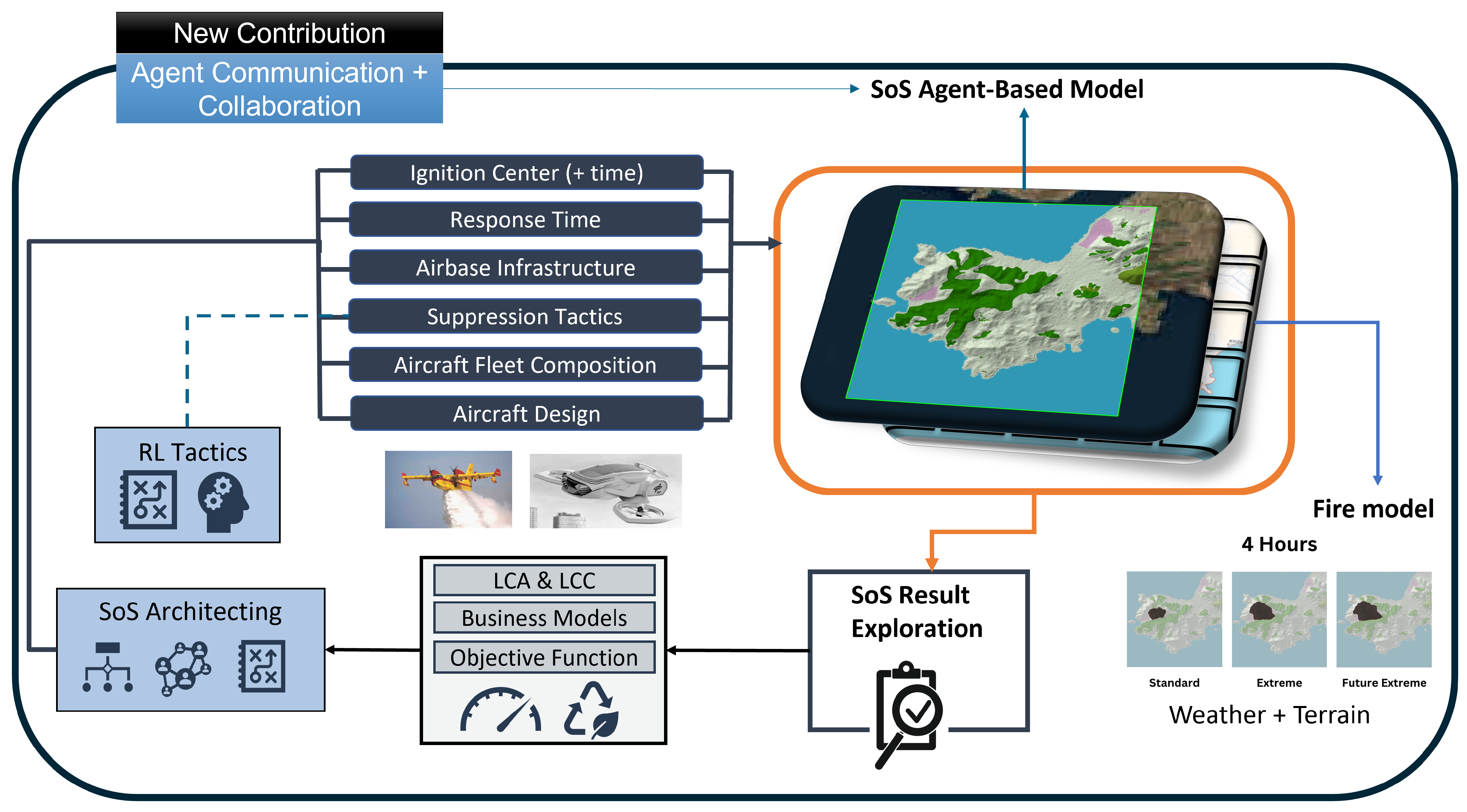
Wildfire fighting is a complex problem relying on timely coordination of multiple assets to suppress and contain the fire. Fires can fall prone to extreme, uncontrolled burning, surmounting in typically record-breaking costs, environmental damage and emissions. One critical reason for this can be due to the limited communication and surveillance of the wildfire front and area [1]. Within the EU COLOSSUS Project (the project overview can be found on https://colossus-sos-project.eu/, accessed on 20 April 2026), the problem of decomposing the wildfire fighting problem into a system-of-systems (SoS) to evaluate heterogeneous aerial fleets and architectures is handled with comprehensive framework utilizing an agent-based modeling (ABM) simulation [2]. The need for simulation and ABM application to SoS is essential for the future development of aircraft systems and architectures [3]. Within this paper, the toolkit, termed SoSID Toolkit [4], is developed with aerial surveillance agents and communication capabilities to enable the modeling of relationship between information gathering and suppressing the wildfire. In doing so, a holistic SoS framework is presented (see Figure 1).
Figure 1.
COLOSSUS SoSID Toolkit framework with new monitoring agent implementation.
The topic of monitoring and surveillance in wildfire fighting, especially with the use of UAVs, has been a research trend within the last decade. The idea of implementing autonomy into the drone network to assist in discovering fire fronts or providing continuous coverage is the largest sector [5], with frameworks using artificial intelligence and different learning methods being researched. The effectiveness of using drone networks to assist in wildfire management [6] and suppression [7] has been evidenced, with different strategies of optimizing the pathing and tracking of the wildfire being done [8]. Recently, decoupling of the suppression and surveillance was attempted, to allow for each operational optimization in the SoS [9], providing more efficient collaboration in small-scale wildfire analysis. Despite these developments, limitations in communication between the surveillance agents and suppressive agents are not explored, especially in regards to larger wildfire operations. To tackle this, ABM offers utility in providing the emergent behaviors that can occur due to communication delays within different communication and surveillance strategies.
2. Methodology
The SoSID Toolkit has already been developed for the wildfire fighting use case, wherein an underlying fire model using cellular automata [10] is overlaid with an agent model which interprets the fire data and conducts suppression, and resupplies and refuels with aircraft agents based on user-inputted operational choices and constraints [11,12]. Typically the tool assumes omniscient knowledge of the fire front, meaning that all fire locations and spread rates are known at all times. For this paper, the simulation has been adapted to remove this ability, relying solely on monitoring agents to provide knowledge to the other agents. To develop the monitoring agents, the same base layer aircraft agent used for the suppressive agents can be used, but new functions relating to the discovery, tracking and communicating of the wildfire front must be modeled.
2.1. Fire Discovery
Each monitoring agent is given an input swath radius, representing their vision capabilities. Any terrain cells within this radius are noted, and their burn rates and extinction phases are also considered for tracking. Each agent stores this information in a personal knowledge map, alongside a timestamp. Non-monitoring agents also have knowledge maps, but rely on the monitoring agents to provide them with this information, through a centralized, shared knowledge base. When the simulation starts, agents are given a preliminary outline of the fire fronts, populating their knowledge base. Knowledge bases are also automatically updated for all agents for fire fronts that are within 200 m of residential areas, modeling Internet of Things (IoT) sensors and alarms [6].
2.2. Fire Tracking
With the fire knowledge bases defined, agents need to be able to interpret their knowledge base and determine how to update their knowledge base given their location and time. This is handled in the simulation through a value function. When agents select a destination to travel to, they consider several variables:
- Distance between fire front(s) and agent. Priority is updating fire fronts that require least effort to travel to.
- Distance between fire front(s) and other monitoring agents. Priority is updating fire fronts that other monitoring agents are not actively tracking.
- Distance between fire front(s) and suppression points. Priority is updating fire fronts that suppression agents are looking to suppress.
- Fire edges. Priority is to fully capture the fire front; edges may indicate incomplete knowledge base.
- Time since last updates at fire front(s). Priority is to update fire fronts that have not been updated for a while.
All of these factors are multiplied with a user-defined weight value, allowing for operational design customization and exploration. Based on the agent’s knowledge base, a fire front will be selected as the best considering the above factors, upon which the agent will then travel to it. Whilst traveling, the agent will monitor any information along the way to its destination. Upon reaching the destination, the agent will then restart the selection process.
2.3. Communication
As each knowledge base is updated, the agents also have methods of sharing their knowledge base, symbolizing communication in wildfire operations. Communication comes in the form of three methods:
- 1.
- Update frequency: All agents share their knowledge bases with one another, updating burning areas and extinguished areas. This represents network updates in the case of autonomy or potentially communication intervals in human-based operations.
- 2.
- Proximity based communication: Monitoring agents share their knowledge base with any agent within a certain radius. This represents communication band limitations or low-fidelity antenna gain constraints.
- 3.
- Arrival at airbase: Upon landing for refuel, agents will upload and receive fire front knowledge, similar to the upload of data to a central storage network.
The summation of the new developments results in a new set of monitoring agent-specific parameters: swath radius (m), communication radius (m) (can be 0 in which agents do not communicate with those nearby), communication frequency (min), response time (min) (monitor agents can have earlier takeoff times compared to typical suppression response times) and selection weights(distance, time since last update, edge cost).
2.4. Scenario Definition
To verify and evaluate the impact of monitoring agents on a wildfire fighting mission, a sample disaster mission from the COLOSSUS Project in the Pyrenees was used as a baseline. In the example, a fire ignites in the early morning at 06:15 in the mountains. Given the terrain conditions and weather, the fire spread rate is extreme, making this scenario difficult. For this analysis, a grid of 10 × 10 km around the fire is used; if the fire cannot be contained within this boundary, the mission is considered a failure. The baseline is set up considering standard EU fleet capabilities with a set of 4 DHC-515 aircraft [12]. The baseline considers omniscient knowledge with a 30 min response time for the water-bombers.
2.5. Assumptions and Limitations
As for any model, the implementation considered in this study has a few limitations and key assumptions that underlie the following analysis. These are outlined below:
- The Cellular Automata fire model works best for larger-scale fires, as typical cell sizes used in prior validations are those of 30 m [10]. Smaller cell size accuracies have not been extensively tested.
- Communication between agents is flawless—there are no data delays in sharing, and data loss is not considered.
- Surveillance equipment tracks and monitors fires accurately and instantaneously—no processing time or errors are considered, and area coverage is constant (no sweeps required).
- Aircraft suppressions are precise and definitive—the number of suppressions to suppress a fire front does not vary on fire/terrain conditions.
- Suppression aircraft (when functioning with monitoring agents) are unable to see the fire and make independent observations.
3. Results
3.1. Baseline and Monitoring Verification
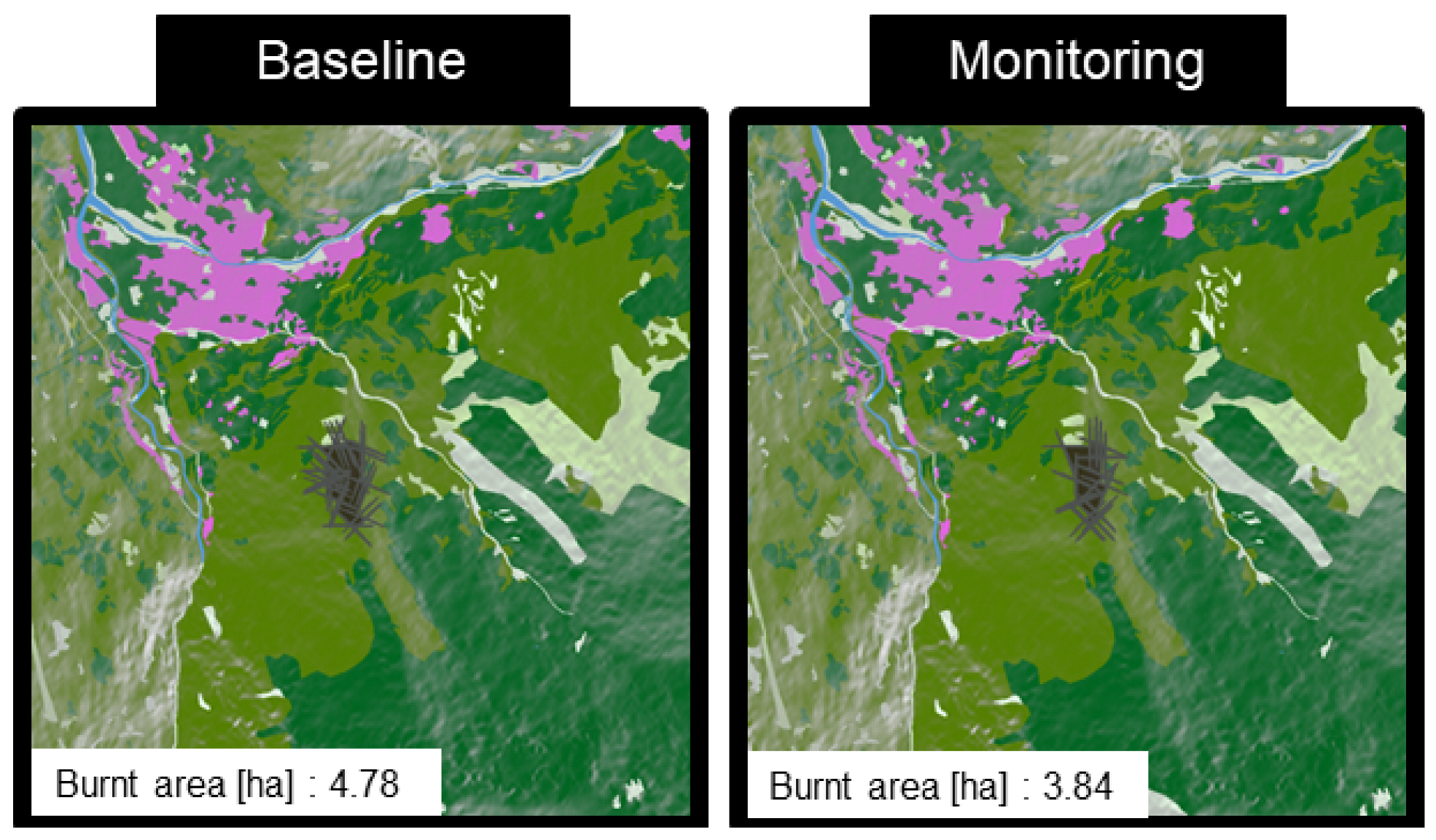
The defined baseline is able to completely extinguish the fire with 4.78 ha of burnt area and a mission time of 59 min. Verification of the monitoring implementation is done by extending this baseline with three monitoring UAVs in perfect conditions. This means that the agents communicate flawlessly and at every time step, ensuring that the knowledge is constantly shared and fire fronts are known as they are found. The swath radius is set to 200 m for this example, matching potential advanced thermal cameras (data reference: https://www.overwatchimaging.com, accessed on 18 October 2026), and they are given a 5 min earlier response time to the fire ignition. In this ideal setup, the fleet is able to extinguish the fire with 3.84 ha burnt area with a mission time of 48 min, beating the baseline. This discrepancy is due to the interactions of the suppressions between the DHC-515. Monitoring communication updates give slight knowledge delays, resulting in delayed suppressions, which can be beneficial to creating a collaborative fireline sometimes. A comparison of the final fire state with suppressions is shown in Figure 2.
Figure 2.
Mission comparison between baseline and monitoring addition.
3.2. Monitoring Agent Design Effects
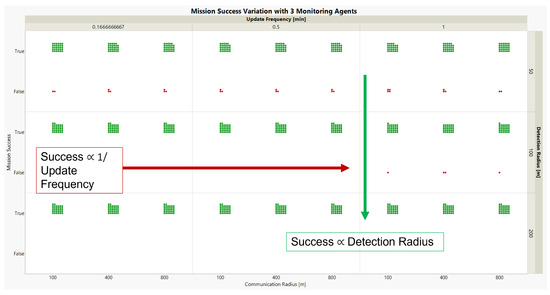
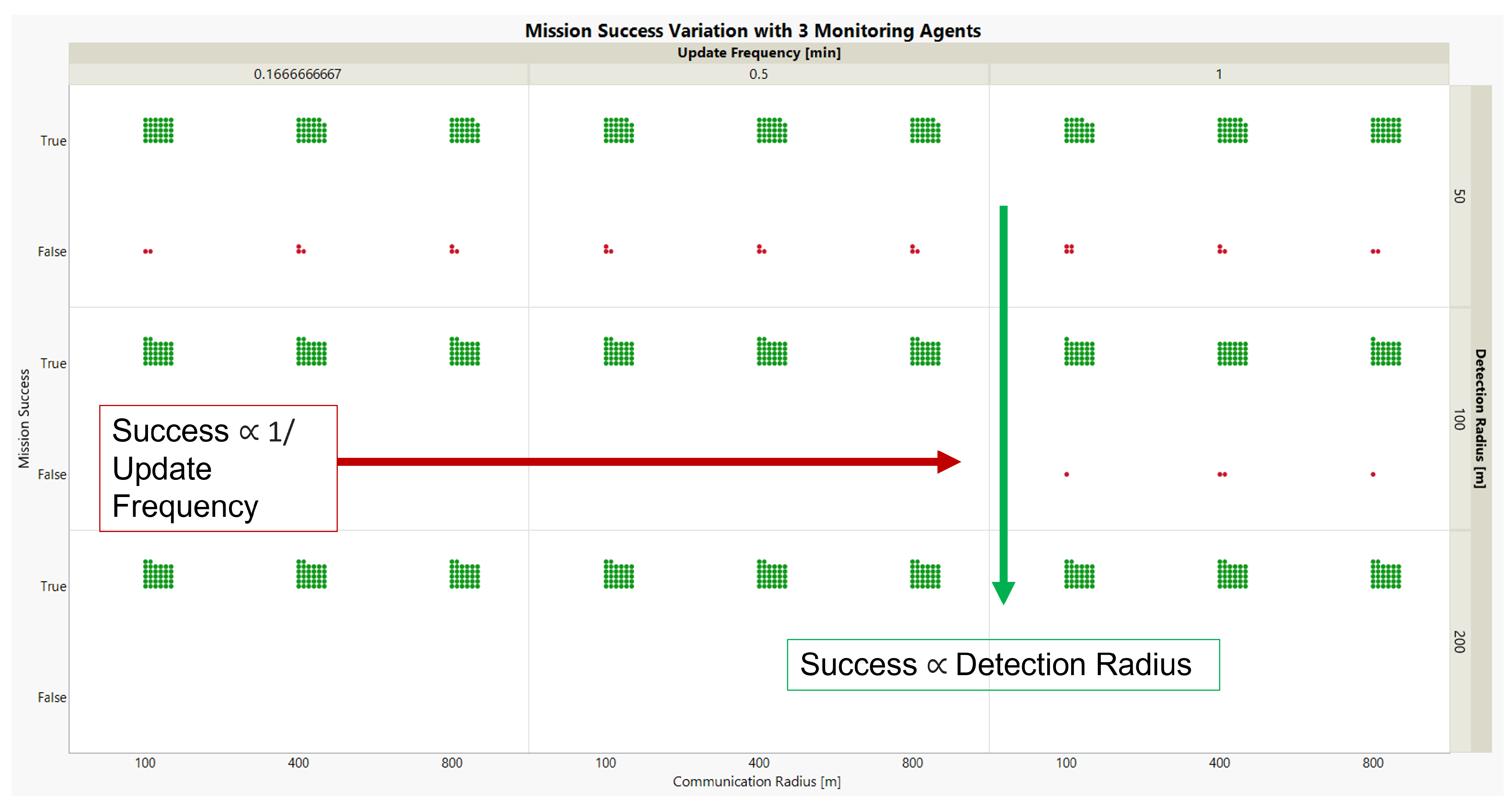
With the functionality being verified, a demonstration of the framework was conducted through a design of experiments (DoE), focused on monitoring agent design traits, like swath radius and communication technology, alongside operational design, such as fleet size and fire tracking strategy. Figure 3 presents the DoE for the monitoring agent, with changes made to the swath/detection radius, communication/update frequency and the proximity communication radius alongside the mission success.
Figure 3.
DoE results for monitoring agent design trait impact on fire containment success (green = success, red = mission failure).
From the results, the impact of swath radius is significantly higher than the other variables, with fewer mission failures as the radius increases. Past 200 m, an emergent behavior is observed whereby the monitoring agents choose to actively loiter in regions of the fire instead of roam around in circles as they obtain full coverage. Conversely, smaller swath radii result in agent trapping, where they are not able to recognize the fire they see in its entirety and get constrained to smaller regions, resulting in more mission failures for the 50 m swath radius. With 100 m, the mission success is almost guaranteed; however, delayed updates, as is the case with an update frequency of 1 min, may permit the fire to rapidly spread, resulting in some mission failures. Communication radius did not seem to have much significance in the mission’s performance, as knowledge sharing was more reliant on the global update than local sharing. This could be different if the update frequency period is much larger than 1 min; however, this was not evaluated in this study.
Based on the above analysis, preliminary conclusions on future monitoring UAV design can already be extrapolated:
- High area coverage with their surveillance equipment is necessary as it allows zoning between UAVs, reducing the need to constantly track and follow fire fronts—investing into a larger payload design to accommodate a better technology is worthwhile.
- In absence of high area coverage equipment, designing the network with frequent communication exchanges is crucial (ensuring stable communication relays and policies) as this can lead to a similar performance to better surveillance technology.
- If fewer UAVs are employed, the importance of frequent communication is more detrimental to an efficient operation than higher swath radii. This effect dwindles as more UAVs are employed, as then a stable network is maintained due to the higher fire coverage. As such, consideration of the fleet size and operations relative to investment on aircraft design level is essential.
3.3. Fleet Composition Considerations
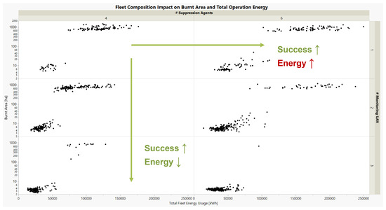
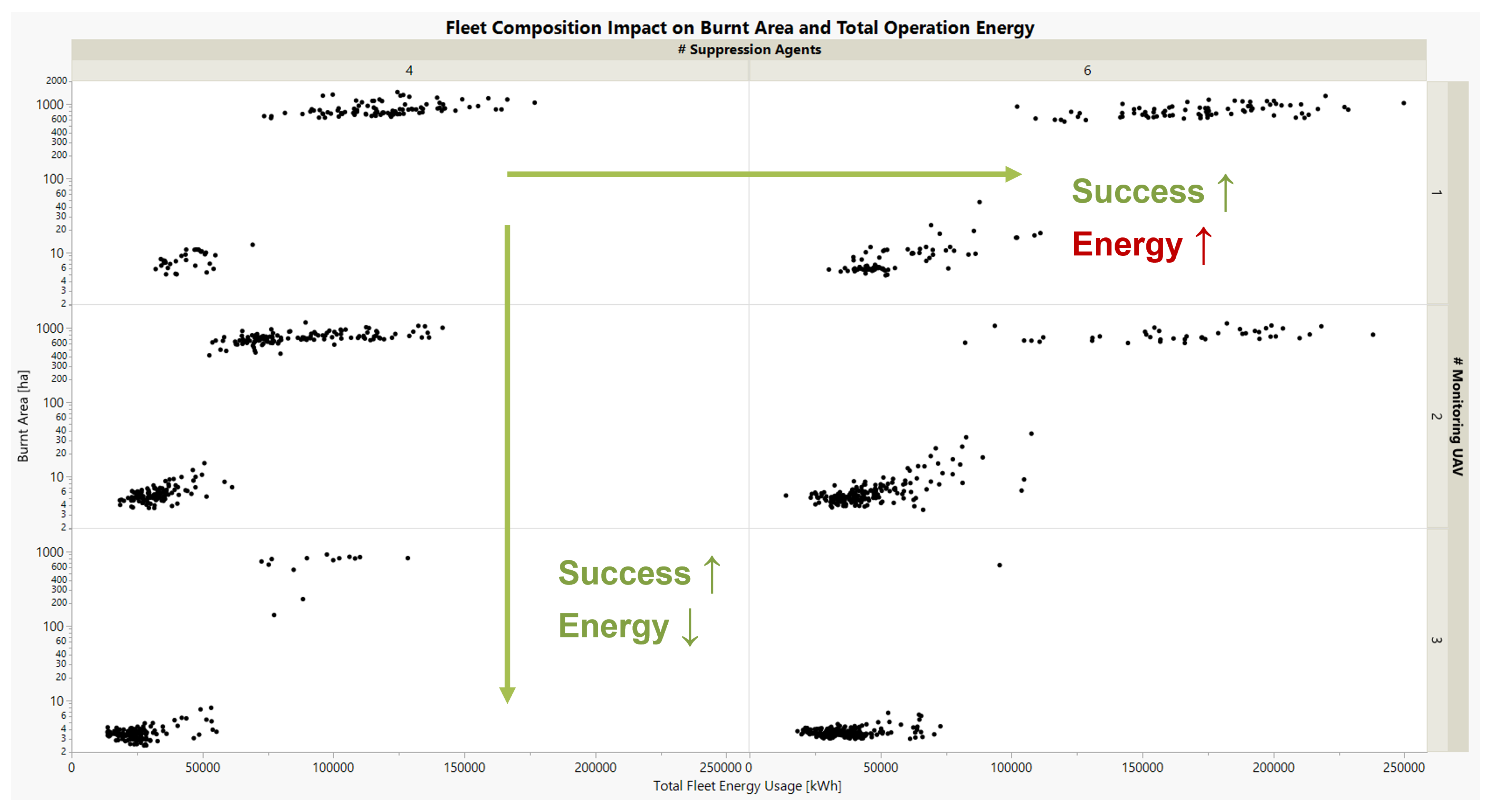
From the comparison with the baseline, it is intriguing to further investigate the fleet size composition, both of monitoring UAVs and DHC-515 aircraft to understand the dynamics and trade-offs between their performance and potential acquisition costs. This is done by comparing the burnt area, representing missions performance and total energy usage (considering fuel) of the fleet, as done in Figure 4. Each point is a different SoS architecture using the different UAV designs explored in Figure 3.
Figure 4.
Fleet composition trade-offs between monitoring agents and suppression agents.
Intuitively, missions where the burnt area is high typically result in a high energy usage, so operators would aim to ensure a low burnt area with a low energy usage. Of course, the best performing solution is the one with the greatest fleet of monitoring UAVs providing updates and many suppression agents containing the fire. The consequence of increasing the suppression agents is not typical, however. If there are few monitoring agents, the benefit of increased suppressions is lost as fire front knowledge capture is limited. It is more beneficial to increase the monitoring UAV fleet size than the DHC-515, as evidenced by the burnt area (−63%) and energy reductions (34%) with three UAVs and four DHC-515s compared to two UAVs and six DHC-515s. This analysis, though preliminary, still highlights trends in collaborative behavior, with the importance of knowledge capture being greater than suppressive power, which can support informed decision making.
Therefore, this study justifies the need to design UAV networks and the SoS as a whole over simply improving firefighting aircraft designs when it comes to improving wildfire disaster relief. Future studies expanding the variety of scenarios and extending the aircraft design considerations of the UAVs and firefighting aircraft could be fruitful to supporting this conclusion.
4. Conclusions
The purpose of this study was to expand state-of-the-art research into wildfire monitoring and surveillance, specifically looking at communication and collaboration between monitoring systems and suppression tasked systems in the wildfire SoS. This was achieved by expanding the SoSID Toolkit with monitoring UAVs which work on a task system prioritizing fire front exploration and tracking paired with data storage and sharing. Based on a sample mission from the EU COLOSSUS Project, the monitoring agent implementation was verified to work at a similar level to omniscient fire front knowledge where all fire locations and spread rates are known at all times. A framework was presented which pairs agent design traits and operational strategy for the wildfire SoS, facilitating informed decision-making processes. In doing so, the exploration of the monitoring agent design highlighted key parameters that have the greatest significance on the mission success, that being the swath radius, with communication frequency gaining importance with fewer UAVs in the fleet. An intriguing result was the impact of monitoring UAV fleet size, where an increase from two to three UAVs provided a greater benefit than increasing the suppression agents from four to six, as evidenced through a reduction in burnt area but also the fleet’s combined energy usage, indicating the importance of knowledge and surveillance in wildfire fighting operations.
Author Contributions
Conceptualization, methodology, development, writing, validation: N.K. Review, editing, supervision: N.N. and P.S.P. Project administration, funding acquisition: P.S.P. All authors have read and agreed to the published version of the manuscript.
Funding
The research presented in this paper has been performed in the framework of the COLOSSUS project (Collaborative System of Systems Exploration of Aviation Products, Services and Business Models) and has received funding from the European Union Horizon Europe program under grant agreement No. 101097120. The Swiss participation in the Colossus project is supported by the Swiss State Secretariat for Education, Research and Innovation (SERI) under contract number 22.00609.
Institutional Review Board Statement
Not applicable.
Informed Consent Statement
Not applicable.
Data Availability Statement
Data availability is limited to this paper. For further inquiries into the simulation and framework, visit the COLOSSUS Project webpage or contact the associated authors.
Conflicts of Interest
The authors declare no conflicts of interest.
Abbreviations
The following abbreviations are used in this manuscript:
| SoS | System-of-systems |
| ABM | Agent-based modeling |
| UAV | Unmanned aerial vehicle |
| SoSID | System-of-Systems Inverse Design (Toolkit) |
| IoT | Internet of Things |
| DoE | Design of experiments |
References
- Shahparvari, S.; Bodaghi, B.; Roozbeh, I.; Mohammadi, M.; Soleimani, H.; Chhetri, P. A cooperative (or coordinated) multi-agency response to enhance the effectiveness of aerial bushfire suppression operations. Int. J. Disaster Risk Reduct. 2021, 61, 102352. [Google Scholar] [CrossRef] [Scilit]
- Prakasha, P.S.; Naeem, N.; Amadori, K.; Donelli, G.; Akbari, J.; Nicolosi, F.; Franzén, L.K.; Ruocco, M.; Lefebvre, T.; Nagel, B. COLOSSUS EU Project–Collaborative SoS Exploration of Aviation Products, Services and Business Models: Overview and Approach. In Proceedings of the ICAS Congress 2024, Florence, Italy, 9–13 September 2024. [Google Scholar]
- Prakasha, P.S.; Naeem, N. Establishing a Collaborative Open Source Agent Based Simulation Environment for System of Systems Aviation Problems. CEAS Aeronaut. J. 2025; submitted.
- Kilkis, S.; Prakasha, P.S.; Naeem, N.; Nagel, B. A Python Modelling and Simulation Toolkit for Rapid Development of System of Systems Inverse Design (SoSID) Case Studies. In Proceedings of the AIAA AVIATION 2021 FORUM, Online, 2–6 August 2021. [Google Scholar] [CrossRef] [Scilit]
- Boroujeni, S.P.H.; Razi, A.; Khoshdel, S.; Afghah, F.; Coen, J.L.; O’Neill, L.; Fule, P.; Watts, A.; Kokolakis, N.M.T.; Vamvoudakis, K.G. A comprehensive survey of research towards AI-enabled unmanned aerial systems in pre-, active-, and post-wildfire management. Inf. Fusion 2024, 108, 102369. [Google Scholar] [CrossRef] [Scilit]
- Zadeh, R.B.; Elmi, A.; Moghaddam, V.; MahmoudZadeh, S. A Conceptual High Level Multiagent System for Wildfire Management. IEEE Trans. Geosci. Remote Sens. 2025, 63, 5911415. [Google Scholar] [CrossRef] [Scilit]
- Wu, X.; Fu, Y.; Qiao, L.; Dong, H.; Qin, Q.; Dilfanian, E.; Taherzadeh, A.; Zhang, Y.; Benzerrouk, H.; Guiddir, H. An Intelligent Algorithm for Determining Optimal Wildfire Suppression Zone Using UAV. In Proceedings of the 2025 IEEE 19th International Conference on Control and Automation (ICCA), Tallinn, Estonia, 30 June–3 July 2025. [Google Scholar] [CrossRef] [Scilit]
- Julian, K.D.; Kochenderfer, M.J. Distributed wildfire surveillance with autonomous aircraft using Deep Reinforcement Learning. J. Guid. Control Dyn. 2019, 42, 1768–1778. [Google Scholar] [CrossRef] [Scilit]
- Al-Husseini, M.; Wray, K.H.; Kochenderfer, M.J. Hierarchical framework for optimizing wildfire surveillance and suppression using human-autonomous teaming. J. Aerosp. Inf. Syst. 2024, 21, 790–811. [Google Scholar] [CrossRef] [Scilit]
- Rui, X.; Hui, S.; Yu, X.; Zhang, G.; Wu, B. Forest fire spread simulation algorithm based on cellular automata. Nat. Hazards 2017, 91, 309–319. [Google Scholar] [CrossRef] [Scilit]
- Kalliatakis, N.; Naeem, N.; Shiva Prakasha, P.; Nagel, B. Improving aerial wildfire fighting effectiveness using future climate sensitivities and novel aircraft concepts. In Proceedings of the Research and Education in Aircraft Design 2024, Warsaw, Poland, 6–8 November 2024. [Google Scholar]
- Prakasha, P.S.; Naeem, N.; Kalliatakis, N.; Nagel, B. Evaluation of Current and Next-Gen Aircraft in a European Wildfire Scenario. In Proceedings of the EASN Conference 2024, Thessaloniki, Greece, 8–11 October 2024. [Google Scholar]
Disclaimer/Publisher’s Note: The statements, opinions and data contained in all publications are solely those of the individual author(s) and contributor(s) and not of MDPI and/or the editor(s). MDPI and/or the editor(s) disclaim responsibility for any injury to people or property resulting from any ideas, methods, instructions or products referred to in the content. |
© 2026 by the authors. Licensee MDPI, Basel, Switzerland. This article is an open access article distributed under the terms and conditions of the Creative Commons Attribution (CC BY) license.