


Abstract
The archaeological reconstruction of historic monuments from fragmentary remains requires transforming limited evidence into verifiable hypotheses. This study proposes a methodological framework in which structural analysis plays an active interpretative role, rather than serving merely as verification, provided that input data are independently constrained and modelling assumptions align with the available level of knowledge. The framework is designed to be replicable and transferable to archaeological contexts characterised by incomplete preservation. It combines non-invasive survey techniques—high-resolution digital documentation and ground-penetrating radar (GPR)—to establish reliable geometric and physical constraints. Thrust-based limit analysis, following the Heyman Safe Theorem, is then applied to evaluate reconstruction hypotheses through static equilibrium under self-weight. The methodology is tested on the cavea of the Circus of Maxentius in Rome, a Roman concrete construction in which significant portions of the vaulted substructure are collapsed or buried. Three typological cross-sections are virtually reconstructed using construction-archaeology reasoning, measured geometry, and geophysical evidence. Their stability is assessed through thrust-line admissibility and geometric safety factors. Only one section approaches limit equilibrium when analysed independently, while the others prove inadmissible, suggesting that rear backfills, transverse supporting walls near the imperial corridor, and vaulted structures were essential to the original structural system. Overall, the study demonstrates how integrating non-invasive data and limit analysis reduces interpretative uncertainty in reconstructing partially preserved Roman architecture.
1. Introduction
The interpretation and reconstruction modelling of partially preserved historical constructions represent a central challenge in architectural heritage research [1,2,3,4]. When monuments survive only in a fragmentary state—due to collapse, burial, or loss of substantial portions—the reconstruction of their original configuration inevitably relies on hypotheses. In such contexts, the critical issue is not only historical plausibility, but also structural consistency: reconstruction hypotheses may appear geometrically convincing while being mechanically untenable, or conversely may be structurally analysed on the basis of speculative or weak assumptions. This problem is particularly acute for large-scale Roman constructions, whose original structural systems are often only partially readable and whose materials, such as Roman concrete, are intrinsically heterogeneous [5]. The lack of direct information on construction details, the geometry of collapsed or buried elements, and the mechanical properties of materials at the time of construction constitutes a major knowledge gap, significantly constraining both reconstruction and analysis.
In recent years, virtual reconstruction has increasingly been framed within the broader field of digital heritage [6], in which three-dimensional models are no longer regarded merely as visual representations, but as structured environments for integrating geometric, historical, archaeological, material, and diagnostic information. Historic Building Information Modelling (HBIM) has played a central role in this transition by associating survey-derived geometries with semantic and documentary information [7]. More recently, heritage-oriented digital twins have further extended this concept by linking digital representations to heterogeneous datasets, monitoring systems, analytical models, and decision-support procedures [8,9]. Nevertheless, the application of HBIM and digital-twin concepts to archaeological structures remains challenging because the geometry and construction of lost components cannot be directly observed and must instead be inferred from incomplete and heterogeneous evidence [10]. Consequently, information-rich modelling does not in itself guarantee the reliability of a reconstruction, unless the distinction between measured data, interpretative assumptions, and hypothetical elements is explicitly maintained.
Parallel developments in artificial intelligence and computational reconstruction are introducing increasingly automated procedures for feature recognition, geometric completion, classification, and the generation of alternative reconstruction hypotheses [11,12]. Although these methods can accelerate the processing of large and heterogeneous datasets, AI-assisted outputs remain dependent on the representativeness of training data, the assumptions embedded in the algorithms, and the quality of archaeological supervision. This is particularly relevant for fragmentary architecture, where geometrically convincing reconstructions may conceal substantial epistemic uncertainty. Recent research has therefore emphasised the need for traceable and uncertainty-aware reconstruction workflows, in which the provenance and reliability of each reconstructed element are documented and, where possible, expressed through qualitative classes, numerical indicators, or alternative scenarios. From this perspective, structural analysis can provide an additional and independent constraint: it cannot uniquely determine the original configuration, but it can test whether a reconstruction hypothesis is mechanically admissible and exclude configurations that are inconsistent with equilibrium.
Over the past decades, the study of historical constructions has increasingly adopted interdisciplinary approaches combining building archaeology, architectural survey, material studies, and structural analysis [13,14,15,16]. Within this framework, structural analysis has progressively shifted from a purely verificatory role (applied a posteriori to a predefined geometry) towards a more interpretative function, capable of informing, constraining, and sometimes falsifying virtual reconstruction hypotheses [17,18]. However, the effectiveness of structural analysis in supporting archaeological interpretation is strongly dependent on the reliability of the input data on which the model is based. Geometry, material properties, boundary conditions, and load assumptions all play a key role in determining the outcomes of any structural assessment. When these inputs are poorly constrained, the analysis risks becoming circular, implicitly validating the several assumptions on which it relies [19]. This dependency is particularly problematic in archaeological contexts, where missing or buried elements are often virtually reconstructed through analogies, proportional rules, or stylistic considerations, and where conservation constraints frequently preclude invasive investigations aimed at material characterisation.
In parallel with the developments in structural analysis, major progress has been achieved in non-invasive survey and diagnostic techniques for cultural heritage. High-resolution digital survey methods—such as terrestrial [20] and air-borne [21] laser scanning and photogrammetry [22,23]—enable accurate documentation of standing remains and the generation of detailed three-dimensional geometric models suitable for metric, typological, and structural interpretation.
At the same time, geophysical techniques and, in particular, ground-penetrating radar (GPR), have become increasingly widespread in archaeological research [24,25]. GPR allows the detection and interpretation of buried architectural elements, collapse deposits, voids, and subsurface stratigraphy without excavation, providing crucial information on portions of a structure that are no longer visible. Recent advances include multi-channel and three-dimensional acquisition, improved migration and attribute-based analysis, data fusion with other geophysical and spatial datasets, and machine- and deep-learning procedures for the enhancement, segmentation, and classification of archaeological anomalies [26,27]. These developments can improve the readability and consistency of complex datasets, although archaeological interpretation still requires expert supervision and integration with stratigraphic, architectural, and historical evidence. Despite these advances, GPR results are still rarely incorporated as explicit geometric constraints within structurally driven virtual reconstruction workflows.
Within this context, the choice of the structural modelling approach becomes a crucial methodological issue [28,29]. Many advanced numerical methods commonly adopted in structural engineering require an extensive set of mechanical and constitutive parameters in addition to geometry and density. Amongst all the numerical modelling methods, continuum-based approaches, such as the Finite Element Method (FEM) [30,31,32,33], model the structure as a homogeneous elastic or elastoplastic body and require reliable estimates of elastic moduli, strength parameters, and failure criteria. In the case of Roman concrete and ancient masonry, the strong heterogeneity of the material—resulting from variability in aggregate composition, size, and distribution—renders the assumption of homogeneity highly questionable. Moreover, the characterisation of mechanical properties would require invasive or destructive testing, often incompatible with conservation requirements. Even when such tests are feasible, they only provide limited information on specific parts of the building regarding current and aged materials, whereas structural behaviour should ideally be assessed with reference to the properties at the time of construction, which cannot be directly recovered. Discrete Element Methods (DEMs) [34,35,36,37], while conceptually appealing for discontinuous systems, present similar limitations. The subdivision of Roman concrete vaults into blocks is largely hypothetical, and the definition of interface constitutive laws requires parameters such as friction, cohesion, and tensile resistance, which are again difficult to estimate reliably for highly heterogeneous ancient materials. In this sense, the use of highly complex structural models risks being poorly effective: increasing model sophistication does not compensate for the uncertainty and weakness of the input data, and may even obscure the interpretative value of the analysis.
In contrast, the static approach of limit analysis, as formalised by the Heyman’s Safe Theorem [38,39], proves particularly well suited to the study of ancient and monumental constructions under severe knowledge constraints. In this framework, the structure is modelled as a rigid body, or an assemblage of rigid bodies, unable to resist tension, with infinite compressive strength and no sliding between blocks. Once the geometry is defined, the only additional input required is the weight of the materials, which can be reasonably estimated from archaeological and historical sources. Structural safety is assessed by verifying that a thrust line in equilibrium with the applied loads lies entirely within the thickness of the structure, while the level of safety can be quantified through a geometric safety factor [40,41]. These simplifying assumptions are not only consistent with the predominantly compressive behaviour of massive Roman masonry and concrete structures, but also closely aligned with the type of information that can be reliably obtained through non-invasive investigations. As a result, limit analysis does not aim to provide a detailed simulation of material behaviour, but rather a robust assessment of static admissibility, making it particularly effective for evaluating the plausibility of virtual reconstruction hypotheses.
Within this evolving digital-heritage landscape, a significant methodological gap therefore remains between the generation of increasingly detailed and information-rich virtual models and the physical assessment of the hypotheses embedded within them. HBIM, digital twins, AI-assisted reconstruction, and uncertainty-visualisation methods can improve data organisation, interoperability, automation, and transparency; however, they do not generally test whether a reconstructed architectural configuration is compatible with the original load-transfer mechanisms. The present study addresses this gap by combining survey-derived geometry, archaeological interpretation, subsurface GPR evidence, and thrust-based limit analysis. The resulting framework is conceived not as an automatic reconstruction procedure, but as a transparent hypothesis-testing process in which alternative configurations can be constrained, compared, and, when mechanically inconsistent, rejected.
2. Aim and Objectives
The main aim of this paper is to propose a reliable and efficient methodological framework for the use of structural analysis in support of archaeological interpretation and reconstruction hypotheses of partially preserved historical constructions. In particular, the research seeks to demonstrate how structural analysis can move beyond a purely verificatory role and become an active component of the interpretative process, provided that it is based on reliable input data and on modelling assumptions consistent with the level of available knowledge.
To this end, the paper pursues the following specific objectives:
- To define an integrated approach that can be as replicable and standardisable as possible, allowing its application to different archaeological contexts characterised by incomplete preservation and limited material information;
- To demonstrate the importance and the impact of non-invasive survey techniques, such as high-resolution digital survey and ground-penetrating radar, in providing robust geometric and physical input data for structurally driven archaeological reconstruction hypotheses;
- To test the proposed methodological framework on a representative case study, the Circus of Maxentius, a 4th-century AD Roman hippodrome situated along the ancient Appian Road in Rome, Italy, assessing its effectiveness in guiding and validating archaeological reconstruction hypotheses through static equilibrium criteria.
3. Proposed Methodology
The proposed methodology is conceived as an integrated and interdisciplinary framework aimed at supporting archaeological interpretation and virtual reconstruction hypotheses of partially preserved historical constructions through structural reasoning. The core assumption is that structural analysis can meaningfully contribute to reconstruction processes only if it is grounded on reliable, independently acquired input data and on modelling approaches compatible with the level of uncertainty inherent in archaeological contexts.
The method, illustrated in Figure 1, is structured as an iterative workflow articulated into three main phases:
- Non-invasive survey and data acquisition;
- Formulation of geometrically constrained virtual reconstruction hypotheses;
- Static structural assessment through limit analysis.
Figure 1.
Graphical workflow of the proposed methodology.
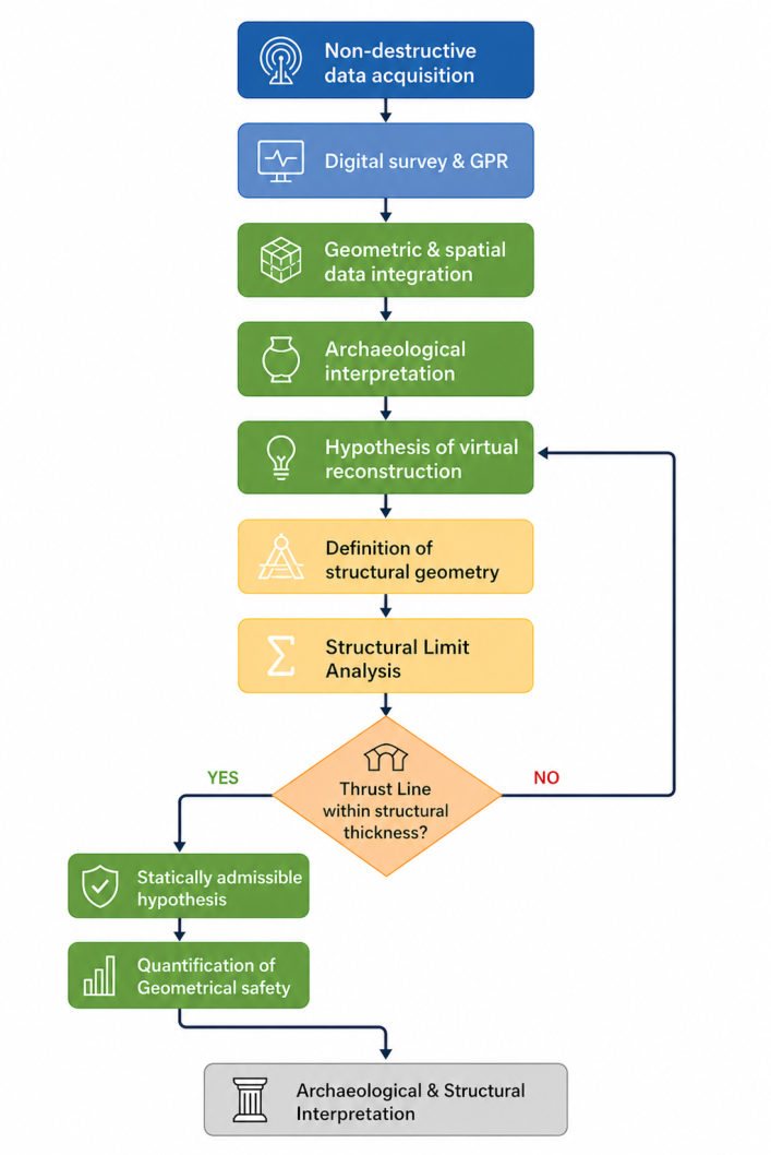
Each phase informs and constrains the others, allowing reconstruction modelling and structural evaluation to evolve jointly rather than sequentially.
3.1. Non-Invasive Survey and Geometric Data Acquisition
The first phase focuses on the acquisition of reliable geometric and morphological information on both standing and non-visible portions of the structure. Priority is given to non-invasive techniques in order to comply with conservation constraints and to maximise the amount of information obtainable without physical intervention.
High-resolution digital survey techniques, such as terrestrial laser scanning and terrestrial or aerial photogrammetry, are employed to document the geometry of preserved elements with a high degree of metric accuracy. The resulting point clouds and three-dimensional models provide a robust geometric basis for typological analysis, section identification, and structural interpretation.
To complement the survey of emergent remains, geophysical techniques are used to investigate buried, collapsed, or otherwise inaccessible structural components. Among these, GPR plays a central role, as it allows the identification of subsurface architectural features, foundation levels, collapse deposits, and voids without excavation. The integration of GPR data with digital survey outputs enables a more comprehensive understanding of the spatial configuration and stratigraphic relationships of the structure.
The outcome of this phase is a set of geometrically and spatially consistent datasets that constrain the possible configurations of missing or collapsed elements, reducing the reliance on purely speculative reconstructions.
3.2. Formulation of Reconstruction Hypotheses
Based on the survey data and on building archaeology knowledge, one or more virtual reconstruction hypotheses are formulated for the missing or partially preserved structural components. This phase does not aim to produce definitive virtual reconstructions, but rather at defining geometrically coherent and archaeologically plausible configurations that are compatible with the available evidence.
The formulation of hypotheses is guided by:
- The geometry of preserved elements and their constructional logic;
- Recurring typological features observed in comparable historical structures;
- Subsurface information derived from geophysical investigations.
At this stage, virtual reconstruction hypotheses remain provisional and are explicitly conceived as testable assumptions. Their credibility is not assessed solely on formal or stylistic grounds, but is subjected to verification through structural equilibrium conditions in the subsequent phase.
3.3. Structural Modelling Under Knowledge Constraints
Structural assessment is performed adopting modelling strategies explicitly tailored to contexts characterised by limited and uncertain material information. Rather than relying on highly parameterised numerical models, the methodology prioritises approaches that minimise input requirements while retaining physical meaning.
In this framework, the static approach of limit analysis, as formalised by Heyman’s Safe Theorem, is adopted. The structure is idealised as a rigid body, or an assemblage of rigid bodies, incapable of resisting tensile stresses and endowed with infinite compressive strength. Sliding between blocks is neglected, and material behaviour is not described through elastic or strength parameters.
Once the geometry of the virtually reconstructed configuration is defined, the only required mechanical input is the weight density of the materials, which can be reasonably estimated from archaeological, historical, or literature sources. This makes the approach particularly suitable for ancient masonry and Roman concrete structures, whose heterogeneity and long-term ageing render detailed mechanical characterisation highly uncertain or impractical, as demonstrated by several applications in the literature [42,43,44,45].
The aforementioned assumptions should not be understood as a constitutive description of Roman concrete, but as an idealisation of its cracked or long-term degraded condition, in which equilibrium is mainly ensured through compression. In particular, the subdivision into rigid units is purely fictitious and serves only as a mechanical and graphical discretisation for constructing an admissible thrust line; it does not reproduce the actual arrangement of aggregates, construction layers, blocks, or discontinuities within the Roman concrete mass, and the idealised interfaces should not be interpreted as physical joints. The no-tension assumption neglects possible residual cohesion, infinite compressive strength excludes local crushing, and the no-sliding condition presupposes sufficient friction and mechanical interlocking for compressive force transfer. Moreover, the rigid-body idealisation does not account for deformation or progressive cracking.
Consistently with previous applications to Roman concrete and vaulted historical constructions [44,45], the method is therefore intended to assess global static admissibility rather than to reproduce the complete material response or the actual collapse process.
3.4. Static Assessment Through Graphic Statics and Limit Analysis
Structural safety and admissibility are assessed by verifying the existence of a thrust line in equilibrium with the applied loads that lies entirely within the thickness of the structural elements. Graphic statics is employed as the operative tool for implementing the Safe Theorem, allowing a clear and transparent representation of force equilibrium and internal force paths.
The position of the thrust line provides a direct criterion for evaluating the static admissibility of an archaeological reconstruction hypothesis. When the thrust line remains within the structural thickness, the configuration is considered statically admissible; when it exits the section, the hypothesis is structurally inconsistent under the assumed conditions.
In addition to a qualitative assessment, the level of safety can be quantified through a geometric safety factor, defined as the ratio between the semi-thickness of the structural element and the eccentricity of the thrust line at the section of [40,41]. This indicator allows different reconstruction hypotheses to be compared on a rational and physically grounded basis.
3.5. Iterative Refinement and Validation of Hypotheses
The proposed methodology is inherently iterative. Structural assessment outcomes are not interpreted as definitive validations, but as feedback that may confirm, refine, or invalidate the proposed archaeological reconstruction hypotheses. When equilibrium conditions are not satisfied, the virtual reconstruction is revised by incorporating alternative geometric configurations, additional supporting elements, or different boundary conditions, provided that they remain compatible with archaeological and survey evidence.
Through this iterative process, structural analysis becomes an active component of archaeological interpretation, contributing to the selection of reconstruction hypotheses that are not only historically and geometrically plausible but also mechanically consistent.
4. Application to the Case Study
4.1. The Circus of Maxentius
The Circus of Maxentius, located along the ancient Via Appia in Rome, forms part of the monumental imperial complex traditionally known as the Villa of Maxentius. Built in the early fourth century AD, the circus represents one of the best-preserved examples of Roman circus architecture, as its entire perimeter is still extant and several key architectural components—such as the carceres (starting gates from which the chariots set off), the spina foundations, and the perimeter walls of the cavea (grandstands)—remain clearly readable in Figure 2a,b [46].
Figure 2.
Circus of Maxentius in Rome: (a) aerial view and (b) plan and front view of the sector of interest.
Despite this exceptional state of preservation at the macro-scale, this monument presents significant challenges from an archaeological and structural point of view.
In particular, the cavea are almost entirely collapsed, and large portions of their original structural system are currently buried beneath soil deposits and collapse material. As a result, the original configuration of the vaulted substructures supporting the seating tiers is only partially documented through standing remains, while crucial information must be inferred from indirect archaeological and geophysical evidence.
More specifically, the present analysis mainly focuses on the north-western sector of the cavea, named as S1, extending from the carceres to the eastern edge of the pulvinar—the imperial viewing platform (Figure 2a,b).
This portion of the monument can be further subdivided into the three sub-sectors—SS1.1, SS1.2 and SS1.3—illustrated in Figure 2b, each corresponding to a distinct typological cross-section of the cavea, as further described in Section 4.3.
4.2. Open Questions
Several open research questions remain central to the virtual reconstruction and interpretation of the cavea. A first issue concerns the original configuration of the cavea, including the sub-cavea space. Archaeological evidence does not conclusively clarify whether the space beneath the seating tiers was conceived as an empty ambulacrum system, articulated by vaulted corridors, or whether it was at least partially filled with soil or rubble, either from the outset or as a result of later transformations. This distinction has significant implications not only for the functional interpretation of the monument, but also for the assessment of the original load paths and structural equilibrium of the cavea.
A second unresolved question relates to the possible presence of rear fillings or buttressing structures behind the external perimeter wall of the cavea. Structural considerations, combined with the absence of openings in the outer wall and with geophysical indications of buried masses, suggest that additional supporting elements or earth embankments may have existed to counteract the horizontal thrust of the vaulted substructures. However, the extent, geometry, and constructional logic of such features are still poorly constrained and require further investigation.
Finally, the widespread use of amphorae embedded within the Roman concrete of the vaulted structures remains an open hypothesis. While the presence of amphorae in Roman concrete is well attested in other contexts, their functional role in the Circus of Maxentius remains debated [42,46]. It is still unclear whether their use should be interpreted primarily as a strategy for material saving or weight reduction, as a constructional expedient related to curing and drying processes, or as an element with potential structural implications for the behaviour of the vaults.
These unresolved issues make the Circus of Maxentius an especially suitable case study for testing integrated methodological approaches aimed at supporting virtual reconstruction hypotheses through the combined use of non-invasive survey techniques and structurally informed analysis. The monument thus provides an ideal framework for exploring how archaeological interpretation and structural reasoning can be jointly employed to reduce uncertainty and improve the reliability of theoretical reconstructions of partially preserved ancient architecture.
4.3. Photogrammetric Survey
A close-range photogrammetric survey was carried out to generate a scaled and spatially referenced three-dimensional digital model of the archaeological remains within the investigated sector. The primary objective of the survey was to obtain a metrically reliable geometric representation of the preserved structures, suitable for architectural analysis, cross-section extraction, and subsequent structural interpretation.
Image acquisition was performed using a high-resolution Olympus E-M10 Mark II digital camera equipped with an Olympus M.Zuiko Digital ED 14–150 mm lens, operated at focal lengths of 14 and 15 mm. A total of 673 images, with a resolution of 4608 × 3456 pixels, were acquired and successfully aligned. Photographs were acquired following a systematic protocol, with an overlap of approximately 40% between consecutive images. The use of repeated and convergent viewpoints provided high image redundancy, with most of the surveyed surfaces being visible in more than nine images. The resulting average ground sampling distance (GSD) was approximately 0.85 mm/pixel.
For architectural elements located at higher elevations or partially obscured when observed from ground level, such as the upper portions of the cavea or the remains of seating coverings, a telescopic pole was employed. This device allowed the camera to be raised and oriented appropriately, enabling the acquisition of images from elevated viewpoints while maintaining controlled shooting geometry and adequate overlap with ground-based photographs. The combined use of terrestrial and elevated image acquisition contributed to a more complete and homogeneous coverage of the surveyed surfaces.
Photogrammetric processing was performed using Agisoft Metashape Professional 2.3.0. Since the camera was not pre-calibrated, the interior orientation and lens-distortion parameters were estimated separately for the image groups acquired at focal lengths of 14 and 15 mm during bundle adjustment. The image alignment generated 261,510 tie points and approximately 1.78 million image projections, with a mean reprojection error of 1.41 pixels.
The photogrammetric model was subsequently scaled and referenced within a local metric coordinate system using topographic data acquired with a digital total station. Forty targets positioned on the archaeological remains were accurately measured in three-dimensional space and used as ground control points (GCPs) during photogrammetric processing. The resulting control-point RMSE was 2.42 mm, including an XY error of 2.40 mm and a vertical error of 0.35 mm. Since no independent check points were available, these residuals represent the internal consistency of the model referencing rather than an independent estimate of absolute geometric accuracy. The final high-density point cloud consisted of approximately 150.5 million points, with a reported coordinate precision of 0.425 mm. The derived digital elevation model had a resolution of 1.91 mm/pixel and a point density of 27.5 points/cm2.
The resulting output is a high-resolution, scaled, and spatially referenced three-dimensional model of the surveyed sector (S1), which provides a comprehensive geometric documentation of the preserved remains. An overview of the complete photogrammetric model of the sector S1 is shown in Figure 3, where three characteristic cross-sections (CS) corresponding to sub-sectors SS1.1, SS1.2, and SS1.3 are highlighted, which are CS.1-1, CS.2-2 and CS.3-3, respectively. These sections form the geometric basis for the subsequent archaeological and structural analyses.
Figure 3.
Photogrammetric model of Sector S1, with extrapolated cross-sections (CS) highlighted.
4.4. GPR Acquisitions
GPR investigations were carried out to support the geometric and archaeological interpretation of the buried and collapsed portions of the cavea, with special attention to features that could not be directly observed through surface surveying. The GPR survey was conceived as a non-invasive diagnostic tool capable of providing indirect yet physically meaningful information on subsurface stratigraphy, structural remains, and collapse dynamics [47,48,49]. Given the absence of independent ground-truth validation, the interpretations proposed in the following subsections should be regarded as archaeologically informed hypotheses supported by the geophysical evidence, rather than as definitive proof.
Data acquisition was performed using three pulsed GPR systems, all manufactured by IDS Georadar S.p.A. A Hi-Mod system was used for investigations with variable depth expected, due to its dual-frequency ground-coupled antennas operating at central frequencies of 200 MHz and 600 MHz, whereas a TR80, bi-static ground-coupled antenna with operating central frequency of 80 MHz was employed for investigations with deeper target expected. Lastly, an air-launched horn antenna with 1000 MHz operating frequency was used for collecting data that were not reachable by contact antennas. The acquisition parameters adopted for the surveys are reported in Table 1.
Table 1.
GPR survey acquisition parameters.
Regardless of the employed antenna, a standard data-processing routine [50] has been adopted, including the following steps: time zero correction, trace alignment, bandpass filtering, amplitude gain, time-depth conversion. With regard to the time-depth conversion, the velocity of wave propagation has been calculated, where possible, through the hyperbola fitting method. In absence of clear hyperbolas, given the impossibility to carry out any excavation or core extraction, an average velocity of 10 cm/ns has been hypothesized.
The GPR survey was designed to address three main research objectives, described in the following sections, which required three separate data acquisition strategies.
4.4.1. Identification of the Foundation Level
The first objective was to identify the foundation level of the cavea structures. Detecting the depth and continuity of the foundation plane is essential for understanding the original structural layout and for constraining the vertical geometry of the virtually reconstructed sections. Attention was paid to identifying strong, continuous reflectors that could be interpreted as foundation surfaces or interfaces between construction layers and the natural substratum.
The test consisted of 12 linear scans acquired orthogonally with respect to the stands walls. As shown in Figure 4, six acquisitions (T1–T6) were carried out from the arena towards the inner wall (podium wall) of the cavea, while the other six (T7–T12) were acquired from the back-wall (external perimeter wall) of the stands. The whole dataset was collected in Sector 1 by hand-towing the TR80 GPR system (see Figure 4). The topographical position of the scan lines was defined by total station.
Figure 4.
Position of the GPR scans acquired for the identification of the foundation level. The yellow box highlights the area of investigation.
The analysis of the data, after the application of a standard processing routine, produced a clear indication of an abrupt change in material at approximately 2.0 m of depth, with a somewhat evident reflective interface. In this case, given the absence of clear hyperbolas in the radargrams, an average propagation velocity of 10 cm/ns was adopted. Even though this value complies with a dry vegetated soil, it is worth noting that it may be verified to be different from that hypothesised and range between 9 cm/ns (i.e., slightly humid soil) and 12 cm/ns (i.e., very dry vegetated soil). This reflects in an actual reflection depth ranging between 1.80 m and 2.40 m.
As a demonstration, scans T3 and T10, acquired at the same level of the structure but from the inside and outside of the grandstands, respectively, are plotted together with the cross-section obtained from the digital model in Figure 5.
Figure 5.
T3 and T10 radargrams positioned in correspondence with the relevant cross-section taken from the digital model.
Based on the observed GPR responses, it is reasonable to interpret the identified continuous reflector as corresponding to the foundation level of the cavea structures. The depth, continuity, and geometric coherence of this interface are consistent with what can be expected for a foundation plane associated with the construction of the grandstands.
The overlying stratigraphic layer is characterised by more heterogeneous reflection patterns, suggesting a material with variable composition and compaction. This upper layer can plausibly be interpreted as fill material, likely related to construction or levelling phases associated with the erection of the cavea. Such an interpretation is further supported by the widely accepted hypothesis that the present ground level does not substantially differ from the original Roman walking surface. Under this assumption, the thickness and stratigraphic position of the detected layer are compatible with intentional backfilling or preparatory deposits rather than with post-abandonment accumulation alone.
4.4.2. Detection and Characterization of Collapses
The second objective of the GPR investigation, related to the detection and characterization of collapsed structural elements, is to evaluate the state of the sub-cavea space at the time of collapse. Understanding the geometry, extent, and disposition of collapsed vault segments is essential for virtually reconstructing both the original configuration of the vaulted substructures and the mechanisms that led to their failure.
The GPR data addressing this objective were acquired using the same experimental setup adopted for the identification of the foundation level, in order to ensure consistency across the different investigative tasks. Surveys were carried out using a pulse-based GPR system equipped with a dual-frequency antenna (200–600 MHz), hand-towed along linear profiles at a constant acquisition speed and with regular trace spacing, ensuring uniform spatial sampling (Figure 6d).
Figure 6.
(a) Aerial view of the site; position of GPR scans in (b) Sector 1 and (c) Sector 2; (d) data collection.
Data acquisition was conducted in two distinct areas of the monument. The first corresponds to Sector 1, located in the north-western portion of the cavea and object of the structural analysis, where the majority of the other investigations were concentrated. The second area is located in the north-eastern sector (named as Sector 2 in Figure 6a), characterised by a higher ground elevation of the cavea. In both sectors, the acquisition lines were arranged so as to intersect the presumed direction of the vaulted substructures beneath the seating area, allowing anomalies related to collapsed elements to be identified through their characteristic geometric signatures (Figure 6b,c). The position of each scan line was recorded using a digital total station, enabling precise spatial correlation between GPR data, surface remains, and the photogrammetric digital model.
The analysis of the processed radargrams revealed several subsurface anomalies in both sectors, generally located at depths between approximately 1.0 m and 3.0 m. Hyperbola fitting allowed the estimate of the electromagnetic wave propagation velocity of 9.5 cm/ns. While it is important to state that this calibration is useful in determining the local dielectric properties and that, accordingly, a hypothesis on the homogeneity of the medium is still required, it is also worthy of note that the objective of this application was to reconstruct the shape and relative position of the collapses rather than to define the exact depth of burial. These anomalies are characterised by arcuate or inclined reflection geometries, locally associated with strong amplitude contrasts and signal discontinuities. Such features are consistent with the expected geophysical response of collapsed vault fragments that have undergone rotation and partial displacement while remaining embedded within collapse deposits (Figure 7). The confidence associated with this interpretation is comparatively high because the detected geometries were assessed against locally exposed collapsed vault portions, which provide direct archaeological and geometric analogues within the same construction. Nevertheless, arcuate or inclined reflections are not uniquely diagnostic of collapsed vaults and may also be generated by isolated masonry fragments, heterogeneous rubble deposits, voids, or marked contrasts in material composition and compaction.
Figure 7.
Processed radargrams (a) T14 and (b) T19 with the position of the collapsed vaults fragments highlighted.
A noteworthy result of the comparison between the two sectors concerns the depth at which the extrados of the collapsed vaults is detected. Despite the different ground elevations, the reflections attributable to the vault extrados are found at comparable depths (approximately 1.0 m below the present surface) in both Sector 1 and Sector 2. This observation suggests different collapse dynamics related to the original condition of the sub-cavea space. In Sector 1, the geometry and depth of the detected anomalies are compatible with a collapse occurring into a largely void ambulacrum, allowing the vault elements to experience a longer fall and a more pronounced rotation (Figure 7a). Conversely, in Sector 2, the shorter inferred collapse trajectory suggests that the ambulacrum was already partially filled at the time of failure (Figure 7b).
This interpretation is further supported by the observed disposition of the collapsed elements. In Sector 1, the detected anomalies exhibit greater rotation and displacement, whereas in Sector 2 the reflections appear more closely aligned with the original vault geometry. In several profiles, multiple reflective interfaces at different depths and orientations were identified, supporting the hypothesis of a progressive collapse process rather than a single localised failure event. While the identification of buried structural fragments is therefore well constrained, the inferred collapse trajectories and the distinction between an originally void and a partially filled ambulacrum remain interpretative hypotheses. Alternative explanations, including post-collapse redistribution, differential sediment accumulation, and local variations in preservation or burial conditions, cannot be entirely excluded.
4.4.3. Embedded Pottery Investigation
The third objective of the GPR investigation focused on the detection and characterization of amphorae embedded within the concrete of the vaults. The use of ceramic containers as lightweight inclusions in Roman concrete is documented in several architectural contexts [42]; however, their extent, distribution, and functional role within the cavea vaults remain open questions. High-frequency GPR investigations were therefore designed to identify electromagnetic signatures compatible with ceramic inclusions within the concrete mass (Figure 8a).
Figure 8.
Acquisition of GPR scans on collapsed vaults: (a) area of interest; (b) survey arrangement; (c) data acquisition. The yellow box highlights the area of investigation.
Data were acquired using a horn antenna with a central frequency of 1000 MHz, selected to optimise spatial resolution. The antenna was mounted on a wheeled trolley and oriented towards the intrados of the remaining vault segments (Figure 8b,c), maintaining an average distance of approximately 1.0 m from the surface. This configuration allowed for a controlled beam illumination of the vaults, particularly in areas where traces of embedded amphorae are directly visible.
For each investigated area, three parallel linear scans were acquired to illuminate different portions of the structure and reduce directional effects. The acquisition protocol was repeated in two adjacent areas of the same vault system (Figure 8a), allowing a comparative evaluation of potential variations in amphora density. Scan geometry and positioning were defined with reference to the photogrammetric digital model.
The analysis of the processed radargrams revealed a very dense set of high-amplitude reflections characterised by regular, sub-circular diffraction patterns, consistent with voids or low-permittivity ceramic inclusions embedded within a concrete matrix. The anomalies are organised along at least two distinguishable levels: a shallow level at depths lower than approximately 0.5 m from the vault surface, and a deeper level located at greater depths. Given the high density of hyperbolic diffractions observed in each radargram, multiple calibrations of the electromagnetic wave propagation velocity could be readily performed. The average estimated velocity was approximately 10.5 cm/ns, which is consistent with the dry Roman masonry—composed of tuff, brick, and Roman concrete—forming the vault [51]. The attribution of these anomalies to embedded amphorae is supported by direct comparison with ceramic vessels visible along exposed collapse surfaces and preserved portions of the vaults, which provide an in situ reference for both their dimensions and expected spatial arrangement. This correspondence, together with the regularity and density of the observed diffraction patterns, gives the interpretation a relatively high level of confidence. However, the response is not uniquely diagnostic of ceramic inclusions, since cavities, other low-permittivity objects, or strong local dielectric contrasts within the heterogeneous concrete matrix may produce comparable diffraction patterns. Accordingly, the GPR data are interpreted as strong evidence for the presence and distribution of amphorae, rather than as an exhaustive identification of every individual anomaly.
An example of a processed radargram is shown in Figure 9. Data processing included bandpass filtering, background removal and gain compensation, enabling a preliminary qualitative and quantitative assessment of their spatial distribution. The results indicate a spacing of approximately 0.75 m between pots located at the same level (within 1.00 m depth from the inspected collapse front line).
Figure 9.
Processed L1.2 radargram with evidence of regularly spaced reflections from in-concrete inclusions.
Overall, the observed distribution of anomalies, combined with the amphorae directly visible in exposed portions of the vaults, provides strong evidence for a systematic use of amphorae within the vault concrete. Nevertheless, the exact attribution of every individual reflection remains subject to the inherent non-uniqueness of GPR interpretation. These results provide important constraints for the virtual reconstruction of the original vault geometry and for subsequent structural analyses based on realistic material distributions.
4.5. Hypothesis of Virtual Reconstruction
4.5.1. Construction Archaeology and Building Logic
Three distinct constructional variations have been identified within the sector under investigation (S1), corresponding to as many sub-sectors of the structure (see Figure 2 and Figure 3 for reference). These variations, clearly discernible in the morphology of the ambulacrum, the vaults and in the organization of the superimposed elements, reflect different building solutions that can be associated with specific construction phases, functional requirements, or structural adaptations. The recognition of these sectors offers a fundamental framework for interpreting the construction logic of the complex. A general typological configuration of the reconstructed circus stand is reported in Figure 10, with structural elements being specified.
Figure 10.
As-built typological configuration of the circus stand.
The first sub-sector (SS1.1) corresponds to the northwestern portion, extending for approximately 78 m; here, the vault of the ambulacrum exhibits a fair state of preservation. The survival of a structural overhang allows for the direct observation of the horizontal profile of the intrados. This configuration is clearly legible in the spine wall separating the vaulted corridor from the distribution chamber located between the northwestern corner tower and the carceres. At this point, the remnants of the vault extend from the high impost for approximately 1.60 m with a flat profile (as further clarified in Section 4.5.2), before transitioning into a flying vault—a morphology that characterizes the remainder of the structure.
The second (SS1.2) and the third (SS1.3) sub-sectors show a different formal solution for the ambulacrum: here, the vault is entirely ramping, from the impost level, lacking the flat transitional segment observed in the northern sector. In a particularly well-preserved portion of the vault, a series of aligned holes has been identified immediately below the impost line, interpreted as housing for wooden joists. The 20 cm of masonry between these cavities and the springing of the vault was presumably intended to accommodate a sleeper beam, whose presence is evidenced by imprints still visible in the mortar and on the wall face.
The third sub-sector also features a markedly different configuration of the grandstand, as indicated by the visible traces on the concrete core: the seating is arranged only above the flying vault of the ambulacrum, with a higher step located in the central portion of the cavea, which divides it into upper and lower sectors. All sub-sectors are characterised by a large number of amphorae embedded within the concrete core of the vaults, the function of which is still widely debated.
The reasons underlying these constructional differences remain a complex and still-debated issue. They may relate to chronological discontinuities, changes in design, adaptations to local constraints, or evolving functional needs of the structure. In this perspective, a detailed structural analysis—such as the one undertaken in the present study—has the potential to offer a significant contribution to the understanding of these variations, helping to clarify their origin and their role within the overall building process.
4.5.2. Typological Cross-Sections and Geometric Assumptions
Based on the previously highlighted characteristics, derived from direct observation of the remains and an extensive survey, three virtual reconstructive proposals were developed and subsequently verified, one for each sub-sector (Figure 11 and Figure 12).
Figure 11.
Structural geometry of CS.1-1 (a) and CS. 2-2 (b). Dimensions in [m].
Figure 12.
Structural geometry of CS. 3-3 (a) and material properties of the stands (b). Dimensions in [m].
As anticipated in Section 4.5.1, each virtually reconstructed cross-section is defined, from a geometric and structural standpoint, by a system composed of two vertical supports—the podium and the external perimeter wall—and a flying vault spanning between them.
The first cross-section (CS. 1-1) (Figure 11a) corresponds to the sub-sector SS1.1 of the cavea and is characterised by a particularly articulated vault geometry. The intrados initially follows a typical ramping profile and then transitions into a horizontal segment, resulting in an upper springing level of approximately 4.42 m. The vault spans about 4.50 m, with a thickness of approximately 2.20 m at the springing, reducing to about 0.45 m at the point of maximum slenderness. The supporting elements consist of an external wall and a podium, with thicknesses of 1.26 m and 1.20 m, and heights (excluding parapets) of 7.60 m and 2.90 m, respectively. This sub-sector includes fourteen rows of seating and an underlying vaulted ambulatory approximately 4.51 m wide. Notably, numerous amphorae are embedded within the concrete mass above the springing of the vault, arranged vertically in multiple tiers (Figure 12b).
The second section (CS. 2–2) (Figure 11b), representative of the sub-sector SS1.2, maintains a similar span but exhibits a slenderer external pier, with a thickness reduced to 1.15 m. The vault in this case is entirely ramping, with no horizontal segment, and is characterised by a higher intrados springing level, reaching approximately 5.30 m. Its thickness varies from about 2.71 m at the lower springing to 1.68 m at the upper springing, tapering to approximately 0.65 m at mid-span. Although the seating arrangement is broadly comparable to that of Section CS.1–1, the different vault geometry and the reduced thickness of the external support result in a structurally more demanding configuration.
The third section (CS. 3–3) (Figure 12a) differs substantially from the previous two, reflecting its location in proximity to the imperial box (pulvinar). The most notable feature is the constant thickness of the external wall along its full height, due to the presence of the overlying imperial structure. This results in a larger external pier, with a thickness of approximately 1.34 m. The vault is fully ramping, with increased thickness compared to the other sections: approximately 2.70 m at the lower springing, 1.83 m at the upper springing, and about 0.85 m at mid-span. This sector is characterised by a reduced number of seating rows (approximately ten) and by a pronounced intermediate step separating the lower and upper cavea.
This geometric–structural idealisation provides the basis for the subsequent thrust line analyses, enabling a consistent comparison between the different configurations and an evaluation of their static admissibility.
4.5.3. Construction Materials and Structural Idealisation
The architectural programme promoted by Maxentius significantly transformed the local landscape, responding to the complex geomorphological conditions of the area [46]. The site is shaped by the ancient Capo di Bove lava flow, which generated a sequence of alternating valleys and plateaus. Within this context, the Circus is located in a natural depression bounded by two elevations.
From a constructional standpoint, the structural system of the cavea is primarily composed of opus caementicium (Roman concrete), consisting of tuff and brick aggregates bound by lime–pozzolan mortar [5]. The piers are complemented by a masonry facing made of tuff blocks, bricks, and lime mortar, with an average thickness of approximately 0.15 m. This facing also constitutes the parapets (Figure 12b).
A distinctive feature of cross-sections CS.1–1 and CS.2–2 is the presence of amphorae (types Dressel 20 and Dressel 23), embedded within the concrete mass at the interface between the vault and the external pier. Their presence has been confirmed through GPR investigations (see Section 4.4.3). The amphorae are arranged in two superimposed tiers, with an approximate spacing of 0.72 m in the upper row and 0.47 m in the lower one, the latter consisting of at least two nearly parallel alignments. In cross-section CS.3–3, no evidence of amphorae was detected through GPR; this absence is consistent with the different architectural configuration of sub-sector SS1.3, where the upper portion of the external pier corresponds to the podium of the imperial box.
To perform the structural analyses presented in Section 4.6, it was necessary to characterise the materials in terms of density. To this end, a series of samples was collected on site, primarily from collapse deposits attributable to the vaults. Prior to testing, the samples were cleaned to remove impurities and vegetation residues through water washing. Volume measurements were carried out using water displacement, with samples brought to full saturation to account for their high porosity. Subsequently, the specimens were oven-dried (48–72 h) to remove moisture before determining their dry weight.
The resulting density values were obtained as averages from three samples per material. Roman concrete exhibited a mean density of approximately 1420 , while mortar, brick, and tuff showed average densities of about 1350 , 1520 , and 1270 , respectively. The density of the masonry facing (approximately 1335 ) was estimated based on a representative geometric reconstruction of its layered composition.
It is important to note that the concrete samples were collected from collapsed vault fragments and can therefore be considered representative of the vault material. Conversely, no direct samples could be obtained from the piers, which are still standing, and whose heterogeneous nature would require invasive sampling to obtain statistically meaningful data. As a result, the density value derived for the concrete should be regarded as representative of the vaults, while the properties of the piers remain less constrained; this limitation is explicitly addressed in the structural analyses (Section 4.6).
All these geometric, constructional, and material assumptions define the reconstructed structural configurations, which are subsequently evaluated through limit analysis.
4.6. Structural Analysis
The structural analysis was designed to test the static admissibility of the archaeological reconstruction hypotheses defined in Section 4.5, explicitly addressing the gaps in knowledge discussed in Section 4.2. The objective is not to assess structural safety in a normative sense, nor to identify a unique original configuration, but to evaluate whether the proposed geometrical and constructional hypotheses are compatible with static equilibrium under self-weight. In this perspective, structural analysis is used as a constraint to the interpretation, allowing the exclusion of mechanically inconsistent hypotheses and the identification of configurations that require additional supporting elements.
The analyses were performed using the static approach of limit analysis based on Heyman’s Safe Theorem [38]. Each reconstruction hypothesis was analysed through representative two-dimensional cross-sections corresponding to the three typological sections (CS.1–1, CS.2–2, and CS.3–3). The structures were idealised as assemblies of rigid blocks, unable to resist tensile stresses, with infinite compressive strength and no sliding between blocks. The only mechanical input required by the model is the self-weight of the structural elements. Density values for Roman concrete, facing masonry, and other components were derived from laboratory measurements on representative samples and from archaeological data (see Section 4.5). Given the inherent uncertainty associated with material heterogeneity and sampling limitations, density values were treated as informed estimates and their influence was explored through comparative analyses.
For each cross-section, the structural elements were subdivided into fictitious blocks, for which self-weight and centroid position were calculated. Thrust lines were traced using graphic statics by imposing equilibrium under self-weight and by selecting, among the infinite admissible solutions, the configuration corresponding to minimum horizontal thrust at the springings of the vaults. This condition represents the most favourable scenario for the stability of the supporting piers (most suitable condition for the conclusions drawn in Section 5).
Static admissibility was assessed by verifying whether the thrust line remained entirely within the thickness of the structural elements. The level of stability was quantified through the geometric safety factor (SF) [40], defined as the ratio between the semi-thickness of the element and the eccentricity of the thrust line at the section under consideration. Values of SF ≥ 1 indicate static admissibility, whereas SF < 1 denotes structural inconsistency under the assumed conditions.
4.6.1. Main Results
The analytical results, discussed with reference to the virtually reconstructed typological sections and material configurations defined in Section 4.5 and described in greater detail in Section 5, show that none of the tested configurations achieves a condition of robust static admissibility when analysed as an isolated system. Even in the most favourable case (CS.1–1, Figure 13a), equilibrium is attained only in a near-limit condition, whereas cross sections CS.2–2 (Figure 14a) and CS.3–3 (Figure 13a) do not satisfy admissibility criteria under self-weight alone. For CS.1–1 (Figure 13a), the thrust line traced under minimum horizontal thrust conditions remains within the thickness of the structural elements but approaches the outer boundary of the external pier at its base. The resulting geometric safety factors, only slightly greater than unity, indicate a marginal equilibrium state. In light of these results, and consistent with the archaeological and geophysical evidence discussed in Section 4.4 and Section 4.5, it is reasonable to assume the presence of rear earth backfill or retained fill behind the external wall, which does not present any openings along the sub-sector SS1.1 (Figure 13b,c). Such a backfill would have provided an additional stabilising contribution by counteracting horizontal thrust, thereby moving the system away from the limit condition identified by the analysis.
Figure 13.
Structural analysis of CS.1-1: thrust line-drawing not in scale and dimensions in [m] (a) and possible pre-existence of backfill (b,c).
Figure 14.
Structural analysis of CS.2-2: thrust line-drawing not to scale and dimensions in [m] (a); evidence of pre-existing buttresses (b,c).
In the case of CS.2–2 (Figure 14b), the thrust line exits the base of the external wall for all tested material configurations, yielding geometric safety factors well below unity. The structural inconsistency of the isolated configuration suggests that the original equilibrium of this sector relied on the presence of dedicated supporting elements (Figure 14b,c). As indicated by the constructional analysis and supported by the extended structural assessment, these supporting elements can be more specifically interpreted as transverse masonry walls originally interposed between the cavea and the imperial corridor. Such walls would have been capable of ensuring the stability of the cavea in the investigated sector by acting as effective lateral restraints to the external wall. Their original presence is supported by both the planimetric reconstruction of the circus proposed by Ioppolo and Pisani Sartorio [46] and by direct material evidence observable on the outer face of the cavea wall, where discrete traces of wall abutments can be identified. The remains of these structures are, moreover, still clearly visible on site along the side of the imperial corridor (Figure 14c). On the basis of their geometric configuration and constructional relationships, these walls are interpreted as additions introduced during construction or in a subsequent phase, as also suggested by the partial occlusion of an original opening present in the external wall.
For CS.3–3 (Figure 15), the analysis highlights a similar inability to achieve admissibility when the section is considered in isolation, despite the increased thickness of the external wall. Given the proximity to the pulvinar, the results strongly suggest that the cavea vaults in this sector were structurally integrated with adjacent vaulted constructions associated with the imperial corridor platform (as demonstrated by Ioppolo and Pisani Sartorio planimetric reconstructions (Figure 15b,c)). The presence of such vaulted structures would have significantly modified the boundary conditions of the system, redistributing thrusts and reasonably allowing the overall configuration to reach static equilibrium.
Figure 15.
Structural analysis of CS.3-3: thrust line-drawing not to scale and dimensions in [m] (a); evidence of pre-existing vaulted structures (b,c).
Taken together, these results indicate that the cavea should be interpreted as part of a structurally interconnected system, in which rear backfills, buttressing elements, and adjacent vaulted constructions played an essential role in ensuring equilibrium. The limit analysis therefore does not contradict the archaeological evidence for such features, but rather provides a quantitative and physically grounded rationale for their necessity. Targeted comparative analyses performed on CS.1–1 further clarify the structural relevance of amphorae. As shown by the calculated values of horizontal thrust and geometric safety factor reported in the analytical results (Section 5.1), the inclusion of amphorae produces only marginal reductions in total weight and thrust, while slightly decreasing the SF of the external wall. These quantitative outcomes indicate that the amphorae visible in the constructional configuration were not used for structural stability functions.
4.6.2. Interpretative Significance and Methodological Limits
The outcomes of the analyses provide a physically grounded basis for interpreting the hypothesized reconstructed configuration. The marginal admissibility of CS.1–1 and the structural inconsistency of cross sections CS.2–2 and 3–3 strongly support the hypothesis that additional stabilising elements—such as rear backfill, transverse walls, or structures associated with the imperial corridor and the pulvinar—were integral components of the original static scheme of the cavea. At the same time, the results must be interpreted in light of the simplifying assumptions inherent to the adopted model. The analysis neglects tensile resistance, assumes idealised boundary conditions, is based on material properties evaluated only on specific locations of the structure, and relies on reconstructed geometries derived from incomplete evidence. Consequently, the reported safety factors and thrust values should not be interpreted as definitive measures of structural performance, but as indicators of static admissibility within a comparative and interpretative framework. Within these limits, limit analysis proves to be an effective tool for integrating archaeological hypotheses, non-invasive survey data, and structural reasoning into a coherent assessment of partially preserved Roman constructions.
The transferability of the proposed framework depends first on the availability and quality of the information used to constrain the reconstruction hypotheses. Its application requires a sufficiently reliable geometric representation of the preserved remains, obtained through metrically controlled survey techniques, together with independent evidence capable of constraining buried, collapsed, or inaccessible elements. Such evidence may derive from GPR, other geophysical methods, excavation records, archival documentation, construction archaeology, or well-founded typological comparisons. Survey data should provide a level of resolution compatible with the scale of the structural elements being reconstructed, while geophysical interpretations should be supported by appropriate acquisition geometry, velocity calibration, spatial positioning, and, where possible, cross-validation with visible or known features. The methodology is therefore transferable not because it prescribes a fixed set of instruments, but because it is based on a general principle: reconstruction hypotheses should be derived from traceable evidence and tested through a structural model whose complexity is consistent with the quality and completeness of the available data.
From a structural perspective, the workflow is most suitable for massive historic constructions whose behaviour is predominantly governed by compression and self-weight, such as masonry arches, vaults, retaining structures, Roman concrete substructures, and other gravity-based systems. Its reliability decreases when structural response is controlled by mechanisms that are not represented by the adopted limit-analysis assumptions, including significant tensile or flexural resistance, sliding, complex soil–structure interaction, material degradation with strongly localised effects, dynamic or seismic actions, or essential three-dimensional load-transfer mechanisms that cannot be represented through representative two-dimensional sections. The workflow may also be inappropriate where the surviving evidence is too limited to define a restricted and archaeologically meaningful range of geometric hypotheses, or where survey and geophysical data are too noisy, poorly georeferenced, or ambiguous to provide independent constraints. In such cases, structural analysis could produce apparently precise results that mainly reflect modelling assumptions rather than archaeological evidence. The proposed method should therefore be regarded as a hypothesis-testing framework, rather than as a universally applicable reconstruction procedure or a means of identifying a unique original configuration.
5. Results and Discussion
In this section, the results of the structural analysis are presented and critically discussed. The main outcomes are described in the text and summarised in Table 2. The table reports: the cross-section labels (CS.1-1, CS.2-2, CS.3-3); the depth of the analyzed sections along the third dimension; and the adopted concrete mass density configurations, namely A1420 (amphorae in the vault, uniform density 1420 ), S1420 (solid section, uniform density 1420 ), A1800P (amphorae in the vault, density 1800 for piers and 1420 for the vault), and S1800P (solid section, density 1800 for piers and 1420 for the vault). For each configuration, the table further includes: the total structural weight (and the corresponding percentage variation with respect to other configurations, ); the vault weight (with the percentage variation ); the horizontal component of the vault thrust (H) and its relative variation (); and the external wall weight and the geometrical safety factor at the base (SF), both reported with their respective percentage variations ( and ).
Table 2.
Comparison between configurations.
5.1. Structural Response of Cross-Section CS.1–1: Near-Limit Admissibility and Constructional Implications
The analyses presented in this section constitute a targeted parametric comparison of material density and embedded amphorae, whereas the influence of geometric, archaeological, and structural assumptions is addressed through the qualitative sensitivity assessment presented in Section 5.5.
The structural response of cross-section CS.1–1 was investigated through a set of comparative analyses carried out on the same reconstructed geometry, while varying the assumed material configuration. A reference density of 1420 was adopted for the Roman concrete based on laboratory measurements (Section 4.5.3). Since no direct material data are available for the piers, alternative density assumptions were also explored to assess their potential influence on the equilibrium conditions.
Four distinct scenarios were analysed, all referring to the same cross-section having a depth in the third dimension equal to 0.72 m (corresponding to the spacing between the amphorae). In the first configuration, the amphorae were included within the vault and the concrete density was assumed to be uniform (1420 ) for both the vault and the piers. In the second configuration, the section was assumed to be solid (i.e., without the amphorae), while maintaining the same uniform density of 1420 throughout. In the third configuration, the amphorae were included and differentiated densities were assigned: 1420 for the vault and a higher trial value of 1800 for the piers. In the fourth configuration, the section was assumed to be solid, while maintaining the same diverse densities adopted in the third case.
The value of 1800 for the piers was introduced as an exploratory parameter, with the aim of assessing the potential structural effect of a higher mass density for the concrete used in the walls, given the absence of direct measurements for these vertical elements. For the configurations assuming uniform density (1420 for both vault and piers), the thrust line remains entirely within the thickness of the vault and supporting elements under minimum horizontal thrust conditions, approaching the outer brick facing of the external wall considered, in a first approximation, as part of the resisting section (Figure 13a).
The comparison between the two configurations—with and without the amphorae (under identical density assumptions)—shows only marginal reductions in total structural weight and horizontal thrust when amphorae are included. The horizontal thrust at the vault’s springing sections (H) decreases by less than 1% (1326 kg versus 1335 kg), while the total structural weight is reduced by approximately 1.2%, with reductions of 1.8% for the vault and 1.4% for the external pier. Considering this lightening effect, the inclusion of amphorae leads to a reduction in the geometric safety factor at the base of the external pier of about 3.4% (from 1.45 to 1.40), since amphorae are also present within the pier itself.
These results confirm that the structural contribution of amphorae is negligible and slightly unfavourable in terms of stability. These findings are consistent with the interpretation provided in [42], according to which the incorporation of amphorae does not represent an effective structural lightening strategy, but rather a means of reducing the volume of costly concrete constituents. The present results provide quantitative confirmation of this view from a thrust-based equilibrium perspective.
Conversely, the scenarios with differentiated densities for vault and piers lead to a noticeable increase in the geometric safety factor at the base of the external pier. When the pier density is increased to 1800 , the safety factor rises from 1.40 to 1.59 (+13.6%) in the configuration with amphorae and from 1.45 to 1.72 (+18.6%) in the solid configuration. This clearly demonstrates the stabilising effect of increased pier self-weight in counteracting vault thrust.
Even under the heavier-pier assumption, however, the presence of the amphorae continues to produce a reduction in the safety factor at the base of the external pier (approximately −7.6% compared to the corresponding solid configuration), despite a still-limited overall structure’s weight reduction (about 1.9%).
A final comparison between the two extreme scenarios—uniform-density concrete with amphorae and solid configuration with heavier piers—confirms the same trend: structural behaviour is far more sensitive to the self-weight of the piers than to the limited lightening effect provided by amphorae. Overall, within the range of assumptions explored and acknowledging the uncertainties related to material properties and modelling simplifications, the reconstructed section may be considered mechanically admissible. Nevertheless, its stability appears strongly influenced by the external pier, whose near-limit response suggests that additional stabilising measures may originally have contributed to its equilibrium (as already discussed in Section 4.6).
5.2. Structural Inconsistency of Cross-Section CS.2–2 and Evidence for Additional Stabilising Elements
Cross-section CS.2–2 exhibits a markedly different structural behaviour when analysed within the same methodological framework. The reconstructed geometry (Figure 12b) is characterised by a slenderer external pier—approximately 0.11 m thinner than in CS.1–1—and by a higher intrados springing level of the vault. These geometric features, taken together, anticipate a more unfavourable structural response.
The thrust line analysis confirms this expectation. Indeed, the thrust line exits the base of the external wall, indicating structural inadmissibility under self-weight alone. The corresponding geometric safety factors are consistently lower than unity: the safety factor drops below 1.0 (SF ≈ 0.94) already at approximately 3.6 m above ground level and decreases to about 0.5 at the base of the external pier. These values clearly denote a lack of equilibrium. The associated horizontal thrust values are significantly higher than those observed for CS.1–1, reflecting the unfavourable geometric proportions of this sector.
It is worth noting that in the present analyses, conducted for a unit depth of 1 m, the presence of amphorae was not considered. As demonstrated for CS.1–1, their structural contribution is negligible and slightly detrimental to stability; therefore, their inclusion would not have altered the overall inadmissibility of the reconstructed configuration.
Given the markedly insufficient SF obtained, additional parametric analyses with increased concrete density in the piers were deemed unnecessary. As already stated in Section 4.6, the structural inconsistency of the isolated configuration must therefore be interpreted in light of the broader architectural context and, in particular, of the transverse walls originally present between the cavea and the imperial corridor, acting as buttressing elements capable of counteracting vault thrust in this sector.
5.3. Cross-Section CS.3–3 and the Interaction with the Pulvinar Structures
The analysis of cross-section CS.3–3, also conducted for a unit depth of 1 m, further confirms the need to interpret the cavea within its broader architectural context. The virtually reconstructed section (Figure 13a) features a thicker external wall and a more massive vault, reflecting its proximity to the pulvinar. Despite these apparently favourable characteristics, the thrust line analysis indicates geometric safety factors slightly below unity at the base of the external pier (SF ≈ 0.92), pointing to a condition of structural inconsistency for the isolated configuration.
The horizontal thrust values transmitted by the vault in this sector are comparable to those obtained for CS.2–2 (2838 kg vs. 2946 kg), despite the increased wall thickness. This behaviour highlights the dominant influence of vault geometry and springing height on the structural response. From an archaeological and constructional standpoint (see Section 4.5.1), the proximity of the imperial viewing platform strongly suggests the presence of additional structural components, such as porticoes or rear vaulted spaces, mechanically connected to the cavea.
The convergence between the low safety factors obtained from the structural analysis and the archaeological evidence for adjacent constructions reinforces the interpretation of the cavea as part of an integrated structural system, whose stability depended on the interaction between multiple architectural elements.
5.4. Integrated Interpretation, Thrust Activation, and Methodological Implications
The integrated interpretation of the results presented in Section 5.1, Section 5.2 and Section 5.3 highlights the structural relevance of constructional choices and hidden architectural components in the original configuration of the cavea. The thrust line-based analyses indicate that only the virtually reconstructed configuration of Section CS.1–1 achieves static admissibility as an isolated system, albeit under a near-limit condition, whereas Sections CS.2–2 and CS.3–3 require additional stabilising contributions to reach equilibrium.
These outcomes suggest that the cavea should not be interpreted as a sequence of independent vault-and-pier units, but as part of a structurally integrated system in which rear backfills, transverse walls, and adjacent constructions associated with the imperial corridor and the pulvinar played a key role. The convergence between low safety factors, thrust-line escape from the external wall, and archaeological and geophysical evidence supports this interpretation and provides a physically grounded constraint on archaeological reconstruction hypotheses.
The analyses also confirm that the amphorae embedded within the Roman concrete vaults did not enhance structural stability. Their limited effect on weight reduction and thrust transmission reinforces interpretations that attribute their use to constructional practice and material economy rather than static optimisation.
From a methodological standpoint, the results show that limit analysis, when applied to geometrically and archaeologically constrained reconstructions, is an effective tool for discriminating between plausible and implausible configurations. This approach is consistent with the framework discussed in [4] for Roman concrete vaults, which may initially behave as quasi-monolithic systems due to material cohesion and may therefore not fully activate thrusting.
However, such a non-thrusting condition is inherently transient. Cracking, construction stages, and long-term degradation progressively lead to thrust activation. The analyses presented here deliberately address this latter condition, providing a conservative but physically meaningful assessment of structural behaviour.
Within this framework, the lack of admissibility observed in several configurations should not be interpreted as evidence of original instability, nor as a direct explanation for collapse. Rather, it indicates that stability over time likely depended either on additional stabilising elements or on the temporary persistence of material cohesion. The causes of collapse therefore remain indeterminate. Progressive degradation and other long-term processes are more plausible drivers than a single, identifiable structural deficiency. Rather than providing definitive solutions, the approach defines the structural conditions under which reconstructed geometries remain admissible, thereby supporting a transparent and reproducible integration of archaeological interpretation, non-invasive survey data, and structural reasoning.
Previous virtual-reconstruction studies have often focused on geometric documentation, historical interpretation, and visual restitution [1,2,3], while survey-based structural analyses generally treat the measured geometry as a fixed input for assessing an existing structure [13,16,17,18,19]. The proposed methodology bridges these two approaches by using photogrammetric and GPR data to constrain the reconstruction and structural equilibrium to confirm, revise, or reject the resulting hypotheses. In this respect, it is conceptually related to the work by Aita et al. [4], where structural reasoning supported the interpretation of fragmentary remains, but differs in the direct integration of subsurface geophysical evidence and in its application to a large in situ Roman concrete system with uncertain buried components and boundary conditions. Compared with FEM and DEM approaches [30,31,32,33,34,35,36,37], the adopted method provides a more transparent assessment under limited material information, although it cannot reproduce detailed stress redistribution, nonlinear behaviour, or local discontinuities.
The contribution of the study therefore does not lie in proposing a new formulation of thrust-line or limit analysis, whose application to historic vaulted structures is well established [38,39,40,41,42,43,44,45], but in embedding this method within an iterative and evidence-based virtual-reconstruction workflow. Structural analysis is thus used not only to verify a predefined model, but also to identify missing stabilising components, such as rear backfills, transverse walls, or adjacent vaulted structures, and to discriminate between mechanically admissible and inadmissible reconstruction hypotheses. This broadens the role of virtual reconstruction from the production of a geometrically plausible model to the formulation of an archaeologically grounded and structurally testable hypothesis.
5.5. Qualitative Uncertainty and Sensitivity Assessment
The proposed workflow combines measured data, archaeological interpretations, and modelling assumptions characterised by different levels of epistemic uncertainty. Since the available evidence does not support statistically meaningful probability distributions, the main uncertainty sources are assessed qualitatively according to their expected influence on the structural response and classified as low, medium, or high.
Archaeological uncertainty concerns the original configuration and construction phases of the cavea, particularly the existence, extent, and continuity of rear backfills, transverse walls, and structures adjacent to the imperial corridor and the pulvinar. Its expected influence is high because these elements define alternative structural schemes and may substantially modify the boundary conditions and load-transfer mechanisms. They represent discrete archaeological hypotheses rather than continuously variable parameters and cannot therefore be investigated through arbitrary numerical ranges without introducing unsupported precision.
Geophysical uncertainty is associated with the assumed electromagnetic wave velocity, survey resolution, and non-unique interpretation of radar reflections. Its expected influence is medium: GPR data constrain the approximate position and depth of buried interfaces and collapsed elements, but uncertainty in their interpretation may affect the inferred geometry and spatial continuity of hidden components. Survey-related uncertainty is comparatively low, considering the metric accuracy of the photogrammetric model and the dimensional scale of the analysed structural elements.
Geometric uncertainty has a high expected influence and concerns the reconstructed vault profile and thickness, springing levels, external-wall thickness, pier dimensions, and continuity in the third dimension. Variations in vault geometry may modify both the magnitude and line of action of thrust, while a reduction in wall thickness decreases the stabilising self-weight and the available section within which the thrust line must remain. Similarly, rear backfill or additional supporting structures provide lateral restraint and redistribute horizontal thrust.
Structural-model uncertainty concerns the two-dimensional analysis of isolated cross-sections, the assumed support conditions, the consideration of self-weight alone, the minimum-horizontal-thrust solution, and the assumptions of limit analysis. These aspects may significantly affect absolute thrust and safety-factor values and are therefore classified as having a high influence. Material density has a medium influence, whereas embedded amphorae have a low influence, as shown by the limited variations obtained in weight, thrust, and geometric safety factor. The results must consequently be interpreted as conditional assessments of static admissibility under the adopted geometry, loads, and boundary conditions, rather than as probabilistic validations of a unique reconstruction.
6. Conclusions
This study presented an integrated methodological framework for guiding reconstruction hypotheses of partially preserved ancient constructions, in which structural analysis plays an active interpretative role rather than a purely verificatory one. In general terms, the framework combines archaeological interpretation, non-invasive survey data, geometric modelling, and limit analysis within an iterative hypothesis-testing process. Its broader contribution lies in providing a transparent procedure for assessing whether archaeologically plausible reconstruction hypotheses are also compatible with static equilibrium under explicitly stated assumptions.
With specific reference to the Circus of Maxentius case study, the integration of high-resolution digital survey and GPR data provided geometric and physical constraints for the reconstruction of the cavea and its buried structural components. The resulting typological cross-sections were assessed through thrust-based limit analysis, providing a physically grounded criterion for comparing their static admissibility.
The case-specific results show that none of the analysed cross-sections achieves robust static admissibility when considered as an isolated system. Only cross-section CS.1–1 approaches equilibrium, and even in this case, it was under near-limit conditions, whereas cross-sections CS.2–2 and CS.3–3 are structurally inadmissible under self-weight alone. Within the archaeological context of the Circus of Maxentius, these findings support the hypothesis that rear backfill, transverse supporting walls, and adjacent vaulted constructions associated with the imperial corridor and the pulvinar formed part of a larger interconnected structural system. Similarly, the analyses indicate that the amphorae embedded within the concrete had only a limited influence on weight, horizontal thrust, and geometric safety factors in the examined configurations. These conclusions are specific to the geometry, material assumptions, and boundary conditions adopted for this case study and should not be generalised to other monuments without further investigation.
From a broader methodological perspective, the case study illustrates how limit analysis can be embedded within an evidence-based reconstruction workflow to identify mechanically inconsistent hypotheses and to highlight the need for missing stabilising components. The method does not determine a unique original configuration, nor does it provide a complete simulation of material behaviour or collapse dynamics. Its applicability to other archaeological contexts depends on the availability and quality of survey and diagnostic data, the possibility of defining sufficiently constrained reconstruction hypotheses, and the compatibility of the structural system with the assumptions of compression-dominated limit analysis.
Future developments should therefore include applications to additional case studies, inter-operator comparisons, three-dimensional analyses, the integration of further diagnostic techniques, and a more detailed investigation of collapse processes. Such developments would allow the broader reproducibility and transferability of the framework to be assessed beyond the demonstrative application presented here.
Author Contributions
Conceptualization, P.M. and L.B.C.; methodology, P.M. and L.B.C.; software, C.C. and R.S.; validation, F.T.; formal analysis, A.T. and A.B.; investigation, P.M., L.B.C., R.S. and F.T.; resources, R.S. and A.T.; data curation, L.B.C. and P.M.; writing—original draft preparation, L.B.C. and P.M.; writing—review and editing, F.T., A.T. and A.B.; visualization, P.M. and C.C.; supervision, A.B. and A.T.; project administration, L.B.C.; funding acquisition, A.B. All authors have read and agreed to the published version of the manuscript.
Funding
The study was carried out in the framework of BIMHERIT research project, funded by DTC Lazio.
Institutional Review Board Statement
Not applicable.
Informed Consent Statement
Not applicable.
Data Availability Statement
The datasets presented in this article are not readily available as they are part of an ongoing study. Requests to access the datasets should be directed to pietro.meriggi@uniroma3.it and luca.bianchiniciampoli@uniroma3.it.
Acknowledgments
E. M. Loreti-Sovrintendenza Capitolina ai Beni Culturali, responsible for the Villa di Massenzio archaeological site in Rome, is kindly acknowledged for the logistic support to the study case activities. The authors express their deep gratitute to Spartaco Cera for the valuable support during surveys.
Conflicts of Interest
The authors declare no conflicts of interest.
References
- Martínez-Carricondo, P.; Carvajal-Ramírez, F.; Yero-Paneque, L.; Agüera-Vega, F. Combination of nadiral and oblique UAV photogrammetry and HBIM for the virtual reconstruction of cultural heritage. Case study of Cortijo del Fraile in Níjar, Almería (Spain). Build. Res. Inf. 2020, 48, 140–159. [Google Scholar]
- Kersten, T.P.; Tschirschwitz, F.; Deggim, S. Development of a virtual museum including a 4D presentation of building history in virtual reality. Int. Arch. Photogramm. Remote Sens. Spat. Inf. Sci. 2017, 42, 361–367. [Google Scholar] [CrossRef] [Scilit]
- Condorelli, F.; Rinaudo, F. Cultural heritage reconstruction from historical photographs and videos. Int. Arch. Photogramm. Remote Sens. Spat. Inf. Sci. 2018, 42, 259–265. [Google Scholar] [CrossRef] [Scilit]
- Aita, D.; Beatini, V.; Garavaglia, E.; Paris, V.; Pizzigoni, A.; Sgambi, L. The stone roof of the Tholos of Athena Pronaia in Delphi: Structural hypotheses starting from fragments of marble tiles. Int. Arch. Photogramm. Remote Sens. Spat. Inf. Sci. (ISPRS Arch.) 2023, 48, 59–66. [Google Scholar]
- Delatte, N.J. Lessons from Roman Cement and Concrete. J. Prof. Issues Eng. Educ. Pract. 2001, 127, 109–115. [Google Scholar] [CrossRef] [Scilit]
- Carrozzino, M.; Bergamasco, M. Virtual Restoration and Virtual Reconstruction in Cultural Heritage: Terminology, Methodologies, Visual Representation Techniques and Cognitive Models. Information 2021, 12, 167. [Google Scholar] [CrossRef] [Scilit]
- Lovell, L.J.; Davies, R.J.; Hunt, D.V.L. The Application of Historic Building Information Modelling (HBIM) to Cultural Heritage: A Review. Heritage 2023, 6, 6691–6717. [Google Scholar] [CrossRef] [Scilit]
- Mazzetto, S. Integrating Emerging Technologies with Digital Twins for Heritage Building Conservation: An Interdisciplinary Approach with Expert Insights and Bibliometric Analysis. Heritage 2024, 7, 6432–6479. [Google Scholar] [CrossRef] [Scilit]
- Meriggi, P.; Bianchini Ciampoli, L. V-HBIM: A vulnerability-oriented Heritage BIM workflow for cultural heritage conservation. Buildings 2026, 16, 2570. [Google Scholar] [CrossRef] [Scilit]
- Foschi, R.; Fallavollita, F.; Apollonio, F.I. Quantifying Uncertainty in Hypothetical 3D Reconstruction—A User-Independent Methodology for the Calculation of Average Uncertainty. Heritage 2024, 7, 4440–4454. [Google Scholar] [CrossRef] [Scilit]
- Pansoni, S.; Tiribelli, S.; Paolanti, M.; Di Stefano, F.; Frontoni, E.; Malinverni, E.S.; Giovanola, B. Artificial Intelligence and Cultural Heritage: Design and Assessment of an Ethical Framework. Int. Arch. Photogramm. Remote Sens. Spat. Inf. Sci. 2023, 48, 1149–1155. [Google Scholar] [CrossRef] [Scilit]
- Gigilashvili, D.; Lukesova, H.; Gulbrandsen, C.F.; Harjan, A. Hardeberg, Computational techniques for virtual reconstruction of fragmented archaeological textiles. Herit. Sci. 2023, 11, 259. [Google Scholar] [CrossRef] [Scilit]
- Mandelli, A.; Achille, C.; Tommasi, C.; Fassi, F. Integration of 3D models and diagnostic analyses for the study of historical buildings. Int. Arch. Photogramm. Remote Sens. Spat. Inf. Sci. 2017, 36, 497–504. [Google Scholar] [CrossRef] [Scilit]
- Montabert, A.; Mercerat, E.D.; Clément, J.; Langlaude, P.; Lyon-Caen, H.; Lancieri, M. High resolution operational modal analysis of Sant’Agata del Mugello in light of its building history. Eng. Struct. 2022, 254, 113767. [Google Scholar] [CrossRef] [Scilit]
- Montabert, A.; Yanez-Chura, R.; Giry, C.; Mercerat, D. A multi-disciplinary approach to the study of cultural heritage towers. In World Conference on Earthquake Engineering Proceedings; International Association for Earthquake Engineering: Milan, Italy, 2024. [Google Scholar]
- Pepe, M.; Costantino, D.; Crocetto, N.; Restuccia Garofalo, A. 3D modeling of Roman bridge by the integration of terrestrial and UAV photogrammetric survey for structural analysis purpose. Int. Arch. Photogramm. Remote Sens. Spat. Inf. Sci. 2019, 42, 249–255. [Google Scholar] [CrossRef] [Scilit]
- D’Ayala, D.F.; Fodde, E. Structural Analysis of Historic Construction: Preserving Safety and Significance. In Proceedings of the VI International Conference on Structural Analysis of Historic Construction (SAHC08), Bath, UK, 2–4 July 2008. [Google Scholar]
- Modena, C.; da Porto, F.; Valluzzi, M.R. Structural aspects of the conservation of historic masonry constructions in seismic areas: Remedial measures and emergency actions. Int. J. Archit. Herit. 2011, 5, 539–558. [Google Scholar] [CrossRef] [Scilit]
- Van Balen, K.; Verstrynge, E. Structural Analysis of Historical Constructions: Anamnesis, Diagnosis, Therapy, Controls. In Proceedings of the 10th International Conference on Structural Analysis of Historical Constructions (SAHC 2016), Leuven, Belgium, 13–15 September 2016. [Google Scholar]
- Davis, D.S.; Sanger, M.C.; Lipo, C.P. Automated mound detection using LiDAR survey in Beaufort County, South Carolina. Southeast. Archaeol. 2019, 38, 23–37. [Google Scholar]
- Risbøl, O.; Briese, C.; Doneus, M.; Nesbakken, A. LiDAR from drones employed for mapping archaeology–Potential, benefits and challenges. Archaeol. Prospect. 2019, 26, 131–140. [Google Scholar]
- Remondino, F.; Campana, S. (Eds.) 3D Recording and Modelling in Archaeology and Cultural Heritage: Theory and Best Practices; Archaeopress: Oxford, UK, 2014. [Google Scholar]
- Marín-Buzón, C.; Pérez-Romero, A.; López-Castro, J.L.; Ben Jerbania, I.; Manzano-Agugliaro, F. Photogrammetry as a New Scientific Tool in Archaeology: Worldwide Research Trends. Sustainability 2021, 13, 5319. [Google Scholar] [CrossRef] [Scilit]
- Leucci, G.; Negri, S. Use of ground penetrating radar to map subsurface archaeological features in an urban area. J. Archaeol. Sci. 2006, 33, 502–512. [Google Scholar] [CrossRef] [Scilit]
- Conyers, L.B. Ground-Penetrating Radar for Geoarchaeology; John Wiley & Sons: Chichester, UK, 2016. [Google Scholar]
- Küçükdemirci, M.; Sarris, A. GPR Data Processing and Interpretation Based on Artificial Intelligence Approaches: Future Perspectives for Archaeological Prospection. Remote Sens. 2022, 14, 3377. [Google Scholar] [CrossRef] [Scilit]
- Danese, M.; Sogliani, F.; Sileo, M.; Abate, N.; Biscione, M.; Pepe, L.; Lasaponara, R.; Masini, N. AI Methods for Enhancing and Recognizing Archaeological Features in Heterogeneous Geophysical Datasets. Sci. Rep. 2025, 15, 32742. [Google Scholar] [CrossRef] [Scilit] [PubMed]
- d’Altri, A.; Sarhosis, V.; Milani, G.; Rots, J.; Cattari, S.; Lagomarsino, S.; Sacco, E.; Tralli, A.; Castellazzi, G.; Miranda, S. Modeling strategies for the computational analysis of unreinforced masonry structures: Review and classification. Arch. Comput. Methods Eng. 2020, 27, 1153–1185. [Google Scholar] [CrossRef] [Scilit]
- Roca, P.; Cervera, M.; Gariup, G.; Pelà, L. Structural analysis of masonry historical constructions. Classical and advanced approaches. Arch. Comput. Methods Eng. 2010, 17, 299–325. [Google Scholar] [CrossRef] [Scilit]
- Buzzetti, M.; Pingaro, N.; Milani, G. Automatic detection of local collapse mechanisms in historical masonry buildings: Fast and robust FE upper bound limit analysis. Eng. Fail. Anal. 2025, 170, 109310. [Google Scholar] [CrossRef] [Scilit]
- Pingaro, N.; Buzzetti, M.; Milani, G. Advanced FE nonlinear numerical modeling to predict historical masonry vaults failure: Assessment of risk collapse for a long span cloister vault heavily loaded at the crown by means of a general-purpose numerical protocol. Eng. Fail. Anal. 2025, 167, 109070. [Google Scholar] [CrossRef] [Scilit]
- Santini, S.; Baggio, C.; Sabbatini, V.; Sebastiani, C. Seismic assessment of Roman concrete groin vaults through UAV, NDT and 3D analyses. Heritage 2022, 5, 311–331. [Google Scholar] [CrossRef] [Scilit]
- Clementi, F.; Gazzani, V.; Poiani, M.; Lenci, S. Assessment of seismic behaviour of heritage masonry buildings using numerical modelling. J. Build. Eng. 2016, 8, 29–47. [Google Scholar] [CrossRef] [Scilit]
- Chura, R.Y.; Meriggi, P.; Choueiri, C.; de Felice, G. Seismic assessment of churches through integration of digital survey, texture recognition and distinct element modelling. J. Build. Eng. 2024, 98, 111375. [Google Scholar] [CrossRef] [Scilit]
- Paris, V.; Gobbin, F.; Nannei, V.M.; Resmini, M.; Mirabella Roberti, G. Distinct Element Method Analyses for Damage Assessment: The Northern Spur of Valverde Bulwark in the Venetian Fortress of Bergamo. Int. J. Archit. Herit. 2024, 19, 687–701. [Google Scholar] [CrossRef] [Scilit]
- Lemos, J.V. Discrete element modeling of masonry structures. Int. J. Archit. Herit. 2007, 1, 190–213. [Google Scholar] [CrossRef] [Scilit]
- Lemos, J.V. Discrete element modeling of the seismic behavior of masonry construction. Buildings 2019, 9, 43. [Google Scholar] [CrossRef] [Scilit]
- Heyman, J. The Stone Skeleton. Int. J. Solids Struct. 1966, 2, 249–256. [Google Scholar] [CrossRef] [Scilit]
- Heyman, J. The Masonry Arch; Ellis Horwood: Chichester, UK, 1982. [Google Scholar]
- Huerta, S. The safety of masonry buttresses. Proc. Inst. Civ. Eng. Eng. Hist. Herit. 2016, 163, 3–24. [Google Scholar]
- Fuentes, P. Mechanics of flying buttresses: The case of the cathedral of Mallorca. J. Mech. Mater. Struct. 2018, 13, 617–630. [Google Scholar] [CrossRef] [Scilit]
- Lancaster, L.C. Concrete Vaulted Construction in Imperial Rome: Innovations in Context; Cambridge University Press: Cambridge, UK, 2005. [Google Scholar]
- Albuerne, A.; Williams, M.S. Structural Appraisal of a Roman Concrete Vaulted Monument: The Basilica of Maxentius. Int. J. Archit. Herit. 2017, 11, 901–912. [Google Scholar]
- Paris, V.; Ruscica, G.; Mirabella Roberti, G. Graphical Modelling of Hoop Force Distribution for Equilibrium Analysis of Masonry Domes. Nexus Netw. J. 2021, 23, 855–878. [Google Scholar] [CrossRef] [Scilit]
- Como, M. Statics of Historic Masonry Constructions, 2nd ed.; Springer Series in Solid and Structural Mechanics; Springer: Cham, Switzerland, 2017; Volume 5. [Google Scholar]
- Ioppolo, G.; Pisani Sartorio, G. La Villa di Massenzio Sulla via Appia: Il Circo; Colombo, I Monumenti Romani; Editore Colombo: Rome, Italy, 1999; Volume 9. [Google Scholar]
- Basile, V.; Carrozzo, M.T.; Negri, S.; Nuzzo, L.; Quarta, T.; Villani, A.V. A ground-penetrating radar survey for archaeological investigations in an urban area (Lecce, Italy). J. Appl. Geophys. 2000, 44, 15–32. [Google Scholar] [CrossRef] [Scilit]
- Bianchini Ciampoli, L.; Santarelli, R.; Loreti, E.M.; Ten, A.; Benedetto, A. Structural detailing of buried Roman baths through GPR inspection. Archaeol. Prospect. 2023, 30, 3–11. [Google Scholar] [CrossRef] [Scilit]
- Parnow, S.; Ciampoli, L.B.; Uzor, S.; Cox, P.; Loreti, E.M.; Ten, A.; Benedetto, A.; Tosti, F. Roman stone masonry walls: The application of Ground Penetrating Radar to ancient structures. In Proceedings of the 2024 11th International Conference on Civil and Urban Engineering (ICCUE 2024), Rome, Italy, 20–22 August 2024. [Google Scholar]
- Bianchini Ciampoli, L.; Tosti, F.; Economou, N.; Benedetto, F. Signal Processing of GPR Data for Road Surveys. Geosciences 2019, 9, 96. [Google Scholar] [CrossRef] [Scilit]
- Solla, M.; Lorenzo, H.; Rial, F.I.; Novo, A. GPR evaluation of the Roman masonry arch bridge of Lugo (Spain). NDT E Int. 2021, 44, 8–12. [Google Scholar]
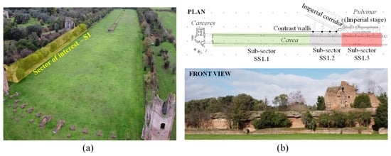
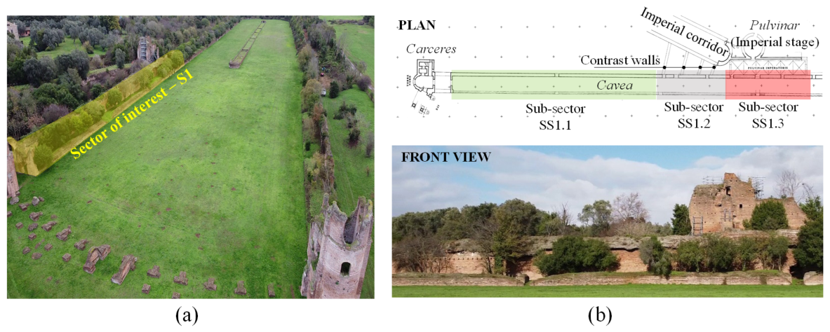
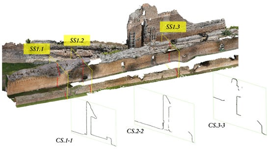
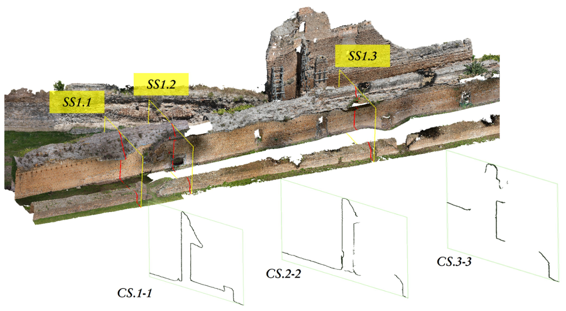
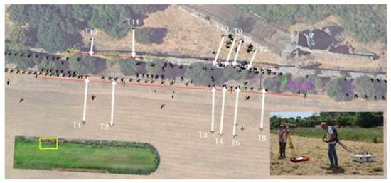
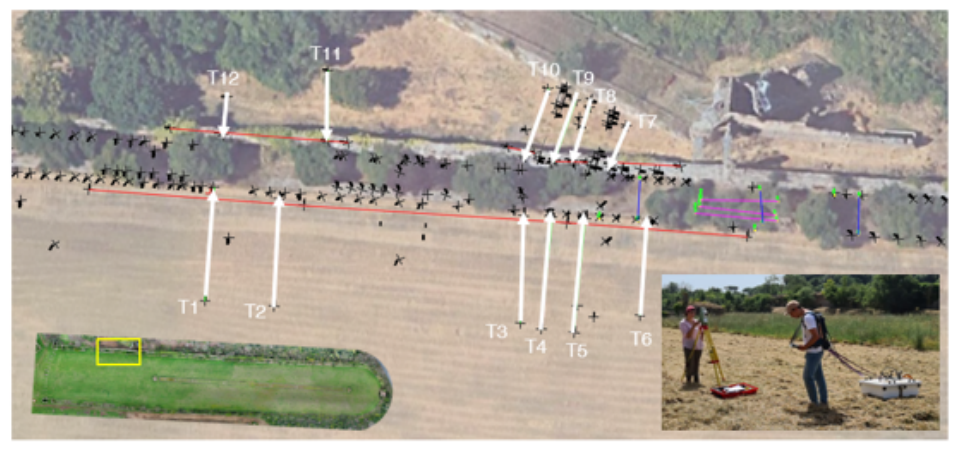
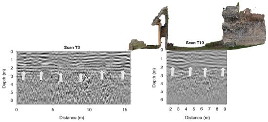
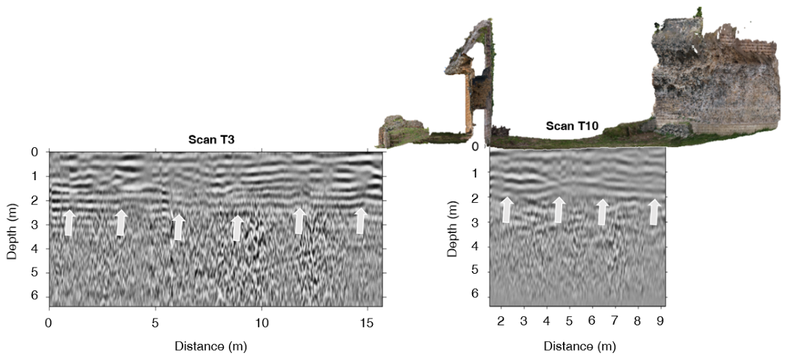
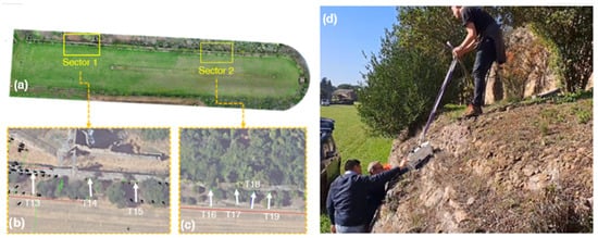
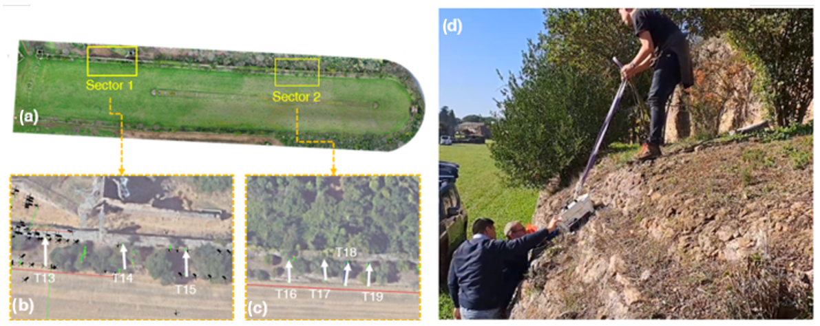
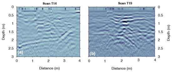
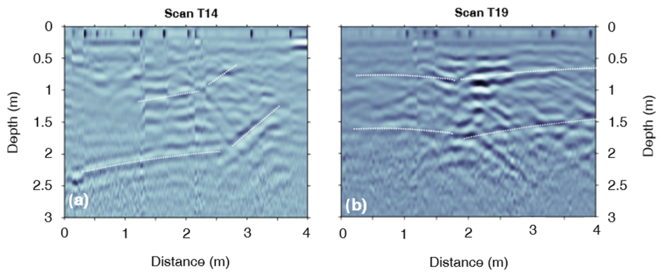
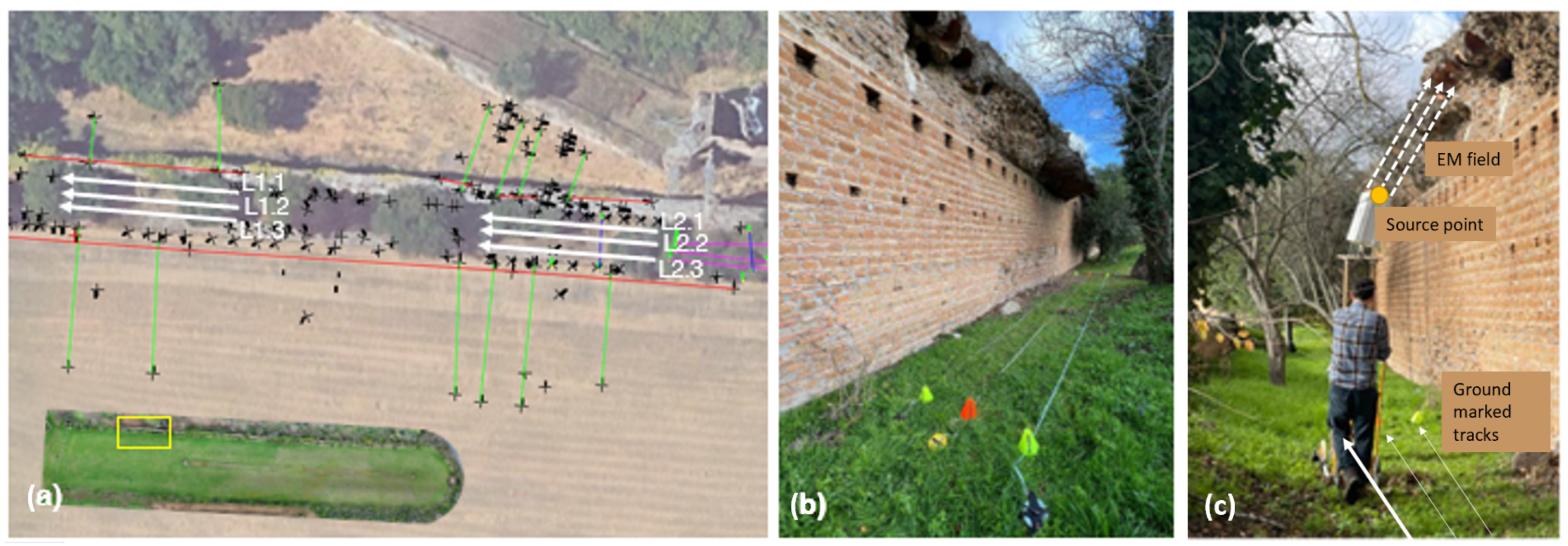
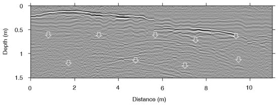
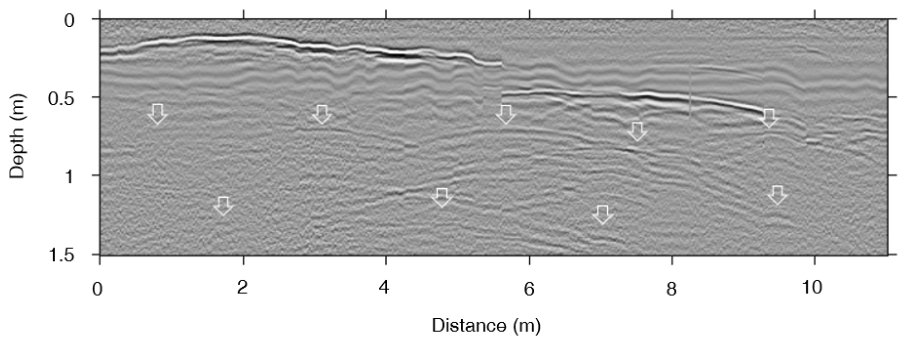
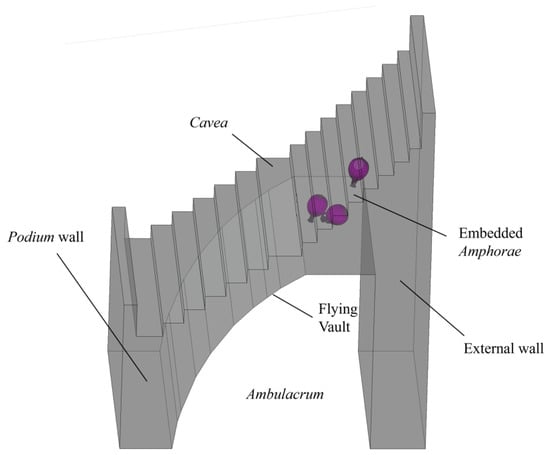
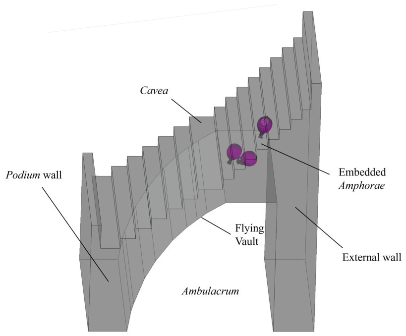
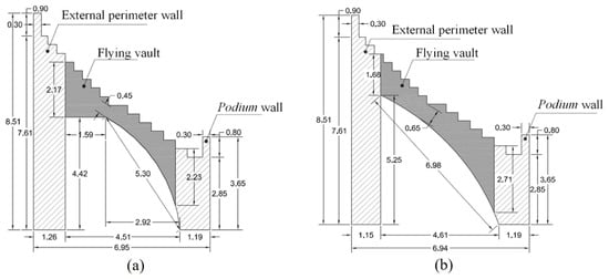
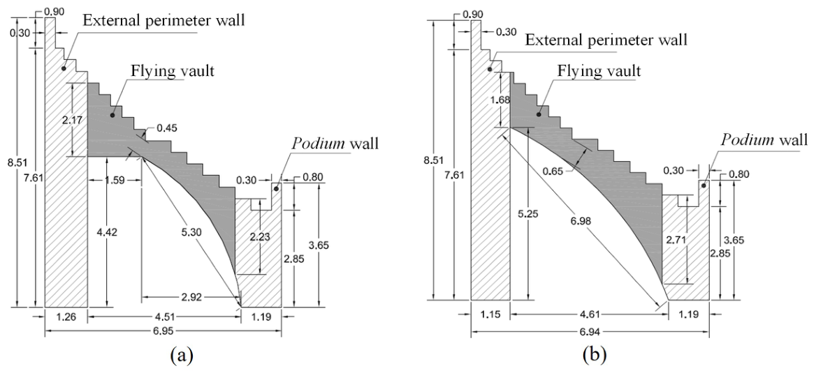
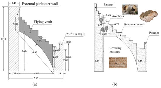
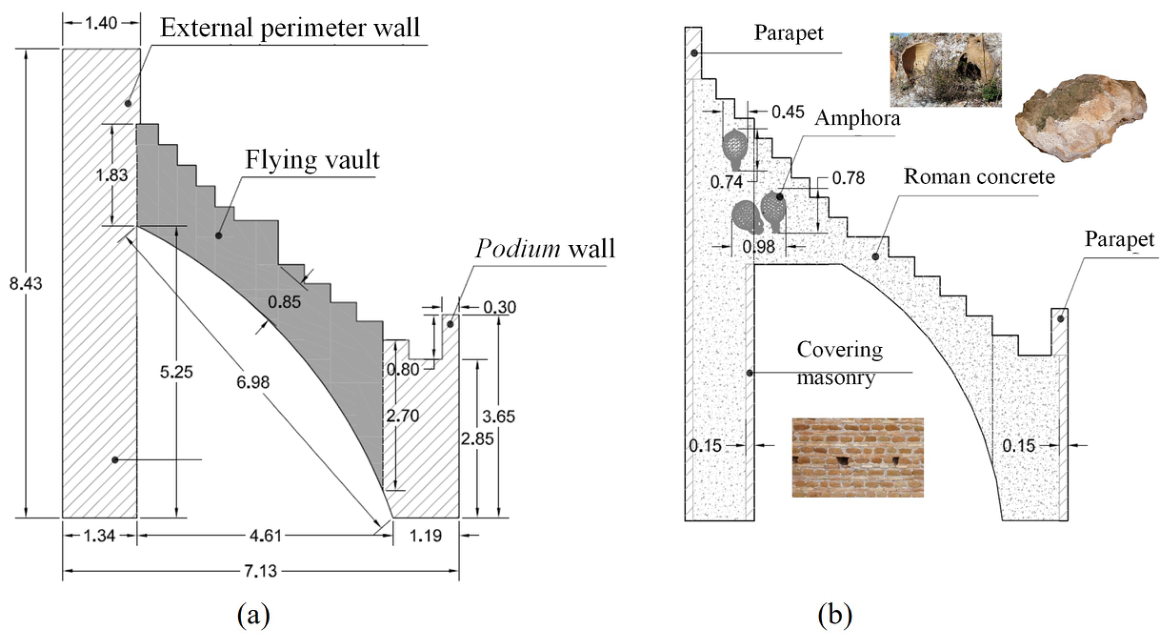
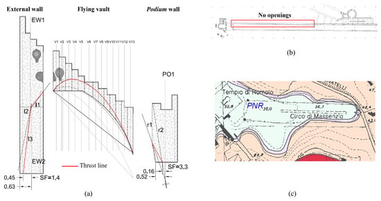
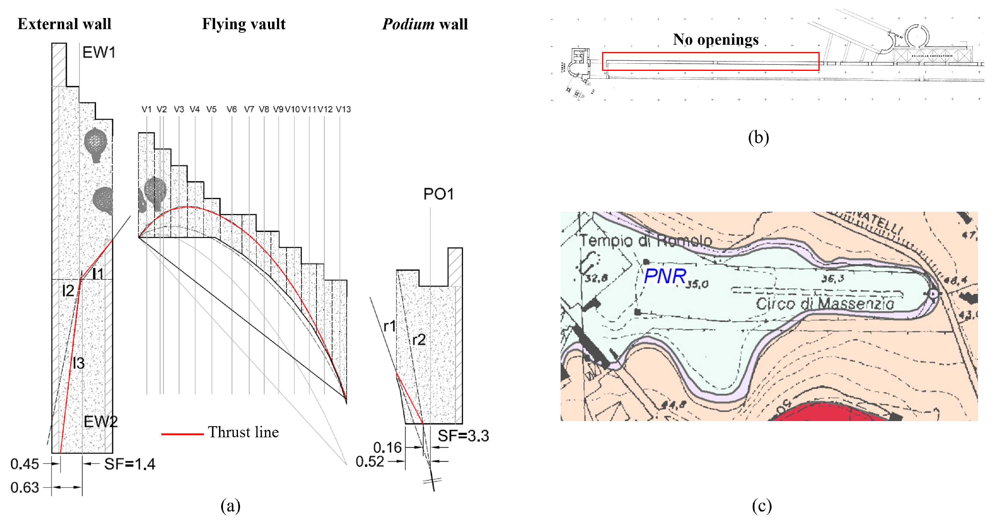
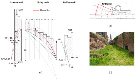
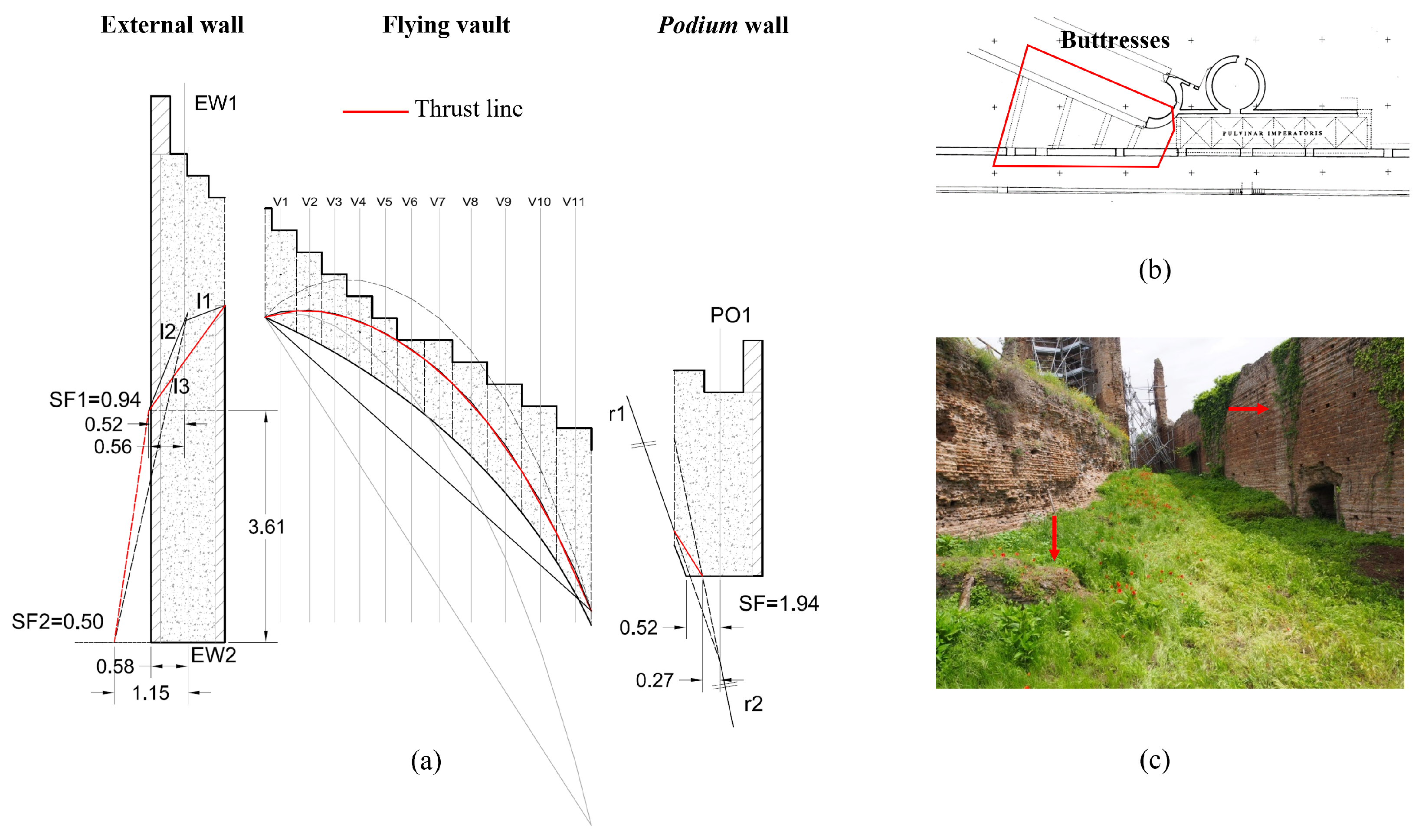
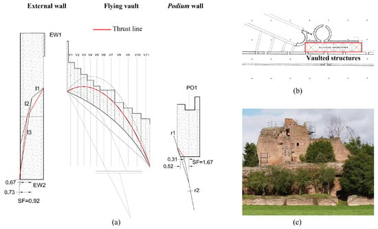
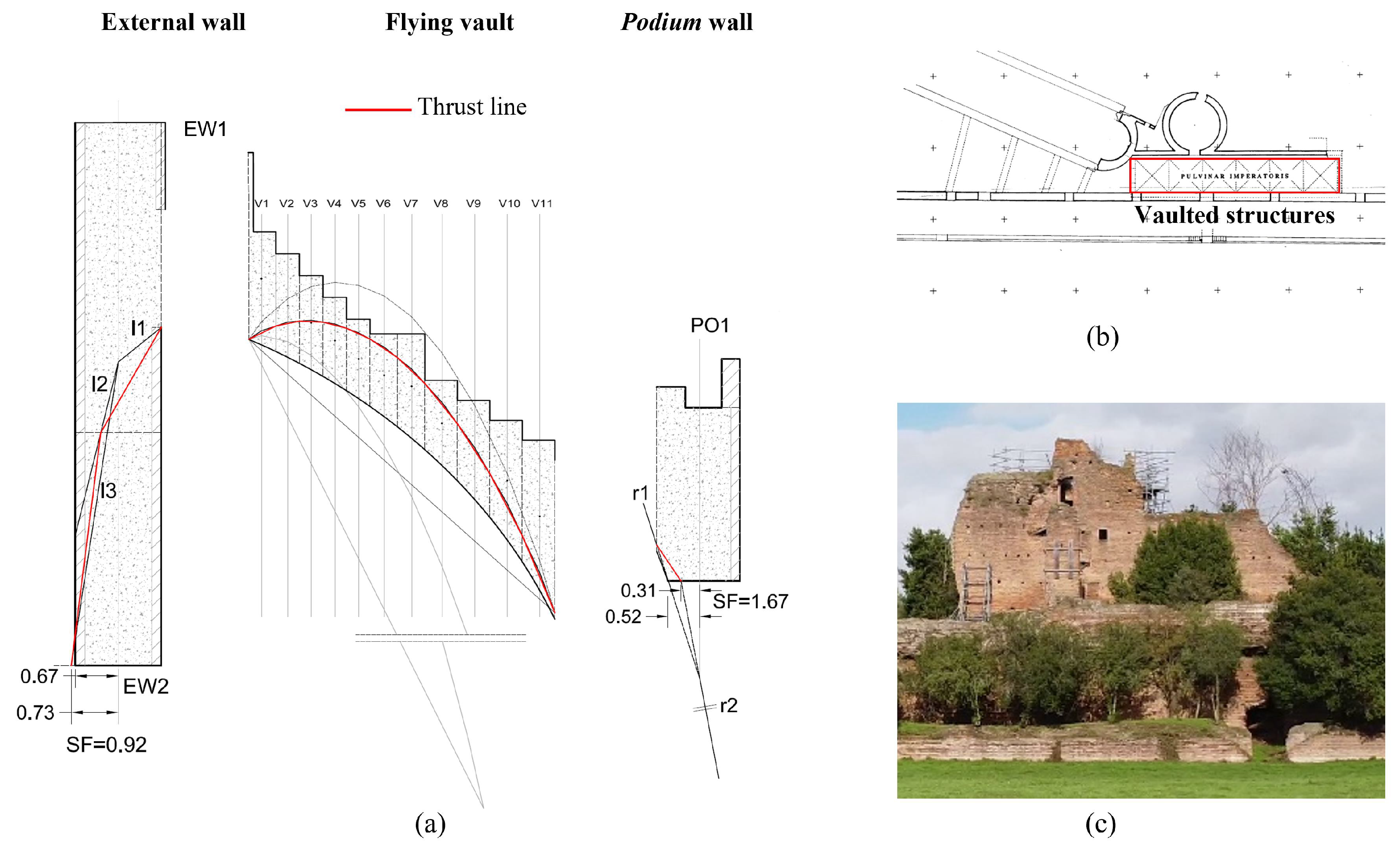

Disclaimer/Publisher’s Note: The statements, opinions and data contained in all publications are solely those of the individual author(s) and contributor(s) and not of MDPI and/or the editor(s). MDPI and/or the editor(s) disclaim responsibility for any injury to people or property resulting from any ideas, methods, instructions or products referred to in the content. |
© 2026 by the authors. Licensee MDPI, Basel, Switzerland. This article is an open access article distributed under the terms and conditions of the Creative Commons Attribution (CC BY) license.