


Abstract
The eastern African archaeological record is central to understanding early human evolution, yet its Pleistocene sites often present major challenges for public interpretation due to their open-air character and limited monumentality. In this context, in situ musealisation has emerged as a key strategy for combining conservation, research, and public access. This paper examines the historical development of such practices in eastern African archaeology through a comparative assessment of major sites, including Olorgesailie, Kariandusi, Isimila, and Olduvai Gorge, with particular emphasis on the Melka Kunture and Balchit (Ethiopia) archaeological complex. The analysis shows that early initiatives were largely experimental, frequently linked to specific academic events or tourism development, and commonly based on the direct exposure of archaeological surfaces, which generated important conservation and research constraints. By contrast, Melka Kunture represents a more integrated management model that combines landscape-scale interpretation, controlled visitor itineraries, multilingual outreach, high-resolution documentation, and the strategic use of replicas in a sensitive context. Recently inscribed on the UNESCO World Heritage List, the site illustrates how Pleistocene heritage can be made publicly accessible without compromising scientific integrity.
1. Introduction
Lower and Middle Pleistocene archaeological sites in Africa are fundamental to understanding the early stages of human evolution. Since the early 20th century, these contexts have yielded key evidence for the emergence of the genus Homo, the development of early lithic technologies, and long-term interactions between hominin groups and changing environments. However, despite its extraordinary scientific significance, many of these sites remain difficult to communicate to wider audiences. Unlike monumental historical remains, Pleistocene sites often consist of open-air deposits, stratified sediments, or cave sequences with limited visual impact, which complicates their integration into conventional heritage and tourism frameworks [1,2].
One response to this challenge has been the development of in situ musealisation strategies, where archaeological evidence is presented within or near its original depositional context. In eastern Africa, such initiatives emerged relatively early and represent some of the first global attempts to publicly interpret deep-time archaeological landscapes associated with human origins. Many of these early projects were experimental, often developed before the consolidation of heritage management standards and frequently linked to specific research programmes or tourism initiatives.
Although the number of publicly accessible Pleistocene sites has increased in recent decades across both Africa and Europe, where Italian projects such as Notarchirico, Isernia la Pineta, and La Polledrara are particularly prominent [1], the scholarly literature addressing their museography, conservation logic, and management models remains fragmented. Existing studies often focus on individual sites, technical interventions, or regional narratives, while broader comparative analyses remain limited [1,3]. Consequently, there is still an insufficient understanding of how different models of in situ presentation have evolved, the constraints they have faced, and which practices may offer sustainable solutions for the future.
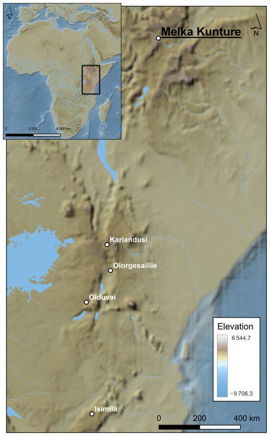
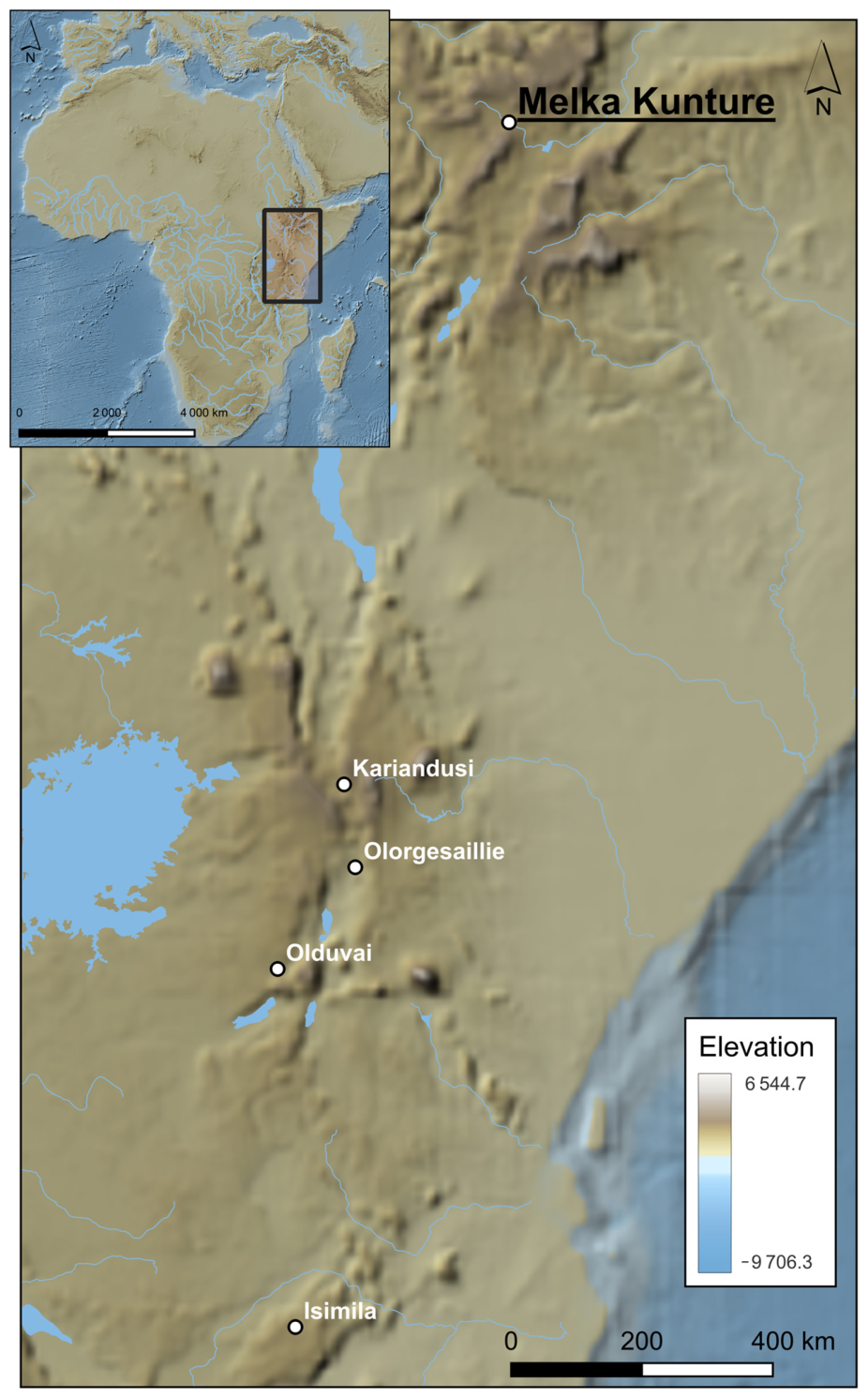
Within this framework, the MKB archaeological complex (Upper Awash, Ethiopia) serves as a significant case study (Figure 1). This cluster of sites provides an exceptional record of human cultural and biological evolution spanning approximately two million years, featuring a continuous sequence from the late Oldowan to the Middle and Late Stone Age [3,4]. The presence of some of the earliest evidence of the Acheulean techno-complex, alongside fossils of various Homo species, establishes MKB as a key record for human evolution in Eastern Africa [5]. The site’s scientific importance, combined with its ongoing development into an archaeological park and the musealisation of several areas, has recently led to its designation as a World Heritage site. This status confirms its role as a benchmark for both research and heritage management.
Figure 1.
Location map of the main sites cited in the text.
This paper analyses the principal musealised Pleistocene sites in Eastern Africa (Figure 1) from a comparative heritage perspective. It examines their management, conservation, and presentation models, arguing that MKB represents a more integrated phase in the evolution of in situ musealisation. More broadly, the study explores how early prehistoric sites can be made publicly accessible while preserving their scientific and material integrity.
2. Materials and Methods
The methodology combines a literature review, fieldwork observations, and archival research into various in situ solutions implemented at eastern African Pleistocene sites. The literature review focused primarily on Olorgesailie, Kariandusi, and Isimila, whereas field and archival analyses were conducted at Olduvai Gorge and, more extensively, at MKB.
The literature review drew on scientific publications, technical reports, and heritage management documentation. Additionally, it evaluated the museological proposals, conservation infrastructures, visitor itineraries, and management models established at these locations. For MKB, this was supplemented by archival research and direct involvement in the excavation, research, conservation, and museum development activities undertaken by the archaeological project. This fieldwork enabled the integration of primary observations on heritage management, in situ conservation, and the relationship between archaeological research and public outreach.
3. Eastern African Archaeological Sites with Musealisation Proposals
3.1. Olorgesailie
The Olorgesailie site is located in the southern sector of the Kenyan Rift Valley (1.5° S, 36.4° E), within a large sedimentary basin (~80 km2) approximately 90 km southwest of Nairobi [6]. The identification of Olorgesailie dates to 1919, when geologist J. W. Gregory identified lithic tools in the area. However, it was not until the 1940s that Louis and Mary Leakey undertook systematic archaeological surveys in this sector of the Rift Valley, leading to Mary Leakey’s discovery of the main site in 1942 [6]. Extensive excavations conducted between 1943 and 1945 revealed dense concentrations of lithic industry and broad occupation surfaces, which served as the foundation for the site’s subsequent musealisation [6]. From a contemporary perspective, it can be argued that this research established a new direction for prehistoric archaeology in Africa. The site’s presentation at the 1st Pan-African Congress on Prehistory (Nairobi, 1947) consolidated its status as an international benchmark. Subsequent research was conducted by Merrick Posnansky, although the primary research phase was led by Glynn Isaac between 1961 and 1965 [6]. Since 1985, investigations directed by Richard Potts have broadened the focus towards landscape analysis [7,8,9].
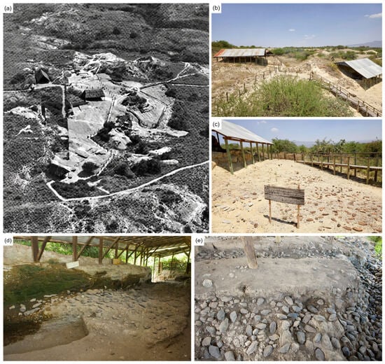
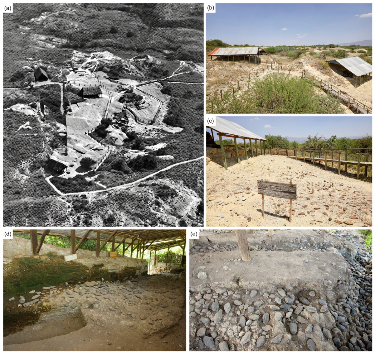
The Acheulean levels at Olorgesailie are distributed throughout the extensive stratigraphic sequence of the Olorgesailie Formation, spanning from approximately 1.0 to 0.5 Ma ago [9]. A defining feature of these levels is the recurrent presence of extensive accumulations of LCTs, particularly handaxes. Notable among these is Member 7, which contains sites with the densest concentrations of LCTs, such as site DE/89 [6]. This sector coincides with the area currently musealised within the Olorgesailie Prehistoric Site Museum, where the historical excavations of Leakey and Isaac left large accumulations of LCTs exposed in situ for public viewing (Figure 2a). These concentrations, formed in contexts of relatively rapid deposition, have allowed for exceptional preservation and constitute the core of the site’s museological narrative [10]. Hominin remains have also been documented, most notably a partial skull attributed to Homo erectus (KNM-OL 45,500), providing direct evidence of their presence at the site [10].
Figure 2.
General view of the Olorgesailie site museum in the 1970s (a) [6] and current views of the same areas (b,c). Preserved surface of the “Upper Site” at Kariandusi (d) and detail of the LCTs accumulations of the “Lower Site” (e).
Musealisation Proposal
Olorgesailie represents one of the earliest, most influential, and most paradigmatic examples of in situ archaeological musealisation in eastern Africa. From the moment of discovery, Louis and Mary Leakey made a fundamental decision: to preserve artifact concentrations in their original positions, eschewing total extraction in favour of direct exhibition. Following the 1942 discovery of vast LCT concentrations, the team deliberately chose to keep at least one of these areas intact. This commitment to the direct conservation of the archaeological context, at a time when extractive approaches predominated, is one of the site’s most innovative features. This choice gave rise to the concept of the “museum on the spot”, which would profoundly influence the subsequent development of archaeological museography in the region [6,11].
The formalisation of the site’s musealisation began in 1947, triggered by the 1st Pan-African Congress on Prehistory. The organisation of the congress necessitated the preparation of several sites for visits, with Olorgesailie serving as a primary enclave. This preparation involved cleaning and consolidating high-density artifact areas, organising visitor routes, and constructing basic infrastructure, culminating in the official inauguration of the site as an open-air museum. A key element was the negotiation with local Maasai communities, who ceded the land containing the main sites in exchange for benefits such as the construction of a water point for their livestock. This agreement allowed the area to be demarcated and fenced, ensuring its protection [6,9,11].
From a museographic perspective, the adopted model is characterised by minimal architectural intervention and the centrality of the archaeological record itself as the primary exhibit. Trenches containing in situ LCT concentrations and faunal remains (including hippo and elephant remains) were preserved and protected by lightweight wood and corrugated iron structures, allowing observation without disturbing the deposits (Figure 2b,c). The installation of an elevated wooden walkway (the “Catwalk”) provided essential infrastructure, allowing visitors to traverse the site without compromising its integrity. This approach, later known as the “Olorgesailie style” of excavation, would be implemented at other sites such as Kalambo Falls, Isimila, and Olduvai Gorge [6,9,11]. Much of this infrastructure was built by Italian prisoners of war under the direction of the Della Giustina brothers [6,11].
Today, Olorgesailie operates as a visitor site managed by the NMK, integrating educational and touristic functions. The complex features a site museum and visitor centre that offers an introductory exhibition on the geological context, human evolution, and key archaeological and faunal finds, including lithic tools and fossil casts. Signposted trails lead from this space to the musealised archaeological areas. Furthermore, the complex includes complementary infrastructure (picnic areas, campsites, and basic accommodation), facilitating its integration into broader Rift Valley tourist circuits alongside destinations such as Lake Magadi. The site is also promoted via the NMK’s digital platforms [9,11].
3.2. Kariandusi
Kariandusi is located in the eastern sector of the Gregory Rift Valley, approximately 120 km north-northwest of Nairobi and 2 km east of Lake Elmenteita (0.45° S, 36.28° E) [12,13,14]. While its chronology is not fully established, it is dated to approximately 0.8 Ma [15]. The site was discovered in 1929 by Dr J. D. Solomon and Miss E. Kitson during a Louis Leakey expedition to eastern Africa. Since then, it has acquired exceptional relevance as one of the first Acheulean sites documented in the region [12]. Initial excavations between 1929 and 1931 recovered an abundant collection of LCTs, mostly knapped on obsidian [16].
The site was re-excavated in 1946 as part of the preparations for the 1st Pan-African Congress on Prehistory, mirroring the process at Olorgesailie. Kariandusi was included in the congress itinerary, although it was somewhat overshadowed by the prominence of Olorgesailie and Olduvai [14]. During these interventions, a new trench was opened and subsequently musealised [11]. This decision involved maintaining the artefacts in their original positions to facilitate direct exhibition, although this limited the potential for detailed analysis [12], a concern subsequently noted at other sites such as Olorgesailie [14]. A third research phase took place between 1973 and 1974 under the direction of John Gowlett. During this campaign, several trenches (A, B, and C) were excavated, allowing for a distinction between the “Upper Site” and “Lower Site” and providing new stratigraphic, taphonomic, and technological data [15].
Although Kariandusi has often been considered a secondary context site, its LCT assemblages, particularly those knapped on obsidian, have enabled pioneering analyses of size variation, raw material procurement, and taphonomy [13,14,15]. Furthermore, its historical importance is indisputable: it was one of the first Lower Palaeolithic sites discovered in eastern Africa and one of Louis Leakey’s first major field sites [17].
Musealisation Proposal
Alongside Olorgesailie, Kariandusi represents one of the earliest instances of in situ musealisation of Pleistocene sites in eastern Africa, linked to the 1947 Pan-African Congress. Mary Leakey notes that a larger trench was specifically opened to facilitate visits by congress delegates [11]. This area eventually became a permanent open-air exhibition space that remains part of the museum circuit today (Figure 2d). Subsequently, the 1974 finds from the Lower Site were integrated into the museological discourse (Figure 2e). While the decision to maintain artefacts in situ imposed certain constraints on detailed study [12], it allowed for the preservation of a stratigraphic profile and an archaeological assemblage that is easily understood by the public.
The musealisation of Kariandusi should therefore be viewed as a progressive process: from the initial preservation of the 1946–1947 excavations to the integration of new archaeological sectors and the construction of interpretive infrastructure. In this context, excavated areas were protected by simple structures, such as timber enclosures with corrugated iron roofing, ensuring the conservation of archaeological deposits while allowing for public display. Furthermore, the first visitor guide for Kariandusi was produced by Dr Merrick Posnansky in the 1950s [14].
Today, the site operates as the Kariandusi Prehistoric Site, an open-air museum managed by the NMK. The complex includes various infrastructures that support its educational and exhibition roles, most notably an exhibition building opened in 2003 housing archaeological material, fossil casts, and dioramas. Other features include a large timber hut moved from Gilgil in 1974, used as a supplementary exhibition space, and the guides’ hut, one of the oldest buildings on the site. Access to the archaeological areas is provided via signposted trails, and the musealised sectors feature specific signage advising visitors not to touch the remains, thereby aiding conservation. However, the surrounding environment has undergone significant transformations due to the expansion of the diatomite industry, which has notably altered the landscape and modified the perception of the site compared to mid-20th-century descriptions [14,17].
3.3. Isimila
The Isimila archaeological site is located in the Iringa region of southern Tanzania (7.90° S, 35.47° E), at an altitude of approximately 1650 m above sea level. It is situated within an erosional gully system (locally known as a korongo) associated with the Isimila stream. The landscape is heavily defined by active geomorphological processes [18].
The history of research at Isimila dates back to the initial geological observations of D. R. Grantham in 1927, although the archaeological discovery itself is attributed to D. A. Maclennan in 1951, who collected the first lithic artefacts. Following this find, F. C. Howell conducted an initial survey in 1954 and organised the first excavation campaigns between 1957 and 1958. This work was carried out by a team from the University of Chicago in collaboration with the Government of the Territory of Tanganyika, involving G. H. Cole and M. R. Kleindienst. These investigations established the stratigraphic sequence and confirmed the site’s significance within the African Acheulean [19,20,21]. Subsequently, the site was the focus of further campaigns, such as those by Keller and Hansen in 1969–1970, as well as more recent research by international and Tanzanian teams. These later studies have employed modern methodologies, including optically stimulated luminescence (OSL) dating and drone-based documentation to monitor erosion and topographical changes [18,19,21,22,23].
Isimila is characterised by a high density of Acheulean lithic assemblages and Pleistocene faunal remains (including Elephas recki, Hippopotamus amphibius, and Diceros bicornis). The site features several stratigraphic horizons (Sands 1–5) documenting repeated occupations, likely associated with an ancient lacustrine system. Although currently under revision, available dates place some levels at approximately 260,000 ± 70,000 years ago [24], while more recent interpretations suggest the sequence may span between 300,000 and 500,000 years, or even date back to the early Middle Pleistocene, showing parallels with Olduvai [18,19]. Furthermore, the site contains evidence of the Middle Stone Age and Late Stone Age, indicating recurrent human presence over time [20].
Musealisation Proposal
In 1958, Isimila was granted protected status and began to be developed as an exhibition model based on the in situ preservation of the archaeological record. Several areas excavated in 1957 were preserved in their original context, including the K18 trenches, the K6 gravel bed, and a hippo skeleton located in square H20 (Figure 3e). Structurally, four exhibition areas were established: two were protected by semi-enclosed roofed structures to preserve faunal and archaeological remains (currently only archaeological ones) alongside visible stratigraphic profiles, while two open areas were demarcated with wire mesh to display the surface density of artefacts [19,25].
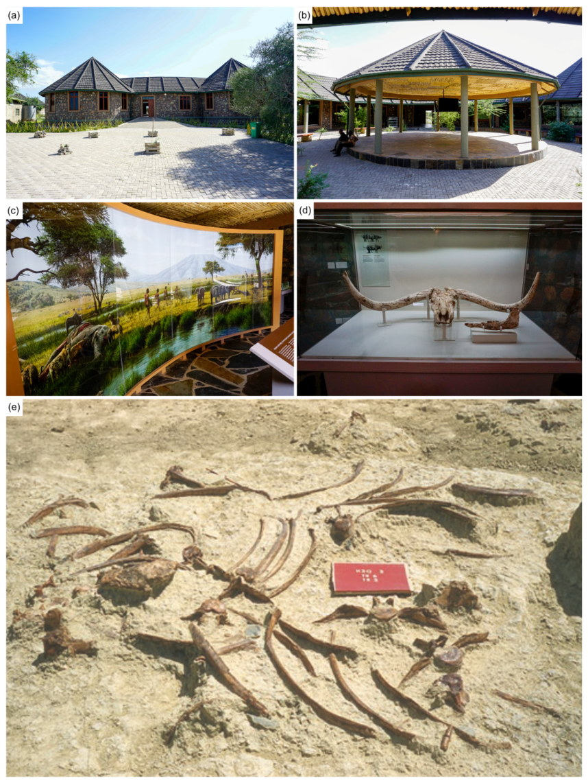
Figure 3.
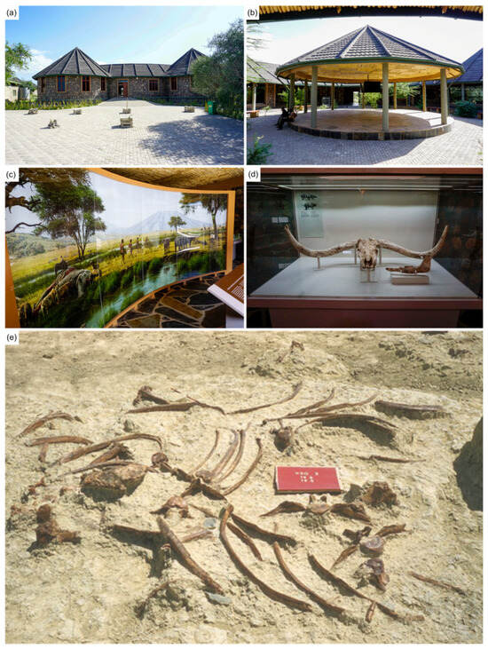
Exterior (a) and interior (b) views of the Olduvai Gorge Museum, including details of the exhibition design (c,d). Hippopotamus skeleton identified in square H20 at Isimila (e) (no longer extant) [21].
This approach sought to make the archaeological evidence visible without decontextualising it, aligning with the eastern African experiences at Olorgesailie and Kariandusi. However, the fragility of this model soon became apparent at Isimila. One of the most iconic musealised surfaces, the hippo skeleton protected under a structure, was virtually destroyed by 1963 due to erosion and deteriorating conservation conditions [19]. According to Tillya [25], the protective structures continued to decline in subsequent decades. By 1992, the walls of the shelter covering the hippo skeleton were heavily eroded and finally collapsed in 1994, but it was rebuilt a year later for a different purpose. Despite these setbacks, the museological system has been maintained and adapted through reconstructions and new structural solutions. Musealisation was further supported by basic infrastructure, including a custodian/guide office, access trails, and site boundaries [25].
The site, known as the Isimila Stone Age Site and Natural Pillars, has been an NMT since 1964 and is protected under current heritage legislation. The DAT is responsible for its maintenance. The site provides basic visitor facilities, including a reception centre with explanatory panels and historical, ethnographic, and colonial-period material, as well as interpretive signage, parking, and local guide services. The itinerary combines the archaeological record with prominent landscape features, such as the valley’s characteristic eroded pillars. The site is integrated into the Iringa region’s tourist circuits, connecting with locations like Ruaha National Park and other regional cultural and natural routes. Nevertheless, Isimila continues to face significant challenges related to natural erosion, anthropogenic pressure, and the need for improved long-term conservation and participatory management models [26].
3.4. Olduvai Gorge
Olduvai Gorge is situated within the NCAA in the eastern Serengeti (3.00° S, 35.35° E) and, like the aforementioned sites, is geologically linked to the Rift Valley. The site is structured around a main gorge, approximately 46 km long, and a 16 km side branch, both incised into a lacustrine, fluvial, and volcanic sedimentary sequence exceeding 100 m in thickness [27,28]. This sequence preserves a nearly continuous record of approximately two million years of cultural and biological evolution, establishing Olduvai as one of the world’s most comprehensive palaeoanthropological contexts [29].
The history of research at Olduvai is divided into several well-defined phases. Its origins date back to 1911, when the German entomologist Wilhelm Kattwinkel discovered the first fossil remains in the gorge. This find led to the first palaeontological expedition in 1913, directed by Hans Reck, who established the initial stratigraphic sequence and the division of the primary sedimentary beds. This framework was later refined by Richard Hay, whose precise characterisation of the units consolidated the classic division into Beds I–IV and their associated members [27,28,29].
Systematic archaeological research began in the 1930s with Louis Leakey, who organised several campaigns between 1931 and 1935, identifying the first sites and stone tool assemblages [30]. Research intensified from the 1950s onwards, particularly under the direction of Mary Leakey, marking a fundamental phase that lasted until the 1980s [28,30,31,32,33]. During this period, numerous sites were excavated across the stratigraphic sequence, defining the primary Oldowan assemblages and identifying key localities such as DK, FLK Zinj, and MNK. These findings, frequently published in Nature, positioned eastern Africa at the centre of the global debate on human origins. Mid-20th-century discoveries proved to be a turning point: in 1959, the discovery of the Paranthropus boisei skull (Zinjanthropus), dated to approximately 1.75 Ma, revolutionised the chronology of human evolution [33]. Shortly thereafter, the discovery of Homo habilis reinforced Olduvai’s role as a primary stage for human evolution [32].
From the 1980s, research entered a new phase characterised by institutional diversification, international collaboration, and interdisciplinary methodologies. Following the era dominated by the Leakeys, various groups expanded the traditional focus from isolated site excavations to broader landscape contexts. Notable milestones include the 1986 discovery of the OH 62 partial skeleton (Homo habilis), which informed debates on early Homo variability [34]. In the late 1980s, the Olduvai Landscape Paleoanthropology Project (OLAPP), directed by Robert Blumenschine and Fidelis Masao, introduced a landscape-based archaeological approach [35]. In the 21st century, research has continued to broaden through projects such as The Olduvai Paleoanthropology and Paleoecology Project (TOPPP), led by Manuel Domínguez-Rodrigo, Enrique Baquedano, and Audax Mabulla. This project has consolidated an interdisciplinary perspective by integrating taphonomic, technological, and palaeoecological studies [29]. Concurrently, other programmes like the Olduvai Geochronology and Archaeology Project (OGAP) and the Olduvai Gorge Coring Project (OGCP) have deepened our understanding of chronology, cultural evolution, and long-term environmental change [36,37]. Furthermore, discoveries such as the hominin footprints at the nearby site of Laetoli [38] extend the region’s importance beyond the gorge itself.
Musealisation Proposal
The musealisation of Olduvai presents a unique model compared to the previously analysed cases, as it is deeply intertwined with the progression of scientific research. Unlike Olorgesailie, where musealisation was planned early, the process at Olduvai developed gradually through the interaction between scientific inquiry and growing tourism. Following the international dissemination of findings in the 1960s, the site was rapidly integrated into tourist circuits as a natural stop between the Serengeti and Ngorongoro. This necessitated the creation of specific infrastructure for visits and interpretation [11]. Key developments included guided tours of major sites, such as FLK Zinj, and the establishment of “open-air museums” directly on the excavated surfaces, primarily at JK and DK. However, these early proposals have since undergone significant transformation: the musealised area at JK has disappeared, while the exposed surface at DK is considerably disturbed. In addition to these exposed areas, a small site museum was established to offer a general interpretation of the gorge’s geology, accompanied by fossil casts and lithic tools. This space was complemented by thatched-roof structures for rest and landscape observation, alongside educational materials and specialised guides [11].
Simultaneously, Mary Leakey’s camp evolved into a semi-permanent research base, featuring work areas, laboratories, storage for excavated materials, and visitor accommodation. This development reflects the progressive institutionalisation of the site as both a scientific hub and an educational destination. For visitors, the ongoing or recent archaeological work became part of the interpretive narrative itself [11]. Over time, this was reinforced by incorporating the camp (The Mary Leakey Living Museum) into the official tour. Moreover, the site’s international fame has contributed to a narrative that, in some respects, has romanticised both the location and the figures of its researchers.
In later phases, particularly since the late 20th and early 21st centuries, this model has been consolidated through a more complex museum infrastructure. The original museum, built in the 1970s by Mary Leakey, was expanded in the 1990s by the Getty Conservation Institute and more recently replaced or supplemented by a new facility inaugurated between 2017 and 2018 (Figure 3a,b). Its circular design is inspired by traditional Maasai dwellings [39]. The current museum recently opened a permanent exhibition based on “The Cradle of Mankind” project, curated by Manuel Domínguez-Rodrigo and Enrique Baquedano. Developed in collaboration with several international institutions, this project began as a travelling exhibition in 2014 at the Regional Archaeological and Palaeontological Museum of Madrid (Spain). After touring various museums, it served as the basis for the permanent displays at both the National Museum in Dar es Salaam (2018) and the new Olduvai Gorge Museum, the latter inaugurated with European Union support [39]. These exhibitions combine original fossils, casts, and scientific illustrations (Figure 3c,d). They are further complemented by the 2009 signage of the FLK Zinj site, marking the 50th anniversary of the discovery of Paranthropus boisei [39].
Today, Olduvai is a centre for both research and tourism, managed by the DAT within the NCAA.
4. Melka Kunture and Balchit: Research History and Archaeological Record
4.1. History of Investigation
Melka Kunture and Balchit (8.70° N, 38.59° E and 2000–2200 m above sea level) were discovered in 1963 when Dutch hydrogeologist Gerard Dekker identified significant concentrations of stone tools along the banks of the Awash River [4,40]. Between November 1963 and January 1964, the French prehistorian Gérard Bailloud conducted an initial survey, documenting abundant lithic evidence spanning all stages of the African Stone Age [41]. Recognising the area’s potential, Bailloud recommended that his colleague, Jean Chavaillon, initiate contact with the Ethiopian authorities to establish a formal research programme.
In 1965, Chavaillon arrived in Ethiopia, and the Mission archéologique française à Melka Kunture began annual excavation campaigns. These continued uninterrupted until the 1980s, when fieldwork was suspended under the Derg regime. Research resumed sporadically in 1993, and in 1999 Chavaillon transferred the project’s leadership to Italian archaeologist Marcello Piperno, a long-term collaborator.
Under the new title of Missione archeologica italiana a Melka Kunture e Balchit, Piperno prioritised the systematisation and publication of over three decades of research, focusing primarily on Oldowan and Acheulean sites. This effort culminated in the publication of a comprehensive synthetic monograph [42]. Throughout this evolution, the EHA has played a fundamental role, providing institutional support, technical personnel, logistical resources, and the formal validation of research programmes. In 2010, the leadership passed to Margherita Mussi, who established the foundations of the current research at the site. Since 2019, the project has operated as an international collaboration: the Italo-Spanish Archaeological Mission at Melka Kunture and Balchit, co-directed by Margherita Mussi and Eduardo Méndez-Quintas.
4.2. The Archaeological Record of Melka Kunture and Balchit
MKB is not a single site but rather a cluster of localities that record human cultural and biological evolution over the last two million years [3,43]. These sites are contained within fluvio-lacustrine deposits of the palaeo-Awash and tributaries, interspersed with volcanic tuffs that attest to intense regional volcanic activity throughout much of the Pleistocene [44,45].
To date, approximately 1300 m2 has been excavated across 21 different sites, corresponding to 67 archaeological levels. Sites containing the Acheulean techno-complex, dated between 1.95 and 0.6 Ma, are particularly well-represented, constituting one of the longest and most complete sequences in the global archaeological record [5,6,7,8,9,10,11,12,13,14,15,16,17,18,19,20,21,22,23,24,25,26,27,28,29,30,31,32,33,34,35,36,37,38,39,40,41,42,43,44,45,46,47,48,49,50]. The primary research areas are located within the Gombore and Garba gullies, featuring sites such as Gombore I, Gombore II-1, Gombore II-2, Garba IV, Garba III, and Garba I, with a record spanning from 2.0 to 0.3 Ma [4,49,50,51,52]. Beyond this core area, currently designated as an archaeological reserve, other significant enclaves include the Simbiro, Wofi-Atebella, and Kella valleys, and the Balchit area. Recently, research has focused on the Simbiro Valley, specifically the “Monumental Section”, which is dated to over 1.3 Ma [48,53] while a cave with Late Stone Age (Beefa Cave) is now under research in the deep gully eroded downstream by the Awash [54].
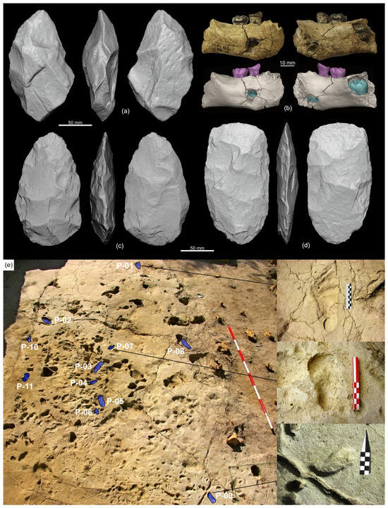
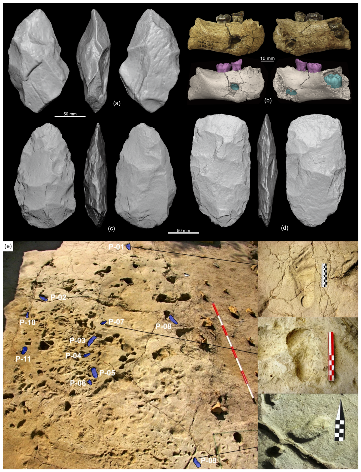
The cultural sequence at MKB covers almost the entire range of the African Stone Age. Garba IV (levels E and F) and Gombore I (levels C and D) contain the oldest levels, representing the terminal Oldowan at approximately 2.0 Ma [5,55]. Significantly, the immediate appearance of Acheulean technology in Garba IV (level D) and Gombore I (level B) represents the earliest known evidence of this techno-complex globally [5,56] (Figure 4a). Following this early emergence, the region shows a continuous human presence from 1.4 to 0.5 Ma across multiple sites in the Garba, Gombore, Simbiro, and Wofi-Atebella sectors [47,48,50,53,57] (Figure 4c,d). The transition to the Middle Stone Age (MSA) is less precisely dated but appears fully established around 0.2 Ma [51]. This was succeeded by the Late Stone Age (LSA), exemplified by the record at Beefa Cave [54].
Figure 4.
Stone tools and fossil remains from the MKB sites: handaxes and cleavers from Garba IVD ((a); 1.95 Ma), Atebella II ((c); 1.2 Ma), Garba I ((d); 0.6 Ma) and early Homo erectus mandible from Garba IVE ((b); 2.0 Ma). Palaeosurface at Gombore II-2 ((e); 0.7 Ma) showing various fossil tracks, including human footprints (highlighted in blue).
Environmental conditions throughout these occupations were influenced by local and global climatic variability, as part of the Dry evergreen Afromontane Forest and grassland complex (DAF). The DAF vegetation is quite distinct from the savanna environments of the eastern African sites at lower elevations. Large mammal assemblages show some level of endemism, with a notable abundance of hippopotamus, while other typical African savanna taxa, such as elephants, rhinoceros and giraffes are almost absent [58].
4.3. Human Fossil and Ichnological Record
In addition to the archaeological evidence, MKB has yielded hominin remains and fossil footprints within well-defined archaeological contexts. This is unusual in eastern Africa, where fossils are more commonly identified as surface finds. The direct association between hominin remains, footprints, and lithic tools provides critical data for understanding early human evolution, including the composition of hominin groups (documented via footprints of individuals of varying ages) and their adaptation to high-altitude environments, characterised by colder, wetter conditions, as opposed to the typical lowland savanna. The fossil record at MKB includes Homo erectus, Homo heidelbergensis/bodoensis, and archaic Homo sapiens. Some of the world’s earliest evidence of Homo erectus occurs at Garba IV (Level E) and Gombore I (Level B), dated to approximately 2.0–1.95 Ma [5,59,60] (Figure 4b). Cranial remains close to H. heidelbergensis/bodoensis were recovered at Gombore II, currently dated to around 1.0 Ma [61], while Garba III yielded remains of an early form of Homo sapiens [51].
Human footprints are primarily associated with Gombore II, specifically the Gombore II-Open Air Museum sequence and the Gombore II-2 sites, dating between 1.2 and 0.7 Ma [62,63] (Figure 4e).
5. The Open-Air Museum Project at Melka Kunture and Balchit
5.1. Project Antecedents
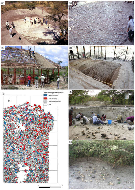
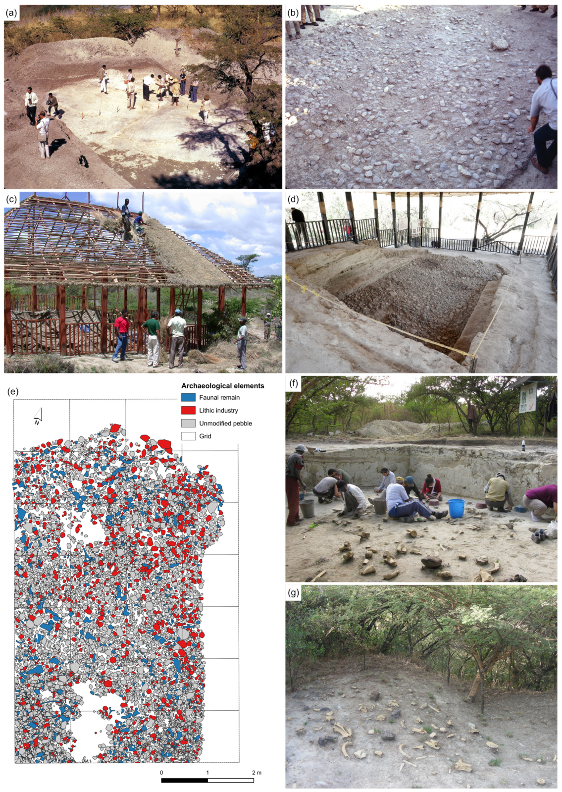
The musealisation of MKB emerged relatively late compared to other major African sites and is closely linked to the work of the Italian Archaeological Mission, directed by Marcello Piperno since 1999. Although Jean Chavaillon had proposed transforming the site into an open-air museum as early as the 1970s, the project only began to really materialise at the turn of the 21st century. Following the approach of Louis and Mary Leakey at Olorgesailie, Chavaillon had prepared a large excavated surface at the Acheulean site of Garba I (approximately 40 m2) for the 7th Pan-African Congress held in Addis Ababa in 1971 (Figure 5a,b). Sediments covering the archaeological level were temporarily removed to allow delegates to observe the occupation floor directly. The area was subsequently re-covered, with plans for its future display under a protective shelter as part of an open-air museum project [64,65,66].
Figure 5.
General view and detail of the extensive LCT accumulation at Garba I in 1971 (a,b). (a) Participants of the 7th Panafrican Congress of Prehistory and Quaternary Studies in 1971 visiting the area originally intended by Jean Chavaillon as preserved for exposure (picture courtesy of David Lubell). Gombore II Open-Air Museum: construction of the protective shelter (c), current appearance (d), and detailed site plan of the surface (e). Gombore II-2 during excavation from 2012 onwards (f) and detail of the bone casts (g).
However, this proposal was not fully realised until the arrival of the Italian mission, which reformulated the initial plans in collaboration with Ethiopian and Oromia regional authorities [4]. Starting in 1999, a structured programme was defined to create an archaeological park integrating research, conservation, and public outreach. Piperno’s proposal explicitly acknowledged Chavaillon’s influence but also drew heavily from Italian precedents in Pleistocene site management. Projects at sites such as Notarchirico (also led by Piperno [67]), Isernia La Pineta, and Casal de’ Pazzi had pioneered in situ conservation strategies in the 1980s and 90s. These involved protecting archaeological surfaces with permanent shelters and creating didactic circuits that allowed visitors to grasp the spatial organisation of prehistoric activities [1]. Local arboreal species were also reintroduced to restore the native vegetation which had almost disappeared due to agricultural activity.
5.2. Musealised Sites: The Butchery Site and the Open-Air Museum
The effective development of the open-air museum was consolidated in 2001 with the designation of a one-hectare area for permanent exhibition. This marked a qualitative shift from ad hoc interventions to global planning. Within this framework, the “Butchery Site” at Gombore II (now Gombore II-2, dated 0.75 Ma) was integrated into the visitor circuit using high-quality replicas (Figure 5f,g). Over 250 reproductions of palaeontological remains and lithic artefacts were produced through collaboration between Italian specialists and technicians from the National Museum in Addis Ababa [4]. This allowed for the presentation of a complex archaeological context without compromising the original remains. Alongside these developments, approximately twenty interpretation panels were installed in both English and Amharic. These provide detailed information regarding the site’s stratigraphy, prehistory, fauna, and hominin remains [4].
In 2002, the project advanced with the excavation and preparation of an Acheulean palaeosurface (~40 m2) at Gombore II, dated to ~1.0 Ma (Figure 5c–e). This site features a significant concentration of faunal remains, predominantly hippopotamus and bovids, alongside a major lithic assemblage including handaxes and cleavers [68]. Conservation measures included the consolidation of fragile obsidian artefacts and the construction of a large shelter using traditional techniques and materials, ensuring environmental protection while maintaining landscape harmony [4,68]. By 2003, a high-resolution map of over 6000 objects was completed for the Gombore II-Open Air Museum. Adhering to in situ principles, the materials were not removed; instead, research was conducted through direct surface observation and measurement [4,68,69].
5.3. The Site Museum
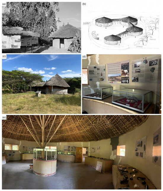
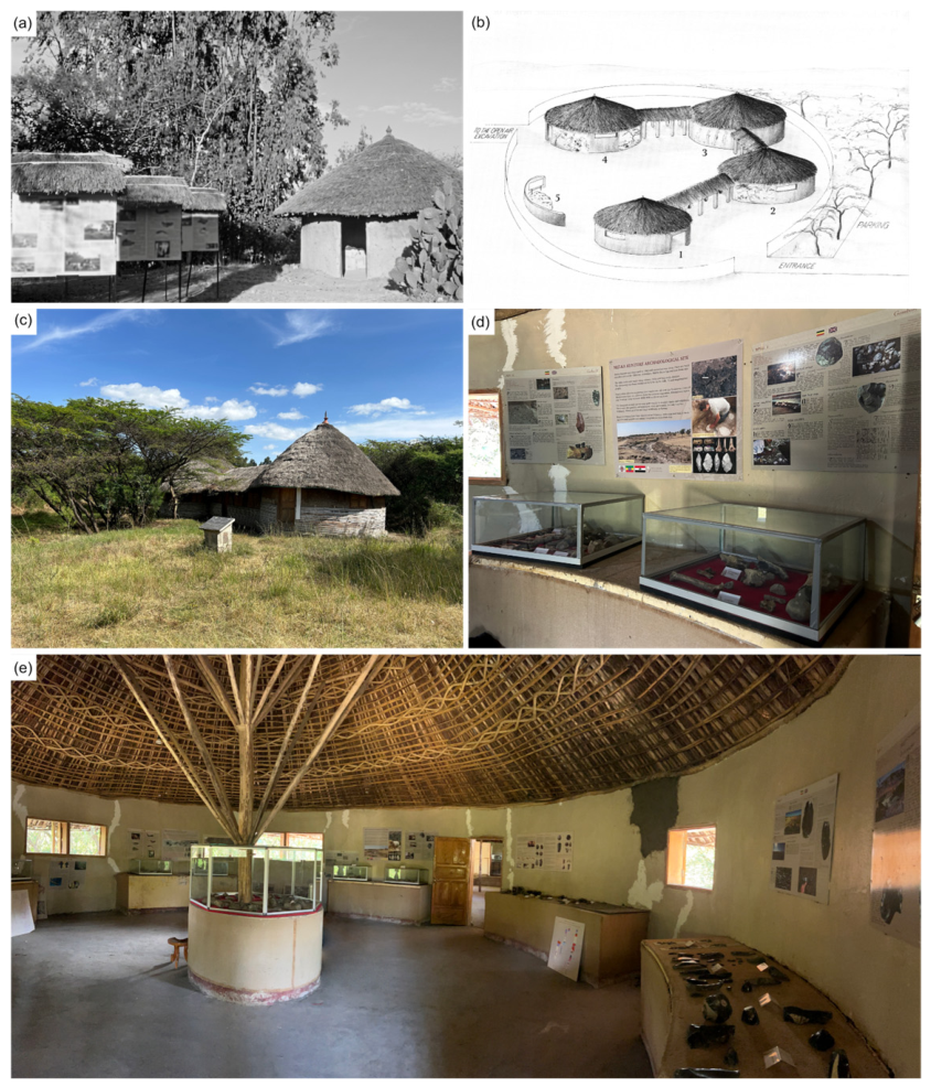
Parallel to the field of musealisation, the archaeological camp (originally established by Chavaillon) was upgraded to strengthen its exhibition role. In 2000, access was reorganised and the museum building was rehabilitated to house a new exhibition with panels in English, Amharic, and Oromo (Figure 6a). Panels were also added along the circuit including the nearby Gombore II-Open Air Museum and Butchery Site.
Figure 6.
The original MKB museum in 2000 (a); the 2003 museum design project (b); and its current exterior view (c). Details of the interior and exhibition design (d,e).
The process culminated after 2003 with the significant expansion of the protected area, supported by the European Union-funded project: “From the Past to the Present in Ethiopian Prehistory”. The design, illustrated by M. Pennacchioni, featured a circular layout composed of four traditional-style buildings (tukuls) (Figure 6b). These thematic pavilions were intended to be connected by a roofed corridor to create a continuous narrative flow. Although the initial design saw modifications, such as the connection corridors only being completed in 2018 with World Bank funding (Figure 6c), the museum successfully integrated the landscape, including a specific area dedicated to the Balchit obsidian outcrops. Furthermore, a new and much larger facility designed to house the museum was constructed that same year. Located beyond the site’s perimeter near the town of Melka Awash, the building currently remains unutilised.
Interpretive Narrative
The MKB site museum is structured around the prehistory of Africa and Ethiopia, human evolution, and the site’s primary localities. The exhibition narrative integrates original artefacts, replicas, and educational resources across four tukul (traditional Ethiopian buildings). The first, dedicated to “African Prehistory”, provides an overview of eastern African sites and the pioneering researchers. The second, “Geology and Volcanology”, explores the formation of the Ethiopian Rift, volcanic activity, and the raw materials utilised in lithic production. The third, “Palaeoanthropology”, traces human evolution, with particular emphasis on the Lucy or Laetoli finds.
Finally, the “Archaeology of Melka Kunture” section showcases original remains and casts of the site’s main stone tools, palaeoanthropological, and faunal remains. This collection includes an extensive Acheulean lithic assemblage, comprising handaxes, cleavers, and other types of stone tools from localities such as Garba IV, Gombore I, Simbiro III, Gombore II-1, and Garba I. It also features more recent obsidian tools from Balchit, illustrating the technological way of early hominins. These materials are complemented by faunal remains, primarily hippopotamus, bovid, and equid fossils, which contextualise hominin activities within their ecological environment (Figure 6d,e).
The museography utilizes mural panels and original artefacts on fixed pedestals. Following its formal inauguration in 2007 [66], the site was further enhanced with basic infrastructure (water, electricity, and roads) and a digital presence through a virtual museum project initiated by Piperno [70].
Today, MKB, which is protected by both national laws of the Federal Republic of Ethiopia and by laws of the Oromia Regional State, stands as a unique heritage complex in Ethiopia, integrating scientific research with education and tourism. It receives approximately 3000 visitors annually and serves as a vital socio-economic driver for the local community. The project’s maturity was officially recognised in 2024, when it was inscribed on the UNESCO World Heritage List during the 46th session of the Committee in New Delhi (https://whc.unesco.org/en/list/13 accessed on 15 April 2026).
5.4. Local Community Involvement
The local community has played a fundamental and continuous role in both archaeological research and the management and protection of the MKB site and its associated museum. Since the 1960s, the archaeological mission has regularly employed local residents for excavations, camp maintenance, security, transport, and other logistical tasks. Over time, many of these workers acquired specialised archaeological skills, eventually playing a key role in training new local staff and advancing excavation fieldwork [66]. Furthermore, the local population has actively contributed to identifying and protecting archaeological record by reporting new finds and helping safeguard the heritage against threats such as looting or illegal quarrying.
Their involvement proved pivotal during the process of inscribing MKB onto the UNESCO World Heritage List. During the preparation of the nomination file, a formal consultation process obtained the local community’s explicit consent, a support that has remained steadfast over time. This participation is essential not only to ensure conflict-free management but also to guarantee the daily protection of the site against external threats and pressures stemming from urban growth and extractive activities.
Currently, the local community actively participates in site dissemination and valorisation through the museum. Daily site management is structured around a site manager responsible for day-to-day administration and a specialised cultural heritage guide. Both positions depend on the local Awash-Melka Culture and Tourism Woreda Office and, subsequently, the Oromia Culture and Tourism Bureau.
6. Discussion
Since the mid-20th century, the in situ musealisation of Pleistocene sites in Eastern Africa has emerged as an innovative response to the need for preserving and providing access to the archaeological record within its original context. The cases of Olorgesailie, Kariandusi, Isimila, and Olduvai Gorge were pioneering in global terms; they attempted to make non-monumental archaeological evidence visible within its landscape context at a time when formal heritage-management frameworks were still poorly developed. These projects established an important principle: prehistoric sites associated with early human evolution could become public heritage spaces rather than remaining exclusively scientific localities (Table 1).
Table 1.
Summary table comparing the different sites recorded in the text, based on the main criteria analysed.
However, these first-generation models were frequently made by immediate practical circumstances rather than long-term planning. In several cases, musealisation was a response to scientific congresses, research visibility, or emerging tourism circuits. Consequently, interventions often relied on relatively simple strategies: exposed archaeological surfaces, basic shelters, fenced trenches, and limited interpretive infrastructure. While highly innovative for their time, such approaches created structural vulnerabilities.
The most persistent challenge concerned conservation. Direct exposure of archaeological deposits made sites vulnerable to weathering, erosion, invasive vegetation, visitor pressure, and changing land use. This is evident in the deterioration or disappearance of formerly accessible surfaces at Isimila and Olduvai, and in the altered landscape contexts affecting Kariandusi (Table 1). A second challenge involved scientific access, as preserving artefacts in situ could restrict sampling, laboratory analysis, or future excavation strategies. A third limitation was interpretive; many early displays depended heavily on specialist explanation, as exposed artefact concentrations are not always self-explanatory for non-specialist visitors.
Against this background, MKB represents a later and more integrated phase in the evolution of Pleistocene heritage management. Here, a planned approach derived from a formal heritage management strategy was implemented, underpinned by an analysis of previous models. Thus, the initiative at MKB was not an ex novo invention; rather, it resulted from the conscious revision and adaptation of earlier African and European (specifically Italian) proposals. It was not a singular, isolated decision but a prolonged process that began with Chavaillon’s early proposals in the 1970s and was consolidated under Piperno through a structured programme aimed at creating an integrated archaeological park.
Furthermore, compared to the relative simplicity of the early museographic models at Olorgesailie and Kariandusi, characterised by minimal architectural intervention and limited narrative structure, MKB offers a more complex, multi-scalar model. It integrates excavated sites, a site museum, and the surrounding landscape. The installation of multilingual interpretive panels, the organisation of defined visitor routes, and the thematic articulation of the museum (covering African prehistory, geology, palaeoanthropology, and local archaeology) demonstrate a clear pedagogical intent and a more systematic narrative. This approach is somewhat analogous to the model at Olduvai, though their developmental timelines differ. At Olduvai, the museum was configured in close relation to active research and regional tourism, which initially led to a more open but less structured discourse. It was only in later stages, with greater resource availability, that a more organised exhibition was promoted under TOPPP [39]. However, a key distinction remains that, unlike the other cases, Olduvai currently lacks any active in situ excavated sites open to the public.
Nevertheless, the early proposals for public exhibition face limitations that jeopardise their future conservation. The direct exposure of archaeological surfaces makes them highly vulnerable to both natural disturbances, such as active geomorphological processes and erosion in Isimila, and anthropogenic factors, such as the industrial expansion seen at Kariandusi. Furthermore, the fragility of the shelters adopted in these early phases offers limited protection against adverse environmental conditions. MKB introduces significant innovations here, most notably the systematic use of replicas in sensitive contexts, such as the Gombore II-2 “Butchery Site”, allowing for public access without compromising the integrity of the original remains.
Finally, while in situ conservation can restrict scientific analysis by preventing the manipulation of materials, a problem noted at Kariandusi and Olorgesailie [14], MKB has overcome this through systematic high-resolution documentation. The detailed mapping of surfaces like Gombore II-OAM [69,71] enables rigorous analysis without the need for physical intervention.
7. Conclusions
The historical development of in situ musealisation in Eastern Africa demonstrates that Pleistocene archaeological sites have played a pioneering role in the public presentation of deep human history. From the mid-twentieth century onwards, localities such as Olorgesailie, Kariandusi, Isimila, and Olduvai Gorge demonstrated that sites lacking monumental architecture could nevertheless be transformed into meaningful heritage spaces.
Simultaneously, these early initiatives revealed the limitations of exposure-based models, particularly regarding long-term conservation, scientific objectives, and public intelligibility. The comparative analysis presented here suggests that the successful management of prehistoric sites requires integrated approaches, where research, preservation, interpretation, and the visitor experience are planned collectively rather than in isolation.
This evolution culminates in models such as MKB. Firstly, it highlights the necessity of adopting integrated frameworks that simultaneously address conservation, research, and outreach, thereby surpassing the limitations of earlier models based solely on direct exposure. Secondly, the vulnerability of in situ sites to agents of deterioration underscores the importance of adaptive conservation strategies. These must encompass both technical solutions and long-term planning. In this regard, the use of replicas, digital documentation, and controlled public access is emerging as an essential suite of tools for the field.
Furthermore, the growing significance of the social dimension of heritage necessitates the promotion of participatory models that integrate local communities into the management and valorisation of these sites [72]. Such an approach not only enhances the sustainability of these projects but also allows for a redefinition of the role of archaeological heritage as both a cultural and an economic resource. The observed evolution suggests that in situ musealisation should be understood as a dynamic process, constantly adapting to new scientific, social, and environmental contexts. The future challenge lies not only in preserving the archaeological record but in developing models capable of balancing its multiple dimensions, thereby ensuring its long-term conservation and relevance.
Author Contributions
Conceptualization, A.S.D.; methodology, A.S.D.; investigation, A.S.D., E.M.-Q., A.D., T.A., R.T.M., P.B.-A., G.M., G.B., F.A. and M.M.; writing—original draft preparation, A.S.D., E.M.-Q. and M.M.; writing—review and editing, A.S.D., E.M.-Q., A.D., T.A., R.T.M., P.B.-A., G.M., G.B., F.A. and M.M.; funding acquisition, E.M.-Q. All authors have read and agreed to the published version of the manuscript.
Funding
EMQ has the grant RYC2024-050910-I funded by MICIU/AEI/10.13039/501100011033 and by FSE+; MM was supported by Sapienza Università di Roma in the framework of “Grandi Scavi di Ateneo” from 2010 to 2018 and by annual grants of Ministero degli Esteri e della Cooperazione Internazionale in the framework of “Missioni archeologiche, antropologiche, etnologiche italiane all’estero” from 2010 to 2024. GB is currently supported by the project “POOL-Investigating cultural and biological scenarios of late Neanderthals and Homo sapiens in Poland” (FIS-2023-01196, CUP J53C24004280001), led by Prof. Andrea Picin and funded by the Italian Ministry of University and Research (D.D. MUR n. 23178 of 10 December 2024).
Data Availability Statement
The original contributions presented in this study are included in the article. Further inquiries can be directed to the corresponding authors.
Acknowledgments
The Ethiopian Heritage Authority (EHA) granted permits for fieldwork and laboratory research, while the Oromia Region facilitated the research in various ways and maintains the in situ museum. We would especially like to thank Yilikal Gelaw, Behailu Habte and Sahleselasie Melaku, as well as the other members of the EHA staff.
Conflicts of Interest
The authors declare no conflicts of interest.
Abbreviations
The following abbreviations are used in this manuscript:
| MKB | Melka Kunture and Balchit |
| Ma | Million years |
| LCTs | Large Cutting Tools |
| EHA | Ethiopian Heritage Authority |
| ESA | Early Stone Age |
| MSA | Middle Stone Age |
| LSA | Late Stone Age |
| NMK | National Museums of Kenya |
| DAT | Division of Antiquities of Tanzania |
| NCAA | Ngorongoro Conservation Area Authority |
| OCTB | Office, Oromia Culture and Tourism Bureau |
| NMT | National Monument of Tanzania |
References
- Gioia, P. Museos En Los Yacimientos Italianos Con Elefantes: Situación y Perspectivas. In Los Yacimientos Paleolíticos de Ambrona y Torralba (Soria). Un Siglo de Investigación Arqueológica; Zona Arqueológica; Museo Arqueológico Regional de Madrid: Alcalá de Henares, Spain, 2005; pp. 418–444. [Google Scholar]
- Sanz, N. Transnational Serial Nomination of European Neanderthal Sites for the UNESCO World Heritage List. Ice Age Eur. Netw. Herit. Sites 2018, 44–47. [Google Scholar]
- Mussi, M.; Méndez-Quintas, E.; Panera, J.; Altamura, F.; Di Bianco, L.; Bonnefille, R.; Briatico, G.; Brunelli, E.; Geraads, D.; Mutri, G.; et al. Une Vue d’ensemble Sur Melka Kunture, Grand Complexe de Sites Pléistocènes Dans La Vallée Supérieure de l’Awash (Ethiopie). L’Anthropologie 2022, 126, 102999. [Google Scholar] [CrossRef] [Scilit]
- Chavaillon, J.; Berthelet, A. The Archaeological Sites of Melka Kunture. In Studies on the Early Paleolithic Site of Melka Kunture, Ethiopia; Chavaillon, J., Piperno, M., Eds.; Istituto Italiano di Preistoria e Protostoria: Roma, Italy, 2004; pp. 25–80. [Google Scholar]
- Mussi, M.; Skinner, M.M.; Melis, R.T.; Panera, J.; Rubio Jara, S.; Davies, T.W.; Geraads, D.; Bocherens, H.; Briatico, G.; Le Cabec, A.; et al. Early Homo Erectus Lived at High Altitudes and Produced Both Oldowan and Acheulean Tools. Science 2023, 382, 713–718. [Google Scholar] [CrossRef] [Scilit] [PubMed]
- Isaac, G. Olorgesailie: Archeological Studies of a Middle Pleistocene Lake Basin in Kenya; University of Chicago Press: Chicago, IL, USA, 1977. [Google Scholar]
- Potts, R.; Behrensmeyer, A.K.; Ditchfield, P. Paleolandscape Variation and Early Pleistocene Hominid Activities: Members 1 and 7, Olorgesailie Formation, Kenya. J. Hum. Evol. 1999, 37, 747–788. [Google Scholar] [CrossRef] [Scilit] [PubMed]
- Potts, R. Olorgesailie: New Excavations and Findings in Early and Middle Pleistocene Contexts, Southern Kenya Rift Valley. J. Hum. Evol. 1989, 18, 477–484. [Google Scholar] [CrossRef] [Scilit]
- Potts, R. Acheulean of the Olorgesailie Basin, Kenya. In Handbook of Pleistocene Archaeology of Africa: Hominin Behavior, Geography, and Chronology; Beyin, A., Wright, D.K., Wilkins, J., Olszewski, D.I., Eds.; Springer International Publishing: Cham, Switzerland, 2023; pp. 651–663. [Google Scholar]
- Potts, R. Small Mid-Pleistocene Hominin Associated with East African Acheulean Technology. Science 2004, 305, 75–78. [Google Scholar] [CrossRef] [Scilit]
- Leakey, M. Disclosing the Past; Doubleday & Company: New York, NY, USA, 1984. [Google Scholar]
- Shipton, C. Taphonomy and Behaviour at the Acheulean Site of Kariandusi, Kenya. Afr. Archaeol. Rev. 2011, 28, 141–155. [Google Scholar] [CrossRef] [Scilit]
- Gowlett, J.A.J.; Crompton, R.H. Kariandusi: Acheulean Morphology and the Question of Allometry. Afr. Archaeol. Rev. 1994, 12, 3–42. [Google Scholar] [CrossRef] [Scilit]
- Gowlett, J.A.J.; Manthi, F.K.; Shipton, C.B.K. Kariandusi, Kenya. In Handbook of Pleistocene Archaeology of Africa: Hominin Behavior, Geography, and Chronology; Beyin, A., Wright, D.K., Wilkins, J., Olszewski, D.I., Eds.; Springer International Publishing: Cham, Switzerland, 2023; pp. 563–576. [Google Scholar]
- Durkee, H.; Brown, F.H. Correlation of Volcanic Ash Layers between the Early Pleistocene Acheulean Sites of Isinya, Kariandusi, and Olorgesailie, Kenya. J. Archaeol. Sci. 2014, 49, 510–517. [Google Scholar] [CrossRef] [Scilit]
- Leakey, L.S.B. The Stone Age Cultures of Kenya Colony; Cambridge University Press: London, UK, 1931. [Google Scholar]
- Wilson, L.; Gatheru, S. Making and Using Stone Tools. Kenya Past Present 2003, 34, 43–46. [Google Scholar]
- Kleindienst, M.R.; Blackwell, B.A.B.; Skinner, A.R. Isimila Prehistoric Site, Tanzania: Comparative Faunal Datings and ESR, with a Reassessment. J. Afr. Earth Sci. 2023, 211, 105156. [Google Scholar] [CrossRef] [Scilit]
- Kleindienst, M.R.; Blackwell, B.A.B. Isimila, Tanzania. In Handbook of Pleistocene Archaeology of Africa: Hominin Behavior, Geography, and Chronology; Beyin, A., Wright, D.K., Wilkins, J., Olszewski, D.I., Eds.; Springer International Publishing: Cham, Switzerland, 2023; pp. 1041–1054. [Google Scholar]
- Miller, J.M.; Werner, J.J.; Biittner, K.M.; Willoughby, P.R. Fourteen Years of Archaeological and Heritage Research in the Iringa Region, Tanzania. Afr. Archaeol. Rev. 2020, 37, 271–292. [Google Scholar] [CrossRef] [Scilit] [PubMed]
- Howell, F.C.; Cole, G.H.; Kleindienst, M.R. Isimila An Acheulian Occupation Site in the Iringa Highlands, Southern Highlands Province, Tanganyika. In IVe Congrès Panafricain de Préhistoire et de L’étude du Quaternaire; Musée Royal de l’Afrique Centrale: Tervuren, Belgium, 1962; pp. 44–81. [Google Scholar]
- Musiba, C.M.; Bunn, H.T.; Maro, E.; Hammond, L.J.; Pelissero, A.J.; Lawrence, A.B.; Bergstrom, K. Aerial Map Demonstrates Erosional Patterns and Changing Topography at Isimila, Tanzania. S. Afr. J. Sci. 2019, 115, 1–6. [Google Scholar] [CrossRef] [Scilit]
- Cole, G.H.; Kleindienst, M.R. Futher Reflections on the Isimila Acheulian. Quat. Res. 1974, 4, 346–355. [Google Scholar] [CrossRef] [Scilit]
- Howell, F.C.; Cole, G.H.; Kleindienst, M.R.; Szabo, B.J.; Oakley, K.P. Uranium-Series Dating of Bone from the Isimila Prehistoric Site, Tanzania. Nature 1972, 237, 51–52. [Google Scholar] [CrossRef] [Scilit]
- Tillya, D. Preservation of the Stone Age Site of Isimila, Tanzania. Conserv. Manag. Archaeol. Sites 1996, 1, 243–246. [Google Scholar] [CrossRef] [Scilit]
- Bushozi, P. Conservation and Sustainable Development of Palaeoanthropological Sites: A Case Study of Isimila in Iringa, Southern Tanzania. In Proceedings of African Heritage and the Pillars of Sustainability Summer School; Institute Heritage Studies: Berlin, Germany, 2017; pp. 1–20. [Google Scholar]
- Hay, R.L. Geology of the Olduvai Gorge: A Study of Sedimentation in a Semiarid Basin; University of California Press: Berkeley, CA, USA, 1976. [Google Scholar]
- Leakey, M. Olduvai Gorge: Volume 3, Excavations in Beds I and II, 1960–1963; Cambridge University Press: Cambridge, UK, 1971. [Google Scholar]
- Domínguez-Rodrigo, M.; Baquedano, E. Olduvai Gorge, Tanzania. In Handbook of Pleistocene Archaeology of Africa: Hominin Behavior, Geography, and Chronology; Beyin, A., Wright, D.K., Wilkins, J., Olszewski, D.I., Eds.; Springer International Publishing: Cham, Switzerland, 2023; pp. 1133–1151. [Google Scholar]
- Leakey, L.S.B. Olduvai Gorge: A Report on the Evolution of the Hand-Axe Culture in Beds I–IV; Cambridge University Press: Cambridge, UK, 1951. [Google Scholar]
- Leakey, M.; Roe, D.A.; Callow, P. Olduvai Gorge: Volume 5, Excavations in Beds III, IV and the Masek Beds, 1968–1971; Cambridge University Press: Cambridge, UK, 1994. [Google Scholar]
- Leakey, L.S.B.; Tobias, P.V.; Napier, J.R. A New Species of the Genus Homo from Olduvai Gorge. Nature 1964, 202, 7–9. [Google Scholar] [CrossRef] [Scilit]
- Leakey, L.S.B. A New Fossil Skull from Olduvai. Nature 1959, 184, 491–493. [Google Scholar] [CrossRef] [Scilit]
- Johanson, D.C.; Masao, F.T.; Eck, G.G.; White, T.D.; Walter, R.C.; Kimbel, W.H.; Asfaw, B.; Manega, P.; Ndessokia, P.; Suwa, G. New Partial Skeleton of Homo Habilis from Olduvai Gorge, Tanzania. Nature 1987, 327, 205–209. [Google Scholar] [CrossRef] [Scilit] [PubMed]
- Blumenschine, R.J.; Masao, F.T. Living Sites at Olduvai Gorge, Tanzania? Preliminary Landscape Archaeology Results in the Basal Bed II Lake Margin Zone. J. Hum. Evol. 1991, 21, 451–462. [Google Scholar] [CrossRef] [Scilit]
- De la Torre, I.; McHenry, L.; Njau, J.; Pante, M. The Origins of the Acheulean at Olduvai Gorge (Tanzania): A New Paleoanthropological Project in East Africa. Archaeol. Int. 2012, 15, 89–98. [Google Scholar] [CrossRef] [Scilit]
- Deino, A.L.; Heil, C.; King, J.; McHenry, L.J.; Stanistreet, I.G.; Stollhofen, H.; Njau, J.K.; Mwankunda, J.; Schick, K.D.; Toth, N. Chronostratigraphy and Age Modeling of Pleistocene Drill Cores from the Olduvai Basin, Tanzania (Olduvai Gorge Coring Project). Palaeogeogr. Palaeoclimatol. Palaeoecol. 2020, 571, 109990. [Google Scholar] [CrossRef] [Scilit]
- Leakey, M.D.; Hay, R.L. Pliocene Footprints in the Laetolil Beds at Laetoli, Northern Tanzania. Nature 1979, 278, 317–323. [Google Scholar] [CrossRef] [Scilit]
- Domínguez-Rodrigo, M.; Vegara-Riquelme, M.; Aramendi, J.; Organista, E.; Cobo-Sánchez, L.; Hernández-Vivanco, L.; Diez-Martín, F.; Maíllo-Fernández, J.M.; Martín-Perea, D.; Uribelarrea, D.; et al. En busca del primer Homo: Gestión de las investigación arqueológica en la Garganta de Olduvai (Tanzania). Complutum 2021, 32, 495–504. [Google Scholar] [CrossRef] [Scilit]
- Chavaillon, J. Gérard Bailloud et l’Éthiopie: Du Harar à Melka Kontouré. Bull. Soc. Préhist. Fr. 2011, 108, 485–490. [Google Scholar] [CrossRef] [Scilit]
- Bailloud, B. Le Gisement Paléolithique de Melka-Kontouré. Cah. L’Inst. Ethiop. D’Archeol. 1965, 1, 1–62. [Google Scholar]
- Chavaillon, J.; Piperno, M. History of Excavations at Melka Kunture. In Studies on the Early Paleolithic Site of Melka Kunture, Ethiopia; Chavaillon, J., Piperno, M., Eds.; Istituto Italiano di Preistoria e Protostoria: Roma, Italy, 2004; pp. 3–23. [Google Scholar]
- Mussi, M.; Méndez-Quintas, E.; Panera, J.; Altamura, F.; Di Bianco, L.; Briatico, G.; Mutri, G.; Piarulli, F.; Rubio Jara, S.; Ruta, G.; et al. Melka Kunture (Alto Awash, Etiopía) Entre 2,000,000 y 5,000 Años. Salduie 2023, 23, 31–41. [Google Scholar] [CrossRef] [Scilit]
- Pioli, L.; Melis, R.T.; Mussi, M. Volcaniclastic Sedimentation in a Closed, Marginal Rift Basin: The Case of the Melka Kunture Area (Upper Awash, Ethiopia). Geol. Soc. Lond. Spec. Publ. 2023, 520, 377–391. [Google Scholar] [CrossRef] [Scilit]
- Raynal, J.P.; Kieffer, G.; Bardin, G. Garba IV and the Melka Kunture Formation. A Preliminary Lithostratigraphic Approach. In Studies on the Early Paleolithic Site of Melka Kunture, Ethiopia; Chavaillon, J., Piperno, M., Eds.; Istituto Italiano di Preistoria e Protostoria: Roma, Italy, 2004; pp. 137–166. [Google Scholar]
- Gallotti, R.; Mussi, M. Before, During, and After the Early Acheulean at Melka Kunture (Upper Awash, Ethiopia): A Techno-Economic Comparative Analysis. In The Emergence of the Acheulean in East Africa and Beyond; Gallotti, R., Mussi, M., Eds.; Springer: London, UK, 2018; pp. 53–92. [Google Scholar]
- Gallotti, R.; Mussi, M. Two Acheuleans, Two Humankinds: From 1.5 to 0.85 Ma at Melka Kunture (Upper Awash, Ethiopian Highlands). J. Anthropol. Sci. 2017, 95, 137–181. [Google Scholar] [CrossRef] [Scilit] [PubMed]
- Méndez-Quintas, E.; Mussi, M. Unravelling the Development of Large Flake Technology during the Early Acheulean: The Evidence from Simbiro Gully at Melka Kunture (Upper Awash, Ethiopia). J. Paleolit. Archaeol. 2025, 8, 7. [Google Scholar] [CrossRef] [Scilit]
- Méndez-Quintas, E.; Mussi, M. The Early Acheulean on the Ethiopian Highlands: The Case of Gombore IB at Melka Kunture (Upper Awash, Ethiopia). Quat. Int. 2026, 752, 110050. [Google Scholar] [CrossRef] [Scilit]
- Mussi, M.; Di Bianco, L.; Gaudzinski-Windheuser, S.; Geraads, D.; Melis, R.T.; Panera, J.; Piarulli, F.; Pioli, L.; Ruta, G.; Sánchez Dehesa-Galán, S.; et al. After the Emergence of the Acheulean at Melka Kunture (Upper Awash, Ethiopia): From Gombore IB (1.6 Ma) to Gombore Iγ (1.4 Ma), Gombore Iδ (1.3 Ma) and Gombore II OAM Test Pit C (1.2 Ma). Quat. Int. 2023, 657, 3–25. [Google Scholar] [CrossRef] [Scilit]
- Mussi, M.; Altamura, F.; Macchiarelli, R.; Melis, R.T.; Spinapolice, E.E. Garba III (Melka Kunture, Ethiopia): A MSA Site with Archaic Homo Sapiens Remains Revisited. Quat. Int. 2014, 343, 28–39. [Google Scholar] [CrossRef] [Scilit]
- Gallotti, R. An Older Origin for the Acheulean at Melka Kunture (Upper Awash, Ethiopia): Techno-Economic Behaviours at Garba IVD. J. Hum. Evol. 2013, 65, 594–620. [Google Scholar] [CrossRef] [Scilit] [PubMed]
- Mussi, M.; Méndez-Quintas, E.; Barboni, D.; Bonnefille, R.; Briatico, G.; Geraads, D.; Bocherens, H.; Melis, R.T.; Panera, J.; Piopoli, L.; et al. A Surge in Obsidian Exploitation and Handaxe Manufacture More than 1.2 Million Years Ago at Simbiro III (Melka Kunture, Upper Awash, Ethiopia). Nat. Ecol. Evol. 2023, 7, 337–346. [Google Scholar] [CrossRef] [Scilit]
- Mutri, G.; Ruta, G.; Hailu, H.B.; Bamford, M.K.; Briatico, G.; Melis, R.T.; Mussi, M. Everyday Life and Activities of a Later Stone Age Community at Beefa Cave (Melka Kunture, Upper Awash, Ethiopia). J. Afr. Arch. 2026, 1–21. [Google Scholar] [CrossRef] [Scilit]
- Gallotti, R.; Mussi, M. The Unknown Oldowan: ~1.7-Million-Year-Old Standardized Obsidian Small Tools from Garba IV, Melka Kunture, Ethiopia. PLoS ONE 2015, 10, e0145101. [Google Scholar] [CrossRef] [Scilit] [PubMed]
- Méndez-Quintas, E.; Serodio Dominguez, A.; Mussi, M. The Large Lithic Assemblage of Gombore I, Level B (Melka Kunture, Ethiopia) and the Early Acheulean Technology in East Africa. Quat. Int. 2025, 722, 109685. [Google Scholar] [CrossRef] [Scilit]
- Sánchez Dehesa-Galán, S.; Méndez-Quintas, E.; Bahain, J.-J.; Di Bianco, L.; Bonnefille, R.; Brunelli, E.; Geraads, D.; Melis, R.T.; Serodio Dominguez, A.; Voinchet, P.; et al. Age and Formation Processes of an Acheulean Site with Extensive Accumulation of Large Cutting Tools: Garba I (Melka Kunture, Upper Awash, Ethiopia). Archaeol. Anthropol. Sci. 2022, 14, 55. [Google Scholar] [CrossRef] [Scilit]
- Geraads, D.; Gallotti, R.; Raynal, J.-P.; Bonnefille, R.; Mussi, M. Melka Kunture, Ethiopia: Early Pleistocene Faunas of the Ethiopian Highlands. In African Paleoecology and Human Evolution; Bobe, R., Reynolds, S.C., Eds.; Cambridge University Press: Cambridge, UK, 2022; pp. 256–268. [Google Scholar]
- Di Vincenzo, F.; Rodriguez, L.; Carretero, J.M.; Collina, C.; Geraads, D.; Piperno, M.; Manzi, G. The Massive Fossil Humerus from the Oldowan Horizon of Gombore I, Melka Kunture (Ethiopia, >1.39 Ma). Quat. Sci. Rev. 2015, 122, 207–221. [Google Scholar] [CrossRef] [Scilit]
- Rubini, M.; Zaio, P. A Rediscovered Fossil Hominin Fragment from Gombore IB, an Early Pleistocene Site of Melka Kunture (Upper Awash, Etiopia). Quat. Int. 2025, 729, 109792. [Google Scholar] [CrossRef] [Scilit]
- Profico, A.; Di Vincenzo, F.; Gagliardi, L.; Piperno, M.; Manzi, G. Filling the Gap. Human Cranial Remains from Gombore II (Melka Kunture, Ethiopia; ca. 850 Ka) and the Origin of Homo Heidelbergensis. J. Anthropol. Sci. 2016, 94, 41–63. [Google Scholar] [CrossRef] [Scilit] [PubMed]
- Altamura, F.; Bennett, M.R.; Marchetti, L.; Melis, R.T.; Reynolds, S.C.; Mussi, M. Ichnological and Archaeological Evidence from Gombore II OAM, Melka Kunture, Ethiopia: An Integrated Approach to Reconstruct Local Environments and Biological Presences between 1.2 and 0.85 Ma. Quat. Sci. Rev. 2020, 244, 106506. [Google Scholar] [CrossRef] [Scilit]
- Altamura, F.; Bennett, M.R.; D’Août, K.; Gaudzinski-Windheuser, S.; Melis, R.T.; Reynolds, S.C.; Mussi, M. Archaeology and Ichnology at Gombore II-2, Melka Kunture, Ethiopia: Everyday Life of a Mixed-Age Hominin Group 700,000 Years Ago. Sci. Rep. 2018, 8, 2815. [Google Scholar] [CrossRef] [Scilit] [PubMed]
- Chavaillon, N. Excursion Au Gisement Paleolithique de Melka-Kountoure. In VII° Congrès de Préhistoire et d’Etudes du Quaternaire; Abebe, B., Chavaillon, J., Sutton, J.E.G., Eds.; Ministry of Culture: Addis-Abeba, Ethiopia, 1976; pp. 28–31. [Google Scholar]
- Chavaillon, J. Les Habitats Acheuléens de Melka-Kunturé. In VII° Congrès de Préhistoire et d’Etudes du Quaternaire; Abebe, B., Chavaillon, J., Sutton, J.E.G., Eds.; Ministry of Culture: Addis-Abeba, Ethiopia, 1976; pp. 57–61. [Google Scholar]
- Altamura, F.; Di Bianco, L.; Mussi, M. When a Rural Community Defines Itself through an Archaeological Site: The Case of Melka Kunture (Ethiopia). J. Mediterr. Earth Sci. 2023, 15. [Google Scholar] [CrossRef]
- Piperno, M. Notarchirico: Un Sito Del Pleistocene Medio Iniziale Nel Bacino Di Venosa; Osanna: Venosa, Italy, 1999. [Google Scholar]
- Galloti, R.; Piperno, M. Recent Activities of the Italian Archaeological Mission at Melka Kunture (Ethiopia): The Open Air Museum Project and the GIS Application to the Study of the Oldowan Sites. Treb. Arqueol. 2003, 9, 37–76. [Google Scholar]
- Gallotti, R.; Collina, C.; Raynal, J.-P.; Kieffer, G.; Geraads, D.; Piperno, M. The Early Middle Pleistocene Site of Gombore II (Melka Kunture, Upper Awash, Ethiopia) and the Issue of Acheulean Bifacial Shaping Strategies. Afr. Archaeol. Rev. 2010, 27, 291–322. [Google Scholar] [CrossRef] [Scilit]
- Berthelet, A.; Chavaillon, J.; Bulgarelli, G.M.; Piperno, M. Melka Kunture, The Guide; Finiguerra Arti Grafiche: Lavello, Italy, 2001. [Google Scholar]
- Méndez-Quintas, E.; Panera, J.; Altamura, F.; Di Bianco, L.; Melis, R.T.; Piarulli, F.; Ruta, G.; Mussi, M. Gombore II (Melka Kunture, Ethiopia): A New Approach to Formation Processes and Spatial Patterns of an Early Pleistocene Acheulean Site. J. Archaeol. Sci. 2019, 108, 104975. [Google Scholar] [CrossRef] [Scilit]
- Abungu, L. Museums and Communities in Africa: Facing the New Challenges. Public Archaeol. 2005, 4, 151–154. [Google Scholar] [CrossRef] [Scilit]

Disclaimer/Publisher’s Note: The statements, opinions and data contained in all publications are solely those of the individual author(s) and contributor(s) and not of MDPI and/or the editor(s). MDPI and/or the editor(s) disclaim responsibility for any injury to people or property resulting from any ideas, methods, instructions or products referred to in the content. |
© 2026 by the authors. Licensee MDPI, Basel, Switzerland. This article is an open access article distributed under the terms and conditions of the Creative Commons Attribution (CC BY) license.