


Abstract
This paper presents an outline of a historical stone: the Marble of Campiglia, from Tuscany (Italy). A comprehensive review of the literature and archival documents, combined with a new detailed field survey, allowed us to revise the geological setting and exploitation history of this cultural heritage marble, which has been sporadically utilized from Etruscan times to the present day. The Campiglia Marittima Marble (CMM) has a thermal-metamorphic origin associated with the intrusion of a granitic pluton dated to approximately 5.4 Ma. This process gave rise to a marble with peculiar textural, grain size, and fracturing characteristics that influenced extraction techniques and methodologies. The primary exploitation periods of the CMM as an ornamental stone were the Etruscan-Roman era, the Renaissance, and the nineteenth century; currently, it is used exclusively for industrial purposes. A significant number of ancient quarries are located on the western slope of Monte Rombolo, likely attributable to the high variety of commercial marble types available in the area and its strategic location, which facilitated transport routes to the Tyrrhenian Sea. This research aims to bring attention to this historical marble and may support, alongside the potential reopening of selected quarries for restoration purposes, the preservation of the authenticity of the historical artefacts in which it was employed.
1. Introduction
1.1. Civilization of Stone
Ours is a stone civilization; behind every stone building there is a quarry, which represents a cultural site whose opening involves various fields of knowledge, skills and coordinated actions [1].
The building stone itself possesses a cultural value, as the local historical mining activity is a distinctive and characterizing feature of a territory and a culture of civilization. Nowadays, the current trends towards globalization lead to the obfuscation of these cultural, historical and economic roots of a territory, justifying the need for the scientific and technical recovery of such knowledge [2,3,4,5,6].
To reconstruct the history of a city, a territory, or a region it is essential also to determine: the ownership conditions of the quarries; the type of contracts with the entities responsible for extraction; the methods of supplying the construction site, without placing an excessive distinction between decorative and construction stones, as in many cases the two categories frequently overlap; furthermore, the study of transport systems is crucial, since the proximity of a quarry to the place of use often determines the choice of materials [2,7,8].
Knowledge of the geological conditions of a territory and the possibilities it offered regarding stones of varying quality influenced the historical significance of importing marble and stones from other regions, or even from other countries.
It is in this perspective that the presence or absence of “exotic” marbles with a high media impact acquires a specific historical significance.
Over time, there have been stones whose value does not depend on current market demand: these are “historical stones”. These materials, often no longer extracted, are found in monuments, works of art, archeological sites, and as everyday artefacts. They are part of the cultural heritage, and in particular of the historical, artistic, architectural, and archeological heritage of a society [1].
In this context, the value of the stone resource lies not only in the significance it assumes for the purpose of safeguarding and conserving this heritage, but, more generally, it rests in the fact that these stones constitute a cultural legacy of an activity that is often highly relevant to the history and the local and cultural traditions of a civilization, though now too often neglected.
Therefore, to accurately evaluate a stone resource as a “historical stone”, it is necessary to identify: the main extraction phases throughout human history; the locations of past and present quarries; the monuments, works of art, or other primary applications in which the stone has been or is currently utilized; and the lithological and commercial classification of the resource and its main varieties.
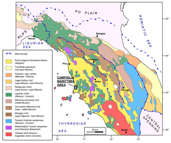
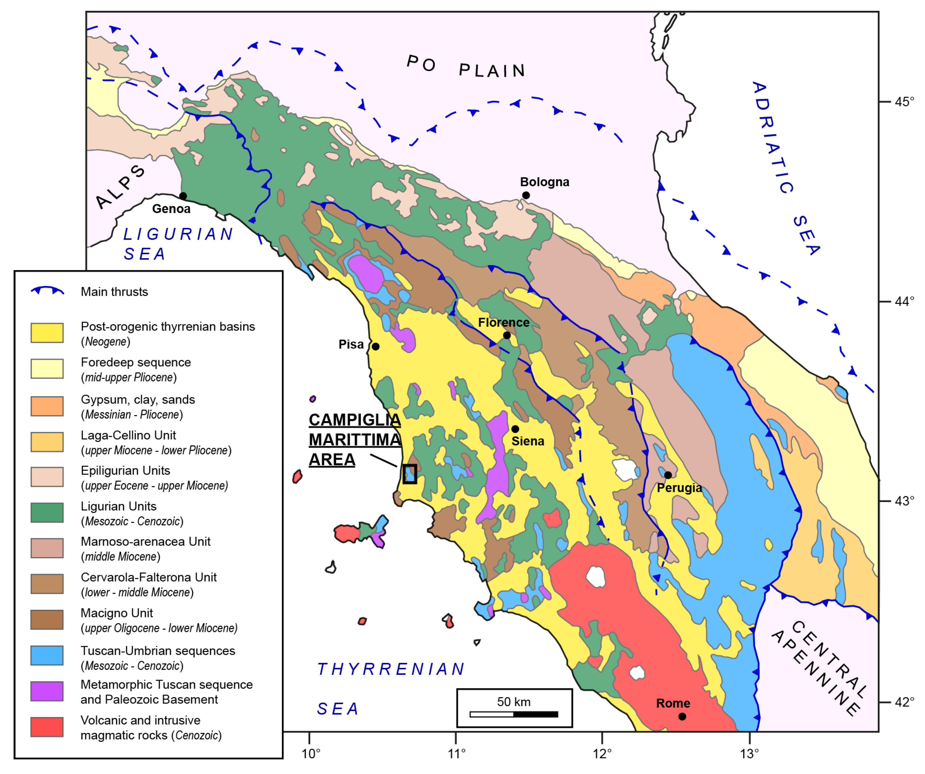
The purpose of this study is to provide a comprehensive overview, based on the aforementioned criteria, of the current state of knowledge regarding one of these historical stones: the Campiglia Marittima Marble (CMM), located near the village of Campiglia Marittima (southern Tuscany, Italy) (Figure 1).
Figure 1.
Location of the village of Campiglia Marittima within the geological framework of the Northern Apennines, Italy (elaboration G. Risaliti).
1.2. The Campiglia Marittima Marble
The CMM has been exploited since Etruscan times until the twentieth century [9,10,11]; despite this, CMM is relatively lesser-known compared to others, likely due to the competition with other Tuscan marbles, such as the variety from Montagnola Senese or the renowned Carrara Marble [12,13,14,15,16].
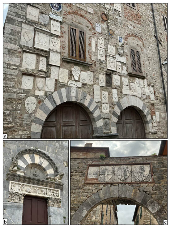
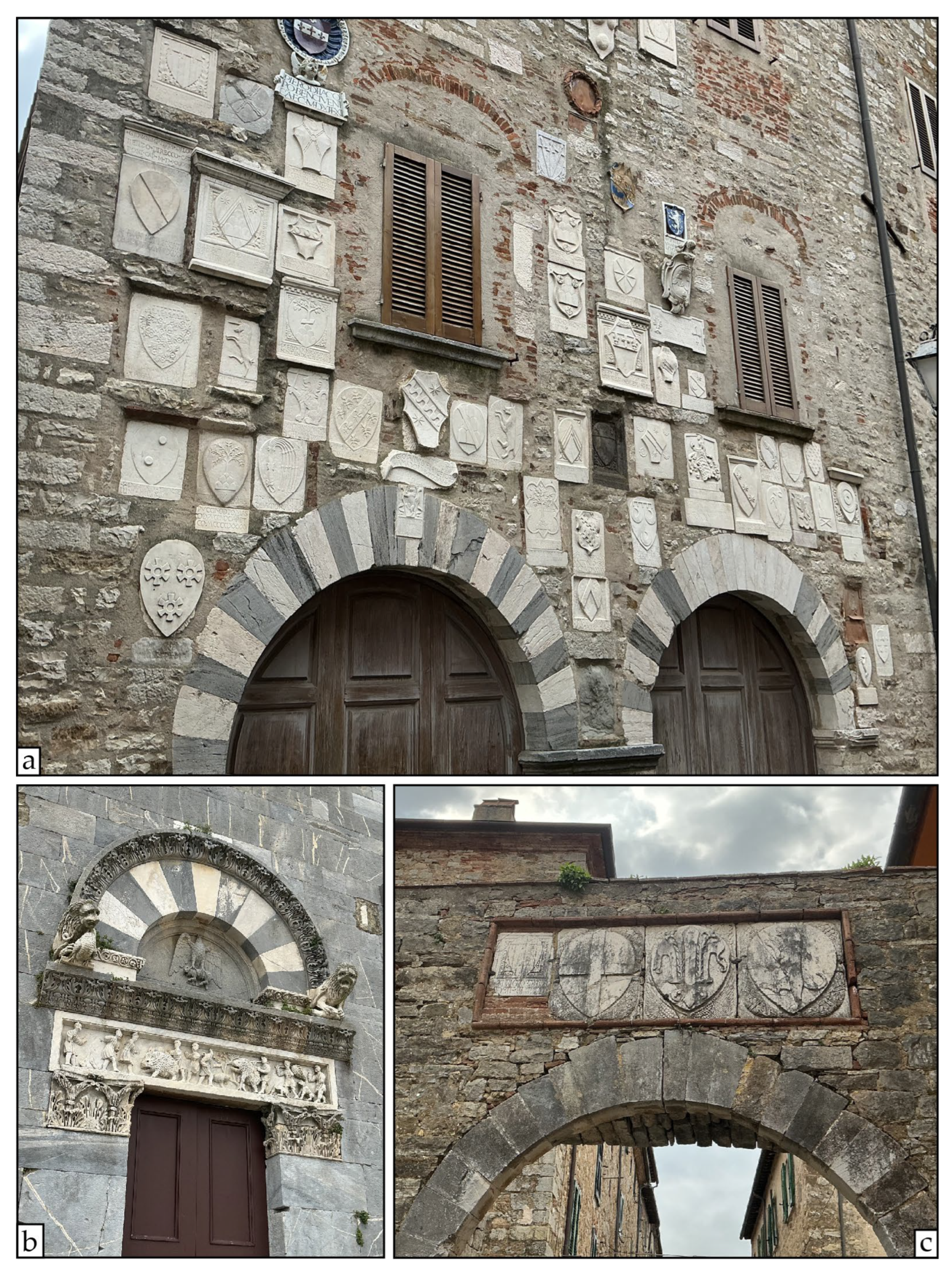
At present, when exploring Campiglia and its surrounding countryside, it is possible to observe numerous CMM quoins and ashlar blocks inserted into the masonry of medieval palaces and houses. These were probably reused from previous edifices, presumably of Roman origin. For example, on the façade of Palazzo Pretorio, the parish church of San Giovanni, or within the ancient city walls (Figure 2) [10].
Figure 2.
Examples of some buildings in Campiglia Marittima where CMM was used as quoins, ashlars or coats of arms. (a) Palazzo Pretorio; (b) external door of the parish church of San Giovanni; (c) northern gate of the city walls. (Photos by G. Risaliti).
The aim of this work is to compile and disseminate information concerning the CMM, providing useful data for its application in conservation and industrial contexts.
No further geochemical or petrographic analyses were performed in this study, as those available in the literature were deemed sufficient for our purposes. The focus of this paper is to provide, for the first time, a map of the CMM quarries, accompanied by a geological description and an overview of the main uses and exploitation phases which characterize the history of this marble and its relationships with human history.
2. Materials and Methods
The research was structured into a bibliographic review concerning marble quarrying and extraction in the Campiglia Marittima area, integrating new data with an extensive field survey of all identified marble quarries. Due to the scope and focus of the study, we concentrated exclusively on the marble quarries, without considering other kinds of resources present in the area, such as mines or quarries of different materials [17,18,19]. We identified CMM quarries based on historical maps, previous partial databases and studies, followed by comprehensive field survey aimed at recognizing quarries and the involved lithologies. For quarries that were particularly difficult to reach, an Unmanned Aerial Vehicle (UAV) was employed to acquire quarry images. The UAV was equipped with an FC3682_6.7 camera (SZ DJI Technology Co., Ltd., Shenzhen, China), capturing 4000 × 2250 px photos. Photos were processed via structure-from-motion photogrammetry using Pix4Dmapper v4.7.3 (Pix4D SA, Lausanne, Switzerland) to generate 3D models of the quarries. The ground resolution was between 2 and 9 mm/pix for each model. We georeferenced the quarries directly from the obtained photos, using GNSS/IMU positional data embedded within the image metadata. Mapping data were collected using the StraboField (StraboSpot Project, Lawrence, KS, USA) app and subsequently processed in QGIS v3.32 (QGIS.org, Grüt, Switzerland). We validated the data by comparing the identified quarry sites with the actual presence of quarry cuts, quarrying tools, or related traces.
The survey results are summarized in a map of the marble quarries located in the Campiglia Marittima area, correlated with a description of the lithological units involved. Although some databases or publications exist, they are limited to restricted areas and focus only on a few quarries or on certain specific aspects. Therefore, this is the first time that a comprehensive database concerning CMM quarries is presented.
2.1. Geological Setting
In this section, we summarize the geological setting and evolution of the Campiglia area, as synthesized from previously published studies; the aim is to provide a framework of the geological context concerning the CMM.
From a geological perspective, the Campiglia area is located in the inner sector of the Northern Apennines fold-and-thrust belt [20,21]. The area is tectonically characterized by a N-S elongated, triangular-shaped horst, primarily composed of carbonate rocks whose age spans from the Late Triassic to the Late Jurassic (Figure 3). The horst is delimited on its western side by a N-S trending, W-dipping normal fault; on its eastern side by a series of NNW-SSE trending, ENE-dipping normal faults; and on its southern side by a series of normal faults with variable orientations (Figure 3) [22,23,24,25]. From bottom to top, the main tectonic units outcropping in the area are (Figure 3) [24,25]:
- -
- The Tuscan Nappe, comprising, from base to top, platform carbonates, pelagic limestones, marls and shales, overlain by turbidite sandstones (Late Triassic—early Miocene).
- -
- The Subligurian Units, mainly consisting of shales, marls and sandstones (middle Eocene—early Miocene).
- -
- The Ligurian Units, comprising shales, marls, marly limestones and limestones (Jurassic to Eocene).
Neogene sedimentary deposits, mainly sand and silt (middle-Late Pleistocene), unconformably cover the aforementioned tectonic units.
In addition to these units, the Campiglia area is characterized by the presence of a magmatic complex, belonging to the Tuscan Magmatic Province [26], composed of granite, porphyry dikes and rhyolite, dated to the late Messinian—early Pliocene (Figure 3) [27,28]. This magmatic intrusion induced contact metamorphism and led to the formation of ore deposits within the intruded carbonates.
The Tuscan Nappe, Subligurian Units and Ligurian Units were tectonically stacked and thrust over each other during the main Apennine orogenic phase, between the late Oligocene and early Miocene; the Neogene sediments unconformably cover these tectonic units [20,21] and references therein, [24,25,29].
Figure 3.
Geological map of the Campiglia Marittima area (elaboration G. Risaliti; modified from [24,25,30]).
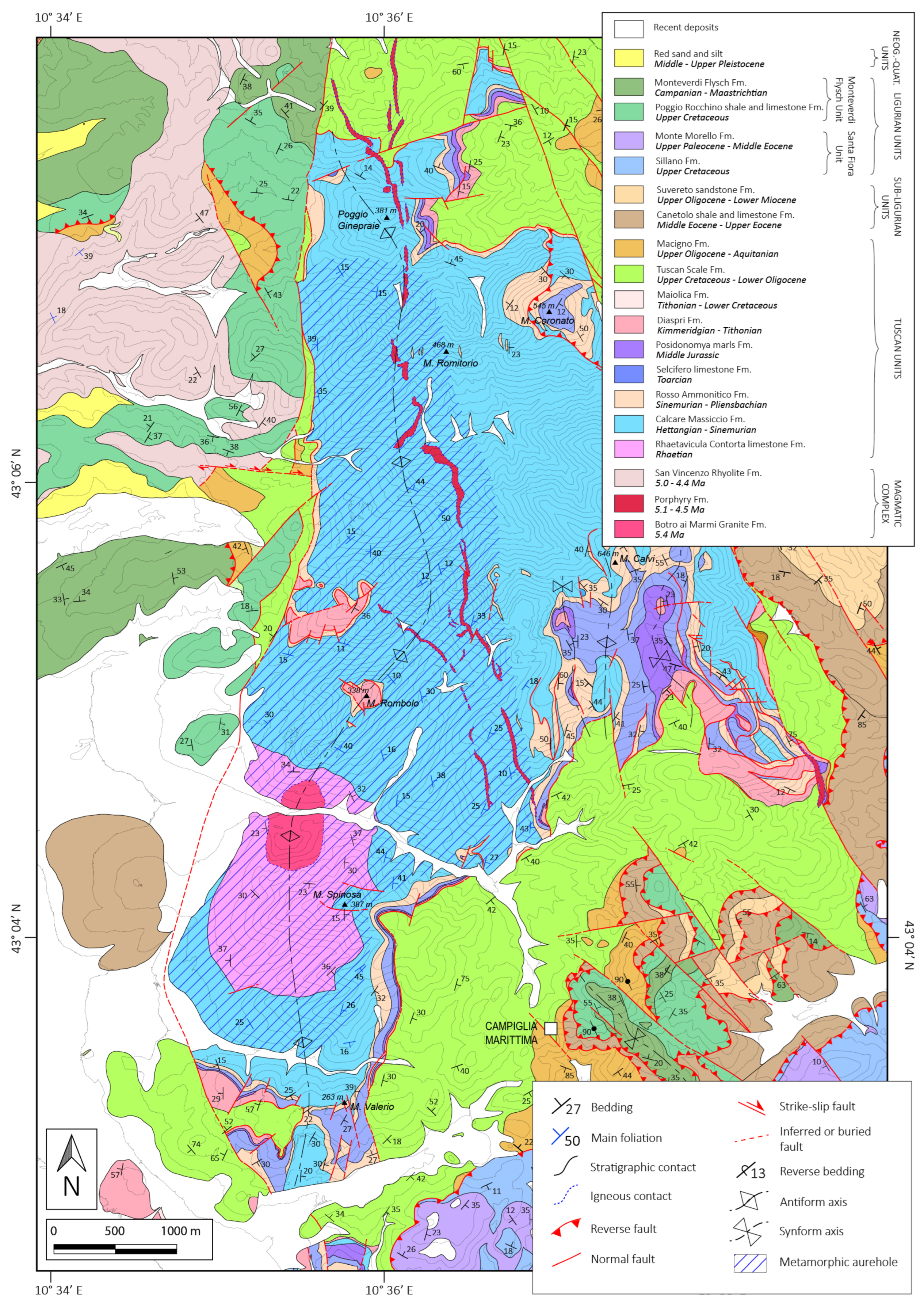
After the establishment of an extensional tectonic regime in the middle Miocene, since the late Miocene—Pliocene, high-angle normal faults have affected the area, leading to the formation of the Campiglia horst [22,23]. Here, formations belonging to the Tuscan Nappe outcrop; from bottom to top they are: the Rhaetavicula Contorta Limestone Fm. (Late Triassic), the Calcare Massiccio Fm., the Ammonitico Rosso Fm. and the Selcifero Limestone Fm (Early Jurassic), the Posidonomya Marls Fm. (Middle Jurassic), and the Diaspri Fm. (Late Jurassic; Figure 3).
In the late Messinian, an intrusive granitic body, the Botro ai Marmi Granite, emplaced up to a shallow level, causing the metamorphism of the host-rock around the intrusion. The main lithologies affected by metamorphism were the Rhaetavicula Contorta Limestone Fm. and the Calcare Massiccio Fm., which turned into marble (CMM), within the metamorphic aureole around the pluton (Figure 3) [22,23]. The age of the granite intrusion, which gave rise to the metamorphism, has been estimated at 5.4 Ma [28]. The emplacement took place at a depth of 3–4 km, corresponding to a pressure of 1–1.5 kbar [31]. The metamorphic temperature has been estimated in several areas of the aureole, reaching a maximum peak of 450 °C [31,32,33]. This value is in agreement with the metamorphic aureole thickness estimated to be around 500 m from the pluton contact [30].
After the pluton emplacement, the Porphyry Dikes Fm. and the San Vincenzo Rhyolite Fm. were intruded in several episodes, spanning from 5.1 to 4.4 Ma ago (Figure 3) [28], only locally affecting the host rocks with contact metamorphism.
The metamorphic aureole exhibits a N-S elongated shape; its length is approximately 6.5 km along the N-S direction and slightly over 2 km along the E-W direction (Figure 3). The main structure correlated with the aureole is a large antiform with a N-S axial direction, defined by the CMM layering attitude (Figure 3) [30,34,35]. The aureole is entirely included within the horst that characterizes the area; its western boundary coincides with the main N-S trending fault that bounds the horst, while its northern, eastern and southern limits are defined by a decrease in metamorphic grade, and thus are not precisely definable. The aureole’s shape reflects that of the underlying granitic body, as reconstructed through boreholes, reflection seismics surveys, and gravimetric maps [17,30,35]. This results in a N-S elongated shape, with two main apices: the southernmost, larger, and more significant one outcrops at Botro ai Marmi (Figure 3); a second, northernmost, less prominent apex is located between Poggio Ginepraie and the Dispense valley, with the top about 100 m below the ground datum.
During the last few decades, several authors have proposed different interpretations regarding the pluton emplacement mechanisms:
- -
- Some authors [22,23,35] proposed an intrusive body rising and emplacing in a fully extensional tectonic regime;
- -
- Others [34,36,37] suggested that magma rose by exploiting a releasing bend associated with the activity of a dextral strike-slip fault;
- -
- Recently, Ref. [30] proposed a compressive tectonic regime model, where the magma ascended by filling the core of an enucleating antiform fold (i.e., the main antiform that characterizes the aureole).
2.2. The CMM
The main characteristics of the CMM vary depending on both the nature of the protolith and the metamorphic temperature (i.e., the distance from the pluton) to which it was subjected.
Several commercial types of CMM have been recognized within the area, and quarried through time: Bardiglio Fiorito, Bardiglio, White and Broccatello [32,33,38]; a brief description of each is reported in Table 1.
Table 1.
Description of CMM types. (elaboration G. Risaliti).
CMM exhibits a strong to slight schistosity [30,34]. Even when schistosity is not readily visible at the mesoscale, a defined Shape Preferred Orientation (SPO) of calcite grains can be visualized via optical microscopy, by cutting the marble sample along the appropriate orientation (e.g., parallel to the XZ plane of the strain ellipsoid [39]).
According to calcite flow laws [40,41] and due to the estimated P-T conditions, the CMM grain size decreases with decreasing temperature as the distance from the pluton contact increases. Close to the Botro ai Marmi granite top, calcite grains reach 3–5 mm [32], whereas in the outermost zones of the aureole crystal dimensions exhibit values around 20–40 μm [30].
Grain boundaries are generally curved to lobate throughout the aureole, sometimes even amoeboid, and rarely straight; the texture is predominantly heteroblastic [30,32,33,38]. Bulging structures are also present, and, in places, the texture appears to be homeoblastic [38,42].
Petrographically, CMM is almost entirely pure marble, composed of more than 95% calcite crystals. Dolomite may be present, mainly in the grey marbles (Bardiglio and Bardiglio Fiorito), where it has been found occasionally constituting up to 7% or 10% of the compositional value [32]. Other accessory minerals that have been recognized include diopside, talc, quartz (mainly in veins), phlogopite, apatite, tremolite, chlorite, Fe-oxides, pyrite, and K-feldspar [30,31,32,38].
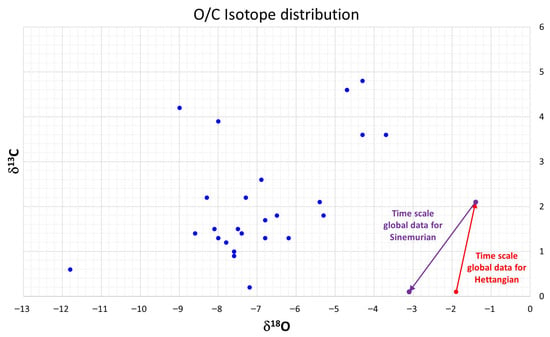
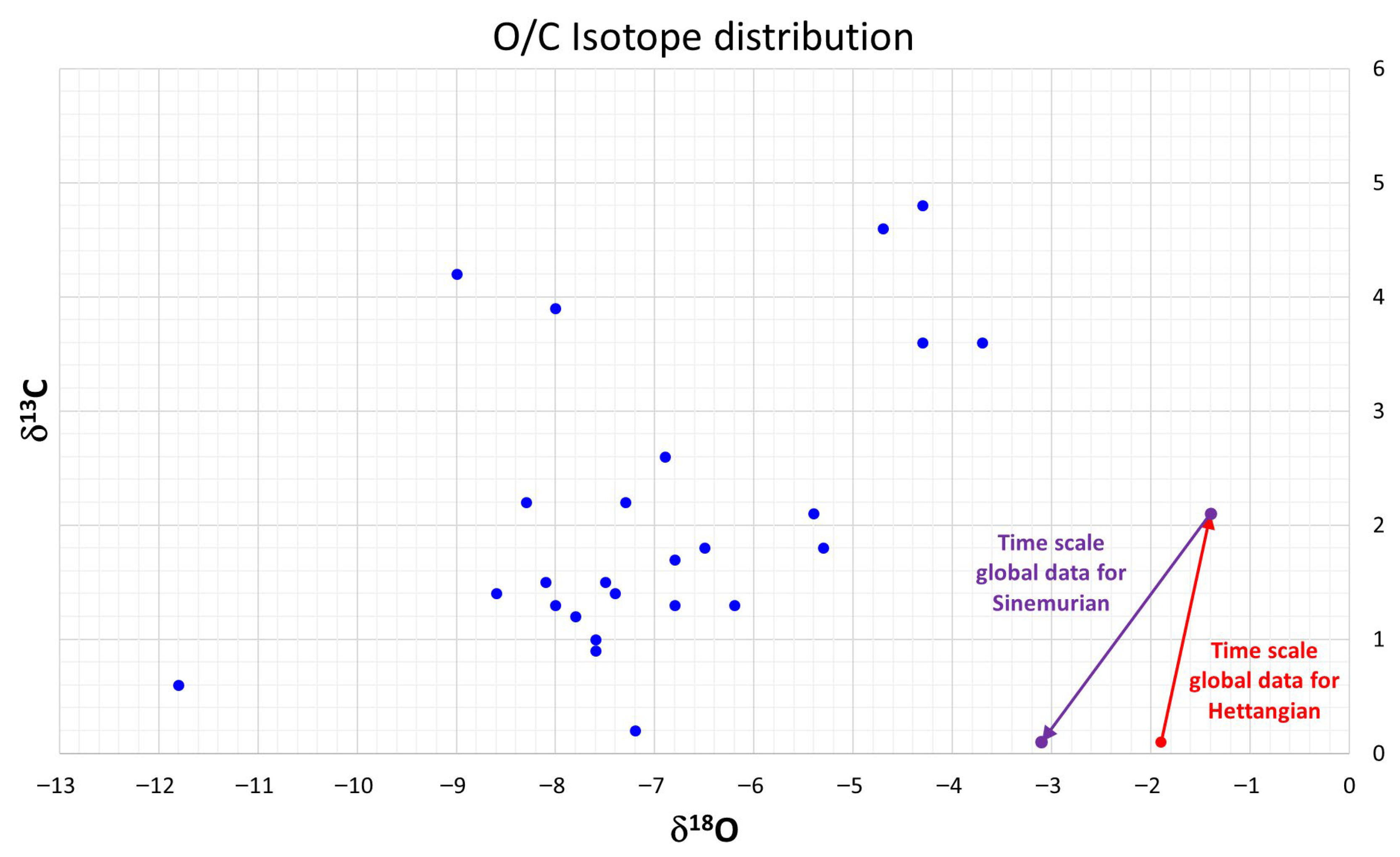
The O/C isotope data for Campiglia show δ18O ranging from −13 to −5 and δ13C from 0.5 to 2 (Figure 4) [32]. These data present no correspondence in the O/C isotope distribution with those from non-metamorphic platform carbonate rocks of the same age, as reported in the Global Time Scale (GTS) [43]. This lack of correspondence between the GTS data and these marbles was already outlined by [44] for the Carrara Marble, which derives from the tectono-dynamic metamorphism of the same protolith. This confirms the observations made by [44] regarding the limitations of using exclusively standard isotopic databases for identifying the provenance of marble artefacts in archeological contexts. A reliable attribution can only be derived from complementary technical analyses, such as EPR, trace elements analysis, and historical documents.
Figure 4.
O/C Isotope data for the Campiglia marbles (blue dots) and the reference data for the Hettangian (red dot and arrow) and Sinemurian (purple dots and arrow) in the Global Time Scale (elaboration M. Coli, data from [32]).
3. Results
3.1. Areal Distribution of Quarries
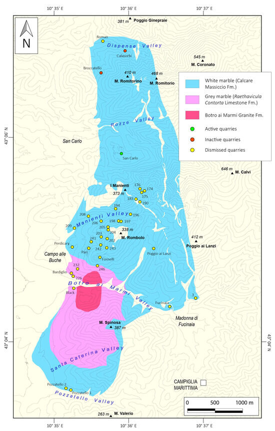
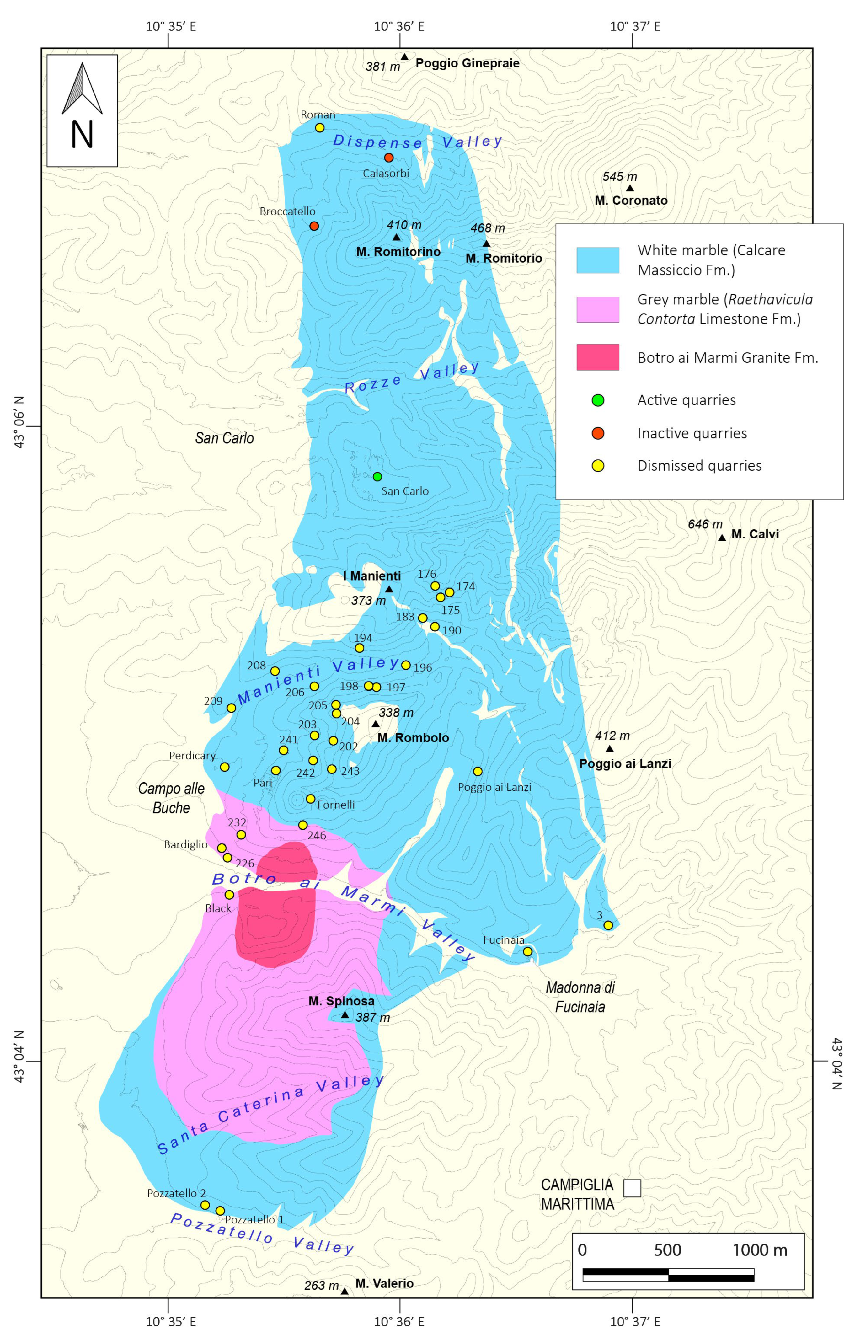
A total number of 36 quarries (Figure 5) have been surveyed, although some feature multiple extraction fronts due to their considerable size. Quarries are reported here by their common names; for those lacking one, the numbering system from the database (DB) of the San Silvestro Archeological Mining Park was adopted. This DB includes most of the quarries located between the Monte Rombolo area and the Manienti valley. Detailed data are reported in the Supplementary Material in Table S1 and as a .kmz file.
Figure 5.
Distribution of CMM quarries in the metamorphic aureole; the granitic outcrop of Botro ai Marmi and the distribution of the white and grey marbles are outlined (elaboration G. Risaliti).
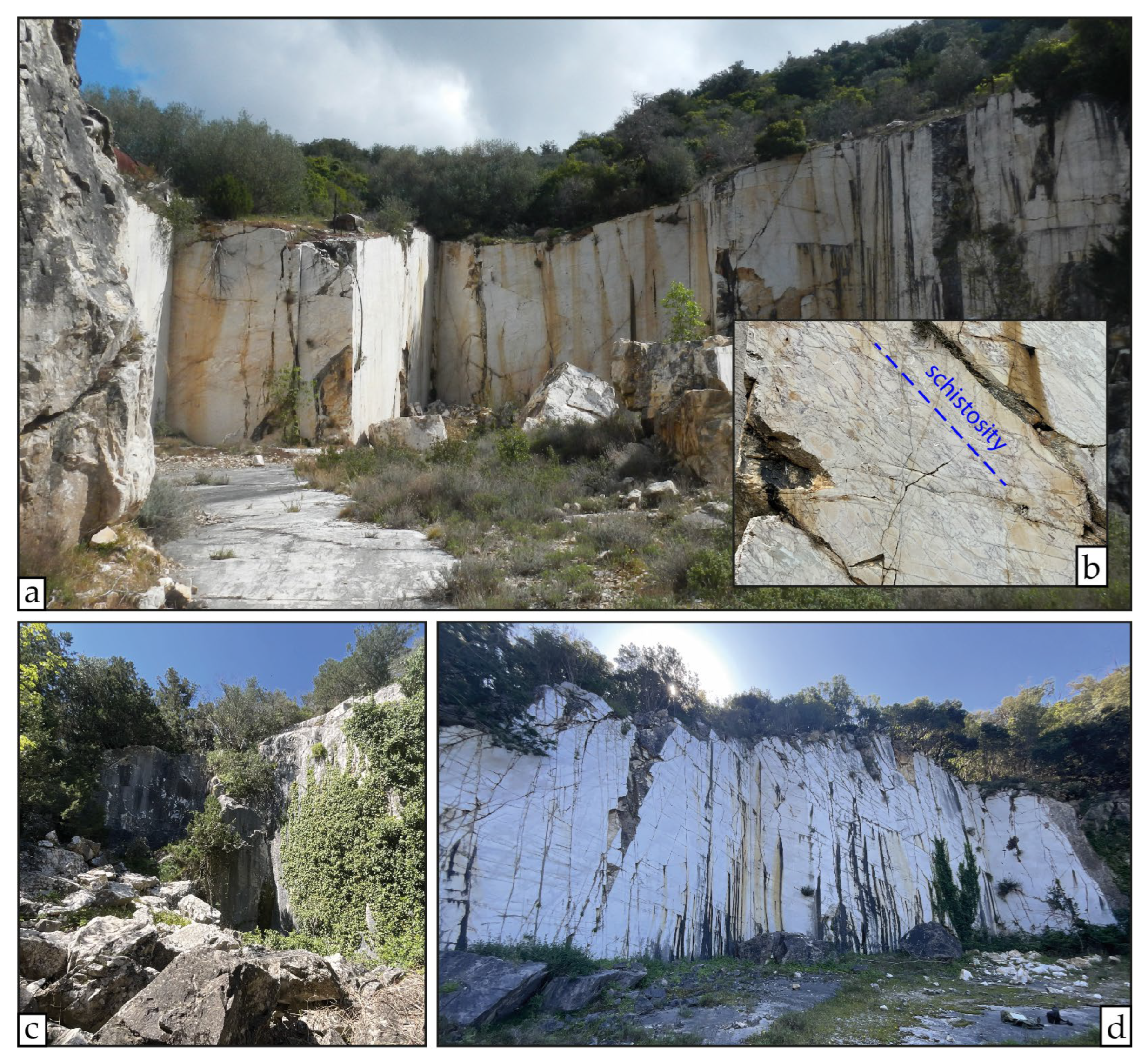
Most of the quarries are located in the area between Mt. Rombolo and the Manienti valley (Figure 5). On the Mt. Rombolo slopes, proceeding counterclockwise from the northern to the southern slope, there are quarries n. 197, 198, 206, 205, 204, 203, 202, 241, 242, 243, the Pari quarry, the Fornelli quarry, quarries n. 246 and 232, the Bardiglio quarry and quarry n. 226 (Figure 5). The last three mentioned are the only ones where the Bardiglio type, derived from the Raethavicula Contorta Limestone Fm. protolith, was extracted (Figure 5). The only other quarry within the same protolith is the Black quarry, located slightly further south at the northwestern slope of Monte Spinosa (Figure 5); it is the only one in this area where the Bardiglio Fiorito type has been quarried.
All the other quarries cited, except for the Broccatello quarry (which is discussed further below), were opened in the White marble type, whose protolith is the Calcare Massiccio Fm. Westward from Mt. Rombolo, in the locality of Campo alle Buche, quarry n. 209 and the Perdicary quarry are present (Figure 5). The latter is a large quarrying area that was worked during different periods, and where several extraction fronts have been reported (quarries n. 210, 211, 238 and 239 in the DB of San Silvestro Archeological Mining Park).
Northward, in the E-W oriented Manienti valley, going from west to east, quarries n. 208, 196 and 190 are close to the impluvium, whereas quarries n. 194, 183, 176, 175 and 174 are on the southern slope, on the right side of the valley (Figure 5).
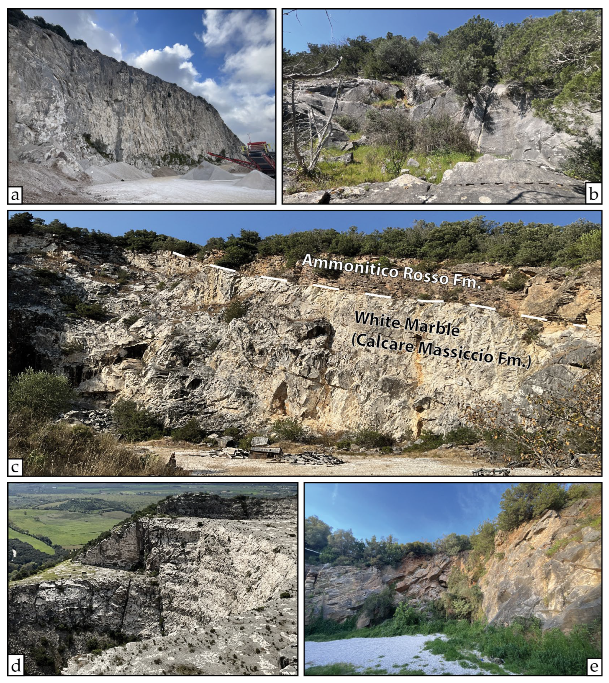
Eastward of Monte Rombolo, on the western slope of the Poggio ai Lanzi hill, there is the Poggio ai Lanzi quarry, where the park’s tourist railway runs today (Figure 5). Southward of the Poggio ai Lanzi hill, near the head of the Botro ai Marmi valley, the Fucinaia quarry is located where the stratigraphic contact between the Calcare Massiccio Fm. and the Ammonitico Rosso Fm. is visible (Figure 6c), along with quarry n. 3, near the eastern boundary of the metamorphic aureole (Figure 5). Progressing from the eastern to the southern limit of the aureole, within the Pozzatello valley, there are the Pozzatello quarries (1 and 2, from east to west), as named in the database of the Regional Quarries Plan of Tuscany (Figure 5) [45].
Figure 6.
Views of some quarries surveyed in the central part of the area of interest: (a) Pari quarry; (b) quarry n. 208; (c) Fucinaia quarry, where the stratigraphic contact between the Calcare Massiccio Fm. (White marble) and the Ammonitico Rosso Fm. is visible; (d) Fornelli quarries, with their typical funnel shape; (e) quarry n. 226, one of the few quarries within the Bardiglio marble type. (Photos by G. Risaliti).
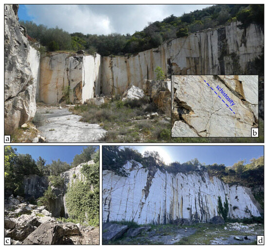
In the northern part of the area, the San Carlo quarry is located to the south of the Rozze valley, near the San Carlo locality, which gives it its name (Figure 5). More than 1 km to the north is the Broccatello quarry (also known as the Ortali or Romitorino quarry), on the northwestern slope of the Romitorino peak (Figure 5). This quarry is the only one where the protolith is not the Calcare Massiccio Fm. sensu stricto, but rather a heterometric, approximately monogenic, sedimentary breccia composed of clasts of Calcare Massiccio Fm., now aligned along the main schistosity (Figure 7a,b). Northward, within the Dispense valley, the final two quarries are located in the proximity of the northern boundary of the metamorphic aureole (Figure 5): the Roman quarry and the Calasorbi quarry (also known as the Valle delle Dispense quarry).
Figure 7.
Views of some quarries surveyed in the northern part of the area of interest: (a) Broccatello quarry; (b) detail of the Broccatello marble type within the Broccatello quarry, which is actually a metamorphic calcareous breccia, made up of clasts of the Calcare Massicio Fm.; clasts are aligned according to the main schistosity; (c) Roman quarry; (d) Calasorbi quarry. (Photos by M. Coli and G. Risaliti).
As stated above, marble grain size generally decreases with distance from the Botro ai Marmi Pluton top, (Figure 3) [30,32,33,38]. Therefore, quarries located in the inner sector of the aureole, such as those within the Raethavicula Contorta Limestone Fm. (the Pari quarry and the Fornelli quarry), tend to exhibit a larger grain size than those close to the aureole limit, such as the Pozzatello 1 and 2 quarries, the Roman quarry, or quarry n. 3.
The San Carlo quarry is the largest site, with an E-W linear dimension reaching almost 1 km. Other quarries with dimensions of several hundreds of metres in size are the Perdicary quarry, the Pari quarry and the Fornelli quarry—the latter comprising two excavation areas with a peculiar funnel shape—and the Poggio ai Lanzi quarry. All other quarries are of small size, with linear dimensions varying from a few metres to tens of metres.
Of all quarries covered by the study, according to the Regional Quarries Plan of Tuscany [45] the San Carlo quarry is currently active, while the Broccatello and Calasorbi quarries are inactive but included as potential quarrying sites (Figure 5). All other quarries are considered dismissed; of these the Pari quarry, owned by the Cave di Campiglia S.p.a., is currently used as a repository for quarry waste from nearby excavations of Calcare Massiccio used as aggregates.
3.2. Exploitation History of the CMM
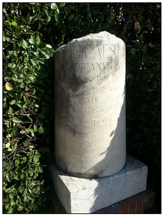
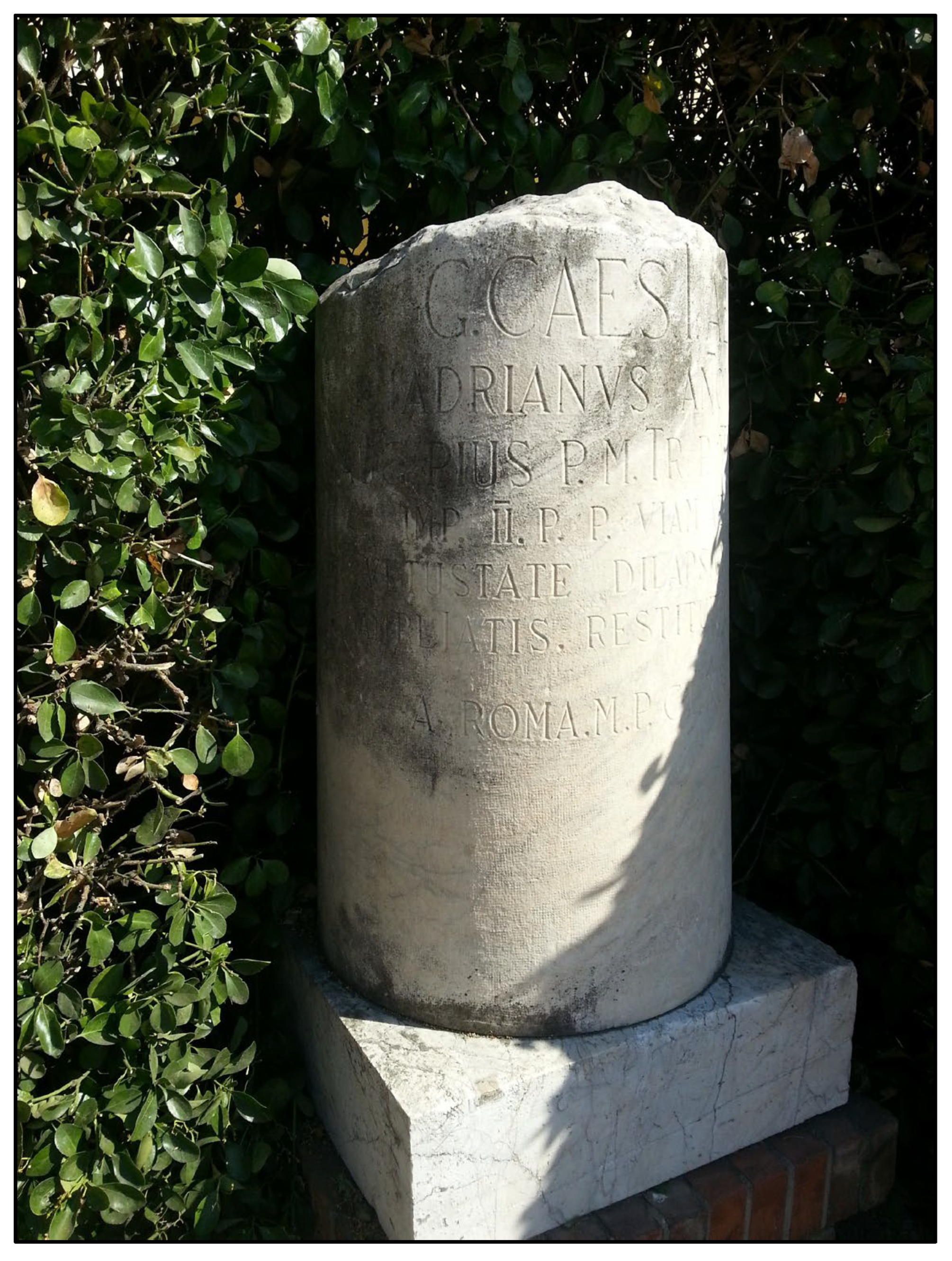
The CMM has been quarried and utilized sporadically at least since Etruscan times. Refs. [46,47] assessed that the Etruscans extracted the marble from the locality of Campo alle Buche, near the western flank of Mt. Rombolo (then known as the Perdicary quarry; Figure 5), during the fourth and third centuries BC. This period coincides with a time of significant expansion and prosperity for the nearby Etruscan city of Populonia, located on the coast. The hypothesis of an Etruscan excavation period was previously suggested by [9,48]. This was subsequently confirmed by [38,49], who compared marble from Campo alle Buche and other quarries within the Manienti valley (Figure 5) with artefacts from the city of Populonia, employing mineralogical-petrographic and isotopic analyses. The results show that the Etruscans quarried and utilized marble from these quarries (at least) during a period spanning from the Late Etruscan to the Early Roman era; ref. [50] documented that the Romans used the CMM to construct milestones along the ancient Via Aemilia in 140 AD, under Emperor Antoninus Pius (Figure 8), and that it was also employed for sculptures [9].
Figure 8.
CMM milestone along the roman Via Aemilia near Cecina. (Photo by M. Coli).
In the fifteenth century, Florence acquired the Campiglia area [50] and—given the difficulties in supplying marble from Carrara due to economic reasons and conflicts with Lucca and Pisa—the Opera del Duomo of Florence (OPA), which since 1296 has been responsible for the construction and conservation of the Florence Cathedral (including Brunelleschi’s Dome and Giotto’s Bell Tower), organized the following expeditions to Campiglia to obtain marble slabs for cladding the aisle of the Cathedral (see in the online archive of the OPA at [51]):
- -
- April 1434: First expedition to Campiglia to the ancient Roman quarry to extract a few test blocks, with Battista d’Antonio (Master Builder), Cecco Andrea Fraschetta from Settignano, and other masters.
- -
- June 1434: Second expedition to Campiglia, conducted by Cecco Andrea Fraschetta from Settignano (Master Builder), Baccio d’Antonio (Assistant Master Builder), Giovanni d’Antonio di Giusto from Settignano, Battista d’Antonio, Nicola, Nanni di Berto, and Cecco di Meo di Cecchino.
- -
- October 1434: Third expedition to Campiglia, including Filippo Brunelleschi, Bindaccio d’Albertaccio da Ricasoli, Battista, and others.
- -
- 1470: Visit to the Campiglia quarries by Lorenzo de’ Medici accompanied by the workers of the Opera.
According to [9,52], during this time, CMM was used to clad the exterior walls of the rear aisle, the eastern sides of the drum (Tamburo) and the top of the Lanterna of the Florence Cathedral, as well as for the external slabs of the guard tower of San Vincenzo.
In the sixteenth century, four quarries were active in Campiglia, for which the OPA held the direct concession and where with its own workers were employed; these quarries were visited by Cosimo I de’ Medici, Grand Duke of Tuscany, in 1558 and 1561. He recommended the use of the CMM to the famous artists Giambologna and Bartolomeo Ammannati [9,10,11,53,54]. Ammannati requested CMM to create the Giunone Fountain in Piazza della Signoria in Florence; however, for unknown reasons—likely related to transport difficulties or issues during the extraction—the artist eventually utilized Carrara Marble [55].
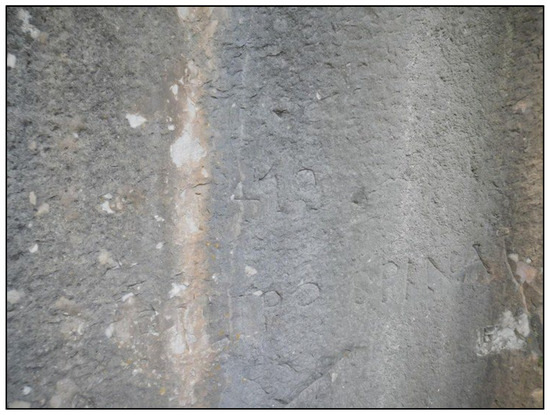
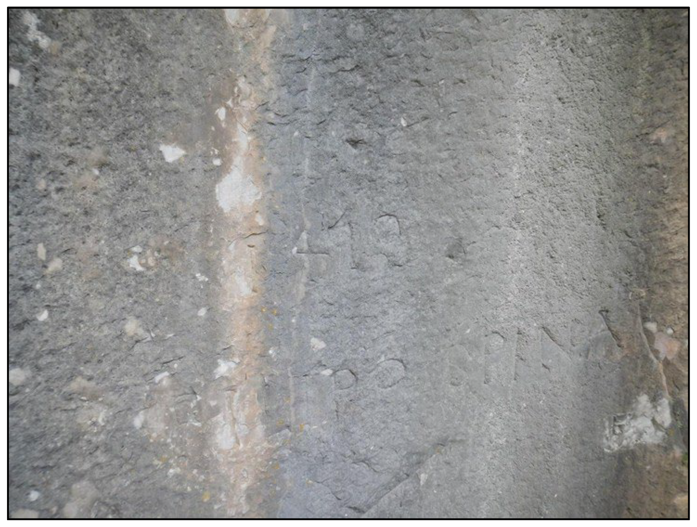
It is not clear which quarries were opened during those centuries [9,50,52,54,56]; certainly, the Roman quarry was partly reopened, as dates and signatures from that period are engraved on its extraction fronts, and it produced a beautiful White marble (Figure 9).
Figure 9.
Engraving on a cut of the Roman quarry: “1418, Filippo Spina”. (Photo by M. Coli).
After more than 200 years, the marble quarries in Campo alle Buche were reopened by the entrepreneur Vassili Perdicary, who invested in and promoted CMM quarrying and sales between 1845 and 1878 [9,10,11,57]. This activity attracted the attention of numerous artists and sculptors from all over the world, who incorporated this marble into their works: Lorenzo Bartolini, Pietro Tenerani, Giovanni Duprè, Anton Hautmann, Hiram Powers, Max Ymkof, Albert Wolff, Johan Niclas Byström and Luigi Bienaimé are among them [9,58].
After Perdicary’s death in 1878, the Monte Rombolo quarries and the surrounding lands were acquired by the Lippi family from the village of San Vincenzo, who only sporadically sold the marble between the end of the nineteenth and the first decades of twentieth century [10,11]. In fact, until around 1930, marble was still extracted from the locality of Campo alle Buche [9,47,59].
Starting from 1900, CMM was used as a fluxing agent in steel production at Piombino, first by the S.T.I.A.M. company and subsequently by the ILVA S.p.A. [9,10,11]. For this reason, the Fornelli quarries were developed, with their typical funnel shape, between 1940 and 1960 (Figure 6d).
As shown by historical aerial photos [60], during the second half of the last century, the Poggio ai Lanzi quarry, the Broccatello quarry and the Calasorbi quarry were active, the latter two as CMM extraction sites for ornamental purposes. Ref. [56] reports other quarries in the area near Mt. Romitorio opened at that time, such as the Broccatello quarry (Figure 5).
Today, the only active CMM quarry is the San Carlo quarry, opened in 1927 and managed by the Solvay company for industrial purposes (Figure 5); in the near future, the reopening of the Broccatello quarry is planned.
4. Discussion
We listed a total number of 36 CMM quarries (Figure 5 and Supplementary Material). It should be noted that the actual number could be higher, and some quarries may have been missed. This could be due to two main reasons: the first is the high growth rate of vegetation in this part of Tuscany, which may have entirely obliterated small quarries, especially ancient ones; the second is the opening of new and larger quarries through time (such as the Perdicary or San Carlo quarries), which may have incorporated previous, smaller excavations.
Furthermore, it is difficult to provide a more accurate attribution of the quarries’ ages. Previous authors based their attributions on relative relationships between different extraction traces, the age of the quarrying tools employed, or by comparing samples from the quarries with the marble used in certain artefacts and works of art [38,46,47,49]. In this paper, we added information derived from both scientific and historical sources, both classical and recent.
The presented results show that most of the CMM quarries are located in the area between the western slope of Monte Rombolo and the Manienti valley (Figure 5). This is the same area where CMM has undoubtedly always been extracted, at least since Etruscan times [38,49]. The reason why this part of the Campiglia area has persistently been the preferred one for quarrying (until recent times) is attributable to at least two main aspects. The first is its position at the valley bottom, relatively close to the sea and to the main thoroughfares that link Campiglia Marittima with the coast, where major connecting roads have existed since Etruscan and Roman times [9,58], offering the possibility for the marble to be transported by sea.
The second aspect is the high variability of commercial marble types present there; in fact, in this area, several commercial marble varieties have been proposed for the White marble through time, which should be added to the ones distinguished in Table 1. In the mid-nineteenth century, the famous geologist Paolo Savi, together with other geologists and sculptors, was sent to observe and evaluate the CMM in the quarries near Campo alle Buche by the owner Vassili Perdicary, to assess the quality of the marble marketed by his enterprise [58]. They all agreed that the White marble excavated in Campo alle Buche, where the grain size is coarse (≈1 mm; Perdicary quarry in Figure 5), was very similar, or even identical, to the classic Pario marble from Greece, in both esthetic and physical characteristics. Moving to the quarries in the upper part of Mt. Rombolo, or on its north-western slope, or within the Manienti valley (Figure 5), where the grain size is smaller (≈0.4–0.7 mm), the White marble was classified by the same authors as similar to the Statuario or Ordinario marble types from Carrara. Where even smaller grains were found (≈0.1 mm), they compared the CMM to the classical Grechetto marble from Africa [9,58].
Of course, these commercial varieties of White marble were added to the grey marbles Bardiglio (or Bardiglio Turchino) and Bardiglio Fiorito [58]. The same varieties have been described for CMM even in recent times, in magazines specifically dedicated to marble workers and quarrymen [10]. Also, in the case of the Broccatello marble type, different commercial names are actually used, such as “Calacatta Gherardesca” or “Misto Gherardesca” [61].
It is clear that the aforementioned qualities and variations in CMM are strictly related to its geological nature. This is true not only when considering the difference in protolith between the Grey Marble and the White Marble (i.e., Raethavicula Contorta Limestone and Calcare Massiccio, respectively), but also considering the decrease in grain size with increasing distance from the pluton [30,38], which confers different characteristics to the marble that can be translated into different commercial types.
According to [47], it is therefore highly probable that some of the marble that was sold and used as “Greek marble”, especially during the excavation activities of the nineteenth century, was actually CMM, and not the original Pario. The same reasoning could be applied to the Grechetto marble from Africa, or to the Statuario or the Ordinario marbles from Carrara. This leads to the current challenge of identifying which buildings, statues, sculptures or other works of art are actually made with CMM rather than marble coming from other extraction sites, and vice versa.
A reliable attribution of works of art to a certain type of marble can be made according to different approaches [44]:
- -
- Archival data.
- -
- Technical analyses regarding mineralogy-petrology, O/C isotopes and EPR.
- -
- Expert judgement.
Today, based on the current state of the art, some of the monuments and buildings where the use of CMM is confirmed are:
- -
- In Campiglia Marittima, as quoins and ashlars on Palazzo Pretorio, on the parish church of San Giovanni and on the city walls (Figure 2) [10,11].
- -
- In San Vincenzo, for the external curtain of the Guard Tower and for the former Palazzo Lippi [9,10].
- -
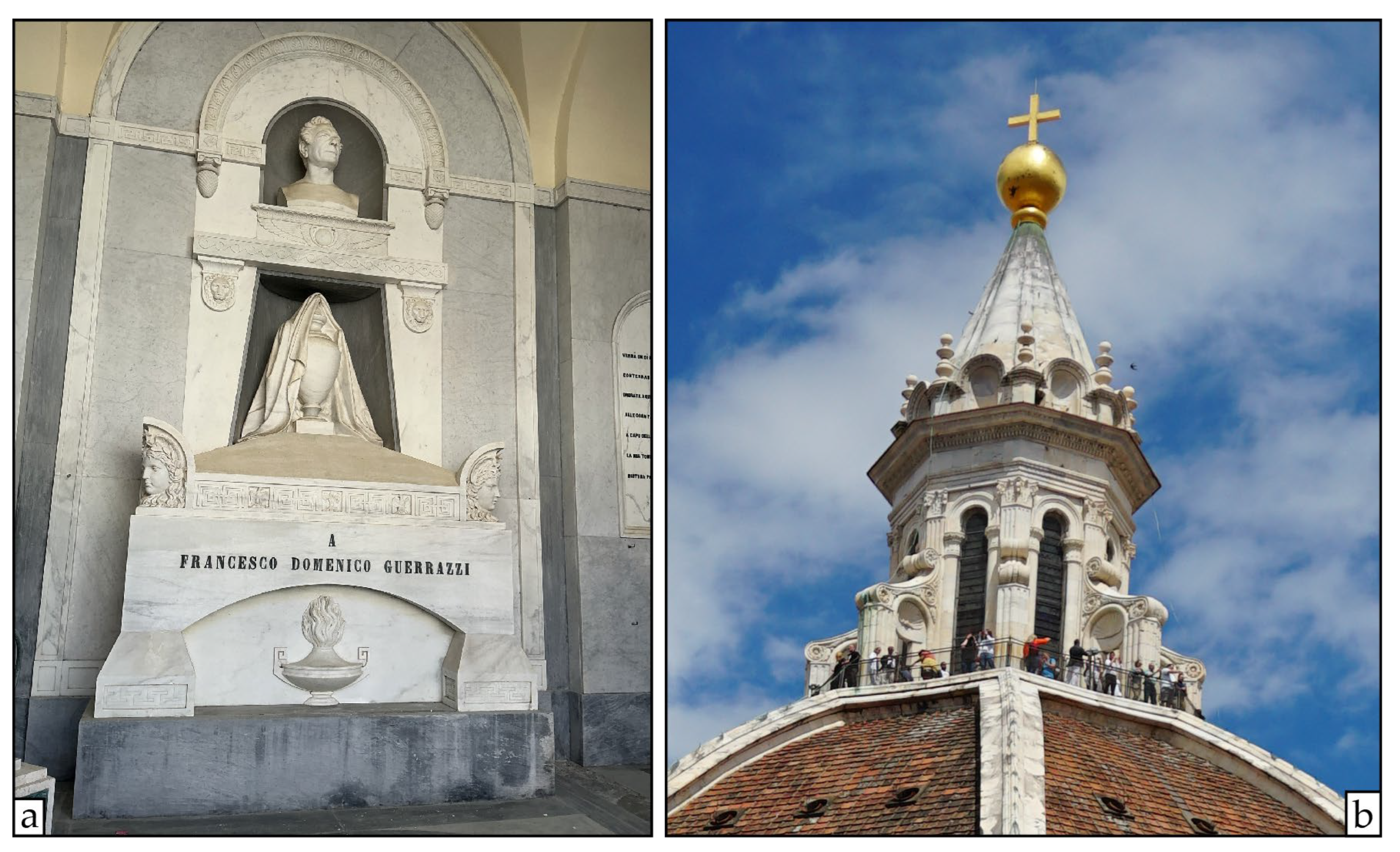
- In Livorno, for some tombs in the monumental cemetery of Montenero (Figure 10a) and, probably, in the Greek Orthodox cemetery.Figure 10. Examples of some monuments made of CMM. (a) Tomb of Francesco Domenico Guerrazzi at the cemetery of Montenero, Livorno. (b) The Lanterna of Brunelleschi’s Dome of the Santa Maria del Fiore Cathedral in Florence; the top cone is made of CMM. (Photos by G. Risaliti and M. Coli).
- -
- In Florence, as slabs in the cladding of the rear aisle and the eastern sides of the drum (Tamburo) and the top cone of the Lanterna of Brunelleschi’s Dome of the Santa Maria del Fiore Cathedral (Figure 10b), for the head of Filippo Brunelleschi on his tomb in the same Cathedral, for the base of the Statue of Dante Alighieri by Enrico Pazzi, and in the Cappella dei Principi at the San Lorenzo Church [9,52,56].
- -
- In Pisa, for the external cladding of the Baptistery and the Santa Maria della Spina Church [56].
- -
- In Siena, for the statue of Pius II within the Sant’Agostino Church [9].
There is no doubt that CMM has always been appreciated by those who worked with it; as proof, its history has been linked with human history for more than 2300 years. In the letters written by the artists and the geologists sent by Perdicary to the CMM quarries, they confirm that CMM is a high-quality marble, and they are enthusiastic about the works of art they can produce with it [58]. Even [9], already in 1936, was surprised by the fact that CMM was not exploited for stone uses at that time, despite its excellent quality. Certainly, CMM has historically faced competition with other Tuscan marbles, such as Carrara Marble or the Montagnola Senese Marble [15]. In our opinion, this is not due to differences in the value of the main physico-mechanical properties, which appear to be comparable (Table 2).
Table 2.
Physical–mechanical properties data for the three mentioned Tuscan marbles; data from [13,32,42,62] (elaboration G. Risaliti and M. Coli).
No production or economic data concerning CMM marketing were found in the literature or archives; the fact that CMM has been used as a substitute for other marbles (Carrara Marble, Pario, Grechetto…) suggests that its quality and properties are comparable to those of the latter. Important aspects limiting the supply of marble from Campiglia were the lack of infrastructures, such as roads and harbours, and historical factors like the presence of Saracen pirates and Spanish incursions. Furthermore, the high degree of fracturing affecting the CMM [33], which limits the possibility of exploiting large blocks (especially compared with Carrara Marble), likely also played a role.
5. Conclusions
In this work, we provided an outline of a historical stone, the Campiglia Marittima Marble (CMM), from Tuscany, Italy. A preliminary geological description of this material was accompanied by a summary of its main excavation periods and historical uses, and a comprehensive map of all identified CMM quarries is presented.
CMM is a thermal-metamorphic marble; it has been quarried since Etruscan times up to the present day, although currently it is utilized exclusively for industrial purposes. The majority of the quarries are situated in the central-western part of the metamorphic aureole, between the Botro ai Marmi valley and the Manienti valley, where the greatest variety of commercial marble types is present.
Despite currently being relatively lesser-known, likely due to historical competition with other local marbles, CMM has always been appreciated by the artists and craftsmen who worked with it, and its history is unequivocally linked with human history, especially in Tuscany and Italy. For these reasons, it deserves a distinctive title, commensurate with all the stones that have made a crucial contribution to progress and human civilization.
Hopefully, in the future it will be quarried again, for restoration, industrial or even ornamental purposes; in fact, in the Regional Quarries Plan of Tuscany, the quarry sites of Broccatello and Calasorbi are included as potential extractive areas. Indeed, the reopening of the Broccatello quarry is planned for the near future. This demonstrates the quality, durability and extraction feasibility of CMM, highlighting the economic and technical potential of the CMM in the contemporary dimension stone market.
To the authors’ knowledge, this is the first time that a comprehensive study on this material has been published, with the aim of restoring the cultural memory of this marble.
Supplementary Materials
The following supporting information can be downloaded at: https://www.mdpi.com/article/10.3390/heritage9050190/s1, Table S1: List of the quarries of CMM; Campiglia_quarries.kmz (.KMZ file).
Author Contributions
Conceptualization, M.C. and G.R.; methodology, M.C. and G.R.; software, G.R.; validation, M.C., S.M. and G.R.; formal analysis, G.R.; investigation, G.R. and S.M.; resources, M.C.; data curation, G.R. and S.M.; writing—original draft preparation, M.C. and G.R.; writing—review and editing, M.C., G.R. and S.M.; visualization, M.C., S.M. and G.R.; supervision, M.C.; project administration, M.C.; funding acquisition, M.C. All authors have read and agreed to the published version of the manuscript.
Funding
This research was funded by Opera del Duomo di Firenze, grant number COLI18FABBRICERIAOPERADUOMO.
Data Availability Statement
Data are contained within the article.
Acknowledgments
We would like to thank the three anonymous reviewers for their valuable and constructive suggestions, which helped to improve the quality of the paper. Acknowledgments to the Opera del Duomo di Firenze for funding the research and the Parco Archeominerario di San Silvestro for the cooperation and the permission to operate in the area.
Conflicts of Interest
The authors declare no conflicts of interest. The funders had no role in the design of the study; in the collection, analyses, or interpretation of data; in the writing of the manuscript, or in the decision to publish the results.
References
- Coli, M.; Marino, L. Principles of Natural Stones Use and Practices from the Western Side of the Silk Road. ISRM News J. 2008, 11, 74–81. [Google Scholar]
- Rodolico, F. Le Pietre della Città d’Italia; Ed. Le Monnier: Firenze, Italy, 1953. [Google Scholar]
- Redi, F. Edilizia Medievale in Toscana; Edifir: Firenze, Italy, 1989; 256p. [Google Scholar]
- Hudson, J.; Cosgrove, J. Understanding Building Stones and Stone Buildings; CRC Press: Boca Raton, FL, USA, 2019; 349p. [Google Scholar]
- Pardi, F. Note per la lettura del paesaggio fisico. In La Conservazione del Paesaggio, a Cura di Simona Carnevale; Restauro Archeologico/9, Collana Diretta da Luigi Marino; Alinea Editrice: Firenze, Italy, 2003. [Google Scholar]
- Basso, E.; Bernardi, P.; Pinto, G. Le Pietre Delle Città Medievali: Materiali, Uomini, Tecniche (Area Mediterranea, Secc XIII–XV); Centro Int. Stud. Insed. Medievali (Eds.): Cherasco, Italy, 2020. [Google Scholar]
- Maggetti, M. La pierre dans les villes européennes: L’exemple de Fribourg (Suisse). In Le Pietre Ornamentali della Montagna Europea/Dimension Stones of the European Mountains; Seminario Internazionale/International Workshop: Luserna San Giovanni–Torre Pellice, Italy, 2001. [Google Scholar]
- Russel, B. The Economics of the Roman Stone Trade; Oxford University Press: Oxford, UK, 2013; 449p. [Google Scholar]
- Merciai, G. I marmi di Monte Rombolo presso Campiglia Marittima. Atti Soc. Tosc. Sci. Nat. Ser. A 1936, 46, 61–73. [Google Scholar]
- Mancini, S.; Muti, A.; Benedettini, G. I marmi del territorio di Campiglia Marittima. L’inf. Marmista 2014, 629, 32–44. [Google Scholar]
- Mancini, S.; Muti, A.; Sbrilli, L. Le cave di marmi e altre pietre ornamentali della costa degli Etruschi. Il Geol. 2015, 97, 4–9. [Google Scholar]
- Coli, M. Litho-structural assemblage and deformation history of “Carrara Marble”. Boll. Soc. Geol. It. 1989, 108, 581–590. [Google Scholar]
- Coli, M.; Pini, G.; Piccini, L.; Mariottoni, E.; Frosini, S.; Rossi, L.M.; Livi, E.; Appelius, V.; Carmignani, L.; Meccheri, M.; et al. Studi conoscitivi sui bacini Marmiferi Industriali del Comune di Carrara: Un contributo per la gestione pianificata delle attività. Quad. GEAM 2002, 24, 6–100. [Google Scholar]
- Coli, M.; Criscuolo, A. The Carrara Marble: Geology, geomechanics and quarrying. Mechanics and Rock Engineering, from Theory to Practice. In IOP Conference Series: Earth and Environmental Science; IOP Publishing: Bristol, UK, 2021; Volume 833, 8p. [Google Scholar] [CrossRef] [Scilit]
- Coli, M. I marmi storici toscani: Note per un approfondimento. In La Toscana del Marmo; Pacini Editore: Pisa, Italy, 2022; pp. 181–204. [Google Scholar]
- Molli, G. Geology of The Alpi Apuane and their marbles: An update overview. Atti Della Soc. Toscana Sci. Nat. Resid. Pisa Mem. Ser. A 2024, 131, 91–105. [Google Scholar]
- Acquater, S. Area Campigliese, Convenzione Ministero Industria, Commercio e Artigianato—ENI.; Relazione Conclusiva Sui Lavori Svolti; Internal Report; Aquater SpA: San Lorenzo in Campo, Italy, 1994. [Google Scholar]
- Da Mommio, A.; Iaccarino, S.; Vezzoni, S.; Dini, A.; Rocchi, S.; Brocchini, D.; Guideri, S.; Sbrilli, L. Valorizzazione del geosito «sezione Coquand», Miniera del Temperino (Parco Archeominerario di San Silvestro, Campiglia Marittima). Atti Della Soc. Toscana Sci. Nat. Resid. Pisa. Mem. Serie A 2010, 115, 55–72. [Google Scholar]
- Vezzoni, S.; Rocchi, S.; Dini, A. Campiglia Marittima Skarn (Tuscany): A challenging example for the evolution of Skarn-Forming models. Minerals 2023, 13, 482. [Google Scholar] [CrossRef] [Scilit]
- Boccaletti, M.; Coli, M.; Decandia, A.; Giannini, E.; Lazzarotto, A. Evoluzione dell’Appennino settentrionale secondo un nuovo modello strutturale. Mem. Della Soc. Geol. Ital. 1980, 21, 359–373. [Google Scholar]
- Conti, P.; Cornamusini, G.; Carmignani, L. An outline of the geology of the Northern Apennines (Italy), with geological map at 1:250,000 scale. Ital. J. Geosci. 2020, 139, 149–194. [Google Scholar] [CrossRef] [Scilit]
- Giannini, E. Geologia dei Monti di Campiglia Marittima (Livorno); Pacini Mariotti: Pisa, Italy, 1955. [Google Scholar]
- Costantini, A.; Lazzarotto, A.; Maccantelli, M.; Mazzanti, R.; Sandrelli, F.; Tavarnelli, E.; Elter, F.M. Geologia della provincia di Livorno a sud del Fiume Cecina. Quad. Mus. Stor. Nat. Livorno 1993, 13, 1–164. [Google Scholar]
- Cerrina Feroni, A.; Fedeli, A.; Martinelli, P.; Ungari, A.; Baldacci, F.; Masetti, G. Carta Geologica della Toscana Alla Scala 1:10.000, Sezione 305080, Sassetta; CNR–Istituto di Geoscienze e Georisorse: Regione Toscana, Italy, 2007. [Google Scholar]
- Cerrina Feroni, A.; Fedeli, A.; Ungari, A.; Catanzariti, R.; Masetti, G. Carta Geologica della Toscana Alla Scala 1:10.000, Sezione 305120, Campiglia Marittima; CNR–Istituto di Geoscienze e Georisorse: Regione Toscana, Italy, 2007. [Google Scholar]
- Peccerillo, A. The Tuscany Province. In Cenozoic Volcanism in the Tyrrhenian Sea Region; Advances in Volcanology; Springer: Cham, Switzerland, 2017. [Google Scholar] [CrossRef] [Scilit]
- Barberi, F.; Innocenti, F.; Mazzuoli, R. Contributo alla conoscenza chimico-petrografica e magmatologica delle rocce intrusive, vulcaniche e filoniane del Campigliese (Toscana). Mem. Soc. Geol. Ital. 1967, 6, 643–681. [Google Scholar]
- Di Vincenzo, G.; Vezzoni, S.; Dini, A.; Rocchi, S. Timescale of a magmatic-hydrothermal system revealed by 40Ar–39Ar geochronology: The Mio-Pliocene Campiglia Marittima system (Tuscany, Italy). Sci. Rep. 2022, 12, 7128. [Google Scholar] [CrossRef] [Scilit] [PubMed]
- Molli, G. Northern Apennine–Corsica orogenic system: An updated overview. In Tectonic Aspects of the Alpine-Dinaride-Carpathian System; Siegesmund, S., Fügenschuh, B., Froitzheim, N., Eds.; Geological Society: London, UK, 2008. [Google Scholar] [CrossRef] [Scilit]
- Papeschi, S.; Bonini, M.; Lanari, R.; Del Ventisette, C.; Montanari, D. Growth of a magma-filled antiform from granite emplacement to post-intrusive cooling: The Campiglia Marittima study case (Northern Apennines, Italy). Lithos 2025, 504, 108053. [Google Scholar] [CrossRef] [Scilit]
- Leoni, L.; Tamponi, M. Thermometamorphism in the Campiglia Marittima aureole (Southern Tuscany, Italy). Neues Jahrb. Fur Mineral. Monatshefte 1991, 4, 145–157. [Google Scholar]
- Franzini, M.; Lezzerini, M.; Origlia, F. Marbles from the Campiglia Marittima area (Tuscany, Italy). Eur. J. Mineral. 2010, 22, 881–893. [Google Scholar] [CrossRef] [Scilit]
- Lezzerini, M.; Civita, J.; Aquino, A.; Pagnotta, S. Marbles from Castagneto Carducci Area (Tuscany, Italy). In IOP Conference Series: Earth and Environmental Science; IOP Publishing: Bristol, UK, 2021; Volume 906, p. 012122. [Google Scholar]
- Acocella, V.; Rossetti, F.; Faccenna, C.; Funiciello, R.; Lazzarotto, A. Strike-slip faulting and pluton emplacement in southern Tuscany; the Campiglia Marittima case. Boll. Della Soc. Geol. Ital. 2000, 119, 517–528. [Google Scholar]
- Vezzoni, S.; Rocchi, S.; Dini, A. Lateral extrusion of a thermally weakened pluton overburden (Campiglia Marittima, Tuscany). Int. J. Earth Sci. 2018, 107, 1343–1355. [Google Scholar] [CrossRef] [Scilit]
- Rossetti, F.; Faccenna, C.; Acocella, V.; Funiciello, R.; Jolivet, L.; Salvini, F. Pluton emplacement in the northern Tyrrhenian area, Italy. Geol. Soc. Lond. Spec. Publ. 2000, 174, 55–77. [Google Scholar] [CrossRef] [Scilit]
- Acocella, V.; Rossetti, F. The role of extensional tectonics at different crustal levels on granite ascent and emplacement: An example from Tuscany (Italy). Tectonophysics 2002, 354, 71–83. [Google Scholar] [CrossRef] [Scilit]
- Cavari, F.; Droghini, F.; Giamello, M.; Lazzarini, L.; Mascione, C. The white marble quarries of Campiglia Marittima (Livorno, Italy) and the provenance of marble artefacts from Populonia. In Interdisciplinary Studies on Ancient Stone 2012, Proceedings of the IX ASMOSIA Conference (Tarragona 2009); Institut Català d’Arqueologia Clàssica: Tarragona, Spain, 2012; pp. 390–400. [Google Scholar]
- Ramsay, J.G. Folding and Fracturing of Rocks; Mc Graw Hill Book Company: New York, NY, USA, 1967; p. 568. [Google Scholar]
- Olgaard, D.L. The role of second phase in localizing deformation. Geol. Soc. Spec. Publ. 1990, 54, 175–181. [Google Scholar] [CrossRef] [Scilit]
- Paterson, M.S. Superplasticity in geological materials. Mat. Res. Soc. Symp. Proc. 1990, 196, 303–312. [Google Scholar] [CrossRef] [Scilit]
- Bandini, A.; Berry, P. Influence of marble’s texture on its mechanical behavior. Rock Mech. Rock Eng. 2013, 46, 785–799. [Google Scholar] [CrossRef] [Scilit]
- Ogg, J.G.; Ogg, G.M.; Gradstein, F. A Concise Geologic Time Scale: 2016; Elsevier: Amsterdam, The Netherlands, 2016. [Google Scholar] [CrossRef] [Scilit]
- Coli, M.; Di Benedetto, F.; Buccianti, A. O/C Isotopic and EPR Signature of Marble from the Apuan Alps (Italy): A Critical Review. Appl. Sci. 2025, 15, 2533. [Google Scholar] [CrossRef] [Scilit]
- Piano Regionale Cave–Regione Toscana. Available online: https://www.regione.toscana.it/piano-regionale-cave (accessed on 19 February 2026).
- Casini, A. Archeologia di un territorio minerario: I Monti di Campiglia. Quad. Mus. Stor. Nat. Livorno 1993, 13, 303–314. [Google Scholar]
- Mannoni, T.; Casini, A.; Parenti, R. Il marmo Pario dell’Etruria. In Splendida Civitas Nostra. Studi in Onore di Antonio Frova; Cavaliere Manasse, G., Roffia, E., Eds.; Edizioni Quasar di Severino Tognon srl: Roma, Italy, 1995; pp. 343–359. [Google Scholar]
- Vom Rath, G. Die berge von campiglia in der toskanischen maremme. Z. Dtsch. Geol. Ges. 1868, 20, 307–364. [Google Scholar]
- Cavari, F.; Droghini, F.; Gandin, A.; Giamello, M. Fonti di approvvigionamento dei manufatti lapidei ornamentali dell’acropoli di Populonia. In Materiali per Populonia 9; L’Erma di Bretschneider: Rome, Italy, 2010; pp. 145–162. [Google Scholar]
- Repetti, E. Dizionario Storico Geografico della Toscana; Tofani Ed: Firenze, Italy, 1833; Volume 2, pp. 90–92. [Google Scholar]
- The Years of the Cupola. Available online: http://duomo.mpiwg-berlin.mpg.de/home_eng.HTML (accessed on 19 February 2026).
- Falchi, I. Trattenimenti Popolari Nella Storia della Maremma e Specialmente di Campiglia Marittima; A. Forni: Prato, Italy, 1880; p. 263. [Google Scholar]
- Gaye, G. Carteggio Inedito D’artisti dei Secoli XIV, XV, XVI; Pubblicato e Illustrato con Documenti Pure Inediti, 3 Voll.; Giuseppe Molini: Firenze, Italy, 1961; pp. 1839–1840. [Google Scholar]
- Fabretti, M.; Guidarelli, L. Ricerche sulle iniziative dei Medici nel campo minerario da Cosimo I a Ferdinando I. In Potere Centrale e Strutture Periferiche Nella Toscana del ’500-Studi Sulla Toscana Medicea-II; Spini, G., Ed.; Olschki: Firenze, Italy, 1980; pp. 139–217. [Google Scholar]
- Campigli, M. L’incredibile pellegrinaggio dei marmi della Fontana di Giunone di Bartolommeo Ammannati. In La Toscana del Marmo; Pacini Editore: Pisa, Italy, 2022; pp. 181–204. [Google Scholar]
- Targioni Tozzetti, G. Relazioni di Alcuni Viaggi Fatti in Diverse Parti della Toscana per Osservare le Produzioni Naturali e gli Antichi Monumenti di Essa (etc.); Stamperia Imperial: Florence, Italy, 1751. [Google Scholar]
- Meneghini, G. Relazione di una Visita alla cava di Monterombolo del 23.4.1864; Pisa, Italy, 1864. [Google Scholar]
- Meneghini, G. Notizie sui Marmi Campigliesi Inviati All’esposizione di Firenze nel Novembre 1850; Firenze, Italy, 1859. [Google Scholar]
- Galgani, G. Duemila Anni di Storia in Maremma: Da Biserno a S. Vincenzo; Bandecchi e Vivaldi: Pontedera, Italy, 1973. [Google Scholar]
- Regione Toscana–Portale La Toscana Attraverso le Foto Aeree. Available online: https://www502.regione.toscana.it/geoscopio/ortofoto.html (accessed on 19 February 2026).
- Demetra Italia. Available online: https://www.demetraitalia.com/materials-library/ (accessed on 3 March 2026).
- Tuscan Stone Identities. Available online: https://issuu.com/thetis/docs/tuscan-stone-identities (accessed on 4 April 2026).

Disclaimer/Publisher’s Note: The statements, opinions and data contained in all publications are solely those of the individual author(s) and contributor(s) and not of MDPI and/or the editor(s). MDPI and/or the editor(s) disclaim responsibility for any injury to people or property resulting from any ideas, methods, instructions or products referred to in the content. |
© 2026 by the authors. Licensee MDPI, Basel, Switzerland. This article is an open access article distributed under the terms and conditions of the Creative Commons Attribution (CC BY) license.