


Abstract
Often, research on the enhancement of heritage is limited to exhaustive geometric documentation of its elements. This is even more the case with Underground Built Heritage (UBH), where heritage information differs greatly from other types of heritage and is often so complex that many efforts focus on geometrically describing its three-dimensional volume and compiling heritage data. However, precisely because of its uniqueness, these actions are not always sufficient to understand underground heritage assets. This research proposes an itinerary of specific actions, an experimental methodology that not only focuses on the above, but also addresses the issue of UBH through sensory interpretation, using a taxonomy together with a graphic and plastic proposal of physical objects that can be handled and touched, allowing vision and touch to explore the tectonic qualities of these spaces, which are usually hidden or difficult to perceive due to inadequate lighting. The proposed workflow aims to be replicable in other research and applicable, either partially or fully, to other case studies of UBH.
1. Introduction
1.1. The Concept of the Subterranean
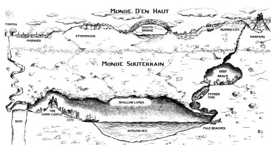
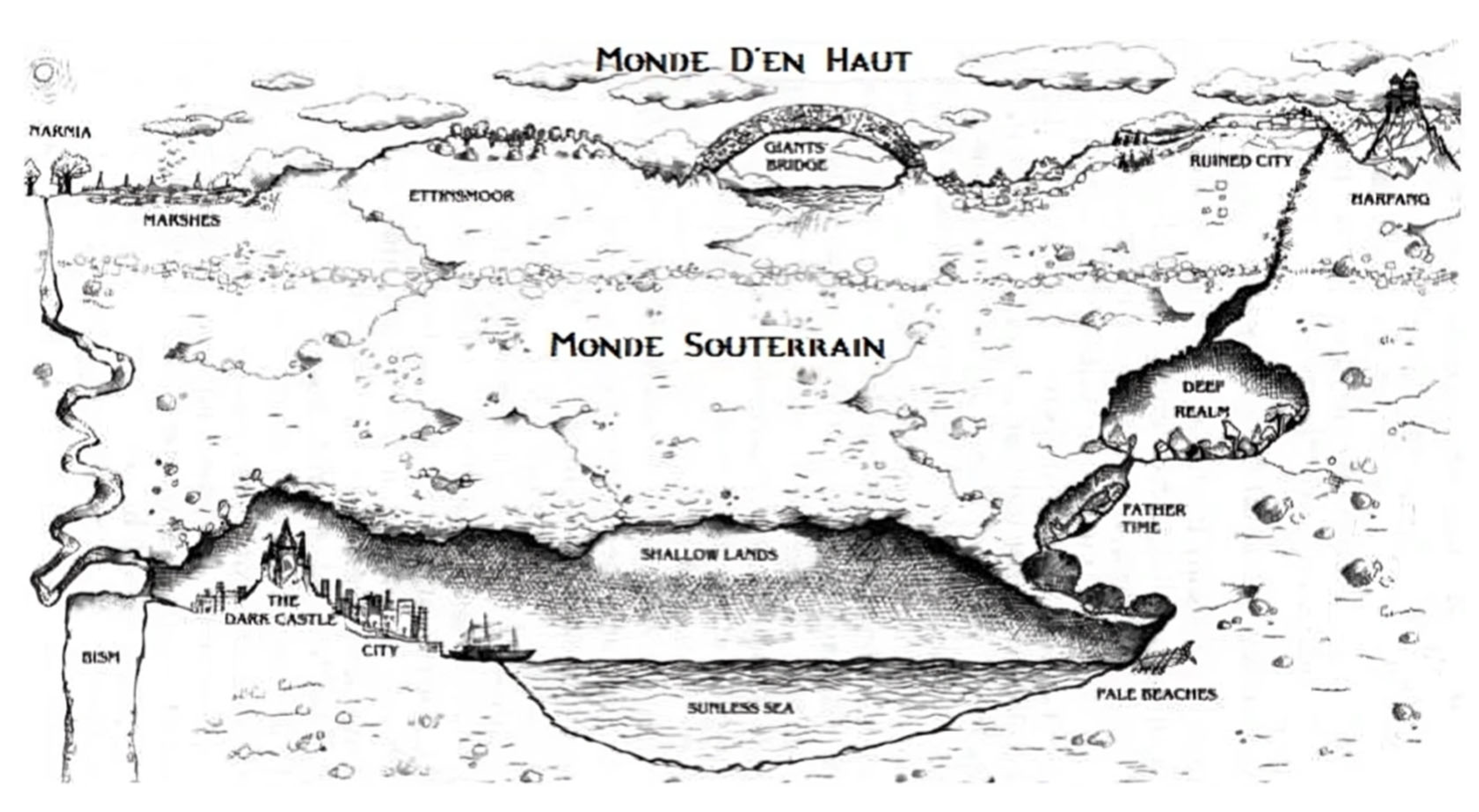
Underground spaces have gradually become recognized as a new category of heritage elements due to their distinctive features. These spaces are carved out of solid material through extractive processes (Figure 1). Designed for a specific purpose compatible with their underground nature, they are often forgotten once their function ceases, thus remaining buried or sealed beneath later structures. They possess high intrinsic heritage value, offering an opportunity to study the traces left by the various civilizations that have inhabited cities. At present, they face a state of vulnerability, as their unique conditions can hardly be compared to those of other heritage assets. These singular features are described below.
Figure 1.
The map to the Under Realm in The Silver Chair. Source: C.S. Lewis’ Narnia series.
- Hidden spaces. Cavities or underground voids from different eras come to light in many historic centers of cities. In most cases, they are unpublished archaeological finds up to that moment, due to the fact that their underground condition has hindered their access and recording. With the evolution and growth of cities, their memory is lost; therefore, all the historical information that contributes to knowing the characteristics of the different eras of the city. The isolation and disconnection from the current above-ground city, along with the difficulty of access, result in most cases in the difficulty of their exploration, limiting the proper patrimonial valuation of the new findings.
- The heritage typology of the underground. The problem intensifies when we try to define the heritage typology to which these underground spaces belong or can be associated. They cannot be classified under the typology of heritage buildings as such, since they are the result of extractive processes, very different from the usual tectonic solutions in architecture. However, neither do they match the characteristics of archaeological sites, as they were conceived a priori as underground spaces—that is, they have not been buried or hidden over time to be revealed through an exhumation action. The lack of consensus regarding the typological definition generates a series of limitations with respect to their protection and management.
- Surfaces of Complex Geometry. The irregularity of their morphology complicates the production of an exhaustive and rigorous graphic representation.Two-dimensional representations are imprecise, as they depend on arbitrary section choices. These spaces are neither flat walls nor tied to axes or specific layouts. This can produce very different results in each case.
- To fully describe this heritage typology, we must use three-dimensional surveys with point clouds. Next, the modeling of complex surfaces is obtained through an optimization process to make them compatible and manageable by most graphics software. This technical complexity results in a lack of clear consensus on the standardization of documentation processes for underground heritage spaces. Existing methods are limited to users with advanced technical skills.
- The difficult legibility and accessibility of the spaces. The problem with these underground spaces is not solely the difficulty in generating the appropriate three-dimensional models. The main issue lies in the spatial reading of these spaces, which are entirely outside the conventional and known. This makes them hard to imagine without prior in-person visitation. However, the limited access to these spaces is another major challenge. Given this extremely adverse situation, it will be necessary to develop interpretive strategies that bring society closer to the qualities and conditions of these hidden spaces.
1.2. Underground Built Heritage (UBH) Patrimonial Typology
The growing attention toward underground spaces has generated the need to define their specific heritage characteristics. First, a brief historical overview of the principal definitions of underground spaces is provided. Before the international classification of Underground Built Heritage (UBH) was consolidated, there were multiple attempts at cataloging based on speleological criteria [1] or functional ones, such as those from the International Union of Speleology [2], as well as UNESCO’s prior recognition of underwater cultural heritage [3]. Although this does not represent the same type of heritage, it shares certain aspects in common, particularly the need to protect spaces that are hidden or difficult to access. These approaches distinguished types and original uses of artificial cavities but did not incorporate the heritage dimension or the historical transformation processes described in reviews on the subject [4], leaving these spaces without effective protection tools.
In response to this gap, the theoretical definition of UBH emerged [5]. As defined by the authors:
The Underground Built Heritage (UBH) class, introduced at a methodological and theoretical level in 2021, collects cultural assets excavated throughout history from underground that, today, are significant elements of local cultural heritage, having strongly impacted on the “sense of place” of local communities. Those cultural assets have been at the core of several national and international regeneration processes, and, recently, new tools have been developed to support their classification and sustainable reuses [6].
At present, this constitutes the most widely accepted classification within the scientific community for defining underground heritage spaces, integrating criteria related to spatial position, artificiality, and cultural significance—both tangible and intangible—while also proposing methodological strategies for their adaptive reuse. As stated in the definition of the UBH class, it is important to emphasize that processes of interpretation and valorization are strongly rooted in community participation [7,8], participatory governance [9], and the social dimension of heritage [10]. In this context, local communities play a crucial role in the interpretation, stewardship, meaning-making, and long-term sustainability of heritage sites. Parallelly, the field has advanced through the development of 3D documentation methods based on laser scanning [11,12], photogrammetry [13,14], or hybrid techniques [15,16,17], as well as studies on visualization and physical models [18,19]. Likewise, research projects such as Underground Space for Territories Knowledge and Enhancement [20] by the Italian CNR, along with other approaches to the issue like those by Francesco Venezia [21] or Grottes Ornées [22], together with research on Matera [23,24,25,26] and the CHRIMA project [27], have demonstrated the potential of underground heritage in urban understanding, rock conservation, and the application of graphic and multidisciplinary methodologies. These initiatives have advanced conservation strategies through the application of different dating technologies and three-dimensional descriptive methods, while also proposing approaches for the valorization and dissemination of this heritage.
The Underground4value project [28,29] represents the most recent advancement in promoting a sustainable methodology for the conservation and reuse of UBH. It brings together disciplines such as archaeology, geotechnics, architecture, tourism, and sustainable development. Its results include three knowledge platforms: the E-Learning Platform (Training Schools), the U4V Platform for inventorying and dissemination, and the U4V Toolbox for methodologies and best practices. The project has also produced specific monographs [30,31] that describe the project’s actions and compile various UBH case studies.
This research addresses the existing gap related to the lack of standardized and specific protocols for the conservation and valorization of UBH. As a novel contribution, it proposes a methodology structured through several stages. The approach goes beyond mere three-dimensional documentation by combining a series of actions that, although previously developed, have largely been explored as isolated research efforts and have not yet been integrated into a unified methodological framework. In addition to documentation, the distinctive aspect of this research lies in the incorporation of interpretation as a means of understanding UBH. This perspective has not previously been associated with documentation processes of specific underground case studies. At a more specific level, the study proposes a set of innovative methods applied and adapted specifically to UBH, such as ontological integration, geometric simplification of complex surfaces, and visualization strategies based on interpretative graphic models.
1.3. Research Aim
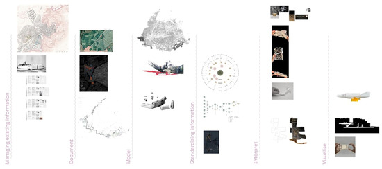
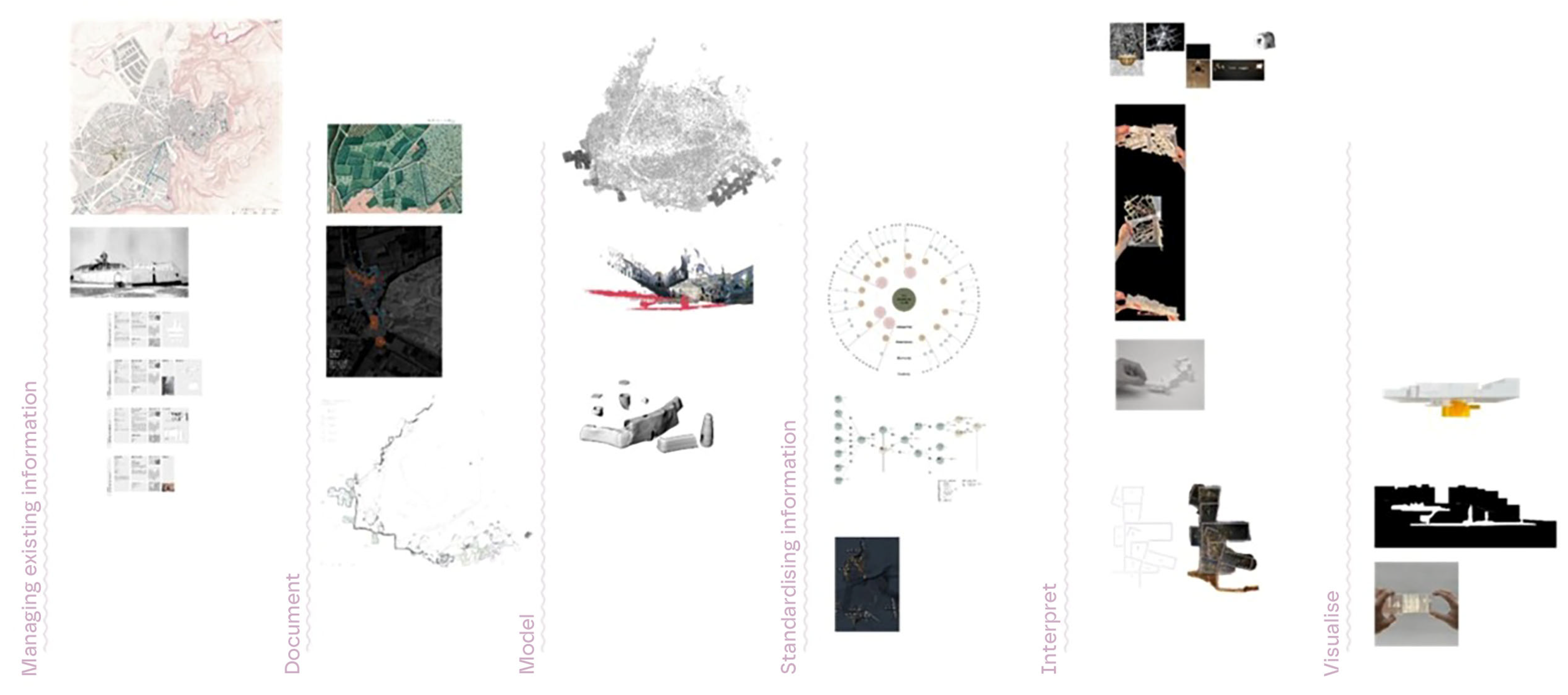
This research aims to explore strategies and protocols that favor the enhancement and conservation of the heritage typology. To this end, a specific methodology will be proposed that integrates the different phases of exploration, documentation, analysis, interpretation, and enhancement, leading us to define a series of specific objectives applied to a case study (Figure 2):
Figure 2.
Graphic summary of actions carried out for each objective.
- Managing existing information. One of the aims of this research is to collect, organize, and systematize the existing information on the set of underground spaces in Carmona. This is achieved through resources that allow recognizing the existing findings and, at the same time, house all the information in a common repository.
- Document. The unique geometry of these spaces requires careful planning for documentation and surveying campaigns. Plans must match the heritage typology and its limitations, while coordinating with prospecting and recording processes. The objective of this work is to propose various documentation alternatives depending on the required level of detail and the conditions and dimensions of the spaces under study. Workflows will be defined based on point cloud documentation techniques.
- Model. Performing three-dimensional modeling of objects with complex geometry is not always straightforward; first, due to the lack of orthogonality, and second, because surfaces generated from point clouds—depending on the software used—produce excessively complex meshes that poorly reflect the real geometry of the walls, making them unsuitable for export to other software. For this reason, a specific protocol will be created to geometrically simplify these surfaces and enable their import and export in the most commonly used 3D modeling software for information. One of the objectives will be to ensure interoperability and geometric compatibility, facilitating the exchange of heritage information and improving workflows among the various stakeholders.
- Standardizing information. The lack of consensus regarding heritage typology makes the existing information on underground heritage elements highly disparate. This discrepancy stems from the use of different criteria when conducting exploration and documentation. This research aims to create a specific categorization and standardization of heritage information fields for the UBH class. This will serve as a basis for future findings, improving the legibility of heritage information, and enabling comparisons between different case studies of the same typology. This standardization is based on cultural heritage data ontologies such as CIDOC-CRM.
- Interpret. Underground spaces present an additional difficulty compared to other heritage spaces resulting from an architectural project, due to their own extractive nature, which is largely organic. This circumstance requires parameters that explain how they are perceived, constructed, and inhabited. One of the objectives of this research is to create a sensory narrative based on examples that reflect on different concepts of inhabiting and perceiving the underground world. From this sensory narrative, interpretive models will be proposed that enable understanding the complexity and uniqueness of this typology.
- Visualize. Understanding the spatiality of places with irregular geometries, such as underground spaces, is truly complex without having visited them, which rarely proves easy. The proposal for specific visualization strategies for this type of space gains particular relevance. For this reason, a graphic representation project is developed, specific and tailored to the heritage typology, enabling both the general public and researchers to adequately perceive and describe all the spaces. This approach is supported by frameworks and guidelines promoted by international organizations such as UNESCO, the Council of Europe (CoE), and ICOMOS, which emphasize the importance of community participation in the interpretation, care, meaning-making processes, and long-term sustainability of heritage sites.
2. Materials and Methods
Methodology
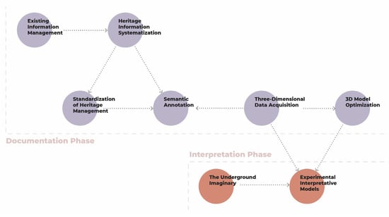
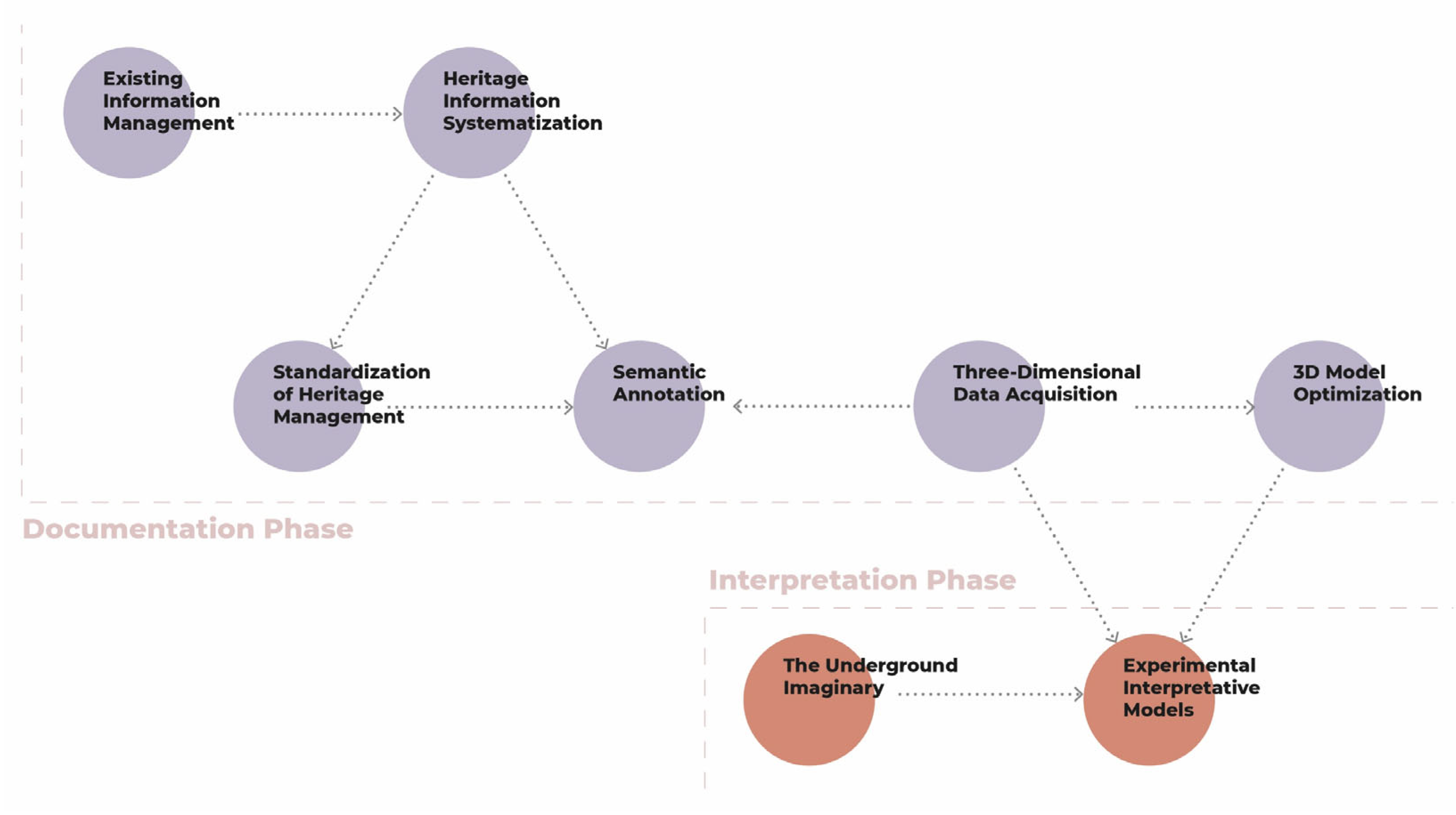
The nature of this research is eminently methodological. From this approach, experimental protocols are defined that seek to address the current limitations in the management of underground heritage spaces. This methodology is subordinated to the previously established objectives, with a workflow defined in phases (Figure 3):
Figure 3.
Diagram of the experimental methodology proposed for the documentation and interpretation of UBH.
- 1.
- Documentary phase. This phase encompasses both the management of existing information and new data captures and three-dimensional modeling.
- The management of existing information is divided into two types of actions:Initially, a protocol is created for detecting heritage information linked to Carmona’s underground heritage spaces, establishing primary sources for searching cartographic, historical, or archaeological documentation.A specific data structure is created, adapted to the typological uniqueness and specifically designed for underground heritage spaces. It consists of various stages, from creating a specific database or graphic standardization of existing graphic media, accompanied by allusive texts from consulted archives and documents, visualizations of metric captures, etc.
- The data capture and modeling actions are divided into the following two specific actions:Data capture using point clouds requires specific knowledge of the various existing techniques. It also demands thorough prior planning, which largely depends on the nature of the elements that are to be documented, external conditions, available resources, and the documentation technique to be employed.Modeling this type of space—formed by surfaces with complex geometry—requires a simplification process and proper information exchange between the different modeling elaboration stages.The actions described above are established in standardized protocols based on the CIDOC-CRM data ontology.
- 2.
- Interpretive phase. An analytical process that combines the analysis of bibliographic, artistic, and graphic references with the new heritage data generated in this research, formulating strategies that enhance the understanding and interpretation of the heritage asset.This phase has been designed to have a high imaginative component. The interpretive process requires describing concepts and ways of inhabiting and conceiving underground spaces, in order to subsequently propose a series of models that allow interpreting the heritage asset. This approach is termed “graphic project” and focuses on designing the complete and detailed visualization of underground heritage spaces.
All these processes stem from a multidisciplinary positioning where each has a diverse nature, derived from distinct disciplines such as geometry, architectural analysis, archaeology, or history, each focused on the specific issues arising in the actions or phases structuring the research.
3. Results
Starting from the described methodological framework applied to various case studies, a series of results is developed following the same phase structure and workflow outlined.
3.1. Documentation and Modeling
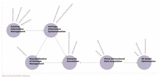
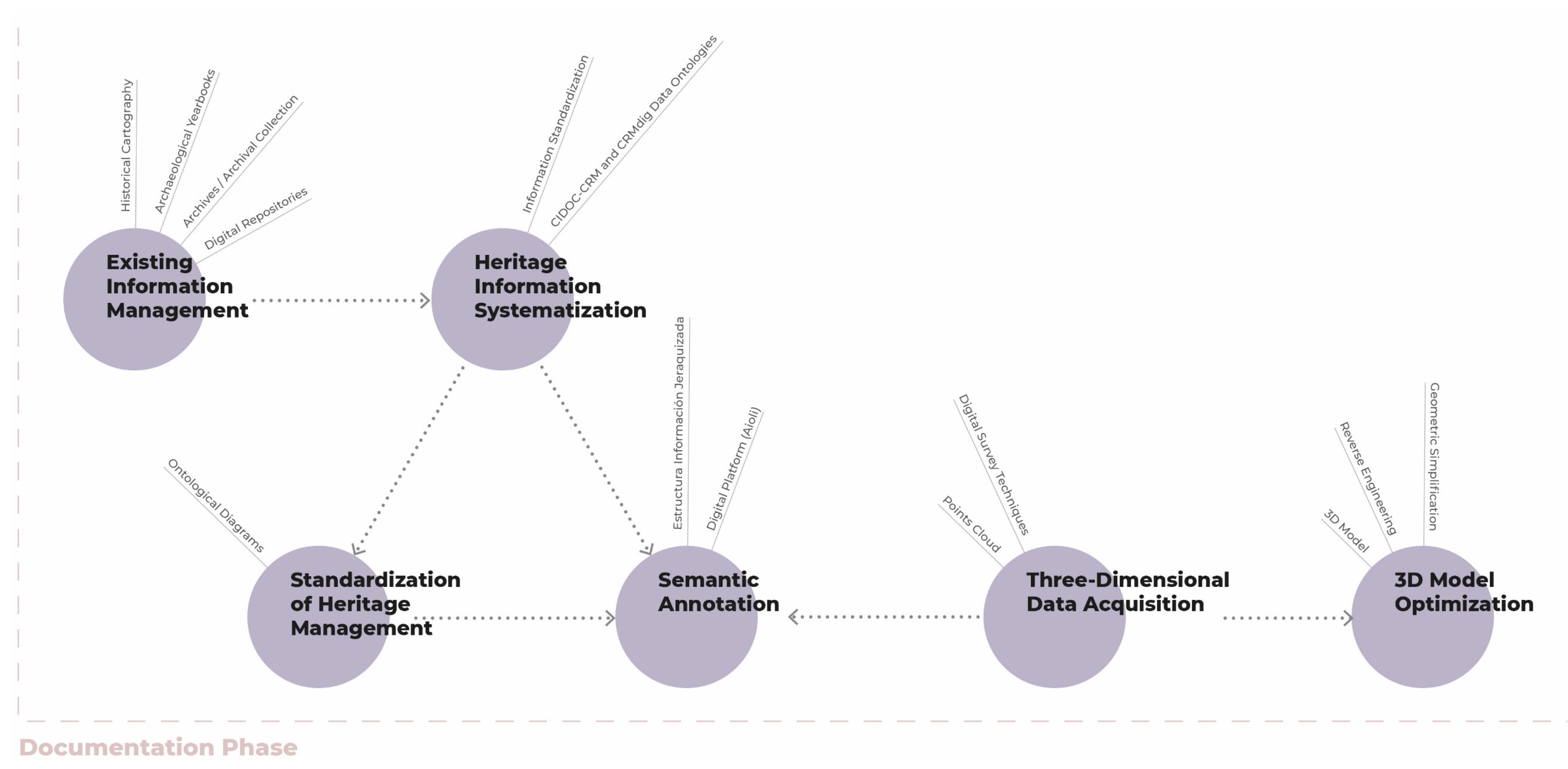
In this first phase, poor documentation of excavated heritage and a lack of agreement on processes have been found. Therefore, a series of actions is proposed to advance knowledge of this unique heritage type. These will create workflows for agreed documentation and standardized information, as much as possible. (Figure 4).
Figure 4.
Methodological diagram of the documentary phase.
3.1.1. Management and Analysis of Existing Heritage Information
This step in the documentary phase involves compiling, organizing, and evaluating prior records on UBH sites. It addresses documentation shortcomings by integrating diverse sources like historical archives and surveys to standardize data for subsequent modeling and interpretation.
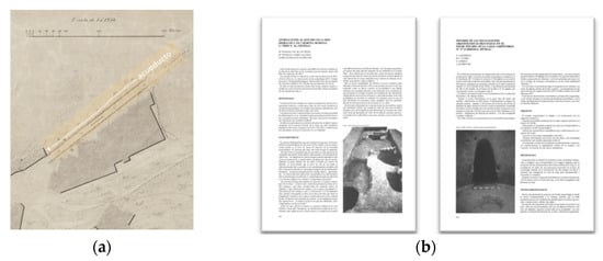
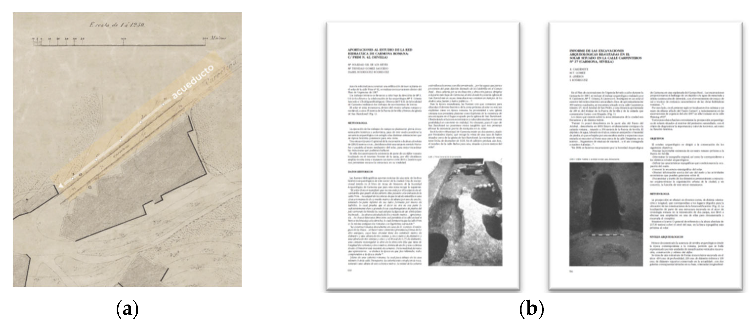
Historical cartography analysis allows examining the territory’s importance in the city’s evolution, growth, and impact on underground spaces (Figure 5a).
Figure 5.
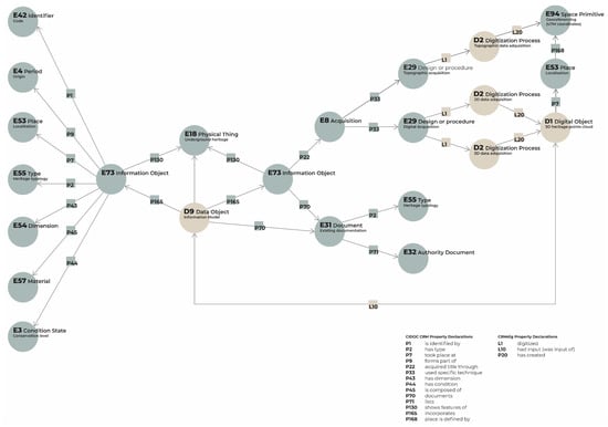
(a) Fragment of the military plan of the city of Carmona (Spain), 1868. (b) Examples of pages from the Archaeological Yearbook of Andalusia.
Due to their subterranean nature, it is necessary to rely on archaeological records to find information on these heritage elements, as they become hidden again under the surface of the city after excavations (Figure 5b).
3.1.2. Systematization of Heritage Information
For the systematization of heritage information, a lack of consensus in information fields and descriptors used across studies has been identified first. This variability hinders objective comparisons between similar patrimonial assets, complicating multidisciplinary analysis and management despite shared typologies. The absence of standardized frameworks obstructs coherent, comparable databases. Thus, unified protocols are essential to standardize documentation, enabling better comparison, analysis, and decision-making in cultural heritage management, and enhanced efficiency in research, conservation, and dissemination through cross-disciplinary collaboration.
Therefore, this phase seeks to create a specific information structure for UBH that facilitates documentation of future patrimonial findings and standardizes obtained data through data ontologies. Data ontologies are based on defining relationships within a network or data system, with a specific ontology existing for each knowledge domain or area.
The reference ontology for exchanging cultural heritage information is the CIDOC Conceptual Reference Model (CRM), outlined in ISO 21127:2014 [32]. CIDOC-CRM is widely used in cultural heritage ontology diagrams, enabling extensible semantic adaptations with complementary ontologies [33]. Here, it pairs with the CRMdig extension for patrimonial digitization.
Building on analysis of ontology diagrams from prior studies [34,35,36,37,38,39,40,41,42,43] and UBH typological specifics, a data structure is created based on CIDOC-CRM [44] and CRMdig [45].
This initial patrimonial information structure comprises distinct levels: a top level of general categories grouping site descriptions, followed by subcategories as descriptors for advanced classification and precise identification (Table 1).
Table 1.
Information structure: categories, descriptors, and information entities.
The generated database proposes concrete information levels with typology-specific coding to aid stakeholder readability, forming a branched (tree-like) data structure for easy heritage tracking—developed for caves but extensible to other subterranean types.
3.1.3. Standardization of Information Management Processes and 3D Documentation Based on Data Ontology
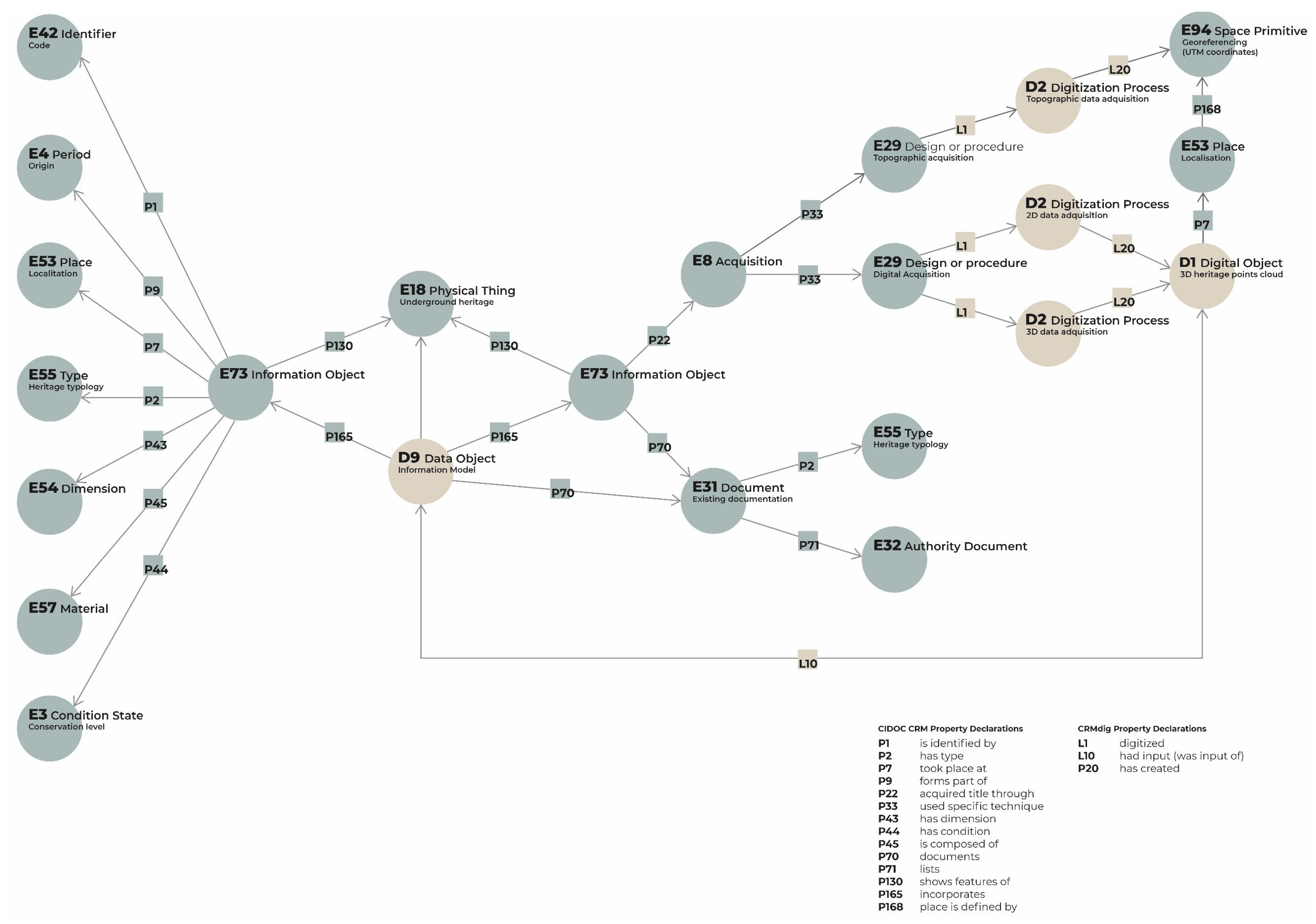
The next work phase aims to standardize data via custom ontological diagrams based on UBH-adapted data ontologies (Figure 6). These describe standardized documentation processes to simplify data capture in future patrimonial discoveries and boost information readability.
Figure 6.
Example of a developed ontological diagram, here to standardize subterranean patrimonial space documentation processes.
For proper management, 3 levels of data ontology are proposed [46], corresponding to distinct heritage management processes via CIDOC-CRM and CRMdig codes:
- Standardize documentation processes for subterranean patrimonial spaces
- Standardize data capture and information model generation processes for subterranean patrimonial spaces
- Standardize alphanumeric data annotation on 3D models.
The ontologies proposed below describe specific processes for documenting subterranean patrimonial spaces. They adapt existing ontological diagrams selectively, either for similar documentation methods or studies on the same heritage typology.
3.1.4. 3D Data Capture Process
Subterranean spaces feature complex and irregular geometry, making it impossible to use conventional 2D architectural survey methods for graphical documentation of these patrimonial spaces.
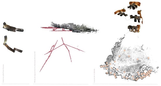
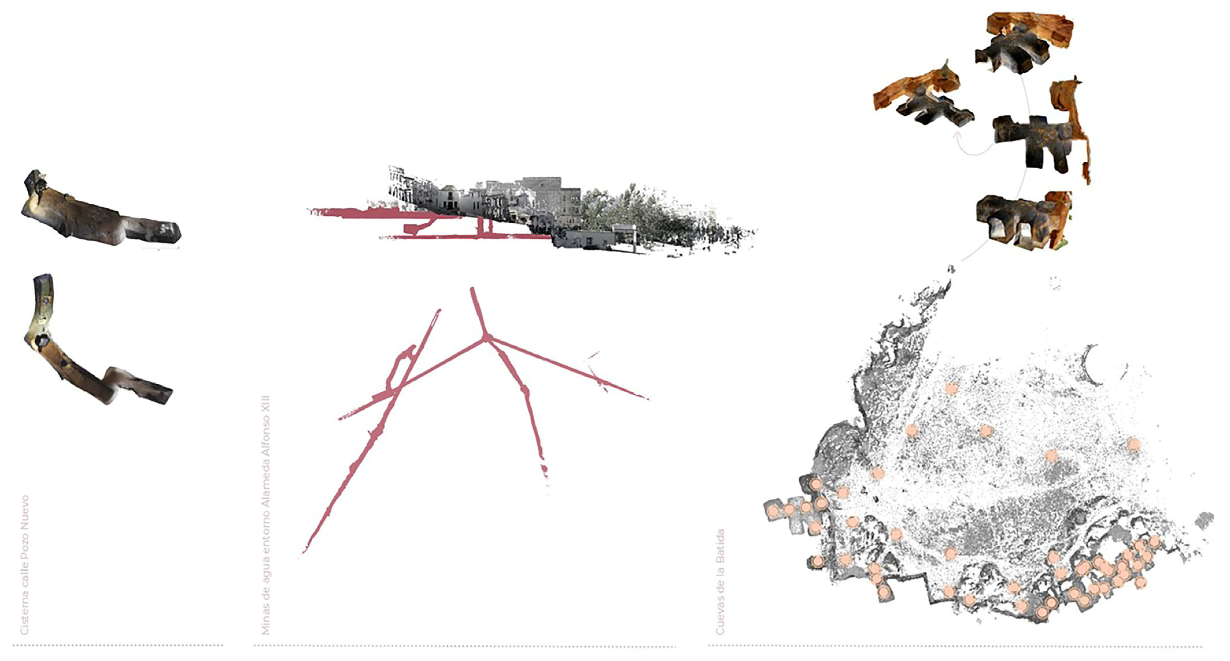
Drawing from existing 3D data capture research [47,48,49] and techniques like photogrammetry or laser scanning, plus studies on subterranean challenges —complex surface geometry [50], submerged surfaces [51], or georeferencing [52]—specific documentation strategies are proposed based on typology, scale, and purpose, employing varied 3D survey methods (Figure 7). Summarized in the following table (Table 2):
Figure 7.
Examples of 3D data captures from various case studies of Carmona’s (Spain) subterranean structures complex, following the proposed workflow.
Table 2.
Three-dimensional data acquisition techniques adapted to the morphological typology of the heritage asset and to the specific objectives of its documentation.
3.1.5. Semantic Annotation of Patrimonial Data on 3D Models
This research phase arises from the need to manage information for preventive conservation of subterranean spaces via data linked to extractive-constructive traces or identifiable pathologies on covering surfaces.
A typology-adapted methodology enables alphanumeric patrimonial annotation on point cloud 3D models using web applications.
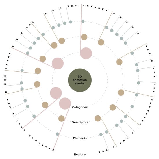
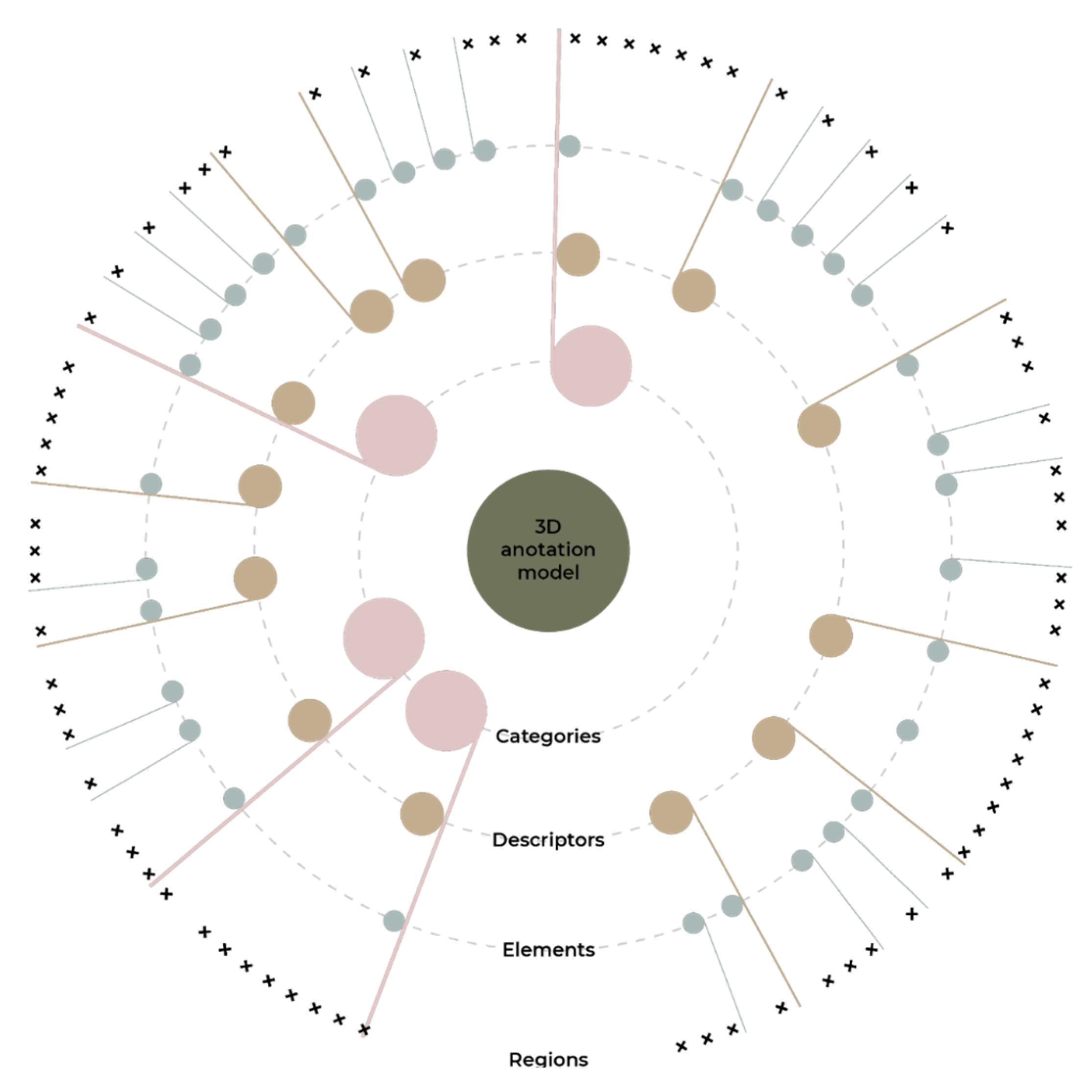
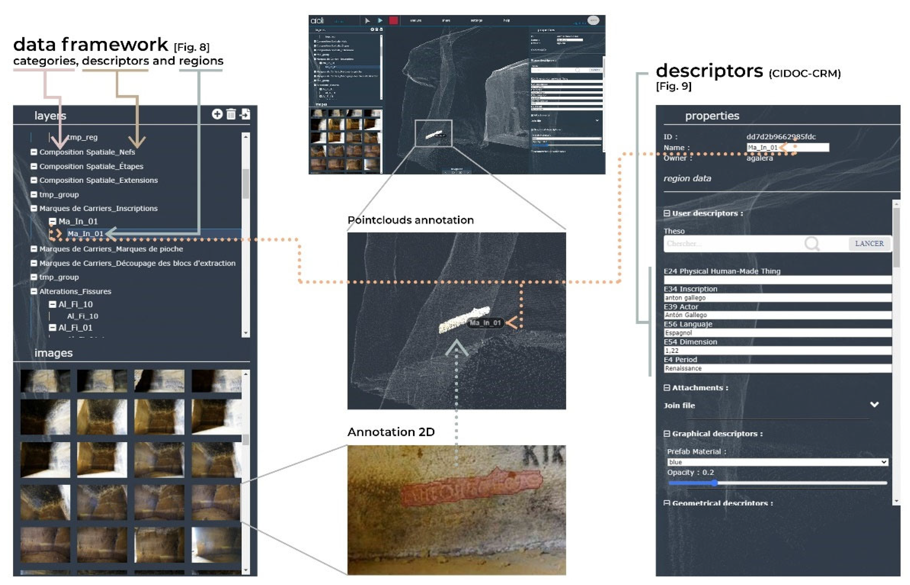
To ensure standardized, continuous processes, it employs a hierarchical information structure: Categories, Descriptors, highlighted elements, and marked regions (Figure 8).
Figure 8.
Diagram of the hierarchical data structure for distinct annotation model information levels. Pink highlights the most generic level (categories), yellow the descriptors level, blue the elements, and crosses mark polygonal regions drawn on the model. This visualizes multi-tier semantic tagging on 3D point clouds for UBH conservation monitoring.
Once the specific information structure for subterranean patrimonial spaces is designed, the focus shifts to visualizing this buried typology using the Aïoli 3D annotation platform from France’s CNRS MAP lab. Aïoli supports semantically enriched descriptions from photogrammetric reconstruction and spatial labeling, linking image-based modeling, 2D/3D dissemination, and multi-layer semantic annotations [53,54]. The web app processes prior cave point clouds, positions/orients source images for subsequent data annotation (Figure 9).
Figure 9.
Aïoli® collaborative web platform workflow for patrimonial data annotation, following Figure 8’s information structure and Section 3.1.2 descriptors (Table 1).
3.1.6. Optimization of 3D Models for Complex Geometry Surfaces from Point Clouds
3D modeling from point clouds produces complications and inaccuracies, as noted in prior studies [55,56], yielding models with overly complex, polygonated, striated surfaces or holes—never fully closed, with excessive error rates. This hinders use for documentation and conservation tasks, necessitating optimization.
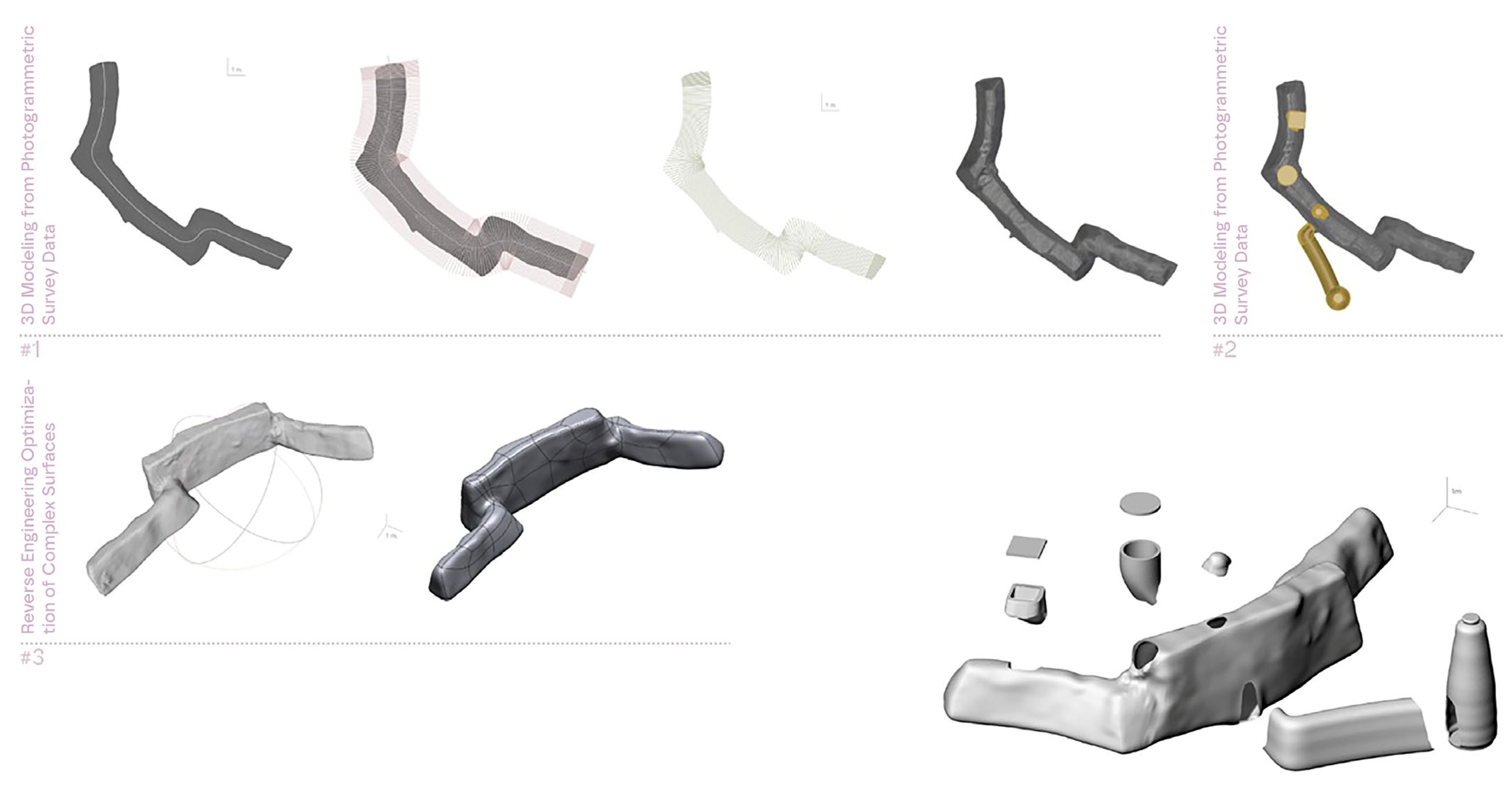
The proposed experimental process starts with point cloud-based 3D modeling, applying reverse engineering and geometric simplification for interoperability across modeling and heritage management software. This enables disassembling individual patrimonial elements for import into BIM (Building Information Modeling) programs.
Workflow structured in three phases [57]: First phase of 3D modeling from a collection of sections made on the mesh resulting from the point cloud. Second phase of modeling from previously existing information on elements not sufficiently defined by the point cloud. In addition, a third phase of surface optimization involves reverse engineering strategies. With this process, an optimized 3D model of the patrimonial element is achieved (Figure 10).
Figure 10.
Workflow for optimizing complex geometry 3D models.
3.2. Interpretation and Visualization
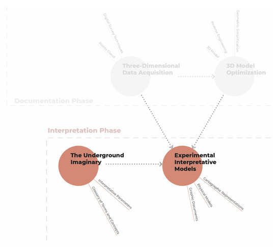
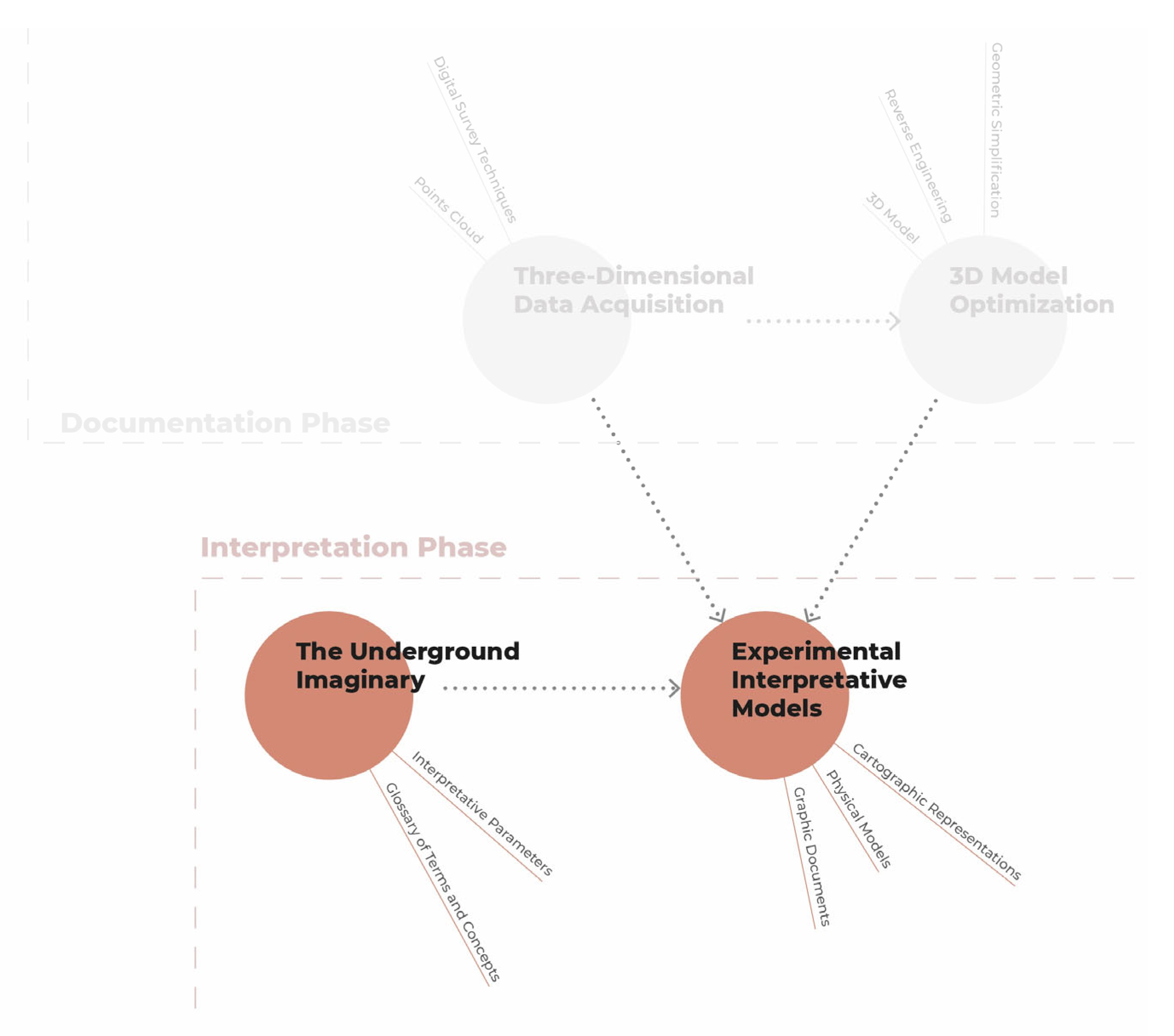
The subterranean world exhibits unique spatial and typological traits, posing specific interpretive challenges unlike surface heritage—hard to envision without interior access. Limited entry due to burial underground necessitates reflective processes on interpretation and inhabitation conditions, both conceptually and via interpretive models complementing descriptive documentation for immersive comprehension of UBH spaces (Figure 11).
Figure 11.
Methodological diagram of the interpretation phase.
3.2.1. The Subterranean Imaginary: Interpretive Parameters
Subterranean spaces, are difficult to visualize and comprehend; this issue has already been addressed by architects, urbanists, artists, historians…, such as Dominique Perrault with his Groundscape theory [58], Edouard Utudjian with his approaches to Architecture et urbanisme souterrains [59], Bernard Rudofsky in his book Architecture without architects [60], or Eduardo Chillida [61], among many others. To contextualize the research, several concepts used to describe and interpret subterranean reality are examined. The aim is to go beyond the concrete and enrich the study through references that move away from purely denotative aspects to explore the world of indirect relations—often unintended—of creation, imagination, the dream realm, and more personal, even poetic interpretations that use the subterranean as a lever for creation or planning.
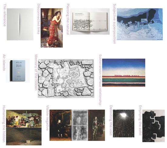
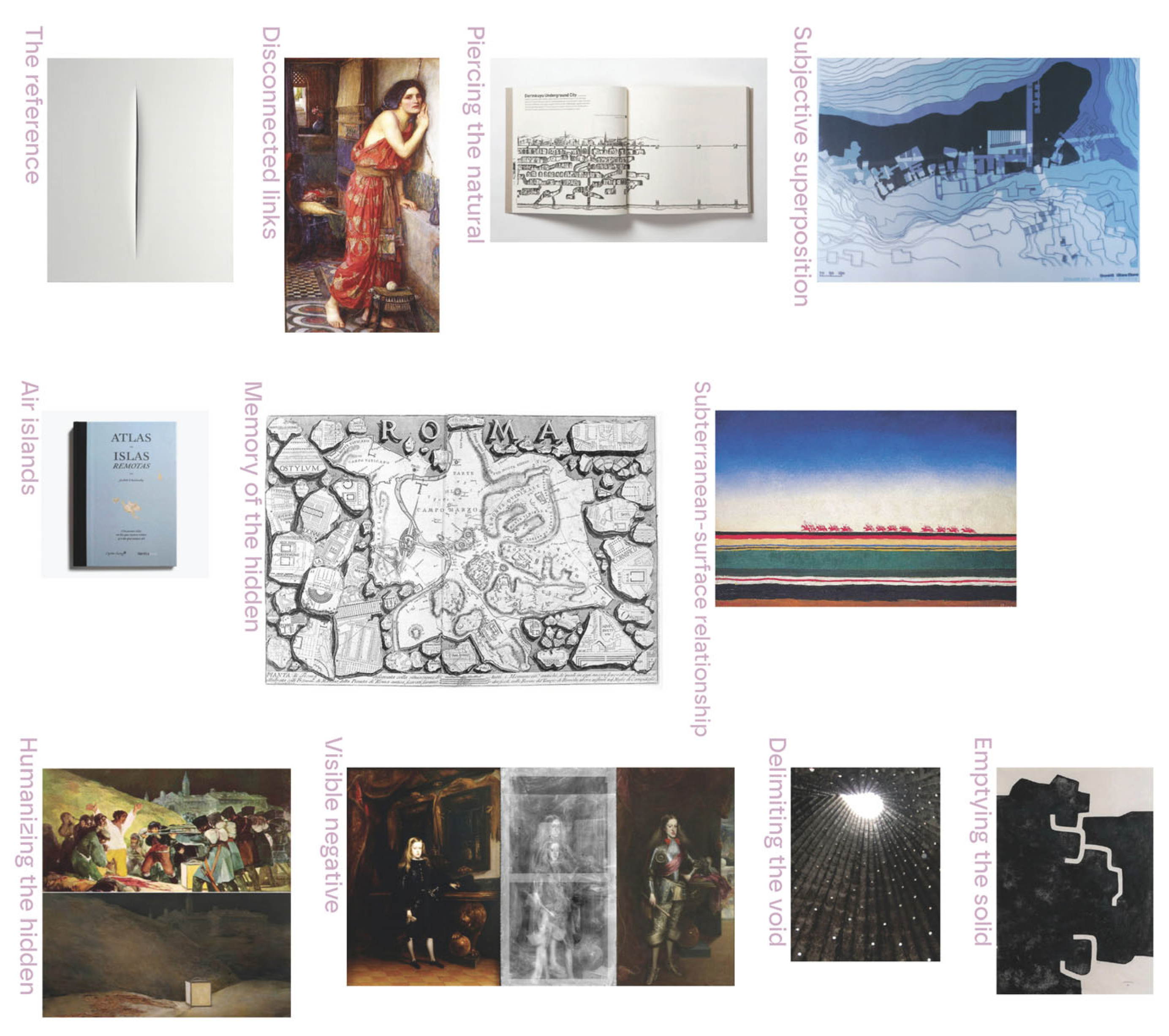
Applied to subterranean spaces through architecture, photographs, books, exhibitions, ephemeral installations, paintings, historical events, engravings, molecular analyses, urban and heritage studies, the following concepts and themes are proposed: Piercing the natural; The reference; Disconnected links; Subjective superposition; Memory of the hidden; Air islands; Humanizing the hidden; Full/empty, hidden/visible, darkness/light, negative/positive; Visible negative; Emptying the solid; Delimiting the void; Dissolving the boundary; and Subterranean-surface relationship. This is a collection (Figure 12) of highly subjective themes—deemed relevant, but which form a visually interpretable catalog—allowing each viewer their own autonomous evocation of imagination, without the need to narrate links between concepts and associated graphic references.
Figure 12.
(From left to right and top to bottom) Fontana, L. (1960). Concetto spaziale. Attesa. Waterhouse, J. W. (1909). Thisbe. Bowkett, S. (2017). Reinterpretation of the section of the underground city of Derinkuyu. Plan of the underground city of Cappadocia. Schalansky, J. (2013). Atlas of Remote Islands. Piranesi (1756). Plan of marble from Ancient Rome. Malevich, K. (1932). Taking of the Red Cavalry. Ballester, J. M. (2007). Hidden Spaces. Comparative study of Francisco de Goya’s original painting, 3rd of May, and the dehumanized version. X-ray of the portrait painted by Juan Carreño de Miranda of King Charles II, 1681. Zumthor, P. (2007). Bruder Klaus Chapel, Germany. Chillida, E. (1981). Grabado Hildokatu.
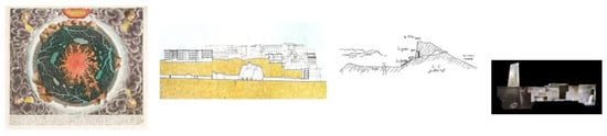
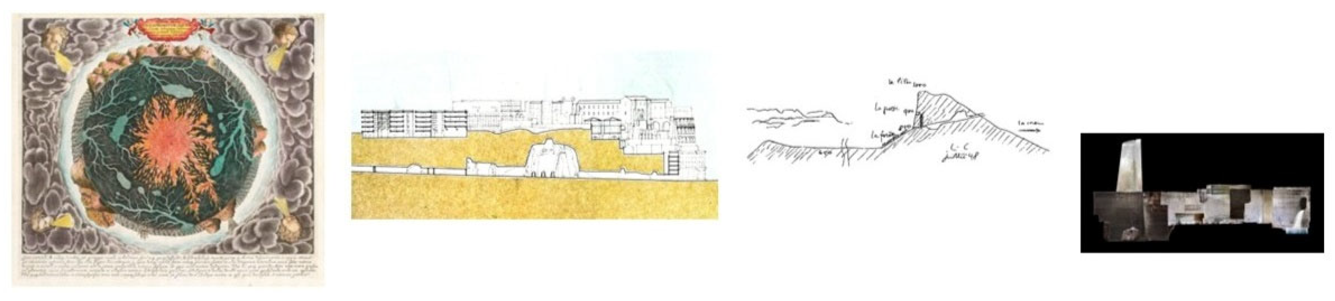
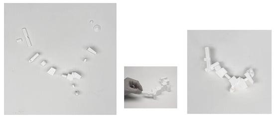
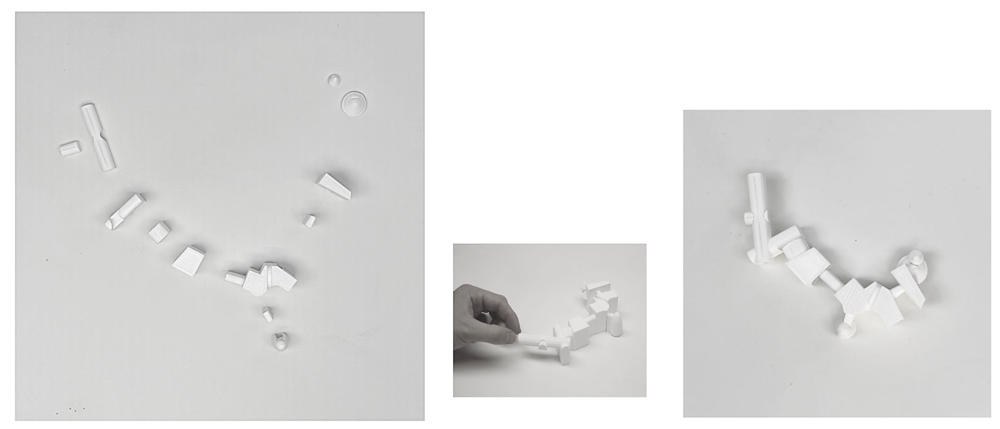
When delving into the last concept—the subterranean-surface relationship—understanding underground spaces requires exploring potential exterior links. Thus, interpretation is pursued through graphic analysis of sectional views, seen as the transition between the surface city known to all and the parallel subterranean city, mostly unknown and hidden. These are examined across various contexts (Figure 13) in the historical cartographies, reuse strategies, heritage spaces, or the projective conception of underground areas. These connection points represent key opportunities for valuing, disseminating, and conserving subterranean heritage.
Figure 13.
Graphic sectional representation has been used by various authors throughout history to depict underground spaces, from Athanasius Kircher’s 1668 cross-section of the Earth in Mundus Subterraneus [62]. Francesco Venezia’s description of Naples’ underground [63]. Project ideation for excavated designs like Le Corbusier’s Basilica of Sainte-Baume [64], or Ensemble Studio’s use of 3D survey techniques for subterranean heritage intervention and rehabilitation projects [65].
Through these graphic and sensory experiences, we have seen how the city’s ground line has ceased to be a continuous limit and thus becomes permeable, where hidden voids turn into integrated and usable spaces in the above-ground city. Moreover, linking subterranean spaces with the surface level city adds a stereotomic, three-dimensional feel to its base, surpassing the habitual bidimensional plane. Connection points between both generate opportunities for integrating subterranean spaces into the contemporary city.
The proposed descriptive parameters subsequently enable the definition of a set of specific actions aimed at enhancing the description and understanding of underground spaces through the development of interpretative models.
3.2.2. Experimental Interpretive Models
The final step in the proposed workflow involves developing experimental interpretive models. These enable detailed descriptions that enhance perception of heritage subterranean spaces, making them more legible and accessible to non-specialist general audiences. This approach promotes public dissemination and valuation of such sites.
These experimental actions extend beyond mere 3D documentation. They hybridize graphic and plastic mediums, virtual-digital technologies with analog-material objects and models, forming a collection of representations linked by a methodological thread that crafts a cohesive graphic narrative. Each experimental graphic action [66] focuses on a specific theme, as described next.
- Geometric interpretation of complex excavated spaces
Material extraction creates complex, irregular underground geometries hard to depict in 2D and sometimes even 3D due to overlapping excavations. Physical models improve legibility via morphological simplification using inverse techniques: solidifying voids while leaving the containing earth undefined. Precedents include Church of S. Maria della Divina Providenza in Lisbon [67] and Seville Cathedral [68]; assembled pieces reveal full excavated volume (Figure 14).
Figure 14.
Physical Interpretive Model: Palombaro Lungo Geometry, Matera (Italy).
- Extraction Process Logic
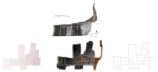
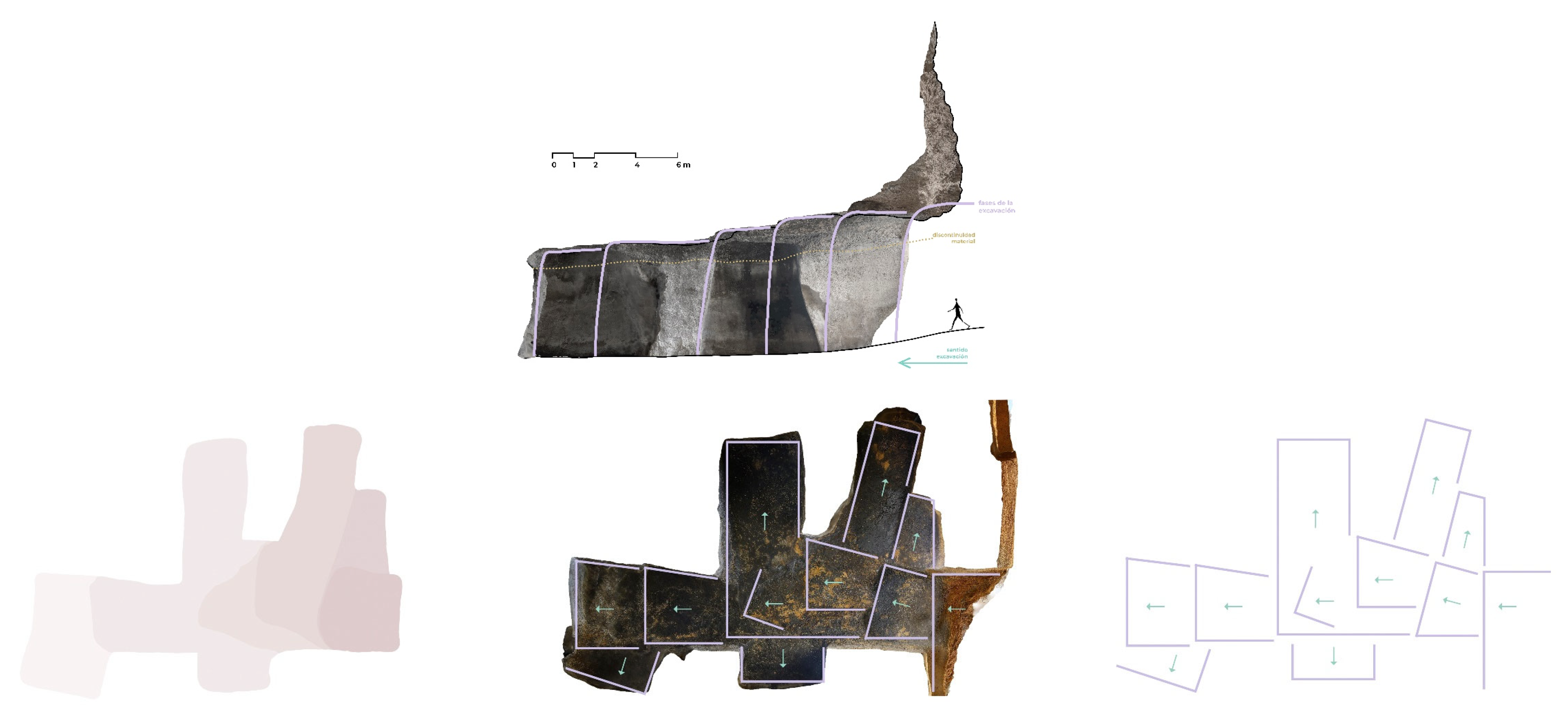
Extraction processes in subterranean spaces are not always obvious, particularly in large-scale ones. Geometric analysis and reading of horizontal/vertical walls clarify excavation phases, chronology, height differences, and directions (Figure 15). These irregularities identify distinct phases and approximate extracted material volume [69].
Figure 15.
Geometric and spatial analysis in mirrored sections and plans determines excavation phases of Batida Caves in Carmona, Spain.
- Tactile Reading of covering surfaces
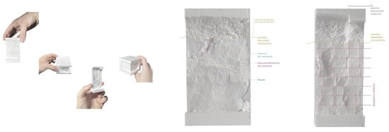
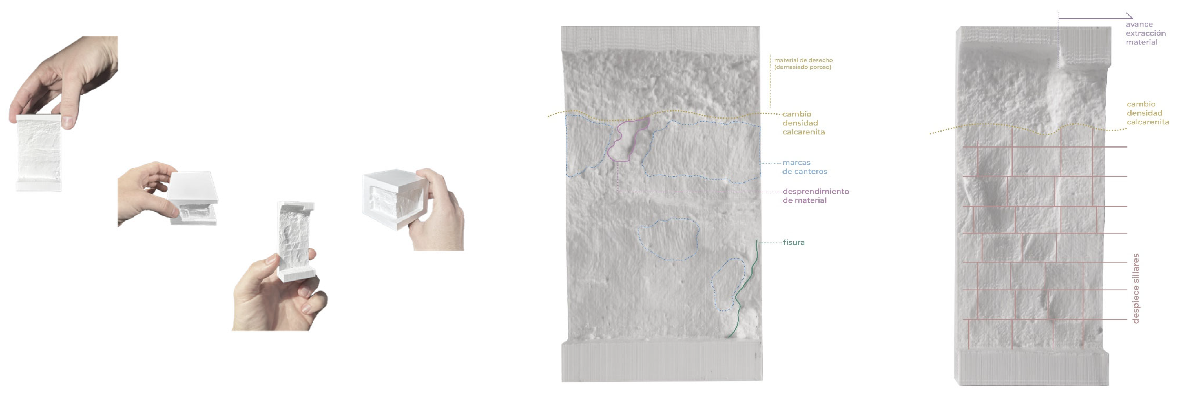
Neutral graphic models without textures or colors highlight high-resolution surface irregularities on walls. They detect extraction joints, ashlars, patinas, mortars, excavation marks, mason signs, and fissure details invisible to the naked eye. These information fields also correspond to those previously established in Section 3.1.2 for information standardization, and the detected areas have been incorporated into the semantic annotation described in Section 3.1.5. For this analysis, several models are generated from high-resolution point clouds and produced through 3D printing at different scales (Figure 16). In addition to improving visualization, these objects allow tactile exploration of the existing surface textures. These physical artefacts enhance the legibility of heritage information and encourage broader public engagement in the understanding of cultural heritage. In this context, local communities play a crucial role in the interpretation, stewardship, meaning-making, and long-term sustainability of heritage sites.
Figure 16.
3D-printed pieces at varying scales and detail levels reveal heritage data from Batida Cave in Carmona (Spain).
- Subterranean-Surface Relations. Links and Overlaps
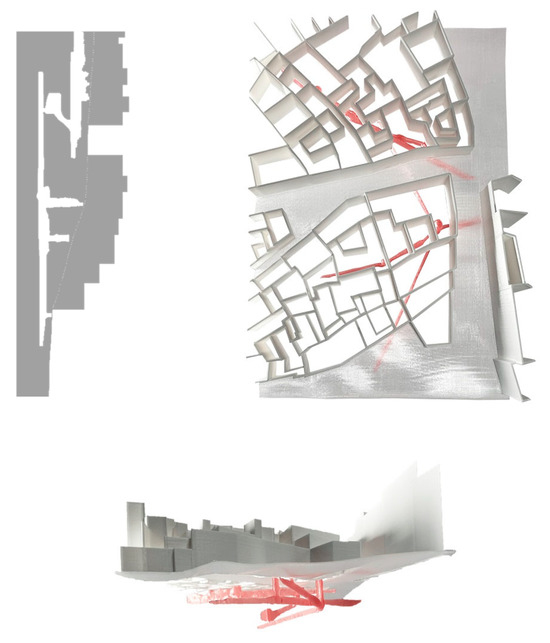
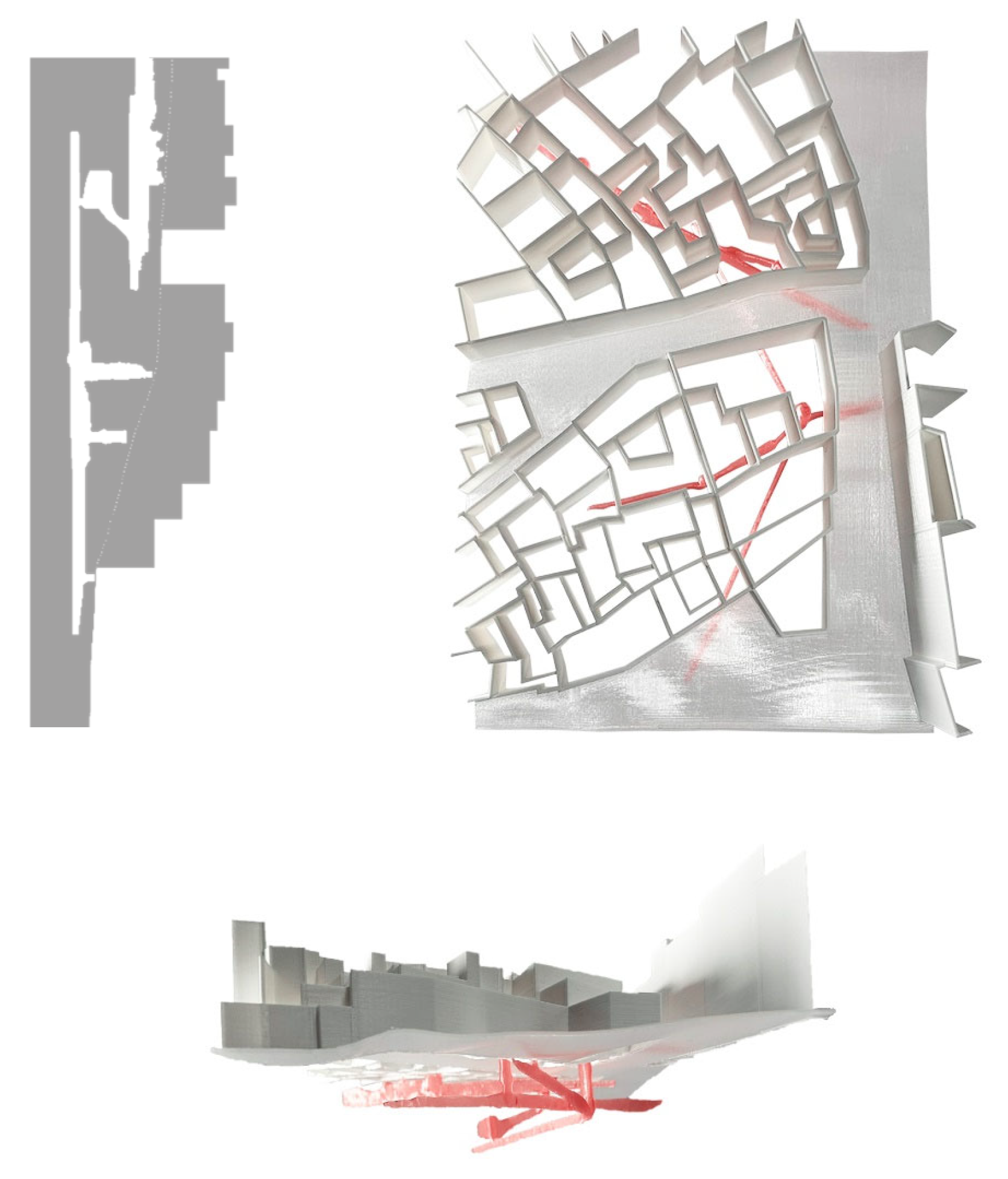
As previously outlined, one key challenge for heritage subterranean spaces involves both physical access and their vital connections to the surface city above. While smaller, discrete patrimonial elements prove relatively easy to pinpoint through obvious entry points, extensive linear structures like water supply networks pose greater difficulties—few points along their paths can be reliably measured, and their frequent subtle bends further hinder accurate tracing and mapping. The solution employs detailed 3D point cloud surveys of underground features, georeferenced to surface models via at least two shared control points between datasets, yielding comprehensive trajectory visualizations. Additionally, physical 3D-printed models enhance understanding by prominently displaying subterranean voids while representing above-ground buildings as simplified wireframes—showing only vertical walls and omitting all horizontal planes like roofs and floors—to reveal hidden heritage elements beneath the urban fabric (Figure 17).
Figure 17.
Physical interpretive model made via digital fabrication techniques: plan view (right), front view (bottom), 2D section/elements/niveaus (left)—Water Mines around Alameda Alfonso XII, Carmona, Spain.
These visualization and interpretation strategies extend to other subterranean heritage typologies and case studies with minor adjustments. They initiate a catalog of graphic descriptions for UBH patrimonial typology concepts.
This multidisciplinary methodology enhances description, dissemination, and valuation of subterranean heritage spaces.
4. Discussion
The results confirm that traditional approaches focused solely on Euclidean coordinate-based geometric documentation are insufficient for a comprehensive understanding of UBH. Although 3D surveying techniques like point clouds, photogrammetry, or hybrids precisely record complex geometries, their interpretive power is limited without strategies addressing sensory, perceptual, and cultural dimensions.
The proposed methodology significantly expands the standard framework by integrating a multidisciplinary itinerary linking physical exploration, advanced graphic documentation, heritage data standardization, and interpretation. Incorporating sensory taxonomies and physical/graphic interpretive models marks a key advance over prior studies, which prioritized geometric accuracy over spatial readability and user experience. This integration forms a core structural element of the workflow, essential for converting technical data into intelligible, transferable patrimonial knowledge—pushing beyond mere description toward methodologies uniting data, meaning, and lived experience. Emphasizing the importance of community participation, participatory governance, and the social dimension of heritage in processes of interpretation and valorization.
Standardizing heritage data through ontologies like CIDOC-CRM emerges as equally critical. Lack of typological and methodological consensus in UBH studies has historically fragmented information, hindering case comparisons and patrimonial management. Carmona’s results demonstrate that the proposed systematization enhances data interoperability and integration into shared repositories, aligning with recent international initiatives for sustainable subterranean heritage management. Yet these ontologies need specific adaptations to address the morphological and procedural complexity of excavated spaces, underscoring the need to develop specialized semantic extensions for this patrimonial typology.
The research highlights that sensory interpretation must be a structural process component, not an optional add-on. Subterranean spaces’ poor readability—due to no natural light, irregular morphology, and disconnection from modern cities—demands narrative strategies translating complex spatial qualities for experts and laypeople. Manipulable physical models and interpretive graphics show high cultural mediation potential, paving the way for descriptor glossaries and graphic/model catalogs. While physical/tactile graphics boost legibility, future lines include immersive strategies via objects or new tech.
Finally, this constitutes an adaptable and replicable research for other typologies, locations, and case studies. Here, the proposed workflow was applied to subterranean case studies in Carmona (Spain) and Matera (Italy). Diverse heritage typologies were used in morphology, dimension, function, or historical period—water supply systems like mines or cisterns, funerary spaces, and material extraction from Roman to Renaissance eras. This diversity is positive, covering broader casuistry for easier replication in future subterranean research and typologies.
5. Conclusions
This research confirms that UBH requires specific methodologies that go beyond traditional heritage documentation approaches. The uniqueness of these spaces—hidden, with complex geometry and difficult interpretation—necessitates a coherent framework integrating documentation, data management, interpretation, and visualization.
The study’s main contribution is defining a multidisciplinary methodological workflow that continuously structures the various phases of heritage protection. The application of data ontologies adapted to UBH improves standardization and interoperability of information, facilitating its reuse and comparison across different case studies. Proposed workflows for capturing and optimizing three-dimensional models enable more operational representations suitable for management, conservation, and dissemination contexts. Beyond technical aspects, the work emphasizes incorporating interpretation as a central axis for valuing underground heritage.
Developed graphic and physical interpretive models demonstrate their capacity to enhance spatial and conceptual readability of these spaces, broadening accessibility for non-specialized audiences and favoring integration into contemporary cultural heritage discourses.
Overall, the proposed methodology presents a flexible, replicable framework applicable to other UBH contexts and typologies. Its implementation opens new research lines focused on deepening interpretation, preventive conservation, and sustainable reuse of underground heritage, reinforcing its recognition as an essential part of historic cities.
Author Contributions
Conceptualization, A.G.-R., M.A.-C. and F.P.-P.; Methodology, A.G.-R.; Validation, A.G.-R., M.A.-C. and F.P.-P.; Formal analysis, A.G.-R.; Investigation, A.G.-R.; Resources, A.G.-R.; Data curation, A.G.-R.; Writing—original draft, A.G.-R.; Writing—review & editing, A.G.-R., M.A.-C. and F.P.-P.; Visualization, A.G.-R.; Supervision, M.A.-C. and F.P.-P.; Project administration, A.G.-R., M.A.-C. and F.P.-P.; Funding acquisition, A.G.-R., M.A.-C. and F.P.-P. All authors have read and agreed to the published version of the manuscript.
Funding
This research was funded by FPU Program of the Spanish Ministry of Science, Innovation and Universities (FPU19/05432). It is also funded by the Research for the Internationalisation Aid (IUACC 2025) from the VII PPIT-US of the University of Seville.
Data Availability Statement
The original contributions presented in this study are included in the article. Further inquiries can be directed to the corresponding author.
Acknowledgments
The authors would like to acknowledge the collaboration and support of the Carmona City Council, the MAP-MAACC Laboratory (ENSA Paris-La Villette), the Politecnico di Bari, and the Università degli Studi della Basilicata in this research.
Conflicts of Interest
The authors declare no conflict of interest.
References
- Padovan, G. La Classificazione per Tipologia Delle Cavità Artificiali. In Archeologia del Sottosuolo: Lettura e Studio Delle Cavità Artificiali; BAR Publishing: Oxford, UK, 2005. [Google Scholar]
- Parise, M.; Galeazzi, C.; Bixio, R.; Dixon, M. Classification of Artificial Cavities: A First Contribution by the UIS Commission. In Proceedings of the 16th International Congress of Speleology, Brno, Czech Republic, 21–28 July 2013; Czech Speleological Society: Kladno, Czech Republic, 2013; pp. 230–235. [Google Scholar]
- UNESCO Convención Sobre La Protección Del Patrimonio Cultural Subacuático. 2001. Available online: https://www.unesco.org/es/legal-affairs/convention-protection-underwater-cultural-heritage (accessed on 13 March 2026).
- Varriale, R. A Methodological Framework for UBH Classification. In Underground Built Heritage Valorisation: A Handbook. Proceedings of the First Underground4value Training School; CNR Edizioni: Rome, Italy, 2021; pp. 31–41. [Google Scholar]
- Varriale, R. “Underground Built Heritage”: A Theoretical Approach for the Definition of an International Class. Heritage 2021, 4, 1092–1118. [Google Scholar] [CrossRef] [Scilit]
- Varriale, R. Underground Built Heritage. Encyclopedia 2025, 5, 92. [Google Scholar] [CrossRef] [Scilit]
- Grcheva, O.; Vehbi, B.O. From Public Participation to Co-Creation in the Cultural Heritage Management Decision-Making Process. Sustainability 2021, 13, 9321. [Google Scholar] [CrossRef] [Scilit]
- Procentese, F.; Gatti, F. Valorizing Community Identity and Social Places to Implement Participatory Processes in San Giovanni a Teduccio (Naples, Italy). Sustainability 2023, 15, 14216. [Google Scholar] [CrossRef] [Scilit]
- Bosone, M.; Micheletti, S.; Gravagnuolo, A.; Garzillo, C.; Wildman, A. Towards a Circular Governance for the Adaptive Reuse of Cultural Heritage. BDC Boll. Cent. Calza Bini 2019, 19, 279–305. [Google Scholar] [CrossRef]
- Quintana, D.C.; Díaz-Puente, J.M.; Gallego-Moreno, F. Architectural and Cultural Heritage as a Driver of Social Change in Rural Areas: 10 Years (2009–2019) of Management and Recovery in Huete, a Town of Cuenca, Spain. Land Use Policy 2022, 115, 106017. [Google Scholar] [CrossRef] [Scilit]
- Bayarri, V.; Castillo, E. Caracterización Geométrica de Elementos Complejos Mediante La Integración de Diferentes Técnicas Geomáticas. Resultados Obtenidos En Diferentes Cuevas de La Cornisa Cantábrica. In Proceedings of the VIII Semana Geomática Internacional, Barcelona, Spain, 3–5 March 2009. [Google Scholar]
- Dewez, T.J.B.; Yart, S.; Thuon, Y.; Pannet, P.; Plat, E. Towards Cavity-Collapse Hazard Maps with Zeb-Revo Handheld Laser Scanner Point Clouds. Photogramm. Rec. 2017, 32, 354–376. [Google Scholar] [CrossRef] [Scilit]
- Alessandri, L.; Baiocchi, V.; Del Pizzo, S.; Di Ciaccio, F.; Onori, M.; Rolfo, M.F.; Troisi, S. Three-Dimensional Survey of Guattari Cave with Traditional and Mobile Phone Cameras. In Proceedings of the ISPRS Annals of the Photogrammetry, Remote Sensing and Spatial Information Sciences, Milan, Italy, 8–10 May 2019; Copernicus GmbH: Göttingen, Germany, 2019; Volume 42. [Google Scholar]
- Chikatsu, H.; Takahashi, Y. Comparative Evaluation of Consumer Grade Cameras and Mobile Phone Cameras for Close Range Photogrammetry. In Proceedings of the Videometrics, Range Imaging, and Applications X, San Diego, CA, USA, 2–6 August 2009; Remondino, F., Shortis, M.R., El-Hakim, S.F., Eds.; SPIE: Bellingham, WA, USA, 2009; Volume 7447, p. 74470H. [Google Scholar]
- D’Agostino, G.; Figuera, M.; Russo, G.; Galizia, M.; Militello, P.M. Integrated 3d Survey for the Documentation and Visualization of a Rock-Cut Underground Built Heritage. Int. Arch. Photogramm. Remote Sens. Spat. Inf. Sci. 2022, 46, 167–174. [Google Scholar] [CrossRef] [Scilit]
- Galli, M.; Griffo, M.; Inglese, C.; Ismaelli, T. Vecchi Scavi e Nuove Tecnologie: Primi Risultati Del Progetto Basilica Iulia. Archeol. Calc. 2019, 30, 229–249. [Google Scholar]
- Porras-Amores, C.; Mazarrón, F.R.; Cañas, I.; Villoria Sáez, P. Terrestial Laser Scanning Digitalization in Underground Constructions. J. Cult. Herit. 2019, 38, 213–220. [Google Scholar] [CrossRef] [Scilit]
- Mileto, C.; Vegas, F.; Cristini, V.; Bernal, P.M.C. Burial Architecture. 3D Dissemination Study for a Selection of Byzantine Graves. Virtual Archaeol. Rev. 2021, 12, 90–98. [Google Scholar] [CrossRef] [Scilit]
- Trizio, I.; Brusaporci, S.; Luigini, A.; Ruggieri, A.; Basso, A.; Maiezza, P.; Tata, A.; Giannangeli, A. Experiencing the Inaccessible. A Framework for Virtual Interpretation and Visualization of Remote, Risky or Restricted Access Heritage Places. Int. Arch. Photogramm. Remote Sens. Spat. Inf. Sci. 2019, 42, 1171–1178. [Google Scholar] [CrossRef] [Scilit]
- Underground Space for Territories Knowledge and Enhancement-CNR-ISMed. Available online: https://www.ismed.cnr.it/en/research-activities/underground-space-for-territories-knowledge-and-enhancement/ (accessed on 13 March 2026).
- VVAA. Domus 681; MERCIER & ASSOCIES: Paris, France, 1987. [Google Scholar]
- Abergel, V.; Pinçon, G.; Konik, S.; Jacquot, K. Harmonisation et Diffusion Des Ressources Numériques 3D Des Grottes Ornées. Situ. Rev. Patrim. 2019, 39. [Google Scholar] [CrossRef] [Scilit]
- Conte, A. (Ed.) Architettura e Acqua. Piccoli Manufatti e Grandi Cisterne a Matera; Edizioni STES: Potenza, Italy, 2008. [Google Scholar]
- Conte, A. La Città Scavata. Paesaggio di Patrimoni Tra Tradizione e Innovazione; Panza, M.O., Pisciotta, M.B., Eds.; Gangemi Editore: Matera, Italy, 2014. [Google Scholar]
- Conte, A.; Bixio, A.; Panza, M.O. Il Palombaro Grande Di Matera. Dalla Forma Dell’acqua Alla Forma Della Città. Archit. Del Paesaggio 2010, 22, 343–354. [Google Scholar]
- Conte, A.; Panza, M.O.; Spataro, V. La Città Scavata. Matera Come Grande Laboratorio Urbana Di Ricerca e Creatività. Paesaggio Urbano 2016, 1, 54–71. [Google Scholar]
- Llopis Verdú, J.; Crescenzi, C.; Barros Da Rocha e Costa, H.A.; García Codoñer, Á.; Torres Barchino, A.M.; Serra Lluch, J.D.R.; Higón Calvet, J.L. La Arquitectura Excavada En El Mediterráneo. El Proyecto CHRIMA. Arché 2011, 75–86. [Google Scholar]
- Underground4value–COST Action CA18110. Available online: https://underground4value.eu/ (accessed on 13 March 2026).
- Pace, G. An Introduction to Underground4value. In Underground Built Heritage Valorisation: A Handbook; CNR Edizioni: Roma, Italy, 2021; pp. 1–18. [Google Scholar]
- Pace, G.; Salvarani, R. Underground Built Heritage Valorisation: A Handbook. Proceedings of the First Underground4value Training School; CNR Edizioni: Roma, Italy, 2021. [Google Scholar]
- Martínez Rodríguez, S.; Pace, G. Practices for the Underground Built Heritage Valorisation: Second Underground4value Handbook; CNR Edizioni: Roma, Italy, 2023. [Google Scholar]
- Biagetti, M.T. An Ontological Model for the Integration of Cultural Heritage Information: CIDOC-CRM. JLIS.it 2016, 7, 77. [Google Scholar]
- Bruseker, G.; Carboni, N.; Guillem, A. Cultural Heritage Data Management: The Role of Formal Ontology and CIDOC CRM. In Heritage and Archaeology in the Digital Age; Springer: Cham, Switzerland, 2017; pp. 93–131. [Google Scholar] [CrossRef] [Scilit]
- Wang, X.; Gong, Y.; Myers, D.; Wang, S. Arches Dunhuang: Heritage Inventory System for Conservation of Grotto Resources on the Gansu Section of the Silk Road in China. Int. Arch. Photogramm. Remote Sens. Spat. Inf. Sci.-ISPRS Arch. 2021, 46, 837–843. [Google Scholar] [CrossRef] [Scilit]
- Amico, N.; Ronzino, P.; Felicetti, A.; Niccolucci, F. Quality Management of 3D Cultural Heritage Replicas with CIDOC-CRM. In Proceedings of the Conference on Theory and Practice of Digital Libraries (TPDL 2013), Valletta, Malta, 22–26 September 2013. [Google Scholar]
- Castelli, L.; Felicetti, A.; Proietti, F. Heritage Science and Cultural Heritage: Standards and Tools for Establishing Cross-Domain Data Interoperability. Int. J. Digit. Libr. 2019, 22, 279–287. [Google Scholar] [CrossRef] [Scilit]
- Ducatteeuw, V. Developing an Urban Gazetteer: A Semantic Web Database for Humanities Data. In Proceedings of the 5th ACM SIGSPATIAL International Workshop on Geospatial Humanities, Beijing China, 2–5 November 2021; Association for Computing Machinery: New York, NY, USA, 2021. [Google Scholar] [CrossRef] [Scilit]
- Faraj, G.; Micsik, A. Representing and Validating Cultural Heritage Knowledge Graphs in CIDOC-CRM Ontology. Future Internet 2021, 13, 277. [Google Scholar] [CrossRef] [Scilit]
- Sanfilippo, E.M.; Markhoff, B.; Pittet, P. Ontological Analysis and Modularization of CIDOC-CRM. In Formal Ontology in Information Systems; Frontiers in Artificial Intelligence and Applications; IOS Press: Amsterdam, The Netherlands, 2020; Volume 330. [Google Scholar]
- Van Ruymbeke, M.; Hallot, P.; Nys, G.-A.; Billen, R. Implementation of Multiple Interpretation Data Model Concepts in CIDOC CRM and Compatible Models. Virtual Archaeol. Rev. 2018, 9, 50. [Google Scholar] [CrossRef] [Scilit]
- Messaoudi, T.; Véron, P.; Halin, G.; De Luca, L. An Ontological Model for the Reality-Based 3D Annotation of Heritage Building Conservation State. J. Cult. Herit. 2018, 29, 100–112. [Google Scholar] [CrossRef] [Scilit]
- Tan, G.; Hao, T.; Zhong, Z. A Knowledge Modeling Framework for Intangible Cultural Heritage Based on Ontology. In Proceedings of the 2009 Second International Symposium on Knowledge Acquisition and Modeling, Wuhan, China, 30 November–1 December 2009; IEEE: New York, NY, USA, 2009; Volume 1, pp. 304–307. [Google Scholar] [CrossRef] [Scilit]
- Pitzalis, D.; Niccolucci, F.; Cord, M. Using LIDO to Handle 3D Cultural Heritage Documentation Data Provenance. In Proceedings of the 9th International Workshop on Content-Based Multimedia Indexing (CBMI), Madrid, Spain, 13–15 June 2011; IEEE: New York, NY, USA, 2011; pp. 37–42. [Google Scholar] [CrossRef] [Scilit]
- Doerr, M. The CIDOC Conceptual Reference Module: An Ontological Approach to Semantic Interoperability of Metadata. AI Mag. 2003, 24, 75. [Google Scholar] [CrossRef]
- Doerr, M.; Theodoridou, M. CRM Dig: A Generic Digital Provenance Model for Scientific Observation. In Proceedings of the TaPP’11, 3rd USENIX Workshop on the Theory and Practice of Provenance, Heraklion, Greece, 20–21 June 2011. [Google Scholar]
- Galera-Rodríguez, A.; Guéna, F.; Algarín-Comino, M. Ontology and Collaborative Data Annotation for the Standardisation of Documentation Processes of Underground Heritage Spaces. J. Cult. Herit. 2024, 68, 225–236. [Google Scholar] [CrossRef] [Scilit]
- Gautier, Q.K.; Garrison, T.G.; Rushton, F.; Bouck, N.; Lo, E.; Tueller, P.; Schurgers, C.; Kastner, R. Low-Cost 3D Scanning Systems for Cultural Heritage Documentation. J. Cult. Herit. Manag. Sustain. Dev. 2020, 10, 437–455. [Google Scholar] [CrossRef] [Scilit]
- Santagati, C. Metodologie Digitali per Il Rilievo e La Valorizzazione Del Patrimonio Culturale Ipogeo. Virtual Archaeol. Rev. 2014, 5, 82. [Google Scholar] [CrossRef] [Scilit]
- Rodriguez-Navarro, P.; Ruggieri, A.; Gil-Piqueras, T. Graphic surveying methodologies for urban underground environments: The bétera cave dwellings, valencia. Virtual Archaeol. Rev. 2025, 16, 168–180. [Google Scholar] [CrossRef] [Scilit]
- Centarti, L.; Ferreyra, C.; Guida, C.G.; Limongiello, M.; Messina, B. Documentation and Management of Complex 3D Morphologies through Digital Technology. Acta IMEKO 2024, 13, 1–7. [Google Scholar] [CrossRef] [Scilit]
- Nocerino, E.; Menna, F.; Farella, E.; Remondino, F. 3d Virtualization of an Underground Semi-Submerged Cave System. Int. Arch. Photogramm. Remote Sens. Spat. Inf. Sci.-ISPRS Arch. 2019, 42, 857–864. [Google Scholar] [CrossRef] [Scilit]
- Troisi, S.; Baiocchi, V.; Del Pizzo, S.; Giannone, F. A Prompt Methodology to Georeference Complex Hypogea Environments. In Proceedings of the International Archives of the Photogrammetry, Remote Sensing and Spatial Information Sciences-ISPRS Archives; International Society for Photogrammetry and Remote Sensing, Nafplio, Greece, 23 February 2017; Copernicus GmbH: Göttingen, Germany, 2017; Volume 42, pp. 639–644. [Google Scholar] [CrossRef] [Scilit]
- Luca, L.d. Aïoli, Une Plateforme d’annotation Sémantique 3D Pour La Documentation Collaborative d’objets Patrimoniaux. Cult. Rech. 2018, 41–42. [Google Scholar]
- Manuel, A.; Abergel, V. Aïoli, a Reality-Based Annotation Cloud Platform for the Collaborative Documentation of Cultural Heritage Artefacts. In Un Patrimoine Pour l’Avenir, Une Science Pour le Patrimoine; Fondation des Sciences du Patrimoine (FSP): Paris, France, 2022. [Google Scholar]
- Yang, S.; Hou, M.; Shaker, A.; Li, S. Modeling and Processing of Smart Point Clouds of Cultural Relics with Complex Geometries. ISPRS Int. J. Geo-Inf. 2021, 10, 617. [Google Scholar] [CrossRef] [Scilit]
- Acosta, E.; Spettu, F.; Fiorillo, F. A Procedure to Import a Complex Geometry Model of a Heritage Building into BIM for Advanced Architectural Representations. Int. Arch. Photogramm. Remote Sens. Spat. Inf. Sci.-ISPRS Arch. 2022, 46, 9–16. [Google Scholar] [CrossRef] [Scilit]
- Galera-Rodríguez, A.; Angulo-Fornos, R.; Algarín-Comino, M. Survey and 3D Modelling of Underground Heritage Spaces with Complex Geometry: Surface Optimisation for Association with HBIM Methodology. SCIRES-IT-Sci. Res. Inf. Technol. 2022, 12, 177–190. [Google Scholar] [CrossRef]
- Perrault, D. Groundscapes: Other Topografies; HYX: Orleans, France, 2017. [Google Scholar]
- Utudjian, E. Architecture et Urbanisme Souterrains; Robert Laffont: Paris, France, 1966. [Google Scholar]
- Rudofsky, B. Arquitectura Sin Arquitectos; Universitaria de Buenos Aires: Buenos Aires, Argentina, 1964. [Google Scholar]
- Samudio Marino, P. Intervención En El Paisaje de Tindaya, La Escultura de Eduardo Chillida. DC. Rev. Crítica Arquit. 2000, 4, 78–87. [Google Scholar]
- Kircher, A. Amstelodami: Apud Joannem Jenssonium à Waesberge, et viduam Elizaei Weyerstraet. In Mundus Subterraneus; XII Libros; Janssonium, Joannem: Amsterdam, The Netherlands, 1668. [Google Scholar]
- Venezia, F.; Petrusch, G. Sottosuolo Napoletano: Un Rilievo Critico. Domus 1987, 681, 49–51. [Google Scholar]
- García Bueno, A.; Medina Granados, K.; Asensio Teruel, F. Viajes Imaginarios de Le Corbusier y Chillida: Arquitecturas Excavadas. In Proceedings of the El Dibujo de Viaje de los Arquitectos: 15 Congreso Internacional de Expresión Gráfica Arquitectónica, Las Palmas de Gran Canaria, Spain, 22–23 May 2014; Universidad de Las Palmas de Gran Canaria, Servicio de Publicaciones: Las Palmas de Gran Canaria, Spain, 2014; pp. 771–777. [Google Scholar]
- Ensamble Studio Ca’n Terra, Menorca. 2G 82 Ensamble Studio; Walther König: Köln, Germany, 2021; Volume 82. [Google Scholar]
- Galera-Rodríguez, A.; Pinto-Puerto, F.; Algarín-Comino, M. El Proyecto de Representación Gráfica Como Estrategia de Puesta En Valor Del Conjunto de Espacios Subterráneos Patrimoniales de Carmona. EGA Expresión Gráfica Arquit. 2024, 29, 162–173. [Google Scholar] [CrossRef] [Scilit]
- Moretti, L. Strutture e Sequenze Di Spazi. Spazio 1953, 7, 9–20. [Google Scholar]
- García, T.G.; Fernández, F.J.M. Dibujar a Ciegas. Cartografias Del Espacio Oculto En La Catedral de Sevilla. EGA Expresión Gráfica Arquit. 2019, 24, 192–201. [Google Scholar] [CrossRef] [Scilit]
- Galera-Rodríguez, A.; Anglada-Curado, R.; Pinto-Puerto, F. Cavidades y Espacios Subterráneos Como Negativo Del Proceso Extractivo. Propuesta Metodológica Para La Lectura Estratigráfica de Las Cuevas de La Batida En Carmona (Sevilla). Arqueol. Arquit. 2024, 21, 417. [Google Scholar] [CrossRef] [Scilit]

Disclaimer/Publisher’s Note: The statements, opinions and data contained in all publications are solely those of the individual author(s) and contributor(s) and not of MDPI and/or the editor(s). MDPI and/or the editor(s) disclaim responsibility for any injury to people or property resulting from any ideas, methods, instructions or products referred to in the content. |
© 2026 by the authors. Licensee MDPI, Basel, Switzerland. This article is an open access article distributed under the terms and conditions of the Creative Commons Attribution (CC BY) license.