


Abstract
Riparian zones provide vital ecosystem services, including water purification, soil aeration, and recreation. Anthropogenic activities and invasive plant species threaten native vegetation and alter fire patterns. This study investigates the impact of invasive vegetation cover (IVC) on riparian fire patterns in Otay Valley Regional Park, San Diego, California, using Sentinel-2 imagery to analyze 13 fires that occurred in 2019. The impact of IVC on fire patterns was assessed using high-resolution Normalized Difference Vegetation Index (NDVI) and Differenced Normalized Burn Ratio (dNBR) from 2019 to 2023. We found nuanced fire dynamics relationship driven by species-specific traits. Results showed that post-fire NDVI was consistently highest in areas with <25% IVC, suggesting more stable vegetation recovery in native areas. In contrast, areas with >75% IVC had high NDVI variability and greater canopy loss, particularly where species such as Melilotus albus and mixed annual forbs dominated. IVC was evaluated descriptively rather than as an inferential predictor due to the small number of fire counts. Descriptive patterns indicate that post-fire vegetation response varied by dominant invasive species, with resilient taxa such as Arundo donax, Tamarix ramosissima, and Eucalyptus spp. showing evidence of rapid or sustained recovery. These findings highlight the complexity of fire dynamics in invaded riparian systems and the importance of species-specific monitoring. We recommend integrating remote sensing with targeted invasive vegetation species management to improve fire resilience and ecological integrity in urban riparian corridors.
1. Introduction
Anthropogenic disturbances such as urbanization and the introduction of invasive and non-native plants can threaten native riparian vegetation communities and alter brush fire regimes. Urbanization can increase human-caused ignitions, fragment natural habitats, modify hydrologic processes, and facilitate the establishment of invasive species, thereby increasing ecological stress on riparian ecosystems [1,2]. Riparian areas are transitional areas that connect aquatic ecosystems with nearby uplands, facilitating the exchange of energy and nutrients between these ecosystems [3]. Native vegetation is a vital element of healthy riparian ecosystems, contributing to water purification, improving soil infiltration via aeration, and enhancing recreational opportunities [3]. Many native riparian species are adapted to natural disturbance regimes, including flooding and periodic fire, which help maintain ecosystem function and resilience [4,5]. Highly invasive plants can rapidly spread across broad ecological areas due to traits such as high reproductive output, rapid growth, efficient seed dispersal, and tolerance to environmental stressors, significantly altering ecological processes and disrupting plant and animal communities [6,7]. Invasive vegetation can also increase fuel continuity and biomass accumulation, promoting fire ignition, spread, and severity, while rapidly re-establishing after fire disturbance and reinforcing a positive invasive plant–fire feedback cycle [8,9].
The Mediterranean climate of San Diego, California, typically has dry summers and wet winters and plays a key role in supporting the region’s ecological diversity [10]. This climate supports unique plant communities, primarily large, woody evergreen shrubs adapted to fire-prone environments, where many shrubs either resprout from underground root crowns or rely on fire-stimulated seed germination, with some species exhibiting both strategies [11]. The dominant vegetation type in the County of San Diego is chaparral [10], which primarily consists of shrubs that regenerate from soil seed banks and rely on fire to persist in their ecosystem. Previous ecological studies have shown that chaparral ecosystems are adapted to infrequent, high-intensity fires through traits such as fire-stimulated germination, persistent seed banks, and resprouting mechanisms [10,12]. However, if the time between fires surpasses the lifespan of the seeds in the seedbank, these plants can perish, leading to the conversion of chaparral habitats into grasslands [8].
In contrast to adjacent upland vegetation communities, riparian fire regimes in riparian areas are generally characterized by lower intensity and frequency due to factors such as higher moisture levels, distinct terrain, microclimates, soil composition, and vegetation structure [4,13]. Riparian areas play crucial roles in ecosystem function; dynamic relations between vegetation and flow regimes contribute to diverse canopy structure and habitats, fostering species coexistence [14]. Mature vegetation enhances bank stability during normal storms, increasing resistance to flood damage and mitigating erosion [15].
Flooding is a major disturbance in riparian zones, creating opportunities for new plant establishment by uprooting existing vegetation and depositing sediment and seeds [16,17]. This process can facilitate the invasion and spread of non-native species, as water is a primary means of seed dispersal [17,18]. Flooding events can deposit seeds of invasive plants on newly exposed or cleared areas, such as sandbars, contributing to their rapid establishment and spread within riparian ecosystems. Pyšek and Prach (1994) observed an exponential pattern of seed invasion in these dynamic environments [18].
Arundo donax is the most prevalent invasive plant species in riparian habitats in coastal watersheds of California, spanning from the central coast to southern California. It exhibits rapid growth, with an annual biomass yield that is 400% greater than that of native riparian vegetation [7]. Giessow and Brusati (2011) observed that an Arundo donax stand contains between 0 and 30% dead plant material, including accumulated dead leaves at its base [7]. Coffman et al. (2010) found that Arundo donax regrew three to four times faster following a fire in the Santa Clara River, California, contributing to an invasive plant–fire cycle that can significantly reduce native species diversity in riparian ecosystems [19].
Previous studies have reported that riparian fires often occur during periods of prolonged dry conditions and are typically characterized by low-to-moderate intensity, primarily affecting surface vegetation [13,20]. Arundo donax and Tamarix spp. May accumulate large quantities of fine and dead biomass that create continuous fuel beds and vertical fuel structures, increasing the likelihood of fire spreading from surface vegetation into tree canopies [7,20]. Native riparian trees susceptible to high-intensity canopy fires may not recover, while invasive vegetation, such as Arundo donax and Tamarix spp., often exhibit rapid post-fire regeneration [20]. The loss of riparian tree canopies can disrupt critical ecosystem functions, such as stream temperature regulation and shade provision for aquatic organisms [21]. Mathews and Kinoshita (2021) observed that one year after fire, areas dominated by invasive vegetation had greater canopy recovery compared to areas with lower invasive plant cover, supporting the “grass-fire cycle” and emphasizing the role of invasive species in altering fire regimes and disrupting the ecological integrity of riparian ecosystems [9].
While urban structures and activities, such as power lines and recreation, often spark fires [22,23], human-caused ignitions, including those associated with encampments, have become a significant contributor to the increasing frequency of urban and small brush fires (under 5 km2) in southern California [24,25]. In 2021, fires linked to unhoused populations tripled in three years, comprising 54% of the Los Angeles Fire Department responses [25]. This increase in fires is partially attributed to the presence of encampments within fire-prone areas that have an accumulation of fuel from non-native vegetation and litter [7].
There is limited research that investigates specific non-native vegetation types and their contributions to post-fire vegetation dynamics and recovery. Remote sensing metrics such as the Normalized Difference Vegetation Index (NDVI) and Normalized Burned Ratio (NBR) have been utilized to measure canopy loss and burn severity in coastal and urban Californian riparian ecosystems [9,26,27]. Previous studies [27,28,29] primarily used Landsat (30 m, 16 days) and Moderate Resolution Imaging Spectroradiometer (MODIS) (250 m, 8 days) [30] to assess changes in vegetation patterns in urban and burned areas.
Differenced Normalized Burned Ratio (dNBR) and Differenced Normalized Difference Vegetation Index (dNDVI) have been used to assess changes in burned areas and highlight changes in healthy “green” vegetation cover following fire events, respectively [9,28]. Previous studies have also observed that native vegetation enhances soil health and streambank stability, while non-native species are more prone to erosion and degradation [29,30]. Mathews and Kinoshita (2021) found that areas dominated by non-native grasslands had faster vegetation recovery compared to native shrublands [9].
While existing studies show broad trends, this study utilizes high-resolution remote sensing over four years to reveal the nuanced, species-specific behavior of invasive plants in a heterogeneous urban riparian ecosystem. We investigate a series of small fires in Otay Valley Regional Park in southern San Diego, California, to discern the influence of invasive vegetation type on fire patterns. Specifically, we utilize high-resolution Sentinel-2 remote sensing metrics to complete the following objectives: (1) correlate NDVI with percentage of invasive plant cover; (2) compare dNDVI across fires with different levels of invasive vegetation to evaluate canopy loss before and after the fires; and (3) correlate dNBR with percentage of invasive vegetation cover (IVC). This work contributes to a better understanding of fire dynamics in southern California by exploring the relation between invasive vegetation traits and fire regimes in urban riparian ecosystems.
2. Materials and Methods
2.1. Study Area
Otay Valley Regional Park (OVRP) is one of the largest open spaces within southern San Diego County in California. It is a multi-jurisdictional project between the City of Chula Vista, the County of San Diego, and the City of San Diego. OVRP spans approximately 18 km from the Otay River’s mouth through the Otay River valley and covers more than 8500 acres [31]. The park is surrounded by urban development consisting of residential neighborhoods, commercial centers, industrial facilities, transportation corridors, and recreational infrastructure associated with the City of San Diego [32]. OVRP is home to sensitive vernal pool habitats, as well as protected species like the California gnatcatcher, least Bell’s vireo, and Ridgway’s rail. Native rare plant species are found within the park, such as Dicranostegia orcuttiana, Dudleya variegata, and Rosa minutifolia [33].
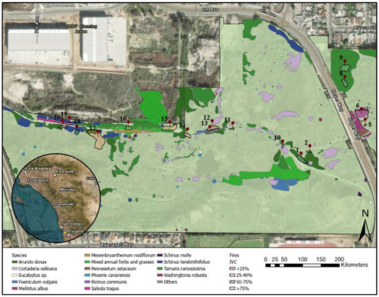
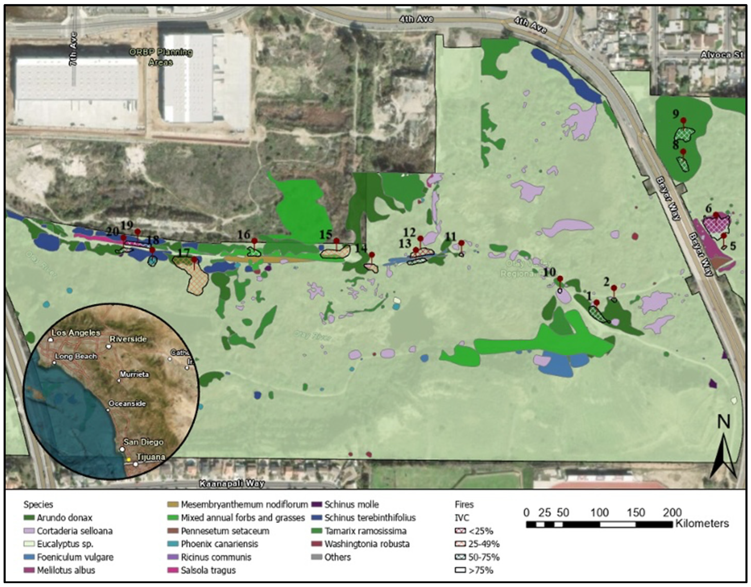
In 2019, the largest active encampment in the last 10 years in the City of San Diego was within OVRP [33]. OVRP was selected because it contains a diverse mixture of native and invasive riparian vegetation, and its location at the urban-wildland interface makes it representative of many urban riparian systems in southern California. Twenty-one brush fires, ignited by activities of individuals experiencing homelessness, burned approximately 6070 m2 between 13 and 15 September 2019. The fire perimeters were mapped in situ by the City of San Diego on 24 September 2019 (Figure 1). The fires occurred near the Otay River, which has both native and non-native vegetation. We analyzed 13 of the 21 fires and excluded Fires 3, 4, 7, and 21, which were outside of the mapped vegetation extent. Additionally, four fires, 2, 5, 10, and 11, were removed as their size was <100 m2, which was smaller than the Sentinel-2 10 m spatial resolution footprint. Although the total burned area was relatively small compared with large regional wildfires, these fires are ecologically and managerially important because they occurred within a sensitive urban riparian corridor. Small, repeated fires in riparian areas can damage native vegetation, reduce canopy cover, facilitate the re-establishment of invasive species, and increase fine fuel availability for future fires.
Figure 1.
Fire perimeters and invasive vegetation cover (IVC) mapped by the City of San Diego within Otay Valley Regional Park (OVRP) in San Diego, California. The yellow solid circle within the circular inset denotes the study area. Fires 3, 4, 7, and 21 were outside of the mapped vegetation extent and excluded from this study.
As a large, multi-jurisdictional urban park in southern San Diego County, OVRP contains a diverse mix of native and invasive riparian vegetation, including Arundo donax, Tamarix ramosissima, and Eucalyptus sp., which are known to influence fire behavior and post-fire recovery. The availability of detailed, ground-verified vegetation maps and fire perimeter data from the City of San Diego for our study of 13 fires allows us to use Sentinel-2 to effectively monitor vegetation health and burn conditions in invaded riparian systems. This high-quality data would be difficult to replicate across multiple sites. Focusing on OVRP thus strengthens our study’s internal validity by controlling for variations in climate, land management, and urban encroachment that could complicate cross-site comparisons. Further, OVRP’s location at the urban-wildland interface and its history of human-caused fire ignitions make it an ideal and representative model for similar urban riparian areas throughout the western U.S.
2.2. Vegetation Classification
The City of San Diego conducted general vegetation surveys from Spring 2018 to Spring 2019 [34]. Mapping the vegetation communities was based on predominant plants or growing patterns (Figure S1) and highly invasive plant species in the OVRP (Figure 1). We calculated the percent cover of vegetation communities and invasive vegetation species within each fire perimeter using the City of San Diego vegetation classification dataset (Table 1). Total IVC within each fire perimeter was categorized into four classes: <25%, 25–49%, 50–75%, and >75%. IVC represents the combined percent cover of invasive species present within each fire perimeter, including Arundo donax, Tamarix ramosissima, Eucalyptus sp., and other mapped invasive vegetation species. Species-specific cover estimates were not mutually exclusive because vegetation was mapped across multiple canopy strata. Consequently, a single location could contain a tall overstory species (e.g., Eucalyptus sp.) and a shorter understory species (e.g., Tamarix ramosissima), resulting in cumulative species cover values exceeding 100% when summed across species. Total IVC, however, was calculated separately as the proportion of each fire perimeter occupied by invasive vegetation regardless of canopy layer.
Table 1.
Burned area and invasive vegetation cover (IVC) within the 13 study fires in OVRP in September 2019. Fires 3, 4, 7, and 21 occurred outside of the mapped vegetation extent and were not included in this study. Fires 2, 5, 10, and 11 did not meet the spatial resolution requirements of our study (>100 m2) and were also removed. Species-specific cover percentages represent mapped cover estimates for individual invasive species and may occur in multiple vertical canopy layers, resulting in a sum greater than 100%.
2.3. Satellite-Based Vegetation Products
The Harmonized Sentinel-2 Multispectral Instrument (MSI) Level-2A dataset is available globally in Google Earth Engine (GEE), which has data from 2016 to the present [35]. Sentinel-2 can be used to map small-scale fires due to higher spatial (10 m) and temporal (5 days) resolution [36]. We utilized all images with <10% cloud cover for the study period to estimate NDVI and NBR. We filtered the image collections by six time periods for each of the 17 study fires in OVRP: pre-fire (15 June 2016 to 12 September 2019), during the fire (13–15 September 2019), and annually and seasonally for four years after the fire. The seasons were defined as: summer (June-August), fall (September-November), winter (December-February), and spring (March-May). A subset of the image collections was generated in Google Earth Engine, and a composite image was subsequently created using the median of the pixels in each band over time.
Our application of Sentinel-2–derived NDVI, dNDVI, and dNBR to assess post-fire vegetation dynamics is similar to recent approaches in wildfire recovery monitoring. Bahramvash Shams et al. (2025) demonstrated that remote sensing metrics effectively documented differences in post-wildfire recovery across vegetation types and land management regimes [37]. Their study highlights the value of satellite-based indices in ecological assessments and the importance of vegetation composition in influencing recovery patterns. Thus, our study focuses on understanding the role of IVC as a key driver of post-fire response in riparian environments.
2.3.1. Normalized Difference Vegetation Index
The NDVI estimates vegetation health through the relation between the absorption of chlorophyll light for photosynthesis in the red wavelength (Red) and the reflectance in the near-infrared (NIR) wavelength [38] (Equation (1)).
NDVI ranges from −1 to 1, where values below 0 typically indicate water. Low values (<0.2) typically represent barren areas like rock, sand, or snow; moderate values (0.2–0.5) represent sparse vegetation or senescing crops; and high values (0.6–0.9) represent dense vegetation such as forests or peak-growth crops [39]. This metric has been used to assess the variation in vegetation before and after fire in urban systems [9]. This study used NDVI to assess plant health before and after fires with varying levels of IVC (Table 1) and annual health fluctuations.
Average NDVI within each fire perimeter was calculated for five time periods: pre-fire and annually and seasonally for four years after the fire in Google Earth Engine. We also estimated the annual canopy loss, dNDVI, due to the fire (Equation (2)):
where x represents the number of years after the fire. Following Mathews and Kinoshita (2021) and Sparks et al. (2016), we classified the canopy loss into the following dNDVI categories: unburned (<0.005), low (0.005 to 0.049), moderate (0.05 to 0.19), and high (>0.2) [9,40].
2.3.2. Differenced Normalized Burn Ratio
Burn severity can be approximated with NBR [41] and represents the immediate environmental impacts of a fire, such as post-fire assessments of vegetation loss [42]. NBR is calculated by the difference in reflectance between NIR and shortwave infrared (SWIR) [43] (Equation (3)). We estimated NBR for the 13 study fires pre-fire and for four years after the fire.
The Differenced Normalized Burn Ratio (dNBR) was calculated by the difference between the pre-fire NBR (NBRPre-Fire) image and each post-fire image for four years after the fire (NBRPost-Fire,x), where x represents the number of years after the fire:
The dNBR estimates changes in surface alterations, such as reduced vegetation cover and moisture, along with greater visibility of ash, char, and bare soil [44], resulting in a composite image that illustrates the spatial extent of the disturbance [45]. Following Key and Benson (2006), we classified the burn severity based on the following dNBR categories: enhanced regrowth (−500 to −101), unburned (−100 to 99), low severity (100 to 269), moderate severity (270 to 659), and high severity (660 to 1300) [43].
2.4. Statistical Analysis
A one-way repeated measures ANOVA was conducted to evaluate the global effect of time on post-fire remote sensing trajectories. ANOVA results (Tables S1–S3) are reported as F(df1, df2) = F statistic, where df1 represents the numerator degrees of freedom, df2 represents the denominator degrees of freedom for the error term, and the F statistic indicates the strength of the tested effect relative to unexplained variation. IVC classes were excluded from the statistical analysis due to the small number of fires and uneven sample sizes across vegetation categories. NDVI and NBR were evaluated across five time points: pre-fire and 1–4 years post-fire. dNDVI was evaluated across four post-fire years, with pre-fire dNDVI defined as zero. The IVC was omitted as a factor in the statistical tests because of the uneven distribution of vegetation categories, specifically n = 1 in the <25% IVC group, and is instead used as descriptive summaries to support ecological interpretation. Descriptive statistics included sample size (n), mean, standard deviation (SD), median, interquartile range (IQR), and range (minimum and maximum). For repeated-measures analysis, the exact p-values and partial η2 values were reported, with statistical significance defined as p < 0.05.
3. Results
3.1. Pre- and Post-Fire Vegetation Density for Invasive Plants
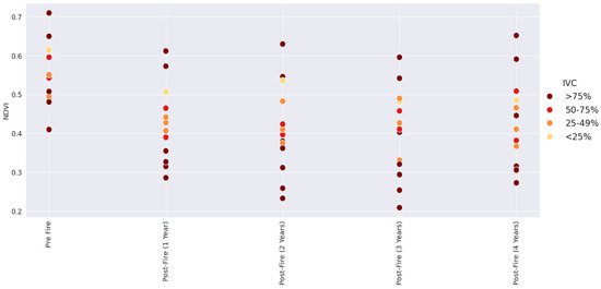
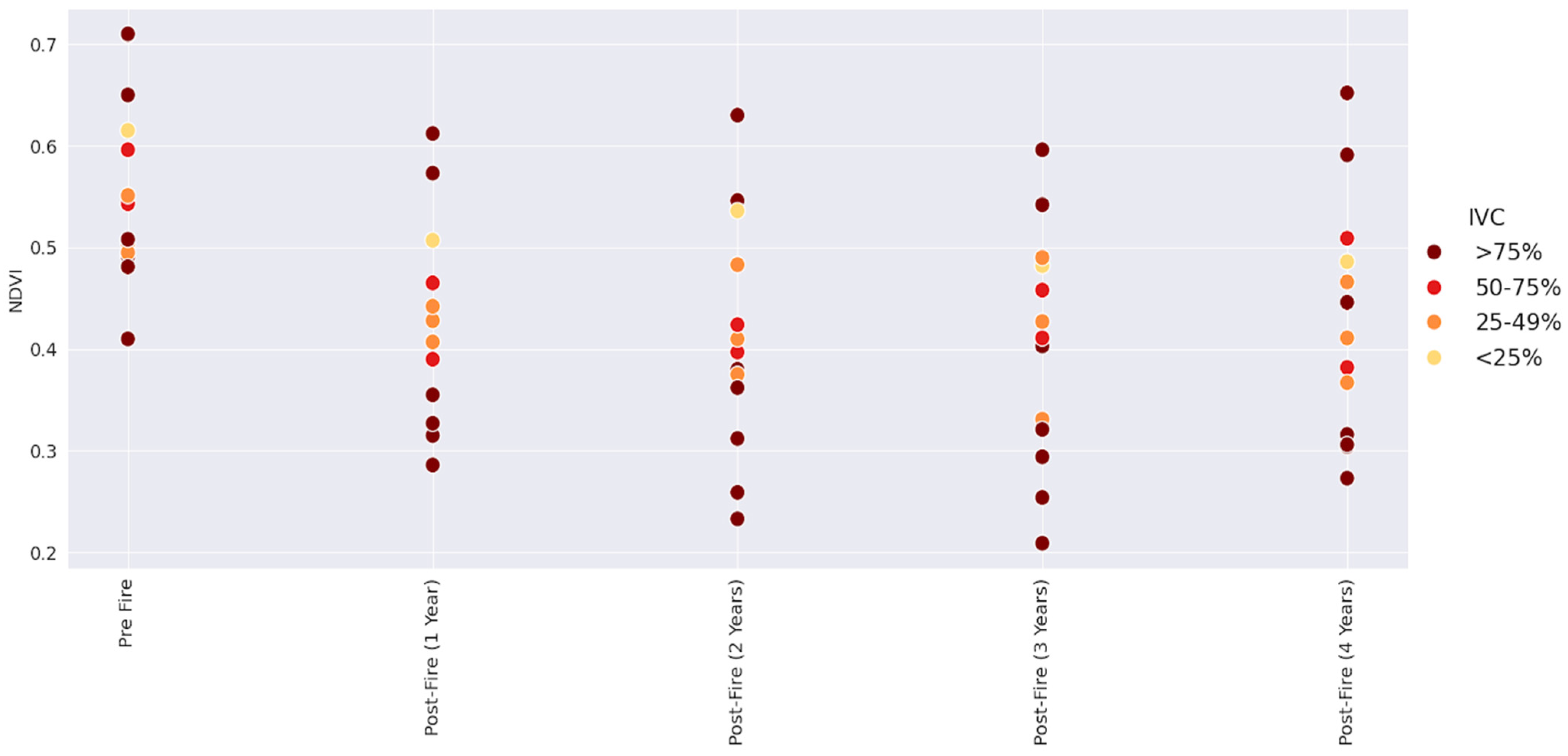
Percent cover of invasive vegetation was calculated for each fire (Table 1). Fire 12 had the lowest percentage of IVC (10%), while Fires 8, 9, 16, 19, and 20 were completely composed of IVC. The average annual NDVI for all years (2019–2023) was categorized by IVC (Figure 2) to correlate vegetation density (NDVI) with percentage of invasive plant cover. Fires with the most invasive vegetation cover (>75% IVC) had the greatest NDVI variability (between 0.23 and 0.71) across all years. The average pre-fire NDVI for each IVC was 0.62 (<25%), 0.52 (25–49%), 0.57 (50–75%), and 0.57 (>75%).
Figure 2.
NDVI for pre-fire and 1, 2, 3, and 4 years after fire, grouped by IVC.
Post-fire NDVI patterns varied across fires with different levels of IVC, but time since fire had the strongest effect on NDVI. Fires with >75% IVC consistently had the highest variability in NDVI before fire (ranging from 0.41 to 0.71) and after fire (four years post-fire ranged from 0.23 to 0.65). Fires 8 and 9, containing Eucalyptus sp. and Tamarix ramosissima, had the highest pre-fire NDVI (0.71), while fires with primarily Arundo donax or mixed annual forb and grasses had the lowest NDVI (0.41–0.49). Fires with <25% IVC had the highest post-fire average NDVI (0.50) across all four years. By the fourth year after the fire, fires with <25% IVC had a mean NDVI of 0.49, lower than the 0.62 observed before the fire (Figure 2).
All fires had higher NDVI under pre-fire conditions regardless of the IVC. NDVI changed significantly over time across all analyzed fires, F(4, 48) = 43.59 and p-value < 0.05 (Table S1), indicating that vegetation greenness varied among the pre-fire and post-fire periods. The >75% IVC class had the greatest variability in annual NDVI values, with SD ranging from 0.122 to 0.154 among time points and NDVI values ranging from 0.209 to 0.710 (Table S4). The <25% IVC class contained only one fire; therefore, within-class SD could not be calculated for individual time points.
3.2. Pre- and Post-Fire Canopy Loss for Invasive Plants
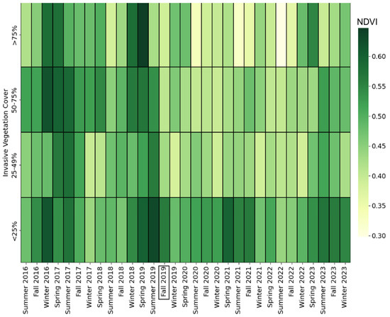
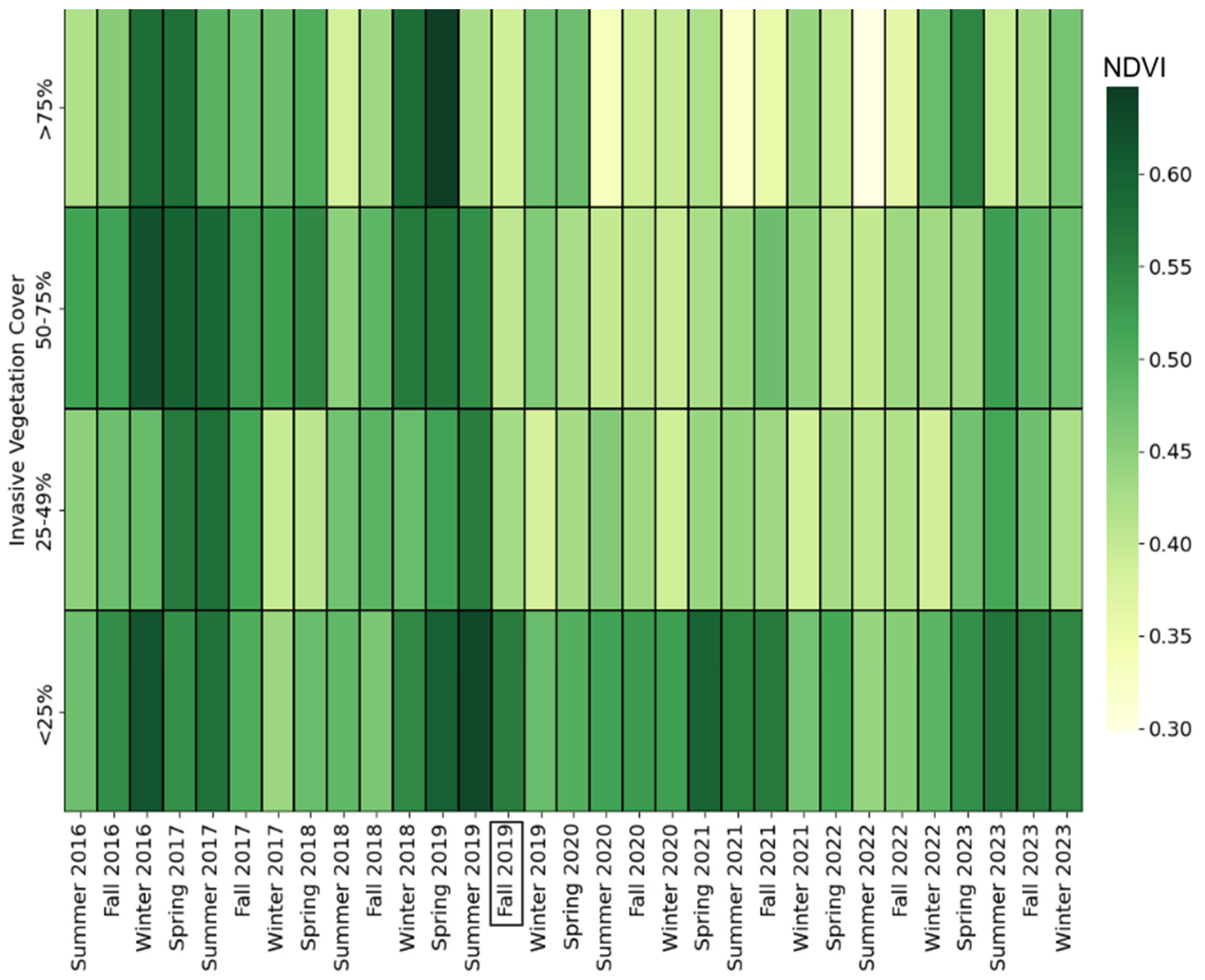
The average seasonal NDVI over three years pre-fire and four years post-fire was classified by IVC (Figure 3) and dNDVI (canopy loss) for all fires (Table 2). All IVC groups had a decrease in NDVI following the fires in Fall 2019.
Figure 3.
Heatmap of IVC and average NDVI for pre-fire (before fall 2019; shown with a black outline) and seasonally for four years after the fire (fall 2019–winter 2023). A black box around Fall 2019 denotes the season when the fires occurred.
Table 2.
Annual canopy loss (dNDVI) by percent of invasive plant cover for the 13 study fires over four years after the fire. Canopy loss categories are unburned (<0.005), low (0.005 to 0.049), moderate (0.05 to 0.199), and high (>0.2). Fires are ordered by increasing percent of invasive cover.
The largest canopy loss (dNDVI = 0.344) occurred in Fire 6 (>75% IVC), which was composed mainly of non-native vegetation, Melilotus albus. Fire 16 had the second-largest canopy loss (dNDVI = 0.28) three years post-fire, composed mostly of 88% mixed annual forbs and grasses. Fire 17 had the second-lowest level of canopy loss (0.005), primarily dominated by Arundo donax, in three years post-fire. Across the four post-fire years, dNDVI did not vary significantly over time for all analyzed fires, F(3, 36) = 1.94 and p-value > 0.05 (Table S2). The >75% IVC class had the highest mean dNDVI in each post-fire year, ranging from 0.153 to 0.191 (Table S4).
3.3. Burn Severity with Respect to Invasive Vegetation Cover
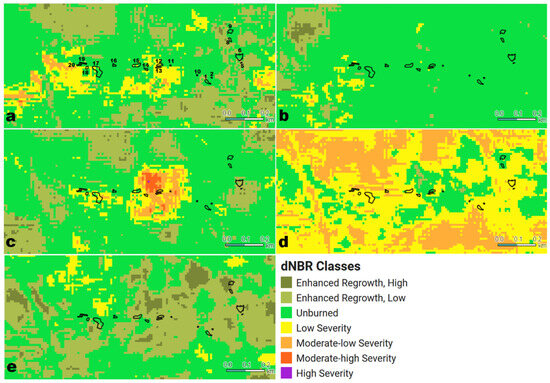
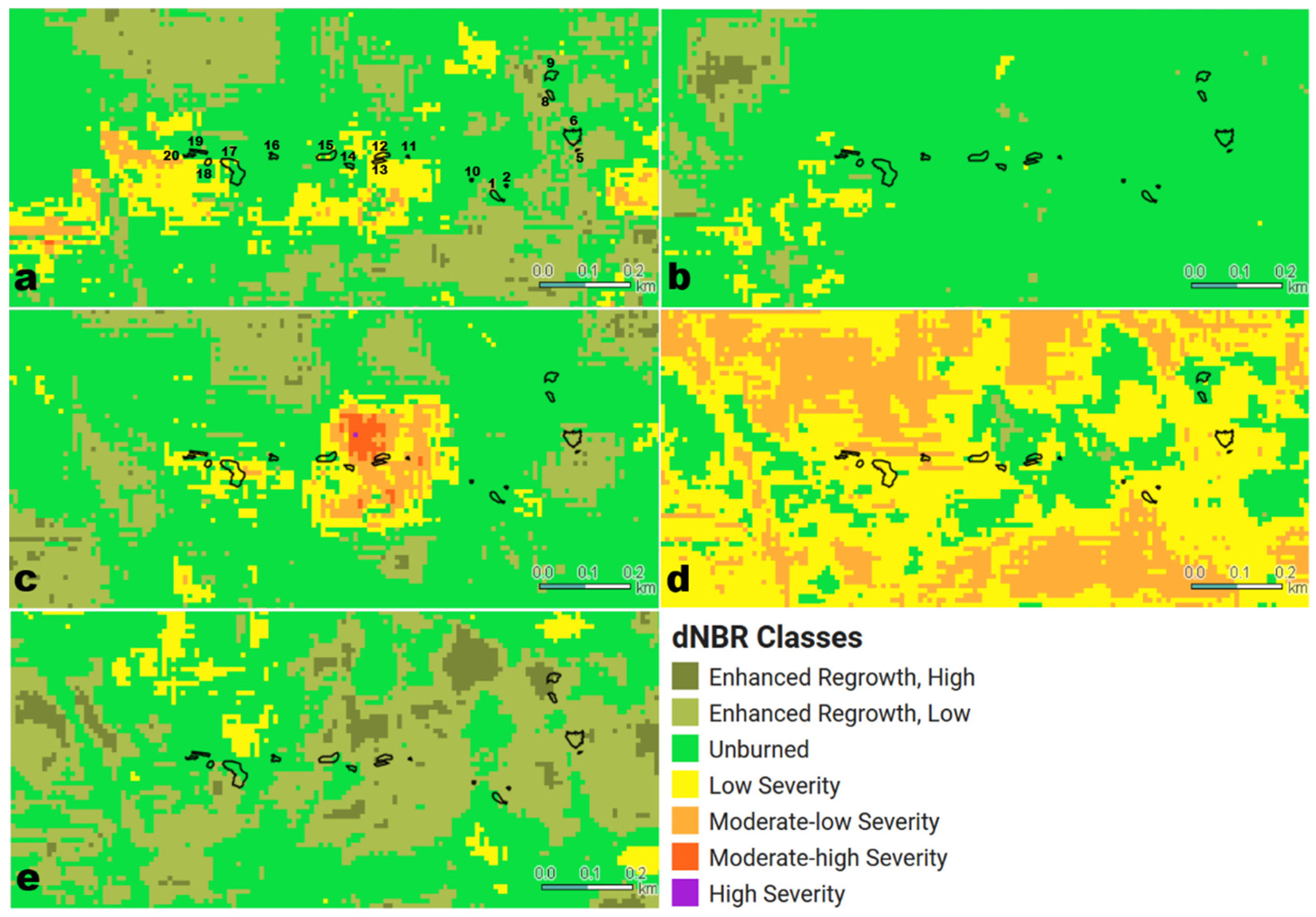
The average NBR was used as a proxy for burn severity and was estimated immediately after the fire for the 13 study fires and annually for four years post-fire. Fires with <25% IVC had the highest average pre-fire NBR (0.31), while those with >75% IVC had the lowest, averaging 0.15. Fire 9 had the highest NBR values across all years, both before and after the fire. Among the post-fire years, fires with <25% IVC recorded the highest average NBR values in years 1, 3, and 4 (0.265, 0.142, and 0.213, respectively). In contrast, fires with >75% IVC consistently had the lowest average NBR in the pre-fire period and in post-fire years 1, 3, and 4 (0.31, 0.26, and 0.39, respectively). The lowest NBR values (−0.03 and −0.02) were observed two and three years post-fire by Fires 1, 19, and 6. By the fourth post-fire year, NBR started to increase (average was 0.26) across all IVC classes and was higher than the pre-fire mean (0.24) (Table S4). NBR changed significantly over time across all analyzed fires, F(4, 48) = 23.88 and p-value < 0.05, indicating that vegetation structure, moisture, or surface condition varied among the pre-fire and post-fire periods. NBR generally decreased after fire across most IVC categories and increased by the fourth post-fire year. The dNBR was estimated and mapped for each fire and four years post-fire to evaluate patterns in burn severity (Figure 4a–e). The dNBR immediately after the fire was categorized as enhanced regrowth, unburned, or low severity for all fires (Figure 4a). However, in the second and third years after the fire, some areas were classified as moderate-high or high severity despite the absence of reported fires. This suggests that dNBR values at two and three years post-fire may reflect non-fire vegetation changes rather than additional burn severity [46]. For example, seasonal phenological changes, prolonged dry periods, vegetation senescence, species-specific post-fire recovery, or other localized disturbances that altered canopy moisture, green biomass, or exposed soil conditions relative to the pre-fire baseline can contribute to these dNBR values.
Figure 4.
Burn severity, approximated by dNBR, for Otay Valley Regional Park for five time periods: (a) immediately after the fire on 13–15 September 2019 and annually on 13–15 September for (b) 2020, (c) 2021, (d) 2022, and (e) 2023. The fire perimeters are outlined in black.
4. Discussion
4.1. Plant Health and Invasive Vegetation Cover
Fires with >75% IVC had both the highest and lowest NDVI values across all time points, highlighting the large variability associated with invasive plant cover (Figure 4). In general, Fire 9, which was composed mostly of non-native Eucalyptus sp. and Tamarix ramosissima, had the highest pre- and post-fire NDVI values. The exception was in the first year after the fire, when Fire 8 (with a similar non-native vegetation composition) had the highest NDVI. Previous studies have observed that Tamarix exhibits rapid recovery after fire due to its efficient water use compared to native trees like Populus fremontii in low-elevation riparian ecosystems of the southwestern United States [47]. Busch (1995) further concluded that Tamarix’s tolerance for water and salinity stress may support its post-fire recovery [47], contributing to its dominance within the plant community after fire events. Eucalyptus sp., an evergreen tree, is highly flammable but rarely suffers fatal damage by fire, allowing quick recovery [20,48].
The significant change in NDVI over time suggests that vegetation greenness responded strongly to the 2019 fire events and subsequent recovery period (Objective 1). However, the high variability observed in the >75% IVC class indicates that highly invaded areas did not respond uniformly after fire, likely reflecting differences in dominant invasive plant species, canopy structure, seasonal phenology, and post-fire recovery strategies. For example, species such as Tamarix ramosissima, Eucalyptus sp., and Arundo donax differ in rooting depth, canopy architecture, water use, and resprouting ability, which can produce different NDVI responses even within the same IVC class [49]. This has been observed in European riparian systems, where the deep rhizome storage and nutrient absorption abilities of the well-established Arundo donax are key to its successful and rapid re-establishment in post-fire environments [50].
4.2. Canopy Loss and Invasive Vegetation Cover
Although no statistically significant relationship was found between IVC and green canopy loss (Objective 2), the observed variation in dNDVI reflects species-specific recovery patterns and growth strategies. Although the >75% IVC class had the highest mean dNDVI, these patterns are interpreted cautiously as IVC categories were not tested for significant differences. Arundo donax’s ability to resprout rapidly from rhizomes after fire allows it to regain canopy cover quickly, even after high initial structural loss [51]. This strategy reduces competition from native plants and sustains the invasive grass-fire cycle. This pattern is consistent with observations from other California riparian systems, including the Santa Clara River and coastal watersheds, where Arundo donax has been documented to rapidly re-establish within native riparian zones after wildfire, reinforcing the potential for an invasive plant–fire feedback cycle [52]. These results suggest that species identity and vegetation structure may be more informative than broad IVC categories for understanding canopy loss after fire.
In contrast, Fire 6, dominated by Melilotus albus, an annual nitrogen-fixing legume, experienced the highest canopy loss. As a shallow-rooted annual, Melilotus lacks the structural and regenerative capacity of perennials like Arundo or Tamarix, making it more susceptible to fire-induced mortality [53]. These findings suggest that canopy loss is a function of life-history traits such as rooting depth, growth form, and reproductive strategy, as well as burn severity. Recognizing these ecological differences is critical for prioritizing post-fire restoration efforts and selecting appropriate control methods for invasive species.
Areas with <25% IVC had the highest post-fire NDVI across multiple years (Figure 3), suggesting that native or less-invaded vegetation communities support a more stable and sustained recovery of green biomass following fire. Native riparian vegetation, particularly in southern California, often includes species adapted to fire through traits like deep rooting systems, fire-stimulated germination, or resprouting capabilities. These traits contribute to more consistent canopy regrowth and vegetation cover over time. In contrast, areas with higher IVC likely experienced more variable recovery due to the differing growth rates, moisture requirements, and seasonal senescence patterns of invasive species, which may result in lower or less stable NDVI signals post-fire.
The accumulation of dense growth and retained dead biomass in high IVC areas (e.g., Arundo donax) leads to greater fuel loads, which may contribute to more intense fires and greater initial vegetation loss. For example, Fires 6 and 16, IVC >75%, consistently had high canopy loss (Table 2). This has been documented in sites with Arundo donax by [9] and [11]. Lower IVC areas, conversely, may experience less intense burns, which can promote quicker and more resilient post-fire vegetation recovery, reflected in higher NDVI values. These findings highlight the importance of maintaining native vegetation and reducing invasive plant dominance to support long-term ecological stability and post-fire resilience.
The results from our study highlight the crucial role of species-specific traits in post-fire vegetation recovery. The minimal canopy loss in Fire 17 (25–49% IVC), dominated by Arundo donax and Schinus terebinthifolius, supports Sirolli and Kalesnik’s (2010) observation that Cortaderia selloana, an invasive grass with a similar growth form, can recover nearly 90% of its original composition within two years after fire [54]. The highest post-fire canopy loss was observed in Fire 6 (>75% IVC), dominated by Melilotus albus, and in Fire 16 (>75% IVC), which was composed of mixed annual forbs and grasses. These results contradicted the findings of DiTomaso et al. (2006), who found that species such as Melilotus albus, annual forbs, and grasses can be effectively managed with early-summer fires [6]. Our late-summer fire did not align with these findings, as significant canopy loss was still observed in subsequent years.
In addition to the high- and low-IVC fires, the mid-range IVC category (25–75%) may represent areas in ecological flux. In these zones, invasive species have not yet fully dominated but are present at levels that could influence post-fire vegetation trajectories. These transitional zones may be particularly vulnerable to type conversion, where recurring disturbances facilitate the replacement of native vegetation with more fire-resilient or fast-growing invasive species. While our remote sensing analysis captured canopy loss, it does not allow us to distinguish the vegetation species over time. Determining whether invasive plants are gradually outcompeting natives in these mid-IVC areas would require targeted field studies to track species presence, regeneration, and interactions post-fire. Li et al. (2022) found that post-fire regeneration rates, growth trajectories, and species functional traits can exert stronger control than mere percent cover on fire feedback loops [55]. Future work should prioritize these zones to assess the risk of long-term ecological transformation and inform proactive management before full conversion occurs.
4.3. Burn Severity and Invasive Vegetation Cover
The significant change in NBR over time indicates that fire and post-fire recovery affected vegetation structure, moisture, or surface condition across the study area (Objective 3). The general decrease in post-fire NBR is consistent with reduced vegetation cover or moisture and increased exposed soil or charred plant material. The increase in NBR by the fourth post-fire year suggests partial recovery of vegetation structure or moisture conditions. However, because NBR is sensitive to the effects of fire and non-fire vegetation changes (drought stress, seasonal senescence, species-specific phenology), NBR patterns are interpreted as changes in vegetation and surface condition rather than fire severity alone [20].
The occurrence of moderate-high and high dNBR classes in the second and third years after the fire, when no additional fires were documented, highlights an important limitation of using dNBR as a direct proxy for fire severity in this riparian ecosystem. The dNBR is sensitive to changes in near-infrared and shortwave infrared reflectance, which are influenced not only by fire, but also by vegetation moisture, canopy structure, exposed soil, seasonal senescence, and post-fire recovery. In southern California riparian systems, strong seasonal drying and interannual drought variability can reduce vegetation moisture and green biomass, potentially producing spectral responses similar to those associated with burn severity. In addition, invasive plant species in OVRP differ in phenology, canopy architecture, and post-fire recovery rates, complicating the interpretation of dNBR values. Therefore, in this study, the two- and three-year post-fire periods should be interpreted as an index of vegetation change or disturbance relative to pre-fire conditions, rather than as evidence of additional fire severity.
The predominance of low-to-low-moderate burn severity suggests that much of the burned vegetation retained some capacity for recovery, particularly where roots, rhizomes, or seed banks survived. However, the potential for recovery likely varied among plant species. Resprouting of rhizomatous invasive species such as Arundo donax and Tamarix ramosissima may recover rapidly after low- to moderate-severity fires, while native woody vegetation recovery may be slower or constrained by competition, moisture availability, and subsequent disturbances such as additional fires, drought, or flooding [20]. Thus, low burn severity does not necessarily indicate ecological resilience of the native plant community; instead, it may create conditions that allow both native and invasive vegetation to regenerate, with outcomes depending on species-specific traits and post-fire management.
The heterogeneity of our urban riparian study site contributes to the lack of correlation between vegetation and burn severity. Unlike homogeneous ecosystems, the complex mosaic of native and invasive vegetation in our area challenges traditional burn-severity metrics and underscores the need for species-specific analysis [56]. Species richness can vary significantly with the same burn severity classification due to the uneven distribution of fire effects [28]. Bolch et al. (2020) also noted that distinguishing species levels can be challenged by the high diversity, varied life forms, and complex canopy structures of riparian vegetation [56].
4.4. Management Implications for Burn-Severity Assessment and Invasive Vegetation Control
These findings also suggest that a relative burn-severity metric may be more appropriate for interpreting fire effects in heterogeneous riparian ecosystems. Miller and Thode (2007) proposed the Relative differenced Normalized Burn Ratio (RdNBR) to account for differences in pre-fire vegetation conditions and biomass [26]. Unlike dNBR, which uses an absolute difference between pre- and post-fire NBR, RdNBR normalizes this change by pre-fire NBR, making it less sensitive to baseline differences among vegetation types [26]. This is particularly relevant in OVRP, where native and invasive riparian vegetation differ substantially in canopy structure, biomass, moisture content, and seasonal phenology. Applying RdNBR may reduce the influence of pre-fire vegetation heterogeneity and may help distinguish true fire effects from drought stress, senescence, or other vegetation changes [57].
Previous studies have demonstrated that pre-fire interventions and land-protection status substantially influence both the severity of wildfires and vegetation recovery trajectories. For example, in ponderosa pine systems, fuel treatments (thinning, prescribed fire, pile burning) reduced burn severity and enabled treated sites to recover in about four years, which was faster than untreated sites [58]. Similarly, Bahramvash Shams et al. (2025) observed that areas without conservation practices had slower and more persistent post-fire vegetation deficits [37]. These results highlight how management history, vegetation composition, and protection status are major determinants of post-fire resilience. In the context of riparian zones invaded by non-native species, examining invasive vegetation as a factor in recovery is especially important, as its structure and regrowth rates often differ from native systems. Further, species-specific traits, including growth form, rooting strategy, canopy structure, biomass accumulation, and resprouting ability, are important for interpreting post-fire recovery patterns and for prioritizing invasive vegetation management.
4.5. Limitations and Opportunities
The small scale of the fires, coupled with the spatial resolution of the satellite imagery and the seasonal senescence of vegetation, could lead to misclassification of burn severity, particularly in areas with mixed vegetation. The classification of moderate-high and high dNBR values in years without reported fires indicates that dNBR may overestimate burn severity in heterogeneous riparian ecosystems when vegetation phenology, drought stress, or non-fire disturbances alter NBR relative to pre-fire conditions. While Sentinel-2 imagery of 10 m spatial resolution offers greater detail than other satellite sensors, misclassification remains likely in the heterogeneous riparian ecosystems where multiple invasive species coexist. The variability observed in our study suggests that remote sensing alone is insufficient, and field monitoring is essential to fully understand the impact of these invasive species on fire behavior.
To enhance the ability to correlate remote sensing metrics with specific species more effectively, future work could leverage phenology traits along with emerging machine learning algorithms (MLAs) such as those employed by Evangelista et al. (2009) and Lake et al. (2022) [27,59]. MLAs can process high-resolution imagery to identify and classify plant species based on their spectral, spatial, and temporal characteristics, which can be more accurate than traditional methods. Deep learning MLAs can effectively distinguish individual species across intricate landscapes, provided that multiple images are analyzed over time [59]. These limitations in burn-severity classification highlight the need for integrating remote sensing with field monitoring to accurately assess fire impacts and guide ecological restoration efforts.
In addition to remote sensing and field-based monitoring, incorporating Traditional Ecological Knowledge (TEK) presents an important opportunity for understanding fire and vegetation dynamics in riparian systems. Indigenous communities have long managed landscapes using intentional fire practices that promote ecological balance, enhance biodiversity, and reduce fuel loads [60,61]. TEK can provide valuable insights into species interactions, fire timing, and long-term ecosystem stewardship that are not captured through satellite imagery or conventional ecological metrics. Future work could benefit from partnerships with local Indigenous communities to integrate TEK into fire management and invasive species control strategies, particularly in urban-riparian environments undergoing rapid ecological change.
5. Conclusions
This study provides insight into post-fire vegetation dynamics in a heterogeneous urban riparian ecosystem using multi-year Sentinel-2 vegetation indices. NDVI and NBR changed significantly over time across the analyzed fires, indicating measurable shifts in vegetation greenness, structure, and moisture conditions during the post-fire period. Descriptive patterns suggest that total IVC alone may not fully explain post-fire recovery. Instead, differences among dominant species, including Arundo donax, Tamarix ramosissima, and Eucalyptus spp., indicate that species-specific traits such as growth form, canopy structure, biomass accumulation, and resprouting ability are important for interpreting post-fire ecological response.
Our results show that total IVC alone did not explain post-fire vegetation recovery or burn-severity patterns and highlight the importance of the differences among dominant species. Areas dominated by Tamarix ramosissima and Eucalyptus spp. maintained higher vegetation index values pre- and post-fire, whereas Arundo donax had rapid resprouting indicative of the invasive grass-fire cycle. These findings suggest that invasive vegetation species should not be treated as a single functional group in post-fire assessments. These findings emphasize the value of integrating remote sensing with field-based vegetation monitoring and leveraging phenological information to better detect species-specific recovery patterns and improve fire impact assessments.
Based on these insights, fire and invasive species management in urban riparian systems should prioritize early, species-targeted interventions. Non-native species that exhibit rapid post-fire regrowth should be removed promptly to prevent re-establishment and reduce fuel loads. Prescribed burns, where appropriate, must be timed to the life cycles of target species, and paired with restoration using native plants to improve long-term resilience. Combining high-resolution remote sensing with on-the-ground monitoring will enable more accurate detection and targeted control. While dNBR is useful for identifying broad vegetation disturbance patterns, it may not reliably isolate fire severity in small, heterogeneous riparian systems without additional field validation or supplemental information about baseline conditions. Collaborative management across agencies, coupled with proactive encampment mitigation strategies, will be essential for reducing ignition risks and supporting sustainable restoration in fire-prone urban riparian zones.
Supplementary Materials
The following supporting information can be downloaded at: https://www.mdpi.com/article/10.3390/fire9070298/s1, Figure S1: Vegetation communities mapped by the City of San Diego from Spring 2018 to Spring 2019.; Table S1. One-way ANOVA repeated measures summary table for vegetation cover and time (pre-fire, 1-4 years post-fire) on NDVI. Table S2. One-way ANOVA repeated measures summary table for vegetation cover and time (pre-fire, 1-4 years post-fire) on dNDVI. Table S3. One-way ANOVA repeated measures summary table for vegetation cover and time (pre-fire, 1-4 years post-fire) on NBR. Table S4. Descriptive statistics included sample size (n), mean, standard deviation (SD), median, interquartile range (IQR), and range (minimum and maximum).
Author Contributions
A.M.L. and A.M.K. conceived and designed the work. A.M.L. and D.J.K. acquired the data. A.M.L., B.B.M., D.J.K. and A.M.K. analyzed and interpreted the data. A.M.L., B.B.M. and A.M.K. contributed substantially to the writing of the manuscript. All authors have read and agreed to the published version of the manuscript.
Funding
This material is based upon work supported by the National Science Foundation CAREER Program under Grant No. 1848577 and National Aeronautics and Space Administration (NASA) Grant No. 80NSSC24K0297.
Data Availability Statement
The datasets analyzed and created for this study can be found in the open-source Mendeley repository with DOI: 10.17632/3p8d26jzw8.1
Acknowledgments
Special thanks to the City of San Diego biologists for providing the data they collected and mapped for use in this research project. This research contains modified Copernicus Sentinel data from 2019 to 2023 made available by the European Commission through Google Earth Engine.
Conflicts of Interest
The authors declare no conflicts of interest.
References
- White, M.; Greer, K. The Effects of Watershed Urbanization on the Stream Hydrology and Riparian Vegetation of Los Penasquitos Creek, California. Landsc. Urban Plan. 2006, 74, 125–138. [Google Scholar] [CrossRef] [Scilit]
- Jamtsho, K.; Lund, M.A.; Blake, D.; Van Etten, E. Urbanisation and specifically impervious cover alter riparian plant communities in a rapidly urbanising landscape in the Himalayas. Urban For. Urban Green. 2025, 110, 128862. [Google Scholar] [CrossRef] [Scilit]
- Griggs, F.T. California Riparian Habitat Restoration Handbook; River Partners: Chico, CA, USA, 2009; Available online: https://riverpartners.org/wp-content/uploads/2023/12/griggs_2009-5.pdf (accessed on 15 February 2025).
- Pettit, N.; Naiman, B. Fire in the riparian zone: Characteristics and ecological consequences. Ecosystems 2007, 10, 673–687. [Google Scholar] [CrossRef] [Scilit]
- Plumanns-Pouton, E.; Bakx, T.R.M.; Buitenwerf, R.; Espelta, J.M.; Moreira, F.; Regos, A.; Brotons, L. Restoring fire regimes through rewilding. Curr. Biol. 2025, 35, R670–R686. [Google Scholar] [CrossRef] [Scilit]
- DiTomaso, J.M.; Brooks, M.L.; Allen, E.B.; Minnich, R.; Rice, P.M.; Kyser, G.B. Control of invasive weeds with prescribed burning. Weed Technol. 2006, 20, 535–548. [Google Scholar] [CrossRef] [Scilit]
- Giessow, J.; Brusati, E. Arundo Donax Distribution and Impact Report; California Invasive Plant Council: Berkeley, CA, USA, 2011; pp. 123–150. Available online: https://www.cal-ipc.org/wp-content/uploads/2017/11/Arundo_Distribution_Impact_Report_Cal-IPC_March-2011_small.pdf (accessed on 20 February 2025).
- California Native Plant Society, Fire Recovery Guide. 2019, pp. 1–92. Available online: https://www.cnps.org/wp-content/uploads/2019/08/cnps-fire-recovery-guide-2019.pdf (accessed on 25 May 2025).
- Mathews, L.E.H.; Kinoshita, A.M. Urban Fire Severity and Vegetation Dynamics in Southern California. Remote Sens. 2021, 13, 19. [Google Scholar] [CrossRef] [Scilit]
- Jennings, M.; Cayan, D.; Kalansky, J.; Pairis, A.D.; Lawson, D.M.; Syphard, A.D.; Abeysekera, U.; Clemesha, R.E.S.; Gershunov, A.; Guirguis, K.; et al. San Diego County Ecosystems: Ecological Impacts of Climate Change on a Biodiversity Hotspot a Report for: California’s Fourth Climate Change Assessment. 2018. Available online: https://www.energy.ca.gov/sites/default/files/2019-12/Biodiversity_CCCA4-EXT-2018-010_ada_0.pdf (accessed on 25 May 2025).
- Drill, S.L. Sustainable and fire-safe landscapes: Achieving wildfire resistance and environmental health in the wildland-urban interface. Fremontia 2010, 38, 37–41. Available online: https://sbfiresafecouncil.org/wp-content/uploads/2020/07/Fremontia_Vol38-No2-3.pdf (accessed on 5 August 2025).
- Halsey, R.W.; Syphard, A.D. High-Severity Fire in Chaparral: Cognitive Dissonance in the Shrublands, in Mixed Severity Fires Nature’s Phoenix; DellaSala, D.A., Hanson, C.T., Eds.; Candice Janco: Summerville, SC, USA, 2024; pp. 163–195. [Google Scholar] [CrossRef] [Scilit]
- Dwire, K.A.; Kauffman, J.B. Fire and riparian ecosystems in landscapes of the western USA. For. Ecol. Manag. 2003, 178, 61–74. [Google Scholar] [CrossRef] [Scilit]
- Kattelmann, R. Embury Sierra Nevada Ecosystem Project: Final Report to Congress, Vol. III, Assessments and Scientific Basis for Management Options. USGS. 1996. Available online: https://pubs.usgs.gov/dds/dds-43/VOL_III/VIII_C21.PDF (accessed on 23 October 2025).
- Shafroth, P.B.; Stromberg, J.C.; Patten, D.T. Riparian Vegetation Response to Altered Disturbance and Stress Regimes. Ecol. Appl. 2002, 12, 107–123. [Google Scholar] [CrossRef]
- Bendix, J. Impact of A Flood On Southern California Riparian Vegetation. Phys. Geogr. 1998, 19, 162–174. [Google Scholar] [CrossRef] [Scilit]
- Donaldson, S.G. Flood-borne Noxious Weeds: Impacts on Riparian Areas and Wetlands. In California Exotic Pest Plant Council Symposium. 1997. Available online: https://www.cal-ipc.org/wp-content/uploads/2017/12/1997_symposium_proceedings1945.pdf (accessed on 4 October 2025).
- Pyšek, P.; Prach, K. How Important Are Rivers for Supporting Plant Invasions? 1994. Available online: https://www.researchgate.net/publication/267836468_How_Important_are_Rivers_for_Supporting_Plant_Invasions (accessed on 31 July 2025).
- Coffman, G.C.; Ambrose, R.F.; Rundel, P.W. Wildfire promotes dominance of invasive giant reed (Arundo donax) in riparian ecosystems. Biol. Invasions 2010, 12, 2723–2734. [Google Scholar] [CrossRef] [Scilit]
- Bell, C.E.; DiTomaso, J.M.; Brooks, M.L. Invasive Plants and Wildfires in Southern California. 2009, pp. 1–5. Available online: https://escholarship.org/content/qt3tk834s7/qt3tk834s7.pdf (accessed on 31 July 2025).
- Kobziar, L.N.; McBride, J.R. Wildfire burn patterns and riparian vegetation response along two northern Si-erra Nevada streams. For. Ecol. Manag. 2006, 222, 254–265. [Google Scholar] [CrossRef] [Scilit]
- Rivard, R. Homeless Camps Along the San Diego River Surge Amid Downtown, in Voice of San Diego. 2017. Available online: https://voiceofsandiego.org/2017/10/27/homeless-camps-along-the-san-diego-river-surge-amid-downtown-enforcement-push/ (accessed on 5 August 2024).
- Syphard, A.D.; Keeley, J.E. Location, timing and extent of wildfire vary by cause of ignition. Int. J. Wildland Fire 2015, 24, 37–47. [Google Scholar] [CrossRef] [Scilit]
- CALFIRE-FRAP, California’s Forests and Rangelands: 2017 Assessment. 2017, CALFIRE. pp. 1–318. Available online: https://34c031f8-c9fd-4018-8c5a-4159cdff6b0d-cdn-endpoint.azureedge.net/-/media/calfire-website/what-we-do/fire-resource-assessment-program---frap/assessment/forest-and-range-2017-assessment.pdf?rev=2bf31f9791b94f3dab50810119148eff&hash=C4DEDCB3814FA15DC69BBC11ED601FC2 (accessed on 31 July 2025).
- Smith, D.; Queally, J.; Molina, G. 24 Fires a Day: Surge in Flames at L.A. Homeless Encampments a Growing Crisis, in Los Angeles Times. 2021. Available online: https://www.latimes.com/california/story/2021-05-12/surge-in-fires-at-la-homeless-encampments-growing-crisis (accessed on 4 October 2025).
- Miller, J.D.; Thode, A.E. Quantifying burn severity in a heterogeneous landscape with a relative version of the delta Normalized Burn Ratio (dNBR). Remote Sens. Environ. 2007, 109, 66–80. [Google Scholar] [CrossRef] [Scilit]
- Evangelista, P.H.; Stohlgren, T.J.; Morisette, J.T.; Kumar, S. Mapping Invasive Tamarisk (Tamarix): A Comparison of Single-Scene and Time-Series Analyses of Remotely Sensed Data. Remote Sens. 2009, 1, 519–533. [Google Scholar] [CrossRef] [Scilit]
- Lentile, L.B.; Morgan, P.; Hudak, A.T.; Bobbitt, M.J.; Lewis, S.A.; Smith, A.M.S.; Robichaud, P.R. Post-Fire Burn Severity and Vegetation Response Following Eight Large Wildfires Across the Western United States. Fire Ecol. 2007, 3, 91–108. [Google Scholar] [CrossRef] [Scilit]
- Hardwick, J.; Hackney, C.; Keen, L.; Fitzsimmons, C.; Willby, N.; Pattison, Z. The Role of Non-Native Plant Species in Modulating Riverbank Erosion: A Systematic Review. River Res. Applic 2025, 41, 757–772. [Google Scholar] [CrossRef] [Scilit]
- Dickens, S.J.; Allen, E. Exotic plant invasion alters chaparral ecosystem resistance and resilience pre- and post-wildfire. Biol. Invasions 2014, 16, 1119–1130. [Google Scholar] [CrossRef] [Scilit]
- Otay Valley Regional Park, Habitat Restoration Plan and Non-Native Plant Removal Guidelines. 2006. Available online: https://sdmmp.com/view_article.php?cid=CID_abernabe%40usgs.gov_59b1b25f73645 (accessed on 30 June 2025).
- County of San Diego; City of Chula Vista; City of San Diego; Otay Valley Regional Park Citizens Advisory Committee. Otay Valley Regional Park Trail Guidelines. 2003. Available online: https://www.sandiego.gov/sites/default/files/ovrptrailguidelines.pdf (accessed on 31 July 2025).
- City of San DiegoDiego, MSCP Management Actions Report. Recreation, Editor. 2019; pp. 1–56. Available online: https://www.sandiego.gov/sites/default/files/attachment_5_-_mscp_management_report_2019.pdf (accessed on 4 May 2026).
- San Diego Association of Governments; SanGIS. Regional Data Warehouse. Available online: https://gis-sangis1.hub.arcgis.com/pages/download-data (accessed on 22 June 2026).
- European Space Agency. Sentinel-2 User Handbook. 2015, pp. 1–64. Available online: https://sentinels.copernicus.eu/documents/247904/685211/Sentinel-2_User_Handbook (accessed on 5 August 2024).
- Qarallah, B.; Othman, Y.A.; Al-Ajlouni, M.; Alheyari, H.A.; Qoqazeh, B.A. Assessment of Small-Extent Forest Fires in Semi-Arid Environment in Jordan Using Sentinel-2 and Landsat Sensors Data. Forests 2023, 14, 41. [Google Scholar] [CrossRef] [Scilit]
- Bahramvash Shams, S.; Boehnert, J.; Wilhelmi, O. Assessing the Impact of Conservation Practices on Post-Wildfire Recovery of Evergreen and Conifer Forests Using Remote Sensing Data. Fire 2025, 8, 92. [Google Scholar] [CrossRef] [Scilit]
- Rouse, W., Jr.; Haas, R.H.; Well, J.A.; Deering, D.W. Monitoring Vegetation Systems in the Great Plains with ERTS. 1974; pp. 1–9. Available online: https://ntrs.nasa.gov/api/citations/19740022614/downloads/19740022614.pdf (accessed on 12 October 2025).
- Brown, J. NDVI, the Foundation for Remote Sensing Phenology. 2018. Available online: https://www.usgs.gov/special-topics/remote-sensing-phenology/science/ndvi-foundation-remote-sensing-phenology#overview (accessed on 12 October 2025).
- Sparks, A.M.; Kolden, C.A.; Talhelm, A.F.; Smith, A.M.S.; Apostol, K.G.; Johnson, D.M.; Boschetti, L. Spectral Indices Accurately Quantify Changes in Seedling Physiology Following Fire: Towards Mechanistic Assessments of Post-Fire Carbon Cycling. Remote Sens. 2016, 8, 572. [Google Scholar] [CrossRef] [Scilit]
- Lutes, D.C.; Keane, R.E.; Caratti, J.F.; Key, C.H.; Benson, N.C.; Sutherland, S.; Gangi, L.J. FIREMON: Fire Effects Monitoring and Inventory System; Gen. Tech. Rep. RMRS-GTR-164; U.S. Department of Agriculture, Forest Service, Rocky Mountain Research Station: Fort Collins, CO, USA, 2006. [Google Scholar] [CrossRef] [Scilit]
- Delcourt, C.J.F.; Combee, A.; Izbicki, B.; Mack, M.C.; Maximov, T.; Petrov, R.; Rogers, B.M.; Scholten, R.C.; Shestakova, T.A.; van Wees, D.; et al. Evaluating the Differenced Normalized Burn Ratio for Assessing Fire Severity Using Sentinel-2 Imagery in Northeast Siberian Larch Forests. Remote Sens. 2021, 13, 2311. [Google Scholar] [CrossRef] [Scilit]
- Key, C.; Benson, N. Landscape Assessment: Ground Measure of Severity, the Composite Burn Index; and Remote Sensing of Severity, the Normalized Burn Ratio. 2006. Available online: https://pubs.usgs.gov/publication/2002085 (accessed on 12 October 2025).
- Howe, A.A.; Parks, S.A.; Harvey, B.J.; Saberi, S.J.; Lutz, J.A.; Yocom, L.L. Comparing Sentinel-2 and Landsat 8 for Burn Severity Mapping in Western North America. Remote Sens. 2022, 14, 5249. [Google Scholar] [CrossRef] [Scilit]
- Gorelick, N.; Hancher, M.; Dixon, M.; Ilyushchenko, S.; Thau, D.; Moore, R. Google Earth Engine: Planetary-scale geospatial analysis for everyone. Remote Sens. Environ. 2017, 202, 18–27. [Google Scholar] [CrossRef] [Scilit]
- Keeley, J. Fire intensity, fire severity and burn severity: A brief review and suggested usage. Int. J. Wildland Fire 2009, 18, 116–126. [Google Scholar] [CrossRef] [Scilit]
- Busch, D.E. Effects of Fire on Southwestern Riparian Plant Community Structure. Southwest. Nat. 1995, 40, 259–267. Available online: http://www.jstor.org/stable/30055166 (accessed on 19 June 2026).
- Esser, L.L. Eucalyptus Globulus. 1993. Available online: https://www.fs.usda.gov/database/feis/plants/tree/eucglo/all.html#3 (accessed on 4 October 2025).
- Drus, G. Fire Ecology of Tamarix. Tamarix: A Case Study of Ecological Change in the American West; Oxford Academic: Oxford, UK, 2015. [Google Scholar] [CrossRef] [Scilit]
- Jiménez-Ruiz, J.; Hardion, L.; Monte, J.; Vila, B.; Santín-Montanyá, M. Monographs on invasive plants in Europe N° 4: Arundo donax L. Bot. Lett. 2021, 168, 131–151. [Google Scholar] [CrossRef] [Scilit]
- Kato-Noguchi, H.; Kato, M. The Invasive Mechanism and Impact of Arundo donax, One of the World’s 100 Worst Invasive Alien Species. Plants 2025, 14, 2175. [Google Scholar] [CrossRef] [Scilit] [PubMed] [PubMed Central]
- Stillwater Sciences. Giant Reed. Santa Clara River Parkway. Available online: https://parkway.scrwatershed.org/theriver/species/giant-reed-arundo-donax.html (accessed on 22 June 2026).
- Zhang, C.; Wu, F.; Yan, Q.; Duan, Z.; Wang, S.; Ao, B.; Han, Y.; Zhang, J. Genome-Wide Analysis of the Rab Gene Family in Melilotus albus Reveals Their Role in Salt Tolerance. Int. J. Mol. Sci. 2022, 24, 126. [Google Scholar] [CrossRef] [Scilit] [PubMed] [PubMed Central]
- Sirolli, H.; Kalesnik, F. Effects of fire on a forest-grassland ecotone in De La Plata River, Argentina. Plant Ecol. 2010, 212, 689–700. [Google Scholar] [CrossRef] [Scilit]
- Li, Z.; Angerer, J.P.; Wu, X.B. The impacts of wildfires of different burn severities on vegetation structure across the western United States rangelands. Sci. Total Environ. 2022, 845, 157214. [Google Scholar] [CrossRef] [Scilit]
- Bolch, E.A.; Santos, M.J.; Ade, C.; Khanna, S.; Basinger, N.T.; Reader, M.O.; Hestir, E.L. Remote Detection of Invasive Alien Species. In Remote Sensing of Plant Biodiversity; Cavender-Bares, J., Gamon, J.A., Townsend, P.A., Eds.; Springer: Cham, Switzerland, 2020. [Google Scholar] [CrossRef] [Scilit]
- Miller, J.D.; Knapp, E.E.; Key, C.H.; Skinner, C.N.; Isbell, C.J.; Creasy, R.M.; Sherlock, J.W. Calibration and validation of the relative differenced Normalized Burn Ratio (RdNBR) to three measures of fire severity in the Sierra Nevada and Klamath Mountains, California, USA. Remote Sens. Environ. 2009, 113, 645–656. [Google Scholar] [CrossRef] [Scilit]
- Dodge, J.M.; Strand, E.K.; Hudak, A.T.; Bright, B.C.; Hammond, D.H.; Newingham, B.A. Short- and long-term effects of ponderosa pine fuel treatments intersected by the Egley Fire Complex, Oregon, USA. Fire Ecol. 2019, 15, 40. [Google Scholar] [CrossRef] [Scilit]
- Lake, T.A.; Briscoe Runquist, R.D.; Moeller, D.A. Deep learning detects invasive plant species across complex landscapes using Worldview-2 and Planetscope satellite imagery. Remote Sens. Ecol. Conserv 2022, 8, 875–889. [Google Scholar] [CrossRef] [Scilit]
- Ray, L.A.; Kolden, C.A.; Chapin, F.S. A Case for Developing Place-Based Fire Management Strategies from Traditional Ecological Knowledge. Ecol. Soc. 2012, 17, 37. Available online: http://www.jstor.org/stable/26269081 (accessed on 4 October 2025). [CrossRef] [Scilit]
- Lake, F.K.; Wright, V.; Morgan, P.; McFadzen, M.; McWethy, D.; Stevens-Rumann, C. Returning Fire to the Land: Celebrating Traditional Knowledge and Fire. J. For. 2017, 115, 343–353. [Google Scholar] [CrossRef] [Scilit]

Disclaimer/Publisher’s Note: The statements, opinions and data contained in all publications are solely those of the individual author(s) and contributor(s) and not of MDPI and/or the editor(s). MDPI and/or the editor(s) disclaim responsibility for any injury to people or property resulting from any ideas, methods, instructions or products referred to in the content. |
© 2026 by the authors. Licensee MDPI, Basel, Switzerland. This article is an open access article distributed under the terms and conditions of the Creative Commons Attribution (CC BY) license.