


Abstract
Forest fires pose significant threats to ecological security, human settlements, and sustainable regional development, particularly in mountainous regions with complex environmental and anthropogenic conditions. Previous studies have yet to construct a forest fire risk assessment framework that integrates multi-source data, which limits the comprehensiveness and accuracy of existing assessments. To address this gap, taking Liangshan Prefecture in China as a case study, this research selected eight risk factors to characterize vegetation conditions, topographic features, climatic conditions, and human activities. A combined weighting approach integrating the mandatory determination method and the coefficient of variation method was employed to determine the weights of different indicators. Forest fire risk probability was calculated using a weighted comprehensive evaluation model, and spatial autocorrelation analysis based on global Moran’s I and local indicators of spatial association (LISA) was further conducted to investigate spatial clustering characteristics. The results indicate that high-risk and very high-risk areas are mainly concentrated in southeastern Liangshan, particularly in Xichang, Jinyang, Ningnan, Huili, and Huidong, where warmer climatic conditions, dense vegetation coverage, mountainous terrain, and intensive human activities jointly contribute to elevated forest fire risk. The global Moran’s I value of 0.219175 indicates significant positive spatial autocorrelation in forest fire risk distribution. Validation using historical fire-scar data from 2010 to 2020 showed that 83.66% of the fire scars were distributed within medium-, high-, and very high-risk areas, suggesting that the proposed assessment framework provides a reasonable representation of forest fire risk patterns in Liangshan. The findings of this study can support regional forest fire prevention planning, targeted resource allocation, and risk management in mountainous areas.
1. Introduction
Forest fires are one of the serious natural disasters facing the world, and the threat they pose to ecosystems, human inhabitants and economies cannot be ignored [1,2]. The frequency and scale of forest fires are showing an increasing trend due to the combined effects of climate change, adverse human activities and poor forest management [3,4,5]. The United Nations Strategic Plan for Forests 2017–2030 emphasizes the critical role of forests in sustainable development, which underscores the high priority that the international community attaches to sustainable forest management [6,7,8]. To effectively address this challenge, risk assessment has become one of the focal points for researchers and policymakers [9,10,11,12]. Forest fire risk assessment aims to assess and quantify the likelihood and severity of forest fires to help decision-makers develop effective fire prevention measures and emergency response plans [13,14,15,16]. Çolak et al. [17] employed a combination of multi-temporal remote sensing data, ancillary data, and a geographic information system (GIS) to assess the spatiotemporal patterns of forest fire risk in the Mandeles region of Izmir. Similarly, Lin et al. [18] proposed a forest fire prediction model based on LSTNet, using remote sensing satellites and GIS to identify the factors affecting forest fires. Bui et al. [19] developed a GIS database of tropical forest fires and a spatial model to assess forest fire risk in Lam Dong Province, Vietnam. Remote sensing techniques were employed to examine fire incidence in Valmiki Tiger Reserve. Gao et al. [20] developed a forest fire risk prediction model for the Heihe region in Heilongjiang province, employing random forest and back propagation neural network algorithms. This novel approach demonstrated the potential of machine learning techniques in improving the accuracy of risk assessment. Lan et al. [21] constructed a spatial prediction model of forest wildfire sensitivity using logistic regression and then applied it to assess the risk of forest wildfires in Yunnan province, China. By focusing on sensitivity analysis, their approach provided valuable insights into the factors that exacerbate fire risk. Zhao et al. [22] took Nanjing Laoshan National Forest Park as the study area and used hierarchical analysis to classify the forest fire occurrence level based on meteorological data, topographical data, and proximity to residential areas and roads. This multi-dimensional assessment provided a holistic understanding of risk determinants. These studies collectively underscore the vital role of risk assessment in forest fire prevention and management. By integrating remote sensing data, GIS, and other ancillary data, researchers can accurately assess fire risk and provide a scientific basis to develop targeted fire prevention measures and post-disaster recovery plans.
However, several limitations still exist in current forest fire risk assessment studies. First, many existing studies mainly focus on meteorological or vegetation-related variables, while the combined influences of topographic conditions, human activities, and spatial heterogeneity are not sufficiently integrated into a unified assessment framework. Second, although machine learning and GIS-based methods have been widely applied, fewer studies have simultaneously combined subjective expert knowledge and objective statistical weighting approaches to improve the interpretability and consistency of assessment results. Third, most existing studies mainly focus on fire occurrence prediction or susceptibility mapping, whereas relatively limited attention has been paid to the spatial clustering characteristics and county-level spatial autocorrelation of forest fire risk. To fill these gaps, this paper integrated multi-source data for forest fire risk assessment, and used fire scars data to validate the effectiveness of the proposed method.
Liangshan, situated in Sichuan province, represents one of the largest forest resources in southwest China, playing a crucial role in upholding the integrity of the Earth’s ecosystem and ensuring climate stability [23,24,25]. This region has experienced a surge in forest fires in recent years, resulting in significant loss of life and substantial economic damages. Furthermore, forest fires may also trigger secondary disasters such as landslides and mudslides, further endangering human lives [26,27]. Moreover, forest fires can inflict severe damage on the ecological environment, including the destruction of vegetation, soil erosion, and water pollution, thereby significantly impacting the local ecosystem and biodiversity [28,29,30]. For instance, on 30 March 2019, a forest fire erupted in Muli, Liangshan and killed 31 people. Similarly, on 30 March 2020, another forest fire occurred in Xichang, Liangshan, causing the loss of 19 lives and resulting in direct economic losses of 97,311,200 yuan [31,32,33]. Additionally, on 20 April 2021, yet another forest fire broke out in Mianning, Liangshan. These fires resulted in casualties and burned houses, causing huge losses to local residents. Consequently, there is an urgent imperative to undertake a comprehensive assessment of forest fire risks within the region and implement long-term preventive measures to mitigate future occurrences of forest fires.
In this study, we first constructed a comprehensive model for forest fire risk assessment based on multi-source data. This model encompassed a comprehensive analysis of various factors, including forest ecosystems, meteorological conditions, geographic features, human activities, and vegetation conditions, to predict the probability of fire occurrence and estimate its potential impact range. A case study was carried out in Liangshan, China. The performance of this proposed model was validated through the fire-trail data. Then, we employed Moran’s I to explore the spatial correlation of forest fire risk in each county of Liangshan. By accurately assessing forest fire risk, decision-makers can better understand and evaluate the risks of forest fires to humans and the natural environment, as well as develop appropriate prevention and management strategies to minimize fire hazards and damage.
The main objectives of this study are as follows:
- (1)
- To develop a comprehensive forest fire risk assessment framework integrating multi-source datasets, including ecological, meteorological, geographic, vegetation, and anthropogenic factors.
- (2)
- To combine the mandatory determination method and coefficient of variation method to improve the comprehensiveness and consistency of forest fire risk weighting and assessment.
- (3)
- To investigate the spatial clustering characteristics and county-level spatial autocorrelation patterns of forest fire risk in Liangshan using Moran’s I and LISA spatial statistical methods.
- (4)
- To validate the spatial correspondence between historical fire-scar distribution and modeled forest fire risk patterns in Liangshan Prefecture.
2. Study Area and Data
2.1. Study Area
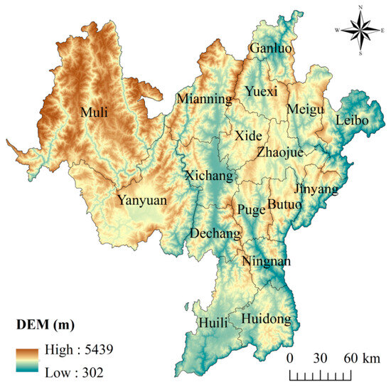
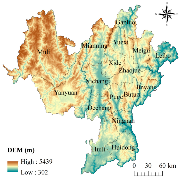
The Liangshan Yi Autonomous Prefecture, situated in the southwestern part of Sichuan Province, China, encompasses 17 counties and cities. The topography of this region is characterized by high elevations in the northwest, lower elevations in the southeast, and a mix of high and low terrain in the northern and southern areas. The geological structure is complex, and the landforms are diverse, encompassing plains, basins, hills, mountains, and plateaus (as shown in Figure 1). This study area is located in a subtropical monsoon climate zone and boasts a large area of natural ecological landscape including primeval forests, alpine meadows, lakes and rivers. With a total area of 60,400 square kilometers, Liangshan has a resident population of 4,874,000 and a gross regional product of 208.136 billion yuan by the end of 2022.
Figure 1.
The topographic map of Liangshan.
2.2. Data
2.2.1. Factors of Forest Fire Risk
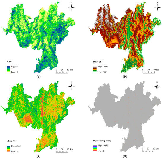
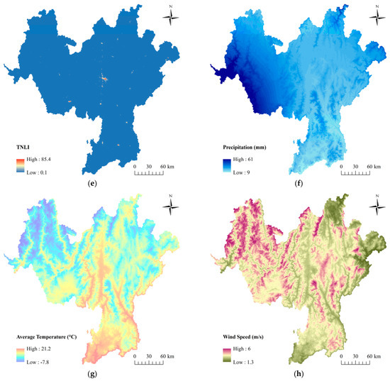
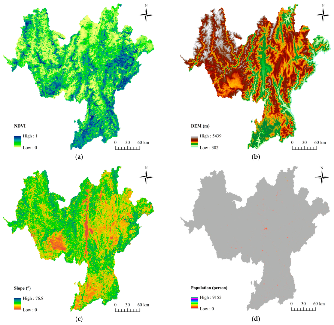
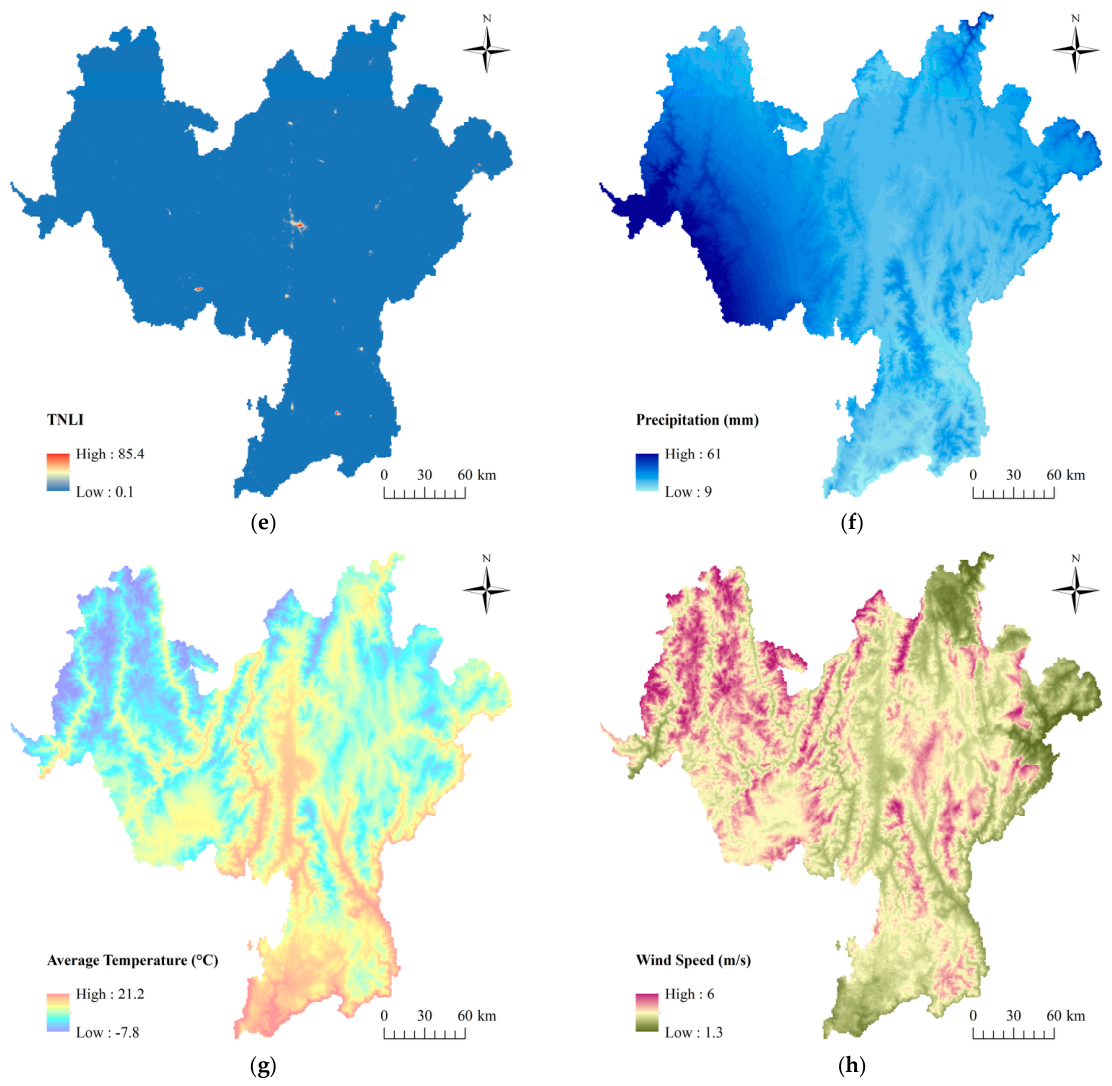
Forest fire occurrence is generally driven by the combined effects of vegetation conditions, topographic characteristics, meteorological factors, and anthropogenic disturbances. Previous studies have demonstrated that these dimensions collectively determine fuel availability, fire ignition probability, and fire spread dynamics [34,35]. Therefore, based on the classical forest fire driving mechanism framework and considering the ecological characteristics and data availability of the study area, this study selected eight representative indicators from four dimensions, including normalized difference vegetation index (NDVI), digital elevation model (DEM), slope, population, total nighttime light index (TNLI), precipitation, average temperature and wind speed (as shown in Figure 2). The selection process prioritized the scientific nature of the indicators by choosing multiple representative forest fire risk factors. Additionally, emphasis was placed on ensuring the relative independence of each indicator, minimizing the overlap between them to enhance the accuracy of the assessment model [36]. Finally, the establishment of the assessment model was designed to be feasible and operational. This consideration ensures the practicality of the assessment system, enabling it to provide valuable guidance for forest fire prevention and management.
Figure 2.
Spatial patterns of the eight forest fire risk factors used in the assessment model. (a) NDVI; (b) DEM; (c) Slope; (d) Population; (e) TNLI; (f) Precipitation; (g) Average Temperature; (h) Wind Speed.
The attributes and sources of each fire risk factor are presented in Table 1. The forest fire risk factors are categorized as positive and negative indicators. Positive indicators indicate a higher likelihood of forest fire occurrence as the indicator value increases, whereas negative indicators suggest a lower likelihood of forest fire occurrence as the indicator value increases. Positive indicators encompass the NDVI, slope, population, TNLI [37,38], average temperature, and wind speed [39]. The NDVI reflects the condition and density of vegetation [40]. The slope size directly influences the moisture content variation in combustible materials, with steeper slopes leading to increased water loss and drying of combustible materials [41]. Additionally, slope steepness significantly affects heat transfer. Upslope fires can increase the rate of fire spread due to experience heightened convective and radiant heat intensity. Population and TNLI represent human activities [42,43], which are prominent factors in forest fires. Fires caused by human activities, such as unextinguished campfires, cigarette butts, and smoldering fires, contribute to fire occurrences [44,45]. Moreover, population growth often corresponds with urban sprawl and suburban development, blurring the boundaries between forests and human-occupied areas, thereby increasing fire risks. Temperature is a vital factor in the initiation and spread of forest fires [46,47]. Elevated temperatures cause vegetation to lose water through evaporation, increasing its fire risk probability and facilitating flame propagation. Wind speed is a significant factor in the spread and growth of forest fires. Higher wind speeds expedite fire spread, enlarging the fire’s reach and size. Conversely, negative indicators consist of the DEM and Precipitation. A higher DEM indicates relatively lower temperatures, increased rainfall, and a more humid climate, which renders it less prone to fires. Moreover, precipitation directly influences fire occurrence, spread, and extinguishment. Adequate rainfall raises vegetation and surface material moisture levels, reducing their flammability and acting as a natural barrier against fire spread.
Table 1.
Attributes and sources of forest fire risk factors.
To ensure consistency among the multi-source datasets, all raster datasets were projected to the same coordinate system and resampled to a unified spatial resolution of 1 km × 1 km. The preprocessing procedures included mosaicking, clipping, resampling, and raster alignment in ArcGIS 10.8. Meteorological and socioeconomic datasets with different original spatial resolutions were interpolated or resampled to match the target resolution.
2.2.2. Fire Scars
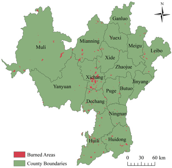
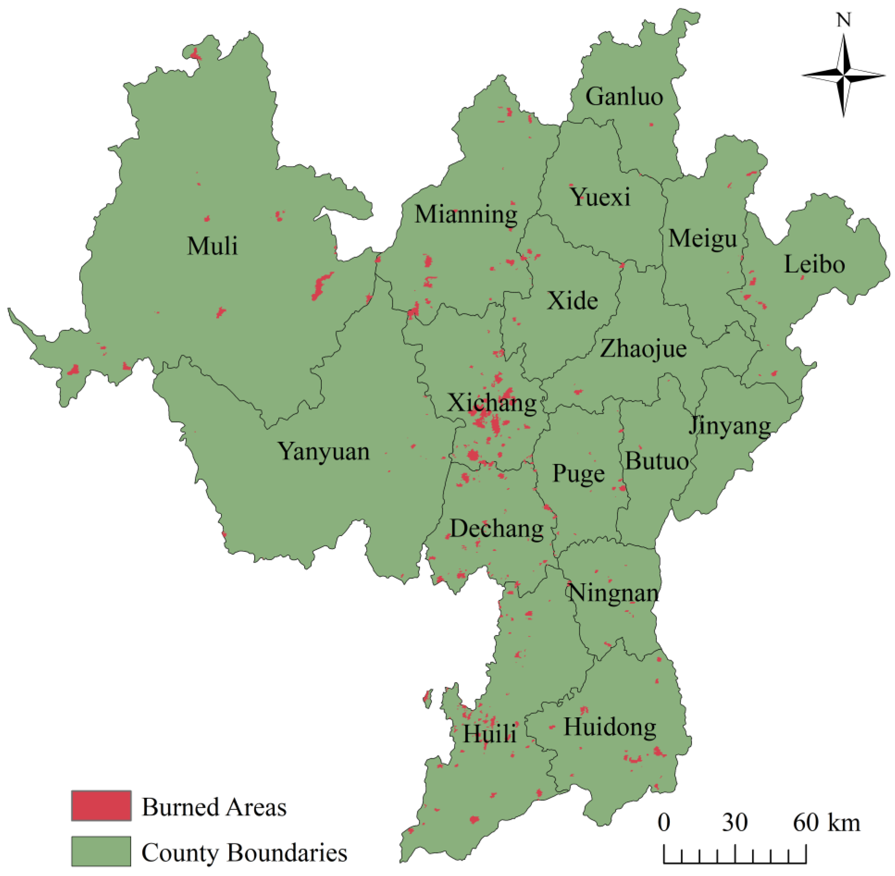
The fire scars data were generated by overlaying monthly products from 2010 to 2020 [48,49]. These data were obtained from the AI Earth Science Cloud platform (https://engine-aiearth.aliyun.com) and used to validate forest fire risk assessment results. By superimposing these historical data, we extracted fire traces with a magnitude greater than 0 and assigned them a value of 1, while unburned areas were designated as 0. This process yielded a binarized spatial distribution of fire scars, as illustrated in Figure 3. The fire scars exhibit clear spatial clustering characteristics, with most burned areas concentrated in the central and southeastern parts of Liangshan. In contrast, relatively fewer fire scars are observed in the northwestern mountainous regions. This spatial pattern may be associated with differences in vegetation conditions, climatic factors, topographic features, and the intensity of human activities across the region. Areas with higher population density and stronger human disturbances tend to show more frequent fire occurrences.
Figure 3.
Spatial pattern of historical fire scars in Liangshan from 2010 to 2020.
3. Methodology
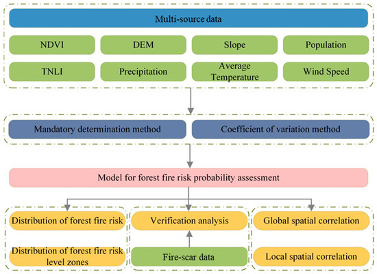
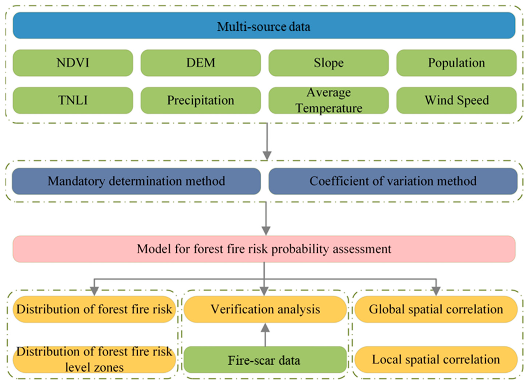
This study aims to construct a comprehensive model for forest fire risk assessment based on multi-source data. The overall workflow of this study is presented in Figure 4. In this study, the risk probability was assessed based on multi-source data using the forced determination method and the coefficient of variation method. In addition, the assessment results were validated using fire-scar data.
Figure 4.
The workflow of this study.
3.1. Forest Fire Risk Assessment
3.1.1. Creating a Fishnet and Extracting Attribute Values
In this study, we used ArcGIS 10.8 to “create a fishnet” for the boundary vector data of Liangshan. The fishnet squares were configured to measure 1 km × 1 km, resulting in a total of 60,959 squares. The selection of the 1 km spatial resolution was based on a balance between spatial detail, computational efficiency, and the resolution consistency of the multi-source datasets used in this study. Most of the risk factor datasets, including meteorological and socioeconomic variables, were available at kilometer-level or resampled resolutions, making the 1 km grid suitable for integrated spatial analysis. In addition, a finer resolution may introduce excessive local noise and increase computational complexity, whereas a coarser resolution could obscure spatial heterogeneity in forest fire risk patterns. Subsequently, the raster images representing the eight risk factors underwent partition statistics to extract the attribute values of the risk factors within each fishnet square, thereby facilitating subsequent analyses.
3.1.2. Standardization of Risk Factors
To address the variations in units among different indicators, it is necessary to standardize each indicator to ensure that their values fall within the range of 0 to 1. The calculation for standardizing positive indicators is presented in Equation (1), whereas Equation (2) illustrates the standardization equation for negative indicators.
where is the normalized value, is the attribute value of an indicator, is the maximum value of an indicator, and is the minimum value of an indicator.
3.1.3. Determination of Weights
In forest fire risk assessment, relying solely on either subjective or objective weighting methods may introduce potential bias and uncertainty. Subjective methods can effectively incorporate expert knowledge and practical experience, but they may be influenced by personal judgment. In contrast, objective methods determine weights according to the statistical characteristics of the data, but they may overlook the actual ecological and management significance of certain indicators. Therefore, this study combined the mandatory determination method and the coefficient of variation method to balance expert judgment and data-driven information. The combined weighting approach helps improve the robustness and reliability of the assessment framework by reducing the limitations associated with a single weighting method.
The mandatory determination method used in this study refers to a subjective expert judgment-based weighting approach. It involves determining the relative importance of each indicator, creating a weight discrimination table, and calculating the weights of each indicator based on the table. When two indicators are considered to have the same importance, they are each assigned 2 points; when one indicator is shown to be more important than the other, the former is assigned 3 points and the latter is assigned 1 point; when one indicator is significantly more important than the other, the former is assigned 4 points and the latter is assigned 0 points. As shown in Equation (3), and the indicator weights obtained by this method are shown in Table 2. As shown in Table 2, population and TNLI received relatively higher subjective weights, indicating that human activities were considered major contributors to forest fire occurrence in Liangshan. In contrast, DEM and slope obtained relatively lower weights, suggesting that topographic factors were regarded as indirect influencing factors compared with anthropogenic drivers. The weighting results reflect the strong influence of human disturbance and socioeconomic activities on regional forest fire risk.
where is the index weight determined by the forced judgment method, is the number of indexes, is the score of the th index, and is the total score of each index.
Table 2.
Determination of the weights of the mandatory determination method of risk factors.
The coefficient of variation method is a relatively objective research method. Based on the data of each indicator, we calculated the mean and standard deviation of each indicator separately, as in Equation (4).
where is the coefficient of variation of the indicator, is the mean of the indicator, and is the standard deviation of the indicator.
Next, the coefficients of variation for each indicator were summed using Equation (5). Subsequently, the weights of each indicator were calculated using Equation (6). Table 3 presents the objective weights derived from the coefficient of variation method. Population and TNLI exhibited relatively large coefficients of variation, indicating substantial spatial heterogeneity across Liangshan. Consequently, these indicators obtained higher objective weights. In contrast, wind speed and precipitation showed relatively smaller variation coefficients, resulting in lower weights. These findings suggest that anthropogenic factors exhibit stronger spatial differentiation than some natural environmental variables in the study area.
where is the sum of variation coefficients of each indicator, and is the weight of the indicator determined by the coefficient of variation method.
Table 3.
Risk factor coefficient of variation method weight determination.
In this study, based on the weights determined by the two methods, the combined weights of each indicator were obtained by multiplying the two weights using Equation (7), and the results are presented in Table 4.
where is the combined weight of each index, is the index weight determined by the forced determination method, and is the index weight determined by the coefficient of variation method.
Table 4.
Determination of combined weights of risk factors.
3.1.4. Probability Assessment
The probability of forest fire risk in Liangshan was calculated using Equation (8).
where is the forest fire risk probability, is the combined weight of each indicator, and is the standardized value of each indicator.
3.2. Spatial Correlation
In this study, global Moran’s I and local spatial association index (LISA) were employed to examine the zonal spatial relationships of forest fire risk levels [50,51]. An inverse distance-based spatial weight matrix was adopted in the Moran’s I and LISA analyses to characterize the spatial interactions among neighboring spatial units, where geographically closer units were assigned higher spatial weights. The global Moran’s I was calculated by Equation (9), which yields values ranging from −1 to 1. Values close to 1 indicate a strong positive correlation, while values close to −1 indicate a strong negative correlation, and values near 0 indicate an insignificant correlation [52]. To delve deeper into spatial correlation, we further utilized the local Moran’s I calculated by Equation (10). By utilizing these indices, we can uncover the extent of spatial correlation among different regions, thereby elucidating the spatial distribution patterns of forest fire risk levels.
where is the number of regions, is the rank of forest fire risk in a region, is the average forest fire risk rank, and is the spatial symmetry weight.
4. Results
4.1. Distribution of Forest Fire Risk
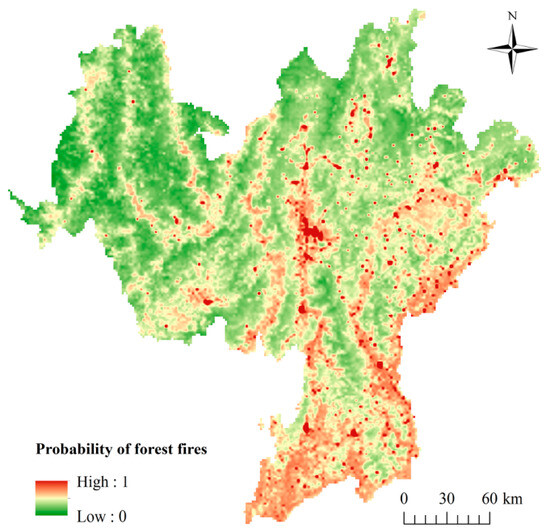
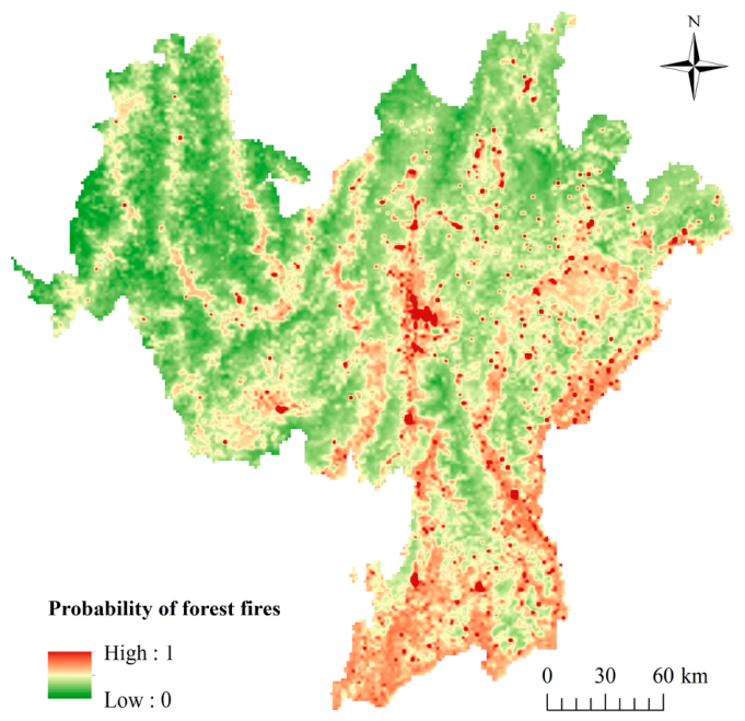
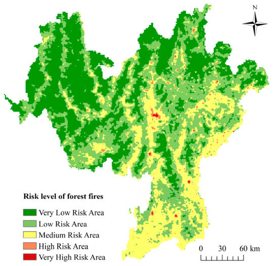
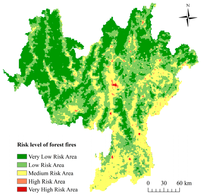
Based on the aforementioned methodology, we obtained the forest fire risk probability indices for each fishnet square and standardized them. These indices were then assigned to each fishnet square, resulting in the distribution of forest fire risk probability in Liangshan, as shown in Figure 5. The forest fire risk probability is higher in the east-central part of Liangshan, while the risk probability is lower in the west. Moreover, the forest fire risk probability exhibits a striped distribution pattern, exhibiting a certain degree of coincidence with the administrative boundaries of counties and districts. To categorize the forest fire risk in Liangshan, we divided the risk probability into five classes using the natural breaks method: “Very High Risk Area”, “High Risk Area”, “Medium Risk Area”, “Low Risk Area”, and “Very Low Risk Area”, as shown in Figure 6. The areas classified as “Very High Risk Area” and “High Risk Area” are relatively small and closely coincide with densely populated regions and areas with high nighttime light intensity. On the other hand, the “Medium Risk Area” and “Low Risk Area” exhibit a more widespread distribution, while the “Very Low Risk Area” is primarily concentrated in the northwestern part of Liangshan. It is evident that the forest fire risk in Liangshan displays spatial heterogeneity and is closely linked to population distribution and economic development.
Figure 5.
Distribution of forest fire risk probability.
Figure 6.
Distribution of forest fire risk levels.
4.2. Distribution of Forest Fire Risk Level Zones
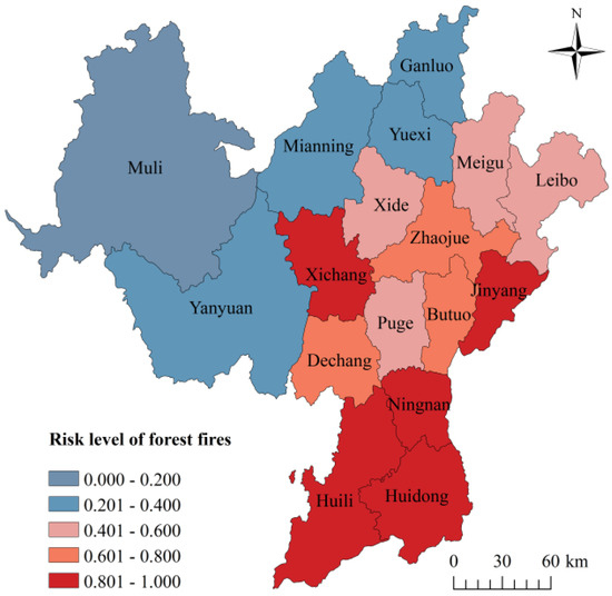
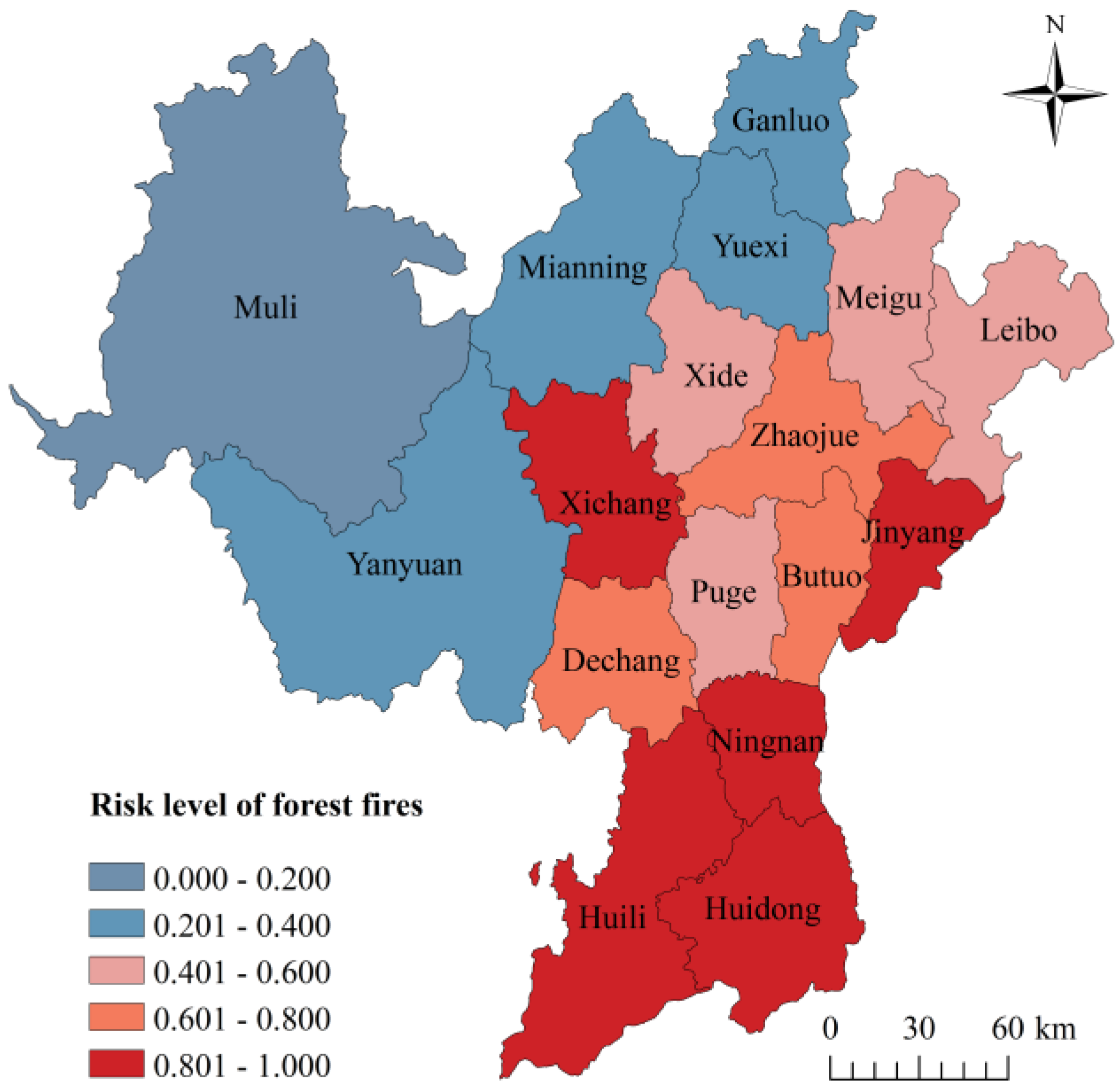
The distribution of forest fire risk levels in each county of Liangshan is shown in Figure 7. The overall pattern demonstrates higher risk in the southeast and lower risk in the northwest. Specifically, Xichang, Jinyang, Ningnan, Huili and Huidong exhibit the highest forest fire risk. This can be attributed to several factors, including higher population density, flatter terrain, higher temperatures, and lower rainfall in these counties. Conversely, Muli experiences lower forest fire risk due to its higher terrain, lower temperatures, higher rainfall, and sparse population. Additionally, forest fire risk is higher in Dechang, Zhajue and Butuo, moderate in Xide, Meigu, Leibo and Puge, and low in Yangyuan, Mianning, Ganluo and Yuexi. These variations indicate significant spatial differences in forest fire risk within the Liangshan surrounding region. Areas characterized by dense populations, flat terrain, high temperatures, and low rainfall are more susceptible to forest fires. Conversely, areas with higher elevations, lower temperatures, higher rainfall, and sparse populations tend to have lower forest fire risk.
Figure 7.
Distribution of forest fire risk level in each county of Liangshan.
4.3. Validation of Forest Fire Risk
In this study, the forest fire risk assessment results were validated using synthetic fire-trail data from 2010 to 2020. The validation results are presented in Table 5, which encompasses two aspects of validation. On the one hand, based on the global data validation, we assigned a value of 1 to the areas classified as “Medium Risk Area” and above in the forest fire assessment results, and a value of 0 to the areas classified as “Low Risk” and “Very Low Risk”. These results were then compared with the fire-trail data. The results indicated that the probability of both having the same number was 77.13%. On the other hand, we conducted a validation solely based on the fire area. We determined the probability of the fire area falling within the medium risk and above areas, which amounted to 83.66%. Both validation results indicate that the forest fire risk assessment method proposed in this study has high reliability in Liangshan. The method accurately reflects the actual forest fire risk situation, providing a relatively stable and dependable approach for assessing forest fire risks.
Table 5.
Forest fire risk validation.
4.4. Global Spatial Correlation of Forest Fire Risk
To conduct a global spatial analysis of forest fire risk in each county of Liangshan, we employed the global Moran’s I for assessment. The global Moran’s I is 0.219175. The positive value of Moran’s I indicate that there is a positive spatial correlation in the probability of forest fire risk across each county in Liangshan. Additionally, the p value, which is less than 0.05 and close to 0.01, suggests that the spatial correlation passed the significance test at 95% and close to a 99% confidence level. The presence of this spatial correlation provides a more comprehensive understanding of the distribution of forest fire risk probability in Liangshan. It serves as valuable guidance for the development of corresponding fire prevention and control strategies and resource allocation.
4.5. Local Spatial Correlation of Forest Fire Risk
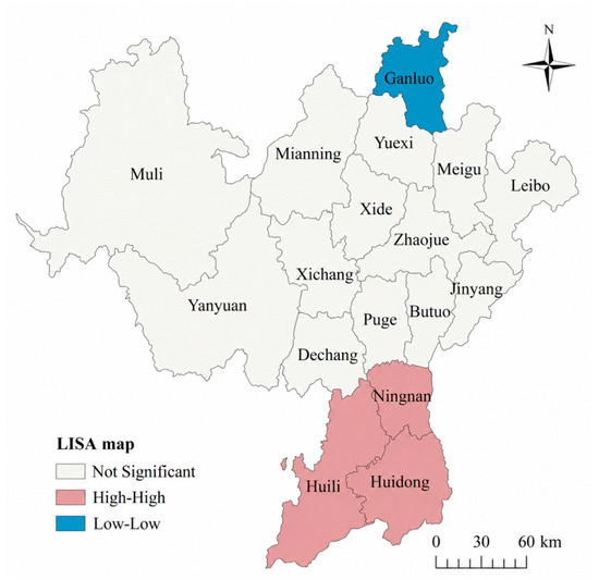
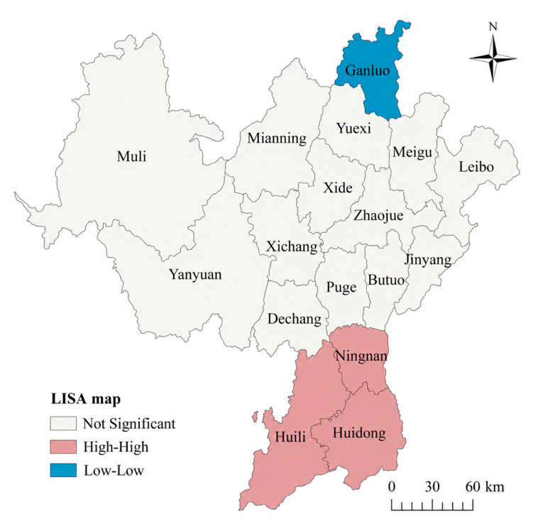
To further examine the spatial correlation of forest fire risk in each county of Liangshan, we further conducted local spatial clustering analysis and generated a fire risk LISA map, as shown in Figure 8. Most of the counties in Liangshan belong to the “Not Significant” type, the spatial clustering phenomenon is not obvious. These counties are located in the central region. This indicates that there is no significant spatial correlation between the forest fire risk probability in these areas and the forest fire risk probability in the surrounding counties. The “High-High” type is mainly distributed in the southern part of Liangshan, including Ningnan, Huili and Huidong, where the forest fire risk probability is high and has a certain “synergistic effect”, the risk level between neighboring counties is relatively high. The “Low-Low” type is only distributed in the northern part of Liangshan, and only Ganluo belongs to this type. This is because the forest fire risk probability in Yuexi County, which borders Ganluo, is also low, making the fire risk level in Ganluo County significantly different from that in the surrounding counties. The results of these local spatial clustering analyses allow us to better understand the spatial distribution characteristics of forest fire risk in each county and district of Liangshan. The findings provide a vital reference for further optimization of fire prevention and control strategies, resource allocation, and related policy formulation.
Figure 8.
LISA map of forest fire risk.
5. Discussions
The assessment results reveal clear spatial heterogeneity in forest fire risk across Liangshan Prefecture. High-risk and very high-risk areas are mainly concentrated in Xichang, Jinyang, Ningnan, Huili, and Huidong, whereas relatively lower-risk areas are primarily distributed in the northwestern mountainous regions. This spatial pattern is closely associated with the combined influences of human activities, climatic conditions, vegetation characteristics, and topographic features [53,54]. Among the selected factors, population and TNLI exhibited relatively high combined weights, indicating that anthropogenic activities play an important role in forest fire occurrence in Liangshan. Xichang, Huili, and Huidong are characterized by relatively high population density, stronger nighttime light intensity, convenient transportation networks, and more intensive economic activities. These characteristics increase the probability of human-induced ignition sources, including agricultural burning, transportation-related fire use, smoking, tourism activities, and accidental ignition events. In addition, Ningnan and Jinyang are located in regions with relatively dry and warm climatic conditions, which can accelerate vegetation moisture loss and increase fuel flammability. The southeastern part of Liangshan also contains large areas of vegetation cover and mountainous terrain, where slope conditions may further promote fire spread through enhanced heat transfer and upslope flame propagation. These findings suggest that forest fire risk in Liangshan is jointly controlled by both environmental background conditions and human disturbances, although anthropogenic factors appear to exert stronger direct influences on fire occurrence.
The spatial autocorrelation analysis further demonstrated significant clustering characteristics of forest fire risk. The positive global Moran’s I value indicates that areas with similar fire risk levels tend to cluster spatially rather than distribute randomly. Local spatial autocorrelation analysis revealed that high-high clustering areas were mainly concentrated in southeastern Liangshan, while low-low clustering areas were more common in northwestern counties with higher elevations and relatively humid climatic conditions. These spatial clustering characteristics are generally consistent with the historical distribution of fire scars from 2010 to 2020, further supporting the rationality of the proposed assessment framework.
The results obtained in this study are generally consistent with previous forest fire risk studies conducted in Sichuan Province and southwestern China, which have reported that forest fires are strongly associated with climatic drought, vegetation conditions, topographic complexity, and increasing human disturbances. Previous studies have similarly indicated that regions with dense human activities and warmer climatic conditions are more susceptible to fire occurrence [55,56]. Compared with studies relying solely on meteorological or vegetation indicators, the present study incorporated multi-source datasets and simultaneously considered ecological, climatic, geographic, and anthropogenic factors. In addition, the combined weighting approach integrated both subjective expert knowledge and objective statistical information, thereby improving the comprehensiveness and robustness of the assessment framework.
The weighting results further highlight the relative importance of different risk factors in the model. Population and TNLI exhibited relatively large weights and strong spatial heterogeneity, indicating that human activity intensity is an important driver of fire occurrence in Liangshan. Temperature and NDVI also contributed substantially to the assessment results. Higher temperatures can reduce vegetation moisture and increase fuel combustibility, while higher NDVI values generally indicate greater vegetation coverage and fuel availability. In contrast, DEM and precipitation showed relatively lower weights, although these factors still influence the environmental suitability and spread conditions of forest fires. These findings indicate that forest fire occurrence in Liangshan is influenced by the interaction between natural environmental conditions and anthropogenic disturbances rather than a single dominant factor.
Although the proposed framework demonstrated relatively good validation performance, several limitations and uncertainties should be acknowledged. First, the multi-source datasets used in this study were obtained from different platforms and periods, which may introduce temporal inconsistencies and spatial uncertainties during data integration. Some explanatory variables were represented using long-term average conditions or single-year datasets, which may not fully capture short-term dynamic environmental changes. Second, the forest fire risk map produced in this study is relatively static and mainly reflects long-term spatial susceptibility rather than real-time fire ignition probability. Third, some potentially important variables, including fuel type, vegetation structure, land-cover change, and dynamic human activity intensity, were not incorporated because of data availability limitations. Fourth, although the combined weighting method reduced the bias associated with a single weighting approach, uncertainties related to indicator weighting and model assumptions still exist. In addition, fire susceptibility does not necessarily represent actual fire ignition events, because real fire occurrence may also be influenced by accidental or sudden external factors. Future studies should further incorporate higher-resolution dynamic datasets, real-time meteorological monitoring, land-cover change information, and advanced machine learning techniques to improve the temporal sensitivity, robustness, and predictive capability of forest fire risk assessment models.
Overall, this study provides a comprehensive framework for assessing forest fire risk in Liangshan using multi-source spatial datasets and spatial statistical methods. The findings can support forest fire prevention planning, resource allocation, and targeted risk management in high-risk regions. More importantly, the study highlights the importance of integrating environmental and anthropogenic factors to better understand the spatial distribution characteristics of forest fire risk in mountainous regions of southwestern China.
6. Conclusions
In this study, a comprehensive model for forest fire risk probability and risk level assessment was constructed based on multi-source data. The mandatory determination method and the coefficient of variation method were employed to determine indicator weights, and the assessment results were validated using historical fire-scar data. A case study was conducted in Liangshan, China. The results show a clear spatial heterogeneity of forest fire risk, with higher risk concentrated in the east-central part of Liangshan and lower risk in the western mountainous areas. Specifically, the highest forest fire risk is observed in Xichang, Jinyang, Ningnan, Huili, and Huidong, while relatively low risk is found in Muli County. Validation results indicate that 83.66% of historical fire scars fall within medium, high, and very high-risk zones, demonstrating reasonable agreement between observed fire distribution and modeled risk patterns. In addition, spatial autocorrelation analysis revealed a significant positive spatial clustering pattern of forest fire risk across Liangshan Prefecture, with “High-High” clusters mainly distributed in southeastern Liangshan and “Low-Low” clusters primarily located in the northwestern regions. These findings provide a scientific basis for differentiating fire prevention strategies across the region, guiding targeted resource allocation, improving regional risk management, and supporting long-term ecological conservation in Liangshan.
Based on the identified spatial heterogeneity of forest fire risk, more targeted management strategies are recommended. First, for high-risk counties such as Xichang, Jinyang, Ningnan, Huili, and Huidong, where population density, transportation accessibility, and human activity intensity are relatively high, it is necessary to strengthen human activity regulation in forest-edge areas, especially during dry and high-temperature seasons. Fire source control measures such as restricting open burning, enhancing tourism fire supervision, and strengthening infrastructure management along transportation corridors should be prioritized. Second, in these high-risk southeastern areas characterized by complex terrain and dense vegetation, early warning systems should be enhanced by integrating real-time meteorological monitoring with spatial fire risk maps to improve rapid response capability. Third, for relatively low-risk counties such as Muli, ecological conservation and vegetation stability should remain the focus, maintaining their role as natural buffers in the regional fire risk pattern.
Author Contributions
Conceptualization, W.L.; Methodology, W.L. and Y.S. (Yanmeng Shang); Software, W.L. and Y.S. (Yanmeng Shang); Validation, W.L. and Y.S. (Yanmeng Shang); Formal analysis, W.L.; Investigation, W.L.; Resources, Y.S. (Yun Shen); Data curation, W.L. and Y.S. (Yun Shen); Writing—original draft preparation, W.L.; Writing—review and editing, G.H.; Visualization, W.L. and Y.S. (Yun Shen); Supervision, G.H. All authors have read and agreed to the published version of the manuscript.
Funding
This research received no external funding.
Institutional Review Board Statement
Not applicable.
Informed Consent Statement
Not applicable.
Data Availability Statement
Data will be made available on request.
Conflicts of Interest
The authors declare no conflicts of interest.
Abbreviations
The following abbreviations are used in this manuscript:
| DEM | Digital Elevation Model |
| GIS | Geographic Information System |
| LISA | Local Indicators of Spatial Association |
| NDVI | Normalized Difference Vegetation Index |
| TNLI | Total Nighttime Light Index |
References
- Boer, M.M.; Resco de Dios, V.; Bradstock, R.A. Unprecedented burn area of Australian mega forest fires. Nat. Clim. Change 2020, 10, 171–172. [Google Scholar] [CrossRef] [Scilit]
- Li, T.; Cui, L.; Liu, L.; Chen, Y.; Liu, H.; Song, X.; Xu, Z. Advances in the study of global forest wildfires. J. Soils Sediments 2023, 23, 2654–2668. [Google Scholar] [CrossRef] [Scilit]
- Huang, G.; Yue, H.; Shui, B.; Li, D.; Guo, Z. Rethinking the role of driving factors in developing carbon mitigation strategies: Evidence from the central heating sector in China. J. Clean. Prod. 2026, 561, 148421. [Google Scholar] [CrossRef] [Scilit]
- Mansoor, S.; Farooq, I.; Kachroo, M.M.; Mahmoud, A.E.D.; Fawzy, M.; Popescu, S.M.; Alyemeni, M.; Sonne, C.; Rinklebe, J.; Ahmad, P. Elevation in wildfire frequencies with respect to the climate change. J. Environ. Manag. 2022, 301, 113769. [Google Scholar] [CrossRef] [Scilit] [PubMed]
- Huang, G.; Guo, Z.; Xiong, R.; Li, D.; Lin, W.; Yue, H. Customized decarbonization strategies for central heating in 142 Chinese cities: Combining spatial decomposition with cluster analysis. J. Clean. Prod. 2025, 525, 146531. [Google Scholar] [CrossRef] [Scilit]
- United Nations. United Nations Strategic Plan for Forests, 2017–2030; United Nations Digital Library: Online, 2017. [Google Scholar]
- Baskent, E.Z. Characterizing and assessing key ecosystem services in a representative forest ecosystem in Turkey. Ecol. Inform. 2023, 74, 101993. [Google Scholar] [CrossRef] [Scilit]
- Serrano-Ramírez, E.; Valdez-Lazalde, J.R.; de los Santos-Posadas, H.M.; Mora-Gutiérrez, R.A.; Ángeles-Pérez, G. A forest management optimization model based on functional zoning: A comparative analysis of six heuristic techniques. Ecol. Inform. 2021, 61, 101234. [Google Scholar] [CrossRef] [Scilit]
- Naderpour, M.; Rizeei, H.M.; Khakzad, N.; Pradhan, B. Forest fire induced Natech risk assessment: A survey of geospatial technologies. Reliab. Eng. Syst. Saf. 2019, 191, 106558. [Google Scholar] [CrossRef] [Scilit]
- Wang, W.; Zhang, X.; Zhang, X.; Liu, W.; Zheng, H.; Liu, Y. Integrated seismic damage scenario and resilience assessment using multimodal data and support vector machine, a case study of Jiangyou City, Southwestern China. Geomat. Nat. Hazards Risk 2026, 17, 2607461. [Google Scholar] [CrossRef] [Scilit]
- Li, W.; Xu, Q.; Yi, J.; Liu, J. Predictive model of spatial scale of forest fire driving factors: A case study of Yunnan Province, China. Sci. Rep. 2022, 12, 19029. [Google Scholar] [CrossRef] [Scilit] [PubMed]
- Kantarcioglu, O.; Kocaman, S.; Schindler, K. Artificial neural networks for assessing forest fire susceptibility in Türkiye. Ecol. Inform. 2023, 75, 102034. [Google Scholar] [CrossRef] [Scilit]
- Tymstra, C.; Stocks, B.J.; Cai, X.; Flannigan, M.D. Wildfire management in Canada: Review, challenges and opportunities. Prog. Disaster Sci. 2020, 5, 100045. [Google Scholar] [CrossRef] [Scilit]
- Soto, M.C.; Julio-Alvear, G.; Salinas, R.G. Current wildfire risk status and forecast in Chile: Progress and future challenges. In Wildfire Hazards, Risks and Disasters; Elsevier: Amsterdam, The Netherlands, 2015; pp. 59–75. [Google Scholar]
- Memisoglu Baykal, T. GIS-based spatiotemporal analysis of forest fires in Turkey from 2010 to 2020. Trans. GIS 2023, 27, 1289–1317. [Google Scholar] [CrossRef] [Scilit]
- Van Pham, T.; Do, T.A.T.; Tran, H.D.; Do, A.N.T. Assessing the impact of ecological security and forest fire susceptibility on carbon stocks in Bo Trach district, Quang Binh province, Vietnam. Ecol. Inform. 2023, 74, 101962. [Google Scholar] [CrossRef] [Scilit]
- Çolak, E.; Sunar, F. Evaluation of forest fire risk in the Mediterranean Turkish forests: A case study of Menderes region, Izmir. Int. J. Disaster Risk Reduct. 2020, 45, 101479. [Google Scholar] [CrossRef] [Scilit]
- Lin, X.; Li, Z.; Chen, W.; Sun, X.; Gao, D. Forest Fire Prediction Based on Long-and Short-Term Time-Series Network. Forests 2023, 14, 778. [Google Scholar] [CrossRef] [Scilit]
- Bui, D.T.; Van Le, H.; Hoang, N.-D. GIS-based spatial prediction of tropical forest fire danger using a new hybrid machine learning method. Ecol. Inform. 2018, 48, 104–116. [Google Scholar]
- Gao, C.; Lin, H.; Hu, H. Forest-Fire-Risk Prediction Based on Random Forest and Backpropagation Neural Network of Heihe Area in Heilongjiang Province, China. Forests 2023, 14, 170. [Google Scholar] [CrossRef] [Scilit]
- Lan, Y.; Wang, J.; Hu, W.; Kurbanov, E.; Cole, J.; Sha, J.; Jiao, Y.; Zhou, J. Spatial pattern prediction of forest wildfire susceptibility in Central Yunnan Province, China based on multivariate data. Nat. Hazards 2023, 116, 565–586. [Google Scholar] [CrossRef] [Scilit]
- Zhao, P.; Zhang, F.; Lin, H.; Xu, S. GIS-Based Forest Fire Risk Model: A Case Study in Laoshan National Forest Park, Nanjing. Remote Sens. 2021, 13, 3704. [Google Scholar] [CrossRef] [Scilit]
- Wang, S.; Li, H.; Niu, S. Empirical research on climate warming risks for forest fires: A case study of grade I forest fire danger zone, Sichuan Province, China. Sustainability 2021, 13, 7773. [Google Scholar] [CrossRef] [Scilit]
- Xie, L.; Zhang, R.; Zhan, J.; Li, S.; Shama, A.; Zhan, R.; Wang, T.; Lv, J.; Bao, X.; Wu, R. Wildfire risk assessment in Liangshan Prefecture, China based on an integration machine learning algorithm. Remote Sens. 2022, 14, 4592. [Google Scholar] [CrossRef] [Scilit]
- Dai, X.; Zhu, Y.; Sun, K.; Zou, Q.; Zhao, S.; Li, W.; Hu, L.; Wang, S. Examining the Spatially Varying Relationships between Landslide Susceptibility and Conditioning Factors Using a Geographical Random Forest Approach: A Case Study in Liangshan, China. Remote Sens. 2023, 15, 1513. [Google Scholar] [CrossRef] [Scilit]
- Huang, J.; Hu, X.; Jin, T.; Cao, X.; Yang, X. Mechanism of the post-fire debris flow of the Xiangshui gully in “3· 30” fire area of Xichang, Sichuan Province. Chin. J. Geol. Hazard Control 2022, 33, 15–22. [Google Scholar]
- Zhang, X.; Gui, K.; Liao, T.; Li, Y.; Wang, X.; Zhang, X.; Ning, H.; Liu, W.; Xu, J. Three-dimensional spatiotemporal evolution of wildfire-induced smoke aerosols: A case study from Liangshan, Southwest China. Sci. Total Environ. 2021, 762, 144586. [Google Scholar] [CrossRef] [Scilit]
- Sannigrahi, S.; Pilla, F.; Basu, B.; Basu, A.S.; Sarkar, K.; Chakraborti, S.; Joshi, P.K.; Zhang, Q.; Wang, Y.; Bhatt, S. Examining the effects of forest fire on terrestrial carbon emission and ecosystem production in India using remote sensing approaches. Sci. Total Environ. 2020, 725, 138331. [Google Scholar] [CrossRef] [Scilit] [PubMed]
- Nolan, R.H.; Collins, L.; Leigh, A.; Ooi, M.K.; Curran, T.J.; Fairman, T.A.; Resco de Dios, V.; Bradstock, R. Limits to post-fire vegetation recovery under climate change. Plant Cell Environ. 2021, 44, 3471–3489. [Google Scholar] [CrossRef] [Scilit]
- Xu, R.; Yu, P.; Abramson, M.J.; Johnston, F.H.; Samet, J.M.; Bell, M.L.; Haines, A.; Ebi, K.L.; Li, S.; Guo, Y. Wildfires, global climate change, and human health. N. Engl. J. Med. 2020, 383, 2173–2181. [Google Scholar] [CrossRef] [Scilit]
- Xu, Y.; Li, D.; Ma, H.; Lin, R.; Zhang, F. Modeling Forest Fire Spread Using Machine Learning-Based Cellular Automata in a GIS Environment. Forests 2022, 13, 1974. [Google Scholar] [CrossRef] [Scilit]
- Tian, Y.; Wu, Z.; Li, M.; Wang, B.; Zhang, X. Forest fire spread monitoring and vegetation dynamics detection based on multi-source remote sensing images. Remote Sens. 2022, 14, 4431. [Google Scholar] [CrossRef] [Scilit]
- Liu, Y.; Zhu, J.; Shao, X.; Adusumilli, N.C.; Wang, F. Diffusion patterns in disaster-induced internet public opinion: Based on a Sina Weibo online discussion about the ‘Liangshan fire’ in China. Environ. Hazards 2021, 20, 163–187. [Google Scholar] [CrossRef] [Scilit]
- Zhou, Q.; Zhang, H.; Wu, Z. Effects of Forest Fire Prevention Policies on Probability and Drivers of Forest Fires in the Boreal Forests of China during Different Periods. Remote Sens. 2022, 14, 5724. [Google Scholar] [CrossRef] [Scilit]
- Cao, L.; Wang, T.; Chen, X.; Xie, W.; Feng, S.; Tang, Q.; Liu, X.; Xu, C.; Yu, M.; Yin, S. Quantification of Forest Sub-Surface Fire Suppression Risk Factors and Their Influencing Elements in Boreal Forest of China. Fire 2025, 8, 457. [Google Scholar] [CrossRef] [Scilit]
- Huang, G.; Li, D.; Wang, Y.; Wang, L.; Zhang, M.; Yue, H. Factors Affecting Citizens’ Security Perception of Smart City Construction: From the Perspective of Participatory Governance. Systems 2026, 14, 57. [Google Scholar] [CrossRef] [Scilit]
- Chen, Z.; Yu, B.; Yang, C.; Zhou, Y.; Yao, S.; Qian, X.; Wang, C.; Wu, B.; Wu, J. An extended time series (2000–2018) of global NPP-VIIRS-like nighttime light data from a cross-sensor calibration. Earth Syst. Sci. Data 2021, 13, 889–906. [Google Scholar] [CrossRef] [Scilit]
- Liu, Y.; Liu, W.; Zhang, X.; Lin, Y.; Zheng, G.; Zhao, Z.; Cheng, H.; Gross, L.; Li, X.; Wei, B. Nighttime light perspective in urban resilience assessment and spatiotemporal impact of COVID-19 from January to June 2022 in mainland China. Urban Clim. 2023, 51, 101591. [Google Scholar] [CrossRef] [Scilit]
- Fick, S.E.; Hijmans, R.J. WorldClim 2: New 1-km spatial resolution climate surfaces for global land areas. Int. J. Climatol. 2017, 37, 4302–4315. [Google Scholar] [CrossRef] [Scilit]
- Hong, H.; Tsangaratos, P.; Ilia, I.; Liu, J.; Zhu, A.-X.; Xu, C. Applying genetic algorithms to set the optimal combination of forest fire related variables and model forest fire susceptibility based on data mining models. The case of Dayu County, China. Sci. Total Environ. 2018, 630, 1044–1056. [Google Scholar] [CrossRef] [Scilit] [PubMed]
- Rossa, C.G. The effect of fuel moisture content on the spread rate of forest fires in the absence of wind or slope. Int. J. Wildland Fire 2017, 26, 24–31. [Google Scholar] [CrossRef] [Scilit]
- Liu, Y.; Liu, W.; Qiu, P.; Zhou, J.; Pang, L. Spatiotemporal Evolution and Correlation Analysis of Carbon Emissions in the Nine Provinces along the Yellow River since the 21st Century Using Nighttime Light Data. Land 2023, 12, 1469. [Google Scholar] [CrossRef] [Scilit]
- Liu, Y.; Liu, W.; Lin, Y.; Zhang, X.; Zhou, J.; Wei, B.; Nie, G.; Gross, L. Urban waterlogging resilience assessment and postdisaster recovery monitoring using NPP-VIIRS nighttime light data: A case study of the ‘July 20, 2021’ heavy rainstorm in Zhengzhou City, China. Int. J. Disaster Risk Reduct. 2023, 90, 103649. [Google Scholar] [CrossRef] [Scilit]
- Balch, J.K.; Bradley, B.A.; Abatzoglou, J.T.; Nagy, R.C.; Fusco, E.J.; Mahood, A.L. Human-started wildfires expand the fire niche across the United States. Proc. Natl. Acad. Sci. USA 2017, 114, 2946–2951. [Google Scholar] [CrossRef] [Scilit] [PubMed]
- Parisien, M.-A.; Miller, C.; Parks, S.A.; DeLancey, E.R.; Robinne, F.-N.; Flannigan, M.D. The spatially varying influence of humans on fire probability in North America. Environ. Res. Lett. 2016, 11, 075005. [Google Scholar] [CrossRef] [Scilit]
- Tian, X.; Zhao, F.; Shu, L.; Wang, M. Distribution characteristics and the influence factors of forest fires in China. For. Ecol. Manag. 2013, 310, 460–467. [Google Scholar] [CrossRef] [Scilit]
- Wang, W.; Zhao, F.; Wang, Y.; Huang, X.; Ye, J. Seasonal differences in the spatial patterns of wildfire drivers and susceptibility in the southwest mountains of China. Sci. Total Environ. 2023, 869, 161782. [Google Scholar] [CrossRef] [Scilit]
- Krix, D.W.; Hingee, M.C.; Martin, L.J.; Phillips, M.L.; Murray, B.R. Ecological impacts of fire trails on plant assemblages in edge habitat adjacent to trails. Fire Ecol. 2017, 13, 95–119. [Google Scholar] [CrossRef] [Scilit]
- Jones, P. Teaching, Learning and Talking: Mapping “The Trail of Fire”. Engl. Teach. Pract. Crit. 2010, 9, 61–80. [Google Scholar]
- Liu, W.; Zhou, J.; Xing, H.; Qiu, P.; Liu, Y. Spatial associations between electric power consumption in three major urban agglomerations of China via a len of nighttime light index. Front. Earth Sci. 2025, 19, 232–245. [Google Scholar] [CrossRef] [Scilit]
- Li, D.; Sun, Y.; Zhu, X.; Wang, Y.; Huang, G. Spatiotemporal evolution and clustering of low-carbon development at the county level: Evidence from Jiangsu Province, China. Environ. Dev. Sustain. 2025, 1–39. [Google Scholar] [CrossRef] [Scilit]
- Liu, W.; Zhou, J.; Li, X.; Zheng, H.; Liu, Y. Urban resilience assessment and its spatial correlation from the multidimensional perspective: A case study of four provinces in North-South Seismic Belt, China. Sustain. Cities Soc. 2024, 101, 105109. [Google Scholar] [CrossRef] [Scilit]
- Wang, L.; Yuan, J.; Chen, Y.; Wan, X.; Huang, G. Intelligent construction benefits the public: Evidence from the opinion analysis on social media. Eng. Constr. Archit. Manag. 2024, 33, 2176–2199. [Google Scholar] [CrossRef] [Scilit]
- Huang, G.; Li, D.; Zhou, S.; Ng, S.T.; Wang, W.; Wang, L. Public opinion on smart infrastructure in China: Evidence from social media. Util. Policy 2025, 93, 101886. [Google Scholar] [CrossRef] [Scilit]
- Yuan, Z.; Wu, D.; Wang, T.; Ma, X.; Li, Y.; Shao, S.; Zhang, Y.; Zhou, A. Holocene fire history in southwestern China linked to climate change and human activities. Quat. Sci. Rev. 2022, 289, 107615. [Google Scholar] [CrossRef] [Scilit]
- Berčák, R.; Holuša, J.; Trombik, J.; Resnerová, K.; Hlásny, T. A combination of human activity and climate drives forest fire occurrence in central europe: The case of the Czech republic. Fire 2024, 7, 109. [Google Scholar] [CrossRef] [Scilit]

Disclaimer/Publisher’s Note: The statements, opinions and data contained in all publications are solely those of the individual author(s) and contributor(s) and not of MDPI and/or the editor(s). MDPI and/or the editor(s) disclaim responsibility for any injury to people or property resulting from any ideas, methods, instructions or products referred to in the content. |
© 2026 by the authors. Licensee MDPI, Basel, Switzerland. This article is an open access article distributed under the terms and conditions of the Creative Commons Attribution (CC BY) license.