


Abstract
With the increasing complexity of wildfire emergency response, the aerial emergency response system is imposing increasing demands on both safety and decision rationality of takeoff and landing site selection. Site selection decisions are influenced by multi-dimensional factors, including geographical location, meteorological factors, and operational safety considerations, resulting in a pronounced coupling of multiple factors in the decision-making process. However, existing studies primarily focus on spatial suitability evaluation or technical implementation, often relying on predefined indicator systems and independence assumptions, while lacking a systematic characterization of the influencing factor system and its interrelationships in takeoff and landing site selection. To address this gap, this study proposes a novel structured decision-making framework to systematically analyze and optimize the selection of takeoff and landing sites for bucket firefighting helicopters in wildfire aerial emergency response scenarios. First, a procedural grounded theory approach is employed to systematically identify the influencing factors associated with site selection, thereby constructing a traceable decision-making factor system. Second, fuzzy DEMATEL is applied to model the causal relationships and structural interdependencies among these factors. Finally, a cumulative contribution rate based on centrality is introduced to screen and optimize the decision indicators, resulting in a refined set of key decision indicators. The results reveal the structural roles of different influencing factors in site selection, reduce the reliance on experience-driven judgment, and reconceptualize the problem from traditional indicator weighting and ranking into a structured decision-making process involving multi-factor coupling. This provides systematic decision support for takeoff and landing site selection in wildfire aerial emergency response and establishes a foundation for subsequent spatial suitability analysis and case-based validation. Furthermore, the results are consistent with expert experience and practical operational constraints, indicating the potential applicability of the proposed method in real-world decision-making.
1. Introduction
With the intensification of global climate change, wildfires have occurred more frequently worldwide in recent years, posing serious threats to human life and property, and exerting profound impacts on ecosystem stability and natural resource security [1,2]. Wildfires are typically characterized by sudden onset, rapid spread, and strong sensitivity to terrain and meteorological conditions [3]. In mountainous regions in particular, complex terrain tends to hinder ground-based rescue operations, which may increase the difficulty of emergency response and the risk of casualties.
Wildfire aerial emergency response relies on general aviation aircraft such as helicopters [4] to provide rapid response and support at the fire scene. Owing to advantages such as high mobility, wide operational coverage, and limited constraints from terrain [5], it has become a key component of current wildfire emergency response system. With the gradual opening of low-altitude airspace, takeoff and landing site selection, together with resource allocation and flight path planning, has become a critical supporting element of wildfire aerial emergency response system, providing essential operational support for aerial rescue operations [6].
Takeoff and landing site selection in wildfire aerial emergency response differs significantly from that in conventional aerial emergency response [7,8]. As bucket-type firefighting helicopters often need to conduct high-frequency takeoff and landing operations near the fire area, takeoff and landing site selection not only needs to satisfy basic flight safety requirements but also requires comprehensive consideration of the fire situation, water source conditions, and surrounding environmental constraints [9,10], in order to ensure operational continuity and firefighting efficiency.
China’s wildfire aerial emergency response system is still under continuous development [11]. As a fundamental component of aerial emergency response [12,13], takeoff and landing site selection involves the multi-factor coupling and exhibits significant system complexity. However, in practical rescue operations, takeoff and landing site selection still relies heavily on empirical judgment and lacks systematic and quantitative decision-making support [14], which may adversely affect rescue efficiency and operational safety.
From the perspective of decision-making, helicopter takeoff and landing site selection represents a typical multi-factor coupling complex system. Existing studies have conducted some explorations on takeoff and landing site selection for aerial emergency response. Some scholars have adopted multi-criteria decision-making methods [15,16,17] to investigate site selection problems under disaster scenarios. Others have employed GIS-based spatial analysis techniques [18,19,20,21], incorporating factors such as terrain, wind conditions, and visibility as constraints to evaluate the suitability of potential takeoff and landing sites. In addition, some scholars have introduced optimization algorithms [22,23,24,25] to address uncertainties in site selection under complex environmental conditions.
However, although the above studies have achieved certain progress in site selection and spatial analysis, most of them are still based on the assumption of indicator independence, treating influencing factors as mutually independent decision variables. These studies mainly focus on spatial suitability evaluation or algorithm optimization, while lacking a systematic characterization of the multi-dimensional factors affecting takeoff and landing site selection and their interaction relationships. In particular, under the typical application scenario of wildfire aerial emergency response, which involves high-frequency takeoff and landing operations and strong environmental constraints, systematic analyses of the influencing factor system and structural characteristics of helicopter takeoff and landing site selection remain limited.
To address the above limitations, this study focuses on the typical application scenario of bucket firefighting helicopter takeoff and landing site selection in wildfire aerial emergency response and proposes a decision indicator construction and optimization method integrating procedural grounded theory and fuzzy DEMATEL. Unlike existing studies that mainly rely on predefined indicator systems or assume independence among indicators, this study first employs procedural grounded theory to systematically identify influencing factors from regulatory and operational documents, the academic literature, and expert experience, thereby constructing a traceable influencing factor system. Subsequently, fuzzy DEMATEL is applied to model the causal relationships and structural interdependencies among the indicators, overcoming the limitations of the independence assumption in conventional approaches. Furthermore, a cumulative contribution rate based on centrality is introduced to screen and optimize the indicators, resulting in a concise and operational set of key decision indicators while preserving the main structural information.
Accordingly, the contributions of this study are reflected not only in the methodological aspect, by establishing a systematic analytical process of indicator identification, structural relationship modeling, and key indicator screening, but also in the research perspective, by extending the takeoff and landing site selection problem from a traditional independent indicator-based evaluation problem to a structured decision-making problem involving multi-factor coupling. This study provides a novel structured decision-making framework for site selection analysis under complex environmental constraints and establishes a foundation for subsequent GIS-based spatial suitability analysis, emergency resource allocation, and scenario-based validation studies.
Based on the above framework, the main contributions of this study are summarized as follows:
- (1)
- An influencing factor system for bucket firefighting helicopter takeoff and landing site selection is established using grounded theory, encompassing four dimensions—geographical location, site conditions, meteorological factors, and clearance conditions—thereby providing a systematic representation of the factors involved in wildfire aerial emergency response and mitigating the fragmentation of influencing factor selection in existing studies;
- (2)
- A fuzzy DEMATEL-based structural analysis framework is employed to quantify the causal relationships among influencing factors. Combined with the cumulative contribution rate of centrality, key decision indicators are identified, thereby revealing the underlying structural mechanisms of the complex decision system and improving the scientific rigor and efficiency of site selection decision-making;
- (3)
- Focusing on the typical application scenario of wildfire aerial emergency response, a novel scenario-oriented indicator construction strategy is proposed. Unlike conventional approaches based on generic indicators, this strategy explicitly considers the operational characteristics of high-frequency takeoff and landing and strong environmental constraints. Scenario-specific factors, such as the distance to water sources required for bucket firefighting operations, are incorporated to enhance the contextual relevance and practical applicability of the indicator system.
The remainder of this paper is organized as follows. Section 2 introduces the construction of the influencing factor system and the development of the decision indicator system. Section 3 presents the analysis of the results and discusses the limitations and future research directions. Section 4 concludes the study.
2. Materials and Methods
2.1. Construction of the Influencing Factor System for Bucket Firefighting Helicopter Takeoff and Landing Site Selection Based on Grounded Theory
Wildfire aerial emergency response is often confronted with multiple practical challenges, including rugged fire ground terrain, limited accessibility for personnel, and adverse meteorological conditions. As a result, takeoff and landing site selection is influenced by the multi-factor coupling across different dimensions. Traditional quantitative methods have difficulty accurately identifying the key influencing factors and underlying interaction mechanisms of such complex systems, which in turn constrains the scientific rigor and interpretability of site selection decision-making.
Grounded theory [26] is a bottom-up qualitative research method that emphasizes the analysis and abstraction of concepts and categories directly from empirical data. Building upon classical grounded theory, procedural grounded theory introduces a causal relationship auxiliary structure [27], striking a balance between the openness of empirical data and the rigor of theoretical construction. This approach facilitates the systematic identification of key influencing factors in complex decision-making problems and is therefore well suited for the study of takeoff and landing site selection under multi-factor coupling scenarios, such as wildfire aerial emergency response.
In view of this, this study adopts procedural grounded theory to conduct a systematic analysis of helicopter takeoff and landing site selection under wildfire aerial emergency response scenarios. Key influencing factors for site selection are distilled from relevant research data and practical experience, thereby constructing a decision-making influencing factor system that integrates both theoretical soundness and practical applicability.
Aircraft commonly used in wildfire aerial emergency response include fixed-wing aircraft, helicopters, and unmanned aerial vehicles (UAVs) [3]. Among firefighting helicopters, three main operational modes are generally distinguished: bucket firefighting, helicopter landing-based firefighting, and rope-based firefighting operations [28]. At present, bucket firefighting by helicopters represents the most widely adopted firefighting approach [10,29]. Therefore, this study selects bucket firefighting helicopters as the research object, as its operational characteristics are highly representative and can effectively reflect the primary constraints encountered in takeoff and landing site selection for wildfire aerial emergency response.
To provide a clearer illustration of the application scenario and support the understanding of the site selection problem, Figure 1 presents a schematic diagram of bucket firefighting helicopter operations in wildfire aerial emergency response, including takeoff and landing site, water source, fire site, flight path, and a bucket firefighting helicopter.
Figure 1.
Schematic diagram of bucket firefighting helicopter operations in wildfire aerial emergency response.
It should be noted that, in accordance with China’s Operational Regulations for Bucket Firefighting by Aerial Firefighting Helicopters, this study assumes that the aircraft are suitable and pilots performing firefighting missions possess the required qualifications for bucket firefighting operations in wildfire aerial emergency response and are capable of conducting safe takeoff and landing at sites that satisfy objective operational conditions. Accordingly, differences in aircraft types and pilot skill levels are not considered in the construction of the decision indicator system. This treatment does not affect the validity or applicability of the proposed indicator system.
Data for this study were collected through the following two approaches:
- (1)
- To identify factors influencing bucket firefighting helicopter takeoff and landing site selection in wildfire aerial emergency response, semi-structured interviews were conducted with nine domain experts to obtain original interview data for subsequent coding analysis. Among the interviewed experts, three were from the Ministry of Emergency Management Southern General Station of Aerial Forest Protection, two were from general aviation companies, two were from Sichuan Airport Group, and two were university faculty members whose research focuses on aerial emergency response.
- (2)
- Using the method of literature search, keywords such as bucket firefighting helicopter takeoff and landing site selection, takeoff and landing site selection for wildfire aerial emergency response, bucket firefighting helicopter, aerial firefighting, wildfire aerial/general aviation emergency rescue, takeoff and landing site selection, were searched on the official website of the Civil Aviation Administration of China (CAAC) as well as Chinese and international academic databases. Based on the relevance to the research topic, a total of 15 currently valid regulatory and operational documents issued by the CAAC and local authorities, along with 21 academic articles, were ultimately selected as the original literature data for grounded theory coding process. To improve research transparency and the credibility of the indicator system construction, the list of regulatory and operational documents and academic literature used in grounded theory coding process is provided in Appendix A.
The original interview data and original literature data together constitute the original data of the study.
First, non-substantive information was manually excluded from the original interview data. Subsequently, qualitative analysis was conducted on the interview data and relevant literature using NVivo12, with two-thirds of the data used for coding and theoretical system construction, while the remaining one-third reserved for testing theoretical saturation. Open coding was initially performed, resulting in 15 first-level codes. These codes were then integrated and refined through axial coding, yielding four second-level codes. Finally, selective coding was applied to extract core code and identify a single third-level code. A theoretical saturation test was conducted, and the influencing factor system for bucket firefighting helicopter takeoff and landing site selection was finalized when no new indicators emerged. The specific process is illustrated in Figure 2.
Figure 2.
Framework for constructing the influencing factor system for bucket firefighting helicopter takeoff and landing site selection.
Through the three-level coding procedure based on grounded theory, a total of 15 first-level codes were ultimately extracted from four dimensions: geographical location, site conditions, meteorological factors, and clearance conditions. These first-level codes constitute the influencing factor system for bucket firefighting helicopter takeoff and landing site selection, as summarized in Table 1. This influencing factor system provides the fundamental input for subsequent causal relationship analysis among influencing factors and for the screening of key decision indicators.
Table 1.
Influencing factor system for bucket firefighting helicopter takeoff and landing site selection.
As shown in Table 1, the influencing factors for bucket firefighting helicopter takeoff and landing site selection are categorized into four dimensions in this study.
- (a)
- Geographical Location
The results of open coding and axial coding based on grounded theory indicate that concepts related to the spatial location of the takeoff and landing site, terrain characteristics, and macro-environmental conditions are frequently mentioned in the collected data. These concepts are therefore integrated into the geographical location dimension.
The elevation of the takeoff and landing site must satisfy the performance requirements specified in the helicopter flight manual. When selecting a site, both the elevation and the elevation difference relative to the fire site should be considered to ensure that they do not exceed the service ceiling of the helicopter; otherwise, the helicopter would not be able to conduct the firefighting mission.
The distance between the takeoff and landing site and the fire site should balance rescue efficiency while ensuring operational safety. Experts from the Ministry of Emergency Management Southern General Station of Aerial Forest Protection indicate that, under typical conditions, the takeoff and landing site should maintain a minimum safety distance of approximately 10–20 km from the fire site to prevent rapidly spreading wildfires from threatening personnel and equipment at the site. Technical Specification for Aerial Forest Fire Protection further suggests that, for bucket firefighting operations involving multiple helicopters, operations are generally conducted within a radius of approximately 100 km centered on the takeoff and landing site.
Accessibility to water sources refers to the spatial proximity between the takeoff and landing site and the nearest water source. Technical Specification for Aerial Forest Fire Protection generally recommends that water source selection follow the principle of proximity, and that the straight-line distance between the water source and the fire site be controlled within approximately 30 km to reduce the round-trip time required for water pickup and discharge during bucket firefighting operations, thereby improving overall rescue efficiency.
Transportation accessibility indicates that the takeoff and landing site should have adequate accessibility to meet the access requirements of support vehicles and personnel. The site should be connected to the external transportation network, and the road conditions should be capable of accommodating transport vehicles weighing more than 15 tons, with a road width of not less than 3.5 m, in order to ensure the transportation of helicopter fuel and emergency supplies.
- (b)
- Site conditions
The coding analysis results indicate that concepts related to the physical attributes of the takeoff and landing site, ground conditions, and characteristics of usable space exhibit strong consistency in the collected data. These concepts are therefore classified into the site conditions dimension.
The slope of the takeoff and landing site should meet the basic requirements for a firm and level unprepared landing area, with a slope of less than 5°. Before site selection, on-site investigation of the terrain conditions is recommended. If the ground exhibits significant unevenness, it will adversely affect the safe takeoff and landing of aircraft.
Geological conditions of the site require particular attention to ground foundation characteristics, including key indicators such as surface hardness, flatness, and stability, in order to ensure the safety of helicopter takeoff and landing operations. It should be noted that, under wildfire aerial emergency response scenarios, takeoff and landing sites are often temporary or semi-temporary facilities. The primary requirement is to satisfy the basic operational conditions for safe helicopter takeoff and landing, rather than permanent engineering construction standards. Guideline of Construction for Emergency Rescue Heliport indicates that, when conditions permit, reinforced concrete may be used to stabilize the Final Approach and Takeoff Area (FATO), and the specific construction approach can be determined according to the actual ground foundation conditions. Therefore, for most temporary takeoff and landing sites, more practical measures include ground compaction, leveling, and necessary temporary reinforcement.
Area of the takeoff and landing site should satisfy the requirements for helicopter takeoff, landing, and ground support operations. Technical Standards for Civil Heliport Flight Areas specifies that, in the absence of surrounding obstacles, the length, width, or diameter of the temporary takeoff and landing site should not be less than 1.5 times the full rotor diameter of the helicopter. When obstacles are present, this ratio should not be less than 2.0. In addition, sufficient space should be reserved to accommodate aircraft parking and support operations.
- (c)
- Meteorological Factors
Based on the coding analysis, concepts related to wind field characteristics, visibility, and other meteorological conditions affecting flight safety are systematically extracted and categorized into the meteorological factors dimension.
Visibility is a crucial meteorological factor affecting helicopter takeoff and landing as well as safe flight operations. Code for Practice for Forest Fire Extinguishing Using Helicopter Bucket specifies that visibility should meet visual flight conditions: under typical circumstances, visibility should be greater than 3 km in plain areas and greater than 5 km in mountainous regions.
Wind direction and speed should not exceed the wind resistance performance range specified for the operating helicopter type. Wildfire development is characterized by sudden onset and uncertainty. Excessive wind speeds near the takeoff and landing site may not only reduce rescue efficiency but also compromise aircraft safety and further exacerbate wildfire spread.
Cloud ceiling is another important meteorological factor affecting flight safety. In mountainous environments, helicopters predominantly operate under visual flight rules. The presence of low clouds near the site significantly increases flight risk. Under typical conditions, cloud base height should not be lower than 300 m, and cloud cover should be less than 70%.
Temperature must comply with the performance requirements specified in the helicopter flight manual. As the flight altitude increases, the atmospheric temperature gradually decreases. If flying near the cloud base or in a high-humidity environment, the risk of icing increases, which needs to be carefully considered in the selection of takeoff and landing sites and flight organization.
Severe weather conditions have a direct impact on the feasibility of firefighting flight operations. Mountainous airflow patterns are complex, rapidly changing, and difficult to predict accurately. Phenomena such as turbulence, strong downdrafts, and wind shear may pose significant threats to flight safety. Consequently, in the process of selecting a location, it is necessary to comprehensively assess potential hazardous weather factors in addition to obtaining basic meteorological information.
- (d)
- Clearance Conditions
Through repeated coding and comparative analysis of concepts related to obstacle distribution, clearance limitations, and potential sources of risk around the takeoff and landing site, the clearance conditions dimension is ultimately established.
Obstacle limitation surfaces include the approach surface, transitional surface, and takeoff climb surface, which are used to restrict the height of objects within and around heliports. When conditions permit, flight crews should conduct field reconnaissance of candidate sites and surrounding areas in advance to verify the distribution of obstacles such as terrain features, high-voltage power lines, mast structures, and buildings, and to confirm whether clearance requirements for helicopter operations are satisfied. If on-site inspection is not feasible, auxiliary assessments may be conducted using maps, photographs, and satellite imagery.
Controlled airspace primarily encompasses prohibited airspace, restricted airspace, danger airspace, and key air defense target areas, along with their surrounding 5 km buffer areas. It also includes the control zones of military airports and civil air transport airports (10 km on both sides of the runway centerline and 25 km beyond each runway end), as well as other areas requiring special protection. Takeoff and landing sites should not be located within controlled airspace. Additionally, a comprehensive assessment must be conducted to determine whether the flight route, once the takeoff and landing points are determined, avoids relevant prohibited, restricted, and danger airspace, and other controlled airspace. If avoidance is not feasible, an application must be submitted to the relevant authorities in accordance with regulations.
Air route risk level refers to the comprehensive risk degree encountered during flight along the route when helicopters perform bucket firefighting missions. It requires a comprehensive assessment of the impact on flight safety, taking into account factors such as the terrain characteristics, mountain range direction, and frequent meteorological phenomena within the flight area. During mountainous operations, external visual references are often similar and difficult to distinguish. Therefore, enhanced situational awareness, external observation, and risk identification by flight crews are essential during route planning and mission execution to ensure flight safety.
It should be noted that the quantitative thresholds associated with the above indicators are primarily derived from relevant technical specifications and engineering practice, reflecting reference ranges under typical operational conditions. In practical applications, these values may be adjusted as appropriate according to factors such as terrain conditions, aircraft performance, and fire scene dynamics. In addition, engineering measures related to ground treatment of takeoff and landing sites should be flexibly determined based on operational requirements and actual site conditions.
2.2. Construction and Optimization of the Decision Indicator System for Bucket Firefighting Helicopter Takeoff and Landing Site Selection
2.2.1. Method Justification and Comparison
The influencing factor system for takeoff and landing site selection constructed in Section 2.1 provides a systematic set of factor inputs for subsequent quantitative analysis. On this basis, this study further conducts a quantitative analysis of the relational structure among the influencing factors.
As a typical complex system, bucket firefighting helicopter takeoff and landing site selection involves strong coupling among multiple influencing factors. If these factors are treated as independent decision variables, it is difficult to accurately depict their influence pathways and relative importance within the system. Therefore, based on the influencing factor system for takeoff and landing site selection constructed in the preceding section, this section further quantifies the causal relationship structure among the influencing factors, with the aim of identifying the key factors that play a dominant role in the decision-making context.
In site selection studies, GIS-based spatial analysis techniques have been widely applied to evaluate spatial suitability. Such approaches typically rely on predefined indicator systems [30] and corresponding geospatial datasets [31] to assess the suitability of candidate locations. However, their analytical focus is primarily on spatial suitability representation, and they have limited capability in capturing the internal structural relationships among influencing factors. As a result, their effectiveness largely depends on the rationality and completeness of the underlying decision indicator system.
It should be noted that the approach adopted in this study is not intended to replace existing spatial analysis methods, but rather to provide a structural-level complement to site selection decision-making on this basis. The focus of this study is on the construction of the influencing factor system for takeoff and landing site selection and the analysis of structural relationships among these factors, which corresponds to the structural modeling stage of the site selection decision process. On this basis, the resulting decision indicator system can serve as a structured input framework [32] for subsequent GIS-based spatial suitability analysis and site selection optimization.
Traditional decision-making methods, such as AHP (Analytic Hierarchy Process) and TOPSIS (Technique for Order Preference by Similarity to Ideal Solution), have also been widely applied in site selection studies. AHP [33] is primarily used to determine the weights of decision indicators through pairwise comparisons, while TOPSIS [34] ranks candidate alternatives based on their relative closeness to the ideal solution. However, these methods typically assume that decision indicators are independent, which limits their ability to capture the interdependencies among multi-factor in complex decision systems.
DEMATEL (Decision-Making Trial and Evaluation Laboratory) [35] is an effective analytical tool for revealing causal relationships and influence structures among factors in complex systems [36], and has been widely applied in multi-criteria decision-making and system structure analysis. By constructing an influence matrix [37], DEMATEL is able to characterize both direct and indirect relationships among factors and to identify cause and effect factors within the system, thereby providing an effective means for analyzing the structural characteristics of complex decision systems.
In the context of bucket firefighting helicopter takeoff and landing site selection, the decision process involves multiple types of factors, including geographical location, meteorological factors, and clearance conditions. These factors typically exhibit significant interactions and coupling relationships, reflecting a typical multi-factor coupling structure. In this context, the methodological framework is required to support the characterization and analysis of structural relationships among factors. Based on this consideration, a comparison of the functional roles and applicability of representative methods is presented in Table 2.
Table 2.
Comparison of representative methods for site selection and decision analysis.
As shown in Table 2, traditional decision-making methods have limited capability in revealing the internal structural relationships of decision systems in this context, as they generally lack explicit mechanisms for modeling complex interdependencies and causal relationships among factors. Such relationships are particularly important in wildfire aerial emergency response scenarios.
Compared with these methods, DEMATEL provides a systematic approach for identifying and characterizing causal relationships among decision indicators [38,39]. By analyzing decision factors with strong interdependencies in complex systems, it facilitates the identification and quantification of causal relationships among influencing factors. Therefore, DEMATEL is well suited to the complex decision context considered in this study.
2.2.2. Structural Relationship Analysis of Influencing Factors Based on Fuzzy DEMATEL
By constructing an influence matrix, this method quantitatively characterizes both direct and indirect influence relationships among factors, thereby identifying the cause group and effect group within the system.
Considering that expert judgments in complex decision-making problems inevitably involve fuzziness and uncertainty, fuzzy set theory [40] is introduced in this study to enhance the robustness of causal relationship modeling.
Within fuzzy set theory, triangular fuzzy numbers are widely adopted due to the ease of defining their membership functions, and are currently among the most commonly used forms of fuzzy numbers [41,42]. Accordingly, triangular fuzzy numbers are employed in this study to process the subjective scoring results provided by experts. Compared with other defuzzification methods, the CFCS method (Converting Fuzzy Data into Crisp Scores) [43] exhibits relatively high accuracy and stability in handling fuzzy judgment information. Therefore, the CFCS method is adopted to convert triangular fuzzy numbers into crisp scores, thereby obtaining the quantified influence values of the influencing factors and constructing the initial direct influence matrix.
The workflow of fuzzy DEMATEL for bucket firefighting helicopter takeoff and landing site selection is illustrated in Figure 3, and the specific steps are described as follows.
Figure 3.
Workflow of fuzzy DEMATEL for bucket firefighting helicopter takeoff and landing site selection.
Step 1. Identification of influencing factors. The influencing factor set constituting the decision system of bucket firefighting helicopter takeoff and landing site selection is defined as , where n denotes the total number of influencing factors in the site selection decision system.
Step 2. Construction of the initial scoring matrix. The Delphi method is adopted to invite K experts to evaluate the mutual influence among factors using a seven-point Likert scale, thereby constructing the initial scoring matrix.
Step 3. Construction of the initial triangular fuzzy matrix. A fuzzy linguistic scale, as shown in Table 3, is established to convert expert evaluation scores into triangular fuzzy numbers. The evaluation provided by the k-th expert for the i-th influencing factor on the j-th influencing factor is represented as , where .
Table 3.
Fuzzy linguistic scale and corresponding triangular fuzzy numbers.
Step 4. Normalization of triangular fuzzy numbers. The triangular fuzzy numbers provided by each expert are normalized following the CFCS scheme, as expressed in Equations (1)–(4):
where represents the normalized form of the triangular fuzzy number evaluated by the k-th expert, and . Following the CFCS normalization scheme, the lower bound is consistently used to preserve the relative positions of triangular fuzzy numbers during normalization.
Step 5. Calculation of normalized crisp values. The left normalized value , right normalized value , and total normalized value are calculated as Equations (5)–(7):
Step 6. Defuzzification. The CFCS method is applied to convert the normalized triangular fuzzy numbers into crisp influence values, as shown in Equation (8):
Step 7. Construction of the direct influence matrix . The average quantified influence value of the i-th influencing factor on the j-th influencing factor is calculated based on the evaluations provided by K experts. The direct influence matrix of the complex system is then constructed as shown in Equation (9):
where denotes the influence intensity level of factor . When , .
Step 8. Normalization of the direct influence matrix. The direct influence matrix is normalized using the row-sum maximum method to obtain the normalized direct influence matrix, as shown in Equation (10):
where .
Step 9. Construction of the total influence matrix . The normalized direct influence matrix is squared to represent the indirect influence among factors. The total influence matrix characterizes the comprehensive influence relationship and magnitude of one factor on another by accumulating both direct and indirect influences. Through the aggregation of direct and indirect effects, the overall influence level of each factor within the complex system can be determined, as shown in Equation (11):
where denotes the identity matrix and .
Step 10. Calculation of influence indicators. The influence degree , influenced degree , centrality , and causality of each influencing factor are calculated. The influence degree is obtained by summing the elements in the i-th row of the total influence matrix , representing the comprehensive influence (including both direct and indirect influences) of the corresponding factor on other factors, as expressed in Equations (12)–(15):
First, based on the established influencing factor system for bucket firefighting helicopter takeoff and landing site selection in wildfire aerial emergency response, the system influencing factor set is defined as . The Delphi method is then adopted to invite the same nine experts as in the previous section to evaluate the mutual relationships among the influencing factors in set .
Subsequently, the expert evaluation results are mapped to the corresponding triangular fuzzy numbers to form the initial fuzzy influence matrix. The CFCS method is applied to defuzzify the fuzzy matrix, yielding the direct influence matrix . The direct influence matrix is further normalized to compute the total influence matrix. Based on the total influence matrix, the influence degree , influenced degree , centrality , and causality of each influencing factor are calculated. These results are used to reveal the causal structure characteristics of the decision system, as shown in Table 4.
Table 4.
Calculation results of influencing factors based on fuzzy DEMATEL.
It should be noted that the causal relationships identified by fuzzy DEMATEL reflect expert-judged influence structures within the decision indicator system, rather than empirically validated physical or operational causality.
Centrality reflects the overall importance of each influencing factor within the system, while causality is used to distinguish the causal attributes of factors in the system. As shown in Table 4, air route risk level (a15) exhibits the highest centrality, indicating that it plays the most prominent comprehensive role in the takeoff and landing site selection decision system.
In terms of group membership, this factor is assigned to the effect group, suggesting that it is jointly influenced by multiple factors, such as distance to the fire site (a2), wind direction and speed (a9), and obstacle limitation surfaces (a13). Consequently, it can directly reflect the overall safety level of a site selection scheme, which is consistent with the fundamental principle that rescue flights prioritize operational safety. Therefore, this factor is assigned a relatively high decision-making weight within the system.
The key influencing factors ranked 2nd to 5th in terms of centrality are all assigned to the cause group, namely elevation of the takeoff and landing site (a1), severe weather conditions (a12), distance to the fire site (a2), and wind direction and speed (a9). This indicates that geographical location and meteorological factors play a fundamental and dominant role in bucket firefighting helicopter takeoff and landing site selection.
Based on the calculation results in Table 4, a causal relationship diagram of the site selection indicators is constructed by plotting centrality on the horizontal axis and causality on the vertical axis, as shown in Figure 4.
Figure 4.
Causal relationship diagram of the site selection indicators.
As shown in Figure 4, the influencing factors are distributed from left to right in ascending order of centrality. Factors with negative causality values are assigned to the effect group, covering four major dimensions: clearance conditions, geographical location, site conditions, and meteorological factors, with a total of eight types. Ranked by centrality, the indicators in the effect group include air route risk level (a15), visibility (a8), temperature (a11), obstacle limitation surfaces (a13), transportation accessibility (a4), controlled airspace (a14), area of the takeoff and landing site (a7), and accessibility to water sources (a3).
Indicators in the effect group tend to reflect the operational state or aggregated constraints of the system and are more susceptible to the influence of other factors. Therefore, during site selection, particular attention should be paid to preventing these factors from being adversely affected by disturbances from the system.
In contrast, factors with positive causality values are assigned to the cause group, encompassing three major dimensions—geographical location, site conditions, and meteorological factors—with a total of seven factors. Ranked by centrality, the indicators in the cause group include elevation of the takeoff and landing site (a1), severe weather conditions (a12), distance to the fire site (a2), wind direction and speed (a9), cloud ceiling (a10), geological conditions of the site (a6), and slope of the takeoff and landing site (a5).
Indicators in the cause group represent the root drivers that induce changes in other indicators, exert a stronger influence on the system, and are relatively less susceptible to reverse impacts from external conditions. As such, they constitute the most critical fundamental constraints in bucket firefighting helicopter takeoff and landing site selection.
2.2.3. Decision Indicator Optimization Based on the Cumulative Contribution Rate of Centrality
After obtaining the centrality indices of the influencing factors, the above factors are regarded as candidate indicators for bucket firefighting helicopter takeoff and landing site selection. An indicator screening and optimization procedure based on the cumulative contribution rate of centrality is then applied to construct the decision indicator set.
This method ranks the influencing factors in descending order of centrality and progressively accumulates their centrality values to calculate the cumulative contribution rate. When the cumulative contribution rate reaches a predefined threshold, the corresponding influencing factors are selected to form the decision indicator set. This procedure avoids the uncertainty introduced by subjective indicator reduction, enhances the stability and interpretability of the screening results, and effectively controls the scale of the indicator system while preserving the main structural information [44].
Let the candidate indicator set be defined as , where the centrality of indicator is denoted as . All indicators are first ranked in descending order according to their centrality values, as shown in Equation (16):
The cumulative contribution rate of the top indicators is calculated as follows:
When , select the top indicators ranked in descending order of centrality to form the decision indicator set, where denotes the cumulative contribution rate threshold.
Referring to the commonly used cumulative contribution rate range (60–80%) in multi-criteria decision-making studies, and considering expert consultation results as well as the practical constraints of complex mountainous environments and field rescue operations, τ = 0.60 is adopted in this study as the screening criterion. In addition, to ensure that the optimized indicator set provides practical guidance for takeoff and landing site selection, only indicators that can be regulated and optimized through active intervention are retained to construct the final decision indicator set.
When the cumulative contribution rate threshold is set to τ = 0.60, the cumulative contribution rate first reaches 65.41% at m = 8, forming an initial candidate indicator set. However, within this candidate set, three indicators are classified as effect factors in terms of causality, namely air route risk level (a15, centrality = 2.030, causality = −1.286), visibility (a8, centrality = 1.295, causality = −0.521), and temperature (a11, centrality = 1.240, causality = −0.076). The values of these indicators are mainly influenced by the combined effects of other factors in the system and are difficult to optimize through direct regulation.
Based on the optimization principle of prioritizing indicators in the cause group with driving effects, further adjustments are made to the initial candidate indicator set. Although air route risk level (a15) is classified as an effect factor in terms of causality and lacks direct controllability, its centrality value is significantly higher than those of other indicators and can directly reflect the overall safety risk level of a takeoff and landing site selection scheme. Therefore, this indicator is retained as a constraint-oriented core indicator in the decision indicator set.
In contrast, visibility (a8) and temperature (a11) exhibit relatively lower centrality values, are difficult to actively regulate as effect factors, and are more susceptible to the influence of other factors within the system. As a result, they are not retained during the indicator optimization process. To compensate for the reduction in centrality, two indicators from the cause group with stronger driving characteristics are incorporated, namely geological conditions of the site (a6, centrality = 1.145, causality = 0.290) and slope of the takeoff and landing site (a5, centrality = 1.067, causality = 0.265), as they are more capable of influencing the decision system and provide higher decision value.
The adjusted decision index set includes air route risk level (a15), elevation of the takeoff and landing site (a1), severe weather conditions (a12), distance to the fire site (a2), wind direction and speed (a9), cloud ceiling (a10), geological conditions of the site (a6), and slope of the takeoff and landing site (a5). The total centrality value is 12.32, and the cumulative centrality proportion is 63.74%, still meeting the screening requirements.
After optimization, a final decision indicator set for bucket firefighting helicopter takeoff and landing site selection is established. While ensuring structural representativeness, the optimized indicator set reduces system redundancy and enhances the targeted effectiveness of site selection decision-making.
3. Discussions
3.1. Analysis of Study Findings
This section provides a comprehensive analysis of the constructed decision indicator system and the structural relationships among factors identified using fuzzy DEMATEL, with the aim of revealing the underlying decision-making mechanism of takeoff and landing site selection for bucket firefighting helicopters in wildfire aerial emergency response scenarios.
The results indicate that takeoff and landing site selection in wildfire aerial emergency response is not governed by a single factor, but rather results from the interaction of multiple factors, including site conditions, meteorological factors, and obstacle clearance conditions. These factors collectively influence the decision process, exhibiting a pronounced multi-factor coupling characteristic.
From the perspective of influencing factor system construction, existing studies on helicopter site selection and aerial emergency rescue generally rely on predefined indicator systems developed based on literature reviews or expert experience, and subsequently apply methods such as AHP and TOPSIS for weighting and ranking. For example, Alidadi et al. [45] developed a GIS-AHP-based evaluation system incorporating safety, accessibility, infrastructure, and environmental factors, while Liao et al. [21] constructed an indicator system for aerial emergency rescue site selection considering response time, service coverage, and construction cost. To further illustrate the differences in indicator system construction and structural characteristics, a comparative analysis between existing studies and this study is presented in Table 5.
Table 5.
Comparison of indicator system construction and structural characteristics between existing studies and this study.
Overall, indicator systems in existing studies are largely based on predefined standards derived from spatial data or expert experience, focusing primarily on spatial suitability or operational feasibility. However, such systems often lack a systematic construction process, making it difficult to ensure completeness and traceability, and limiting their ability to reflect the complexity of multi-factor coupling in wildfire aerial emergency response scenarios.
In contrast, this study employs grounded theory to systematically extract influencing factors from regulatory and operational documents, the academic literature and expert experience. Through open coding, axial coding, and selective coding, a structured and traceable influencing factor system is established. The system is specifically designed for wildfire aerial emergency response scenarios, integrating multiple dimensions such as geographical location, meteorological factors, and clearance conditions, thereby enhancing both scenario adaptability and system completeness.
Building upon this, fuzzy DEMATEL is introduced to extend decision indicators from independent evaluation variables to a structurally interrelated decision network. This enables the identification of both direct and indirect influence paths among factors and facilitates the distinction between the cause group and the effect group within the system. Compared with conventional multi-criteria decision-making methods that assume indicator independence, this approach represents a novel modeling perspective by capturing structural dependencies among factors. As a result, the site selection problem is reframed from a traditional indicator-weighting problem into a structured decision-making problem characterized by multi-factor coupling, allowing for a more comprehensive representation of decision mechanisms under complex environmental constraints.
The causal analysis results based on fuzzy DEMATEL show that significant interdependencies exist among the decision indicators. Among them, some indicators within the geographical and meteorological dimensions, such as elevation of the takeoff and landing site (a1) and severe weather conditions (a12) are assigned to the cause group in the system and exert strong driving effects on other indicators. These indicators play fundamental and constraining roles in the site selection process. They are generally difficult to modify during decision-making, yet continuously influence other indicators, thereby determining the basic feasible range and safety boundaries of takeoff and landing sites.
This finding indicates, from a structural perspective, that spatial location conditions and meteorological environments often exert a leading influence on site availability and flight safety. In other words, in wildfire aerial emergency response scenarios, site selection is not dominated by a single factor, but is jointly determined by the coupling effects of multiple factors.
Indicators such as air route risk level (a15), transportation accessibility (a4), and area of the takeoff and landing site (a7) are assigned to the effect group, reflecting the combined effects of multiple upstream conditions. Notably, although air route risk level (a15) is categorized into the effect group, it exhibits the highest centrality among all indicators, indicating its critical role in capturing the overall impact of multiple factors on flight safety. This demonstrates that effect factors are not necessarily of lower importance, but rather play a key role in representing the integrated state of the system.
From an analysis mechanism perspective, the assessment of the importance of geographical location, meteorological factors, and air route risk level (a15) in this study is not derived from subjective experience, but is based on the joint analysis of causality and centrality in fuzzy DEMATEL. Causality is used to identify whether factors belong primarily to the cause group or the effect group within the system, while centrality reflects the overall importance of factors in the influence network.
Accordingly, the importance of factors such as elevation of the takeoff and landing site (a1), severe weather conditions (a12), distance to the fire site (a2), wind direction and speed (a9) is reflected not only in their high centrality, but also in their strong driving effects on other system factors as members of the cause group. In contrast, although air route risk level (a15) is an effect factor, its high centrality indicates that it integrates and reflects the combined influence of multiple upstream constraints on flight safety.
Therefore, these findings are supported by clear quantitative analysis and provide a structured basis for decision-making. In practice, the results can provide useful references for relevant authorities and rescue organizations in the preliminary screening of takeoff and landing sites, the identification of key constraints, and the prioritization of decision indicators. However, practical applications should be adapted to specific regional conditions.
From a practical decision-making perspective, the cause group and the effect group play different yet complementary roles in the site selection process. Indicators in the cause group are mainly used to identify and control safety risks and serve as primary constraints for filtering infeasible candidate sites, whereas indicators in the effect group reflect the integrated outcomes under multi-factor coupling conditions. As a representative composite indicator, air route risk level (a15) enables a comprehensive assessment of the safety of candidate sites and their associated flight routes. Therefore, in practical applications, indicators in the cause group can be used to preliminarily filter out candidate areas that do not meet basic safety requirements, while indicators in the effect group, such as air route risk level (a15) can be employed as comprehensive evaluation indicators to prioritize feasible alternatives, thereby forming a more structured and rational decision hierarchy.
From a methodological perspective, the classification of indicators into the cause group and effect group in fuzzy DEMATEL is based on the net effect direction of factors within the influence network, rather than traditional physical causality. As a result, some indicators that are intuitively regarded as prerequisite constraints may exhibit stronger passivity within the expert cognition structure and are thus identified as effect factors. For example, although air route risk level (a15) is commonly considered a constraint, the analysis shows that its variation is primarily driven by factors such as distance to the fire site (a2) and wind direction and speed (a9). This finding reveals the structural dependencies among influencing factors and provides a basis for the subsequent construction of the decision indicator set.
Based on the above analysis, a cumulative contribution rate of centrality is further introduced to optimize the indicator set, reducing the original 15 factors to 8 key decision indicators. This approach prioritizes factors with higher contributions to the overall structure, effectively reducing redundancy while preserving essential structural information, thereby making the decision indicator set more focused and facilitating the transition from experience-driven decision-making to structured and quantitative decision-making.
From a decision support perspective, the proposed approach demonstrates advantages in terms of systematization, relative objectivity, and practical applicability. Firstly, through the application of grounded theory, influencing factors are systematically extracted from regulatory and operational documents, academic literature, and expert experience, enabling structured identification of decision indicators and reducing reliance on purely experience-based judgment, while improving the completeness and traceability of indicator sources. Second, fuzzy DEMATEL is used to quantify the causal relationships and interdependencies among indicators, and combined with the cumulative contribution rate of centrality to further screen and optimize the indicator set. This ensures that the main structural information is preserved while effectively controlling the size of the indicator set, resulting in a more practical and concise decision framework.
It should be emphasized that the proposed approach is not intended to replace the professional judgment of field commanders, but rather to serve as a structured decision support tool for the pre-selection, preliminary screening, and comparative evaluation of candidate takeoff and landing sites. For rescue organizations, this approach can improve the standardization and consistency of site selection decisions under complex environments with multiple candidate sites, demonstrating its practical feasibility.
3.2. Discussion on Decision Rationality and Practical Implications
3.2.1. Consistency with Expert Experience
To further evaluate the rationality of the proposed method and its applicability in practical scenarios, a consistency analysis is conducted based on the results of the structural analysis.
Specifically, the identified key decision indicators and their importance ranking are examined from the perspective of expert experience. The evaluation focuses on whether the selected indicators adequately reflect the practical constraints of takeoff and landing site selection in wildfire aerial emergency response, whether the importance ranking aligns with operational experience, and whether the proposed decision logic, which uses the cause group for preliminary screening and the effect group for comprehensive evaluation, is consistent with real-world decision-making processes.
The results indicate that the key indicators identified by the proposed method, including elevation of the takeoff and landing site (a1), severe weather conditions (a12), distance to the fire site (a2), wind direction and speed (a9), and air route risk level (a15), are highly consistent with the primary constraints considered in actual operations. In addition, experts generally agree that the hierarchical decision logic revealed by the method effectively reflects the practical sequence of decision-making in site selection.
To further summarize the above findings in a structured manner, a qualitative consistency assessment was conducted based on the integrated judgments of experts from multiple domains. Table 6 presents the results of the expert-based consistency evaluation.
Table 6.
Expert-based consistency evaluation of the proposed method.
These results indicate that the proposed method is not only theoretically sound but also consistent with expert experience and practical decision-making processes, thereby supporting its applicability in the preliminary screening and evaluation of candidate takeoff and landing sites.
3.2.2. Consistency with Practical Scenarios
Building upon the above consistency analysis, the proposed method is further examined in the context of a typical wildfire aerial emergency response scenario.
To analyze the consistency between the method and real-world application scenarios, a representative case in southwestern China is considered. It is assumed that multiple candidate temporary takeoff and landing sites (e.g., sites X, Y, and Z) are located around the fire site, each with varying site conditions, meteorological factors, and clearance conditions. Site X is closer to both the fire site and water source, which is beneficial for improving operational efficiency, but is constrained by terrain and clearance conditions. Site Y has relatively favorable terrain and clearance conditions but is located farther from the water source, potentially increasing operation time. Site Z offers good transportation accessibility, facilitating logistical support, but is associated with higher air route risk due to local wind conditions and complex terrain.
In this scenario, preliminary screening can first be conducted based on the cause group, such as elevation of the takeoff and landing site (a1), severe weather conditions (a12), and wind direction and speed (a9), to eliminate candidate areas that do not meet basic operational safety requirements. Subsequently, the effect group, such as air route risk level (a15), can be used to perform comprehensive evaluation and prioritization among the remaining candidate sites, thereby forming a hierarchical decision result.
To further illustrate the correspondence between model indicators and practical operational constraints, Table 7 provides a structured summary of their relationships.
Table 7.
Correspondence between model indicators and practical operational constraints.
The above analysis indicates that the decision results of the proposed method are consistent with practical operational constraints and real-world decision-making processes. The method is capable of supporting systematic screening and comprehensive evaluation of candidate sites under multi-factor coupling conditions, thereby providing structured decision support for wildfire aerial emergency response in complex environments.
3.3. Limitations and Future Perspectives
This study still has certain limitations:
- (1)
- When using fuzzy DEMATEL for decision-making, an expert panel consisting of 3–10 experts is generally considered sufficient to ensure evaluation reliability while maintaining feasibility [46]. In this study, nine experts were selected, all of whom have substantial practical experience in wildfire aerial emergency response, helicopter operations, and aviation safety management. The experts were drawn from government emergency management agencies, general aviation operators, airport management authorities, and academia. Such a cross-disciplinary composition contributes to the professionalism and diversity of the evaluation, thereby supporting the reliability of the analytical results to a certain extent.
It should be noted that, although the proposed approach enhances the systematicity and relative objectivity of site selection decision-making, certain limitations remain. Due to the relatively limited number of experts and the reliance on the existing literature and experiential knowledge, the generalizability of the results may be constrained. Therefore, the proposed framework is more suitable for decision support in typical wildfire aerial emergency response scenarios, rather than serving as a universally fixed indicator system or replacing the judgment of frontline commanders.
- (2)
- This study focuses on the construction of the decision indicator system and the analysis of structural relationships among influencing factors, with an emphasis on decision support. Spatial-level validation of site selection results for temporary takeoff and landing sites of bucket firefighting helicopters has not yet been conducted.
Furthermore, the rationality of the proposed method has been preliminarily assessed through consistency analysis with expert experience and analysis of typical application scenarios, providing support for the method from the perspective of alignment between decision logic and practical operational constraints.
Based on the decision indicator set established in this study, future research will further explore the integration of GIS-based spatial analysis and multi-criteria ranking methods to perform spatial suitability evaluation and optimal site selection. In addition, the constructed decision indicator system has been submitted to the Ministry of Emergency Management Southern General Station of Aerial Forest Protection for operational feedback, and further validation will be conducted based on real-world application data. Moreover, future work will expand the expert sample size and incorporate real wildfire cases from different regions to further validate the proposed framework, thereby improving its robustness and practical applicability. Furthermore, the framework can be extended to other types of rescue aircraft, such as unmanned aerial vehicles (UAVs), as well as to diverse emergency scenarios, including urban firefighting, to enhance its generalizability and application value.
4. Conclusions
This study focuses on the complex system problem of bucket firefighting helicopter takeoff and landing site selection within wildfire aerial emergency response system and proposes a decision indicator construction and screening approach based on decision indicator analysis. By introducing procedural grounded theory, this study systematically identifies the multi-dimensional factors affecting site selection decisions and organizes them into an influencing factor system comprising four dimensions: geographical location, site conditions, meteorological factors, and clearance conditions. On this basis, fuzzy DEMATEL is employed to quantitatively analyze the causal structure and relational characteristics among influencing factors, and the cumulative contribution rate of centrality is further applied to screen key indicators, ultimately forming a decision indicator set with practical reference value.
The results indicate that site selection decision-making is primarily subject to fundamental constraints related to terrain conditions and key meteorological factors. Meanwhile, air route risk level (a15), as a distinctive effect factor, serves as a concentrated representation of safety-related considerations in site selection and plays an essential role in reflecting system-level safety implications.
The approach proposed in this study provides a novel structured decision-making framework for identifying objective decision indicators for takeoff and landing site selection for bucket firefighting helicopters in wildfire aerial emergency response. The novelty of this study lies not only in integrating qualitative factor identification based on grounded theory with quantitative structural analysis using fuzzy DEMATEL, but also in reframing the site selection problem as a structured decision-making problem characterized by multi-factor coupling, rather than treating it solely as a weighted evaluation of independent indicators.
Furthermore, this novel framework facilitates a system-level understanding of the decision-making mechanism underlying site selection, moving beyond reliance on experience-based judgments of individual indicators. It also enables a more comprehensive representation of complex multi-factor interactions, thereby enhancing the systematicity and interpretability of site selection decisions. The findings can provide theoretical support for relevant authorities and rescue organizations in conducting spatial suitability analysis and developing site selection strategies. The results are consistent with expert experience and practical operational constraints, indicating the applicability of the proposed method in real-world decision-making. However, its spatial optimization capability in specific regional site selection still requires further validation based on real-world application data.
Author Contributions
Conceptualization, Y.H. and Z.Y.; methodology, Y.H. and C.Z.; validation, Y.H. and W.P.; formal Analysis, Y.H. and R.W.; investigation, Y.H., S.H. and Y.L.; resources, Y.H.; data curation, Y.H.; writing—original draft preparation, Y.H. and Z.Y.; writing—review and editing, C.Z. and W.P.; visualization, Z.Y. and Y.L.; supervision, S.H. and R.W.; project administration, C.Z. and R.W.; funding acquisition, W.P. and Y.H. All authors have read and agreed to the published version of the manuscript.
Funding
This research was funded by the Engineering Technology Research Center for Civil Aviation Flight Technology and Flight Safety of Sichuan Province under Grant (GY2025-38D), Sichuan Provincial Science and Technology Plan (2021YFS0319) and the Engineering Technology Research Center for Civil Aviation Flight Technology and Flight Safety of Sichuan Province under Grant (GY2025-19C).
Institutional Review Board Statement
Not applicable.
Informed Consent Statement
Not applicable.
Data Availability Statement
Parts of the data used in this study come from expert interviews, and due to privacy and ethical considerations, these data are not publicly available.
Acknowledgments
This study would like to acknowledge the support provided by the Civil Aviation Flight University of China, the Ministry of Emergency Management Southern General Station of Aerial Forest Protection, several general aviation companies, and Sichuan Airport Group.
Conflicts of Interest
Author Shiyi Huang was employed by the company Sichuan Airport Group Co., Ltd. The remaining authors declare that the research was conducted in the absence of any commercial or financial relationships that could be construed as a potential conflict of interest.
Appendix A
To improve research transparency and reproducibility, the original literature data used in grounded theory coding process are summarized in Table A1 and Table A2. These include regulatory and operational documents as well as the academic literature. The sources were systematically collected and screened based on their relevance, authority, and applicability to helicopter takeoff and landing site selection in wildfire aerial emergency response.
Table A1.
Regulatory and operational documents.
Table A2.
Academic literature.
References
- Liu, H.; Liu, S.; Tian, Y. Flight Simulation of Fire-Fighting Aircraft Based on Multi-Factor Coupling Modeling of Forest Fire. Aerospace 2024, 11, 267. [Google Scholar] [CrossRef] [Scilit]
- Abdusalomov, A.; Umirzakova, S.; Kutlimuratov, A.; Mirzaev, D.; Dauletov, A.; Botirov, T.; Zakirova, M.; Mukhiddinov, M.; Cho, Y.I. Lightweight UAV-Based System for Early Fire-Risk Identification in Wild Forests. Fire 2025, 8, 288. [Google Scholar] [CrossRef] [Scilit]
- Zhang, Q.; Luo, D.; Gao, G.; Yunlong, L. Research on helicopter demand of forest fire based on EWM-CBR. Fire Sci. Technol. 2019, 38, 138–141. (In Chinese) [Google Scholar]
- Kontogiannis, T.; Malakis, S. A polycentric control analysis of emergency responses: An application to a wildfire case. Saf. Sci. 2020, 128, 104776. [Google Scholar] [CrossRef] [Scilit]
- Yıldız, M.; Öztürk, O.; Akbıyık, T. Effectiveness of Helicopters in Fighting Forest Fires in Türkiye: A Data Envelopment Analysis Approach. Fire 2025, 8, 156. [Google Scholar] [CrossRef] [Scilit]
- Pan, W.; Huang, Y.; Luo, C.; Qin, L.; Yin, Z. 3D Route Planning for Forest Fire Rescue by Multi-aircraft. Sci. Technol. Eng. 2023, 23, 10152–10159. (In Chinese) [Google Scholar]
- Zhou, T. Discussion on the Construction and Safety Management of Field Helipads for Aerial Forest Firefighting. J. Wildland Fire Sci. 2019, 02, 44–48. (In Chinese) [Google Scholar]
- Ma, T. Research on Resource Allocation for the Construction of Takeoff and Landing Sites in Aviation Emergency Rescue. China Emerg. Manag. 2025, 05, 70–74. (In Chinese) [Google Scholar]
- Zhang, B. Discussing on Aerial Forest Fire Helicopter Bucket Extinguishing in Gorge Forest Area. Natl. Acad. For. Grassl. Adm. J. 2016, 15, 55–58+63. (In Chinese) [Google Scholar]
- Xu, H.; Qu, J.; Wang, M.; Zhu, X. Research on Optimization of Task Scheduling for Forest Fire Rescue Helicopter Bucket Firefighting. Fire Sci. Technol. 2024, 43, 535–540. (In Chinese) [Google Scholar]
- Li, Y.; Li, R. Construction of China aviation emergency rescue standard system. China Saf. Sci. J. 2019, 29, 178–184. (In Chinese) [Google Scholar]
- Wang, W.; Zhang, T.; Ge, S.; Cui, D. Location for Auxiliary Rescue Drone Landing Points for Hazardous Mate rials Transportation Accidents. J. South China Univ. Technol. Nat. Sci. Ed. 2026; in press. (In Chinese)
- Gao, X.; Zhang, M.; Li, S.; Liu, X.; Sun, L. Research on Location of Landing Point of UAV Based on Low-altitude Rescue. J. Wuhan Univ. Technol. Transp. Sci. Eng. 2023, 47, 795–801. (In Chinese) [Google Scholar]
- Yang, B.; Liu, P.; Chen, X.; Tian, Q.; Wang, P.; Zou, J. Urban Low-altitude Vertiport Siting in Three-dimensional Space with Coverage and Connectivity Considerations. J. Transp. Eng. Inf. 2026; in press. (In Chinese)
- Tzeng, G.H.; Huang, J.J. Multiple Attribute Decision Making: Methods and Applications; CRC Press: Boca Raton, FL, USA, 2011. [Google Scholar]
- Wang, H.; Shao, Q.; Xu, C. Location Selection of Civil Aviation Emergency Rescue Regional Support Center. Henan Sci. 2018, 36, 1119–1125. (In Chinese) [Google Scholar]
- Yang, M.; Shao, Q.; Gao, J.; Li, F.; Cai, Z. Layout Planning Method of Aircraft Take-off and Landing Points for Forest Fireproof Aircraft in Plateau. Henan Sci. 2020, 38, 1480–1487. (In Chinese) [Google Scholar]
- Kroh, P. Identification of landing sites for rescue helicopters in mountains with use of Geographic Information Systems. J. Mt. Sci. 2020, 17, 261–270. [Google Scholar] [CrossRef] [Scilit]
- Kim, M.S.; Hong, W.H.; Lee, Y.H.; Baek, S.C. Selection of take-off and landing sites for firefighter drones in urban areas using a GIS-based multi-criteria model. Drones 2022, 6, 412. [Google Scholar] [CrossRef] [Scilit]
- Hu, B.; Chen, X.; Han, S. Helicopter Takeoff and Landing Point Location in Cities for Emergency Services. Appl. Sci. 2022, 12, 9570. [Google Scholar] [CrossRef] [Scilit]
- Liao, Y.; Zhao, Y.; Fang, N.; Huang, J. A study on site selection for regional air rescue centers based on multi-objective jellyfish search algorithm. Biomimetics 2023, 8, 254. [Google Scholar] [CrossRef] [Scilit]
- Pomerleau, V.; Richardson, D. Artificial Neural Network Based Automatic Emergency Landing Site Selection for UAVs and Highly Automated Aircraft; Queensland University of Technology: Brisbane, Australia, 2014. [Google Scholar]
- Coombes, M.; Chen, W.H.; Render, P. Site selection during unmanned aerial system forced landings using decision-making bayesian networks. J. Aerosp. Inf. Syst. 2016, 13, 491–495. [Google Scholar] [CrossRef] [Scilit]
- Fang, S.; Ru, Y.; Hu, C.; Yang, F.; Xue, J.; Zhou, J. Planning the temporary takeoff/landing site’s location for a pesticide spraying helicopter based on an intelligent fusion algorithm. Comput. Electron. Agric. 2023, 209, 107826. [Google Scholar] [CrossRef] [Scilit]
- Wang, Y.; Li, J.; Yuan, Y.; Lai, C.S. Optimizing Urban Air Mobility: A Ground-Connected Approach to Select Optimal eVTOL Takeoff and Landing Sites for Short-Distance Intercity Travel. IEEE Open J. Veh. Technol. 2024, 6, 216–239. [Google Scholar] [CrossRef] [Scilit]
- Glaser, B.; Strauss, A.L. The Discovery of Grounded Theory: Strategy for Qualitative Research. Nurs. Res. 1968, 17, 377–380. [Google Scholar] [CrossRef] [Scilit]
- Sun, Y.; Song, J.; Chen, J. What Factors Influence the Formation of Organizational Creativity. Sci. Sci. Manag. S. T. 2018, 39, 40–52. (In Chinese) [Google Scholar]
- Xu, A.; Wu, L.; Lin, Y. Research on Development Countermeasures of Forest Aviation Firefighting in Southern China in the New Era. J. Wildland Fire Sci. 2013, 3, 47–51. (In Chinese) [Google Scholar]
- Suprapto, R.K.N.; Setiawan, A.D. Multi-Criteria Decision Analysis for Fire Patrol Helicopters Selection Using AHP-Entropy-TOPSIS. Langit Biru J. Ilm. Aviasi 2025, 18, 94–102. [Google Scholar] [CrossRef] [Scilit]
- Elkhrachy, I.; Alhamami, A.; Alyami, S.H. Landfill Site Selection Using Multi-Criteria Decision Analysis, Remote Sensing Data, and Geographic Information System Tools in Najran City, Saudi Arabia. Remote Sens 2023, 15, 3754. [Google Scholar] [CrossRef] [Scilit]
- Malczewski, J. GIS-based land-use suitability analysis: A critical overview. Prog. Plan. 2004, 62, 3–65. [Google Scholar] [CrossRef] [Scilit]
- Kaymaz, Ç.K.; Çakır, Ç.; Birinci, S.; Kızılkan, Y. GIS-Fuzzy DEMATEL MCDA model in the evaluation of the areas for ecotourism development: A case study of “Uzundere”, Erzurum-Turkey. Appl. Geogr. 2021, 136, 102577. [Google Scholar] [CrossRef] [Scilit]
- Saaty, T.L. A scaling method for priorities in hierarchical structures. J. Math. Psychol. 1977, 15, 234–281. [Google Scholar] [CrossRef] [Scilit]
- Hwang, C.L.; Yoon, K. Methods for multiple attribute decision making. In Multiple Attribute Decision Making: Methods and Applications a State-of-the-Art Survey; Springer: Berlin/Heidelberg, Germany, 1981; pp. 58–191. [Google Scholar]
- Fontela, E.; Gabus, A. The DEMATEL Observer, DEMATEL 1976; Attele Geneva Research Center: Geneva, Switzerland, 1976. [Google Scholar]
- Yang, S.; Li, J. Comprehensive Safety Capability Structure Model of Civil Aviation Pilots Based on DEMATEL-ISM Method. Saf. Environ. Eng. 2018, 25, 169–174. (In Chinese) [Google Scholar]
- Hsu, C.C.; Lee, Y.S. Exploring the critical factors influencing the quality of blog interfaces using the decision-making trial and evaluation laboratory (DEMATEL) method. Behav. Inf. Technol. 2014, 33, 184–194. [Google Scholar] [CrossRef] [Scilit]
- Tan, W.K.; Yeh, Y.D.; Chen, S.J.; Lin, Y.C.; Kuo, C.Y. Using DEMATEL and the smartphone as a case study to investigate how consumers evaluate many features of a product collectively. Int. J. Appl. Math. Inform. 2012, 6, 117–125. [Google Scholar]
- Cebi, S. A quality evaluation model for the design quality of online shopping websites. Electron. Commer. Res. Appl. 2013, 12, 124–135. [Google Scholar] [CrossRef] [Scilit]
- Zadeh, L.A. Fuzzy sets. Inf. Control 1965, 8, 338–353. [Google Scholar] [CrossRef] [Scilit]
- Wu, W.W.; Lee, Y.T. Developing global managers’ competencies using the fuzzy DEMATEL method. Expert Syst. Appl. 2007, 32, 499–507. [Google Scholar] [CrossRef] [Scilit]
- Qin, T.; Hu, Y.; Yan, G.; Ruan, D.; Chen, W. Application of An Improved Fuzzy DEMATEL Model in The Analysis of Collaborative Emergency Risk Factors of Wharf Group. J. Saf. Environ. 2023, 23, 1442–1449. (In Chinese) [Google Scholar]
- Liu, N. Study on Structural Model Construction and Measurement of Coal Mine Comprehensive Competitiveness. Ph.D. Thesis, China University of Mining Technology, Beijing, China, 2016. (In Chinese) [Google Scholar]
- Gao, H.; Cai, G.; Yang, D.; Wang, L.; Yang, H. Feature selection approach based on FCC-eAI in static voltage stability margin estimation. Electr. Power Autom. Equip. 2023, 43, 168–176. (In Chinese) [Google Scholar]
- Alidadi, G.; Arefi Khorrami, Z.; Nekooie, M.A. Multi-criteria site selection for emergency operations centers in Tehran province: An integrated GIS-AHP approach. GeoJournal 2025, 90, 180. [Google Scholar] [CrossRef] [Scilit]
- Ullah, F.; Sepasgozar, S.M.; Thaheem, M.J.; Wang, C.C.; Imran, M. It’s all about perceptions: A DEMATEL approach to exploring user perceptions of real estate online platforms. Ain Shams Eng. J. 2021, 12, 4297–4317. [Google Scholar] [CrossRef] [Scilit]
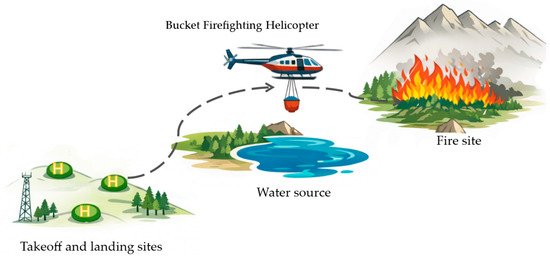
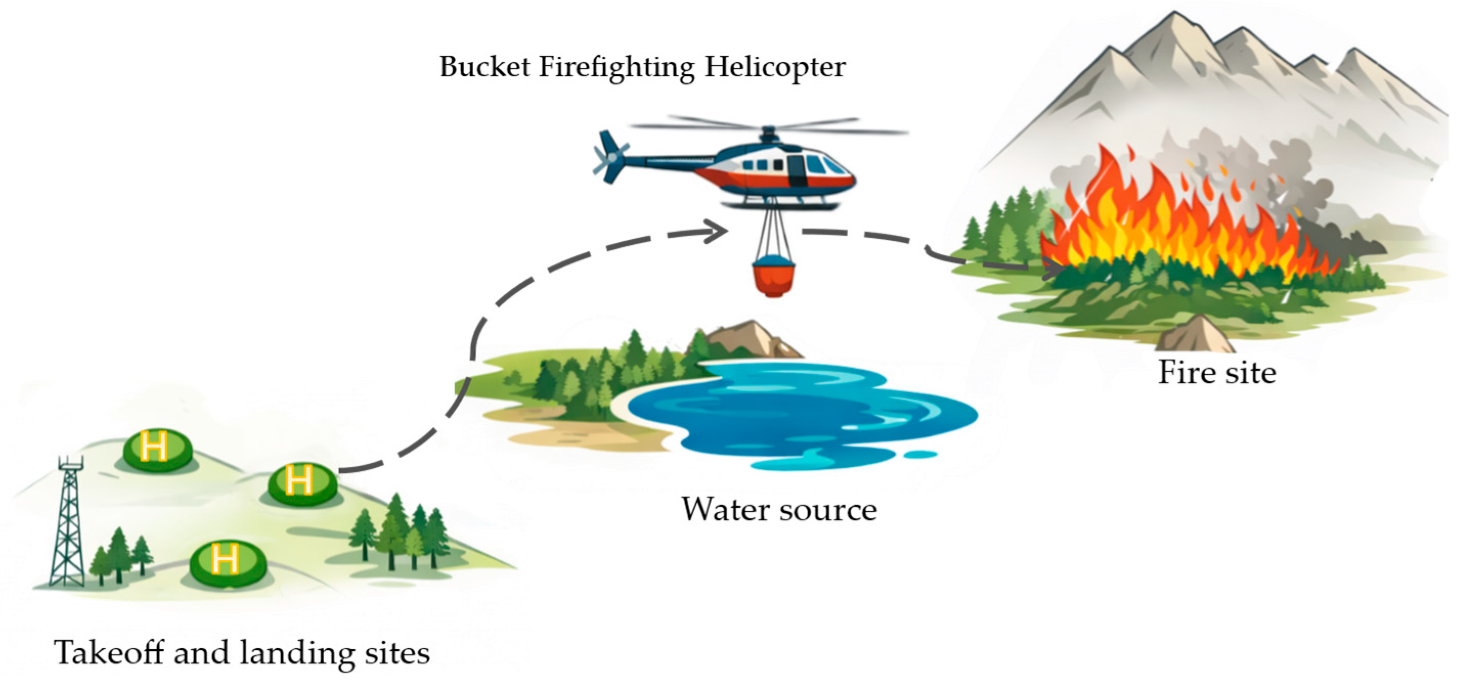
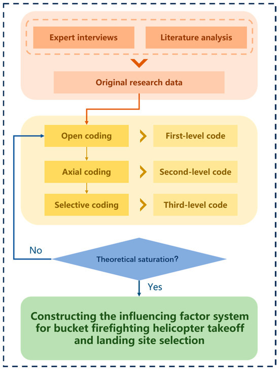
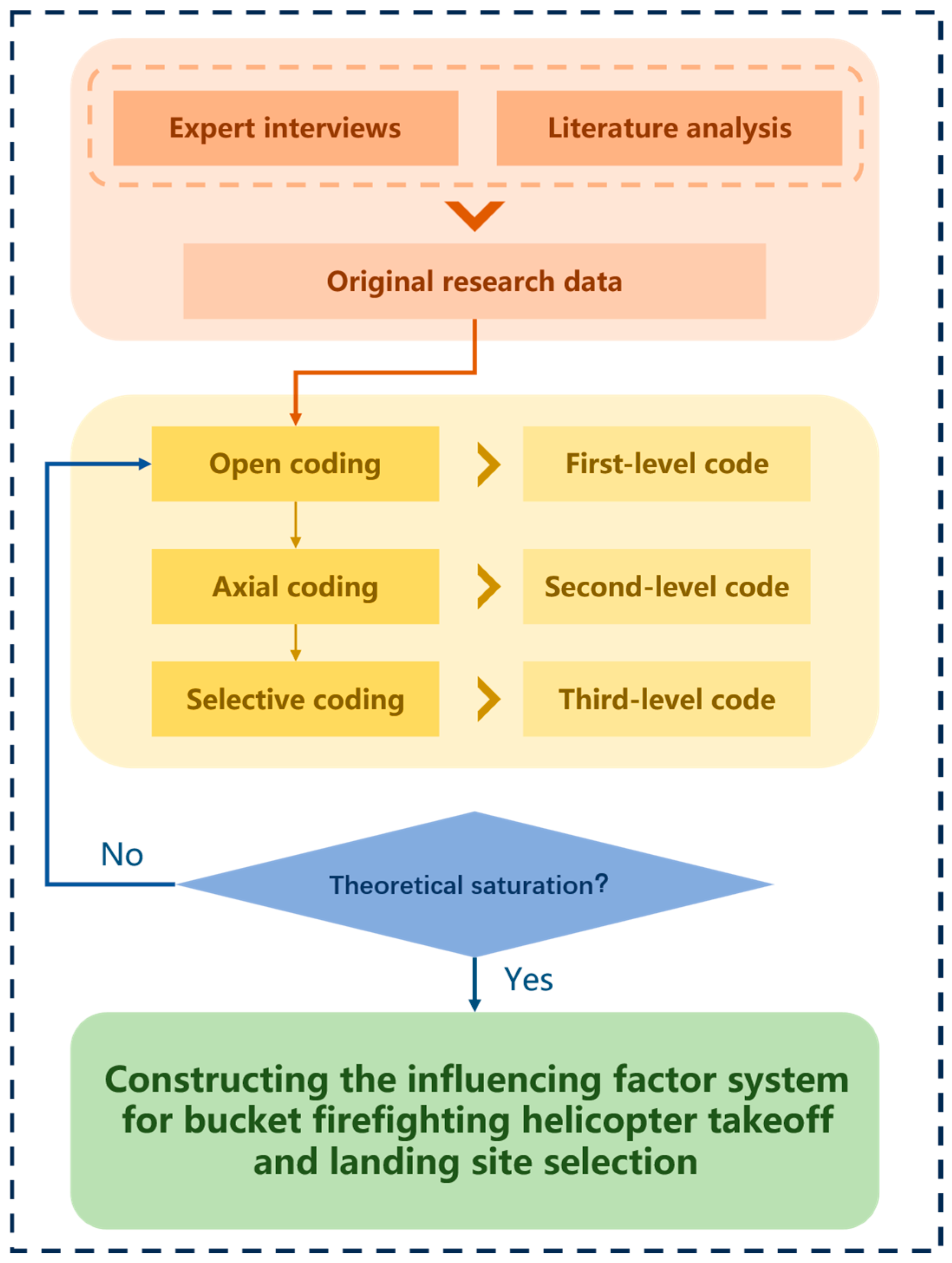
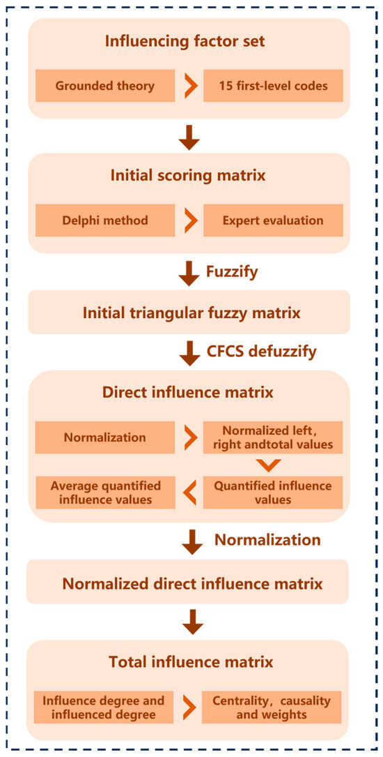
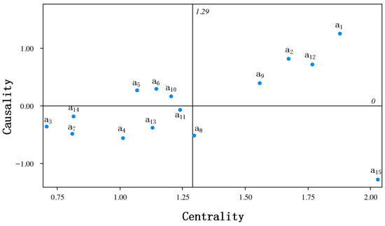

Disclaimer/Publisher’s Note: The statements, opinions and data contained in all publications are solely those of the individual author(s) and contributor(s) and not of MDPI and/or the editor(s). MDPI and/or the editor(s) disclaim responsibility for any injury to people or property resulting from any ideas, methods, instructions or products referred to in the content. |
© 2026 by the authors. Licensee MDPI, Basel, Switzerland. This article is an open access article distributed under the terms and conditions of the Creative Commons Attribution (CC BY) license.